Register      Login
International Journal of Wildland Fire International Journal of Wildland Fire Society
Journal of the International Association of Wildland Fire
Table of Contents
   

Volume 34 Number 1 2025

WF23196Evaluating a simulation-based wildfire burn probability map for the conterminous US

Amanda R. Carlson 0000-0002-0450-2636, Todd J. Hawbaker, Lucas S. Bair, Chad M. Hoffman, James R. Meldrum 0000-0001-5250-3759, L. Scott Baggett and Paul F. Steblein

An FSim burn probability (BP) map for the conterminous US was compared with observed wildfires from 2016 to 2022 in order to evaluate the suitability of wildfire simulation models for quantifying near-future wildfire risk. Our results highlight where burn probability models may be improved by incorporating dynamic weather and human influences.

WF24136Methods to assess fire-induced tree mortality: review of fire behaviour proxy and real fire experiments

Alistair M. S. Smith, Raquel Partelli-Feltrin 0000-0002-5076-8515, Aaron M. Sparks, James G. Moberly, Henry D. Adams, Dylan W. Schwilk, Wade T. Tinkham 0000-0002-4668-7624, John R. Kok, David R. Wilson, Alex Thompson, Andrew T. Hudak, Chad M. Hoffman, James A. Lutz, Alexander S. Blanco, Mark A. Cochrane, Robert L. Kremens, Joseph Dahlen, Grant L. Harley, Scott W. Rainsford, Li Huang, Douglas D. Hardman, Luigi Boschetti and Daniel M. Johnson

We conduct a review of different fire behaviour proxies and real fire methods that have been used to assess the mechanisms of fire-induced mortality. We conclude that further research should assess mechanisms of fire-induced tree mortality using live plants in paired combustion laboratory and landscape fire experiments.

WF24161Assessing wildland fire suppression effectiveness with infrared imaging on experimental fires

Melanie Wheatley, Joshua M. Johnston, B. Mike Wotton, Douglas G. Woolford and David L. Martell

We suppressed a series of small-scale burns while actively monitoring fire behaviour with overhead infrared imagery to quantify the impact of suppression on fire behaviour and energy released from flaming fires. Infrared imaging can capture the changes in energy released from a fire due to known aspects of water application.

A Duff Moisture Code value of 20 is operationally used to indicate the threshold below which lightning fires will not ignite and duff consumption will not occur. Through an analysis of historical lightning and fire data across Canada, we do not find strong evidence to support this threshold.

WF24114Towards a wildfire vulnerability index using expert judgement

M. Papathoma-Köhle 0000-0002-7878-1340, D. Hausharter, M. Schlögl 0000-0002-4357-523X and S. Fuchs

This paper describes a wildfire vulnerability index for buildings in Austria based on the characteristics of buildings and their surroundings, expert judgement and the analytic hierarchy process (AHP). The results can be used for emergency management and disaster risk reduction strategies in the wildland–urban interface.

WF24130Simulating wildfire spread based on continuous time series remote sensing images and cellular automata

Huajian Zhuang, Naian Liu, Xiaodong Xie, Xuan Xu, Mengmeng Li, Yang Zhang and Rui Wang

The simulation of wildfire propagation presents a complex system engineering challenge. The adaptive simulation method enables acquisition of highly precise results. The TCA model demonstrated its capability to achieve localised and gradual propagation. The created simulation software can serve as a powerful tool for wildland surface fire prevention and control.

WF24117Simplifying emissions modelling from wildland fires: laboratory-scale emission factors are independent of fine woody debris fuel load

Élise-Andrée Guérette 0000-0002-8774-7179, Clare Paton-Walsh 0000-0003-1156-4138, Maximilien Desservettaz, Fabienne Reisen, Nicholas C. Surawski, C. P. (Mick) Meyer, Christopher T. Roulston 0000-0003-1888-4206, Andrew Sullivan 0000-0002-8038-8724, Christopher J. Weston and Liubov Volkova 0000-0002-4556-3478

Emissions of most pollutants from laboratory-based experimental wildland fires are shown to be independent of the fraction of fine woody debris in the fuel load and to closely track the emissions of carbon monoxide in time, thereby simplifying modelling. Approximately half the emissions occur during the flaming stage of combustion.

WF24113Sub-hourly forecasting of fire potential using machine learning on time series of surface weather variables

Alberto Ardid, Andres Valencia, Anthony Power, Matthias M. Boer, Marwan Katurji, Shana Gross and David Dempsey

This study introduces a machine learning model to forecast fire potential using weather data from the Sunshine Coast, Australia. The model, which updates every 30 min, significantly improves fire prediction accuracy, helping to provide timely warnings and enhance fire management strategies.

WF24137Modelling and mapping burn severity of prescribed and wildfires across the southeastern United States (2000–2022)

Melanie K. Vanderhoof 0000-0002-0101-5533, Casey E. Menick, Joshua J. Picotte, Kevin M. Robertson, Holly K. Nowell, Chris Matechik and Todd J. Hawbaker

This effort produced novel burn severity data for many small and prescribed fires on both public and private lands across the Southeast. We evaluated spatial and temporal patterns in regional burn severity by vegetation type, as well as for fires attributed as prescribed or wildfire.

Fourier Transform Infrared spectra are presented for swamp sediments in the Blue Mountains, Australia. Fire-affected sediments show an increase in the aromatic/aliphatic ratio. C and N content show no consistent trend with hypothesised fire layers. Existing fire record was extended by several decades to centuries.

Rural communities are increasingly impacted by smoke from wildfire and forest management. We conducted 46 semi-structured interviews with 56 residents and professionals in Parks, Arizona, USA, to determine the role of local social context in rural smoke adaptation and gauge interest in adaptation strategies that reduce exposure.

This study utilises a neural network model to analyse historical land management data in Colorado’s national forests. It incorporates environmental variables to understand factors influencing past fuel treatment decisions. This method offers insights for improving future forest management and wildfire prevention strategies.

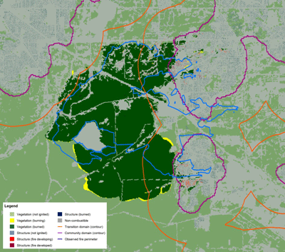
WF24027An offline coupling of fire spread models to simulate the 2021 Marshall Fire

Fernando Szasdi-Bardales 0000-0002-9643-5919, Kasra Shamsaei 0000-0003-3396-7683, Timothy W. Juliano, Branko Kosovic, Hamed Ebrahimian 0000-0003-1992-6033 and Negar Elhami-Khorasani

Map showing vegetation, built structures, impact of fire and fire perimeter for the 2021 Marshall Fire

Predictive models for wildfire spread can provide valuable information for risk mitigation. Current models focus only on wildland or community simulations. This paper integrates two models to simulate the 2021 Marshall Fire. The most accurate results are obtained using a high-resolution wind input and when incorporating different building types.

This study presents a proof-of-concept for estimating fine fuel consumption and accumulation by integrating forest inventory and fire records, aiming to refine fuel dynamics estimates and enhance current practices. We estimated FFL changes across different vertical strata in southeast Australian eucalypt forests, considering burn severity, fire type and forest cover.

Committee on Publication Ethics

Call for Papers

We are seeking contributions for the following Special Issues. More information

IJWF Content Free to IAWF Members

All non-OA journal content published prior to 2024 can be accessed by IAWF members through the IAWF Members-Only site.

Advertisement