

Compiling historical descriptions of past Indigenous cultural burning: a dataset for the eastern United States
Stephen J. Tulowiecki A *
A *
A
Abstract
The extent of past Indigenous cultural burning in the eastern US remains contested. Historical documents (e.g. early histories, journals, and reports) contain descriptions of burning. Scholars have summarised descriptions, but few have compiled them into databases.
This paper presents efforts to compile descriptions of past Indigenous burning in the eastern US and early results from mapped descriptions.
Utilising previously cited descriptions and those discovered from digitised historical texts, the current dataset mapped >250 descriptions of burning in the northeastern US. Most were historical summaries from 19th century authors, and fewer were firsthand observations. Descriptions are currently shared as a GIS data layer, a tabular file, and an interactive web map.
Descriptions correspond with fire-adapted vegetation, and clusters of descriptions suggest burning over large extents (e.g. southern New England, western New York). Estimated dates of burning or initial Euro-American settlement show an east–west succession in Indigenous fire exclusion and replacement with early Euro-American burning.
Historical descriptions suggest regional-extent influence of Indigenous burning upon past forested ecosystems, but the veracity of descriptions should be carefully evaluated.
This study provides a dataset for further examination of Indigenous burning and comparison with other methodologies for historical cultural fire reconstruction.
Keywords: eastern US, fire exclusion, historical fire regimes, Indigenous, land use, mesophication, Native American, northeastern US, oak, pine.
Introduction
There remains a debate over the geographic extent and intensity of past Indigenous land use, including fire, upon historical ecosystems of the eastern United States. Past Indigenous cultures employed various land-use practices that included cultural burning for reasons such as to prepare land for agriculture, clear landscapes for easing travel, promote edible or other favoured fire-tolerant plant species, create open woodlands with grasses that nourished game animals, and facilitate the hunting of game (Day 1953; Williams 2000; Stewart 2002; Abrams and Nowacki 2008). The Indigenous population in 1500 totalled between 0.5 and 2.6 million in the eastern US, though estimates vary widely (Milner and Chaplin 2010). Scholars have continued to renew this debate over several decades, most recently by paleoecologists and archaeologists claiming that Indigenous groups minimally impacted fire regimes over millennia in southern New England (Oswald et al. 2020), a claim that other researchers (Abrams and Nowacki 2020; Roos 2020) and Indigenous persons (Leonard et al. 2020) dispute. This exchange was only the most recent iteration of the debate (Denevan 1992, 2011; Vale 2002; Mann 2006), one extending back throughout the 20th century (e.g. see summaries in Patterson III and Sassaman 1988; Whitney 1996).
A related debate concerns the causes of ‘mesophication’ of forests during the 20th and 21st centuries, in which shade-intolerant, fire-tolerant tree species typical of open forests (e.g. oak [Quercus spp.] and pine [Pinus spp.]) are being replaced by shade-tolerant, fire-sensitive species (e.g. maple [Acer spp.]) to form closed forests (Nowacki and Abrams 2008). Researchers implicated various causes in this transition, including fire exclusion, climatic changes, changes in herbivore populations, and modern land-use change (McEwan et al. 2011; Hanberry et al. 2020), but fire exclusion is often argued as the main driver of mesophication. Understanding the extent and intensity of land clearance and burning is of utmost importance when ascribing potential causes of mesophication, and when setting modern land management targets. Understanding the extent of past burning influences discussions over whether to maintain declining fire-dependent plant communities and open forests (e.g. Ryan et al. 2013; Abrams et al. 2022), or to maximise carbon sequestration by protecting or promoting old-growth closed forests (e.g. Oswald et al. 2020; Kellett et al. 2023), goals that can directly oppose each other.
Researchers have examined descriptions from early explorers, colonists, travellers, naturalists, and historians of the circa 17th–19th centuries CE, to understand the spatial and temporal dimensions of Indigenous burning (Table 1). Notable syntheses of these descriptions include Flannery (1939) and Day (1953) for the northeastern US, Whitney (1996) for the northeastern and midwestern US, Cronon (1983) for New England, Higgins (1986) for the Northern Great Plains, McClain et al. (2021) for the Midwestern Tallgrass Prairie, Stewart (2002) for the Lower 48 US, Pyne (1982) and Williams (2005) for North America, and Scherjon et al. (2015) globally. Descriptions can provide eyewitness accounts of Indigenous peoples as an ignition source (as opposed to lightning), establish relationships between burning and open forest or grassland conditions, describe densification of forests once Indigenous burning ceased, and provide evidence of the seasonality of burning (e.g. Higgins 1986; McClain et al. 2021). While not all descriptions directly observed burning, some describe open forest conditions dominated by fire-adapted vegetation and attribute it to Indigenous land management. Early descriptions of burning have also been incorporated into land management plans (e.g. Keister 1998) and landscape histories (Cronon 1983; Tyndall and Hull 1999).
| Description | Firsthand | Specific event | Reforestation described | Connection to toponym | Estimates burned area | County and state | Year | Source | |
|---|---|---|---|---|---|---|---|---|---|
| ‘In some places where the Indians dyed of the Plague some fourteene yeares agoe, is much underwood, as in the mid way betwixt Wessaguscus and Plimouth, because it hath not beene burned; certaine Rivers stopping the fire from comming to cleare that place of the countrey, hath made it unusefull and troublesome to travell thorow, in so much that it is called ragged plaine, because it teares and rents the cloathes of them that passe.’ (sic) | Yes | No | Yes | Yes | No | Plymouth County, Massachusetts | 1634 | Wood (1865) | |
| ‘The townships of Chanceford, Lower Chanceford, Fawn Hopewell, and the Southern portion of Windsor, comprise what is usually denominated The York Barrens, amounting to one hundred and thirty thousand acres of arenaceous, gravelly and loamy soil. The term Barrens has not been applied to this portion of the county from the sterility of the soil; but from the circumstance that the Indians for many years and until 1730 or 1731, to improve this portion of their Great Park for the purpose of hunting, fired the copse or bushes as oft as their convenience seemed to call for it; and thus when the whites commenced settling here, they found no timber, hence they applied the term Barrens, a common appellation at that time, to such portions of country, however fertile the soil. Portions that were sixty or seventy years ago without any timber are now thickly covered with sturdy oaks, and large hickories.’ | No | No | Yes | Yes | Yes | York County, Pennsylvania | 1731 | Rupp (1845) | |
| ‘Among the early events that now occur to me, was the firing of lands by the Indians for the purpose of taking game. It was in 1795. The Indians to the number of at least five hundred assembled. At 12 o’clock in the day, they set a train of fire which enclosed an area of about seven miles square, of the oak openings between the Canascraga and Conesus lake.’ (sic) | Yes | Yes | No | No | Yes | Livingston County, New York | 1795 | Turner (1849) |
Authors of such syntheses of historical documents generally conclude that in the eastern US, forest and grassland burning was geographically widespread, was more concentrated in areas near Indigenous settlement, and occurred in climates that supported burning (e.g. Pyne 1982; Stewart 2002). While some have questioned the motivations of early observers (Russell 1983; Russell and Forman 1984), others have pointed out that respected early naturalists linked fire to large open landscapes when traveling eastern North America (Whitney 1996). For example, along the Ohio River circa 1788, a scientist and historian, Hildreth (1848), described open forests stating that Indigenous burning each autumn ‘destroyed all the shrubs and undergrowth of woody plants.’ A few studies have compared historical descriptions to other data or methodologies and found that descriptions correspond geographically with fire-adapted vegetation, woodlands, and/or grasslands described in historical land surveys, and/or model predictions of fire-dependent vegetation communities (Black et al. 2006; Tulowiecki et al. 2020a). Descriptions from historical documents complement and contrast with other evidence of burning from pollen or charcoal in paleoecological records (e.g. Oswald et al. 2020), tree-ring fire-scar records (e.g. Marschall et al. 2022), early land survey records (Thomas-Van Gundy et al. 2015; Tulowiecki et al. 2020a), and ethnographies (e.g. Parker 1910; Ruffner 2005).
Despite the value of historical descriptions to environmental historians and biogeographers for qualitatively assessing characteristics of Indigenous fire use, and to physical scientists as a form of validation for other methods, few efforts have sought to discover, catalogue and map early descriptions of Indigenous burning to make them more available for study and interpretation. Higgins (1986) assembled a compendium of nearly 300 firsthand historical accounts of burning in the Northern Great Plains from 1673 to 1880. Williams (2005) compiled an annotated bibliography predominantly of scholarly texts, but also some 17th–19th century historical descriptions on past Indigenous burning in North America. Scherjon et al. (2015) created a dataset of 231 descriptions of Indigenous burning from early ethnographies and historical texts, including 87 for North America. Using historical texts in western New York, Tulowiecki et al. (2020a) used information retrieval methods to find descriptions of Indigenous burning by searching for paragraphs containing keywords related to fire and Indigenous peoples. This lattermost study discovered 13 locations with descriptions in their study area and the descriptions were often located within 15 km from former Indigenous villages and trails. McClain et al. (2021) compiled 795 historical mentions of fire in the Midwestern Tallgrass Prairie, of which 32 were attributed to Native Americans between 1673 and 1836. Comparable efforts have mapped or compiled descriptions of past Indigenous agricultural techniques contained within early historical accounts and ethnographies across North America (Flannery 1939; Doolittle 2002). Worth noting are general searchable databases of the accounts of explorers and related figures in early American history that mentioned fire (e.g. Alexander Street 2024; Wisconsin Historical Society 2024).
This paper summarises an ongoing effort to compile and map historical descriptions of cultural burning by past Indigenous cultures in the eastern US. It presents an initial work for the northeastern US. Included in this compendium are previously cited descriptions both from earlier research, and descriptions discovered via information retrieval methods. It shares accounts as a GIS-format layer, a tabular file, and an interactive web map for those studying the distribution and characteristics of burning. It is expected that sharing this dataset will provide means of scholarly appraisal of such descriptions, and aid those seeking to compare and contrast historical descriptions with other data and methodologies that assess past fire regimes.
Compiling descriptions
This study first gathered historical descriptions of Indigenous burning from previously published scholarly works. These works include Bromley (1935), Day (1953), Stewart (2002), Pyne (1982), Cronon (1983), Whitney (1996), Williams (2005), and Scherjon et al. (2015). Also included were descriptions from publications specific to western New York (Tulowiecki et al. 2020a, 2020b). At the time of publication of this article this study focused upon gathering historical descriptions of the nine-state region of the northeastern US: Pennsylvania, New Jersey, New York, Connecticut, Rhode Island, Massachusetts, Vermont, New Hampshire, and Maine.
Also, a previously published information retrieval method (Tulowiecki et al. 2020b) was used for discovering new descriptions within digitised historical texts to augment the collection of descriptions derived from previous syntheses. Over 400 plain text format (.txt) county histories were searched, which were assembled from the author’s previous publication (Tulowiecki 2018). Thousands of digitised historical texts were also downloaded from the Internet Archive (2023), spanning the 16th–20th centuries that met keyword searches for terms such as ‘history’ along with state names. The ‘Cygwin’ terminal emulator and the ‘wget’ package (Chamberlain et al. 2022) was utilised in this latter approach to download these additional plain text documents in bulk, following a tutorial on the Internet Archive (Kaplan 2012). The major types of texts obtained from this lattermost approach were county, town, and other histories. An R script (R Development Core Team 2022; RStudio Team 2022) then broke plain text documents into paragraphs, tallied the number of certain keywords (e.g. ‘Indian’, ‘fire’, etc.) per paragraph, applied a predictive model to assign the paragraph a score based on keyword frequencies, and ranked the paragraphs by score in the final output (Tulowiecki et al. 2020b).
Summarising descriptions
Once descriptions were collected, several attributes were recorded in the initial version of the dataset (Table 2). Regarding the description itself, the following attributes were recorded: a one-sentence excerpt, a locational description, estimated latitude and longitude, an estimate of its positional uncertainty, description type (e.g. firsthand observation, historical summary), and the name of the firsthand observer if applicable. Also, recorded was an estimated associated year: either the year the burning occurred as stated by the observer, the estimated date the landscape was last burned, or the estimated date of the first white settlement, as provided within, preceding, or following the description. Metadata on the document containing the description were recorded such as author, title, year published, publisher, place published, and document type (e.g. county history, early journal/letter/account). To allow others to find and read the full description within the document, three additional attributes were recorded: the starting page number of the description, the first sentence in the paragraph of the description, and a hyperlink to the page containing the description within a scanned PDF on Internet Archive or Google Books. If present, also recorded were place names (toponyms) related to the burning or fire-related landscape conditions associated with the description, and their language of origin. Finally, occasional notes from the author of this publication were provided concerning various issues such as ambiguities interpreting the description. Unlike previous work that developed a dataset from more formal ethnographies (Scherjon et al. 2015), this study did not record attributes related to purposes of burning because in comparison to previous work, the descriptions analysed here were less detailed regarding characteristics of fire use.
| Attribute | Description | Possible values | Example value | |
|---|---|---|---|---|
| Object ID | A unique identifier for the description | (Various) | 53 | |
| One-sentence excerpt | A single sentence from the overall description of burning | (Various) | Among the early events that now occur to me, was the firing of lands by the Indians for the purpose of taking game. | |
| Location of description | Description of the location of the description | (Various) | between Canaseraga Creek and Conesus Lake, Town of Groveland, Livingston County, New York | |
| Latitude | Latitude of the centroid for the geographic location associated with the description (WGS 1984 datum) | (Various) | 42.739792 | |
| Longitude | Longitude of the centroid for the geographic location associated with the description (WGS 1984 datum) | (Various) | −77.781957 | |
| Positional uncertainty | Positional uncertainty of the description | Low (approximately <100 km2); medium (approximately <5000 km2); high (approximately <10,000 km2); very high (approximately >10,000 km2) | low | |
| Year associated | Estimated year that the burning occurred or ceased | (Various) | 1795 | |
| Description type | Type of description | Firsthand observation; firsthand observation – specific event; firsthand observation of cleared landscape with speculation of cause; historical summary; place-name translation | Firsthand observation of burning - specific event | |
| Firsthand observer | The name of the firsthand observer, if relevant | (Various) | John M’Kay | |
| Has toponym? | Whether there is a toponym (place name) in English or Indigenous related to the burning | English, Indigenous | English | |
| Related place name | Place name related to the burning, or to landscape conditions purportedly due to the burning | (Various) | Groveland Hill | |
| Document link | A link to the page with the description within a scanned PDF (on Internet Archive or Google Books) | (Various) | https://archive.org/details/pioneerhistoryof00turn/page/381/mode/1up?view=theater | |
| Starting page | Starting page number of the description within the document | (Various) | 381 | |
| First sentence in paragraph | First sentence in the first paragraph containing the description | (Various) | I came to what is now Groveland, on the Genesee River, in 1793, in my 16th year. | |
| Document author | Author of the document containing the description | (Various) | Turner, Orsamus | |
| Year published | Year of the document containing the description | (Various) | 1850 | |
| Document title | Title of the document containing the description | (Various) | Pioneer History of the Holland Purchase of Western New York | |
| Document publisher | Publisher of the document containing the description | (Various) | Jewett, Thomas & Co. | |
| Place published | Place the document containing the description was published | (Various) | Buffalo, NY, USA | |
| Document type | Type of document containing the description | Early journal/letter/account; county history; regional history; town history; other history; other | Regional history | |
| Notes | Miscellaneous notes about the description | (Various) | Firsthand account of fire-hunting |
Descriptions were then mapped as points representing the ‘best-guess’ location where the burning occurred, typically the centre of the geographic area associated with the description. Points versus polygons were utilised because they allowed greater cartographic clarity and flexibility in portraying the descriptions (see next section). Points describing the same geographic area were plotted on top of each other. A portion of descriptions was interpreted and digitised by students in upper-level undergraduate geographic information systems (GIS) courses.
Sharing descriptions
Currently the descriptions are provided as a GIS point vector layer (geodatabase [.gdb] feature class), a tabular file (.xlsx), and an interactive web map (https://go.geneseo.edu/HDICB). The decision to provide the data as a single GIS layer, rather than as a relational database (e.g. with document metadata in one table, descriptions in another, etc.), was made to provide ease of access for potential incorporation into future studies and comparison with findings from other methods of studying past fire regimes in GIS software. The GIS layer and tabular file versions are available from the NOAA NCEI World Data Service for Paleoclimatology archives at https://www.ncei.noaa.gov/access/paleo-search/study/39659.
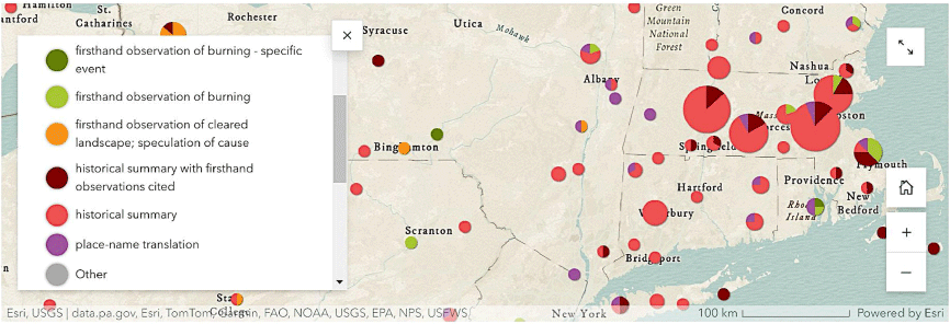
The interactive ArcGIS Story Map currently contains multiple thematic maps (Table 3) that convey various aspects of the descriptions based upon their attributes (Table 2). Each thematic map includes clickable symbols with pop-ups that show the attributes described above, along with a hyperlink to the full description. Where multiple descriptions existed, a pop-up yields multiple descriptions that users can page between. Sometimes utilised were proportional symbol pie chart symbology: the size of the point symbol conveys the number of descriptions within an area, and the size of each ‘slice’ represents a percentage of total descriptions that possessed a certain attribute (Fig. 1). Often utilised was automated point clustering: the number of descriptions aggregated into a common proportional symbol is dependent upon the scale at which a map user views the map, yielding a cleaner presentation of symbology. Also, a call to historians and scholars to share other known descriptions contained within texts will be included in the Story Map.
| Map | Type | Notes | |
|---|---|---|---|
| Description type | Proportional-symbol pie chart map | Larger = more descriptions at a location; hues of pie chart ‘slices’ represent the different types of descriptions at a location | |
| Year associated | Point map with sequential colours | Darker colour = more recently burned; labelled with associated year | |
| Firsthand observer | Simple point map | Points record locations where firsthand observers witnessed burning; labelled with name of firsthand observer | |
| Toponyms | Categorical point map | Three categories, each with a different colour hue: English, Native American, none | |
| Positional uncertainty | Proportional-symbol pie chart map | Larger = more descriptions at a location; hues of pie chart ‘slices’ represent the different levels of positional uncertainty | |
| Document type | Proportional-symbol pie chart map | Larger = more descriptions at a location; hues of pie chart ‘slices’ represent the different types of documents containing descriptions at a location |
See Table 2 for explanation of mapped attributes.
A screenshot of a proportional-symbols pie chart map within the current web map (https://go.geneseo.edu/HDICB), showing the number and type of descriptions in a general location. Larger circles represent a higher number of descriptions.
Descriptions compiled for the northeastern US
Results presented here summarise descriptions from the northeastern US compiled at the time of publication. A total of 253 unique combinations of description and location were mapped throughout the nine-state region (Fig. 1). Some descriptions described more than one location: for example, one traveller speculated on the causes of ‘oak plains’ in western New York at 11 locations (Dwight 1828). Around 200 geographic locations (e.g. a town, a county, a region) possessed at least one description. Around half of the descriptions described burning somewhere within towns, comparably-sized municipal divisions (e.g. boroughs, townships), or smaller municipal divisions (e.g. villages). Around one quarter described burning or burned landscapes at specific locales (e.g. hills, islands, locations along rivers), and around one tenth described burning or burned landscapes somewhere within a county. The remaining descriptions pertained to burning across or somewhere within states or regions of variable sizes. About two thirds of the descriptions possessed ‘low’ positional uncertainty, resolvable to somewhere within an approximately 100 km2 area. Just over 70% of descriptions were summaries from histories (often 19th century), whereas around 10% were firsthand observations of burning. Just 7 out of 253 were historical descriptions of specific burning events, whereas 20 were contemporary observers of early burning who summarised their observations. Around one quarter of descriptions mentioned place names associated with fire or burned landscapes, in either English (e.g. ‘Burnt Hills’) or Indigenous languages. Year associated with the fire event, burned landscape, or date of white settlement ranged from 1524 to 1867 (interquartile range = 1643–1783) with a median of 1675, and manifested a clear pattern from east (older dates) to west (more recent dates). Dates for firsthand observations ranged from 1524 to 1867 (interquartile range = 1643–1804) with a median of 1795. Note that the date 1524 was from John de Verrazzano’s ambiguous description of a ‘well peopled’ region with a ‘great number of fires’ around present-day Narragansett Bay, Rhode Island (1860). Nearly 180 documents provided the historical descriptions mapped in the northeastern US; the middle 50% (interquartile range) of publication dates ranged from 1861 to 1898, with a median date of 1883 and the earliest date of 1634.
The current dataset is representative of major themes in previous research such as the connections between fire and open forests, woodlands, or savannas with fire-tolerant species (Fig. 2) such as oak, hickory (Carya spp.), pine, and chestnut (Castanea dentata); reforestation after fire exclusion; the use of fire predominantly for clearing landscapes for agriculture, hunting, and travel benefits; and continuity in burning from Indigenous to initial white possession of the land. Descriptions in the current dataset also contain less-emphasised themes from previous research. While most descriptions state that the purpose of burning was to clear landscapes, occasional descriptions mention the use of fire to drive away enemies during conflicts, and at least three descriptions (two purportedly firsthand) in western New York and northwestern Pennsylvania mentioned the use of burning to kill rattlesnakes (Crotalus spp.; Sistrurus spp.). Occasionally, writers or observers estimated the sizes of burned areas: 3 km2 on Cape Cod in 1603 (Pring 1906) and 18 km2 in the Genesee Valley in 1795 (Turner 1849) in single events; 8 km in length near Plymouth from a contemporary observer (Winslow 1622); and 4 km2 in the Genesee Valley (Clayton 1879) or even 526 km2 in southeastern Pennsylvania (Rupp 1845) in general descriptions of fire-maintained areas. Spatial correspondence between place names and other types of descriptions existed: for example, firsthand accounts of burning that occurred on ‘Groveland Hill’ in western New York, and ‘Schooset’ or ‘fire place’ (Huden 1962) and ‘Ragged Plain’ (Wood 1865) coincided with an area with forest regrowth after fire exclusion in 17th century Plymouth County, Massachusetts. Descriptions also occasionally speculate on the frequency and seasonality of burning, often describing burning as occurring once or twice per year in the spring and/or autumn. However, the seasonality suggested from the few firsthand observations of specific events that possessed dates was variable: early June 1769 in central New York (Smith 1906), early September 1609 off the coast of New Jersey (Juet 1860), and early December 1632 off the Delaware Coast (de Vries 1853), for example.
Historical descriptions of Indigenous burning from this study versus estimated pre-Euro-American fire-adapted tree taxa, namely oak, hickory, chestnut, and pine combined. Fire-adapted tree taxa abundance was statistically estimated from witness-tree tallies of original land survey records circa 1620–1825 (Paciorek et al. 2016). Some descriptions have been slightly moved so that all are visible. Only descriptions with ‘low’ or ‘medium’ positional uncertainty are shown (n = 217).

A few descriptions incorporated legal anecdotes related to Indigenous burning. For example, at least eight towns - but ‘probably most, if not all the towns’ (Wood 1828) - passed laws requiring residents to remove underbrush that established after fire exclusion in the plains of western Long Island; the same towns created laws to conserve timber by preventing the sale of timber outside the town. In 1671 the New York governor even required brush removal across the entire island due to deteriorating grasslands from invading shrubs and saplings – perhaps one of the earliest references to mesophication and forest densification in the eastern US. Early towns in the Connecticut River Valley also enacted brush-clearing and wood conservation laws soon after Euro-American settlement (Judd 1860). In Mastic on eastern Long Island in 1700, one description noted an early white landowner who leased lands to 11 Indigenous persons to plant crops and burn the forest (Bayles 1882).
From these initial accounts mapped, four locations emerged as major regions with altered landscapes through Indigenous burning, judging from the number and veracity of the accounts: southern New England, western Long Island, southeastern Pennsylvania, and western New York (Fig. 1). Southern New England contained multiple canonical firsthand accounts of Indigenous burning in the 17th century (Winslow 1622; Williams 1643; Wood 1865; Morton 1883), fire-related place names, and descriptions of early white settlers who appropriated Indigenous-maintained fields and hunting grounds (e.g. within the Connecticut River Valley). As noted above, writers in western Long Island described large treeless tracts that whites adopted as early pastures in the 17th century. Writers in southeastern Pennsylvania described expanses maintained in a treeless condition by Indigenous burning until around 1731, after which time forest regrowth was noted (Table 1). Relying on previous compilations of historical descriptions (Tulowiecki et al. 2020a, 2020b), western New York contained numerous descriptions of oak savannas and burned landscapes including a few firsthand accounts centred upon the Genesee River Valley and western Finger Lakes in the late 18th century.
Correspondence with previous scholarship
This study produced a comparable number of historical descriptions or accounts as previous similar compendiums (e.g. Higgins 1986; Scherjon et al. 2015). Unlike previous efforts, however, this study spatialised historical descriptions to produce new geographic insight. Initial mapping of historical descriptions generally supported the conclusions of previous scholars utilising descriptions to reveal spatial and temporal characteristics of Indigenous burning (e.g. Pyne 1982; Stewart 2002): it was geographically widespread in regions with both Indigenous settlement and climates conducive to fire. While the current dataset indicated that relatively few descriptions were firsthand accounts, and thus supports previous statements regarding the paucity of such accounts (Russell 1983), descriptions by 19th century historians collectively suggest the plausibility of local- to regional-extent influences of fire upon forested ecosystems in portions of the northeastern US (Fig. 1), and refutes research claiming minimal influence of Indigenous groups upon fire regimes and forested ecosystems in the northeastern US (Oswald et al. 2020). Historical descriptions generally corresponded with the distribution of fire-adapted tree taxa (i.e. oak, hickory, chestnut, and pine) prior to Euro-American settlement (Fig. 2), especially in southern New England, suggesting at least a partial causal relationship between fire and fire-adapted vegetation in addition to climatic and soil factors (Thomas-Van Gundy et al. 2015; Tulowiecki et al. 2022). The initial collection of descriptions also reinforces and suggests the temporal sequence of changing fire regimes: it reveals a clear east-to-west land-use transition with the exclusion of Indigenous fire, and replacement with early Euro-American burning practices (Pyne 1982; Stambaugh et al. 2018; Margolis et al. 2022).
Data quality considerations
This paper acknowledges data quality issues when interpreting the content and patterns in descriptions of Indigenous burning. The geographical pattern in historical descriptions is not an unbiased sample: descriptions were generally produced where little or no time elapsed between Indigenous and white settlement, and where Euro-American population density was high enough to produce individuals that wrote historical documents. The earliest descriptions of burned landscapes from colonists, and particularly those who also describe easily-traversed open landscapes, may be painting overly favourable views of the New World to entice settlers to emigrate (Russell 1983; Russell and Forman 1984; Patterson III and Sassaman 1988). Descriptions are often the perspectives of avocational historians, white settlers, travellers, missionaries, trappers, and others, oftentimes without scholarly backgrounds. Some may be speculative, biased, be highly derivative of earlier texts, possess high positional uncertainty, or mischaracterise the intent of Indigenous use of fire. Like previous research (Higgins 1986), in a few descriptions it was unclear whether Indigenous or early whites were burning forests: for example, a traveller in 1803 noted mountains ‘for more than fifty miles…burning…by the hunters’ (Harris 1805).
On the other hand, some 19th century historians purportedly performed rigorous analysis of early town documents and firsthand accounts to reach conclusions regarding the geographical extent of Indigenous burning (e.g. Wood 1828; Judd 1860). Moreover, previously mentioned studies have corroborated historical descriptions using other evidence such as early land survey records (e.g. Tulowiecki et al. 2020a), giving greater weight to such descriptions. Historical descriptions of burning compiled in this study thereby possess varying levels of reliability across four centuries, requiring caution during future interpretation.
Conclusion and future directions
This paper presented a novel and ongoing effort to develop and disseminate a dataset of historical descriptions of Indigenous cultural burning from historical texts. Future work will expand upon this dataset in later version releases by adding new descriptions from throughout the eastern US with comparable document density, coding new attributes, and calling for historians and scholars to contribute additional descriptions from undigitised and/or obscure documents. This effort could also be expanded by incorporating Indigenous knowledge and recollections in public memory. Coupled with previous efforts (e.g. Stewart 2002; Williams 2005; Scherjon et al. 2015; Tulowiecki et al. 2020b; McClain et al. 2021), this paper demonstrates that Native American cultural burning was described at least hundreds to thousands of times in historical documents in North America. Such historical descriptions, and methods used in this study to discover them, may also be of value to understanding historical distributions of fauna and their connections to semi-open ecosystems and fire regimes. This study also suggested a few new directions in research; for example, a greater analysis of early colonial policies (Kawashima and Tone 1983) related to brush-clearing and timber conservation may suggest locations where Indigenous burning maintained semi-open landscape conditions that early Euro-Americans encountered. The dataset developed here represents only one line of evidence regarding the geographic extent and intensity of Indigenous burning, and it is acknowledged that it possesses biases and other forms of limitations. Echoing previous calls for multiproxy evidence at local scales (Scherjon et al. 2015), this resource can contribute to future multidisciplinary or interdisciplinary research that compares and contrasts historical descriptions with findings from other methodologies, to lend greater confidence in the reconstruction and assessment of past fire regimes.
Data availability
The GIS layer and tabular file versions of the dataset containing historical descriptions are available from the NOAA NCEI World Data Service for Paleoclimatology archives at https://www.ncei.noaa.gov/access/paleo-search/study/39659. The descriptions are also currently provided in the web map at https://go.geneseo.edu/HDICB.
Acknowledgements
S. J. T. thanks students in his upper-level GIS courses who digitised a portion of the descriptions for this study, especially Emma M. Barrett, Mary E. Oldendorf, and Scott V. Williams. S. J. T. also thanks historians who assisted in the early phases.
References
Abrams MD, Nowacki GJ (2008) Native Americans as active and passive promoters of mast and fruit trees in the eastern USA. Holocene 18, 1123-1137.
| Crossref | Google Scholar |
Abrams MD, Nowacki GJ (2020) Native American imprint in palaeoecology. Nature Sustainability 3, 896-897.
| Crossref | Google Scholar |
Abrams MD, Nowacki GJ, Hanberry BB (2022) Oak forests and woodlands as Indigenous landscapes in the Eastern United States. Journal of the Torrey Botanical Society 149, 101-121.
| Crossref | Google Scholar |
Alexander Street (2024) Early Encounters in North America: Peoples, Cultures, and the Environment. Available at https://alexanderstreet.com/products/early-encounters-north-america-peoples-cultures-and-environment [accessed 20 June 2024]
Black BA, Ruffner CM, Abrams MD (2006) Native American influences on the forest composition of the Allegheny Plateau, northwest Pennsylvania. Canadian Journal of Forest Research-Revue Canadienne De Recherche Forestière 36, 1266-1275.
| Crossref | Google Scholar |
Bromley SW (1935) The original forest types of southern New England. Ecological Monographs 5, 61-89.
| Crossref | Google Scholar |
Chamberlain S, Cygnus Solutions, Red Hat (2022) Cygwin64 3.4.9-1. Available at https://cygwin.com/ [verified 20 June 2024]
Day GM (1953) The Indian as an ecological factor in the northeastern forest. Ecology 34, 329-346.
| Crossref | Google Scholar |
Denevan WM (1992) The pristine myth: the landscape of the Americas in 1492. Annals of the Association of American Geographers 82, 369-385.
| Crossref | Google Scholar |
Denevan WM (2011) The ‘pristine myth’ revisited. Geographical Review 101, 576-591.
| Crossref | Google Scholar |
Hanberry BB, Abrams MD, Arthur MA, Varner JM (2020) Reviewing fire, climate, deer, and foundation species as drivers of historically open oak and pine forests and transition to closed forests. Frontiers in Forests and Global Change 3, 56.
| Crossref | Google Scholar |
Higgins KF (1986) Interpretation and Compendium of Historical Fire Accounts in the Northern Great Plains. (United States Department of the Interior, Fish and Wildlife Service, Resource Publication 161: Washington DC, USA) Available at https://ecos.fws.gov/ServCat/DownloadFile/113398?Reference = 73447 [verified 20 June 2024]
Internet Archive (2023) About the Internet Archive. Available at https://archive.org/about/ [verified 20 June 2024]
Kaplan J (2012) Downloading in bulk using wget. Internet Arch. Available at https://blog.archive.org/2012/04/26/downloading-in-bulk-using-wget/ [verified 20 June 2024]
Kawashima Y, Tone R (1983) Environmental policy in early America: a survey of colonial statutes. Journal of Forest History 27, 168-179.
| Crossref | Google Scholar |
Kellett MJ, Maloof JE, Masino SA, Frelich LE, Faison EK, Brosi SL, Foster DR (2023) Forest-clearing to create early-successional habitats: Questionable benefits, significant costs. Frontiers in Forests and Global Change 5, 1073677.
| Crossref | Google Scholar |
Leonard K, Aldern JD, Christianson AC, Ranco D, Thornbrugh C, Loring PA, Coughlan MR, Jones P, Mancini J, May D, Moola F, Williamson G, Stoff CR (2020) Indigenous Conservation Practices Are Not a Monolith: Western cultural biases and a lack of engagement with Indigenous experts undermine studies of land stewardship. 10.32942/osf.io/jmvqy
Margolis EQ, Guiterman CH, Chavardès RD, Coop JD, Copes-Gerbitz K, Dawe DA, Falk DA, Johnston JD, Larson E, Li H, Marschall JM, Naficy CE, Naito AT, Parisien M-A, Parks SA, Portier J, Poulos HM, Robertson KM, Speer JH, Stambaugh M, Swetnam TW, Tepley AJ, Thapa I, Allen CD, Bergeron Y, Daniels LD, Fulé PZ, Gervais D, Girardin MP, Harley GL, Harvey JE, Hoffman KM, Huffman JM, Hurteau MD, Johnson LB, Lafon CW, Lopez MK, Maxwell RS, Meunier J, North M, Rother MT, Schmidt MR, Sherriff RL, Stachowiak LA, Taylor A, Taylor EJ, Trouet V, Villarreal ML, Yocom LL, Arabas KB, Arizpe AH, Arseneault D, Tarancón AA, Baisan C, Bigio E, Biondi F, Cahalan GD, Caprio A, Cerano-Paredes J, Collins BM, Dey DC, Drobyshev I, Farris C, Fenwick MA, Flatley W, Floyd ML, Gedalof Z, Holz A, Howard LF, Huffman DW, Iniguez J, Kipfmueller KF, Kitchen SG, Lombardo K, McKenzie D, Merschel AG, Metlen KL, Minor J, O’Connor CD, Platt L, Platt WJ, Saladyga T, Stan AB, Stephens S, Sutheimer C, Touchan R, Weisberg PJ (2022) The North American tree-ring fire-scar network. Ecosphere 13, e4159.
| Crossref | Google Scholar |
Marschall JM, Stambaugh MC, Abadir ER, Dey DC, Brose PH, Bearer SL, Jones BC (2022) Pre-Columbian red pine (Pinus resinosa Ait.) fire regimes of north-central Pennsylvania, USA. Fire Ecology 18, 11.
| Crossref | Google Scholar |
McClain WE, Ruffner CM, Ebinger JE, Spyreas G (2021) Patterns of Anthropogenic Fire within the Midwestern Tallgrass Prairie 1673–1905: Evidence from Written Accounts. Natural Areas Journal 41, 283-300.
| Crossref | Google Scholar |
McEwan RW, Dyer JM, Pederson N (2011) Multiple interacting ecosystem drivers: Toward an encompassing hypothesis of oak forest dynamics across eastern North America. Ecography 34, 244-256.
| Crossref | Google Scholar |
Milner GR, Chaplin G (2010) Eastern North American population at ca. A.D. 1500. American Antiquity 75, 707-726.
| Crossref | Google Scholar |
Nowacki GJ, Abrams MD (2008) The demise of fire and ‘mesophication’ of forests in the Eastern United States. Bioscience 58, 123-138.
| Crossref | Google Scholar |
Oswald WW, Foster DR, Shuman BN, Chilton ES, Doucette DL, Duranleau DL (2020) Conservation implications of limited Native American impacts in pre-contact New England. Nature Sustainability 3, 241-246.
| Crossref | Google Scholar |
Paciorek CJ, Goring SJ, Thurman AL, Cogbill CV, Williams JW, Mladenoff DJ, Peters JA, Zhu J, McLachlan JS (2016) Statistically-estimated tree composition for the northeastern United States at the time of Euro-American settlement. PLoS One 11, e0150087.
| Crossref | Google Scholar | PubMed |
R Development Core Team (2022) ‘R: A Language and Environment for Statistical Computing.’ (R Foundation for Statistical Computing: Vienna, Austria) Available at http://www.R-project.org
Roos CI (2020) Scale in the study of Indigenous burning. Nature Sustainability 3, 898-899.
| Crossref | Google Scholar |
RStudio Team (2022) ‘RStudio: Integrated Development Environment for R.’ (RStudio, Inc.: Boston, MA USA) Available at http://www.rstudio.com/
Russell EWB (1983) Indian-set fires in the forests of the Northeastern United States. Ecology 64, 78-88.
| Crossref | Google Scholar |
Russell EWB, Forman RT (1984) Indian burning, ‘the unlikely hypothesis’. Bulletin of the Ecological Society of America 65, 281-282.
| Crossref | Google Scholar |
Ryan KC, Knapp EE, Varner JM (2013) Prescribed fire in North American forests and woodlands: history, current practice, and challenges. Frontiers in Ecology and the Environment 11, e15-e24.
| Crossref | Google Scholar |
Scherjon F, Bakels C, MacDonald K, Roebroeks W (2015) Burning the land: an ethnographic study of off-site fire use by current and historically documented foragers and implications for the interpretation of past fire practices in the landscape. Current Anthropology 56, 299-326.
| Crossref | Google Scholar |
Smith R (1906) ‘A Tour of Four Great Rivers: The Hudson, Mohawk, Susquehanna and Delaware in 1769’. (Ed. FW Halsey) (Charles Scribner’s Sons: New York, NY USA). Available at https://archive.org/details/touroffourgreatr02smit
Stambaugh MC, Marschall JM, Abadir ER, Jones BC, Brose PH, Dey DC, Guyette RP (2018) Wave of fire: an anthropogenic signal in historical fire regimes across central Pennsylvania, USA. Ecosphere 9, e02222.
| Crossref | Google Scholar |
Thomas-Van Gundy MA, Nowacki GJ, Cogbill CV (2015) Mapping pyrophilic percentages across the northeastern United States using witness trees, with focus on four national forests. General Technical Report NRS-145. (United States Department of Agriculture - United States Forest Service - Northern Research Station: Newtown Square, PA USA)
Tulowiecki SJ (2018) Information retrieval in physical geography: A method to recover geographical information from digitized historical documents. Progress in Physical Geography: Earth and Environment 42, 369-390.
| Crossref | Google Scholar |
Tulowiecki SJ, Robertson DS, Larsen CPS (2020a) Oak savannas in western New York State, circa 1795: Synthesizing predictive spatial models and historical accounts to understand environmental and Native American influences. Annals of the American Association of Geographers 110, 184-204.
| Crossref | Google Scholar |
Tulowiecki SJ, Williams SV, Oldendorf ME (2020b) Discovering accounts of Native American burning within digitized historical documents using information retrieval methods. Vegetation History and Archaeobotany 29, 463-476.
| Crossref | Google Scholar |
Tulowiecki SJ, Ranney ER, Keenan EM, Neubert GM, Hogan ML (2022) Localized Native American impacts on past forest composition across a regional extent in north-eastern United States. Journal of Biogeography 49, 1099-1109.
| Crossref | Google Scholar |
Williams GW (2000) Introduction to aboriginal fire use in North America. Fire Management Today 60, 8-12.
| Google Scholar |
Williams GW (2005) ‘References on the American Indian use of fire in ecosystems.’ (USDA Forest Service: Washington, DC USA) Available at https://web.archive.org/web/20221017150226/https://www.nrcs.usda.gov/Internet/FSE_DOCUMENTS/nrcs144p2_051334.pdf [accessed 20 June 2024]
Winslow E (1622) ‘Mourt’s Relation: A Journal of the Pilgrims at Plymouth, 1622.’ (John Kimball Wiggin: Boston, MA, USA) Availabele at https://www.loc.gov/resource/gdcmassbookdig.mourtsrelationor00brad/?st=gallery
Wisconsin Historical Society (2024) American Journeys: Eyewitness Accounts of Early American Exploration and Settlement. Available at https://www.americanjourneys.org/search.asp [accessed 20 June 2024]