Beach and coastal dune systems of Two Peoples Bay Nature Reserve, Western Australia
Patrick A. Hesp A *
A *
A
Abstract
This paper is one of a series on the natural history of Two Peoples Bay Nature Reserve in Western Australia.
The geomorphology of the beach and coastal dune systems of Two Peoples Bay Nature Reserve are mapped and the landform units comprising the beach and dune systems are described.
An overview of the Two Peoples Bay–Nanarup beach-dune system comprising the Two Peoples Nature Reserve is provided.
The evolutionary patterns of the major dune forms are elucidated for this little-known area.
An understanding of the beach and coastal dune systems is necessary for effective management of the reserve.
Keywords: beach systems, coastal dune systems, Nanarup Beach, Two Peoples Bay.
Introduction
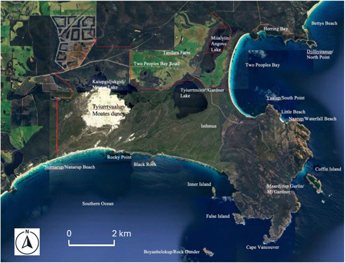
For the purposes of describing the beach-dune systems of the Two Peoples Bay–Nanarup area in south-western Australia, the area can be divided into two parts: that facing east (Two Peoples Bay) and that facing south (Nornarup/Nanarup Beach) (Fig. 1) (Noongar names for locations on Two Peoples Bay Nature Reserve, where known, are given before the European name and follow Knapp et al. 2024). Both Two Peoples Bay and Nornarup/Nanarup Beach contain a range of beach-dune environments. Their Quaternary geological history, their geomorphological evolution, current geomorphological processes, and attendant ecological and paedological processes are quite complex and little studied. Knowledge of the dynamics, age structure, and evolution of the system is extremely limited. The following provides an overview of the beach-dune system largely in the form of a photo-essay.
Two Peoples Bay Nature Reserve (boundaries shown in red) and locations mentioned in the text. Noongar names, where known, are given before the European name and are from Knapp et al. (2024). Source Google Earth. Map data: Google © 2020 CNES/Astrium, Maxar Technologies.
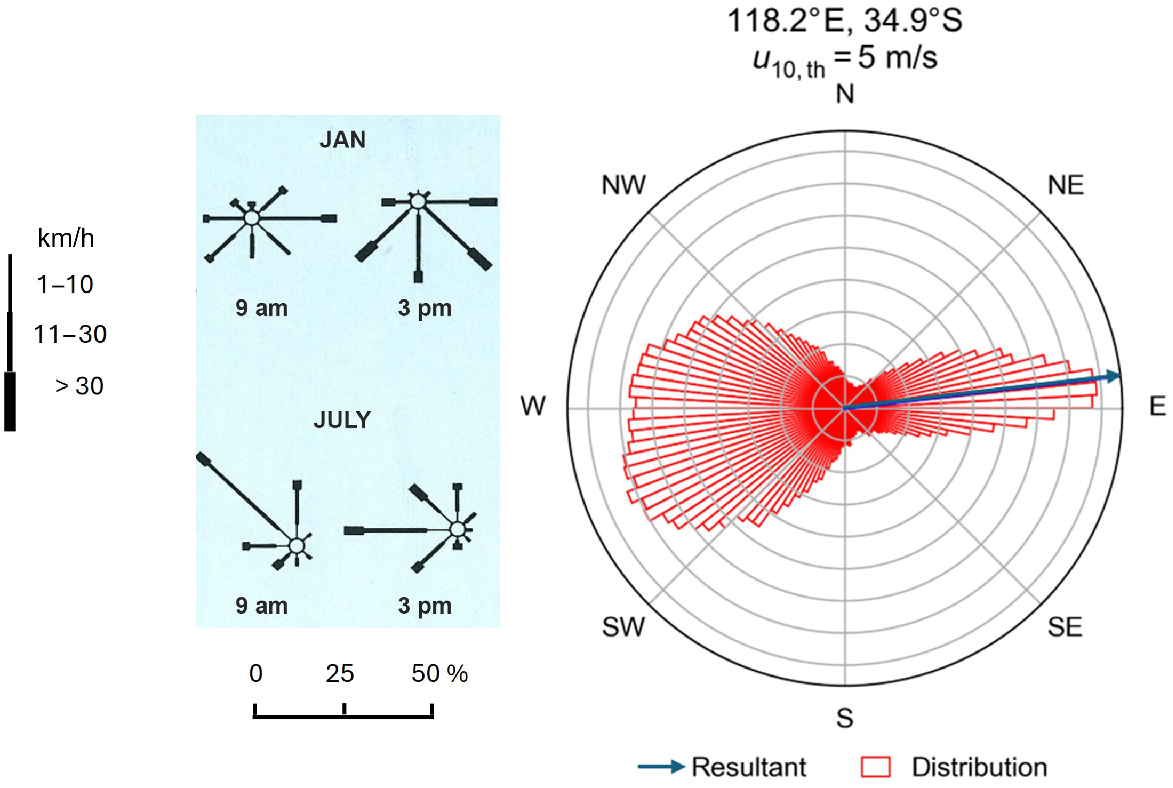
The south-west region of Western Australia is subject to 10–14 s period, moderate to high (2–3 m) swell waves, with south-west swells predominant (Short 2005). Short (2005) states that swell waves reach 3 m 40% of the year. Tides are microtidal (<1 m) with the mean spring tide range at Albany (about 40 km west of Two Peoples Bay) of 0.6 m. Winds predominantly blow from the westerly and easterly quadrants and are stronger and more north-westerly to westerly in winter (June–August) (Fig. 2). The potential net sand transport as indicated by the blue arrow vector resultant in Fig. 2 is to the east (see Miot da Silva and Hesp 2010 for details of Fryberger-Dean resultants).
Wind roses for January and July from Albany, and Fryberger-Dean ‘sand rose’ for the Two Peoples Bay Region based on ERA-5 data. The sand rose indicates all winds (in red) in the direction the wind is coming from, and the blue arrow indicates the resultant drift potential (RDP in vector units) that the sand will blow towards. Fryberger-Dean data courtesy of Andrew Gunn (Monash University). Albany wind data from Australian Bureau of Meteorology and Hesp and Chape (1984).
Two Peoples Bay
The Two Peoples Bay beach-surf-zone system is a modally intermediate type system (rhythmic bar and beach; Short 1979, 2005). It is composed of fine-grained siliceous sand. The surf-zone is typically characterised by a shore-parallel, crescentic bar and trough system with rips. The overall beach-surf-zone gradient is low because of the presence of fine sand.
Two Peoples Bay faces east and is not exposed to the full forces of the dominant south-west swell (Figs 1 and 3). Refracted wave energy is thus moderate and may be especially low for extensive periods, particularly in summer. Wave energy is greatest in the north and declines to the south, which is sheltered and therefore less exposed. This trend is reflected in the distribution of sea grasses. At the northern end of the bay the outer seagrass boundary is 100 m offshore, whereas at the southern end the seagrass inner limit is 20–30 m offshore. This boundary provides a good indication of the position of wave base in the bay (Fig. 1). Two Peoples Bay is significantly less exposed to the stronger westerly and north-westerly winds in comparison to Nornarup/Nanarup Beach, and this fact, combined with the significant differences in exposure to wave energy, explains the significant differences in dune development and volume between the two embayments – Nornarup/Nanarup Beach vs Two Peoples Bay. Sea breezes in summer (December–February) are onshore at Two Peoples Bay (Fig. 2) and likely are the dominant onshore winds driving aeolian sediment transport in that embayment.
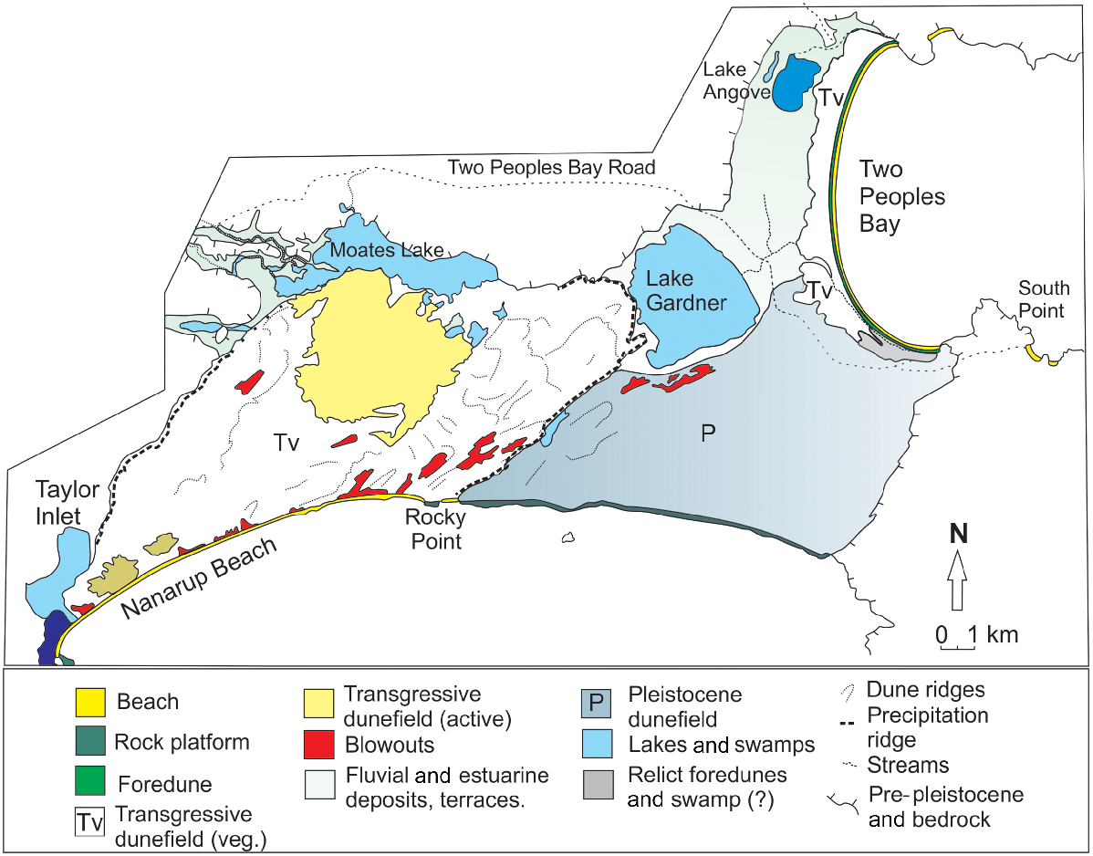
Geomorphological map of the Two Peoples Bay–Nanarup region. Drawn from unrectified 1981 stereo aerial photography.
Foredune
Foredunes are formed by aeolian (wind driven) sand deposition in pioneer plants on the backshore (Hesp 2024). The foredune is severely eroded during winter storms, which are mostly from the north-west to south-west with the storm waves being refracted into Two Peoples Bay. The established foredune can be significantly scarped during rare south-easterly storm events resulting in the removal of the incipient (or newly forming; aka embryo) foredune. Major erosion has occurred at various times leaving a large (3–4 m) scarp along the seaward face of the established foredune, and removing the incipient (or newly forming) foredune. Fig. 4 illustrates the foredune in 2021 showing a recent high scarp along the foredune, and the high percentage of vegetation cover along the dune.
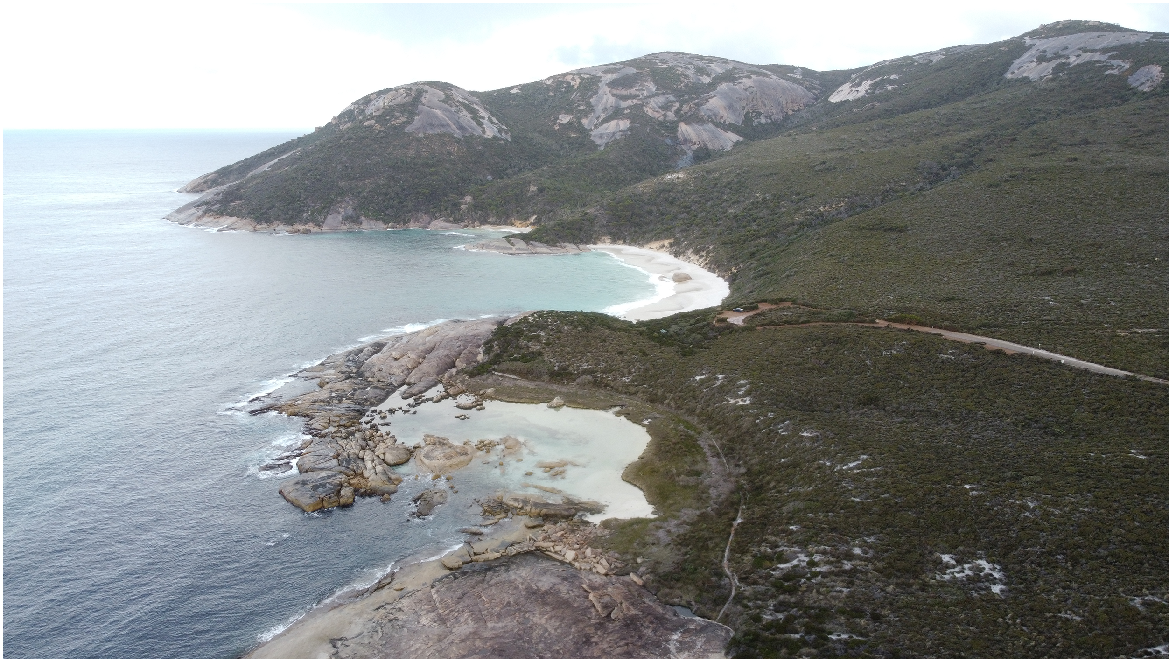
View of the foredune and beach system at the southern portion of Two Peoples Bay in 2021. Note the creek flowing southwards along the topographic low which separates the small transgressive dunefield from the foredune (author’s photograph).
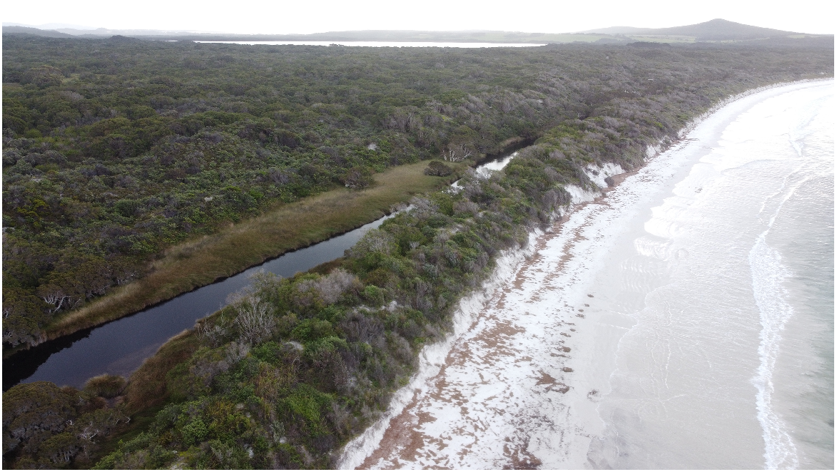
Aeolian (wind-blown) sand transport is low to moderate on the beach of Two Peoples Bay because there is apparently little sediment delivery by waves and exposure to strong winds is limited. Post-storm recovery (i.e. rebuilding of the dunes) is therefore slow. Given there is a north to south gradient in the distance seawards at which seagrass first appears, there is possibly a longshore gradient in alongshore sand transport towards the south; although the pronounced curvature and symmetry of Two Peoples Bay may indicate that this is not the case.
Holocene dunes
The Holocene (last 0–10,000 years Before Present (BP)) sand dunes backing Two Peoples Bay are well-vegetated, stable, and somewhat topographically chaotic, sub-parabolic (i.e. display arcuate ridge morphologies but little to no development of trailing ridges) and transgressive dunes. Transgressive dunefields are coastal aeolian sand deposits formed by the downwind, across and/or alongshore movement of sand over landward terrain (Hesp and Thom 1990). They ‘transgress’ older surfaces (Gardner 1955) and can vary in extent from relatively small to very large. They are the coastal equivalent of desert sand seas and ergs (Hesp et al. 2022; Courrech du Pont et al. 2024). They may form in multiple separate phases, and in temperate environments typically become vegetated over time (Hesp 2024). As plants colonise the dunefields, the relatively simple dune types (e.g. barchanoid and transverse dunes) are often changed into very complex forms as seen at Two Peoples Bay (and in the Nornarup/Nanarup dunefields). The transgressive dunes are limited in area, height, and volume and are best developed in the northern and central sections (Fig. 5). Fig. 5 shows that although some of the dunes closer to the foredune display a sub-parabolic shape with arcuate ridges and deflation basins, a significant portion of the dune system comprises sinuous to crenate (round-toothed or scalloped ridge form), and lobate ridges, some of which are relatively continuous and some short and discontinuous (see Toffani et al. 2024 for nomenclature).
Oblique view along the central to northern portion of the Two Peoples Bay dune system illustrating the foredune along the seaward edge, and the sub-parabolic/transgressive dunefield. Google Earth image November, 2017. Map data: Google, © 2020 CNES/Astrium, Maxar Techologies.
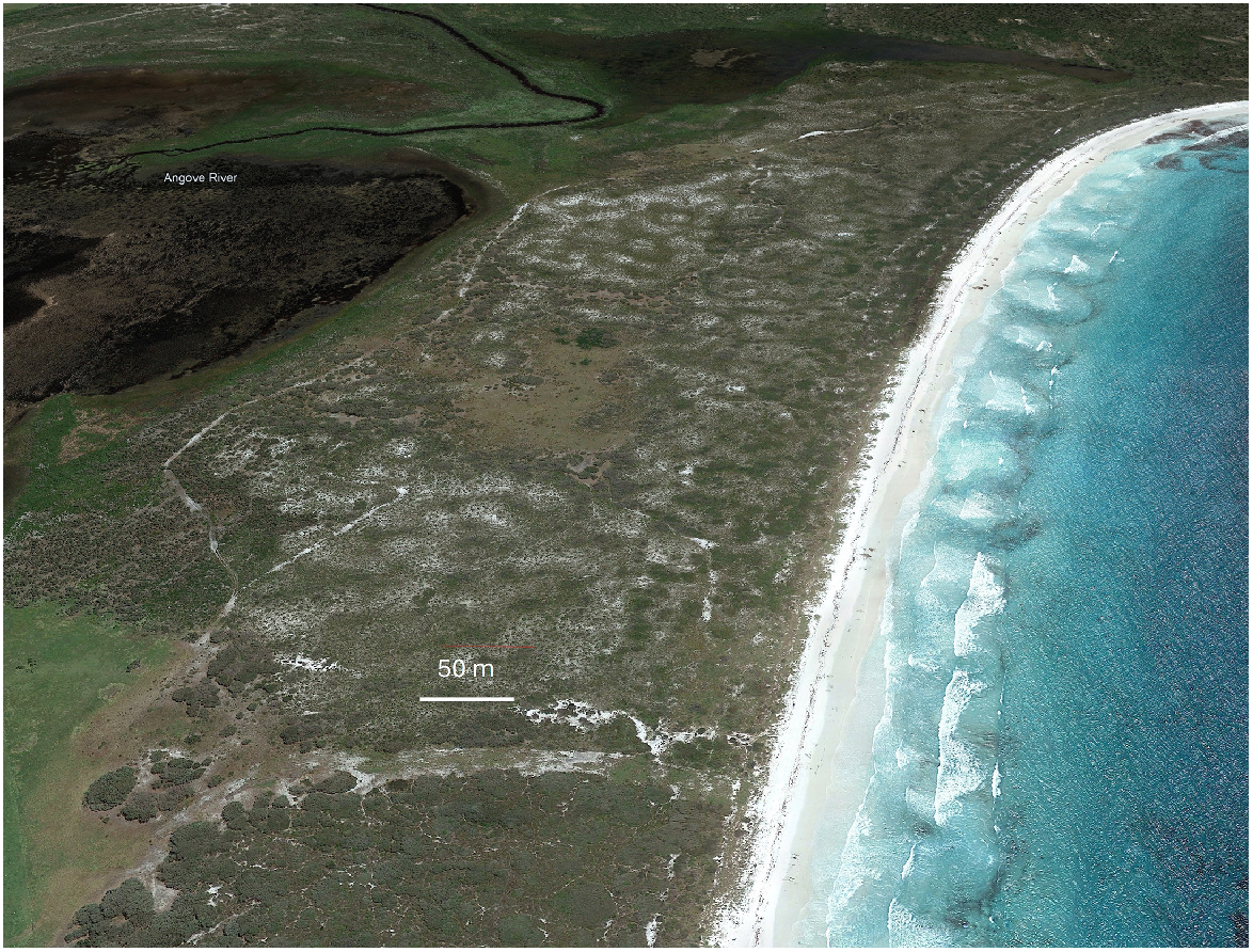
The width, volume, and development of the dune system diminishes to the south, where they are eventually replaced by relict foredunes and wetlands. This trend is also reflected in the distribution of wave and wind energy noted above. Decreasing wave energy results in a decrease in the transport of onshore wave-induced sediment and thus the net volume of sand delivered to the beach for dune building decreases (Short and Hesp 1982).
The decrease in wave energy and surf-zone width also has a marked effect on the foredune vegetation zonation and structure (Hesp 1988, 1991). As wave energy decreases, the degree of local salt spray and aeolian sand transport decreases and many salt-intolerant species can therefore grow closer to the beach. Thus, there is also a gradient in vegetation species zonation and structure. The pioneer and successive zones are widely separated and of limited richness in the northern and central areas, and closely spaced, richer, and more diverse in the southern section (Hopper et al. 2024).
Nornarup/Nanarup Beach to Rocky Point
Nornarup/Nanarup beach receives much higher energy waves than other beaches in the Reserve and is modally an intermediate (longshore bar-trough) or dissipative (linear, parallel bars and troughs) surf-zone system. Nornarup/Nanarup faces into the prevailing south and south-west swell, and breaker wave heights commonly exceed 3–4 m during storms.
The surf-zone is wide, and waves may break on the linear, carbonate reef lines that trend alongshore in the outer surf-zone/near-shore zone east of Rocky Point (Fig. 3). Beach mobility (the degree of erosion and accretion) is high, and both wave-induced and wind-induced sediment transport are high. The dominant winds are onshore and the net potential sand transport is directly onshore to obliquely onshore (Fig. 2).
Foredunes
In the Nornarup/Nanarup Bay region, foredunes are formed during periods of accretion and low–moderate wave activity, but are eroded regularly during storms. The erosion scarps are prone to wind attack and blowouts are common along the seaward edge of the dunes. Aeolian sand transport and salt spray inundation are much greater on this beach than on Two Peoples Bay and the vegetation zonation is generally wide, the pioneer zone being dominated by Spinifex. The vegetation zones are truncated by scarping, and in places locally disrupted because of blow-out and gully development (Figs 1 and 3).
Holocene dunes
Holocene dunes behind Nornarup/Nanarup Beach comprise extensive dunefields (Figs 1 and 3). They overlie older Pleistocene (10,000 1.8 million years BP) dunes and bedrock terrain, and are dominated by massive, vegetated, transgressive dunes, and one large, unvegetated, mobile transgressive dunefield (Tyiurrtyaalup/Moates dunefield) which abuts Kaiupgidjukgidj/Moates Lake. The dunes rise up to 60 m in some areas.
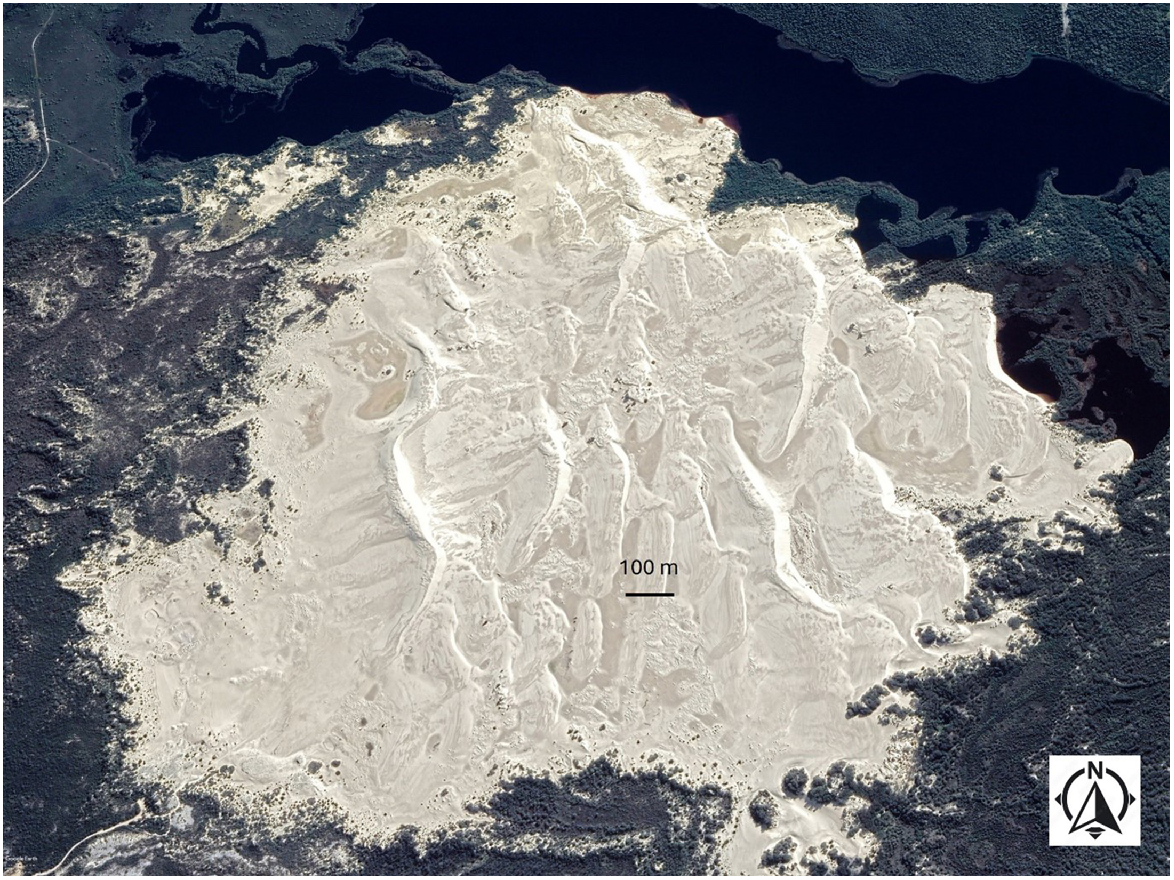
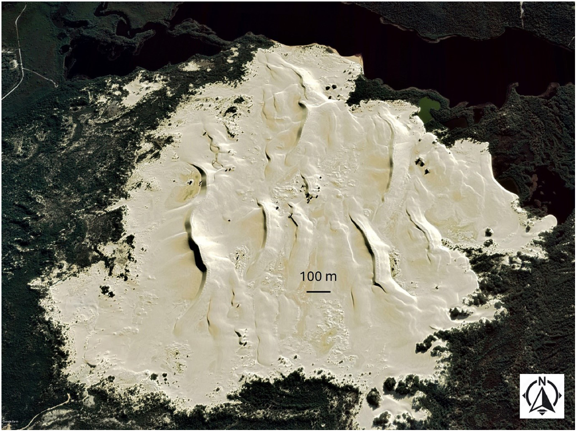
The active portion of the Tyiurrtyaalup/Moates dunefield comprises multiple sinuous transverse dunes and interdune flats and depressions (Fig. 6). The active transverse dunes generally migrate to the north-east under the influence of westerly to south-westerly winds, but at times strong north-easterly winds (Fig. 2) can result in slipface reversal of the dunes and they migrate to the south-west. Net migration of the dunefield is, however, to the north-east. Analysis from air photos of different age shows the active dunefield is migrating landwards at around 2.4–3.0 m/year. Fig. 6 illustrates the dunes at a time when their slipfaces were facing east-northeast, in contrast to Fig. 7, taken when they were facing west. As may be seen in Fig. 6, there are times when the interdune areas are significantly wet.
The Tyiurrtyaalup/Moates active transgressive dunefield in August 2018 showing the sinuous transverse dunes with slipfaces facing to the east. Source: Google Earth. Map data: Google, © 2020 CNES/Astrium, Maxar Technologies.
The Tyiurrtyaalup/Moates active transgressive dunefield in May 2022 showing the sinuous transverse dunes with slipfaces facing to the west. Source: Google Earth. Map data: Google, © 2020 CNES/Astrium, Maxar Technologies.
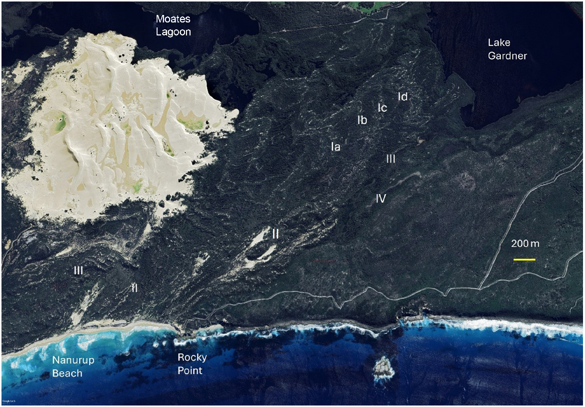
The largely vegetated portion of the Tyiurrtyaalup/Moates dunefield is a complex mix of parabolic dunes and transgressive dunefield (Fig. 7). The dunefield is characterised by intricate, short and long, crenate and digitate dune ridges (Ia–Id in Fig. 8) interspersed with deflation plains and basins. Parabolic dunes are evident in some portions of the dunefield (II in Fig. 8), and high, long precipitation ridges surround the dune system and exist within it (III in Fig. 8). Precipitation ridges are so called because they form by sand precipitating or raining down into vegetation (Cooper 1958). There have likely been multiple episodes or phases of dunefield formation over the Holocene, leading to the development of the multiple, arcuate, overlapping phases. Some examples of discrete dune phases are shown in Fig. 8 and labelled Ia to Id. These dune phases sometimes form overlapping or imbricate sequences with each younger phase being closer to the coast, but cannibalisation is also common in such dunefields and younger dune phases may have completely overrun older phases and incorporated most of their sediments into the younger phase. The dunefield landform units are therefore quite chaotic at times (cf. Semeniuk and Semeniuk 2011).
Part of the Holocene and Pleistocene dunefields in the Nanarup Beach region. The boundary between the Holocene and Pleistocene dunefields (the margin is indicated by IV) extends in a north-easterly direction from Rocky Point. Source: Google, © 2020 CNES/Astrium, Maxar Technologies.
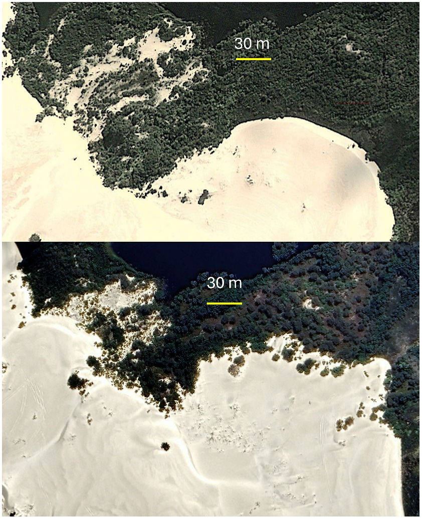
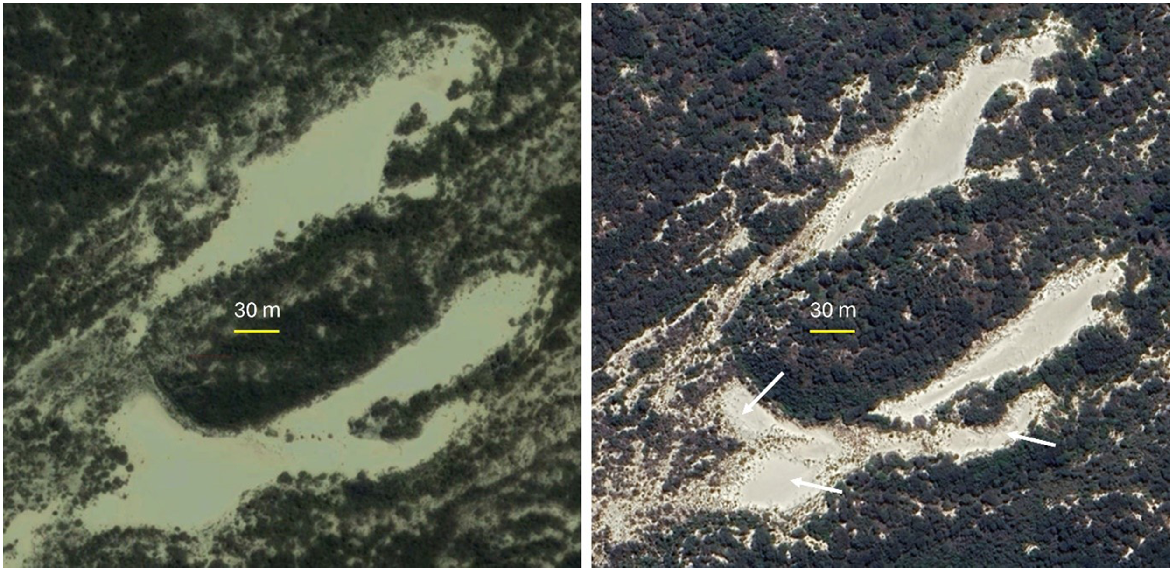
The sinuous, often crenate or digitate ridge patterns prevalent on the vegetated dune phases results from in-place stabilisation by vegetation of the edges of active dunefields (Hesp and Thom 1990; Toffani et al. 2024). Examples of how this occurs are shown in Figs 9 and 10. In Fig. 10 a formerly simple, arcuate, active slipface in 2004 has gradually been colonised by vegetation by 2023. The colonisation process is irregular alongshore resulting in portions that are well vegetated and portions which are not. The unvegetated portions advance landwards relative to the vegetated portions creating a highly crenate and/or digitate margin. As vegetation colonisation continues, this becomes more pronounced with the final fully vegetated ridge morphology being quite crenate. In Fig. 10, a complex suite of (semi-) parabolic dunes in 2010 have been colonised around all active margins by vegetation in 2023. This has resulted in a reduction in the area of active dunes, isolation of active portions from one another, and ridge building around the margins. Note that winds blow from westerly and easterly quadrants in this region (figs 2 and 4 in Williams et al. 2024), so winds capable of aeolian transport can blow from various directions to almost all corners of the active dunes. As the margins are colonised by vegetation, it is common for the active middle portions to continue to erode and blow-outs are often formed (Lopez and Hesp 2023; Toffani et al. 2024), resulting in a deepening of the active portion and an increase in the relative elevation of the surrounding ridges. Thus, Figs 9 and 10 illustrate how the complex vegetated dune ridges characterising the Holocene vegetated dunefield evolve from relatively simple active dunefields. Note that it is also common for transgressive dunefields to either stabilise as large-scale arcuate forms which mimic parabolic dune forms, but which are not actually parabolic dunes (see the arcuate ridge morphologies of Ia–Id in Fig. 8), or sometimes evolve into parabolic dunes in the last stages of dunefield stabilisation (Lopez and Hesp 2023; Hesp 2024).
The upper image is from October 2004, and the lower image from January 2023. Over the 19-year period, vegetation has begun to stabilise the active dunefield precipitation ridge forming a crenate marginal precipitation ridge morphology. Source Google Earth. Map data: Google, © 2020 CNES/Astrium, Maxar Technologies.
The left image is from September 2010 and the right image from January 2023. Over the 13-year period significant vegetation colonisation has occurred on all margins of the active parabolic and blow-out dunes (some examples arrowed) resulting in substantial temporal changes to the dunefield morphology. Source Google, © 2020 CNES/Astrium, Maxar Technologies.
Some of the oldest dunes may have formed as sea level was still rising in the latter part of the Post-glacial Marine Transgression, and may be as old as 10,000 years BP. This is not uncommon, for example, along the South Australian coast (Short 1988). The dune phases then likely continued to form throughout the last ~7000 years or so.
The Holocene dunes appear to overlie a formerly more extensive lake and estuarine system (Fig. 3), since Kaiupgidjukgidj/Moates Lake and Tyiurrtmiirity/Gardner Lake may possibly have constituted a larger single system in the past prior to transgression of the Holocene dunefield. The lakes were possibly linked to form an extensive estuary during the last Interglacial (c. 120,000 years BP), when sea level was around 5 m higher than present (Fig. 8).
Pleistocene dunes
The Pleistocene dunes have been lithified to form aeolian calcarenites. The dunes are all well vegetated and occur between the two bays discussed in this paper. They have been eroded to form cliffs along the seaward edge of the bay east of Rocky Point. The dunes reach up to ~60 m high above sea level in places. They were also formed as transgressive dune fields. Little is known of their age and the processes of emplacement in relation to position of sea level. However, the present cliff provides a strong indication that much of the surface terrain was formed during periods when sea level was lower than at present (rising or falling sea levels). Surface dune forms extend to the cliff edge, and dune sequences and palaeosols are visible in cliff exposures. Thus, some of the clifftop dune systems may have formed initially as climbing dunes which have then been stranded on clifftops following wave erosion of the basal beaches and associated climbing dunes. Certainly, in other parts of Australia, it is clear that transgressive dunefields have formed as sea level was falling post-Last Interglacial (e.g. the Robe region in South Australia; Hidayat et al. 2023), and as sea level was rising in the post-glacial late Pleistocene-Holocene transgression (e.g. South Australian south coast; Short et al. 2024). Thus, it is likely that the dune system of Nornarup/Nanarup comprises multiple stacking episodes of dune building throughout the Pleistocene high sea level events, but also possibly during falling and rising sea levels in pre- and post-high sea level periods. Some of the dunes may overlie bedrock, especially towards the eastern margin.
The pocket beaches
Three ‘pocket’ beaches are present within or near Two Peoples Bay Nature Reserve. Two lie immediately south-west of South Point (Little Beach and Waterfall Beach), and one immediately east of the northern end of Two Peoples Bay (Herring Bay) (Fig. 1). These beaches are reflective beaches. That is, the surf-zone is very narrow, and plunging to surging breakers break near the base of the beach, surge up the beach as accentuated swash and the return swash is reflected off the beach-face back out to sea (Fig. 11). The beaches have moderately steep gradients and display limited aeolian sand transport. Dune formation is restricted to minor incipient foredunes which are occasionally scarped by storm waves.
Conclusion
The beaches and dune systems of Holocene age comprise major geomorphic elements of Two Peoples Bay Reserve. They range in type from relatively high to low energy wave and wind energy systems and include all the major dune types present elsewhere along the Western Australian coast. They also represent a Quaternary sequence extending from at least the Last Interglacial (120,000 BP) transgressive dunes, Last Glacial (40,000–10,000 BP) cliff top parabolic and transgressive dunes, to Holocene (10,000 BP to present) parabolic dunes, transgressive dunes, and foredunes. The beach and dune systems are both dynamic and fragile and warrant sensitive management. Conservation and management of these beaches, dunes, and barrier systems in Two Peoples Bay Reserve is thus a continued priority, as they represent fine examples of natural coastal ecosystems in south-west Australia.
Data availability
Data sharing is not applicable as no new data were generated or analysed during this study.
Acknowledgements
Thanks to the West Australian Department of Agriculture for supporting my original work on the Two Peoples Bay region in 1985, and to Dr Denis Saunders for kindly reviving the original study. A special thanks to Andrew Gunn (Monash University) for provision of the Fryberger-Dean analysis and resultant utilised in Fig. 2. Thanks also to Emeritus Professor Bruce Thom, Dr Geoff Pickup, and Dr Denis Saunders for their considerable assistance with reviews of the manuscript.
References
Courrech du Pont S, Rubin DM, Narteau C, Lapôtre MGA, Day M, Claudin P, Livingstone I, Telfer MW, Radebaugh J, Gadal C, Gunn A, Hesp PA, Carpy S, Bristow CS, Baas ACW, Ewing RC, Wiggs GFS (2024) Complementary classifications of aeolian dunes based on morphology, dynamics, and fluid mechanics. Earth-Science Reviews 255, 104772.
| Crossref | Google Scholar |
Hesp P (1988) Surfzone, beach, and foredune interactions on the Australian south east coast. Journal of Coastal Research 3, 15-25.
| Google Scholar |
Hesp PA (1991) Ecological processes and plant adaptations on coastal dunes. Journal of Arid Environments 21, 165-191.
| Crossref | Google Scholar |
Hesp PA (2024) Coastal dunes: types, initiation, morphology, evolution, and relationships to surfzone-beach systems and climate. In ‘Treatise on estuarine and coastal science, vol. 2’. 2nd edn. (Eds D Baird, M Elliott) pp. 866–903. (Elsevier: Oxford). doi:10.1016/B978-0-323-90798-9.00074-3
Hesp PA, DaSilva M, Miot da Silva G, Bruce D, Keane R (2022) Review and direct evidence of transgressive aeolian sand sheet and dunefield initiation. Earth Surface Processes and Landforms 47(11), 2660-2675.
| Crossref | Google Scholar |
Hidayat R, Murray-Wallace CV, Jacobs Z (2023) Late Pleistocene evolution of Robe Range, southern Australia – the timing and carbonate source dynamics of coastal dune development. Marine Geology 456, 106987.
| Crossref | Google Scholar |
Hopper SD, Harvey JM, Hopkins AJM, Moore LA, Smith GT (2024) Plant diversity on the edge: floristics, phytogeography, fire responses, and plant conservation of Two Peoples Bay Nature Reserve in the context of OCBIL theory. Pacific Conservation Biology 30, PC24024.
| Crossref | Google Scholar |
Knapp L, Cummings D, Cummings S, Fiedler PL, Hopper SD (2024) A Merningar Bardok family’s Noongar oral history of Two Peoples Bay Nature Reserve and surrounds. Pacific Conservation Biology 30, PC24018.
| Crossref | Google Scholar |
Lopez ACB, Hesp PA (2023) Evolution of a coastal transgressive dunefield to a parabolic dunefield, Canunda dunes, South Australia. Geomorphology 430, 108653.
| Crossref | Google Scholar |
Miot da Silva G, Hesp P (2010) Coastline orientation, aeolian sediment transport and foredune and dunefield dynamics of Moçambique Beach, Southern Brazil. Geomorphology 120, 258-278.
| Crossref | Google Scholar |
Semeniuk CA, Semeniuk V (2011) Dune slacks in Western Australia. Journal of the Royal Society of Western Australia 94(4), 503-532.
| Google Scholar |
Short AD (1979) Three dimensional beach-stage model. The Journal of Geology 87(5), 553-571.
| Crossref | Google Scholar |
Short AD (1988) Response of a high through low energy sandy coast to sea-level transgression and stillstand, South Australia. Geographical Review 78, 119-136.
| Google Scholar |
Short AD, Hesp PA (1982) Wave, beach and dune interactions in southeastern Australia. Marine Geology 48, 259-284.
| Crossref | Google Scholar |
Short AD, Tamura T, Oliver TSN, Detmar S, Fotheringham D (2024) Quaternary clifftop and last glacial maximum dunes around the Great Australian Bight. Quaternary Science Reviews 327, 108517.
| Crossref | Google Scholar |
Toffani M, Hesp PA, Isla F, Casadío S (2024) Evolutionary stages of active to vegetated coastal transgressive dunefields in the San Matías Gulf Coast, Argentina. Geomorphology 461, GEOMOR-13231R1.
| Crossref | Google Scholar |
Williams AAE, Harvey JM, Hopper SD, Hopkins AJM (2024) A new vegetation classification for Western Australia’s Two Peoples Bay Nature Reserve and its significance for fire management. Pacific Conservation Biology 30 PC24036.
| Crossref | Google Scholar |


