
Revisions to the Australian tropical cyclone best track database
Joseph B. Courtney A C , Gary R. Foley B , Johannes L. van Burgel B , Blair Trewin A , Andrew D. Burton A , Jeffrey Callaghan B and Noel E. Davidson B
A Bureau of Meteorology, Australia.
B Formerly of Bureau of Meteorology.
C Corresponding author. Email: joe.courtney@bom.gov.au
Journal of Southern Hemisphere Earth Systems Science 71(2) 203-227 https://doi.org/10.1071/ES21011
Submitted: 19 May 2021 Accepted: 24 August 2021 Published: 30 September 2021
Journal Compilation © BoM 2021 Open Access CC BY-NC-ND
Abstract
The Australian tropical cyclone (TC) best track database (BT) maintained by the Bureau of Meteorology has records since 1909 of varying quality and completeness. Since 2005 a series of efforts to improve the database have included: removing internal inconsistencies, adding fixes, and identifying errors using comparisons with other datasets; upgrading intensity information since 1973 including adding maximum winds (Vm) prior to 1984–85, rederiving Dvorak Current Intensity numbers from archived material and accounting for different wind–pressure relationships used; a partial reanalysis of satellite imagery including microwave imagery using the HURSAT dataset since 1987; and considering an objective intensity dataset. The BT homogeneity is reviewed in the context of improvements in satellite technology, observational coverage, scientific developments, BT procedures and the subjective variation between analysts across time and offices. The scale of these variances is greatest in the early stages prior to 1981 in the absence of geostationary satellite imagery until 1978, satellite calibration issues from 1978–80 and prior to the introduction of the enhanced infra-red Dvorak technique in 1981. The current era since 2003 is considered to be the most accurate, comprehensive and homogeneous corresponding to the expansion of the TC database to include the current suite of fields; the application of microwave and scatterometry imagery; greater standardisation of BT practices and slight changes in the application of the Dvorak technique. These improvements have generated a more consistent dataset that could be used for weather and climate research and other TC-related work.
Keywords: tropical cyclone, best track database, historical reanalysis, Dvorak technique, satellite analysis, wind-pressure relationships
1 Introduction
The Australian tropical cyclone (TC) best track database (BT) has records since 1909 of varying quality and completeness (BoM 2021; Holland 1981; Trewin 2008). To address inhomogeneities and missing data, the Australian Bureau of Meteorology (BoM) has undertaken a series of revisions since 2005 to develop a more consistent and complete TC dataset in the Australian region (Fig. 1). This has been enabled by the expansion of the TC database format to add fields such as wind radii quadrants, Dvorak parameters and many metadata fields as described in the database specifications document (BoM 2021).

|
A significant component of this effort was to investigate the consistency of maximum winds (Vm) estimates and extend the record prior to 1984–85. The Dvorak satellite analysis method (Dvorak 1973, 1975, 1984) was first applied in the Australian region in 1973 and remains the primary tool for determining the TC intensity. Remarkably, there have been only relatively minor refinements to the technique, especially since the enhanced infra-red (EIR) method was introduced in the early 1980s. While the Dvorak Current Intensity (CI) metric has been relatively stable in its derivation, the corresponding set of Vm and central pressure (CP) estimates has been quite varied over the Australian region due to different approaches and use of different wind-pressure relationships (WPRs) being employed across the three historical Tropical Cyclone Warning Centres (TCWCs) in Darwin, Brisbane and Perth. This has made it difficult to use the data temporally in any homogeneous way (see Harper (2002) for examples and discussion of WPR variations across and within TCWCs). Courtney and Knaff (2009) described the current Australian standard WPR, hereafter referred to as the Courtney-Knaff-Zehr relationship (CKZ). Table 1 summarises the changes and advances made over the satellite era.

|
Reanalysis efforts can be described in the following projects that were conducted over the years indicated below:
2005–07: corrections for internal inconsistencies and comparisons with external datasets for significant differences, gross error checks and duplicate tracks (Trewin 2008).
2006–12: database repair project to investigate TC intensity (1973–2002) using historical records: Foley (2012), van Burgel (2012), Callaghan (2013) and unpublished work by the lead author.
2015–19: reanalyses using the Hurricane Satellite (HURSAT) archive, especially microwave imagery, with emphasis on initial TC intensity and peak intensity for previously identified cases of interest: unpublished work by the lead author.
2016–19: review of structure parameters and application of objective techniques (Advanced Dvorak Technique (ADT) and various structure datasets) to analyse database completeness and homogeneity: Courtney and Burton (2018) and unpublished work by the lead author.
These projects are expanded on in the sections that follow.
2 Internal inconsistencies and comparisons with external datasets (2005–07)
The reanalysis work done in 2005–07 (Trewin 2008) focussed on internal inconsistencies and comparisons with external datasets and included:
Checks for excessively rapid or irregular movement
Observations at irregular times outside standard synoptic times
Consistency between CP and wind speed where both were available
A test was also carried out for potential duplicate systems.
The BT was compared to the following datasets and information sources:
Joint Typhoon Warning Center (JTWC) dataset (covering 1945–46 to 1999–2000)
BoM regional datasets held at Queensland (Qld) and Northern Territory (NT) State offices
A reanalysis of TCs in northwest Australia carried out on behalf of Woodside Energy (Harper et al. 2008)
The published and working notes of Lourensz (1981)
Seasonal summaries, either published as standalone documents or in the Australian Meteorological Magazine (covering 1957–58 to 2003–04, except for 1972–78 and 1992–93)
Operational charts and archived TC documents.
Some amendments could be attributed to data entry errors in position or intensity. For example, a longitude of 125.8°E amended from 128.5°E (Gertie 1985). More significantly, a number of new systems were included that appeared to be omitted from the BT record by mistake, such as Doris (1980) and Harold (1997). Tina (1990) was named operationally but not included originally in the BT because it was regarded as a monsoonal low but was reinstated as a TC with comments on its monsoon-like characteristics. An unnamed system in 1980 (197 980_15U) was added, as it was included in Lourensz (1981) and also on the JTWC archive, suggesting it likely reached TC intensity. This was confirmed by a subsequent review of HURSAT data. Another addition was the unnamed TC that devastated the Indonesian island of Flores in April 1973 (197 273_15U); data was retrieved from NT archives and reanalysed during the ‘Woodside’ reanalysis.
Particular attention was given to a number of systems in the JTWC dataset, mostly between 1945 and 1960. The majority of these systems were near the boundaries of Australia’s current area of responsibility, especially in the west. At the time, Australia did not systematically report on or issue warnings for cyclones west of 105°E. For example, Gina (1968) combines BoM data east of 105°E with JTWC data west of 105°E. The JTWC dataset at that time had no intensity indicators, and assumptions therefore had to be made about whether a system was likely to have reached cyclone intensity within the Australian region based on its lifetime and the behaviour of more recent systems in the JTWC database. JTWC systems without other supporting information were included if they met the following criteria:
A lifetime of at least 36 hours
Did not leave the Australian region within 24 hours of formation
Not in close proximity to the coast (it is assumed that near-coastal systems would already have been considered).
For most of these systems it will be impossible to determine definitively whether or not they reached TC intensity, but it is qualitatively estimated that the systems included have at least a 50% probability of having reached TC intensity. This will partially address the negative bias in pre-1970 cyclone numbers over the far western parts of the Australian region, although it is likely that many systems were still missed.
Some systems were also deleted, including some that were not over the ocean at any time during their lifetime, some where the working note of Lourensz indicated that he did not consider these systems to have reached cyclone intensity and some that were outside the Australian region. Others were merged if they were deemed to be duplicates or if they could be analysed as a continuous system. In some cases, this required amending the names (either by merging names or deleting a name), such as Beverley-Eva, Fiona-Gwenda and Doris-Gloria. Some names were added for TCs that entered the region from the Pacific in the late 1950s and early 1960s (Agnes, 195 556_13U, Bertha, 195 859_04U, Beatrice 195 859_05U, Connie 195 859_08U, and Annie 196 263_04U) before routine naming of systems in the Australian region began in the 1963-64 season.
In general, this process did not reassess intensity, except for a few cases where internal consistency checks revealed clear errors or where an individual cyclone had been reassessed by the relevant region (e.g. Pam 1974 peak CP changed from 970 to 925 hPa). Appendix 1 lists some of the more significant changes during this process.
While the database mostly contains fixes at the standard 00, 06, 12 and 18 UTC times, from the 1995-96 season in the western region, fixes were at 01, 07, 13 and 19 UTC, and then, from 1997, this changed to 04, 10, 16 and 22 UTC until being standardised from the 2001–02 season. The addition of the standard fix times was flagged for future consideration.
3 Revision of intensity based upon historical documentation and interpretation of practices (2006–12)
From approximately 2006 to 2012, a ‘database repair’ project investigated TCs between 1973 and 2002 to provide a complete dataset of Vm and Dvorak CI estimates: Foley (2012), van Burgel (2012), Callaghan (2013) and unpublished work by the lead author. Previously the only comprehensive gauge of TC intensity over the Australian region had been the CP value, but these estimates are inhomogeneous owing to the application of different WPRs. The maximum 10-min mean wind had been included in the database progressively since around 1984, but for a period in the 1980s, some estimates had been incorrectly derived from CI estimates. Comparisons with overseas datasets from JTWC and neighbouring TCWCs were conducted.
3.1 Application of the Dvorak technique
The Dvorak method is used globally for estimation of TC intensity, including the Atlantic basin where aircraft reconnaissance is conducted and the technique is used and validated. Briefly determining the intensity involves:
Analysing the cloud patterns in infra-red (IR) and visible imagery via a flowchart of decision points to determine the Dvorak term the Final T-number (FT) and then apply rules to determine the term CI number, as described in Dvorak (1984).
The CI number is then used to obtain a value of Vm via a look-up table relating the two quantities.
The final Vm can be adjusted from the Dvorak according to other inputs, such as surface observations, scatterometry, microwave patterns and objective estimates, such as ADT (Olander and Velden 2019) and SATCON (Velden and Herndon 2020), as summarised in appendix 1 of Courtney and Burton (2020). However, in the Australian region, it is rare that surface observations influence the intensity estimate, and scatterometry, microwave and objective techniques have only been available since the early 2000s, so for TCs from 1973 to the early 2000s, the Dvorak technique was the only method to estimate the intensity in the absence of observations. Deviations from Dvorak are more likely near landfall when there is a greater chance of observations and impact assessments.
To obtain the CP, a WPR is applied.
Key issues are the quality of Dvorak estimates and the consistency in its application through time and between analysts. It is truly remarkable and valuable that the Dvorak technique has worked so well for so long. For the Australian region, because of the very few conventional observations to validate the technique, application of the method has been based on validation from the Atlantic, where the deployment of superior observational platforms provides some ground truth.
Reviews of the technique and its strengths and weaknesses are found in Burton (2005), Velden et al. (2006) and Knaff et al. (2010). The latter study validated Dvorak intensity estimates in the North Atlantic against BT data where aircraft reconnaissance data were available, confirming the accuracy of the technique and noting ‘the Dvorak technique has a tendency to slightly underestimate intensities of storms receiving CI estimates ranging from 2.5 to 3.5 by an average of 1.5–2.5 kn,1 overestimate intensities of storms receiving CI estimate ranging from 4.5 to 5.5 by 1.5–2.5 kn, and underestimate intensity estimates of storms receiving CIs ranging from 6.5 to 7.0 by 4–9 kn.’
While it is not possible to be definitive about biases in the technique in the Australian region, a comparison of BT and the ADT during the objective reanalysis study discussed in section 5 (Courtney et al. 2020), remarkably showed there was just a 0.2 kn bias for the 2003–16 era.
Over the years, the process to determine the Dvorak CI (step 1) has remained generally constant, although differences in applying the Dvorak technique were later addressed during the objective reanalysis project discussed further in section 5.
Being an inherently subjective process, there are many reasons for variations in CI estimation throughout the historical record. Despite this the robustness of the technique has afforded it widespread acceptability in lieu of direct measurement.
Intensities are resolved at 5 kn intervals so that a single CI estimate can match multiple Vm alternatives, allowing the analyst to apply discretion. For example, a ‘weak’ CI of 4.5 could be matched to 65 kn while a ‘strong’ 4.5 could be allocated to 75 kn, and generally, the intensity trend is smoothed between fixes.
However, there are some examples that seem to indicate some discrepancies at the intense end of the scale. Comments in the TC Aivu (1989) report (BoM 1990) indicated that a CI of 6.5 corresponded to a pressure of 935 hPa, but the BT winds at that time were just 95 kn. This happened again during TC Rewa (1993–94) when a pressure of 920 hPa matched 90–95 kn on 2–3 January, even though the report indicated 110 kn; although, for the second intensity peak on 16 January, 920 hPa was matched with 110 kn in the BT. Such deviations may have been the result of interpretations of observations but there is insufficient detail even in the reports. For both Aivu and Rewa, the intensity was adjusted to 110 kn following reanalysis.
Occasionally, the availability of observations appears to have influenced the Dvorak estimate, at odds with the ‘pure’ satellite nature of Dvorak. For example, for TC Justin (1997), a large system, the initial operational Dvorak estimates were as high as 3.5–4.0 with a remark ‘primarily from observations’. A reanalysis of imagery suggested that Dvorak values during this period were 2.5–3.0.
3.2 Situations where the Dvorak method is invalid
There are situations where Dvorak is not valid or unreliable, and this reinforces the fact that even re-engineered CI numbers could not be applied blindly to the Australian TC database simply based on CP or Vm values. This applies to the following situations:
Over land, either during the development stages before moving over water or after making landfall and weakening. Dvorak is not generally applied during overland trajectories, although the Dvorak estimate is often still considered in the absence of other information in the hours following landfall or when the track remains close to the coast.
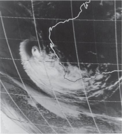
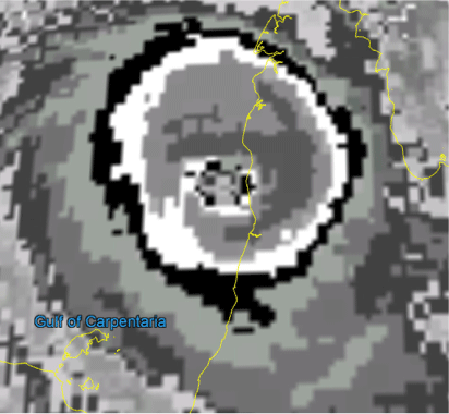
Moving outside the tropics and losing their tropical cloud characteristics. Dvorak will underestimate the intensity and is not applicable for most sub-tropical systems or systems undergoing extra-tropical transition (ETT), such as TC Alby, 1978 (Fig. 2), documented in Foley and Hanstrum (1994).
Monsoonal systems exhibit fundamentally different characteristics to TCs in their dynamics, structure and cloud signatures, yet they can generate gale (34 kn) to storm-force (48 kn) winds. These can be included in the Australian record even though Dvorak does not strictly accommodate such a genre.
Strong synoptic forcing can result in higher winds than Dvorak suggests, particularly during formation and when moving south towards the sub-tropics, associated either with a strong monsoon to the north or a strong ridge to the south. Both of these features occurred during Kelvin (1991) in the Coral Sea, and while the maximum CI was 3.0, Willis Island recorded Vm to 65 kn. Estimated winds were at least 55 kn for an extended period from 25 to 27 February and again on 3–4 March. Observations, particularly scatterometry since 2001, can support BT Vm being higher than the associated Dvorak CI value, but the situation is more ambiguous in the absence of such observations. Historically, Dvorak remained the primary metric, but on some occasions some allowance is made so the Vm is higher than the CI. For example, Betsy and Daman (1992) were both large systems that were estimated to remain at 60 kn intensity even though the CI fell to 3.5 as they moved south and eventually transitioned into the mid-latitudes.
Eyewall replacement cycles (ERC). Dvorak estimates in general do not resolve such changes in the eyewall that are best viewed through microwave imagery, as discussed in Sitkowski et al. (2011).
|
The database fields cyc_type and max_wind_spd_method (BoM 2021) allows for these cases to be identified, and values have been added to the record since 1973 during the reanalysis process.
3.3 WPRs
The relationship between CI and Vm (step 2) has not changed since Dvorak (1975), other than a transition from 1 to 10-min wind conversion factors and some rounding issues. However, the practice during the early years was to arrive at the CP, and the CI and Vm values were not always saved. Furthermore, the WPR applied varied and was revised for each region to reflect experiences. Table 2 shows the range of WPRs used in the Australian region since the introduction of the Dvorak technique, as discussed in detail in Harper (2002).

|
While all regions initially applied Dvorak 1973 and then 1975 WPRs, the western region adopted the Atkinson and Holliday method (A&H) from Emma (1984) onwards; the northern region applied a local version from 1985, L&M, after Love and Murphy (1985), on the basis that the region has cyclones on the smaller end of the size distribution and have relatively high CPs; while the eastern region adopted their local WPR in 1984. The latter had two scales for ‘normal’ and ‘small’ TCs, the normal being somewhat similar to A&H whereas the small are more like Love and Murphy (1985). The different methods are a significant factor in the inconsistencies in the TC record.
As a result, although the base Dvorak technique was providing consistent estimates, the diagnosed values of Vm and CP were often lost or inconsistent. It is this inconsistency in the TC record that has been reviewed and repaired, as summarised by Foley (2012) and van Burgel (2012). The WPR for each TC was scrutinised, which uncovered many variants from that described above. For a period from 1976–77 to 1977–78 in the western region, the mid-point of the northwest Pacific and Atlantic was used, except for Trudy, Vern and Alby.
The original Dvorak CI to wind relationship used a 1-min mean wind. As noted by Harper (2002), a conversion factor of 0.88 was applied to correct to the Australian and World Meteorological Organization standards 10-min Vm. When winds began to be reported in the TC database from around 1984, it appears that the western region used 1-min winds instead of 10-min winds. The most likely cause would be from translating Dvorak CI numbers using a 1-min wind table from Dvorak’s guidance material. This gave around a 10% positive bias in wind values from 1984 to nearly 1992, with some exceptions. All these Vm estimates were corrected with appropriate checks for extra information considerations.
3.4 BoM intensity records and Dvorak archives
The task was to provide a complete dataset of Vm and Dvorak CI estimates from 1973 to 2002. Rather than perform a complete reanalysis of all TCs from satellite imagery, the approach was to build on the skill found in the original estimates and then consider the exceptions and inconsistencies detected. This is based on the knowledge that the Dvorak technique has been applied assiduously and skilfully during the post-event BT analysis by all three TCWCs and upon the premise that the application of the technique has been consistent throughout the record, as discussed in the previous section.
However, CI data were not incorporated into the BT until 2003 nor were they routinely stored in a digital archive. The retrieval of these CI data involved a search through archives in the different states in order to glean information, looking not only for the operational and BT Dvorak ‘worksheets’ that were a part of the determination process but also any evidence of what WPR and Dvorak tables were being used for in a given season in each TCWC.
A total of 352 TC over the entire Australian region contained in the database between 1973 and 2002 were reviewed. This period encompasses the most volatility in respect of WPR for all TCWCs (see Table 1).
Of the 212 TCs identified in the western region record between 1973 and 2002, the search revealed 102 cyclones where BT CI or FT data were retained in the archive. There are subtle differences imposed by Dvorak between CI and FT values in respect of the intensity of a TC, particularly during weakening, which required consideration.
Another 20 cases were found where the Working Track (WT) worksheets only were available. While these Dvorak operational worksheets are useful as a guide to the intensity of the TC, they do not constitute the final BT version, as some significant adjustments can be and were made in the post-event analysis. Therefore, WT-CI numbers cannot be related directly to the TC CP found in the database. The remaining 90 TC archived cases in the western region dataset that were examined revealed no readily locatable record of Dvorak data.
Similar searches of the BOM archives in Darwin and Brisbane yielded reasonable results. For the 38 northern region cyclones, 10 BT intensity analyses were located, eight cases had no Dvorak data and the remainder offered operational Dvorak material of variable quality. As a lot of northern region cyclones form very close to land and have short life spans, a number of operational sheets only contained sparse data entries. The Brisbane archive had data for all but 19 of the 110 cyclones. The majority were operational intensity estimates, but nine were BT estimates, mostly in the early days of Dvorak when CI or FT were tabulated in official summary reports. In lieu of no local Dvorak data being identified, Satellite Bulletins from the US JTWC or NOAA Satellite Services Division were noted as an additional guide if they were available.
While it has been fruitful to collect these Dvorak data, it became apparent that merely finding the CI or FT values in the archive and simply applying them directly to the database would not be the most appropriate or encompassing approach because of the different WPRs being used. A ‘reverse-engineering’ approach was proposed where the CIs are regenerated by applying the known Dvorak relationship used in the TCWC to the CPs given in the archive. Examination of CPs in the database (and after about 1984 supplemented with Vm values) was used to identify the key pressure values that corresponded the post-analysis BT CI number (Table 3). This gave confidence that TCs with no locatable archived Dvorak data can also be reverse-engineered to derive a relevant set of CI numbers given that the relationships used to derive those values are known.

|
All TCs in the Australian region dataset were processed in this manner. The key pressure values – points of correspondence between CP and/or Vm and CI number according to the Dvorak table being used – were identified for each TC and the dataset was then interpolated to obtain the CI numbers at each time step in the cyclone’s history (Table 4). Once this was in place, the prescribed Vm values could be documented.

|
Although observational data is traditionally sparse over the area where TCs occur, occasions do arise when the intensity estimate is influenced by a surface observation. The database field max_wnd_spd_method (BoM 2021) allows for these cases to be identified. For the majority of cases, this field will be ‘Dvorak estimate’ but could also be land estimate or derived from pressure measurement, for example.
3.5 Track additions and corrections and comparisons with other databases
While the initial review done in 2005–07 used different datasets to make additions and corrections, the database repair process made further alterations. About 15 TCs had major portions of their track added in sections of at least 6-hourly frequency. Examples were the sub-tropical phase of TC Herbie (1988), which impacted the Shark Bay area of Western Australia, and TC Hector (1986) and TC Jason (1987) where the missing northern region sections were located and inserted. Some TCs abruptly commenced when they were near TC intensity already, so fixes were added to better describe the origins.
Further typographic and systemic issues were addressed. For example, some winds erroneously mixed ms-1 with kn, such as Steve (2000) in the northern region.
Comparisons with other datasets identified cases warranting particular attention using the methodology described in the following sections. As mentioned earlier, the revised BT was compared with theJTWC archive and the 2002 reanalysis study for western region TCs performed on behalf of Woodside by ex-BoM meteorologists (Harper et al. 2008). A consistency check against these two datasets highlighted exceptions that were investigated. Table 3 of the Woodside report documented 35 cases when their CI numbers differed from the derived CI in the BT (as of 2000) by more than 0.5. Following the database repair process, this number reduced to 13 and then further to just three by the end of the reanalysis, as discussed in section 4.
For some, such as Alex (1990), the reanalysed BT agreed with Woodside, and for many others the final CI was somewhere between the earlier BT and Woodside, whereas for others the earlier BT was supported.
There were only three events (Maud 1973, Linda 1976 and Carol 1980) where the difference was 1.0 or more. BT winds for both Maud and Linda were estimated higher than the original CI of 2.5 would suggest, but the imagery was not available to review. For Carol, reanalysis of the imagery supports the BT CI estimate of 6.5 over the Woodside value of 5.5. TC Tina (1990) was categorised as a monsoonal system without any BT CI estimates even though the Woodside CI was estimated at 4.0.
The JTWC dataset (in conjunction with the Neumann reanalysis set) as well as those areas of intersection with the La Reunion Regional Specialised Meteorological Centre’s (RSMC) database in the western region and RSMC Wellington in the eastern region can be compared using the US National Climate Data Center International Best Track Archive for Climate Stewardship (IBTrACS) website (Knapp et al. 2010), although it must be remembered that JTWC use a standard of 1-min mean wind compared with the BoM 10-min mean wind and does not provide CP values. CP is used by RSMC’s Wellington and La Reunion and in the Neumann reanalysis set as the principal intensity metric.
The IBTrACS site lists the 25 TCs in each basin with the largest deviations or ‘disagreements’ between contributing agencies for the same TC. For the South Indian Ocean, there were eight TCs that occurred after 1973. JTWC winds were less than the BT for Hazel (1979), Amy (1980), Fred (1980) and Jacob (1985), and reanalysis mostly confirm BT, especially as Hazel and Amy both had documented land impacts. Jacob was updated upon reanalysis and is now consistent with JTWC. The upgraded BT winds are also within tolerance with JTWC for Leon (1989) and Jane (1992), whereas for Idylle (1973) and Annette (1984), the differences are with La Reunion and well west of 90°E outside the Australian region and were not investigated.
Similarly, in the South Pacific Basin, only five TCs were listed in the top 25 differences after 1973 and within the Australian region. Two of these (Kerry and Rosa, 1979) were well scrutinised at the time, having National Oceanic and Atmospheric Administration (NOAA) aircraft reconnaissance data, suggesting that the BT should have significant credibility. Elinor (1983) was reanalysed to be similar to RSMC Wellington at peak intensity.
The other two TCs, Simon (1980) and Harry (1989), continue to have significant points of difference between agencies. TC Simon (1980) was analysed as a more intense cyclone on 25 February by RSMC Wellington (930 hPa) than either BoM (reanalysed at 85 kn) or JTWC (75 kn). While the imagery would support the BT, there is sufficient ambiguity in the observations not to discount a higher intensity. Observations included Heron Island (70 kn on 25 and 26 February), Sandy Cape Lighthouse: (75 kn at 00 UTC 27 February) and ship ‘Poolta’ off Fraser Island (100 kn at 00 UTC 27 February) but of unknown quality. TC Harry (1989) was held at its most intense by RSMC Wellington (lowest CP 925 hPa), which is longer than BoM or JTWC, but reanalysis confirms weakening. The reanalysis also increases peak intensity from 100 to 110 kn, closer to JTWC’s peak of 117 kn (when converted to 10-min wind).
4 Reanalysis using the HURSAT archive and collation of case studies not previously included in the database
In reviewing the outcomes of the previous projects, it was clear that some TCs warranted extra attention. The HURSAT satellite archive (Knapp and Kossin 2007) provided Advanced Very High Resolution Radiometer (AVHRR) and Geostationary Meteorological Satellite (GMS) imagery from 1978 as well as microwave imagery (Special Sensor Microwave Imager (SSMI) from 1988 and Tropical Rainfall Measuring Mission (TRMM) from 1998) that was not considered in the BT process until about 1999 when NRL provided operational access via their website. Fig. 3 is an example of the 37 GHz and 85 GHz SSMI microwave imagery alongside a visible image for Barisaona (1988) that was used to increase the intensity. Callaghan (2013) selectively reanalysed notable parts of 31 TCs in the eastern and northern regions. Results from a more comprehensive reanalysis of TC Tracy by Courtney and Shepherd (2010) were also incorporated. Adjustments to the BT were made on the basis of these investigations.

|
The findings from previous reviews and reanalyses meant that all TCs in the HURSAT era could be reviewed by the lead author. This process resulted in substantial changes to the intensity and extra fixes being added. Appendix 2 is a summary of selected reanalysed Vm estimates, and Appendix 3 has extended descriptions for a smaller selection: Pam (1974), Tracy (1974), Trixie (1975), Dominic (1982), Elinor (1983), Kathy (1984), Jacob (1985), Barisaona (1988), Orson (1989), Felicity (1989), Kelvin (1991), Neville (1992), Rewa (1993–94) and Rosita (2000).
Overall, the changes mostly resulted in an increase to the intensity. Those cases having a notable increase in peak intensity include Ivor (1990; 55–90 kn at landfall); Barisaona (1988; 30–60 kn); Neville (1992; 80–110kn); Rewa (1993–94; 80–110 kn on first peak); Nina (1992; 60–80 kn at Cape York landfall); Aivu (1989; 95–110 kn); Rosita (2000; 100–120 kn at landfall), Dominic (1982; 90–115 kn at landfall) and Felicity (1989; 50–75 kn). The cases of Winifred (1986; 70–85kn; BoM 1986), Aivu (BoM 1990) and Rosita (2000) underwent particular scrutiny given they were heavily studied at the time with official reports issued. Several events were revised to commence TC intensity at an earlier stage, notably Barisaona (1988), Kelvin (1991), Neville (1992) and Theodore (1994), and all three required earlier fixes to be added.
Microwave imagery permitted the detection of ERC, which typically resulted in an initial increase in winds but then a reduction of winds when the secondary eyewall dominated. Notable cases included Esau (1992), Drena (1997), Thelma (1998) and Vance (1999). Microwave imagery was instrumental in discerning intensity characteristics during Dvorak covered centre patterns, which often resulted in many previous analyses of CI of 5.0 being reduced. For example, Jacob (1985) was held too high at 5.0 for too long as was a tendency during the 1980s after the adoption of the
EIR technique. During this process winds were often reduced during weakening phases owing to the change in the Dvorak weakening rule to use 6 h instead of 12 h for holding the intensity higher.
Courtney et al. (2020) details the intensity decreases from the application of the Dvorak covered centre patterns, especially during the 1980s, and the change in the weakening rule.
As noted earlier, cyclones for much of the 1970s were named when the CI reached 2.5 based on the application of the 1-min wind Dvorak relationship. Each of the seven cases (Paula (1973), Natalie (1973), Maud (1973), Wanda (1974), Linda (1976), Lily (1977) and Nancy (1977)) were investigated in detail. Aside from the reasons of infrequent satellite passes, for all of these events, there are valid reasons to indicate gales were present either because of observations and/or synoptic forcing. In some cases, it is possible that gales may not have extended more than halfway around the centre, such as for Lily and Nancy in 1977.
In addition, Ernie (1989) in the Coral Sea was reanalysed to have failed to reach a CI of 3.0, and there were no observations available to support TC intensity. However, the reanalysis concluded that it was possible that gales occurred around the system for a 24-h period to justify TC status.
TC Pam (1974) was downgraded from 110 kn (CI = 6.5) to 105 kn (CI = 6.0) upon reanalysis as described in Appendix 3.
5 The Objective Tropical Cyclone Reanalysis Project (2016–19)
The Objective Tropical Cyclone Reanalysis (OTCR) project (Courtney and Burton 2018; Courtney et al. 2020) aimed to produce a homogeneous TC dataset by applying the ADT to IR imagery for all Australian TCs between 1981 and 2016. The ADT was run in two modes: (1) incorporating passive microwave imagery (PMW), which is the current operational mode and (2) without PMW given that it only became available in the 1990s. Comparisons of the ADT with PMW and BT for the most accurate BT era between 2003 and 2016 showed that the bias was just 0.2 kn, thereby providing confidence in the ADT dataset. Differences of at least 20 kn identified in 12 events during this period and were investigated further. In all but two of these cases, observational and microwave imagery supported the BT. For the other two cases, Fay and Wati, the BT winds were shown to be too high during weakening phases based upon a re-examination of satellite imagery and applying the Dvorak 6-h weakening rule.
Upon further analysis of the ADT without PMW, a series of adjustment rules were incorporated to address shortcomings of the dataset and to cater for handling missing images in the 1980s, as described in Courtney and Burton (2018). Following these adjustments, there remained 30 cases (1981–2016) having differences of at least 30 kn. These cases have since been investigated in response to the project’s recommendations. For 11 of these (Fran (1992), Nina (1993), Katrina (1998), Chris (2002), Larry (2006), Floyd (2006), Glenda (2006), Hamish (2009), Ului (2010), Kate (2014) and Quang (2015)), a reanalysis of HURSAT imagery supported the higher BT winds. For many of these cases, ADT did not sufficiently resolve the eye pattern, sometimes during rapid intensification.
For seven cases (Elinor (1983), Lance (1984), Felicity (1989), Kelvin (1991), Betsy (1992), Justin (1997) and Dylan (2014)), the BT Vm was higher than satellite imagery suggested because of synoptic enhancement, which was supported by observational evidence, particularly in the Coral Sea.
For seven cases (Neil (1981), Paddy (1981), Naomi (1983), Isobel (1985), Victor (1986), Kay (1987) and Cathy (1998)), the BT Vm was amended to be lower, mostly during weakening. This may be partly attributed to a conservative weakening approach, which was most evident in the 1980s.
For five cases where the BT Vm was lower (Bernie (1982), Jane (1983), Polly (1993), Sharon (1994) and Norman (2000)), a reanalysis using HURSAT indicated that the BT Vm required amending to be higher based on the combination of microwave patterns and revised Dvorak classification. The revised Dvorak CI was determined to be higher in the intensifying period for Bernie and Jane, whereas for Polly, microwave imagery resolved the contraction of an eye that was not identifiable on IR or visible (Vis) imagery.
The OTCR project also recommended the systematic application of the early microwave data to the BT Vm, which has mostly been achieved using the HURSAT dataset. This study also raised the possibility that the BT may have a high bias for the 1981–2003 era because of the application of the 12-h weakening rule that was adjusted to just 6 h from about 2003 and recommended. This has since been addressed for the above cases having major differences, but it is noted that most of those changes were quite minor on the order of 5–10 kn for short periods.
The OTCR project concluded that the BT intensity from 2003 onwards is the highest quality dataset, while users requiring a longer homogeneous record could use the adjusted ADT dataset from 1989 to 2016.
6 Other parameters
The major focus of reanalysis efforts has been on intensity (Vm and CI), however other parameters were also considered to different extents. The following database fields were completed during the final reanalysis process: surface_code, cyc_type, max_wind_spd_method and the comments field when appropriate. Other fields, such as wind gust, were partially inserted (BoM, 2021). The OTCR project examined wind radii (radius of gales (R34), storm-force (R48) and hurricane-force (R64)), CP, radius of maximum winds (RMW), environmental pressure (Pe) and radius of outermost closed isobar (ROCI).
6.1 Wind radii
The BT includes R34, R48 and R64 winds by quadrants (NE, SE, SW and NW). Values have been routinely included since 2003, with some early exceptions. Aside from infrequently available surface observations, gale radii were determined by scatterometry supported by microwave, Vis and IR imagery. QuickSCAT (QSCAT) imagery was only incorporated into the BT process in 2001 and ASCAT commenced in November 2007.
Earlier wind radii estimates were heavily biased towards available surface observations, including ship observations and otherwise inferred from cloud patterns and extent in IR imagery. The first values of R34 in the BT occurred in the 1984–85 season in the western region and initially on an opportunity basis when a surface observation was available, but then it was used more regularly from about 1988.
The early data has some very large values that included synoptically enhanced gales not directly associated with the TC circulation and were biased to use with general values, such as 60, 90, 120 and 150 nm. A comparison of the two eras shows a reduction in R34 estimates from 173 km (pre-2001) to ~140 km when scatterometry and microwave was available. The decrease agrees with anecdotal evidence from analysts who conducted BT in both eras. The recent average is consistent with the study using QSCAT imagery from 1999 to 2009 (J. C. L. Chan pers. comm. 2018) that found the average gale radius in the Australian region was 145 km.
While some historical data has been updated on an ad hoc basis during the reanalysis period, there has been no systematic process to reassess wind radii prior to 2003.
The OTCR project attempted to derive estimates of gale radius but concluded that none of the objective methods reviewed had sufficient skill to extend the reliable record of R34. Hence data from late 2003 onwards should be considered as a reliable dataset of sufficient accuracy and completeness.
6.2 CP
As previously discussed, estimates of CP are derived from Vm via a WPR. The current CKZ method is based upon Vm, latitude, Pe, translation speed and gale radius (size parameter). The unavailability of reliable gale radii estimates prior to 2004 prevent applying this method to the earlier era, and hence, CP estimates have not been updated.
6.3 RMW
Values for RMW have only routinely been included in the BT since 2004 and are estimated by a combination of available observations, radar, scatterometry, microwave supported by IR and Vis imagery. Although the HURSAT microwave dataset, in conjunction with more infrequent radar and observations, can be used to estimate RMW, this would only provide sporadic estimates and was out of scope of the reanalysis. Potentially, missing values could be derived by applying a climatological relationship of Vm and latitude. Further details on RMW determination and BT values are discussed in Courtney and Burton (2018).
6.4 Pe, pressure of outermost closed isobar (POCI) and ROCI
Values for Pe and ROCI are complete from 2004 but only sporadically prior to then. The OTCR project identified a dataset from 1979 of POCI derived from the European Centre for Medium-Range Weather Forecasts reanalysis dataset that could be used to insert Pe values, but this has not been implemented. The same study noted that the accompanying ROCI dataset underestimated, when compared to BT, and were not suitable.
7 Database homogeneity and trends
As discussed in the OTCR project (Courtney and Burton 2018; Courtney et al. 2020), the BT dataset from 2003 is the period of highest quality, aside from CP when 2007 onwards is the best quality. Undoubtedly the efforts outlined in this report have made the intensity dataset far more homogenous, especially since 1981. This year is significant because of the improved satellite resolution, both temporally and spatially, and the consistent application of the EIR Dvorak technique. In particular, the eye pattern for EIR generally results in higher intensity than the visible method, especially for the smaller TCs characteristic of the Australian region. The significant improvements in satellite quality and processing, especially since the 1980s, produced more accurate analyses, but it is difficult to quantify any bias in the earlier era arises given that that there are factors to both increase and decrease intensity estimates.
Improvements to the database permit more accurate climatological studies. For example, using a 2007 dataset before any changes were made (as shown in Fig. 4), the number of severe TCs (hurricane-force winds above 63 kn) has increased by 20 (almost all between 1972–73 and 1984–85) compared to the previous method of using 970 hPa as the threshold (e.g. Dare and Davidson 2004). As in previous studies, the overall number of TCs has decreased in time, with the average over the entire record being 10.7, but decreased from 12.2 in the first half of the record to 9.3 in the second half of the record. The percentage of severe TCs to all TCs is 50 percent, and this slightly decreased across the record from 51.6 to 46.6 from the first half to the second half of the record.

|
8 Summary and conclusion
The objective of a series of projects from 2005–19 has been to generate a more homogeneous and consistent TC BT dataset for the Australian region, which could be reliably used for weather and climate research and other TC-related work. Specific efforts have:
Removed inconsistencies from the dataset.
Determined a complete record of Dvorak CI values since 1973–2002 by recovering archived records and applying a reverse-engineering process using CP and the various WPRs used across the record. Where necessary, Vm values were then updated to arrive at a more homogeneous and consistent set of Vm values. Validation of the new dataset (a) by experienced, skilled analysts, and (b) against other existing BT estimates, indicate that the new values are much more consistent.
Reanalysed each TC using the HURSAT archive, especially microwave imagery, with emphasis on initial TC intensity and peak intensity for previously identified cases of interest.
Applied the objective techniques (ADT and various structure datasets) and reviewed structure parameters to analyse database completeness and homogeneity.
For many adjustments, future work could include:
Re-deriving appropriate CP estimates, following investigations into appropriate size estimates (POCI and R34).
Ensuring there are fixes at the standard times: 00, 06, 12 and 18 UTC. From the 1995–96 season in the western region fixes were at 01, 07, 13 and 19 UTC, and then from 1997 this changed to 04, 10, 16 and 22 UTC until being standardised from 2001–02 season.
Further reanalysis to add or adjust other parameters, including wind radii and metadata.
Furthermore, the database quality would benefit from closer collaboration between the BT analysts and users of the database through regular (annual) workshops and database updates being documented and made available. The availability of annual database versions would allow the impact of the updates to be assessed.
Conflicts of interest
The authors declare no conflicts of interest.
Declaration of funding
The support of (a) the Australian Climate Change Science Program and (b) the US Office of Naval Research, under Award No. N000141010139, is very gratefully acknowledged for elements of this study.
Acknowledgements
BoM staff working in the Perth, Darwin and Brisbane offices provided valuable comments and material that greatly assisted this study. Cameron Taylor assisted with statistical analyses and Cheyne Brien programmed the best-estimate CP calculations given the CI value and the maximum wind estimate.
References
Bureau of Meteorology. (1977). Report on Cyclone Tracy. December 1974, Department of Science, Bureau of Meteorology, AGPS, Canberra.Bureau of Meteorology. (1986). Report on Cyclone Winifred, April 1986, Department of Science, Bureau of Meteorology. Available: http://www.bom.gov.au/cyclone/history/pdf/winifred.pdf
Bureau of Meteorology. (1990). Report on Severe Tropical Cyclone Aivu, April 1989, Department of Administrative Services, Bureau of Meteorology. Available: http://www.bom.gov.au/cyclone/history/pdf/aivu.pdf
Bureau of Meteorology. (1992). Report on Cyclone Orson, April 1989, Bureau of Meteorology. Available: http://www.bom.gov.au/cyclone/history/pdf/orson_full.pdf
Bureau of Meteorology. (2021). Australian Tropical Cyclone Database. Accessed 2 April 2021. http://www.bom.gov.au/cyclone/tropical-cyclone-knowledge-centre/databases/
Burton, A. D. (2005). Notes on the application of the Dvorak technique. Bureau of Meteorological Note 225, 8pp.
Callaghan, J. (2013). Audit of the Best Track database (Qld). Bureau of Meteorology internal report (unpublished). 195pp.
Courtney, J., and Knaff, J. A. (2009). Adapting the Knaff and Zehr wind-pressure relationship for operational use in Tropical Cyclone Warning Centres. Aust. Meteorol. Oceanogr. J 58, 167–179.
| Adapting the Knaff and Zehr wind-pressure relationship for operational use in Tropical Cyclone Warning Centres.Crossref | GoogleScholarGoogle Scholar |
Courtney, J. B., and Burton, A. D. (2018). Joint Industry Project for Objective Tropical Cyclone Reanalysis: Final Report, 87 pp. Accessed on 2 April 2019. http://www.bom.gov.au/cyclone/history/database/OTCR-JIP_FinalReport_V1.3_public.pdf.
Courtney, J. B., and Shepherd, I. S. (2010). The benefit of hindsight: re-examining the maximum winds during tropical cyclone Tracy. Aust. Meteorol. Oceanogr. J 60, 159–168.
| The benefit of hindsight: re-examining the maximum winds during tropical cyclone Tracy.Crossref | GoogleScholarGoogle Scholar |
Courtney, J. B., Burton, A. D., Velden, C. S., Olander, T. L., Ritchie, E. A., Stark, C., and Majewski, L. (2020). Towards an objective Tropical Cyclone dataset for the Australian region. Trop. Cyclone Res. Rev 9, 23–36.
| Towards an objective Tropical Cyclone dataset for the Australian region.Crossref | GoogleScholarGoogle Scholar |
Dare, R. A., and Davidson, N. E. (2004). Characteristics of Tropical Cyclones in the Australian Region. Mon. Wea. Rev 132, 3049–3065.
| Characteristics of Tropical Cyclones in the Australian Region.Crossref | GoogleScholarGoogle Scholar |
Dvorak, V. F. (1973). A technique for the analysis and forecasting of tropical cyclone intensities from satellite pictures. NOAA Technical Memorandum, NESS 45, 19pp.
Dvorak, V. F. (1975). Tropical cyclone intensity analysis and forecasting from satellite imagery. Mon. Wea. Rev 103, 420–430.
| Tropical cyclone intensity analysis and forecasting from satellite imagery.Crossref | GoogleScholarGoogle Scholar |
Dvorak, V. F. (1984). Tropical cyclone intensity analysis using satellite data. NOAA Tech. Rep. NESDIS 11, NOAA, Washington DC, 47pp.
Foley, G. R. (2012). Tropical Cyclone Database Repair Project. Report prepared for Bureau of Meteorology. 37pp.
Foley, G. R., and Hanstrum, B. N. (1994). The capture of tropical cyclones by cold fronts off the West Coast of Australia. Wea. Forecast 9, 577–592.
| The capture of tropical cyclones by cold fronts off the West Coast of Australia.Crossref | GoogleScholarGoogle Scholar |
Harper, B. A. (2002). Tropical cyclone parameter estimation in the Australian Region – wind-pressure relationships and related issues for engineering planning and design – a discussion paper. Systems Engineering Australia Pty Ltd, SEA Rep. No. JO106-PR003E, 83pp.
Harper, B. A. (2010). Modelling the Tracy Storm Surge - Implications for Storm Structure and Intensity Estimation. Proc. Cyclone Tracy Special Session, AMOS Conference 2008. Aust. Meteorol. Oceanogr. J 60, 187–197.
| Modelling the Tracy Storm Surge - Implications for Storm Structure and Intensity Estimation. Proc. Cyclone Tracy Special Session, AMOS Conference 2008.Crossref | GoogleScholarGoogle Scholar |
Harper, B. A., Stroud, S. A., McCormack, M., and West, S. J. (2008). A review of historical tropical cyclone intensity in northwestern Australia and implications for climate change trend analysis. Aust. Met. Mag 57, 121–141.
Holland, G. J. (1981). On the quality of the Australian tropical cyclone data base. Aust. Meteor. Mag 29, 169–181.
Kaplan, J., and DeMaria, M. (1995). A Simple Empirical Model for Predicting the Decay of Tropical Cyclone Winds after Landfall. J. Appl. Meteor 34, 2499–2512.
| A Simple Empirical Model for Predicting the Decay of Tropical Cyclone Winds after Landfall.Crossref | GoogleScholarGoogle Scholar |
Knaff, J. A., Brown, D. P., Courtney, J., Gallina, G. M., and Beven, J. L. (2010). An Evaluation of Dvorak Technique–Based Tropical Cyclone Intensity Estimates. Wea. Forecast 25, 1362–1379.
| An Evaluation of Dvorak Technique–Based Tropical Cyclone Intensity Estimates.Crossref | GoogleScholarGoogle Scholar |
Knapp, K. R., and Kossin, J. P. (2007). New global tropical cyclone data set from ISCCP B1 geostationary satellite observations. J. Appl. Remote Sens. 1, 013505.
| New global tropical cyclone data set from ISCCP B1 geostationary satellite observations.Crossref | GoogleScholarGoogle Scholar |
Knapp, K. R., Kruk, M. C., Levinson, D. H., Diamond, H. J., and Neumann, C. J. (2010). The International Best Track Archive for Climate Stewardship (IBTrACS). Bull. Amer. Meteor. Soc 91, 363–376.
| The International Best Track Archive for Climate Stewardship (IBTrACS).Crossref | GoogleScholarGoogle Scholar |
Lourensz, R. S. (1981). Tropical Cyclones in the Australian region: July 1909 to June 1980, Australian Government Publishing Service, Canberra, 94 pp.
Love, G., and Murphy, K. (1985). The operational analysis of tropical cyclone wind fields in the Australian northern region. Northern Territory Region Research Papers 1984–85, Bureau of Meteorology, 44–51. (Available from National Meteorological Library, GPO Box 1289, Melbourne, VIC 3001, Australia).
Olander, T. L., and Velden, C. S. (2019). The Advanced Dvorak Technique (ADT) for Estimating Tropical Cyclone Intensity: Update and New Capabilities. Wea. Forecast 34, 905–922.
| The Advanced Dvorak Technique (ADT) for Estimating Tropical Cyclone Intensity: Update and New Capabilities.Crossref | GoogleScholarGoogle Scholar |
Sitkowski, M., Kossin, J. P., and Rozoff, C. M. (2011). Intensity and structure changes during hurricane eyewall replacement cycles. Mon. Wea. Rev 139, 3829–3847.
| Intensity and structure changes during hurricane eyewall replacement cycles.Crossref | GoogleScholarGoogle Scholar |
Trewin, B. C. (2008). An enhanced tropical cyclone data set for the Australian region. 20th Conference on Climate Variability and Change. Available at: https://ams.confex.com/ams/88Annual/techprogram/paper_128054.htm
van Burgel, J. L. (2012). Tropical Cyclone Database Repair Project Audit report WA region. Report prepared for Bureau of Meteorology. 32pp.
Velden, C. S., and Herndon, D. (2020). A Consensus Approach for Estimating Tropical Cyclone Intensity from Meteorological Satellites: SATCON. Wea. Forecast 35, 1645–1662.
| A Consensus Approach for Estimating Tropical Cyclone Intensity from Meteorological Satellites: SATCON.Crossref | GoogleScholarGoogle Scholar |
1 1 knot = 0.5 ms−1. The unit knots is used when estimating TC intensity and will hereafter be abbreviated by kn.
Appendix 1. Selective significant amendments to the Australian region BT done in 2005–07
PNG, Papua New Guinea; SH, southern hemisphere; WA, Western Australia

|
Appendix 2. Intensity adjustments for selected reanalysed cases
AIMS AWS, Australian Institute of Marine Science Automatic Weather Station; DT, Dvorak technique; Obs, observations

|
Appendix 3. Descriptions of reanalyses of selected Australian TCs
A3.1 Pam, 1974
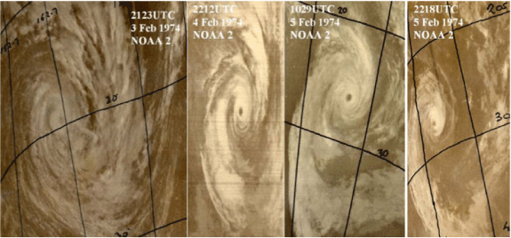
From the database repair project TC Pam was notable as being the first category 5 cyclone in the Australian region, having a CP of 925hPa. This was based upon a post-1979 reanalysis that determined Dvorak CI = 6.5 at 23 UTC 4 February 1974 as it entered the Australian region at a latitude of 24°S after impacting Vanuatu. This was significantly stronger than the operational estimate that determined the CP at 970 hPa, which had been retained in the BT. The series of NOAA2 images (Fig. A3.1) showed a well-defined eye on 4–5 February before weakening. While the eye was well defined on 4–5 February, the narrow width of the southern eyewall would not meet the criteria for 6.5 in current understanding. Also, there hasn’t been a Dvorak Technique (DT) of 6.5 (category 5) south of 22°S in the Australian region. While acknowledging the uncertainties with the limited satellite coverage, the peak is reassessed at CI = 6.0 and 105 kn.
|
A3.2 Tracy, 1974
Tracy, the most famous of Australian TCs, was well scrutinised following the event (Bureau of Meteorology 1977). The landfall CP was reliably recorded as 950 hPa at Darwin airport, and the anemometer recorded 217 km/h before being damaged. The report also documented the CI from twice daily NOAA-4 images having a peak of 5.5 based on the image at 1448 UTC 23 December, some 28 h prior to landfall, and concluded the landfall intensity was 140–150 km/h (75–80 kn) with gusts as high as 240 km/h (130 kn). A more recent investigation into the intensity (Courtney and Shepherd 2010) estimated the landfall intensity was 95 kn, noting that the peak intensity could well have been higher in the period during the previous 30 h given the variation in eye diameter evident on radar.
Being a small system, the original visible DT are likely underestimates. However, the imagery was not sufficiently clear to alter the original report’s 5.5 CI estimate, and hence maximum winds (Vm) are estimated at 95 kn for this period. This corresponds to wind gusts of 135 kn (250 km/h), which is consistent with the estimate of 240 km/h in the report. It is also consistent with a storm surge investigation (Harper 2010) that noted:
‘it is speculated that the suburban areas between the airport and the coast, which were very extensively damaged, may have actually experienced higher wind gust speeds than measured by the Dines instrument – perhaps as high as 70 ms–1’ or 135 kn (250 km/h).
Earlier CI estimates were adjusted in the 2010 reanalysis. For example, the 21/0032 UTC NOAA 4 visible image (see Fig. A3.2) is described as being FT=2.0, but the tight curvature of the deep convection would suggest it may be at least FT=3.0 at the time (refer p. 24 of the report). The NOAA4 image at 21/2332 UTC was estimated at FT=3.5 but with indications of an eye and strong banding, this is more likely to be at least 4.0 and more likely 4.5. Hence, winds during this period of intensification are increased and the time for initial TC intensity is brought forward some 12 h to coincide with when it was estimated at FT=3.0.
|
Extra fields for the 18 UTC 24 December landfalling fix were added from details in the report. This includes RMW (4 nm), POCI (1004 hPa), R34 (25 nm), R48 (13 nm), R64 (7 nm) eye radius (3 nm).
Extra fixes are added at standard times (interpolated), and for pre and post-BT track based on TC track in report (p. 3).
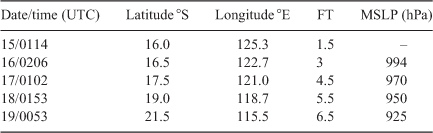
A3.3 Trixie, 1975
TC Trixie formed as it moved off the Kimberley, tracking close to the coast and crossing the Pilbara coast as an intense system. Like Tracy, less than 2 months previously, Trixie was a powerful TC that affected the land. The BT peak was 925 hPa, the lowest pressure in the Australian region until then. The official report intensity appears to be influenced by observations. Mardie recorded winds of 204 km/h (110 kn) with several gusts of at least 259 km/h (140 kn).
Table A3.1 shows the peak Dvorak CI at 6.5 from the ESSA 8 visible image at 0053 UTC 19 February. However, the report notes that an eye was not visible. Technically, to achieve a T6.5 without an eye, a Central Dense Overcast of >2.25 degrees would require an additional 1.0 from a banding feature. Although the original image is not available to review, this seems unlikely and would only seem possible if the eyewall was so small it was not detected at that satellite resolution. The report detailed Port Hedland radar fixes, including eye diameters in the range of 37 km to more than 50 km at times (so not notably small). This highlights the inherent difficulties with intensity estimation prior to the geostationary stationary era.
|
A3.4 Dominic, 1982
Dominic rapidly intensified in the Gulf of Carpentaria before crossing Cape York. The original BT peak intensity at landfall was 950 hPa, equivalent to 90 kn using Dvorak WPR. Reanalysis indicated that DT at 09 UTC (Fig. A.3.3) just prior to landfall was 6.5–7.0, although earlier images showed fluctuating DTs between 5.5 and 6.5. The peak the landfall intensity was estimated at 6.5 (115 kn). This amounts to a change of 2.0 over 24 h. This also makes it the first recorded category 5 TC in the Gulf of Carpentaria.
|
A survey of damage indicates severe vegetation damage near landfall point ‘one mile north of Cape Keerweer was an area devoid of all vegetation (no grass or trees) – the area appeared like a ploughed field for one mile inland’ which would indicate an intense system. Winds were estimated to have reached 185 km/h (100 kn) at Edward River Mission (Pormpuraaw) south of the crossing point.
A3.5 Elinor, 1983
TC Elinor was a long-lived Coral Sea event with a double intensity peak, crossing near Mackay where the intensity was revised to be a TC rather than a tropical low.
A reanalysis increased the peak intensity from 100 to 110 kn based on CI = 6.5 from 18 UTC 24 February to 06 UTC 25 February (Fig. A3.4). Lihou Reef reported 100 kn when the system was weaker on 28 February but then the Automatic Weather Station (AWS) began to report erratically, with the speed repeatedly getting stuck on 100 kn and the direction widely varying. There were similar occurrences with winds exceeding 90 kn reported at other AWS during this era, and hence, the intensity was estimated at 90 kn from 18 UTC 27 February to 06 UTC 28 February, but still above CI estimates, and then gradually decreased to be consistent with CI by 18 UTC 28 February.
Winds also increased as it approached the coast from 30 to 55 kn on 3 March, easing to 35 kn at landfall. This was based on damage on the coast and adjacent islands and estimates of winds from Pine Islet (70–75 kn) and Marble Island (50–60 kn). Winds were enhanced on the southern side higher than Dvorak CI, owing to synoptic forcing. Extra fixes were added for landfall.

|
A3.6 Kathy, 1984
Like TC Tracy some 10 years prior, Kathy was an intense small cyclone that made landfall in the NT. The official report (BoM, 1984) estimated the peak intensity at 920 hPa and 112 kn based on a Dvorak CI of 6.5. A later review revised the CI to 7.5 corresponding to 130–135 kn. The report describes damage at Borroloola and the adjacent Sir Edward Pellew Group of islands consistent with a category 4 or 5 impact.
A reanalysis of HURSAT imagery shown in Fig. A3.5 supports a peak CI of 7.0 sustained for ~18 h but not 7.5. This would suggest a Vm of 120–125 kn. Imagery in the final hours near landfall did deteriorate from GMS but the CI is still estimated at 6.5 (note GMS2 failed, so GMS1 was used).

|
Centre Is recorded 940 hPa in the eye at 20 UTC 22 March and winds 100 kn prior to failure of the mast. A nearby ship also measured 938 hPa in the eye. Using CKZ WPR for a gale radius of 60 nm (estimate from IR imagery) and Pe of 1010 hPa (from MSLP analyses), latitude 15°S and translation speed of 5 kn, the corresponding wind speed for a CP of 940 hPa was 107 kn. Note that for a pressure of 920 hPa, the wind estimate is 125 kn. The measured winds prior to failure of 100 kn was a lower bound of the likely intensity and does not provide much guidance to determine the peak winds.
The data suggests the peak winds were in the range of 105–125 kn. The revised intensity around the time of passing over Centre Is 110 kn because of the observed pressures. The peak intensity is estimated at 120 kn from 03–14 UTC 22 March matched to the CI of 7.0 and the suggested minimum pressure was more likely to be in the range of 930–935 hPa, closer to the measured 938–940 hPa mark than 920 hPa in the original database. It is possible that there were eyewall changes occurring, but without microwave imagery this remains speculation.
The imagery indicates some weakening at landfall itself, and because of some impact of the islands, the mainland landfall intensity is estimated at 105 kn.
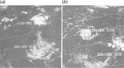
A3.7 Jacob, 1985
TC Jacob developed in the Timor Sea then moved to the southwest over open waters in the western region. The reanalysis reduced the original database peak from 96 to 75 kn based on the reanalysed CI of 4.5. The reasons for the decrease are three-fold:
At the time, winds were consistently overestimated as 1-min winds and were used in the conversion from CI (western region practice for 1984–85 to 1986–87).
HURSAT imagery (Fig. A3.6; AVHRR and GMS) shows that the peak Dvorak estimates were likely to be 4.5 using an embedded centre and a weak eye analysis based on a partial Dvorak reanalysis. The literal application of the embedded centre pattern to derive a CI of 5.0 appeared to be quite evident in the western region during the 1980s.
During the weakening phase, it is possible that a 1.0 lag was used to hold the CI higher than FT. For example, imagery at 06 UTC 23 February indicated that the DT and the FT were on the order of 3.0, and by holding CI higher at 3.5, this would suggest a Vm of 50 kn, considerably less than the original database estimate of 88 kn, which is equivalent to a CI of 5.0 (using the CI 1-min winds conversion).

|
A3.8 Barisaona, 1988
TC Barisaona was upgraded to be a TC inside the Australian region on the basis of HURSAT imagery from 7 November until tracking west of 90°E on 11 November when it reanalysed at 60 kn (CI = 4.0). Barisaona was originally named after leaving the Australian region. See Fig. 3.
A3.9 Orson, 1989
Until Monica in 2006, TC Orson was considered the most intense TC in the Australian region, the original database having Vm = 134 kn and a CP reliably measured at 905 hPa at North Rankin platform and CI = 7.0. The official report, Bureau of Meteorology (1992), did not include the Vm and only provided a description of Dvorak CI values. The original 134 kn Vm are 1-min estimates, as was the practice in the western region for the late 1980s, and the correction would lower that to 125 kn. Applying the CKZ WPR using 905 hPa matched a Vm of 130 kn. A reanalysis using HURSAT indicated CI = 7.0 possible between 18 UTC 21 and 12 UTC 22 April. The satellite signature weakened by the time Orson passed over North Rankin at 16 UTC, where the CI was estimated at 6.5 and then 6.0 at landfall at 21 UTC 22 April.
SSMI 85 GHz microwave images (Fig. A3.7) showed a very small eye surrounded by an outer wall, suggesting that a perhaps ERC was commencing. However, the North Rankin wind profile did not show a double wind maximum, and the RMW was just 20–30 km. This was supported by Dampier radar, which showed an eye diameter of 40 km. So, it is likely the small eyewall was retained during this period. The last available image at 2227 UTC 21 April was 23 h before landfall and 17 h before the North Rankin pressure minimum, but subsequent EIR images show a weakening of the eye by landfall.

|
The reanalysed peak intensity was estimated at 130 kn, as derived from the North Rankin pressure observation, slightly higher than Dvorak CI estimates would suggest, and this offset was reflected to landfall at 00 UTC 22 April.
A3.10 Felicity, 1989
Felicity developed in the northern region and moved east-southeast over the Gulf of Carpentaria to cross Cape York and then emerged into the Coral Sea near Cairns where it redeveloped. Vm were reanalysed to be higher in the Gulf of Carpentaria and in the Coral Sea (Fig. A3.8).
Gulf of Carpentaria:
The original BT winds of 50 kn at landfall appeared to be a significant underestimate and at odds with the BT pressure of 975 hPa, which did not correspond to any WPR (Pe = 1010 hPa). The Dvorak reanalysis peaked at DT = 5.5 just after landfall (eye emerged near landfall), although the reanalysed landfall CI was more conservatively estimated at a strong 4.5 at 09 UTC (using a 3 h average DT) to suggest a Vm of 75 kn. The fact that damage reports indicated trees were stripped of leaves and 80% blown down in offshore winds definitely pointed to a severe impact. An eyewitness described winds as being more intense than during Althea in 1971 when Townsville recorded wind gusts of 106 kn. Although anecdotal evidence can be unreliable, it could even suggest Vm were even higher at 80–95 kn. It is not known why the original database winds were so much lower. The post landfall intensity was also higher as the DT peaked in the hours after landfall.
Coral Sea:
The original database winds peaked at 33 kn, presumably based on CI estimates at 2.5, but reanalysed winds reached 60 kn based on observations at Holmes Reef (60 kn at 22 UTC 16 December), Flinders Reef (55 kn at 19–22 UTC 16 December) and Willis Is (60 kn at 11 UTC 17 December gusting 76 kn). These winds occurred in the southwest quadrant and are partially attributed to the strong high to the south. These winds were higher than the Dvorak CI suggested. The CI peaked at 3.0 from 12 UTC 16 to 00 UTC 17 December. The difference illustrates the uncertainty in satellite-only estimates. It is not known why the surface observations were not fully considered during the reanalysis but possibly consideration was for winds completely around the centre rather than the maximum in a single quadrant. From 06 UTC 17 December, gales were estimated to be restricted to the western quadrants only, so technically, the system was below TC intensity even though Vm were 50–60 kn until 00 UTC 18 Dec.

|
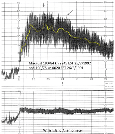
A3.11 Kelvin, 1991
Kelvin was a long-lived Coral Sea system with an erratic track and winds higher than the standard Dvorak estimates because of strong synoptic flow both north of the centre in the monsoonal flow and to the south in the southeasterly flow. Wind shear affected the system throughout its lifetime, and Dvorak estimates only reached 2.5–3.0; however, Willis Is recorded a peak of 65 kn at 12 UTC 25 February and gusts up to 84 kn (Fig. A3.9). The reanalysed peak winds increased from 55 to 60 kn around this time. This increase was short of the observed peak, as there was insufficient evidence to determine if this was representative of the peak. The original BT winds were 55 kn for an extended period from 10 UTC 25 February to 12 UTC 27 February and 06 UTC 3 March to 12 UTC 4 March, and while it was likely that winds eased at times during these periods, it was difficult to determine without more detailed information.
|
A3.12 Neville, 1992
Neville was a small and intense Timor Sea system that developed rapidly. Detailed satellite reanalysis indicated TC intensity estimated at 18 UTC 5 April, supported by SSMI microwave data. This estimate was much earlier than the original BT, which only started a track on 7 April. The peak of 6.5 at 00 UTC 9 April was based on AVHRR EIR and supported by ADT; however, lower resolution HURSAT GMS imagery did not sufficiently resolve the eye temperature (Fig. A3.10).

|
A3.13 Rewa, December 1993–January 1994
Rewa was a long-lived Coral Sea TC with multiple peaks. Original BT pressures and winds had different relationships. For the first peak, the original BT pressure was 920 hPa against winds of 90–95 kn (2–3 January) even though the internal BoM report mentioned 110 kn; but for the second intensity peak, 920 hPa was matched with 110 kn (16 January).
The HURSAT reanalysis showed that DT numbers fluctuated between 6.0 and 7.0 during the initial peak on 2 January, coincident with a well-defined compact microwave eye, and as a result, the initial peak was adjusted from 80–95 to 110 kn from 06 UTC 2 January to 00 UTC 3 January. The second peak was earlier but still at 110 in intensity, and then weakened faster (Fig. A3.11).

|
A3.14 Rosita, 2000
Rosita crossed the Kimberley coast near Broome as a category 5 system. The original BT peak intensity was 100 kn, but this was inconsistent with the BT of CI = 6.5 and being documented as a category 5 system. The original FT = 6.5 was noted as being constrained, given intensity rates; however, reanalysis supported a Dvorak FT at 7.0 without breaking constraints when applying the 2020 approach. This increased the landfall intensity to 120 kn (Fig. A3.12).

|
Rosita moved over flat terrain and weakened at a slower rate than the standard inland decay rate (Kaplan and DeMaria 1995) as evidenced by satellite imagery.