
Developing impact-based thresholds for coastal inundation from tide gauge observations
Ben S. Hague A B C , Bradley F. Murphy A , David A. Jones A and Andy J. Taylor AA Bureau of Meteorology, GPO Box 1289, Melbourne, Vic. 3001, Australia.
B School of Earth, Atmosphere and Environment, Monash University, Clayton, Vic., Australia.
C Corresponding author. Email: ben.hague@bom.gov.au
Journal of Southern Hemisphere Earth Systems Science 69(1) 252-272 https://doi.org/10.1071/ES19024
Submitted: 3 December 2018 Accepted: 14 October 2019 Published: 11 June 2020
Journal Compilation © BoM 2019 Open Access CC BY-NC-ND
Abstract
This study presents the first assessment of the observed frequency of the impacts of high sea levels at locations along Australia’s northern coastline. We used a new methodology to systematically define impact-based thresholds for coastal tide gauges, utilising reports of coastal inundation from diverse sources. This method permitted a holistic consideration of impact-producing relative sea-level extremes without attributing physical causes. Impact-based thresholds may also provide a basis for the development of meaningful coastal flood warnings, forecasts and monitoring in the future. These services will become increasingly important as sea-level rise continues.
The frequency of high sea-level events leading to coastal flooding increased at all 21 locations where impact-based thresholds were defined. Although we did not undertake a formal attribution, this increase was consistent with the well-documented rise in global sea levels. Notably, tide gauges from the south coast of Queensland showed that frequent coastal inundation was already occurring. At Brisbane and the Sunshine Coast, impact-based thresholds were being exceeded on average 21.6 and 24.3 h per year respectively. In the case of Brisbane, the number of hours of inundation annually has increased fourfold since 1977.
1 Introduction and motivation
As the earth warms under the enhanced greenhouse effect, global sea levels have risen significantly due to the thermal expansion of sea water and the melting of land ice (Church et al. 2013; IPCC 2014). In the Australian region, both tide gauges and regional satellite data show a significant rise which is broadly in line with the global trend (Bureau of Meteorology 2019; McInnes et al. 2016; McInnes et al. 2015; Couriel et al. 2014; White et al. 2014; Watson 2011; You et al. 2009; Church et al. 2006).
Substantial future sea-level rise can be expected as a result of past and future greenhouse gas emissions (IPCC 2014). Many studies have projected increases in mean and extreme sea levels for Australia in the future (e.g. Wahl et al. 2017; McInnes et al. 2016; CSIRO and Bureau of Meteorology 2015; McInnes et al. 2003a, 2009, 2013; Morris et al. 2013), and these are the basis for a range of planning and adaptation responses being put in place. Devlin et al. (2017) also note that changes in tidal range may amplify or mitigate against changes in mean sea levels. Although future impacts are dependent on assumptions about social and economic changes in the coastal zone and future adaptation and emission pathways, it is evident that these impacts will be significant (Reisinger et al. 2014).
In contrast to the large body of research focusing on future changes, few studies have investigated changes in the frequency of extreme sea-level events due to the already-observed changes in mean sea level. Eliot (2012) and Pattiaratchi and Eliot (2008) found a significant increase in the frequency of exceedances of vertical thresholds at gauges in south-west Western Australia, and CES (2018) found similar results for tide gauges in Victoria. However, such increases can only be translated into direct physical impacts if the relationship between the thresholds used and the water levels that cause inundation on land is known.
Church et al. (2006) attempted a national assessment of changes in the frequency of extreme sea-level events over the 1920–2000 period but deemed tide gauge records to be of insufficient length at all but two (southern Australian) locations. With tide data now extending over more than 30 years at many sites, we see value in re-examining the question of whether extreme sea level frequencies are changing, and if this is associated with increasing impacts. WMO (2011) states that 30 years of climatological data is enough to capture climatological variability of physical parameter, and this period is greater than the 18.6-year nodal cycle which is the most significant source of low-frequency variability of astronomical tides (Haigh et al. 2011).
We have chosen to restrict the scope of this initial study to Northern Australia, though the approach is generic. It is notable that Queensland was assessed by the DCCEE (2011) as having the largest asset value threatened by climate change–related sea-level rise. Future work is planned to apply the method described herein to other locations across Australia, and potentially to the broader Pacific region.
The physical drivers of coastal sea levels cross a complex range of spatial and temporal scales (McInnes et al. 2016). Academic studies have understandably focused on understanding these and attributing effects to these drivers. In the Australia-Pacific region, storm surges (e.g. Callaghan and Helman 2008), wave run-up and set-up (e.g. Hoeke et al. 2013), infra-gravity waves (e.g. Hoeke et al. 2013; Damlamian et al. 2015), coastally trapped waves (e.g. Maddox 2018a, 2018b), astronomical tides (e.g. Hanslow et al. 2018; Ford et al. 2018), tsunami (e.g. Beccari 2009; Fritz et al. 2011), meteotsunami (e.g. Pattiaratchi and Wijeratne 2015) and climatic variability (e.g. Widlansky et al. 2013) all have been associated with impact-producing extreme sea-level events. The analysis we apply here more closely follows conventional climate analysis where changes in statistics are explored without attempting to diagnose the drivers.
In addition to defining inundation thresholds and allowing an analysis of the changing frequency at which these thresholds are exceeded, the information we provide here is valuable for informing impact-based forecasting, warning and monitoring services. Forecasts and warnings that provide reference to potential impacts are essential for population safety and asset protection; however, these cannot be developed without the knowledge of historical impacts to inform forecasting and warning criteria (WMO 2015). Impact-based thresholds for climate analysis and hydrometeorological forecasting are commonly used in Australia, for example in agriculture (e.g. Asseng et al. 2011), extreme heat (e.g. Nairn and Fawcett 2013), riverine flooding forecasting and warnings (Bureau of Meteorology 2013) and tsunami warnings (Allen and Greenslade 2008). The Bureau of Meteorology (2013) defines the lowest flood threshold (minor) as corresponding with impacts such as inundation of areas near watercourses, including pedestrian and bicycle paths, as well as the closure of roads and low-level bridges. However, there are very few tidal waterways with these flood thresholds defined. Given these impacts are like those that occur during coastal inundation events (e.g. Witness King Tides 2019; Green Cross Australia 2012; DERM 2011), the definition of impact-based thresholds in the coastal zone complements the existing riverine and estuarine thresholds. This is also consistent with international coastal flood classifications (e.g. Ghanbari et al. 2019).
Outside of Australia, a few studies have used impact-based thresholds to study coastal inundation. Ford et al. (2018) defined impact-based thresholds by collating impact reports and finding corresponding tide gauge levels at one gauge in the Marshall Islands, and Sweet et al. (2018) defined thresholds for inundation on a continental scale. However, Sweet et al. (2018) relied on an assumption of intercomparability of sites rather than sourcing impact reports at every location where thresholds are defined. Furthermore, the sites used as the basis for this comparison typically had flood thresholds defined using a harmonic parameter, mean higher high water (NOAA 2018), which is defined without reference to water levels that may cause inundation on land. Haigh et al. (2017) collated the impacts of historical coastal flooding events in the UK and assessed events on an impact-based scale but did not define tide level thresholds associated with these impacts. Thus, our study is the first to apply a consistent methodology to define impact-based thresholds at multiple tide gauges using actual impact reports along large stretches of coastline.
Another benefit of impact-based thresholds lies in their ability to easily account for compound events where impacts can occur from the combining effects of multiple, often minor, factors (Leonard et al. 2014). Sometimes these factors are all directly related to sea level (e.g. as described by McInnes et al. 2016) but sometimes can be due to estuarine, fluvial and pluvial flooding interacting with higher ocean levels at coastal margins (e.g. Wu et al. 2018; Moftakhari et al. 2017, 2018; Callaghan and Power 2014). Impact-based thresholds allow localisation and personalisation of climate risks which can raise local awareness (Velautham et al. 2019). They also assist policymakers to develop relevant policies for their jurisdictions (CSIRO and Bureau of Meteorology 2015) with reference to past impacts within residents’ memories. This work has the potential to provide guidance for possible coastal impacts when coupled with Australian storm surge (e.g. Greenslade et al. 2018; Allen et al. 2018) or total water-level models (e.g. Taylor and Brassington 2017). It is worth noting that extremely low sea levels can also produce impacts (e.g. Bureau of Meteorology 2011; Widlansky et al. 2013); however, this study focuses on defining impact-based thresholds for extreme high sea levels only, due to the well-documented likely increases of these events as a result of climate change.
Most studies in the Australia-Pacific region have hitherto utilised annual recurrence intervals (ARIs) or annual exceedance probabilities (AEPs) to define extreme sea-level events (Stephens et al. 2016, 2018; Pattiaratchi et al. 2018; Stephens 2015; Haigh et al. 2012, 2014a, 2014b; McInnes et al. 2003b, 2013; Church et al. 2006). By construction, ARIs and AEPs focus primarily on events that occur infrequently (e.g. once every 10 years) which may or may not be associated with impacts. However, studies and reports from Australia (Attard et al. 2019; Witness King Tides 2019; Hanslow et al. 2018; Maddox 2018a; Zheng 2017; Jacobs 2012, 2014, 2015, 2016; Green Cross Australia 2012; DERM 2011; DECCW 2009; Watson and Frazer 2009) and overseas (Hino et al. 2019; Roman-Rivera and Ellis 2018; Jacobs et al. 2018; Rojas et al. 2018; Haigh et al. 2017; Sweet et al. 2016; Ray and Foster 2016; Selvaraj 2016; Ezer and Atkinson 2014; Sweet et al. 2014) have documented infrastructure, economic, environmental and social impacts associated with high sea levels occurring at near-annual, annual or subannual frequencies, mostly due to high astronomical tides.
Some studies have used tidal parameters derived from harmonic analysis to define extreme sea levels (e.g. Hanslow et al. 2018; CES 2018; Stephens 2015; Stephens et al. 2014; Morris et al. 2013; Bureau of Meteorology 2011). As these metrics are typically exceeded on an annual or subannual basis, they are better placed to provide useful insights on impacts and projections for tidal-driven coastal inundation. However, an important additional consideration is the vulnerability of land and infrastructure to these extreme sea levels. These metrics cannot consider the effect that local variations in planning policy may have on differences in vulnerability. For example, through the spatial variability of the heights of vertically offset assets (houses, roads, ports, etc.) above typical high-tide levels (Brown et al. 2018; Kirkpatrick 2012).
This study addresses several key gaps in existing knowledge of Australian extreme sea levels. It pulls together contemporary reports of coastal inundation with quality tidal observations to develop thresholds at which inundation impacts are felt. These thresholds are then used to develop time series of inundation, including an analysis of emergent trends. Finally, the framework we develop provides the basis for the future forecasting, warning and monitoring of coastal inundation events in real-time, like what is already undertaken for variables such as rainfall and temperature.
2 Data and methodology
2.1 Data sources and processing
The Bureau of Meteorology maintains a national repository of hourly resolved relative sea-level observations from tide gauges. These gauges are typically located on coastal infrastructure like jetties and are operated by the Bureau, port authorities and other agencies. Much of this data has been added to other repositories such as the Global Extreme Sea Level Analysis (GESLA)-2 project (Woodworth et al. 2017, http://gesla.org/, accessed 20 April 2020), the University of Hawaii Sea Level Center (UHSLC) database (Caldwell et al. 2015, https://uhslc.soest.hawaii.edu/data/, accessed 20 April 2020) and the Bureau’s Australian Baseline Sea Level Monitoring Project (ABSLMP) database (http://www.bom.gov.au/oceanography/projects/abslmp/data/index.shtml, accessed 20 April 2020). Hourly values are produced on an annual basis, with data up to the end of 2017 available for use in this study.
This data set contains only relative sea level, which is of primary concern for coastal inundation. Connections to survey reference elevations such as Australian Height Datum (AHD) or geodetic ellipsoidal heights are important for many applications but are not treated directly here. Overt shifts in tide gauge datums present a pragmatic challenge to homogenising long records and our approach is detailed below. Making precise survey connections between impact-based threshold values derived from tide gauge observations and common datums would represent a valuable extension but is beyond the current scope.
The hourly resolution of the data limits the study’s ability to consider contributions to extreme sea levels that occur on timescales of less than 1 h. The hourly values are typically produced by resampling and filtering higher frequency data. This means they are more representative of an average sea level over an hour than an instantaneous value.
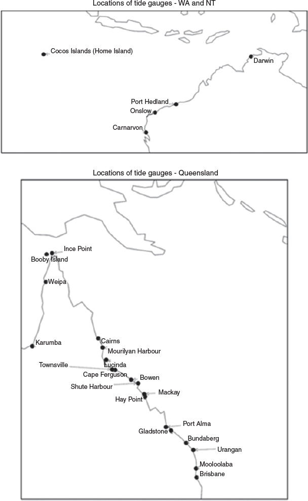
Although impact-based thresholds can be defined for a gauge record of any length, provided impacts are reported during the period of data availability, WMO (2011) recommends 30 years of homogeneous data with 80% data completeness for climatological information. Given the homogeneity of Australia’s tide gauge records has not been assessed in the same way as other climatic variables, for example temperature (Trewin 2013, 2018), the completeness criterion is tightened to 90%. This helps account for the fact that long periods of missing data potentially indicate a replacement of equipment or site move, both of which may result in an inhomogeneity (Trewin 2013). As Table 1 shows, only tide gauge records with at least 27 data-years (i.e. 30 years with 90% completeness), and 90% completeness over the entire data period are used. In some cases, this has required records to be shortened (but not to less than 27 data-years) to meet these criteria. Figure 1 shows the geographical locations of these gauges.

|
|
White et al. (2014) assessed the suitability of Australian tide gauge records for monthly trend and variability analysis. They found anomalous trends at Wyndham and King Bay, and undetected datum shifts at the Gold Coast, that suggests further investigation as part of a homogenisation procedure is required. For the purpose of this analysis, these locations are excluded.
2.2 The definition of impact-based thresholds, exceedances and events
Impact-based thresholds are defined as the lowest hourly sea level for which coastal inundation impacts are reported at a location. This is achieved by collating multiple reports of coastal inundation impacts and matching the times of these impacts to sea levels recorded at a proximate tide gauge, typically within 20–50 km. The lowest of these sea levels is then designated as the impact-based threshold for that tide gauge location.
An implication of this definition is that it is possible that inundation does not always occur when the impact-based threshold is exceeded. This could be for many reasons, such as higher frequency sea-level variability such as waves not detected by a tide gauge, or that there are small differences between the sea level at the tide gauge and where impacts are observed. In determining impact-based thresholds, we have ignored reports of impacts on open coasts where waves are more prevalent.
Frequency of inundation is measured using two different metrics, exceedances and events. An ‘exceedance’ is a single instance of the hourly sea level being higher than the defined impact-based threshold. An ‘event’ is a period of at least one exceedance. An event starts at the time of the first exceedance and ends at the time of the last exceedance, assuming there are no subsequent exceedances within the following 48 h. This period of 48 h ensures that the hourly sampling of the data captures the highest high tides of each diurnal cycle, which is on average 24 h and 50 min, and that prolonged events lasting multiple days are captured. Related concepts can also be defined, such as ‘annual event frequency’, the annual number of extreme sea-level events, and ‘annual average exceedances per event’, which is the quotient of the annual total number of exceedances and the event frequency. These concepts help determine the relative contributions of changes in the frequency and duration of events.
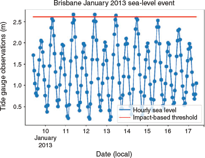
In most cases the sea-level values associated with inundation that are used to define the impact-based thresholds are the highest daily hourly sea levels; however, sometimes event maximum hourly values are used if there is not enough information to determine the exact timing of the inundation. Daily or event maximum values are used to bias the method against defining an impact-based threshold too low; this means the thresholds defined herein are equivalently a little high. Figure 2 demonstrates the difference between event and daily maximum values and how these can be used to develop impact-based thresholds. In this example, the event maximum is the highest observation above the red impact-based threshold line. If the daily maximum on the 15th was to have also been above the red line, this would trigger a new event, whereas a higher value on the 14th would be part of the event beginning on the 11th. If the 11th, 12th and 13th were the only days where impacts were reported in the observational record and impact reports were clearly dated and timed, then the maximum hourly observation on the 13th would be the impact-based threshold as this is the lowest of the three daily maximum values. If the reports were not clearly dated (e.g. a news report from the 15th mentioned inundation in the previous week), the event maximum would be used for the impact-based threshold.
|
Typically, two processes were used to match impacts with sea-level observations. The first (‘impact first’) involves identifying an impact and then searching for a candidate extreme sea-level event. The second (‘event first’) involves generating a list of candidate events from the hourly maximum sea-level observations and then searching for impacts associated with those times. These two processes operate ad infinitum, producing increasingly accurate estimates of the impact-based threshold as more evidence is uncovered, or future impact-producing sea-level events occur. Candidate events in the ‘event first’ method were usually generated as any observed exceedance of the highest astronomical tide (HAT), which is the conventional definition of extreme sea level used by the Bureau of Meteorology (2011). By construction, ‘impact first’ will predominate if the impact-based threshold is below HAT, whereas ‘event first’ will dominate if the impact-based threshold is above HAT. In either case, the more coastal inundation events that are reported, the less influence HAT has on the final impact-based threshold. If no impacts were documented, no impact-based threshold has been defined. If there was evidence to suggest impacts occurred on an annual or multiyear basis but no specifics on exactly when it occurred, HAT was designated the impact-based threshold.
2.3 Finding reports of coastal inundation
Given the scarcity of impact-based threshold and impact reports for coastal inundation in Australia within the scientific literature; this study relies heavily on pictorial, dated and eyewitness evidence of extreme sea-level impacts. The three most frequently cited sources are Queensland Government-sponsored pictorial surveys conducted in 2012 (Green Cross Australia 2012) and 2011 (DERM 2011), and the Flickr account of Witness King Tides (2019). Other sources of information include recent online news and social media (e.g. Twitter, Facebook and Instagram) searches after and during coastal inundation events. Correspondence with the Bureau of Meteorology staff in Queensland, Northern Territory, Western Australia and Cocos Islands offices also provided evidence of extreme sea-level impacts that were not previously documented in the scientific literature or media. These expert anecdotal sources were especially useful for more isolated areas. Confirmation bias is potentially an issue, as reports of nonevents or near misses are rare, and it is impossible to determine whether this is because they did not occur or because they were not reported, or both. Sparsely populated areas are likely more susceptible to this bias than large towns and cities.
2.4 Missing data considerations
Further to the commentary on data completeness in Section 2.1, additional considerations are required to mitigate against the effects that missing data may have. WMO (2017) provides some guidance as to the handling of missing data for count parameters such as the number of exceedances of a threshold per year. The advice is that counts should be calculated using ratios of available data in the averaging period rather than the length of averaging period. Based on this advice an adjusted exceedance count is used. In practice, this means that if a year has 10% missing data and has 9 occasions where the designated threshold has been exceeded throughout the remainder of the year (i.e. the 90% where data is not missing), then the adjusted exceedance count is 10. The adjusted exceedance count is used subsequently in this analysis and referred to simply as ‘exceedance’.
Second, in addition to the 80% overall criterion, upgraded to 90% as discussed in Section 2.1, WMO (2017) states that for a count parameter to be calculated in a given time period, at least 70% of the data must be available. Therefore, the adjustment procedure is only applied to years with at least 70% completeness. If years have less than 70% completeness, they are not used for the purposes of statistical analysis of trends in exceedances.
Event analysis has added complexity due to the decomposition of events into their frequency and the number of exceedances per event. Therefore, the implicit independence assumption used by WMO (2017) in defining the adjusted exceedance count may not hold. Hence, no adjustments to event counts were made and a minimum data completeness of 95% was imposed for years to be included in the analysis of trends.
3 Results and discussion
3.1 Impact-based thresholds for northern Australia
Table 2 lists the impact-based thresholds defined at the 24 locations in northern Australia considered in this study, using the methodology described in Sections 2.2 and 2.3. Two examples of how the impact-based thresholds were derived are given below for two major population centres in northern Australia with long tide gauge records: Brisbane and Townsville. For the sake of brevity, information on the determination of impact-based thresholds at the other 22 locations is presented in Appendix 1. Table 2 also presents the HAT value (Australian Hydrographic Service 2017), and trends in exceedances, events, and average number of exceedances per event, as defined in Section 2.2.

|
3.2 Determining the Brisbane impact-based threshold
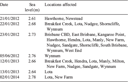
Coastal inundation occurs regularly in Brisbane, typically associated with high astronomical tides. Figure 3 provides images of inundation on 2 January 2018, 12 July 2018 and 21 February 2019. Provisional (UHSLC Fast Delivery) hourly maximum values of 2.85, 2.91 and 2.74 m are associated with these days of inundation respectively (Caldwell et al. 2015; http://uhslc.soest.hawaii.edu/data/?fd). Witness King Tides (2019) documents four inundation events between 2012 and 2014, with inundation occurring on 7 separate days (Table 3). The lowest of these daily maxima is 2.61 m. Note that as the impacts are clearly dated the daily maximum sea levels can be used, rather than event maximum, even though many of the days with impacts are from the same event. Figure 2 shows that the equal-highest observation of the period was on 11 January 2013; however, this does not appear in Table 3, as no impact reports could be found for this day. This does not necessarily mean that impacts did not occur, merely that if they did, they were not reported. Even if they did not occur, this is not incongruous with the impact-based threshold definition as that merely states that it is the lowest sea level at which inundation is reported.

|
|
DERM (2011) reported inundation at numerous locations in the wider Brisbane area (Cleveland Point, Lota, Luggage Point, Albion, Nudgee, Sandgate, Shorncliffe, Scarborough and Deception Bay) on the morning of 21 January 2011 (local time). The highest hourly sea-level recorded at around this time at the Brisbane tide gauge was 2.74 m at 0100 UTC (i.e. 11 a.m. local time) on the 21st. Green Cross Australia (2012) reported inundation at numerous locations on the morning of 22 January 2012 (local time) (Lota and Cleveland) and 23 January 2012 (Cleveland, Brisbane CBD, Hawthorne, East Brisbane, Sandgate and New Farm). The daily highest hourly sea levels associated with these coastal inundations were 2.68 and 2.73 m respectively. Williams (2015) reported inundation at Sandgate on 20 January 2015, when sea levels reached 2.79 m. Flooding also occurred 2 days later in Newstead and Albion (Orr 2015) at a 2.82 m sea level. Based on these observations, the impact-based threshold is defined as 2.61 m, the lowest daily value, which occurred on 21 January 2012 with impacts reported at Hawthorne and Newstead (Table 3).
3.3 Determining the Townsville impact-based threshold
Like Brisbane, coastal inundation is now a regular occurrence in Townsville, with many reports of inundation around the city over the last decade. There are two tide gauges within the vicinity of Townsville, one at Townsville and another at Cape Ferguson. Due to their proximity, the same inundation events are used to define impact-based thresholds at both gauges.
A storm surge and king tide associated with ex-Tropical Cyclone Dylan (Bureau of Meteorology 2018a) on 30 January 2014 produced widespread flooding of roads and properties in Townsville and at nearby Magnetic Island (Fernbach et al. 2014; Denison 2014; Dunn et al. 2014). Sea levels on that day reached 4.34 m at Townsville and 3.99 m at Cape Ferguson. Inundation of coastal infrastructure also on Magnetic Island occurred on 31 January 2010 (Witness King Tides 2019). GHD (2012), in a report commissioned by Townsville City Council, note that damage due to storm surges and king tides occurred in 1971 due to TC Althea (event maximum of 4.42 m at Townsville), in 2009 during Cyclone Charlotte (4.38 m at Townsville and 4.04 m at Cape Ferguson) and in 2011 during Severe Tropical Cyclone Yasi (4.46 m at Townsville and 4.00 m at Cape Ferguson). Systems Engineering Australia (2009) noted that Cyclone Charlotte damaged coastal protections and infrastructure at several locations in Townsville, including very close to the tide gauge. Yasi also caused inundation in Townsville (Bureau of Meteorology 2018b) where an extreme sea-level event occurred due to a large surge despite the astronomical tide at the time being 70 cm lower than HAT, with observations of 4.34 m at Townsville and 4.0 m at Cape Ferguson.
Inundation has also occurred without the influence of tropical cyclones, with Green Cross Australia (2012) reporting inundation on 22 January 2012 in the Railway Estate. This coincided with a 3.99-m sea-level observation at the Townsville gauge and 3.60 m at Cape Ferguson. Witness King Tides (2019) also report inundation on 12 January 2013 (Townsville: 4.01 m and Cape Ferguson: 3.64 m) and 2 January 2014 (Townsville: no data and Cape Ferguson: 3.51 m). The 2014 event has the lowest maximum hourly sea-level value at Cape Ferguson so the impact-based threshold there is 3.51 m. However, the lack of data at Townsville on this day (unfortunately in outage during this period) means that the impact-based threshold there is defined using the 21 January 2012 exceedance value of 3.99 m.
3.4 Trends in exceedances and events
All locations studied have experienced increases in the frequency of exceedance of impact-based thresholds, where one could be defined (Table 2). This means that coastal inundation is becoming more common along the coastline of northern Australia. Trends were calculated using a simple linear fit to the annual number of exceedances and events, for years with at least 70% data completeness. Trends in the exceedance of impact-based thresholds are statistically significant (P < 0.05) at 11 out of 21 locations. At Brisbane 21.6 h of inundation has occurred, on average, per year since 1977. The time series of the number of hourly observations above the impact-based threshold per year, along with annual maximum and mean sea levels, are shown in Fig. 4. The occurrence of coastal inundation has increased at a rate of 10.8 h per decade, corresponding to a doubling every 20 years (Table 2). These rapid increases reveal the seemingly disproportionate response in the frequency of coastal inundation to a relatively modest increase in mean sea level.

|
Townsville has had fewer exceedances of its impact-based threshold than Brisbane, averaging 3.4 h of coastal inundation per year, with these exceedances increasing at a rate of 1.0 h per decade (Table 2, Fig. 5). This represents a doubling in frequency approximately every 34 years. The Sunshine Coast has experienced the same doubling in frequency; however, the trends at the Sunshine Coast represent a much greater increase in terms of the number of events. There is a long-term average of 24.3 hourly observations above the impact-based threshold per year and an increase in 7.1 observations of inundation per decade (Table 2).

|
The frequency of extreme sea-level events has increased at all locations, with trends statistically significant at many locations, including Brisbane and Townsville. The number of impact-producing extreme sea-level events has increased by 1.9 events per decade (overall average is 6.7 events per year) at Brisbane and by one event approximately every 31 years at Townsville (average is 12.8 events per decade) (Table 2). The trends in the average number of exceedances per event are less clear, with a mix of increases and decreases and only three statistically significant results across the 21 locations where impact-based thresholds were defined (Table 2). This suggests that, in general, the increase in total time that coastal inundation is experienced (i.e. exceedances) is due to there being more frequently occurring inundation events, rather being due to coastal inundation events lasting for longer. This is typical of the increase in tidal inundation, which reduces the difference between inundation thresholds and heights of typical high tides until most high tides surpass these thresholds completely (Ghanbari et al. 2019; Sweet et al. 2014, 2018; Dahl et al. 2017).
3.5 Spatial variability of coastal inundation frequency
Given the impact-based threshold is a proxy for the level at which coastal inundation impacts occur, the frequency at which the impact-based threshold is exceeded is a measure of a location’s susceptibility to inundation. Of course, this measure of susceptibility does not speak to social or economic impacts, but rather simply the occurrence of impacts at some thresholds.
Thus, we can note that (by a large margin) the locations most susceptible to coastal inundation in northern Australia are Brisbane, the Sunshine Coast (Mooloolaba), the Torres Strait (Booby Island, see caveat below) and Cocos Islands (see caveat below) (Table 2). The susceptibility of the Torres Strait to inundation has been well-noted previously (Mackie 2010; Green et al. 2009; DCC 2009; TSRA 2008), but little literature exists for the relative susceptibility of the other locations.
There are three key caveats to these conclusions.
First, as reports of impacts are required to define impact-based thresholds, the results are potentially biased towards more populated locations where there are more media outlets and higher social media usage. This results in higher documentation of impacts, and hence more impacts on which to define an impact-based threshold. This does not mean that large population centres such as Brisbane and Mooloolaba have their susceptibility overestimated, rather all other locations probably have their susceptibility underestimated. In other words, it is likely inundation occurs more often than it is reported in less-populated areas. As further historical impacts are uncovered, or more coastal inundation events occur, the revision of impact-based thresholds will enable increasingly accurate estimates of the susceptibility of a location to coastal inundation.
Second, regarding Torres Strait; Booby Island exceeds the impact-based threshold on average 21 h per year, whereas at Ince Point, the impact-based threshold is exceeded for 2.56 h per year. This suggests that a more detailed investigation of coastal inundation in the Torres Strait is warranted and that the relationship between sea levels and inundation events at Ince Point, Booby Island and Thursday Island (where the impacts were reported – refer Appendix 1) is complex. The differences could be due many factors including, but not limited to, the three locations being mutually nonrepresentative, differences in surge time or a datum issue. Persistent oceanic, climatological or meteorological conditions (e.g. the prevailing wind directions during surges relative to the gauges) could also be important. Hence, a more localised assessment of coastal inundation is warranted, especially given the potentially very high vulnerability of these communities (Mackie 2010; Green et al. 2009; DCC 2009; TSRA 2008). A possible longer term solution to this problem is combining the record from a newly installed ABSLMP gauge on Thursday Island (data since 2015) and historical data from other gauges. This could be done as part of a future homogenisation effort (refer Section 4.1).
Third, as stated in the Appendix 1, there have been very few dated impact reports on Cocos Island, and it is likely that a HAT threshold is too low. However, it is known that inundation occurs more frequently and on lower sea-level observations than the lowest event maximum for which impacts were reported (4 December 2017, Fig. 6). Hence as per Section 2.2, the level corresponding to HAT is defined as the impact-based threshold.
|
3.6 Attribution of coastal inundation events to climate change
This study has not formally considered attribution of the increases in extreme sea levels. However, our analysis indicates that increases in very high extreme sea levels have been accompanied by a decrease in low extreme sea levels, suggesting that the change in mean sea level is at least partially responsible for the trends. We examined the frequency at which sea levels below tide gauge zero were recorded. The Australian Hydrographic Service (2017) considers this value to be the definition of the lowest astronomical tide (Jayaswal pers. comm.). Hence, is it comparable to the analysis conducted on the exceedance of the HAT, except looking at extremely low sea levels. Of the 18 gauges in this study where negative tide heights were recorded, all except two recorded decreases in the frequency of such values.
These results are congruent with a hypothesis of an increase in mean sea level contributing to the increase in extreme sea-level events. A similar concept was applied to extreme land temperatures to describe the differences expected from changes in the mean, variance and both mean and variance in IPCC (2012). This could be a target area for future work, especially as tidal inundation gains more of the public’s attention and motivates a need for quantifying the extent to which anthropogenic climate change contributed to extreme sea-level events, as has been the case with extreme temperatures in Australia (e.g. Lewis and Karoly 2013; Black and Karoly 2016; Hope et al. 2016).
4 Future work
4.1 Developing a high-quality homogenised sea-level data set
The Bureau of Meteorology has several carefully curated and homogenised terrestrial climate data sets covering land temperature (Trewin 2013), rainfall, humidity, cloud cover and evaporation which are used for systematic reporting of Australia’s climate variability and change, as well as providing the basis for the biannual State of the Climate Reports (e.g. Bureau of Meteorology and CSIRO 2018). The collation of the data used in this study represents a first step in extending these methodologies to past and real-time sea-level data to arrive at a future homogenised Australian sea-level data set. Further analysis, especially regarding past and future extreme sea levels, would greatly benefit from homogenous sea-level data, like that of ACORN-SAT (Trewin 2013). Although some metadata is available, including some geodetic levelling data for the ABSLMP sites (Geosciences Australia 2018; Bureau of Meteorology 2011), statistical techniques like those used by Trewin (2013) may allow for the development of a long relative sea-level record for sites where information on relative positions of historical benchmarks are limited. These techniques will also allow data from many sources to be integrated to provide a nationally consistent tide gauge data set with greater spatial and temporal resolution than pre-existing networks. Alignment of the data sets with contemporary spatial data frameworks will be essential to ensure that the values reflect user community requirements across the planning, water and emergency response sectors. References such as AHD and GNSS offsets are notably absent from the data set used for this study, but more generally we suggest an ongoing coordination with the Foundation Spatial Data Framework of ANZLIC.
4.2 A national database of sea-level impacts and impact-based thresholds to produce an impact-based forecasting and warning system
A potential limitation of this methodology is that the sea-level observations are point based, but the impact observations are from numerous locations, without accounting for complex coastal effects that potentially vary susceptibility to impacts from location to location. This suggests that the ability to downscale (i.e. define an impact-based threshold where there is not a tide gauge) and upscale (i.e. use an impact-based threshold for a single tide gauge for a regional warning service) is a potential limitation of this methodology. However, this analysis has demonstrated that broadscale events with similar regional impacts (e.g. the very high tides of 20–21 January 2011) have reached or exceeded impact-based thresholds at most locations. This suggests that impact-based thresholds are representative of broader regions and are consistent from region to region, despite not explicitly considering locally varying coastal processes. Allen and Greenslade (2008) drew similar conclusions while developing exceedance thresholds for a tsunami warning service, finding that maximum offshore tsunami amplitude was a suitable proxy for coastal impacts, despite not taking complex coastal effects into account. Nevertheless, the impact-based thresholds herein represent the current best estimate of a minimum sea level at which impacts may typically occur. Future observations of impacts will allow further refinement of the impact-based thresholds. A future study defining impact-based thresholds in Southern Australia would further the analysis of coastal inundation frequency along the Australian coastline.
Development of extreme sea-level forecasting and warning services on many timescales will become increasingly important in the future, as mean sea level, and the changes in frequency of extreme sea levels it elicits, will increase regardless of emission pathways (Church et al. 2013). Ghanbari et al. (2019) found that under a scenario of 60 cm of sea-level rise many locations in the United States would experience coastal flooding multiple times per week, and in some cases, daily. Given existing capability for modelling total water level at or near the coast (Greenslade et al. 2018; Allen et al. 2018; Taylor and Brassington 2017), the thresholds defined herein could easily be incorporated into the forecast and warning processes these models enable. For example, Taylor and Brassington (2017) use HAT as an alert threshold; this could easily be changed to the impact-based threshold to make this product’s alert level closer to the sea levels with which inundation is associated.
The effects of climate variability and drivers such as El Nino Southern Oscillation, Indian Ocean Dipole and Madden-Julian Oscillation on sea level is well known (Pugh and Woodworth 2014). How these are responsible for modulating the frequency of inundation events in Australia warrants further examination. Quantification of these relationships for Australian coastlines could support the development of a seasonal outlook for coastal inundation risk, like that of National Ocean Service (2018), or be applied to the modelling of Widlansky et al. (2017).
4.3 Impact-based thresholds as annual recurrence intervals and annual exceedance probabilities
It was demonstrated in Table 2 that inundation occurs more frequently than the return periods often used to define extreme sea levels in many locations. However, this does not mean that ARIs cannot be considered for future applications of this work. If one so desired, ARIs for each location could be defined based on the average annual exceedance of the impact-based thresholds in Table 2. The return periods would be different for each location, due to the different susceptibilities to coastal inundation at each location. This would allow projections of future coastal inundation to be made within the existing framework (e.g. as used by Wahl et al. 2017 and McInnes et al. 2013).
5 Conclusion
This study has defined impact-based thresholds at multiple locations in northern Australia and determined the frequency of coastal inundation events. Impact-based thresholds are defined by matching the occurrence of coastal inundation to relative sea levels at proximate tide gauges and are agnostic to the cause of exceedances of those thresholds. We find that sea levels that produce coastal inundation occur multiple times per year in most major coastal towns and cities in northern Australia.
We find that the frequency at which sea levels associated with coastal inundation are being reached has increased over the past 30–50 years in northern Australia at all locations studied, with just over half of the results statistically significant (P < 0.05). Increasing trends in the number of events (a period when extreme sea levels exceed the impact-based threshold at least once every 48 h) are also observed at all locations. The frequency of occurrence of coastal inundation has been doubling every 20 years in Brisbane since 1977 and every 34 years in Townsville since 1959. This detection of an increasing frequency of coastal inundation at a time that mean sea level is rising is a first for such a large region of Australia.
There are several clear points where this work could be further improved, and the authors plan to explore some of these in subsequent analyses. The data used here are not homogenous insofar as they have not been subjected to a comprehensive homogenisation process like that used to produce the ACORN-SAT data set (Trewin 2013). We hope that the definition of impact-based thresholds and the analysis presented here will motivate further research on coastal inundation events, especially in the attribution and future projections space. This work also has the potential to be integrated into existing storm surge and coastal water-level models that form the basis of forecasting and warning services in the coastal domain.
Acknowledgements
The authors acknowledge the input of Bureau of Meteorology forecasters from the Perth, Darwin and Brisbane Forecast Centres, and observers at Cocos Islands Field Station for providing details of extreme sea-level events and local impacts not reported by the media, especially Harry Clark, Joe Courtney, Alana-Jayne Moore, Bradley Santos, Ian Shepherd and Tony Wedd. The authors also acknowledge Harry Clark and Alana-Jayne Moore for their kind permission to reproduce their photos of coastal inundation. The authors acknowledge the input of Bureau of Meteorology reviewers James Chittleborough and Stewart Allen, and three anonymous JSHESS reviewers. This research did not receive any specific funding.
References
ABC News (2009a). Cyclone Charlotte causes torrential rain and flooding in Far North Queensland, ABC News [online], updated 12 January 2009. Available at http://www.abc.net.au/news/2009-01-12/cyclone-charlotte-causes-torrential-rain-and/263958 [Verified 12 June 2018].ABC News (2009b). More floods to hit when Charlotte makes landfall, ABC News [online], updated 12 Jan 2009. Available at http://www.abc.net.au/news/2009-01-11/more-floods-to-hit-when-charlotte-makes-landfall/263372 [Verified 4 May 2018].
ABC News (2009c). Residents stranded as Cairns flooding continues, ABC News [online], updated 12 Jan 2009. Available at http://www.abc.net.au/news/2009-01-12/residents-stranded-as-cairns-flooding-continues/263924 [Verified 7 June 2018].
ABC News (2009d). No respite from flooding for N Qld towns, ABC News [online], updated 6 February 2009. Available at http://www.abc.net.au/news/2009-02-06/no-respite-from-flooding-for-n-qld-towns/286086 [Verified 7 June 2018].
ABC News (2009e). King tides in Lucinda, ABC News [online], updated 23 January 2009. Available at https://www.abc.net.au/news/2009-01-12/king-tides-in-lucinda/262170 [Verified 23 August 19].
ABC News (2014). Ex-Cyclone Dylan continues to dump heavy rain after making landfall in north Queensland, ABC News [online], updated 31 January 2014. Available at http://www.abc.net.au/news/2014-01-31/cyclone-dylan-makes-landfall-in-north-queensland/5229340 [Verified 21 June 2018].
Allen S. C. R. Greenslade D. J. M. (2008). Developing tsunami warnings from numerical model output. Nat Hazards 46, 35–52.
| Developing tsunami warnings from numerical model output.Crossref | GoogleScholarGoogle Scholar |
Allen, S., Greenslade, D., Colberg, F., Freeman, J., and Shultz, E. (2018). A first-generation national storm surge forecast system. In: ‘Bureau Research Report No. 28’. (Bureau of Meteorology Australia.)
Asseng S. Foster I. Turner N. C. (2011). The impact of temperature variability on wheat yields. Global Change Biol. 17, 997–1012.
| The impact of temperature variability on wheat yields.Crossref | GoogleScholarGoogle Scholar |
Attard, A., Brander, R., and FitzGerald, T. (2019). ‘New South Wales Community Perceptions of Coastal Erosion and Inundation’, 137 pp. (University of New South Wales: Sydney, NSW, Australia.) Available at https://www.bees.unsw.edu.au/nsw-my-coast-study [Verified 20 April 2020].
Australian Hydrographic Service (2017). ‘Australian National Tides Tables 2018 (AusTides 2018 Software)’. (Department of Defence, Commonwealth of Australia.)
Beccari, B. (2009). ‘Measurements and Impacts of the Chilean Tsunami of May 1960 in New South Wales, Australia’, 42 pp. (NSW State Emergency Service.) Available at https://www.ses.nsw.gov.au/media/2530/effects-of-1960-tsunami.pdf [Verified 20 April 2020].
Black M. T. Karoly D. J. (2016). Southern Australia’s warmest October on record: the role of ENSO and climate change. Bull. Amer. Meteor. Soc. 97, S118–S121.
| Southern Australia’s warmest October on record: the role of ENSO and climate change.Crossref | GoogleScholarGoogle Scholar |
Brown S. Nicholls R. J. Goodwin P. Haigh I. D. Lincke D. Vafeidis A. T. Hinkel J. (2018). Quantifying land and people exposed to sea-level rise with no mitigation and 1.5°C and 2.0°C rise in global temperatures to year 2300. Earth’s Future 6, 583–600.
| Quantifying land and people exposed to sea-level rise with no mitigation and 1.5°C and 2.0°C rise in global temperatures to year 2300.Crossref | GoogleScholarGoogle Scholar |
Bureau of Meteorology (2011). ‘The Australian Baseline Sea Level Monitoring Project Annual Sea Level Data Summary Report July 2010–June 2011’. (Bureau of Meteorology, Commonwealth of Australia.) Available at http://www.bom.gov.au/ntc/IDO60202/IDO60202.2011.pdf [Verified 20 April 2020].
Bureau of Meteorology (2013). ‘National Arrangements for Flood Forecasting and Warning’. (Bureau of Meteorology, Commonwealth of Australia.) Available at http://www.bom.gov.au/water/floods/document/National_Arrangements_V4.pdf [Verified 20 April 2020].
Bureau of Meteorology (2018a). Analysis Chart Archive [online]. Available at http://www.bom.gov.au/australia/charts/archive/ [Verified 30 April 2018].
Bureau of Meteorology (2018a). Tropical Cyclone Joan [online]. (Bureau of Meteorology, Commonwealth of Australia.) Available at http://www.bom.gov.au/cyclone/history/wa/joan.shtml [Verified 30 April 2018].
Bureau of Meteorology (2018b). Severe Tropical Cyclone Yasi [online]. (Bureau of Meteorology, Commonwealth of Australia.) Available at http://www.bom.gov.au/cyclone/history/yasi.shtml [Verified 5 May 2018].
Bureau of Meteorology (2018b). Tropical Cyclone George [online]. (Bureau of Meteorology, Commonwealth of Australia.) Available at http://www.bom.gov.au/cyclone/history/wa/george.shtml [Verified 28 June 2018].
Bureau of Meteorology (2018c). Analysis Chart Archive [online]. (Bureau of Meteorology, Commonwealth of Australia.) Available at http://www.bom.gov.au/australia/charts/archive/ [Verified 30 April 2018].
Bureau of Meteorology (2019). ‘Monthly Data Report–May 2019’. (Bureau of Meteorology, Commonwealth of Australia.) Available at http://www.bom.gov.au/ntc/IDO60201/IDO60201.201905.pdf [Verified 20 April 2020].
Bureau of Meteorology (2019a). Tropical Cyclones Affecting Carnarvon. (Bureau of Meteorology, Commonwealth of Australia.) Available at http://www.bom.gov.au/cyclone/history/wa/carnarvon.shtml [Verified 4 July 2019].
Bureau of Meteorology (2019b). Tropical Cyclones Affecting Onslow. (Bureau of Meteorology, Commonwealth of Australia.) Available at http://www.bom.gov.au/cyclone/history/wa/onslow.shtml [Verified 4 July 2019].
Bureau of Meteorology (2019c). Tropical Cyclone Vance. (Bureau of Meteorology, Commonwealth of Australia.) Available at http://www.bom.gov.au/cyclone/history/pdf/vance.pdf [Verified 4 July 2019].
Bureau of Meteorology (2019d). Tropical Cyclone Kerry 19/01/1973–24/01/1973. (Bureau of Meteorology, Commonwealth of Australia.) Available at http://www.bom.gov.au/cyclone/history/pdf/kerry73.pdf [Verified 4 July 2019].
Bureau of Meteorology (2019e). Tropical Cyclone Yasi [online]. (Bureau of Meteorology, Commonwealth of Australia.) Available at http://www.bom.gov.au/cyclone/history/yasi.shtml [Verified 16 July 2019].
Bureau of Meteorology and CSIRO (2018). ‘State of the Climate 2018’. (Bureau of Meteorology, Commonwealth of Australia.) Available at http://www.bom.gov.au/state-of-the-climate/State-of-the-Climate-2018.pdf [Verified 20 April 2020].
Cairney, J., MacKander, M., and Clare, B. (2015). Beerwah missing kids found after day of storm chaos, Sunshine Coast Daily [online], updated 21 February 2015. Available at https://www.sunshinecoastdaily.com.au/news/minor-flooding-as-exmarcia-heads-south/2550628/ [Verified 12 June 2018].
Caldwell, P. C., Merrifield, M. A., and Thompson, P. R. (2015). ‘Sea Level Measured by Tide Gauges from Global Oceans—The Joint Archive for Sea Level holdings (NCEI Accession 0019568), Version 5.5’. (NOAA National Center for Environmental Information, Dataset.)
Callaghan, J., and Helman, P. (2008a). ‘Severe Storms on the East Coast of Australia 1770-2008’, 252 pp. (Griffith Centre for Coastal Management, Griffith University: Gold Coast, Qld., Australia.)
Callaghan, J., and Helman, P. (2008b). ‘Severe Storms on the East Coast of Australia 1770–2008’, 252 pp. (Griffith Centre for Coastal Management, Griffith University: Gold Coast, Qld, Australia.)
Callaghan J. Power S. B. (2014). Major coastal flooding in southeastern Australia 1860–2012, associated deaths and weather systems. Aust. Met. Oceanogr. J 64, 183–213.
| Major coastal flooding in southeastern Australia 1860–2012, associated deaths and weather systems.Crossref | GoogleScholarGoogle Scholar |
Campbell, A. and Garnett, S. (2014). A wet warning from Australia’s Top End on rising sea levels, The Conversation [online], updated 19 February 2014. Available at https://theconversation.com/a-wet-warning-from-australias-top-end-on-rising-sea-levels-22934 [Verified 4 June 2018].
Church, J. A., Clarkm P. U., Cazenave, A., Gregory, J. M., Jevrejeva, S., Levermann, A., Merrifield, M. A., Milne, G. A., Nerem, R. S., Nunn, P. D., Payne, A. J., Pfeffer, W. T., Stammer, D., and Unnikrishnan, A. S. (2013). Sea level change. ‘Climate Change 2013: The Physical Science Basis. Contribution of Working Group I to the Fifth Assessment Report of the Intergovernmental Panel on Climate Change’. (Eds T.F. Stocker, D. Qin, G. -K. Plattner, M. Tignor, S. K. Allen, J. Boschung, A. Nauels, Y. Xia, V. Bex, and P.M. Midgley.) (Cambridge University Press: Cambridge, United Kingdom and New York, NY, USA.)
Church J. A. Hunter J. R. McInnes K. L. White N. J. (2006). Sea-level rise around the Australian coastline and the changing frequency of extreme sea-level events. Aust. Met. Mag. 55, 253–260.
Clare, B. (2009). Hamish adds to Mackay’s king tides, Daily Mercury [online], updated 9 March 2009. Available at https://www.dailymercury.com.au/news/hamish-king-tide/184294/ [Verified 6 June 2018].
Commissioner for Environmental Sustainability [CES] Victoria (2018). ‘Victorian State of the Environment 2018 Report: Scientific Assessments’, 659 pp. (Victoria State Government, Melbourne, Vic., Australia.)
Couriel, E., Modra, B., Jacobs, R. (2014). NSW sea level trends–the ups and downs. 17th Australian Hydrographers Association Conference Sydney, 28–31 October 2014. Available at https://www.mhl.nsw.gov.au/docs/tide/AHA_Conference_2014_Sea_Level_Trends.pdf [Verified 20 April 2020].
CSIRO and Bureau of Meteorology (2015). ‘Climate Change in Australia Information for Australia’s Natural Resource Management Regions: Technical Report’. (CSIRO and Bureau of Meteorology: Australia.) Available at https://www.climatechangeinaustralia.gov.au/media/ccia/2.1.6/cms_page_media/168/CCIA_2015_NRM_TechnicalReport_WEB.pdf [Verified 20 April 2020].
Dahl K. A. Fitzpatrick M. F. Spanger-Siegfried E. (2017). Sea level rise drives increased tidal flooding frequency at tide gauges along the U.S. East and Gulf Coasts: projections for 2030 and 2045. PLoS One 12, 1–23.
| Sea level rise drives increased tidal flooding frequency at tide gauges along the U.S. East and Gulf Coasts: projections for 2030 and 2045.Crossref | GoogleScholarGoogle Scholar |
Daily Mercury (2014). Low lying homes in North Mackay flooded in storm surge, Daily Mercury [online], updated 30 January 2014. Available at https://www.dailymercury.com.au/news/king-tide-and-strong-winds-create-show-onlookers/2155177/#/8 [Verified 6 June 2018].
Damlamian H.Bosserelle C.Kruger J.Rai A.Begg Z.Kumar S.Lowe R.Buckley M.Baleilevuka A. (2015 ). ‘Bonriki Inundation Vulnerability Assessment (BIVA) Inundation Modelling of Bonriki Islet, Tarawa, Kiribati, SPC Technical Report SPC00007’. (Secretariat of the Pacific Community: Suva, Fiji.) Available at http://biva.gsd.spc.int/files/BIVA_Summary_Report_FINAL_1.pdf [Verified 20 April 2020].
Denison, D. (2014). King Tide 9am Thursday January 30th, Magnetic Community News [online], updated 4 March 2014. (Available at https://www.magneticcommunitynews.com/index.php?mact=CGBlog,cntnt01,detail,0&cntnt01articleid=326&cntnt01returnid=15 [Verified 6 June 2018].
Department of Climate Change [DCC] (2009a). Climate Change Risks to Australia’s Coast: A First Pass National Assessment. (Department of Climate Change, Commonwealth of Australia.) Available at https://www.environment.gov.au/system/files/resources/fa553e97-2ead-47bb-ac80-c12adffea944/files/cc-risks-full-report.pdf [Verified 20 April 2020].
Department of Climate Change [DCC] (2009b). Climate Change Risks to Australia’s Coast: A First Pass National Assessment. (Department of Climate Change, Commonwealth of Australia.) Available at https://www.environment.gov.au/system/files/resources/fa553e97-2ead-47bb-ac80-c12adffea944/files/cc-risks-full-report.pdf.
Department of Climate Change and Energy Efficiency [DCCEE] (2011). Climate Change Risks to Coastal Buildings and Infrastructure: A Supplement to the First Pass National Assessment. (Department of Climate Change and Energy Efficiency, Commonwealth of Australia.) Available at https://www.environment.gov.au/system/files/resources/0f56e5e6-e25e-4183-bbef-ca61e56777ef/files/risks-coastal-buildings.pdf [Verified 20 April 2020].
Department of Environment and Heritage Protection [DEHP] (2017). State of the Environment: Storm Tide Inundation. (Department of Environment and Heritage Protection, the State of Queensland.) Available at https://www.ehp.qld.gov.au/state-of-the-environment/finding/?id=4.2.0.5.
Department of Environment and Resource Management [DERM] (2011a). Queensland King Tide Photographic Survey: A Sign of Things to Come. (Department of Environment and Resource Management, the State of Queensland.) Available at http://coolumcoastcare.org.au/wp-content/uploads/2012/01/king-tides-report.pdf [Verified 20 April 2020].
Department of Environment and Resource Management [DERM] (2011b). Queensland King Tide Photographic Survey: A Sign of Things to Come. (Department of Environment and Resource Management, the State of Queensland.) Available at http://coolumcoastcare.org.au/wp-content/uploads/2012/01/king-tides-report.pdf.
Department of Environment, Climate Change and Water [DECCW] (2009). A Snapshot of Future Sea Levels: Photographing the King Tide. (Department of Environment, Climate Change and Water, State of New South Wales.) Available at https://climatechange.environment.nsw.gov.au/-/media/NARCLim/Files/PDF-resources/09722KingTide.pdf [Verified 20 April 2020].
Devlin A. T. Jay D. A. Talke S. A. Zaron E. D. Pan J. Lin H. (2017). Coupling of sea level and tidal range changes, with implications for future water levels. Sci. Rep. 7, 1–12.
| Coupling of sea level and tidal range changes, with implications for future water levels.Crossref | GoogleScholarGoogle Scholar |
Doherty, B. (2018). King tide driven by super blue blood moon inundates Torres Strait Island, The Guardian [online], updated 1 February 2018. Available at https://www.theguardian.com/australia-news/2018/feb/01/king-tide-driven-by-super-blue-blood-moon-inundates-torres-strait-island [Verified 3 May 2018].
Drysdale, C. (2014). Monster king tide floods Cairns streets and shuts popular children’s playground, Cairns Post [online], updated 31 January 2014. Available at https://www.cairnspost.com.au/news/special-features/monster-king-tide-floods-cairns-streets/news-story/dfaf5ab0ca34bba442fec5711fbd2481 [Verified 7 June 2018].
Dunn, M., Healy, S., Templeton, A., and Butterworth, L. (2014). Townsville Bulletin. TC Dylan official, expected to make landfall near Ayr, Cairns Post [online], updated 30 January 2014. Available at https://www.cairnspost.com.au/news/tropical-low-expected-to-develop-into-cyclone-dylan/news-story/19f6217b147a403f9d53053bc274be36 [Verified 22 June 2018].
Edwards A. (2014 ). Hervey Bay counting cost of king tide damage to foreshore, ABC News [online], updated 7 January 2014. Available at http://www.abc.net.au/news/2014-01-07/hervey-bay-counting-cost-of-king-tide-damage-to-foreshore/5188714 [Verified 8 June 2018].
Eliot M. (2012). Sea level variability influencing coastal flooding in the Swan River Region, Western Australia. Cont. Shelf Res. 33, 14–28.
| Sea level variability influencing coastal flooding in the Swan River Region, Western Australia.Crossref | GoogleScholarGoogle Scholar |
Ezer T. Atkinson L. P. (2014). Accelerated flooding along the U.S. East Coast: on the impact of sea-level rise, tides, storms, the Gulf Stream, and the North Atlantic Oscillations. Earth’s Future 2, 1–21.
| Accelerated flooding along the U.S. East Coast: on the impact of sea-level rise, tides, storms, the Gulf Stream, and the North Atlantic Oscillations.Crossref | GoogleScholarGoogle Scholar |
Fernbach, N., Hegarty, L., and Egan, I. (2014). In pictures: Wild weather hits north Queensland, ABC Far North Queensland [online], updated 30 January 2014. Available at http://www.abc.net.au/local/photos/2014/01/30/3934863.htm [Verified 6 June 2018].
Fernbach, N., Hegarty, L., and Egan, I. (2014). In pictures: Wild weather hits north Queensland, ABC Far North Queensland [online], updated 30 January 2014. Available at http://www.abc.net.au/local/photos/2014/01/30/3934863.htm [Verified 6 June 2018].
Flynn, J. (2014). Flying Fish Point goes under water as high tides and tropical low combine near [sic], Cairns Post [online], updated 30 January 2014. Available at https://www.cairnspost.com.au/news/cairns/flying-fish-point-goes-under-water-as-high-tides-and-tropical-low-combine-near/news-story/9f8c710333e2819e88d0423ddf0cdc4a [Verified 7 June 2018].
Ford M. Merrifield M. A. Becker J. M. (2018). Inundation of a low-lying urban atoll island: Majuro, Marshall Islands. Nat Hazards 91, 1273–1297.
| Inundation of a low-lying urban atoll island: Majuro, Marshall Islands.Crossref | GoogleScholarGoogle Scholar |
Fraser Coast Chronicle (2014). Urangan king tide flooding, Fraser Coast Chronicle [online], updated 4 January 2014. Available at https://www.frasercoastchronicle.com.au/photos/urangan-king-tide-flooding/24958/#/0 [Verified 8 June 2018].
Fraser Coast Chronicle (2015). King tide in Hervey Bay, Fraser Coast Chronicle [online], updated 21 January 2015. Available at https://www.frasercoastchronicle.com.au/photos/king-tide-in-hervey-bay/29536/#/1 [Verified 8 June 2018].
Fritz H. M. Borrero J. C. Synolakis C. E. Okal E. A. Weiss R. Titov V. V. Jaffe B. E. Foteinis S. Lynett P. J. Chan I-C. Liu P. L-F. (2011). Insights on the 2009 South Pacific tsunami in Samoa and Tonga from field surveys and numerical simulations. Earth-Sci. Rev. 107, 66–75.
| Insights on the 2009 South Pacific tsunami in Samoa and Tonga from field surveys and numerical simulations.Crossref | GoogleScholarGoogle Scholar |
Geosciences Australia (2018). ‘Levelling Connections between GNSS Sites and Tide Gauges [online]’. (Geosciences Australia, Commonwealth of Australia.) Available at http://www.ga.gov.au/scientific-topics/positioning-navigation/geodesy/gnss-networks/levelling-connections-between-gnss-sites-and-tide-gauges#heading-1 [Verified 25 June 2018].
Ghanbari M. Arabi M. Obeysekera J. Sweet W. (2019). A coherent statistical model for coastal flood frequency analysis under nonstationary sea level conditions. Earth’s Future 7, 162–177.
| A coherent statistical model for coastal flood frequency analysis under nonstationary sea level conditions.Crossref | GoogleScholarGoogle Scholar |
GHD (2012). ‘Coastal Adaptation Strategy for Townsville City Council, GHD’. Available at https://www.townsville.qld.gov.au/__data/assets/pdf_file/0016/10726/Coastal_Hazard_Adaptation_Strategy.pdf [verified 14 May 2020].
Grech A. Bos M. Brodie J. Coles R. Dale A. Gilbert R. Hamann M. Marsh H. Neil K. Pressey R. L. Rasheed M. A. Sheaves M. Smith A. (2013). Guiding principles for the improved governance of port and shipping impacts in the Great Barrier Reef. Mar. Pollut. Bull. 75, 8–20.
| Guiding principles for the improved governance of port and shipping impacts in the Great Barrier Reef.Crossref | GoogleScholarGoogle Scholar |
Green, D. (2006). How Might Climate Change Affect Island Culture in the in the Torres Strait?, CSIRO Marine and Atmospheric Research Paper 011. (CSIRO: Aspendale, Vic., Australia.)
Green D. Alexander L. McInnes K. Church J. Nicholls N. White N. (2009a). An assessment of climate change impacts and adaptation for the Torres Strait Islands, Australia. Clim. Change 102, 405–433.
| An assessment of climate change impacts and adaptation for the Torres Strait Islands, Australia.Crossref | GoogleScholarGoogle Scholar |
Green D. Alexander L. McInnes K. Church J. Nicholls N. White N. (2009b). An assessment of climate change impacts and adaptation for the Torres Strait Islands, Australia. Clim. Change 102, 405–433.
| An assessment of climate change impacts and adaptation for the Torres Strait Islands, Australia.Crossref | GoogleScholarGoogle Scholar |
Green Cross Australia (2012a). ‘A Snapshot of Future Sea Levels: Photographing Queensland’s King Tide 18 January–9 February 2012’. (Green Cross Australia.) Available at http://www.witnesskingtides.org/media/362164/wkt-publicreport_3mb.pdf [Verified 20 April 2020].
Green Cross Australia (2012b). A snapshot of future sea levels: Photographing Queensland’s King Tide 18 January–9 February 2012. Green Cross Australia. Available at http://www.witnesskingtides.org/media/362164/wkt-publicreport_3mb.pdf [Verified 20 April 2020].
Greenslade, D., Taylor, A., Freeman, J., Sims, H., Schultz, E., Colberg, F., Divakaraj, P., Velic, M., and Kepert, J. (2018). A first generation dynamical tropical cyclone storm surge forecast system part 1: hydrodynamic model. Bureau Research Report No. 31. (Bureau of Meteorology Australia.)
Haigh I. D. Eliot M. Pattiaratchi C. (2011). Global influences of the 18.61 year nodal cycle and 8.85 year cycle of lunar perigee on high tidal levels. J. Geophys. Res. 116, C06025.
| Global influences of the 18.61 year nodal cycle and 8.85 year cycle of lunar perigee on high tidal levels.Crossref | GoogleScholarGoogle Scholar |
Haigh, I. D., Wijeratne, E. M. S., MacPherson, L. R., Mason, M. S., Pattiaratchi, C. B., Crompton, R. P., and Georg e, S. (2012). ‘Estimating Present Day Extreme Total Water Level Exceedance Probabilities around the Coastline of Australia’. (Antarctic Climate & Ecosystems Cooperative Research Centre: Hobart, Tas., Australia.)
Haigh I. D. Wijeratne E. M. S. MacPherson L. R. Pattiaratchi C. B. Mason M. S. Crompton R. P. George S. (2014a). Estimating present day extreme water level exceedance probabilities around the coastline of Australia: tides, extra-tropical storm surges and mean sea level. Clim. Dyn. 42, 121–138.
| Estimating present day extreme water level exceedance probabilities around the coastline of Australia: tides, extra-tropical storm surges and mean sea level.Crossref | GoogleScholarGoogle Scholar |
Haigh I. D. MacPherson L. R. Mason M. S. Wijeratne E. M. S. Pattiaratchi C. B. Crompton R. P. George S. (2014b). Estimating present day extreme water level exceedance probabilities around the coastline of Australia: tropical cyclone-induced storm surges. Clim. Dyn. 42, 139–157.
| Estimating present day extreme water level exceedance probabilities around the coastline of Australia: tropical cyclone-induced storm surges.Crossref | GoogleScholarGoogle Scholar |
Haigh I. D. Ozsoy O. Wadey M. P. Nicholls R. J. Gallop S. L. Wahl T. Brown J. M. (2017). An improved database of coastal flooding in the United Kingdom from 1915 to 2016. Sci. Data 4, 170100.
| An improved database of coastal flooding in the United Kingdom from 1915 to 2016.Crossref | GoogleScholarGoogle Scholar |
Hanslow D. J. Morris B. D. Foulsham E. Kinsela M. A. (2018). A regional scale approach to assessing current and potential future exposure to tidal inundation in different types of estuaries. Sci. Rep. 8, 7065.
| A regional scale approach to assessing current and potential future exposure to tidal inundation in different types of estuaries.Crossref | GoogleScholarGoogle Scholar |
Hino M. Belanger S. T. Field C. B. Davies A. R. Mach K. J. (2019). High-tide flooding disrupts local economic activity. Sci. Adv. 5, eaau2736.
| High-tide flooding disrupts local economic activity.Crossref | GoogleScholarGoogle Scholar |
Hoeke R. K. McInnes K. L. Kruger J. C. McNaught R. J. Hunter J. R. Smithers S. G. (2013). Widespread inundation of Pacific islands triggered by distant-source wind-waves. Glob. Planet. Change 108, 128–138.
| Widespread inundation of Pacific islands triggered by distant-source wind-waves.Crossref | GoogleScholarGoogle Scholar |
Hoffman, B. (2017). How the Coast flooded last night in middle of a drought, Sunshine Coast Daily [online], updated 22 August 2017. Available at https://www.sunshinecoastdaily.com.au/news/how-the-coast-flooded-overnight-in-middle-of-a-dro/3215116/ [Verified 12 June 2018].
Hope P. Wang G. Lim E. Hendon H. H. Arblaster J. M. (2016). What caused the record-breaking heat across Australia in October 2015? . 97, S122–S125.
| What caused the record-breaking heat across Australia in October 2015?Crossref | GoogleScholarGoogle Scholar |
IPCC (2012). Managing the risks of extreme events and disasters to advance climate change adaptation. In: ‘A Special Report of Working Groups I and II of the Intergovernmental Panel on Climate Change’. (Eds C. B. Field, V. Barros, T. F. Stocker, D. Qin, D. J. Dokken, K. L. Ebi, M. D. Mastrandrea, K. J. Mach, G. -K. Plattner, S. K. Allen, M. Tignor, and P. M. Midgley.) 582 pp. (Cambridge University Press: Cambridge, UK, and New York, NY, USA.).
IPCC (2014). Climate change 2014: synthesis report. In: ‘Contribution of Working Groups I, II and III to the Fifth Assessment Report of the Intergovernmental Panel on Climate Change’. (Eds Core Writing Team, R. K. Pachauri, and L. A. Meyer.) 151 pp. (IPCC: Geneva, Switzerland.)
Jacobs, R. (2012). NSW Ocean and river entrance tidal levels annual summary 2011–2012. Manly Hydraulics Laboratory Report MHL2158. (State of New South Wales: Sydney, NSW, Australia.)
Jacobs, R. (2014). NSW Ocean and river entrance tidal levels annual summary 2013–2014. Manly Hydraulics Laboratory Report MHL2292. (State of New South Wales: Sydney, NSW, Australia).
Jacobs, R. (2015). NSW Ocean and river entrance tidal levels annual summary 2014–2015. Manly Hydraulics Laboratory Report MHL2384. (State of New South Wales: Sydney, NSW, Australia.)
Jacobs, R. (2016). NSW Ocean and river entrance tidal levels annual summary 2015–2016. Manly Hydraulics Laboratory Report MHL2475. (State of New South Wales: Sydney, NSW, Australia.)
Jacobs J. M. Cattaneo L. R. Sweet W. Mansfield T. (2018). Recent and future outlooks for nuisance flooding impacts on roadways on the U.S. East Coast. Transp. Res. Rec. 2672, 1–10.
| Recent and future outlooks for nuisance flooding impacts on roadways on the U.S. East Coast.Crossref | GoogleScholarGoogle Scholar |
Johnson, H. (2015). Winds pose new threat to Esplanade, Fraser Coast Chronicle [online], updated 21 February 2015. Available at https://www.frasercoastchronicle.com.au/news/winds-pose-new-threat-to-esplanade/2551533/ [Verified 8 June 2018].
Johnston, M., Maroochy Journal, Quest Newspapers. (2012). Residents on Bradman Ave say they have seen much worse than this morning’s high tide, The Courier Mail [online], updated 25 January 2012. Available at https://www.couriermail.com.au/questnews/residents-on-bradman-ave-say-they-have-seen-much-worse-than-this-mornings-high-tide/news-story/677affcafa1217327d0f26476115db3e?sv=a09cd81fc5cbacc75b?2986fdf5697e9d [Verified 12 June 2018].
Kirkpatrick, S. (2012). The Economic Value of Natural and Built Coastal Assets Part 2: Built Coastal Assets, National Climate Change Adaptation Research Facility. (Commonwealth of Australia.) Available at https://www.nccarf.edu.au/settlements-infrastructure/content/economic-value-natural-and-built-coastal-assets-part-2-built-coastal-assets-sally [Verified 20 April 2020].
La Canna, X. (2014). Darwin coast battered by king tide, ABC Radio Darwin [online], updated 3 February 2014. Available at http://www.abc.net.au/local/stories/2014/02/03/3936798.htm [Verified 4 June 2018].
Leonard M. Westra S. Phatak A. Lambert M. van den Hurk B. McInnes K. Risbey J. Schuster S. Jakob D. Stafford-Smith M. (2014). A compound event framework for understanding extreme impacts. WIREs Clim. Change 5, 113–128.
| A compound event framework for understanding extreme impacts.Crossref | GoogleScholarGoogle Scholar |
Lewis S. C. Karoly D. J. (2013). Anthropogenic contributions to Australia’s record summer temperatures of 2013. Geophys. Res. Lett. 40, 3705–3709.
| Anthropogenic contributions to Australia’s record summer temperatures of 2013.Crossref | GoogleScholarGoogle Scholar |
Lynch, B., and Paterson, L. (2011). Severe Tropical Cyclone Carlos. (Bureau of Meteorology, Commonwealth of Australia.) Available at http://www.bom.gov.au/cyclone/history/pdf/carlos.pdf [Verified 19 June 2018].
Mackie, W. (2010). Climate Change Issues and Adaption: A Torres Strait Islander Perspective, International Climate Change Adaptation Conference. Available at https://www.nccarf.edu.au/conference2010/wp-content/uploads/2010-International-Climate-Change-Adapt.Conf-Walter-Mackie1.pdf [Verified 20 April 2020].
Maddox, S. (2018a). NSW Ocean and river entrance tidal levels annual summary 2017–2018. Manly Hydraulics Laboratory Report MHL2618. (State of New South Wales: Sydney, NSW, Australia.)
Maddox, S. (2018b). The cost of unseen extreme anomalies and the link between coastal and upstream systems. 19th Australian Hydrographers Association Conference, Canberra, 12–15 November 2018. Author provided. Abstract available at https://aha.net.au/development/aha-conferences/aha-2018-conference/abstracts-and-speakers/#_30 [Verified 20 April 2020].
Mawer, J. (2010). Cairns expecting to avoid flooding from king tides, ABC News [online], updated 26 February 2010. Available at http://www.abc.net.au/news/2010-02-26/cairns-expecting-to-avoid-flooding-from-king-tides/344590 [Verified 7 June 2018].
McInnes K. L. Hubbert G. D. (2003a). A numerical modelling study of storm surges in Bass Strait. Aust. Met. Mag. 52, 143–156.
McInnes K. L. Walsh K. J. E. Hubbert G. D. Beer T. (2003b). Impact of sea-level rise and storm surges on a coastal community. Nat. Hazards 30, 187–207.
| Impact of sea-level rise and storm surges on a coastal community.Crossref | GoogleScholarGoogle Scholar |
McInnes K. L. Macadam I. Hubbert G. D. O’Grady J. G. (2009). A modelling approach for estimating the frequency of sea level extremes and the impact of climate change in southeast Australia. Nat. Hazards 51, 115–137.
| A modelling approach for estimating the frequency of sea level extremes and the impact of climate change in southeast Australia.Crossref | GoogleScholarGoogle Scholar |
McInnes K. L. Macadam I. Hubbert G. O’Grady J. (2013). An assessment of current and future vulnerability to coastal inundation due to sea-level extremes in Victoria, southeast Australia. Int. J. Climatol. 33, 33–47.
| An assessment of current and future vulnerability to coastal inundation due to sea-level extremes in Victoria, southeast Australia.Crossref | GoogleScholarGoogle Scholar |
McInnes K. L. Church J. Monselesan D. Hunter J. R. O’Grady J. G. Haigh I. D. Zhang X. (2015). Information for Australian impact and adaptation planning in response to sea-level rise. Aust. Met. Oceanogr. J. 65, 127–149.
| Information for Australian impact and adaptation planning in response to sea-level rise.Crossref | GoogleScholarGoogle Scholar |
McInnes K. L. White C. J. Haigh I. D. Hemer M. A. Hoeke R. K. Holbrook N. J. Kiem A. S. Oliver E. C. J. Ranasinghe R. Walsh K. J. E. Westra S. Cox R. (2016). Natural hazards in Australia: sea level and coastal extremes. Clim. Change 139, 69–83.
| Natural hazards in Australia: sea level and coastal extremes.Crossref | GoogleScholarGoogle Scholar |
McKee, C. (2013). Fitzroy coal terminal team rejects KAFDA king tide concerns, The Morning Bulletin [online], updated 18 January 2013. Available at https://www.themorningbulletin.com.au/news/fitzroy-coal-kafda-king-tide-terminal/1722252/ [Verified 22 June 2018].
Moftakhari H. R. Salvadori G. AghaKouchak A. Sanders B. F. Matthew R. A. (2017). Compounding effects of sea level rise and fluvial flooding. Proc Natl Acad Sci USA 114, 201620325.
| Compounding effects of sea level rise and fluvial flooding.Crossref | GoogleScholarGoogle Scholar |
Moftakhari H. R. Salvadori G. AghaKouchak A. Sanders B. F. Allaire M. Matthew R. A. (2018). What is nuisance flooding? Defining and monitoring an emerging challenge. Water Resour. Res 54, 4218–4227.
| What is nuisance flooding? Defining and monitoring an emerging challenge.Crossref | GoogleScholarGoogle Scholar |
Morris, B., Foulsham, E., Hanslow, D. (2013). Quantifying tidal inundation variations in NSW Estuaries. 2013 NSW Coastal Conference. Available at https://www.coastalconference.com/2013/papers2013/Brad%20Morris%20Full%20Paper.pdf [Verified 20 April 2020].
Nairn, J., and Fawcett, R. (2013). Defining heatwaves: heatwave defined as a heat-impact event servicing all community and business sectors in Australia. CAWCR Technical Report No. 60. (Bureau of Meteorology and CSIRO: Australia.)
National Ocean Service (2018). High Tide Bulletin: Spring 2018 [online]. (National Ocean Service, National Oceanic and Atmospheric Administration, U.S. Department of Commerce.) Available at https://oceanservice.noaa.gov/news/high-tide-bulletin/spring-2018/ [Verified 25 June 2018].
National Oceanographic and Aeronautical Administration [NOAA] (2018). ‘Surf Zone Forecast and Coastal/Lakeshore Hazard Services. National Weather Service Instruction 10-320’. Available at http://www.nws.noaa.gov/directives/sym/pd01003020curr.pdf [Verified 20 April 2020].
News Mail (2014a). King tide creates steep drops and leave stairways dangling, News Mail [online], updated 12 February 2014. Available at https://www.news-mail.com.au/news/king-tides-erode-beach/2167475/ [Verified 5 June 2018].
News Mail (2014b). Reader king tide photos, News Mail [online], updated 5 February 2014. Available at https://www.news-mail.com.au/photos/reader-king-tide-photos/25271/#/6 [Verified 5 June 2018].
Orr, S. (2015). Newstead and Albion streets flooded during king tide. Courier Mail [online], updated 22 January 2015. Available at https://www.couriermail.com.au/news/questnews/newstead-and-albion-streets-flooded-during-king-tide/news-story/095bcbd9466425aaa313fe15855329d3 [Verified 4 July 2019].
Ortlieb, J. (2014). Whitsunday residents gather to view king tide, Sunshine Coast Daily [online], updated 31 January 2014. Available at https://www.sunshinecoastdaily.com.au/news/whitsunday-residents-gather-view-king-tide/2156685/#/0 [Verified 8 June 2018].
Pattiaratchi, C., and Eliot, M. (2008), Sea-level variability in south-west Australia: from hours to decades. Proceedings of the 31st ASCE International Conference on Coastal Engineering, Hamburg, Germany, 2008.
Pattiaratchi, C., Hetzel, Y., and Janekovic, I. (2018) ‘Developing Better Predictions for Extreme Water Levels: Final Data Report’. (Bushfire and Natural Hazards CRC: Melbourne.)
Pattiaratchi C. B. Wijeratne E. M. S. (2015). Are meteotsunamis an underrated hazard? Phil. Trans. R. Soc., A 373, 20140377.
| Are meteotsunamis an underrated hazard?Crossref | GoogleScholarGoogle Scholar |
Port Hedland Port Authority (2010). Tug harbour and Cyclone Mooring Facility: Benthic Habitat Dredging Tolerances and Implications for this Project, Port Hedland Port Authority. Available at https://www.pilbaraports.com.au/getmedia/86e4d923-b730-418e-99a3-8932e4d6aa8e/BHDTIP.pdf.aspx [Verified 20 April 2020].
Pugh D.Woodworth P. (2014 ). ‘Sea Level Science: Understanding Tides, Surges, Tsunamis and Mean Sea Level Changes’. (Cambridge University Press: Cambridge, UK.)
Queensland Reconstruction Authority (2015). Monthly Report April 2015, Queensland Reconstruction Authority, the State of Queensland. Available at https://cabinet.qld.gov.au/documents/2015/Apr/TCMReport/Attachments/Report.PDF [Verified 20 April 2020].
Ray R. D. Foster G. (2016). Future nuisance flooding at Boston caused by astronomical tides alone. Earth’s Future 4, 578–587.
| Future nuisance flooding at Boston caused by astronomical tides alone.Crossref | GoogleScholarGoogle Scholar |
Reisinger, A., Kitching, R. L., Chiew, F., Hughes, F., Hughes, L., Newton, P. C. D., Schuster, S. S., Tait, A. and Whetton, P. (2014a). Australasia. In: ‘Climate Change 2014: Impacts, Adaptation, and Vulnerability. Part B: Regional Aspects. Contribution of Working Group II to the Fifth Assessment Report of the Intergovernmental Panel on Climate Change’ (Eds V. R. Barros, C. B. Field, D. J. Dokken, M. D. Mastrandrea, K. J. Mach, T. E. Bilir, M. Chatterjee, K. L. Ebi, Y. O. Estrada, R. C. Genova, B. Girma, E. S. Kissel, A. N. Levy, S. MacCracken, P. R. Mastrandrea, and L. L. White.) pp. 1371–1438. (Cambridge University Press: Cambridge, United Kingdom and New York, NY, USA.)
Reisinger, A., Kitching, R. L., Chiew, F., Hughes, L., Newton, P. C. D., Schuster, S. S., Tait, A., and Whetton, P. (2014b). Australasia. In: ‘Climate Change 2014: Impacts, Adaptation, and Vulnerability. Part B: Regional Aspects. Contribution of Working Group II to the Fifth Assessment Report of the Intergovernmental Panel on Climate Change’. (Eds V. R. Barros, C. B. Field, D. J. Dokken, M. D. Mastrandrea, K. J. Mach, T. E. Bilir, M. Chatterjee, K. L. Ebi, Y. O. Estrada, R. C. Genova, B. Girma, E. S. Kissel, A. N. Levy, S. MacCracken, P. R. Mastrandrea, and L. L. White.) pp. 1371–1438. (Cambridge University Press: Cambridge, United Kingdom and New York, NY, USA.)
Rigby, M. (2018). Yam Island homes destroyed as king tide raises calls for better flood protection, ABC News [online], updated 6 February 2018. Available at http://www.abc.net.au/news/2018-02-06/yam-island-locals-lose-everything-as-king-tide-causes-floods/9397794 [Verified 3 May 2018].
Roberts, A. (2014). Storm surge in pictures, ABC Capricornia [online], updated 3 February 2014. Available at http://www.abc.net.au/local/photos/2014/01/31/3935845.htm [Verified 3 May 2018].
Rojas O. Mardones M. Martinez C. Flores L. Saez K. Araneda A. (2018). Flooding in Central Chile: implications of tides and sea level increase in the 21st century. Sustainability 10, 1–17.
| Flooding in Central Chile: implications of tides and sea level increase in the 21st century.Crossref | GoogleScholarGoogle Scholar |
Roman-Rivera M. A. Ellis J. T. (2018). The king tide conundrum. J. Coast. Res. 34, 769–771.
| The king tide conundrum.Crossref | GoogleScholarGoogle Scholar |
Selvaraj, S. (2016). Assessing individual transit vulnerability to nuisance flooding in the Charleston, SC area. Master’s Thesis. Available at http://scholarcommons.sc.edu/etd/3983 [Verified 20 April 2020]
Smith, R., and Hughes, M. (2014). Tide at Boyne Island higher than during last year’s flood, The Observer [online], updated 31 January 2014. Available at https://www.gladstoneobserver.com.au/news/gladstone-braces-for-tropical-cyclone-dylan/2156088/#/0 [Verified 3 May 2018].
Stephens S. A. Bell R. G. Ramsay D. Goodhue N. (2014). High-water alerts from coinciding high astronomical tide and high mean sea level anomaly in the Pacific islands region. J. Atmospheric Ocean. Technol. 31, 2829–2843.
| High-water alerts from coinciding high astronomical tide and high mean sea level anomaly in the Pacific islands region.Crossref | GoogleScholarGoogle Scholar |
Stephens, S. (2015). ‘The Effect of Sea-Level Rise on the Frequency of Extreme Sea Levels in New Zealand’. (National Institute of Water and Atmospheric Research: Hamilton, New Zealand.)
Stephens, S., Wadhwa, S., and Tuckey, B. (2016). Coastal inundation by storm-tides and waves in the Auckland region. Prepared by the National Institute for Water and Atmospheric Research, NIWA and DHI Ltd for Auckland Council. Auckland Council Technical Report, TR2016/017
Stephens S. A. Bell R. G. Lawrence J. (2018). Developing signals to trigger adaptation to sea-level rise. Environ. Res. Lett. 13, 104004.
| Developing signals to trigger adaptation to sea-level rise.Crossref | GoogleScholarGoogle Scholar |
Stewart, P. (2012). Storm damage flagged as climate change alarm. ABC News [online], updated 27 January 2012. Available at http://www.abc.net.au/news/2012-01-27/20120127-mayor-monsoon-climate-change-call/3796652 [Verified 19 June 2018].
Sunshine Coast Daily (2011). High tides could cause flooding, Sunshine Coast Daily [online], updated 4 January 2011. Available at https://www.sunshinecoastdaily.com.au/news/high-tides-could-cause-low-level-flooding-sunshine/735958/ [Verified 12 June 2018].
Sweet, W., Park, J., Marra, J., Zervas, C., and Gill, S. (2014). Sea level rise and nuisance flood frequency changes around the United States. NOAA Technical Report NOS CO-OPS 073. 66 pp.
Sweet W. V. Menendez M. Genz A. Obeysekera J. Park J,. Marra J. J. (2016). In tide’s way: southeast Florida’s September 2015 sunny-day flood [in “Explaining Extremes of 2015 from a Climate Perspective”]. Bull. Amer. Meteor. Soc. 97, S25–S30.
| In tide’s way: southeast Florida’s September 2015 sunny-day flood [in “Explaining Extremes of 2015 from a Climate Perspective”].Crossref | GoogleScholarGoogle Scholar |
Sweet, W., Dusek, G., Obeysekera, J., and Marra, J. J. (2018). Patterns and projections of high tide flooding along the U.S. coastline using a common impact threshold. NOAA Technical Report NOS CO-OPS 086. 56 pp.
Systems Engineering Australia (2009). Investigation of TC Charlotte Impacts in the Townsville Area, Townsville City Council. Available at https://www.townsville.qld.gov.au/__data/assets/pdf_file/0013/10714/Tropical-Cyclone-Charlotte-Study-2.pdf [Verified 20 April 2020]
Taylor A. Brassington G. B. (2017). Sea level forecasts aggregated from established operational systems. J. Mar. Sci. Eng. 5, 33.
| Sea level forecasts aggregated from established operational systems.Crossref | GoogleScholarGoogle Scholar |
The Observer (2013). King tide at Barney Point, The Observer [online], updated 14 January 2013. Available at https://www.gladstoneobserver.com.au/photos/king-tide-at-barney-point/17697/#/0 [Verified 5 June 2018].
The Observer (2014a). King tide at Barney Point and Boyne Island, The Observer [online], updated 31 January 2014. Available at https://www.gladstoneobserver.com.au/photos/king-tide-at-boyne-island/25243/#/4 [Verified 5 June 2018].
The Observer (2014b). King tide in Gladstone region, The Observer [online], updated 3 February 2014. Available at https://m.gladstoneobserver.com.au/photos/king-tide-in-gladstone-region/25262/#/5 [Verified 5 June 2018].
Torres Strait Regional Authority [TSRA] (2008a). Climate Change in the Torres Strait and the Impact on Indigenous Peoples: Submission to the House of Representatives Standing Committee on Climate Change, Water, Environment and the Arts. Torres Strait Regional Authority, Commonwealth of Australia. Available at https://www.aph.gov.au/parliamentary_business/committees/house_of_representatives_committees?url=ccwea/coastalzone/subs/sub007a.pdf [Verified 20 April 2020].
Torres Strait Regional Authority [TSRA] (2008b). Climate Change in the Torres Strait and the Impact on Indigenous Peoples: Submission to the House of Representatives Standing Committee on Climate Change, Water, Environment and the Arts. (Torres Strait Regional Authority, Commonwealth of Australia.) Available at https://www.aph.gov.au/parliamentary_business/committees/house_of_representatives_committees?url=ccwea/coastalzone/subs/sub007a.pdf [Verified 20 April 2020].
Trewin B. (2018). A daily homogenized temperature data set for Australia. Int. J. Climatol. 33, 1510–1529.
| A daily homogenized temperature data set for Australia.Crossref | GoogleScholarGoogle Scholar |
Velautham L. Ranney M. A. Brow Q. S. (2019). Communicating climate change oceanically: sea level rise information increases mitigation, inundation, and global warming acceptance. Front. Commun. 4, 7.
| Communicating climate change oceanically: sea level rise information increases mitigation, inundation, and global warming acceptance.Crossref | GoogleScholarGoogle Scholar |
Trewin, B. (2018). The Australian Climate Observations Reference Network–Surface Air Temperature (ACORN-SAT) version 2, Bureau Research Report No. 032.
Wahl T. Haigh I. D. Nicholls R. J. Arns A. Dangendorf S. Hinkel J. Slangen A. B. A. (2017). Understanding extreme sea levels for broad-scale coastal impact and adaptation analysis. Nat. Commun. 8, 16075.
| Understanding extreme sea levels for broad-scale coastal impact and adaptation analysis.Crossref | GoogleScholarGoogle Scholar |
Waters, J. (2009). PM ‘ignoring’ plight of Australia’s sinking islands, ABC News [online], updated 7 December 2009. Available at http://www.abc.net.au/news/2009-12-07/pm-ignoring-plight-of-australias-sinking-islands/1172716 [Verified 4 May 2018].
Watson P. J. (2011). Is there evidence yet of acceleration in mean sea level rise around mainland Australia? J. Coast. Res. 27, 368–377.
| Is there evidence yet of acceleration in mean sea level rise around mainland Australia?Crossref | GoogleScholarGoogle Scholar |
Watson, P., and Frazer, A. (2009). NSW King Tide Photo Event Summary 2009. 2009 NSW Coastal Conference, Ballina, NSW. Available at https://www.coastalconference.com/2009/papers2009/Phil%20Watson%20Full%20paper%202.pdf [Verified 20 April 2020].
Weatherzone. (2009). Homes flooded as Charlotte edges across Cape York, Weatherzone [online], updated 12 January 2009. Available at http://www.weatherzone.com.au/news/homes-flooded-as-charlotte-edges-across-cape-york/10775 [Verified 12 June 2018].
Wells, P., and Wells, K. (2009). Wet Season Memories [online]. Available at http://karumba.qld.au/wet-season-memories/# [Verified 12 June 2018].
White N. J. Haigh I. D. Church J. A. Koen T. Watson C. S. Pritchard T. R. Watson P. J. Burgette R. J. McInnes K. L. You Z.-J. Zhang X. Tregoning P. (2014). Australian sea levels–trends, regional variability and influencing factors. Earth-Sci. Rev. 136, 155–174.
| Australian sea levels–trends, regional variability and influencing factors.Crossref | GoogleScholarGoogle Scholar |
Whitsunday Times. (2013). King tide not the highest to date, Whitsunday Times [online], updated 17 January 2013. Available at https://www.whitsundaytimes.com.au/news/king-tide-not-the-highest-to-date/1719587/ [Verified 8 June 2018].
Widlansky M. J. Timmeramnn A. McGregor S. Stuecker M. F. Cai W. (2013). An interhemispheric tropical sea level seesaw due to El Nino Taimasa. J. Clim. 27, 1070–1081.
| An interhemispheric tropical sea level seesaw due to El Nino Taimasa.Crossref | GoogleScholarGoogle Scholar |
Widlansky M. J. Marra J. J. Chowdhury M. R. Stephens S. A. Miles E. R. Fauchereau N. Spillman C. M. Smith G. Beard G. Wells J. (2017). Multimodel ensemble sea level forecasts for tropical Pacific islands. J. Appl. Meteorol. Climatol. 56, 849–862.
| Multimodel ensemble sea level forecasts for tropical Pacific islands.Crossref | GoogleScholarGoogle Scholar |
Williams, B. (2015). King tides cause minor flooding in foreshore areas. Courier Mail [online], updated 21 January 2015. Available at https://www.couriermail.com.au/news/queensland/weather/king-tides-cause-minor-flooding-in-foreshore-areas/news-story/b3e645a2ce5d64a22bc997f91713aca8 [Verified 4 July 2019].
Witness King Tides (2019). Photostream, Flickr [online]. Available at https://www.flickr.com/photos/witnesskingtides/ [Verified 4 July 2019].
Woodworth P. L. Hunter J. R. Marcos M. Caldwell P. Menendez M. Haigh I. (2017). Towards a global higher-frequency sea level data set. Geosci. Data J. 3, 50–59.
| Towards a global higher-frequency sea level data set.Crossref | GoogleScholarGoogle Scholar |
World Meteorological Organisation [WMO] (2011). Guide to Climatological Practices. WMO-No. 100. (World Meteorological Organisation: Geneva.)
World Meteorological Organisation [WMO] (2015). WMO Guidelines on Multi-hazard Impact-based Forecast and Warning Services. WMO-No. 1150. (World Meteorological Organisation: Geneva.)
World Meteorological Organisation [WMO] (2017). WMO Guidelines on the Calculation of Climate Normals. WMO-No. 1203. (World Meteorological Organisation: Geneva.)
Wu W. McInnes K. L. O’Grady J. Hoeke R. Leonard M. Westra S. (2018). Mapping dependence between extreme rainfall and storm surge. J. Geophys. Res-Oceans. 123, 2461–2474.
| Mapping dependence between extreme rainfall and storm surge.Crossref | GoogleScholarGoogle Scholar |
You, Z. -J., Lord, D. B., and Watson, P. J. (2009). Estimation of relative mean sea level rise from Fort Denison tide gauge data. In: Proceedings of the 19th Australasian Coastal and Ocean Engineering Conference, Wellington, New Zealand. Available at https://sealevel.info/You_Zai-Jin_et_al_2009.pdf [Verified 20 April 2020].
Zheng, D. (2017). Sea-level rise and flood risk perceptions of residents and businesses in Port Adelaide, South Australia, Ph.D. Thesis. Available at https://digital.library.adelaide.edu.au/dspace/bitstream/2440/112594/2/02whole.pdf [Verified 20 April 2020].
Appendix 1. Derivation of impact-based thresholds
A1.1 Cocos Islands – 1.6 m
Cocos Islands-based Bureau of Meteorology observer Moore (pers. comm.) notes that flooding at the southern end of West Island, in the Cocos-Keeling group, has typically occurred two to three times annually over recent years. The event of 4 December 2017, which was more severe than usual extreme sea-level events (Moore pers. comm.), reached a maximum of 1.88 m, causing widespread inundation of the southern end of West Island, including roads and buildings (Fig. 6, main text). A second, larger, event was well-documented in late July 2018 (Moore pers. comm.). However, a lack of tide-guage data for that event and a lack of dated impact reports from other events mean that HAT is used as the IBT for Cocos Islands. Based on this result in Table 2, HAT appears to occur too frequently to be the impact-based threshold. It appears likely based on the available evidence that the impact-based threshold would be best defined somewhere between HAT (1.6 m) and the height of the December 2017 (1.88 m). However, given the reliance on impacts to define the impact-based thresholds HAT is the current best estimate as a threshold of 1.88 m would miss typical inundation events based on Moore’s advice.
A1.2 Carnarvon – no impact-based threshold defined
Bureau of Meteorology (2019a) notes that cyclone storm surge and riverine flooding of the Gascoyne River are large risks to the township of Carnarvon. Images of inundation following TC Steve in March 2000 are provided; however, it is unclear whether this is due to sea level or riverine influences. All other documented storm surge impacts occurred outside the period with available data. A few instances of storm surge-induced inundation at (relatively) nearby Denham in the recent period are reported, but it is unclear what impacts were also experienced at Carnarvon. Furthermore, it is noted that flood-mitigation works have decreased inundation risk from storm surge at Carnarvon. Hence, there are not enough reports of impacts for an impact-based threshold to be defined.
A1.3 Onslow – no impact-based threshold defined
Like Carnarvon it appears the largest (perhaps only) cause of coastal inundation at Onslow is storm surge associated with tropical cyclones. However, any flooding that occurs is primarily due to storm surge, with no major river flowing through the town (Bureau of Meteorology 2019b). The Bureau of Meteorology (2019b) states that inundation is made more uncommon by the large tidal range (HAT is 3.1 m) meaning that the storm surge must coincide with high tide to cause inundation and this has occurred in 1934, 1958, 1961 and 1999. Of these only one event has occurred within the period of data used in this study, Cyclone Vance in 1999, which caused substantial inundation with a 5-m storm surge (Bureau of Meteorology 2019c). Unfortunately, there are no tide gauge recordings throughout this period (it may be that tide gauge was damaged during the event), so no impact-based threshold can be defined.
A1.4 Port Hedland – 7.76 m
Port Hedland has been affected by inundation from tropical cyclones Kerry (21 January 1973) and Glenda (29–31 March 2006). Kerry produced a surge that put some streets 15 cm underwater (Bureau of Meteorology 2019d). The highest sea-level recorded during this event was 7.76 m at 1700 UTC on 21 January 1973. Glenda produced storm surges at high tide, flooding land around the port (Port Hedland Port Authority 2010). A maximum hourly value of 7.77 m was reached on 2300 UTC on 29 March 2006. The two most intense cyclones to affect Port Hedland, Severe Tropical Cyclone George in 2007 and Tropical Cyclone Joan in 1975 did not cause extreme sea levels exceeding HAT. This was because both recorded maximum storm surge at low tide, so the only damage due to inundation reported was nonexistent to minor (Bureau of Meteorology 2018a, b), despite major damage being caused by wind and rain. The impact-based threshold is defined as the maximum level reached during TC Kerry. The impact report of 15 cm of water over roads suggests that inundation may occur at levels lower than impact-based threshold; however, given no other impacts, the threshold cannot be lowered within the framework used here.
A1.5 Darwin – 7.89 m
In the Northern Territory, Darwin’s two highest sea levels have occurred on 21 February 2011 and 2 February 2014. Both of these events occurred during active monsoon periods (Bureau of Meteorology 2018c) that coincided with high astronomical tides. The 2014 event, which reached a maximum hourly observation of 8.25 m, caused flooding of roads at high tide in some low-lying suburbs (La Canna 2014; Campbell and Garnett 2014). The 2011 event was associated with widespread flooding, inundating houses and roads, associated with Tropical Cyclone Carlos and reached 8.20 m. Although the predominant factor causing flooding was antecedent rainfall leading up to 21 February, Lynch and Paterson (2011) note that spring tides were a factor, prolonging and worsening impacts in coastal suburbs. Inundation and erosion also occurred on 26 January 2012, when large waves combined with high tides and elevated sea levels from the monsoon trough and a low-pressure system (Stewart 2012), associated with an event maximum of 7.89 m. This is assigned as the impact-based threshold. The assignment of an impact-based threshold below HAT (8.1 m) is further justified by Shepherd (pers. comm.) who notes that forecasters in the Bureau of Meteorology’s Darwin office report inundation impacts periodically on large king tides, especially when coinciding with monsoonal rain and gales.
A1.6 Karumba – 4.66 m
Karumba, located on the southern coast of the Gulf of Carpentaria, reported minor flooding of foreshore areas an hour before high tide on 20 January 2011 (DERM 2011). Photos of high tide, when the sea levels reached 4.66 m, are unavailable due to sunset; however, this event provides an appropriate impact-based threshold given the presunset impacts. An event that lasted from 7 to 10 February 2009 is highest on record in Karumba. This event, which compounded already high river levels caused by Cyclone Charlotte’s heavy rain, reached a maximum of 5.33 m. Photographs of widespread flooding in January and February 2009 show the main road and homes inundated in the Karumba area, a few days after the tidal peak (ABC News 2009a; Wells and Wells 2009; Weatherzone 2009).
A1.7 Weipa – 3.57 m
The only tide gauge on the eastern coast of the Gulf of Carpentaria is Weipa, where extreme sea-level events (using a HAT threshold) occur more frequently than gauges on the eastern side of Cape York. Most of these events have occurred when the monsoon trough has been present over or south of Weipa, occasionally with embedded lows or tropical cyclones (e.g. Oswald in 2013, Olga in 2010 and Charlotte in 2009). Tropical Cyclone Charlotte produced the highest sea level recorded in Weipa (4.16 m), exceeding HAT by 78 cm, with contributions from flooded rivers, wind-induced surge, lower pressure and high astronomical tides (ABC News 2009b). Coastal inundation occurred in Weipa, submerging a boat ramp, on 21 January 2011 (DERM 2011), coinciding with an observation of 3.57 m. This daily maximum value is designated as the impact-based threshold.
A1.8 Torres Strait (Booby Island – 3.86 m and Ince Point – 3.66 m)
The communities of the Torres Strait are some of the most vulnerable to sea level rise (DCC 2009). As mean sea levels continue to rise, producing higher king tides, Reisinger et al. (2014) suggest that the relocation of communities may be necessary in the future. The extreme sea levels associated with the spring tides and monsoonal rain in the Torres Strait in January and February 2018 exemplifies these vulnerabilities, causing large-scale damage of houses on Yam Island (Rigby 2018; Doherty 2018). Extreme sea-level events also occurred at Yam Island on spring tides in January and February 2017, and at least once a year since 2005 with homes flooding on most occasions (Doherty 2018), with DCC (2009) noting regular impacts on king tides prior to 2009. Table A1.1 documents further specific reports of inundation throughout the Torres Strait.

|
The definition of impact-based thresholds in the Torres Strait probably warrants its own study given the number of different islands likely each with different levels and degrees to which impacts occur, and the number of tide gauge records (often short records) that are available from these islands. For example, Booby Island and Ince Point are both located ~120 km to the south-west of Yam Island. Given this, we use Booby Island and Ince Point to derive impact-based thresholds for the southern Torres Strait only. The lowest sea level associated with impacts in the southern Torres Strait (refer Table A1.1) is 3.66 m at Ince Point (Thursday Island on 21 January 2012) and 4.20 m at Booby Island (Thursday Island on 11 January 2013).
The analysis of exceedances of these thresholds (Table 2, main text) provides further evidence that a more detailed investigation of coastal inundation in the Torres Strait is warranted. Booby Island exceeds the impact-based threshold on average 21 h per year, whereas at Ince Point, the impact-based threshold is exceeded for 2.56 h per year. This could be due to a variety of factors, including impacts on Thursday Island being not well-correlated to sea level at Ince Point and/or Booby Island, or differences in surge time, a datum issue (although nothing is immediately obvious in this regard). A possible resolution of this is that there is a newly installed ABSLMP gauge on Thursday Island (since 2015). Perhaps given the clear impacts, a future homogenisation effort could derive a long-term sea-level record at Thursday Island using additional historical data from another guage.
A1.9 Cairns – 3.36 m
Cairns, as a larger population centre, has a clearer record of observations closer to the gauge location than many other locations in north Queensland. Roads flooded in the 23 January 2012 king tide (Green Cross Australia 2012), but the 20–21 January 2011 event appears to have fallen just short (DERM 2011). These events were associated with 3.36 and 3.25 m sea level observations respectively. A king tide in February 2010 (which recorded 3.58 m) was predicted to not flood the CBD as pumps had been installed after flooding occurring in 2009 when Cyclone Charlotte combined with a king tide to record 3.67 m at the tide gauge (ABC News 2009c; Mawer 2010). However, impacts have continued to occur in other areas near Cairns (e.g. Portsmith) at lower levels (Table A1.2). This does highlight, however, the need for continuous reappraisal of impact-based thresholds as coastal communities adapt to rising mean sea levels and increasingly frequent coastal impacts, especially if more localised thresholds are designated. As impact-based thresholds are being defined as representative of a broader area (typically with 20 km of the gauge), the impact-based threshold is defined as the 23 January 2012 height of 3.36 m.
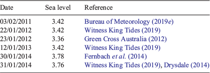
|
A1.10 Mourilyan Harbour – 3.49 m
The main population centre near Mourilyan Harbour is Innisfail, so most impact-based observations used to assess thresholds at Mourilyan Harbour are taken from Innisfail or other nearby coastal towns. Near-inundation conditions at Flying Fish Point, near Innisfail, occurred on 21 January 2011 (DERM 2011) and 23 January 2012 at the mouth of the Johnston River, near Innisfail (Green Cross Australia 2012). These king tide events were associated with hourly sea levels at Mourilyan Harbour of up to 3.28 and 3.35 m respectively but are deemed to have insufficient impact to be used as the basis for the impact-based threshold. Reported coastal inundation at Flying Fish Point on 29 January 2014 (Flynn 2014) was associated with a 3.49 m observation at Mourilyan Harbour, and the king tide on the next morning reached a record 3.73 m. A major riverine flooding event combined with a king tide to cause flooding of Innisfail in early February 2009, with a sea level of 3.53 m recorded on 7 February 2009; however, flooding impacts were reported prior to the king tide (ABC News 2009d), making determining impacts from extreme sea levels difficult. Other extreme sea levels recorded in 1997 and 2010 have been coincident with Tropical Cyclones Justin and Olga. These results suggest that an appropriate impact-based threshold for communities around Mourilyan Harbour is 3.49 m (the 29 January 2014 level), which is essentially HAT (3.5 m).
A1.11 Lucinda – 3.76 m
Inundation impacts were reported at Lucinda on both social (Amanda Steven via Facebook 2009) and news media (ABC News 2009e) in 2009, however neither provide exact dates. The ABC article was published on 23 January and the Facebook post is from 14 February so it is unclear whether the photos were from the same event or two separate events. DERM (2011) indicates that inundation occurred on 21 January 2011 at Palm Creek (26 km away) and sandbags were required in Lucinda to stop flooding. This event reached 3.76 m which is lower than both the January and February 2009 monthly maxima (4.20 and 4.09 m respectively) and hence is an appropriate impact-based threshold.
A1.12 Bowen – 3.67 m
Only two instances of coastal inundation at Bowen are known. Ortlieb (2014) reported major inundation on 30–31 January 2014 (Cyclone Dylan), whereas DERM (2011) reported minor inundation on 18 February 2011. These events corresponded with sea levels of 3.86 and 3.67 m respectively; hence, 3.67 m is defined as the impact-based threshold.
A1.13 Shute Harbour (Airlie Beach) – 4.25 m
There are reports of coastal inundation around Airlie Beach, Shute Harbour and nearby Cannonvale. Witness King Tides (2019) indicates inundation occurred on 22 January 2012 (4.26 m). Major inundation associated with Cyclone Dylan occurred on 30–31 January 2014 (Ortlieb 2014, Fernbach et al. 2014) reaching 4.79 m, the highest value on record. Inundation also occurred on 12 January 2013 at Shute Harbour, with water covering the road at a level of 4.25 m (Whitsunday Times 2013). The impact-based threshold is thus defined as 4.25 m, the 12 January 2013 level but also very close to the 22 January 2012 level, and just below HAT (4.3 m).
A1.14 Mackay (6.35 m) and Hay Point (6.81 m)
Like Townsville, Mackay is one of the locations in this study that have two gauges nearby. As a large population centre, it also has many observations of coastal inundation, which are documented in Table A1.3. The highest sea levels recorded in Mackay (6.84 m) and Hay Point (7.42 m) were associated with a storm surge that inundated homes, car parks, roads and a school on 31 January 2014 (Daily Mercury 2014 and ABC News 2014). The lowest values from this table are 6.35 m on 22 and 23 January 2012 for Mackay and 6.81 m on 18 February 2011 for Hay Point. These values define the impact-based thresholds for these gauges.
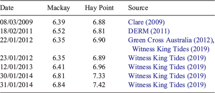
|
A1.15 Port Alma – no impact-based threshold defined
Port Alma is the only location in Queensland to have never exceeded HAT. However, a flood event on 12–13 January 2013, that did not affect the current port (McKee 2013), resulted in inundation of areas where extensions to the port are proposed (Grech et al. 2013). This event peaked at 5.54 m, well below HAT, and provides an example of how future changes to the built environment can result in impact-based thresholds changing (if impacts are reported in a future event of similar magnitude). The other high sea-level observations at Port Alma occurred on 31 January–1 February 2014, peaking at 5.90 m, the highest on record, and 20 February 2015, peaking at 5.87 m. The latter was during Tropical Cyclone Marcia and resulted in closure of the port (Queensland Reconstruction Authority 2015); however, whether this was precautionary or due to inundation is unclear. Low population in the immediate vicinity of the gauge means that this area likely has lower reporting rates than gauges in population centres. This, along with uncertainty surrounding the extent of impacts, means that Port Alma does not have a defined impact-based threshold. Even Cyclone Marcia, which made landfall near Port Alma, did not produce recorded sea-level impacts due to its coastal crossing occurring at low tide (DEHP 2017).
A1.16 Gladstone – 4.58 m
Photos of Gladstone on 22 and 24 January 2012, during a king tide event, show the water level very close to, but not reaching, walkways and foreshore areas (Green Cross Australia 2012). The daily maximum values were 4.59 and 4.62 m, which are below HAT (4.8 m). Photos depict similar conditions during the spring tide on 12 January 2013 (The Observer 2013), an event that reached a maximum of 4.58 m. However, Witness King Tides (2019) note that the 12 January 2013 event caused flooding at Boyne Island, 15 km southeast of Gladstone, suggesting that photos of Green Cross Australia (2012) may not have been taken at the locations most susceptible to coastal inundation. The Observer (2014a) published photographs of the inundation of roads and walkways on 31 January 2014. This event was the highest sea level recorded in Gladstone, at 4.99 m, and was due to Cyclone Dylan coinciding with a spring tide. This event damaged infrastructure and threatened homes along the coast near Yeppoon and Gladstone (Smith and Hughes 2014; Roberts 2014). However, The Observer (2014b) also reported damage to coastal infrastructure, caused the following day, with a maximum sea level observation of 4.87 m. Given the cyclonic conditions, it is likely that waves contributed to the coastal impacts during this event. The impact-based threshold is defined as the 12 January 2013 level of 4.58 m.
A1.17 Bundaberg – 3.46 m
Coastal inundation occurred at Bundaberg and surrounds (primarily Bargara) on 23 January 2012, 24 January 2012 and 26 January 2013 (Witness King Tides 2019). These were associated with sea levels of 3.46, 3.47 and 3.46 m, which suggests that the impact-based threshold is 3.46 m. A more severe event occurred in 2014, with News Mail (2014a) reporting that beachfront apartments in suburbs of Bundaberg had gained ‘extensive’ damage due to erosion caused by the inundation of seawater. It is likely that this damage is associated with the king tide on 30–31 January 2014 (maximum daily hourly observations of 3.58 and 3.70 m), which is supported by an earlier report by News Mail (2014b) which provides images of impacts on the 31st.
A1.18 Urangan – 4.12 m
Overtopping and damage of the sea wall at Urangan (near Hervey Bay), which inundated foreshore areas causing significant damage on 4 January 2014, when king tides combined with waves generated by strong winds (Edwards 2014; Fraser Coast Chronicle 2014). The daily maximum sea level at Urangan was 4.12 m; however, it is possible there is a large wind wave set-up and run-up component that may not be captured by the tide gauge. Inundation of foreshore areas occurred again on 20 February 2015 (Fraser Coast Chronicle 2015), although the event was minor, and there was less than expected due to lighter winds and sandbagging preventing damages (Johnson 2015). This event reached a maximum of 4.21 m. Witness King Tides (2019) note inundation of steps at Point Vernon (10 km from Urangan) on 2 January 2014 (4.23 m) and 22–23 January 2012 (4.14 m) at Urangan. This supports the use of the 4 January 2014 sea level as the impact-based threshold and suggests that although the winds may have exacerbated the damage, the sea level alone was enough for some impacts.
A1.19 Mooloolaba (Sunshine Coast) – 2.06 m
A summary of all coastal inundation events on the Sunshine Coast, primarily around Mooloolaba and Maroochydore, is provided in Table A1.4. Some impacts included closure of a major road, Bradman Avenue, at Maroochydore on 25 January 2012 (Johnston et al. 2012). Hoffman (2017) reported flooding at a number of locations on the Sunshine Coast (Mooloolaba, Maroochydore, Twin Water and Caloundra) on 21 August 2017, due to high tide forcing water up storm water drains. The lowest value with reported impacts, 2.06 m is defined as the impact-based threshold.
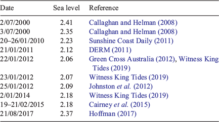
|