
Seasonal climate summary for the southern hemisphere (spring 2016): strong negative Indian Ocean Dipole ends, bringing second wettest September to Australia
Blair Trewin A B and Catherine Ganter AA Bureau of Meteorology, GPO Box 1289, Melbourne, Vic., Australia.
B Corresponding author. Email: blair.trewin@bom.gov.au
Journal of Southern Hemisphere Earth Systems Science 69(1) 273-289 https://doi.org/10.1071/ES19013
Submitted: 8 August 2019 Accepted: 7 October 2019 Published: 11 June 2020
Journal Compilation © BoM 2019 Open Access CC BY-NC-ND
Abstract
This summary looks at the southern hemisphere and equatorial climate patterns for spring 2016, with particular attention given to the Australasian and equatorial regions of the Pacific and Indian Ocean basins. Spring 2016 was marked by the later part of a strong negative phase of the Indian Ocean Dipole, alongside cool neutral El Niño–Southern Oscillation conditions. September was exceptionally wet over much of Australia, contributing to a wet spring with near-average temperatures. The spring was one of the warmest on record over the southern hemisphere as a whole, with Antarctic Sea ice extent dropping to record low levels for the season.
1 Introduction
This summary reviews the southern hemisphere and equatorial climate patterns for the 2016 austral spring (September to November), with particular attention given to the Australasian and equatorial regions of the Pacific and Indian Ocean basins. The main sources of information for this report are analyses prepared by the Australian Bureau of Meteorology, the United States National Oceanic and Atmospheric Administration (NOAA) and the Global Precipitation Climatology Center, as well as the annual State of the Climate Report published in the Bulletin of the American Meteorological Society.
2 Pacific and Indian Ocean basin climate indices
2.1 Southern Oscillation Index
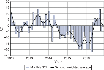
The Troup Southern Oscillation Index1 (SOI) is based on the mean sea-level pressure (MSLP) difference between Tahiti and Darwin. Sustained negative values below −7 generally indicate El Niño, whereas sustained positive values above +7 are typical of La Niña. Figure 1 shows monthly SOI values between January 2012 and November 2016, together with a 5-month weighted moving average.
|
The peak of the 2015-16 El Niño occurred in summer 2015–16 (Pepler 2016), coinciding with strong negative values of the SOI. The decay of El Niño occurred in autumn 2016 (Rosemond and Tobin 2018), with values of the SOI largely returning to the neutral range for winter and spring. The spring 2016 mean value of the SOI was +2.8, with September strongly positive at +13.5, and October and November well in the neutral range at −4.3 and −0.7 respectively.
2.2 Composite monthly El Niño–Southern Oscillation indices
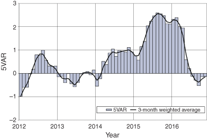
The 5VAR2 composite monthly El Niño–Southern Oscillation (ENSO) index is calculated as the standardised amplitude of the first principal component of Darwin and Tahiti MSLP and NINO3, NINO3.4 and NINO4 sea-surface temperatures3 (SSTs). Significant positive values of 5VAR (in excess of one standard deviation) are typically associated with El Niño, whereas significant negative values are indicative of La Niña.
The 5VAR index was above +2 during the 2015–16 El Niño (Fig. 2), indicating a strong event. The index then fell below +1 in May 2016, consistent with the return to a neutral ENSO state. Winter saw values close to zero, which then continued through the spring months. Monthly spring values were −0.529 for September, −0.152 for October and −0.133 for November.
|
The Multivariate ENSO Index (MEI4), produced by the Physical Sciences Division of the Earth Systems Research Laboratory (formerly known as the US Climate Diagnostics Center), is derived from six atmospheric and oceanic parameters calculated as a 2-month mean (Wolter and Timlin 1993, 1998). As with 5VAR, large negative anomalies in the MEI are usually associated with La Niña and large positive anomalies with El Niño. The September–October (−0.385) and October–November (−0.197) MEI values (not shown) were consistent with a neutral state of ENSO.
The NINO3.4 index, which measures SSTs in the central Pacific Ocean in a box covering 5°N–5°S and 120–170°W, is used by the Australian Bureau of Meteorology to monitor ENSO. NINO3.4 is closely related to the Australian climate (Wang and Hendon, 2007). NINO3.4 values were below zero throughout spring 2016, with monthly mean values of −0.6°C in September, −0.7°C in October and −0.5°C in November. These negative values fell short of the thresholds for a La Niña event to be declared by the Australian Bureau of Meteorology, although some other agencies did classify late 2016 as a weak La Niña event.
2.3 Indian Ocean Dipole
The Indian Ocean Dipole (IOD, Saji et al. 1999; Saji and Yamagata 2003) describes the pattern of SSTs over the equatorial Indian Ocean. A negative phase of the IOD is characterised by warmer than average water in the tropical eastern Indian Ocean (near Indonesia) and cooler than average water in the tropical western Indian Ocean (near the Horn of Africa). It is typically associated with increased rainfall in the eastern Indian Ocean and across southern Australia during winter–spring (Risbey et al. 2009). The opposite is true for a positive IOD.
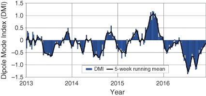
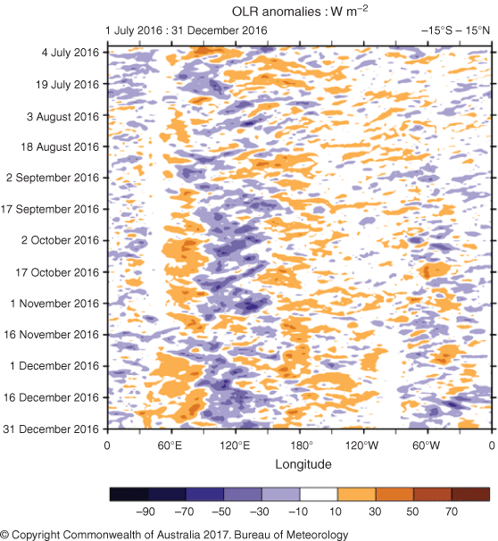
The Dipole Mode Index (DMI)5 measures the difference between the western (50–70°E and 10°S–10°N) and eastern (90–110°E and 10–0°S) nodes of the IOD. Weekly DMI values are shown in Fig. 3 between January 2013 and November 2016. The DMI dropped below −0.4°C (the threshold for a negative IOD phase) in late May 2016 and remained strongly negative throughout winter 2016 (Lim and Hendon 2017; Trewin 2018). Values were strongly negative at the start of spring, with the strongest value of −1.19°C for the week ending 11 September 2016. The negative IOD event ended at the end of October, with November weekly values all within the neutral range. This negative phase of the IOD through September and October 2016 is consistent with negative outgoing longwave radiation (OLR) anomalies across the eastern Indian Ocean and Maritime Continent in spring 2016 (Fig. 4), as well as the very wet September for Australia (see Australian rainfall Section 8). Near average to suppressed convection can also be seen over the western Indian Ocean.
|

|
3 Outgoing longwave radiation
OLR in the equatorial Pacific Ocean can be used as an indicator of enhanced or suppressed tropical convection. Increased positive OLR anomalies indicate reduced convective activity and, therefore, a reduction in cloudiness and, usually, rainfall. Conversely, negative OLR anomalies indicate enhanced convection and, therefore, increased cloudiness and rainfall. During La Niña, OLR is often increased, meaning convection is often suppressed, near the Date Line, whereas increased cloudiness (decreased OLR) near the Date Line usually occurs during El Niño. Similarly, in the Indian Ocean, if a negative IOD is in place, OLR anomalies are negative over the eastern Indian Ocean where increased convection occurs, but positive OLR over the western Indian Ocean.
In the Indian Ocean region, decreased cloudiness in the western Indian Ocean and increased cloudiness in the eastern Indian Ocean (Fig. 4) clearly indicates the presence of a negative IOD event. These conditions were most pronounced in September and October (Wang et al. 2019) but persisted for most of the spring (Fig. 5). The strongest negative OLR anomalies were in the vicinity of Christmas Island, which had by far its wettest spring on record (Section 9). There were also negative anomalies over most of the Australian continent, consistent with the wet spring (Section 8). (It should, however, be noted that OLR values currently appear to have a low bias over subtropical land areas, most likely associated with orbital decay of the GOES-18 satellite (Matthew Wheeler pers. comm.).)
|
The Hovmöller diagram of OLR anomalies along the equator during spring 2016 (Fig. 5) shows a weak positive signal near the Date Line for most of the season, potentially favouring decreased cloudiness slightly and consistent with a weak positive seasonal anomaly (Fig. 4). This signal is consistent with an ENSO cool-neutral state. Averaged over an area at the International Date Line (7.5°S–7.5°N and 160°E–160°W), the standardised monthly OLR anomaly for September was +0.9, October +1.0 and November +1.4.6
4 Madden–Julian Oscillation
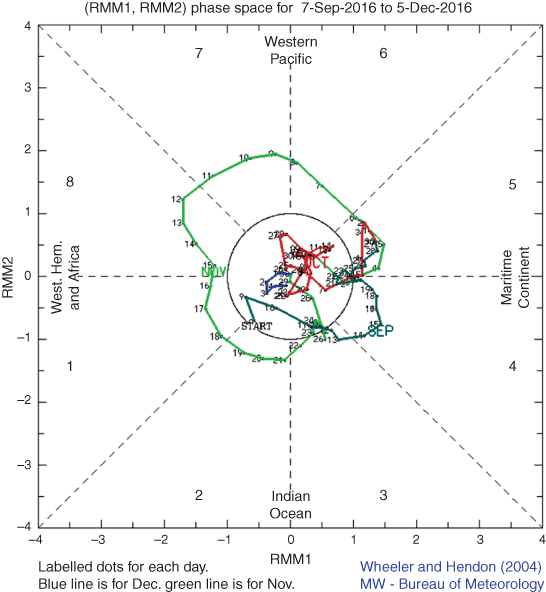
The Madden–Julian Oscillation (MJO) is a tropical convective wave anomaly which develops in the Indian Ocean and propagates eastwards into the Pacific Ocean (Madden and Julian 1971, 1972, 1994). The MJO takes ~30–60 days to reach the western Pacific, with a frequency of 6–12 events per year (Donald et al. 2004). When the MJO is in an active phase, it is associated with areas of increased and decreased tropical convection, with effects on the southern hemisphere often weakening during early autumn, before transitioning to the Northern Hemisphere. A description of the real-time multivariate MJO (RMM) index and the associated phases can be found in Wheeler and Hendon (2004).
The phase-space diagram of the RMM for spring 2016 is shown in Fig. 6. MJO activity was generally weak for most of September and October, apart from a brief active phase over the Maritime Continent in mid-September. However, an active MJO phase began in late October in the Maritime Continent sector, before progressing to the western Pacific sector through the first half of November and into phases 8 and 1 (Western Hemisphere and Africa) in the third week of November. This phase weakened towards the end of November. Such a pattern would historically have been favourable for rainfall in the first half of November in the northern tropics of the Northern Territory and Queensland (Wheeler et al. 2009), but in general only scattered rainfall typical of the season occurred.
|
5 Oceanic patterns
5.1 Sea surface temperatures
The area-averaged SST for the southern hemisphere for winter 2016 was 0.61°C7 above the 20th century average. This was the second-warmest value on record in the NOAA dataset, 0.06°C below the previous record set in 2015.
Figure 7 shows SST anomalies globally for spring 2016, relative to 1961–90, whereas Fig. 8 shows SSTs in the Australian region relative to the historical distribution. SSTs were between 0.5 and 1.0°C below average in the central equatorial Pacific, consistent with a cool neutral ENSO phase. They were above average through most other areas of the tropical and subtropical South Pacific, reaching more than 1°C above average in places. They were also at least 0.5°C above average through Maritime Continent waters and in the eastern Indian Ocean.

|

|
In the Australian region, SSTs were below average near the south-west of Western Australia, but above average in most other areas, particularly around the eastern and northern coasts. Some areas between Western Australia and Indonesia, where SSTs were generally at least 1°C above average, had their warmest spring SSTs on record, as did some areas in the tropical western Pacific. The overall Australian region8 had SSTs 0.59°C above the 1961–90 average, the third-warmest on record for spring. It was the warmest spring on record for the Coral Sea and the second-warmest for northern Australian tropical waters overall. However, it was the coolest since 2005 for the south-west Australian region.
5.2 Equatorial subsurface patterns
The 20°C isotherm depth is generally located close to the equatorial thermocline, which is the region of greatest temperature gradient with depth and is the boundary between the warm near-surface and cold deep-ocean waters. Therefore, measurements of the 20°C isotherm depth make a good proxy for the thermocline depth. Negative anomalies correspond to the 20°C isotherm being shallower than average and is indicative of a cooling of subsurface temperatures. If the thermocline anomaly is positive, the depth of the thermocline is deeper. A deeper thermocline results in less cold water available for upwelling, and therefore a warming of surface temperatures.
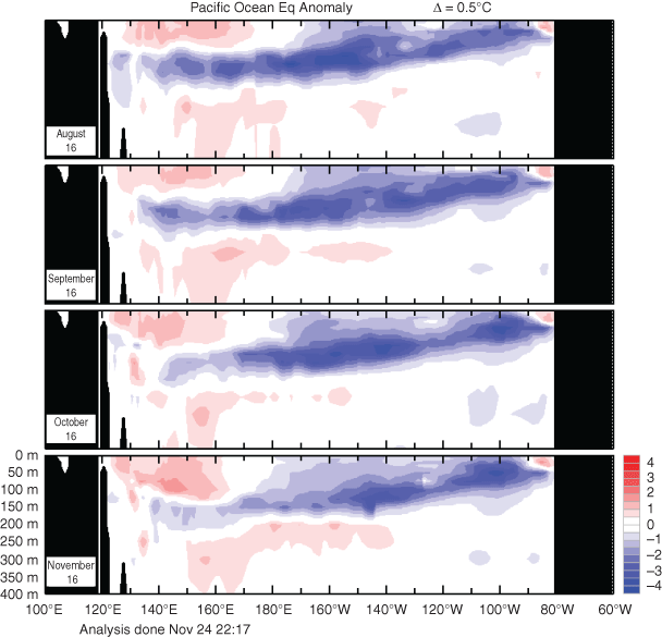
Subsurface waters had been generally cooler than average in the equatorial Pacific during the southern hemisphere winter 2016 (Fig. 9), with a shallower thermocline than usual (Lim and Hendon 2017). The anomalies in the depth of the 20°C isotherm in the equatorial Pacific weakened during spring and became near zero by November. However, cool subsurface anomalies persisted in much of the central and eastern equatorial Pacific, mostly at levels near or above the thermocline (Fig. 10), although they weakened gradually through the spring.

|
|
6 Atmospheric circulation
6.1 Southern Annular Mode
For more information on the Southern Annular Mode (SAM) index from the Climate Prediction Center (NOAA), see http://www.cpc.ncep.noaa.gov/products/precip/CWlink/daily_ao_index/aao/aao.shtml, accessed 7 May 2020.
The Southern Annular Mode was strongly positive in September (+2.333), with October neutral at −0.177, with November negative at −1.508. The September monthly value was the highest for September in the post-1979 CPC record, and the third monthly value above +2 (after March and June) to date in 2016, whereas the November value, which was reported by Wang et al. (2019) to be associated with the weakening of the stratospheric spring polar vortex, was the lowest monthly value in any month since September 2013. It is likely that the positive SAM phase contributed to the wetter conditions seen across eastern Australia during September (Hendon et al. 2007). Similarly, the drier November across parts of NSW and Queensland was likely influenced by the negative SAM state.
6.2 Surface analyses
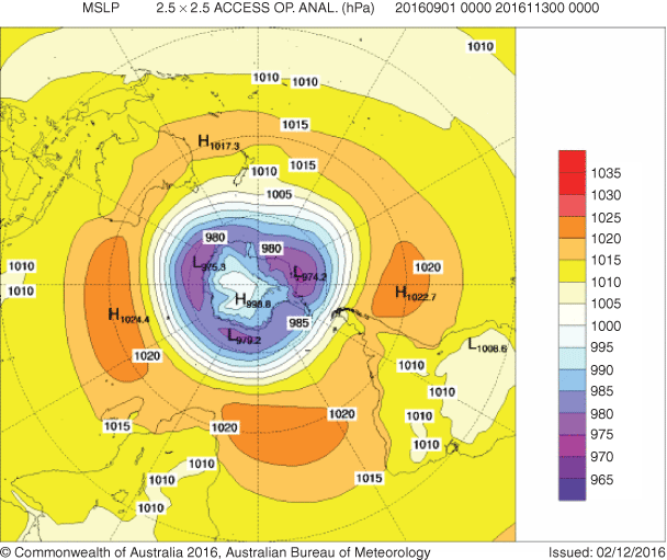
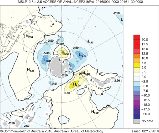
The MSLP pattern for spring 2016 is shown in Fig. 11, computed using data from the 0000 UTC daily analyses of the Bureau of Meteorology’s Australian Community Climate and Earth System Simulator (ACCESS-G) model.9 MSLP anomalies are shown in Fig. 12, relative to the 1979–2000 climatology obtained from the National Center for Environmental Prediction (NCEP) II Reanalysis data (Kanamitsu et al. 2002). The MSLP anomaly field is not shown over the areas of elevated topography (grey shading).
|
The seasonal MSLP analysis chart for spring 2016 (Fig. 11) shows a typically zonal pattern in middle and higher latitudes of the southern hemisphere, with relatively weak anomalies (Fig. 12). Low-pressure 10anomalies south of Australia are indicative of enhanced westerly flow in this sector, whereas a high-pressure anomaly near the Date Line south of New Zealand shows slight anomalous ridging in that region. Positive pressure anomalies over southern South America, and over the oceans on either side, show a subtropical ridge which is stronger and further south than usual, consistent with generally dry conditions in the region (Section 9). MSLP anomalies are weak over the Australian continent.
|
6.3 Midtropospheric analyses
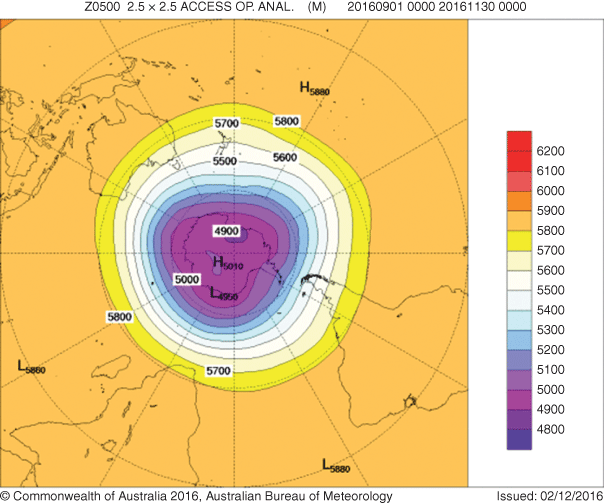
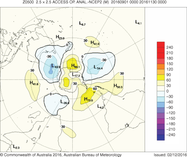
The 500-hPa geopotential height, an indicator of the steering of surface synoptic systems across the southern hemisphere, is shown for spring 2016 in Fig. 13. The associated anomalies are shown in Fig. 14.
Geopotential height is valuable for identifying and locating features like troughs and ridges which are the upper level equivalents of surface low- and high-pressure systems respectively. The major features are similar to those at the surface, with anomalous ridging south of New Zealand, positive height anomalies over a region centred on southern South America and a weak anomalous trough south of Australia. Weak positive anomalies prevailed over most tropical and subtropical areas north of 30°S.
|
|
7 Winds
Figures 15 and 16 show spring 2016 low-level (850 hPa) and upper level (200 hPa) wind anomalies respectively (winds computed from ACCESS and anomalies with respect to the 22-year 1979–2000 NCEP climatology). Isotach contours are at an interval of 5 m s−1.

|

|
Generally weak 850-hPa wind anomalies are evident through most of the southern hemisphere. In the Australian region, there are northerly anomalies over much of eastern Australia (although these were not associated with significant warm temperature anomalies at the surface) and south-westerly anomalies to the south-west of Western Australia. Easterly anomalies near 50°S indicate weaker than normal westerly flow in the western South Pacific west of ~120°W, whereas westerly anomalies in the equatorial Indian Ocean, strongest at ~90°E, are consistent with the negative IOD. Weak anomalies through most of the equatorial and tropical South Pacific are consistent with neutral ENSO conditions. 200-hPa anomalies in the southern hemisphere were also generally weak, although westerly anomalies at ~35°S near and west of Western Australia, and in the central and eastern South Pacific, were indicative of strengthened jetstreams in those longitudes.
8 Australian region
8.1 Rainfall
Spring 2016 marked the end of an exceptionally wet period over much of Australia which had begun in May. September 2016 was the second-wettest on record for Australia (195% above the 1961–90 average), just behind 2010 (Hope et al. 2018). Rainfall for the month was well above average almost everywhere outside Western Australia, except for coastal New South Wales. It was the wettest September on record for New South Wales and the Murray–Darling Basin by substantial margins and also set a record for the Northern Territory, whereas Victoria and South Australia had their second-wettest September on record and Queensland its third. Most of New South Wales west of the Great Dividing Range had its wettest September on record, as did much of western Victoria and eastern South Australia, the Top End of the Northern Territory and substantial parts of outback Queensland. The heavy rains led to widespread and significant flooding, especially in the Lachlan, Murrumbidgee and Murray catchments and parts of South Australia. The overall May to September 2016 period was easily the wettest on record for Australia, breaking the 1978 record, and also set records in Queensland, New South Wales, South Australia, Victoria and Tasmania (Bureau of Meteorology 2016).
Rainfall returned to more normal conditions in October and November, with both October (15% below average) and November (26% below average) slightly drier than average nationally. October was very wet in Tasmania, and to a lesser extent in Victoria, but saw near-to-below-average rainfall over most other parts of the country. Northern Western Australia saw unseasonable rain but monthly totals only locally exceeded 25 mm. November rainfall was near average over much of Australia, tending towards below average in the southern half of Western Australia, and in northern New South Wales and southern Queensland; the New South Wales and Queensland anomalies are consistent with November’s strongly negative SAM mode, coupled to the weakening of the stratospheric polar vortex (Lim et al. 2018). Tasmania was again rather wet, particularly near the east coast where heavy rain fell in mid-November.
Overall for the season, rainfall was above average in all states and territories except Western Australia (Fig. 17), although only Victoria and Tasmania (both 10th) had a spring in the 10 wettest (Table 1). Tasmania’s spring was its wettest since 1988, but all other States and Territories were wetter in one or both of 2010 and 2011. The extremely wet September was sufficient for rainfall to reach the highest decile in much of the eastern interior despite limited rain for the rest of the season, whereas wet conditions in September and October contributed to large areas in the highest decile in western Victoria, eastern South Australia and Tasmania. The most significant dry areas were in the southern half of Western Australia and locally on Cape York Peninsula and the North Coast of New South Wales.

|

|
8.2 Rainfall deficiencies
The heavy rainfall in winter and spring 2016 eliminated almost all remaining rainfall deficiencies in eastern Australia at timescales of 2 years or less. Outside the northern tropics, where some pockets of deficiencies reflected locally dry conditions in the 2015–16 wet season, the only remaining area of deficiencies at the 19-month timescale (Fig. 18) was a small region in south Gippsland in Victoria. In Western Australia, a few areas of deficiencies persisted near the west coast, with the largest of them near Perth (Table 2).

|

|
8.3 Temperature
Nationally, both maximum and minimum temperatures in spring 2016 were very close to the 1961–90 average. Mean temperatures were exactly equal to the 1961–90 average, making it the coolest spring since 2010; despite being slightly above average, minimum temperatures nationally were still the lowest since 2001. At the State level, New South Wales and Victoria were only slightly cooler than average but still had their coolest springs since 1993 and 2003 respectively, whereas South Australia’s minimum temperatures were the lowest since 1992.
Maximum temperatures were below average in most of the eastern interior, and above average in the northern tropics and along the east coast (Fig. 19). The most significant warmth was in the far north, where all 3 months of spring were significantly warmer than average, and some parts of the north Kimberley and Cape York Peninsula had their warmest spring on record. Cool conditions were most prominent in south-west Queensland, where mean spring maximum temperatures were locally 2–3°C below average. Minimum temperatures were well above average in the northern tropics and were also generally above average in the eastern regions of Queensland, New South Wales and Victoria, and in most of Tasmania (Fig. 20). They were below average in most of the southern half of Australia from western New South Wales westwards, with the largest anomalies (locally below −1°C) in southern Western Australia.

|

|
The most striking temperature anomalies of the season were in September. Maximum temperatures were far below average in many of the wetter parts of inland eastern Australia, with anomalies as large as −5°C in south-western Queensland. September was also exceptionally cool, both for maximum and minimum temperatures, in south-west Western Australia; it was the coolest September on record for the south-west region, with significant frost damage in places (Grose et al. 2018). October was rather cool in many areas outside the north, with record low mean minimum temperatures in parts of central Australia, whereas November saw generally average to above average temperatures.

|

|
9 Southern Hemisphere
The austral spring of 2016 was warmer than average over the southern hemisphere overall. Averages over the hemisphere as a whole, of the three major global data sets, was the second warmest in the NOAA data set (Smith and Reynolds 2005), third warmest in the National Air and Space Administration data set (Hansen et al. 2010) and fourth warmest in the United Kingdom Meteorological Office Hadley Centre – Climatic Research Unit, University of East Anglia (HadCRU) data set (Morice et al. 201211).12 The warmth was most pronounced over the oceans, with temperatures averaged over southern hemisphere land areas being the coolest since spring 2011 in the NOAA data set, although still above the 1981–2010 average.
Apart from Australia, temperatures were near average over most of subtropical South America east of the Andes, including southern Brazil, Paraguay, Uruguay and the northern half of Argentina (Fig. 21). Temperatures over land were significantly above average over most southern hemisphere parts of Africa, in much of the northern half of Brazil, in the far south of South America and in New Zealand (which had its ninth-warmest spring on record). Anomalies were generally moderate with few locations exceeding 2°C above the 1981–2010 average for the season. SSTs were below average near south-western Australia and near average in the far south-west Atlantic and the central equatorial Pacific but above average in most other Southern Hemisphere locations.

|
It was a rather dry spring in many Southern Hemisphere areas of Africa, particularly in South Africa and in tropical areas near the east coast (Fig. 21). In South America, it was dry in much of central and southern Chile (continuing an exceptionally dry year there) and in the far south of Argentina, as well as in northeast Brazil. Most other areas had near-average rainfall, although there was an area of above-average rainfall in central Argentina centred on ~40°S. Much of Indonesia was unseasonably wet. This extended to Australia’s offshore Indian Ocean islands, particularly Christmas Island, which set monthly records for all three spring months and had a total seasonal rainfall of 2067.8 mm, about seven times the long-term spring average and more than double the previous record of 923.6 mm set in 1975. Rainfall in New Zealand was mostly average to above average, whereas in the south-west Pacific, it was mostly relatively close to average (though with some local variations) with the South Pacific Convergence Zone (SPCZ) fluctuating about its normal position (Blunden and Arndt 2017).
Spring temperatures were slightly above average at Australia’s coastal Antarctic stations and at the South Pole, with a cold September at all these locations offset by above-average temperatures in October and November. Davis and Mawson both had their highest November mean maximum on record. Macquarie Island had its warmest spring on record, with slightly above-average precipitation. Antarctic sea ice extent, having been close to average for most of 2016, dropped sharply below average in September and remained well below average for all of spring, with record low monthly values in October and November (Wang et al. 2019). The 2016 Antarctic ozone hole had an average area for the 7 September–13 October period of 20.9 million km2, somewhat below the post-1991 average (Blunden and Arndt 2017).
Acknowledgements
The assistance of Eun-Pa Lim and Robert Fawcett in reviewing this manuscript is gratefully acknowledged. This research did not receive any specific funding.
References
Blunden J. Arndt D. S. (2017). State of the climate in 2016. Bull. Am. Met. Soc. 98, S1–S277.| State of the climate in 2016.Crossref | GoogleScholarGoogle Scholar |
Bureau of Meteorology (2016). Record September rains continue wet period in much of Australia. Special Climate Statement 58. (Bureau of Meteorology: Melbourne, Vic., Australia.)
Donald, A., Meinke, H., Power, B., Wheeler, M., and Ribbe, J. (2004). Forecasting with the Madden–Julian Oscillation and the applications for risk management. 4th International Crop Science Congress, Brisbane, 26 September–1 October 2004.
Grose M. R. Black M. Risbey J. S. Uhe P. Hope P. K. Haustein K. Mitchell D. (2018). Severe frosts in Western Australia in September 2016. Bull. Am. Met. Soc. 99, S150–S154.
| Severe frosts in Western Australia in September 2016.Crossref | GoogleScholarGoogle Scholar |
Hansen J. Ruedy R. Sato M. Lo K. (2010). Global surface temperature change. Rev. Geophys. 48, RG4004.
| Global surface temperature change.Crossref | GoogleScholarGoogle Scholar |
Hendon H. Thompson D. W. J. Wheeler M. C. (2007). Australian rainfall and surface temperature variations associated with the southern hemisphere annular mode. J. Clim. 20, 2452–2467.
| Australian rainfall and surface temperature variations associated with the southern hemisphere annular mode.Crossref | GoogleScholarGoogle Scholar |
Hope P. Lim E.-P. Hendon H. Wang G. (2018). The effect of increasing CO2 on the extreme September 2016 rainfall across southeastern Australia. Bull. Am. Met. Soc. 99, S133–S138.
| The effect of increasing CO2 on the extreme September 2016 rainfall across southeastern Australia.Crossref | GoogleScholarGoogle Scholar |
Huang B. Thorne P. W. Banzon V. F. Boyer T. Chepurin G. Lawrimore J. H. Menne M. J. Smith T. M. Vose R. S. Zhang H.-M. (2017). Extended Reconstructed Sea Surface Temperature, Version 5 (ERSSTv5): upgrades, validations and intercomparisons. J. Clim. 30, 8179–8205.
| Extended Reconstructed Sea Surface Temperature, Version 5 (ERSSTv5): upgrades, validations and intercomparisons.Crossref | GoogleScholarGoogle Scholar |
Kanamitsu M. Ebisuzaki W. Woollen J. Yang S.-K. Hnilo J. J. Fiorino M. Potter G. L. (2002). NCEP-DOE AMIPII Reanalysis (R-2). Bull. Am. Met. Soc. 83, 1631–1643.
| NCEP-DOE AMIPII Reanalysis (R-2).Crossref | GoogleScholarGoogle Scholar |
Kuleshov Y. Qi L. Fawcett R. Jones D. (2009). Improving preparedness to natural hazards: Tropical cyclone prediction for the Southern Hemisphere. Adv. Geosci. 12, 127–143.
Lim E.-P. Hendon H. H. (2017). Causes and predictability of the negative Indian Ocean Dipole and its impact on La Niña during 2016. Nat. Sci. Rep. 7, 12619.
| Causes and predictability of the negative Indian Ocean Dipole and its impact on La Niña during 2016.Crossref | GoogleScholarGoogle Scholar |
Lim E.-P. Hendon H. H. Thompson D. W. J. (2018). Seasonal evolution of stratosphere-troposphere coupling in the Southern Hemisphere and implications for the predictability of surface climate. J. Geophys. Res. Atmos. 123, 12002–12016.
| Seasonal evolution of stratosphere-troposphere coupling in the Southern Hemisphere and implications for the predictability of surface climate.Crossref | GoogleScholarGoogle Scholar |
Madden R. A. Julian P. R. (1971). Detection of a 40-50 day oscillation in the zonal wind in the tropical Pacific. J. Atmos. Sci. 28, 702–708.
| Detection of a 40-50 day oscillation in the zonal wind in the tropical Pacific.Crossref | GoogleScholarGoogle Scholar |
Madden R. A. Julian P. R. (1972). Description of global-scale circulation cells in the tropics with a 40-50 day period. J. Atmos. Sci. 29, 1109–1123.
| Description of global-scale circulation cells in the tropics with a 40-50 day period.Crossref | GoogleScholarGoogle Scholar |
Madden R. A. Julian P. R. (1994). Observations of the 40-50 day tropical oscillation: a review. Mon. Wea. Rev. 122, 814–837.
| Observations of the 40-50 day tropical oscillation: a review.Crossref | GoogleScholarGoogle Scholar |
Morice C. P. Kennedy J. J. Rayner N. A. Jones P. D. (2012). Quantifying uncertainties in global and regional temperature change using an ensemble of observational estimates: the HadCRUT4 dataset. J. Geophys. Res. 117, D08101.
| Quantifying uncertainties in global and regional temperature change using an ensemble of observational estimates: the HadCRUT4 dataset.Crossref | GoogleScholarGoogle Scholar |
Pepler, A. (2016). Seasonal climate summary southern hemisphere (summer 2015-16): strong El Niño peaks and begins to weaken. J. South. Hemisph. Earth Syst. Sci. 66, 361–379
Risbey J. S. Pook M. J. McIntosh P. C. Wheeler M. C. Hendon H. H. (2009). On the remote drivers of rainfall variability in Australia. Mon. Wea. Rev. 137, 3233–3253.
| On the remote drivers of rainfall variability in Australia.Crossref | GoogleScholarGoogle Scholar |
Rosemond K. Tobin S. (2018). Seasonal climate summary for the southern hemisphere (autumn 2016): El Niño slips into neutral and a negative Indian Ocean Dipole develops. J. South. Hem. Earth Syst. Sci. 68, 124–146.
| Seasonal climate summary for the southern hemisphere (autumn 2016): El Niño slips into neutral and a negative Indian Ocean Dipole develops.Crossref | GoogleScholarGoogle Scholar |
Saji N. H. Goswami B. N. Vinayachandran P. N. Yamagata T. (1999). A dipole mode in the tropical Indian Ocean. Nature 401, 360–363.
| A dipole mode in the tropical Indian Ocean.Crossref | GoogleScholarGoogle Scholar |
Saji N. H. Yamagata T. (2003). Structure of SST and surface wind variability during Indian Ocean Dipole Mode years: COADS observations. J. Clim. 16, 2735–2751.
| Structure of SST and surface wind variability during Indian Ocean Dipole Mode years: COADS observations.Crossref | GoogleScholarGoogle Scholar |
Smith T. M. Reynolds R. W. (2005). A global merged land air and sea surface temperature reconstruction based on historical observations (1880–1997). J. Clim. 18, 2021–2036.
| A global merged land air and sea surface temperature reconstruction based on historical observations (1880–1997).Crossref | GoogleScholarGoogle Scholar |
Trewin B. C. (2018). Seasonal climate summary for the southern hemisphere (winter 2016): a strong negative Indian Ocean Dipole brings wet conditions to Australia. J. South. Hem. Earth Syst. Sci. 68, 101–123.
| Seasonal climate summary for the southern hemisphere (winter 2016): a strong negative Indian Ocean Dipole brings wet conditions to Australia.Crossref | GoogleScholarGoogle Scholar |
Troup A. (1965). The southern oscillation. Q. J. Royal Met. Soc. 91, 490–506.
| The southern oscillation.Crossref | GoogleScholarGoogle Scholar |
Wang G. Hendon H. H. (2007). Sensitivity of Australian rainfall to inter-El Niño variations. J. Clim. 20, 4211–4226.
| Sensitivity of Australian rainfall to inter-El Niño variations.Crossref | GoogleScholarGoogle Scholar |
Wang G. Hendon H. H. Arblaster J. M. Lim E.-P. Abhik S. van Rensch P. (2019). Compounding tropical and stratospheric forcing of the record low Antarctic sea ice in 2016. Nat. Commun. 10, 13.
| Compounding tropical and stratospheric forcing of the record low Antarctic sea ice in 2016.Crossref | GoogleScholarGoogle Scholar |
Wheeler M. Hendon H. (2004). An all-season real-time multivariate MJO index: development of an index for monitoring and prediction. Mon. Wea. Rev. 132, 1917–1932.
| An all-season real-time multivariate MJO index: development of an index for monitoring and prediction.Crossref | GoogleScholarGoogle Scholar |
Wheeler M. C. Hendon H. H. Cleland S. Mienke H. Donald A. (2009). Impacts of the Madden-Julian Oscillation on Australian rainfall and circulation. J. Clim. 22, 1482–1498.
| Impacts of the Madden-Julian Oscillation on Australian rainfall and circulation.Crossref | GoogleScholarGoogle Scholar |
Wolter, K., and Timlin, M. S. (1993). Monitoring ENSO in COADS with a seasonally adjusted principal component index. Proc. of the 17th Climate Diagnostics Workshop, Norman, OK, NOAA/NMC/CAC, NSSL, Oklahoma Clim. Survey, CIMMS and the School of Meteorology, University of Oklahoma, pp. 52–57.
Wolter K. Timlin M. S. (1998). Measuring the strength of ENSO – how does 1997/98 rank? Weather 53, 315–324.
| Measuring the strength of ENSO – how does 1997/98 rank?Crossref | GoogleScholarGoogle Scholar |
1 The Troup Southern Oscillation Index (Troup 1965) used in this article is 10 times the standardised monthly anomaly of the difference in MSLP between Tahiti and Darwin. The calculation is based on 60-year climatology (1933–92), with records commencing in 1876. The Darwin MSLP is provided by the Bureau of Meteorology, and the Tahiti MSLP is provided by Météo France inter-regional direction for French Polynesia.
2 The 5VAR ENSO index was developed by the Bureau of Meteorology and is described by Kuleshov et al. (2009). The principal component analysis and standardisation of this ENSO index is performed over the period 1950–1999.
3 SST indices obtained from ftp://ftp.cpc.ncep.noaa.gov/wd52dg/data/indices/sstoi.indices, verified 28 April 2020.
4 Multivariate ENSO Index obtained from https://www.esrl.noaa.gov/psd/enso/mei/table.html, verified 28 April 2020. The MEI is a standardised anomaly index described in Wolter and Timlin (1993, 1998).
5 Weekly DMI values obtained from www.bom.gov.au/climate/enso/indices.shtml, verified 28 April 2020.
6 Standardised monthly OLR anomaly data obtained from http://www.cpc.ncep.noaa.gov/data/indices/olr, verified 28 April 2020.
7 NOAA National Centers for Environmental Information, Climate at a Glance: Global Time Series, published July 2019, retrieved on 29 July 2019 from http://www.ncdc.noaa.gov/cag/, verified 28 April 2020 (base period 1901–2000).
8 Defined as 4–46°S, 94–174°E. Definitions of SST regions can be found at http://www.bom.gov.au/climate/change/about/sst_timeseries.shtml, verified 28 April 2020.
9 For more information on the Bureau of Meteorology’s ACCESS model, see http://www.bom.gov.au/nwp/doc/access/NWPData.shtml, verified 28 April 2020.
10 Hovmöller plot obtained from http://www.pmel.noaa.gov/tao/jsdisplay/, verified 28 April 2020.
11 A subset of the full temperature network is used to calculate the spatial averages and rankings shown in Table 3 (maximum temperature) and Table 4 (minimum temperature); this dataset is known as ACORN-SAT (see http://www.bom.gov.au/climate/change/acorn-sat/, verified 7 May 2020, for details). These averages are available from 1910 to the present. As the anomaly averages in the tables are only retained to two decimal places, tied rankings are possible. Rankings marked with ‘=’ denote tied rankings. The tables and associated images use version 1 of ACORN-SAT as this was the version in operational use at the time.
12 These rankings use the operational data set versions as of July 2019. In some cases, the rankings differ from those reported at the time using earlier data set versions.