

Fire weather severity in southern Africa is increasing faster and more extensively in the late than in the early dry season
Sílvia Catarino A C * , João M. N. Silva A , Alana K. Neves A D , Duarte Oom B and José M. C. Pereira A
A
B
C Present address:
D Present address:
Abstract
In African savannas, the most intense fires occur during the late dry season, when fuel availability is high and atmospheric relative humidity low. The Fire Weather Index (FWI) system has been used to measure the effort required for fire suppression and explore the impact of climate on fires.
This study assesses trends in FWI system indices from 1979 to 2022 and their influence on burned area (BA).
We employed the Theil–Sen slope estimator and contextual Mann–Kendall test to evaluate the presence of significant trends in FWI system indices during the early dry season (EDS) and late dry season (LDS), and assessed how trends in BA depend on fire weather.
We found distinct patterns in fire weather trends between the EDS and LDS, the LDS showing more widespread areas of increasing trends. However, only 28% of the regression analyses showed significant relationships with BA, suggesting a moderate influence of the FWI system on BA interannual variance.
Fire weather severity is increasing faster and more extensively during the LDS than the EDS. Additional factors play a significant role in shaping BA trends. Proactively managing anthropogenic fires during the moister EDS can help mitigate fire intensity, reduce emissions and support biodiversity conservation efforts.
Keywords: burned area, contextual Mann–Kendall, fine fuel moisture content, fire danger, Fire Weather Index, FWI, Initial Spread Index, ISI, late dry season, LDS, southern Africa, spatiotemporal trends, time series.
Introduction
Savannas are a major component of the world’s vegetation, covering approximately 20% of the Earth’s land surface and contributing to 30% of the primary production of all terrestrial biomes (Grace et al. 2006; Murphy and Bowman 2012). However, they surpass all other biomes in terms of burn incidence, accounting for 75% of the global annual burned area (BA) (Archibald 2016).
Savannas are characterized by a combination of woody plants reaching a minimum height of 2 m and grasses spanning from 0.5 to 2 m (Nieman et al. 2021). The grass layer is dominated by shade-intolerant species utilizing the C4 photosynthetic pathway, which enables high rates of photosynthesis under dry atmospheric and soil conditions (Ripley et al. 2010). Owing to their high photosynthetic efficiency and effective energy storage, C4 plants can fix more carbon in warm environments compared with C3 grasses, supporting a high diversity of grazers and providing greater carbon resources for survival and regrowth after frequent fires (Ripley et al. 2010; Ratnam et al. 2011). Consequently, these species typically dominate open, warm habitats as well as areas influenced by frequent burning (Moore et al. 2019).
With a savanna area of 15.1 million km2, Africa hosts the largest expanse of savanna among all continents, covering ~50% of the land (Grace et al. 2006). Historically, African savannas have been regularly consumed by fires during the dry season, a phenomenon that has strongly shaped the structure and composition of these dynamic ecosystems over the centuries (Bond 2019). The intrinsic role of fire in maintaining the coexistence of both woody and herbaceous flora is well documented (e.g. Levick et al. 2015; Archibald et al. 2017; Devine et al. 2017) and fire-exclusion experiments have demonstrated a biome switch from savanna to forest within a few decades (Murphy and Bowman 2012).
In southern Africa, the predominant native vegetation comprises fire-resilient species (Hoffmann et al. 2012). Seedlings prioritize the growth of roots and underground storage structures to recover after fires, while most trees exhibit the ability to survive regular surface fires, swiftly regenerating their canopy multiple times (Gignoux et al. 2009). However, in the past century, fire regimes have shifted, with an increase in burn severity (Prichard et al. 2017). The most intense fires typically occur during the late dry season, characterized by the driest vegetation, heightened fuel availability and lower atmospheric relative humidity (Russell-Smith et al. 2009). These late-season fires lead to more harmful effects on residential areas, agricultural lands and native forests, contributing to deforestation and emitting gases with adverse effects on human health and the global climate (Lopes et al. 2022; Gao et al. 2023). Between 2002 and 2020, 76% of total emissions originated from the tropics, with 1072 Tg C/year coming from tropical savannas, grasslands and shrublands, and 445 Tg C/year from humid and dry forests. Furthermore, it was estimated that 36% of the BA and 29% of total greenhouse gas emissions came from southern hemisphere Africa (van Wees et al. 2022).
Angola, Zambia and Mozambique stand out as the countries with the highest fire activity in southern Africa (Archibald et al. 2010a; Russell-Smith et al. 2021), where the total BA and amount of fire emissions result from a complex interaction between climate, human activities and ecosystem processes (van der Werf et al. 2008; Russell-Smith et al. 2021). In these countries, factors such as fire size, intensity, frequency and seasonality are intricately linked to anthropogenic activities (Archibald 2016; Pereira et al. 2022). Nevertheless, the human influence on BA also depends on climatic conditions, which have a strong influence on fuel load and the spread of fires (Dube 2009).
Fire danger indices have been employed to investigate the impact of climate trends on the variability of fire occurrence and BA (Bedia et al. 2015; Silva et al. 2019). The Forest Fire Weather Index (FWI) (van Wagner 1987), a meteorologically based system developed in Canada and widely applied worldwide (van Wagner 1987; Field et al. 2015), assesses the influence of weather on fire behavior, ignition and spread, incorporating climatic data on relative humidity, temperature, wind speed and rainfall (van Wagner 1974). The FWI system is made up of various components, such as the Fine Fuel Moisture Code (FFMC) and the Initial Spread Index (ISI), and provides a numerical assessment of relative fire potential (van Wagner 1987). The Daily Severity Rating (DSR) is an extension of the FWI developed to reflect more accurately the expected fire suppression efforts (van Wagner 1987; Pearce and Moore 2004). The DSR is directly obtained from FWI through a power function and is a suitable indicator widely employed for studying fire weather changes on a seasonal time scale (van Wagner 1987).
According to Viegas et al. (1999), FWI has demonstrated superior performance in evaluating fire danger compared with other methods. A study conducted by Venäläinen et al. (2014) employed FWI data to investigate the temporal variation of forest fire danger across European countries, whereas Silva et al. (2019) examined the relationship between BA and DSR within the Iberian Peninsula. Similar studies have also been conducted in Brazil (Silva et al. 2020) and California (Goss et al. 2020), as well as globally (Bedia et al. 2015; Jain et al. 2022). Additionally, Barry et al. (2019) and Perry et al. (2019) demonstrated the effectiveness of FWI in assessing fire danger in northern African and Australian savanna ecosystems, respectively. However, despite the increasing aridity and warming of southern African savannas due to climate change (Sankaran 2019), no studies have specifically focused on this ecosystem, which is among the most severely impacted by fire.
The main goal of this study is to analyze the spatial and temporal trends in FWI system indices (specifically DSR, ISI and FFMC) and BA in southern African savannas frequently shaped by fire. Our approach involves two key aspects: (i) analyzing DSR, ISI and FFMC trends for both the early dry season (EDS) and the late dry season (LDS), using long time series based on daily data spanning the last 44 years (1979–2022); and (ii) investigating trends in BA within the same geographical region, using data obtained from MODIS (Moderate Resolution Imaging Spectroradiometer) Burned Area Monthly Global product (2001–2022). Additionally, we identified the largest clusters of significant increasing and decreasing trends in five different countries to assess the extent to which trends in FWI system indices can explain BA trends.
Data and methods
Study area
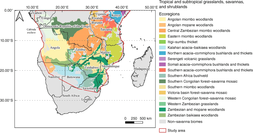
The main focus of this study is the savanna ecosystems of southern Africa, predominantly distributed across Angola, Zambia, southern Democratic Republic of Congo (DRC), Tanzania, Mozambique and Zimbabwe. African savannas are part of the Tropical and Subtropical Grasslands, Savannas and Shrublands biome, which encompasses different terrestrial ecoregions detailed in Fig. 1 (Olson et al. 2001). The study area was defined as the minimum convex polygon containing all the savanna ecoregions south of the equator, covering an area of 7,580,900 km2 in continental Africa (Fig. 1).
Study area in southern Africa, including the Tropical and Subtropical Grasslands, Savannas and Shrublands biome as defined by Olson et al. (2001).
Data acquisition
Data on precipitation were used to determine the boundary date between the EDS and the LDS, as it is recognized as the key variable for defining this threshold in southern African savannas (Eames et al. 2023). These data, originally provided by Copernicus Climate Change Service as ERA5 hourly data (Hersbach et al. 2023), were retrieved as the daily aggregated dataset (https://developers.google.com/earth-engine/datasets/catalog/ECMWF_ERA5_DAILY, last accessed 18 August 2023), through the Google Earth Engine platform, for the available period 1980–2020.
To analyze the annual rainfall pattern, we calculated the mean, minimum and maximum values for each week (7 days) throughout the year. Then, continental Africa was divided into three latitude bands (0–10°S, 10–20°S and 20–30°S), with the savanna region mostly located between 0°S and 20°S. The annual rainfall patterns and the corresponding boundary between the EDS and LDS were analyzed separately for each latitudinal band.
Data from three Forest FWI system indices, specifically the DSR, the ISI and the FFMC, were obtained from the Global Fire Weather Database (Copernicus Climate Change Service 2019) for the period 1979–2022, provided in a grid with a spatial resolution of 0.25° (approximately 27–28 km at the equator). The ISI is a numerical measure that estimates the potential rate at which a fire might spread, primarily influenced by wind speed and the moisture content of fine fuels, while the FFMC provides a numerical estimate of the moisture level in surface litter and other dry fine fuels (van Wagner 1987). It serves as an indicator of how easily these fine fuels can ignite and how flammable they are.
The DSR is directly derived from the FWI using Eqn 1, and it exhibits a more linear relationship with fireline intensity and suppression difficulty than the FWI (van Wagner 1987; Pearce and Moore 2004). The DSR is the recommended index for analyzing aggregated fire weather data in both space and time (Lawson and Armitage 2008).
Given the frequency of fires in savanna areas throughout the long dry season (Pricope and Binford 2012), we computed the annual mean DSR, ISI and FFMC values per pixel for both the EDS and LDS.
Burned area data were sourced from the MODIS burned area product MCD64A1.061 (Giglio et al. 2021), providing monthly BA information per pixel at 500 m resolution. This algorithm, relying on MODIS shortwave infrared surface reflectance bands 5 and 7, employs a burn-sensitive Vegetation Index (VI) that identifies burning events, their spatial extent and the date of burn (NASA Earth Observation Data 2023). Using the Google Earth Engine platform, we downloaded data from 2001 to 2022 (https://developers.google.com/earth-engine/datasets/catalog/MODIS_061_MCD64A1, last accessed 4 August 2023). We computed the mean percentage BA per cell (5 × 5 km) for each year, aggregating BA data as the sum of each of the 12 months (from January to December), and for both the EDS and LDS separately. The selection of a 5 × 5 km cell size ensures an optimal balance between spatial resolution and the reliability of trend analyses for BA. This resolution allows more accurate computation of mean percentages and enhances trend detection, while minimizing the occurrence of cells with no area burned (Catarino et al. 2020).
It is important to note that this product underestimates global BA, particularly owing to its limitations in detecting smaller fires and fires in croplands (Boschetti et al. 2019). MODIS also experienced periods of outage, specifically in June 2001 owing to an extended Terra outage and in August 2020 owing to an Aqua outage (Giglio et al. 2020). During these periods, there may be some inaccuracies in fire dating. However, these instances are not anticipated to impact our study, given that we are working with annual BA data. Additionally, in August 2020, MODIS Terra continued to function without interruptions.
Trend estimation and significance test
The analyses of the spatial and temporal trends of FWI system indices and BA were conducted using the TerrSet v.18.31 Earth Trends Modeler (TerrSet 2020), employing a similar method for both time series, with fire danger data covering 1979–2022 and BA covering 2001–2022. Firstly, we applied the Durbin–Watson serial correlation test (Durbin and Watson 1950) and the pre-whitening procedure of Wang and Swail (2001), to avoid serial correlation while preserving the original series trend. Secondly, we employed the Theil–Sen slope (Theil 1950; Sen 1968), a non-parametric estimator robust against outliers, which are common in time series with large interannual variations such as annual BA (Chandler and Scott 2011). The Theil–Sen slope estimator calculates the median of all possible pairwise slopes between observations, providing a reliable measure of the rate of change for each cell. Finally, the significance of the Theil–Sen slope in DSR, ISI, FFMC and BA was assessed using the contextual Mann–Kendall test (Neeti and Eastman 2011). This non-parametric test evaluates trend monotonicity and incorporates spatial contextual data. Derived from the original Mann–Kendall test (Mann 1945; Kendall 1975), the contextual Mann–Kendall test assumes that trends exhibit spatial autocorrelation between neighboring pixels and uses this feature to reduce the detection of false trends (Neeti and Eastman 2011). The integration of neighboring cells facilitates the detection of consistent trends within homogeneous regions, enhancing the reliability of the results.
Relationship between FWI system indices and BA
We analyzed the relationships between various FWI system indices (specifically DSR, ISI and FFMC) and BA, distinguishing between the EDS and LDS across 10 spatial clusters displaying significant trends in BA. We selected the largest cluster of increasing trends and the largest cluster of decreasing trends of BA in each of the five countries with extensive savanna ecosystems, namely Angola, the DRC, Tanzania, Zambia and Mozambique. These clusters are defined as the largest contiguous patches of pixels with a significant trend (significance level of 5%).
The analysis spans the period from 2001 to 2022, constrained by the availability of MODIS BA data. Given the findings on fire frequency in the region, as reported by Barbosa et al. (1999), Archibald et al. (2010b, 2016) and Catarino et al. (2020), the time series length is considered adequate for characterizing these relationships.
To robustly estimate the relationship between the FWI indices and interannual variations in BA, we employed the Theil–Sen estimator, which is particularly suitable for short time series. Subsequently, we generated time series of the residuals from these regressions and tested them for significant trends. The identification of significant trends in the regression residuals suggests that factors beyond fire weather are influencing the observed trends in BA. We derived a total of 60 regressions, resulting from the combination of five countries, two sites per country (positive and negative BA trend), two parts of the fire season (EDS and LDS) and three FWI indices.
Results
Delimitation of the early and late dry season
The mean daily precipitation, including data from 1980 to 2020, reveals distinct patterns for different latitudinal bands in Africa (Fig. 2). Within the 0–10°S latitude band, the annual mean is the highest, reaching approximately 4 mm of daily precipitation. The wettest period extends from mid-October to mid-April, with mean values exceeding 5 mm of daily precipitation. The drier season occurs between June and August when the mean precipitation remains below 2 mm per day. Mid-July is a suitable and convenient date to split the dry season into early (EDS) and late (LDS) periods.
Mean daily precipitation per week at three latitude bands in Africa, computed with ERA5 data from 1980 to 2020. The demarcation between the early dry season (EDS) and late dry season (LDS) aligns with the week positioned at the midpoint of the dry season, characterized by a mean daily precipitation of less than 1 mm.
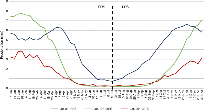
For the latitude band between 10° and 20°S, the annual mean stands at 2.8 mm of daily precipitation. In this region, precipitation is at its lowest (under 1 mm) between late April and early October. Mid-July remains an appropriate date for the EDS/LDS separation.
Moving to the latitude band between 20° and 30°S, the annual mean daily precipitation drops to 1.4 mm. However, the dry season pattern is similar to the 10–20°S latitude band, with precipitation falling below 1 mm daily from April to October. Mid-July continues to be a suitable choice for dividing the dry season in this region as well.
Based on these results, we opted to present the subsequent analyses considering the period from 15 April to 15 July as the EDS and the period from 16 July to 15 October as the LDS. Additionally, we conducted a sensitivity analysis to assess the robustness of the season boundary by considering two alternative demarcations between the EDS and LDS, specifically 1 July and 1 August. We also examined the presence of significant trends in BAs using these alternative boundaries (Supplementary Table S1).
Significant fire danger trends
Using the annual mean of daily DSR, ISI and FFMC data (1979–2022) for both the EDS (from 15 April to 15 July) and the LDS (from 16 July to 15 October), we investigated the trends in fire danger during these distinct periods in southern Africa. Additional boundary dates were analyzed to assess the robustness of the selected dates, specifically 1 July and 1 August (Supplementary Table S1).
In the EDS (Fig. 3a), areas exhibiting significant increasing trends in DSR cover 2,503,613 km2 (Supplementary Table S1). These areas are mainly located in the northern region of the study area, including the DRC, the northernmost parts of Angola, eastern Tanzania and northeastern Mozambique. The areas with the strongest trends, indicated by the highest Z-scores, were found in the DRC and Tanzania. The only area with a significant decreasing trend encompasses 44,059 km2 and is found in western Angola, corresponding to the high-altitude escarpment region also known as the Western Angolan Scarp, which is a region situated between the coastal plains and the interior plateaus characterized by its hilly terrain and significant topographic relief. In the LDS, the area exhibiting significant increasing trends in DSR dramatically expands to 5,239,202 km2, covering nearly the entire southern region of the study area. The DRC maintains very high values, whereas Tanzania shows a slight decrease. Angola also exhibits very high values, especially in the south. Zambia and Mozambique also have several regions with significantly increasing trends. Simultaneously, the area with significantly decreasing trends expands to 170,534 km2, encompassing northwestern Angola and the Cabinda exclave.
Trends of the (a) DSR, (b) ISI, and (c) FFMC in the early dry season (15 April–15 July) and in the late dry season (16 July–15 October) in southern Africa for the 1979–2022 period. The positive Contextual Mann–Kendall (CMK) Z-scores (orange) correspond to areas of increasing trends of DSR, while the negative Z-scores (blue) correspond to decreasing trends. The areas with significant trends (with a significance level of 5%) were identified with the contextual Mann–Kendall test and are outlined with black lines.
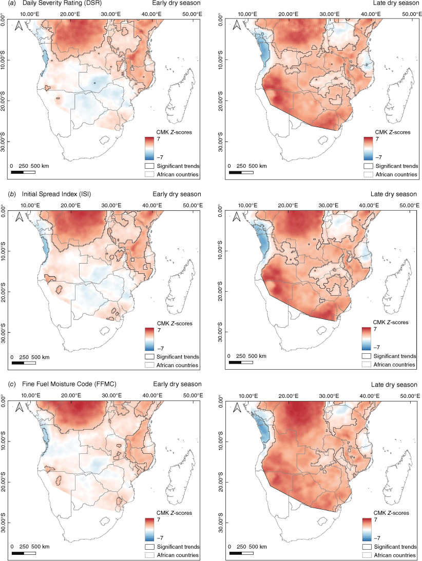
The analysis of ISI and FFMC trends revealed temporal and spatial patterns very similar to those observed for DSR. Significant increasing trends in ISI cover 2,556,910 km2 during the EDS, expanding to 5,222,472 km2 during the LDS (Fig. 3b, Supplementary Table S1). The area with significant decreasing trends in ISI also grows from 58,337 km2 in the EDS to 186,040 km2 in the LDS.
For FFMC, the trend analysis reveals a slightly smaller area of increasing trends during the EDS, with 2,116,704 km2, which expands to 5,733,104 km2 in the LDS (Fig. 3c, Supplementary Table S1). Similarly, the area with significant decreasing trends in FFMC increases from 50,028 km2 in the EDS to 173,602 km2 in the LDS.
To assess the robustness of the date selected to split the dry season into EDS and LDS, we also analyzed the trends in the FWI system indices using two alternative split dates, 1 July (Supplementary Fig. S1) and 1 August (Supplementary Fig. S2). The areas with significant trends show a slight increase when the dry season is divided later (Supplementary Table S1), but the Theil–Sen slope values maintain very similar patterns across the different dates (Supplementary Fig. S3).
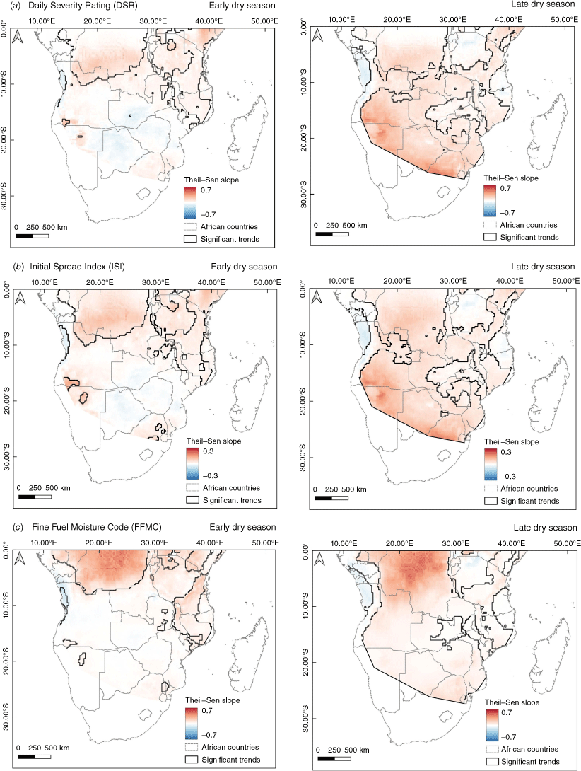
The rate of change for each cell was determined using the Theil–Sen slope estimator (Theil 1950; Sen 1968), and the results are presented in Fig. 4. During the EDS, DSR and ISI slope values remained relatively low, with DSR ranging from a maximum of 0.30 to a minimum of −0.11 units/year, and ISI ranging from a maximum of 0.15 to a minimum of −0.04 units/year (Fig. 4a and b). In the LDS, negative slope values remained stable at −0.12 DSR units/year and −0.05 ISI units/year, while positive values increased, reaching up to 0.48 DSR units/year and 0.20 ISI units/year. The FFMC displayed a distinct spatial pattern, with higher values concentrated in the DRC during both the EDS and LDS (Fig. 4c). The EDS and LDS exhibited very similar values: in the EDS, a maximum of 0.50 and a minimum of −0.16 FFMC units/year were observed, whereas in the LDS, the maximum was slightly higher at 0.51 and the minimum slightly lower at −0.12 FFMC units/year.
Theil-Sen slope values of (a) DSR (DSR units/year), (b) ISI (ISI units/year), and (c) FFMC (FMC units/year) in the early dry season (15 April–15 July) and the late dry season (16 July–15 October) in southern Africa for the 1979–2022 period. The areas with significant trends (with a significance level of 5%) were identified with the contextual Mann–Kendall test and are outlined with black lines.
Burned area and its trends
The mean annual BA percentage per cell (5 × 5 km) for the period 2001–2022 is shown in Fig. 5a. Within the study area, cells with more than 80% area burned account for 173,600 km2, while those with a burn percentage between 50 and 80% cover 774,770 km2.
Spatial patterns of burned area for the 2001–2022 period: (a) mean annual fraction of burned area in each cell (5 km resolution); (b) significant trends of the annual burned area. The positive Z-scores (orange) correspond to areas of increasing trends of burned area, while the negative Z-scores (blue) correspond to decreasing trends. Only the areas with significant trends identified with the contextual Mann-Kendall test (at a significance level of 5%) are represented in this figure. The clusters with significant trends in burned area selected for regression analyses are outlined in black.
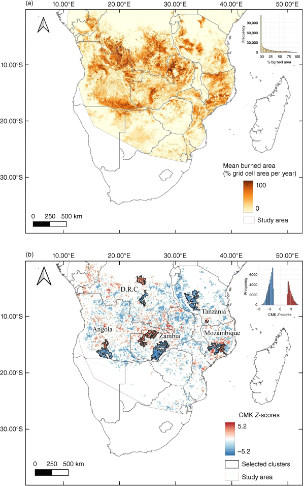
In southern Africa, Angola, DRC, Zambia, Mozambique and Tanzania exhibit the highest proportions of BA. In Angola, the northeastern region is the most affected, but extensive areas with high annual BA percentages are also observed in the southeast. DRC records a high percentage of burning in its southern regions, near the border with Angola, connecting with northeastern Angola provinces. Northeast Zambia also experiences substantial burning, whereas Tanzania has several regions with high BA percentages scattered throughout the country. Mozambique shows a high percentage of BA, mainly concentrated in the northern half of the country.
The highest mean percentages of annual BA are strongly associated with the miombo woodland ecoregions, specifically the Central Zambezian Miombo, Eastern Miombo and Angolan Miombo. Additionally, Zambezian Baikiaea woodlands and the Southern Congolian forest–savanna mosaic also encompass some regions with very high percentages of mean BA (Fig. 5a).
The significant trends in BA, as identified by the contextual Mann–Kendall test, are presented in Fig. 5b. Our findings reveal that 10.51% of the study area (796,751 km2) is experiencing significantly decreasing trends in BA, while 5.61% (425 288 km2) correspond to significantly increasing trends. The orange-red cells with positive Z-values represent increasing trends, mainly located in Congo, central Angola, northwestern Zambia and northern Mozambique. Conversely, the blue cells with negative Z-values represent decreasing trends and are mainly found in northeast and southeast Angola, southeast DRC, western Tanzania, southern and eastern Zambia, and northern Mozambique.
Relationship between annual BA and fire danger
To explore the relationship between the annual BA and the fire danger, we performed linear regression analyses using the FWI system indices as the independent variable and percentage annual BA as the dependent variable for both the EDS and the LDS (Supplementary Figs S4–S9). We selected the largest cluster of increasing trends and the largest clusters of decreasing trends in BA in each country, as presented in Fig. 5b.
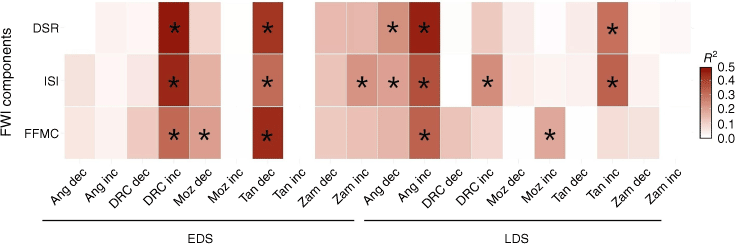
Of the 60 regression analyses modeling BA as a function of FWI indices, 17 displayed significant relationships between the variables (Fig. 6). Table 1 shows their distribution by country, dry season period and the different indexes of the FWI system. Angola and Tanzania have the most significant regressions, with five each. All of the Angolan significant regression are from the LDS. Overall, the number of significant regressions is well balanced between the EDS and LDS. The ISI, which combines the FFMC with wind speed (van Wagner 1987) accounts for seven significant regressions, while the DSR and FFMC have five each. Almost two-thirds (11) of the clusters with significant relationships display increasing BA trends.
Heat map showing the relationship between burned area and Fire Weather Index system for different clusters in southern Africa. The vertical axis represents the FWI system indices, while the clusters categorized by decreasing (dec) and increasing (inc) trends in burned area during the early dry season (EDS) and late dry season (LDS) are shown along the horizontal axis. Significant relationships (P < 0.05) are highlighted with an asterisk (*) (Ang, Angola; Moz, Mozambique; Tan, Tanzania; Zam, Zambia).
| Angola | DRC | Mozambique | Tanzania | Zambia | Total | |||
|---|---|---|---|---|---|---|---|---|
| EDS | DSR | – | 1 | – | 1 | – | 2 | |
| ISI | – | 1 | – | 1 | 1 | 3 | ||
| FFMC | – | 1 | 1 | 1 | – | 3 | ||
| Total | – | 3 | 1 | 3 | 1 | 8 | ||
| LDS | DSR | 2 | – | – | 1 | – | 3 | |
| ISI | 2 | 1 | – | 1 | – | 4 | ||
| FFMC | 1 | – | 1 | – | – | 2 | ||
| Total | 5 | 1 | 1 | 2 | – | 9 | ||
| Grand Total | 5 | 4 | 2 | 5 | 1 | 17 |
In 14 out of the 17 clusters with significant relationships between the variables, BA increases with rising FWI component values, while in the remaining three clusters, it decreases. Two of these exceptions are located in the Zambezian Baikiaea woodlands of southern Angola (Supplementary Figs S10 and S11), and the third is in the Mozambique Eastern Miombo woodlands (Supplementary Fig. S12). The FWI system indices explain only moderate to small portions of the variance in BA, resulting in significant trends in regression residuals in all except three cases (Supplementary Figs S10–S12). This indicates that factors beyond fire weather are contributing to the observed BA trends. Notably, whenever significant, the trend in the regression residuals consistently aligns with the original BA trend, showing that even if fire weather were constant over the period under analysis, BA would be trending the same way, albeit at a lower rate.
Discussion
This study presents a comprehensive investigation into the spatial and temporal trends in fire danger and BA in southern Africa. To the best of our knowledge, it is the first in-depth research on these topics specifically focused on African savannas. Our analysis utilizes long time series to investigate the trends, covering a period of more than four decades for FWI system indices and more than two decades for BA. To identify significant trends, we employed a contextual statistical technique that relies on the principle of spatial autocorrelation (Neeti and Eastman 2011). This methodology enhances our ability to identify larger and more homogeneous clusters with significant trends compared with non-contextual techniques, as demonstrated in previous studies (e.g. Silva et al. 2019; Catarino et al. 2020; Otón et al. 2021).
The analyses of fire danger indices have revealed a significant and worrying increasing trend during the dry season. A comparative assessment between the two periods of the dry season (EDS and LDS) has unveiled striking disparities in the extent affected by significant trends of fire danger indices. Notably, these increasing trends are substantially stronger and more extensive during the latter period, encompassing most of southern Africa and including the countries currently experiencing the highest levels of fire activity, such as Angola, Mozambique and Zambia (Archibald et al. 2010a). This pattern is particularly concerning as it coincides with the period when vegetation is at its driest, promoting more intense fires that generate significantly higher levels of aerosol and greenhouse gas emissions, with harmful impacts on biodiversity, human populations and the environment (Laris et al. 2020).
In the case of BA, the majority of significant trends were observed within the savanna region, spanning from 0° to 20°S latitude, whereas trends of FWI system indices covered mainly the southern part of the study area during the LDS. The lower fraction of BA and the limited presence of significant trends below the 20°S latitude mark were expected outcomes, as this region experiences lower annual precipitation levels, which, in turn, restrict vegetation growth and limit the occurrence of fires. As highlighted by Archibald et al. (2010a), in southern African savannas, the occurrence of fires is predominantly constrained by environmental factors, and fires are less likely to occur in regions with annual rainfall below 340 mm.
Another noteworthy pattern observed, particularly in Angola, the southern regions of the DRC, Zambia and Tanzania, is the overlap between areas with the highest percentages of BA per cell and the clusters exhibiting decreasing trends. Conversely, regions displaying increasing trends in BA appear to align with areas that had a low mean percentage of burning between 2001 and 2022. This observation suggests that regions experiencing increasing trends in BA may have had intensified burning in recent years, while regions that were already frequently burned and had a high mean fraction of BA have experienced a decline in fire incidence. This phenomenon could be related to shifts in agricultural and pastoral practices, as suggested by Zubkova et al. (2019), who found that 31.7% of the total decline in BA between 2002 and 2016 occurred in croplands and was associated with grazing activity.
In contrast to fire danger indices, the significant trends of BA present a highly scattered and heterogeneous distribution, alternating between positive and negative values within small regions. This pattern, previously identified in a study conducted in Angola (Catarino et al. 2020), suggests a significant anthropogenic effect on vegetation management through the use of fire. This is notable as climatic drivers typically display much smoother geographical variation.
To investigate the relationship between BA trends and FWI system indices, we performed a linear regression analysis in 10 different clusters located in savanna ecosystems. An FWI component was a significant predictor of area burned in only 28% of the 60 regression analyses performed. Previous studies on fire in Africa have reported low interannual variability in fire incidence (Archibald et al. 2010b; Pereira et al. 2022), suggesting that meteorological conditions during the dry season generally do not constrain fire occurrence and spread. This highlights the critical role of fire as a regularly employed land management tool (Pereira et al. 2015). Indeed, fire ignition is strongly related to land use in Africa, as fire is extensively employed to clean the land for traditional agriculture, promote the growth of new pastures and improve visibility for hunting (Dube 2009; Archibald 2016). The human influence on fire has been well documented in various studies conducted in Africa (e.g. Pereira et al. 2015; Harris et al. 2023; Liu et al. 2023). Pereira et al. (2015) identified a clear relationship between religion and weekday, revealing distinct weekly burning patterns in Christian and Muslim regions. The study found that in croplands, fire activity is significantly lower on Sundays in Christian areas and on Fridays in Muslim areas. In contrast, no notable differences in fire activity were observed throughout the week in rangelands and natural regions, where fire use is less regulated. These findings emphasize the influence of human activity on the seasonal patterns of global vegetation burning. Additionally, Archibald (2016) and Pereira et al. (2022) documented the substantial influence of human communities on fire characteristics in Africa such as the number and size of fires, fire intensity, fire frequency and seasonality. These factors likely explain why the relationship between FWI system indices and area burned was not significant in most cases analyzed.
The primary aim of this study is to evaluate trends in fire weather conditions during the EDS and LDS across southern hemisphere Africa. Our analysis of the relationships between FWI system indices and BA at 10 clusters within the savanna biome is similarly constrained by the dry season time frame. However, the extent of BA in African savannas is influenced not only by the degree of fuel drying and conditions for fire spread during the dry season, but also by fuel growth during the preceding wet season(s). This factor is especially critical in grasslands and shrublands, where a substantial portion of the fine fuel available for burning in the dry season accumulates over the most recent wet season. Although our regression analyses directly address the influence of contemporary fire weather on the area burned during the EDS and the LDS, they do not account for the conditions affecting fuel growth in the antecedent wet season. However, this effect is indirectly captured, as evidenced by some inverse relationships found where more severe fire weather is associated with decreased area burned.
Seven of the ten clusters with significant BA trends are located in miombo woodlands, two in the forest-savanna mosaic of southern DRC, and one in the Zambezian Baikiaea woodlands of southern Angola. The latter cluster occurs in a semi-arid area (Zomer et al. 2022), where the vegetation is primarily dominated by grassland and shrubland (Huntley 2023). The significant relationships observed between FWI system indices and BA vary by vegetation type, in a manner consistent with the variable constraints hypothesis proposed by Krawchuk and Moritz (2011) and the fire–productivity relationships described by Pausas and Ribeiro (2013). In the miombo woodlands and forest–savanna mosaic, where net primary productivity (NPP) ranges from 900 to 1600 g C/m2 year (Campbell 1996), plant fuels are consistently available for burning during the dry season, making fuel moisture the key constraint on area burned. In contrast, in the drier Zambezian Baikiaea woodlands of southern Angola, where NPP ranges from 200 to 300 g C/m2 year (Atlas of the Biosphere, based on Kucharik et al. 2000), fuel moisture during the dry season does not inhibit fire occurrence, which may instead be constrained by fuel availability, particularly in drier years. Our analyses support these ecological relationships: in the miombo and forest–savanna mosaic clusters, BA increases with higher FWI component values, whereas in the Zambezian Baikiaea woodlands, more severe fire weather is associated with a decrease in BA. Thus, increasing fire weather severity due to climate change is expected to lead to greater areas burned in the more humid and productive savanna ecoregions of southern Africa, while the opposite trend is likely in drier, low-productivity ecoregions.
Given the similar performance of the three FWI system indices in terms of extent and magnitude of trends detected, large differences in their relationship with BA were unlikely. However, the slight predominance of the ISI as the FWI component most frequently associated with significant fire weather–burned area relationships may be due to its particular suitability for estimating the risk of fast-spreading fires in fine fuels, a common scenario in southern hemisphere African savannas (Artés et al. 2019).
Management implications
Given the strong human influence on fire, the distinct trend patterns observed between the EDS and the LDS offer a valuable opportunity to reduce fire emissions and support adaptation in the face of increasing climatic change through improved land management. The EDS, characterized by moisture vegetation, usually generates smaller and less intense fires with less emissions released into the atmosphere, along with other benefits such as prevention of forest degradation and the enhancement of food security (Russell-Smith et al. 2009). Shifting towards lower-severity EDS fires could have significant implications for biodiversity. Compared with the more destructive LDS fires, EDS fires allow a greater survival rate of trees and shrubs (Geldenhuys 1977). Although some tree species in savannas are fire-resistant, frequent and intense LDS fires can lead to high tree mortality, preventing their successful regeneration (De Cauwer and Mertens 2018). By reducing fire severity, EDS fires may mitigate this impact. This approach could be particularly beneficial in regions like Angola, where high rates of deforestation and the conversion of woodlands to grasslands pose serious environmental challenges (Catarino et al. 2020).
Russell-Smith et al. (2021) have already promoted the reduction of savanna burning emissions in southern Africa by implementing strategic prescribed burning during the EDS. Their assessment, based on preliminary field trials, demonstrates the technical feasibility of this approach. By adopting informed fire management practices and intentionally shifting fires from the LDS to the EDS, it becomes possible to reduce fire intensity, bringing numerous benefits to rural populations and nature conservation. A similar strategy has proved successful in northern Australia to reduce emissions from savanna fires (Russell-Smith et al. 2013). By shifting the intentional fires from 7.6% of the area burned during the EDS and 32% of the area burned in the LDS to 20.9% of the area burned in the EDS and only 10.9% burned in the LDS, the project achieved a mean annual emissions reduction of 37.7% over the first 7 years of implementation compared with baseline emissions (Russell-Smith et al. 2013). Lipsett-Moore et al. (2018) have proposed the implementation of the same strategy in other savanna countries, including 29 in Africa. According to their study, the 20 less-developed countries in Africa account for ~74% of the global mitigation potential, with an expected reduction of 60.2 Mt of carbon dioxide equivalent (CO2-e) per year.
Although prescribed burning during the EDS has been widely recognized as an effective strategy to reduce fire emissions, it is essential to account for intra-seasonal differences in emission factors across various savanna types (Vernooij et al. 2021). Recent studies on savanna burning have shown that greenhouse gas emissions can vary significantly depending on vegetation type and tree cover density (Vernooij et al. 2023). As a result, even though there is seasonal variability in emission factors, the reductions achieved by EDS burning may outweigh any increases in emissions later in the season. Vernooij et al. (2023) found that more wood-dominated savannas, such as the miombo woodlands and forest–savanna mosaics, tend to exhibit higher modified combustion efficiency during the LDS, with corresponding lower CO and CH4 emissions compared with grass-dominated savannas, like Baikiaea woodlands and Zambezian grasslands. This reinforces the importance of considering intra-seasonal variations in emission factors and adapting prescribed burning strategies to the specific savanna type.
Thus, a comprehensive understanding of past and current fire patterns and drivers is essential for developing sustainable strategies for fire and vegetation management under a changing climate. This knowledge enables authorities to allocate resources and plan fire ignitions with greater efficiency. Moreover, involving local communities in fire management is critical, considering the significant role of human activities and the unique characteristics of the region. Local knowledge and proactive participation can enhance fire management strategies and increase the success of these actions. Furthermore, collaborative efforts across countries can play a crucial role in implementing effective fire management strategies and achieving emissions reduction through coordinated action.
Data availability
The data that support this study will be shared on reasonable request to the corresponding author.
Declaration of funding
This research was supported by the Project Feasibility Study and other Support for ISFMI to deliver a Contract with FAO Angola, titled ‘Development of a Full Proposal focused on Traditional Fire Management (TFM) that will comply with Green Climate Fund Standards and Guidelines’, funded by the International Savanna Fire Management Initiative (ISFMI), Australia. Additionally, this research was supported by the Forest Research Centre, a research unit funded by Fundação para a Ciência e a Tecnologia I.P. (FCT), Portugal (UIDB/00239/2020 – DOI: 10.54499/UIDB/00239/2020 and UIDP/00239/2020 – DOI: 10.54499/UIDP/00239/2020).
Acknowledgements
The authors are grateful to Jeremy Russell-Smith for helpful discussions and guidance.
References
Archibald S (2016) Managing the human component of fire regimes: lessons from Africa. Philosophical Transactions of the Royal Society B: Biological Sciences 371, 20150346.
| Crossref | Google Scholar |
Archibald S, Scholes RJ, Roy DP, Roberts G, Boschetti L (2010a) Southern African fire regimes as revealed by remote sensing. International Journal of Wildland Fire 19, 861-878.
| Crossref | Google Scholar |
Archibald S, Nickless A, Govender N, Scholes RJ, Lehsten V (2010b) Climate and the inter‐annual variability of fire in southern Africa: a meta‐analysis using long‐term field data and satellite‐derived burnt area data. Global Ecology and Biogeography 19, 794-809.
| Crossref | Google Scholar |
Archibald S, Beckett H, Bond WJ, Coetsee C, Druce DJ, Staver CA (2017) Interactions between fire and ecosystem processes. In ‘Conserving Africa’s Megadiversity in the Anthropocene: The Hluhluwe–iMfolozi Park story’. (Eds JP Cromsigt, S Archibald, N Owen-Smith) pp. 233–262. (Cambridge University Press: Cambridge)
Artés T, Oom D, De Rigo D, Durrant TH, Maianti P, Libertà G, San-Miguel-Ayanz J (2019) A global wildfire dataset for the analysis of fire regimes and fire behaviour. Scientific Data 6, 296.
| Crossref | Google Scholar |
Barbosa PM, Stroppiana D, Grégoire JM, Pereira JMC (1999) An assessment of vegetation fire in Africa (1981–1991): burned areas, burned biomass, and atmospheric emissions. Global Biogeochemical Cycles 13, 933-950.
| Crossref | Google Scholar |
Barry MB, Badiane D, Sall SM, Diakhaté M, Senghor H (2019) Fire activity and their relationship with the global fire weather index database components in Guinea. Environmental Management and Sustainable Development 8, 18-41.
| Crossref | Google Scholar |
Bedia J, Herrera S, Gutiérrez JM, Benali A, Brands S, Mota B, Moreno JM (2015) Global patterns in the sensitivity of burned area to fire-weather: implications for climate change. Agricultural and Forest Meteorology 214, 369-379.
| Crossref | Google Scholar |
Boschetti L, Roy DP, Giglio L, Huang H, Zubkova M, Humber ML (2019) Global validation of the Collection 6 MODIS burned area product. Remote Sensing of Environment 235, 111490.
| Crossref | Google Scholar |
Catarino S, Romeiras MM, Figueira R, Aubard V, Silva JM, Pereira JM (2020) Spatial and temporal trends of burnt area in Angola: implications for natural vegetation and protected area management. Diversity 12, 307.
| Crossref | Google Scholar |
Copernicus Climate Change Service (2019) Fire danger indices historical data from the Copernicus Emergency Management Service. In ‘Copernicus Climate Change Service (C3S) Climate Data Store (CDS)’. (Copernicus Programme: Brussels, Belgium) 10.24381/cds.0e89c522. [verified 4 July 2024]
De Cauwer V, Mertens J (2018) Impact of fire on the Baikiaea woodlands. In ‘Climate Change and adaptive land management in southern Africa – assessments, changes, challenges, and solutions’. (Eds R Revermann, KM Krewenka, U Schmiedel, JM Olwoch, J Helmschrot, N Jürgens) pp. 334–335. (Biodiversity & Ecology, Klaus Hess Publishers: Windhoek) 10.7809/b-e.00342
Devine AP, McDonald RA, Quaife T, Maclean IM (2017) Determinants of woody encroachment and cover in African savannas. Oecologia 183, 939-951.
| Crossref | Google Scholar |
Dube OP (2009) Linking fire and climate: interactions with land use, vegetation, and soil. Current Opinion in Environmental Sustainability 1, 161-169.
| Crossref | Google Scholar |
Durbin J, Watson GS (1950) Testing for serial correlation in least squares regression. Biometrika 37, 409-428.
| Crossref | Google Scholar |
Eames T, Vernooij R, Russell-Smith J, Yates C, Edwards A, van der Werf GR (2023) Division of the tropical savanna fire season into early and late dry season burning using MODIS active fires. International Journal of Applied Earth Observation and Geoinformation 125, 103575.
| Crossref | Google Scholar |
Field RD, Spessa AC, Aziz NA, Camia A, Cantin A, Carr R, de Groot WJ, Dowdy AJ, Flannigan MD, Manomaiphiboon K, Pappenberger F, Tanpipat V, Wang X (2015) Development of a Global Fire Weather Database. Natural Hazards and Earth System Sciences 15, 1407-1423.
| Crossref | Google Scholar |
Gao Y, Huang W, Yu P, Xu R, Yang Z, Gasevic D, Ye T, Guo Y, Li S (2023) Long-term impacts of non-occupational wildfire exposure on human health: a systematic review. Environmental Pollution 320, 121041.
| Crossref | Google Scholar |
Geldenhuys CJ (1977) The effect of different regimes of annual burning on two woodland communities in Kavango. South African Forestry Journal 103, 32-42.
| Crossref | Google Scholar |
Giglio L, Justice C, Boschetti L, Roy D (2021) MODIS/Terra+Aqua Burned Area Monthly L3 Global 500m SIN Grid V061 [Data set]. (NASA EOSDIS Land Processes Distributed Active Archive Center). 10.5067/MODIS/MCD64A1.061 [verified 4 August 2023]
Gignoux J, Lahoreau G, Julliard R, Barot S (2009) Establishment and early persistence of tree seedlings in an annually burned savanna. Journal of Ecology 97, 484-495.
| Crossref | Google Scholar |
Goss M, Swain DL, Abatzoglou JT, Sarhadi A, Kolden CA, Williams AP, Diffenbaugh NS (2020) Climate change is increasing the likelihood of extreme autumn wildfire conditions across California. Environmental Research Letters 15, 094016.
| Crossref | Google Scholar |
Grace J, Jose JS, Meir P, Miranda HS, Montes RA (2006) Productivity and carbon fluxes of tropical savannas. Journal of Biogeography 33, 387-400.
| Crossref | Google Scholar |
Harris LB, Taylor AH, Kassa H, Leta S, Powell B (2023) Humans and climate modulate fire activity across Ethiopia. Fire Ecology 19, 15.
| Crossref | Google Scholar |
Hersbach H, Bell B, Berrisford P, Biavati G, Horányi A, Muñoz Sabater J, Nicolas J, Peubey C, Radu R, Rozum I, Schepers D, Simmons A, Soci C, Dee D, Thépaut J-N (2023) ‘ERA5 hourly data on single levels from 1940 to present.’ (Copernicus Climate Change Service (C3S) Climate Data Store (CDS)). 10.24381/cds.adbb2d47 [verified 25 August 2023]
Hoffmann WA, Geiger EL, Gotsch SG, Rossatto DR, Silva LC, Lau OL, Haridasan M, Franco AC (2012) Ecological thresholds at the savanna–forest boundary: how plant traits, resources and fire govern the distribution of tropical biomes. Ecology Letters 15, 759-768.
| Crossref | Google Scholar |
Jain P, Castellanos-Acuna D, Coogan SC, Abatzoglou JT, Flannigan MD (2022) Observed increases in extreme fire weather driven by atmospheric humidity and temperature. Nature Climate Change 12, 63-70.
| Crossref | Google Scholar |
Krawchuk MA, Moritz MA (2011) Constraints on global fire activity vary across a resource gradient. Ecology 92, 121-132.
| Crossref | Google Scholar |
Kucharik CJ, Foley JA, Delire C, Fisher VA, Coe MT, Lenters JD, Young-Molling C, Ramankutty N, Norman J, Gower ST (2000) Testing the performance of a dynamic global ecosystem model: water balance, carbon balance, and vegetation structure. Global Biogeochemical Cycles 14, 795-825.
| Crossref | Google Scholar |
Laris P, Jacobs R, Koné M, Dembélé F, Rodrigue CM (2020) Determinants of fire intensity in working landscapes of an African savanna. Fire Ecology 16, 1-16.
| Crossref | Google Scholar |
Levick SR, Baldeck CA, Asner GP (2015) Demographic legacies of fire history in an African savanna. Functional Ecology 29, 131-139.
| Crossref | Google Scholar |
Lipsett-Moore GJ, Wolff NH, Game ET (2018) Emissions mitigation opportunities for savanna countries from early dry season fire management. Nature Communications 9, 2247.
| Crossref | Google Scholar |
Liu Z, Eden JM, Dieppois B, Conradie WS, Blacket M (2023) The April 2021 Cape Town wildfire: has anthropogenic climate change altered the likelihood of extreme fire weather? Bulletin of the American Meteorological Society 104, 298-304.
| Crossref | Google Scholar |
Lopes D, Menezes I, Fernandes AP, Gama C, Sorte S, Reis J, Monteiro A, Borrego C, Miranda AI (2022) Smoke from extreme wildfire events and human health. Environmental Sciences Proceedings 17, 35.
| Crossref | Google Scholar |
Mann HB (1945) Nonparametric tests against trend. Econometrica 13, 245-259.
| Crossref | Google Scholar |
Moore NA, Camac JS, Morgan JW (2019) Effects of drought and fire on resprouting capacity of 52 temperate Australian perennial native grasses. New Phytologist 221, 1424-1433.
| Crossref | Google Scholar |
Murphy BP, Bowman DM (2012) What controls the distribution of tropical forest and savanna? Ecology Letters 15, 748-758.
| Crossref | Google Scholar |
NASA Earth Observation Data (2023) MCD64A1 v061MODIS/Terra+Aqua Burned Area Monthly L3 Global 500 m SIN Grid. NASA EOSDIS Land Processes DAAC. Available at https://lpdaac.usgs.gov/products/mcd64a1v061/ [verified 4 August 2023]
Neeti N, Eastman JR (2011) A contextual Mann-Kendall approach for the assessment of trend significance in image time series. Transactions in GIS 15, 599-611.
| Crossref | Google Scholar |
Nieman WA, Van Wilgen BW, Leslie AJ (2021) A review of fire management practices in African savanna-protected areas. Koedoe 63, a1655.
| Crossref | Google Scholar |
Olson DM, Dinerstein E, Wikramanayake ED, Burgess ND, Powell GV, Underwood EC, et al. (2001) Terrestrial ecoregions of the World: a new map of life on Earth: a new global map of terrestrial ecoregions provides an innovative tool for conserving biodiversity. BioScience 51, 933-938.
| Crossref | Google Scholar |
Otón G, Pereira JMC, Silva JM, Chuvieco E (2021) Analysis of trends in the fireCCI global long term burned area product (1982–2018). Fire 4, 74.
| Crossref | Google Scholar |
Pausas JG, Ribeiro E (2013) The global fire–productivity relationship. Global Ecology and Biogeography 22, 728-736.
| Crossref | Google Scholar |
Pereira JMC, Oom D, Pereira P, Turkman AA, Turkman KF (2015) Religious affiliation modulates weekly cycles of cropland burning in sub-Saharan Africa. PLoS One 10, e0139189.
| Crossref | Google Scholar |
Pereira JMC, Oom D, Silva PC, Benali A (2022) Wild, tamed, and domesticated: three fire macroregimes for global pyrogeography in the Anthropocene. Ecological Applications 32, e2588.
| Crossref | Google Scholar |
Perry JJ, Cook GD, Graham E, Meyer CM, Murphy HT, VanDerWal J (2019) Regional seasonality of fire size and fire weather conditions across Australia’s northern savanna. International Journal of Wildland Fire 29, 1-10.
| Crossref | Google Scholar |
Prichard SJ, Stevens-Rumann CS, Hessburg PF (2017) Tamm Review: shifting global fire regimes: lessons from reburns and research needs. Forest Ecology and Management 396, 217-233.
| Crossref | Google Scholar |
Pricope NG, Binford MW (2012) A spatio-temporal analysis of fire recurrence and extent for semi-arid savanna ecosystems in southern Africa using moderate-resolution satellite imagery. Journal of Environmental Management 100, 72-85.
| Crossref | Google Scholar |
Ratnam J, Bond WJ, Fensham RJ, Hoffmann WA, Archibald S, Lehmann CE, Anderson MT, Higgins SI, Sankaran M (2011) When is a ‘forest’ a savanna, and why does it matter? Global Ecology and Biogeography 20, 653-660.
| Crossref | Google Scholar |
Ripley B, Donald G, Osborne CP, Abraham T, Martin T (2010) Experimental investigation of fire ecology in the C3 and C4 subspecies of Alloteropsis semialata. Journal of Ecology 98, 1196-1203.
| Crossref | Google Scholar |
Russell-Smith J, Murphy BP, Meyer CM, Cook GD, Maier S, Edwards AC, Schat J, Brocklehurst P (2009) Improving estimates of savanna burning emissions for greenhouse accounting in northern Australia: limitations, challenges, applications. International Journal of Wildland Fire 18, 1-18.
| Crossref | Google Scholar |
Russell-Smith J, Cook GD, Cooke PM, Edwards AC, Lendrum M, Meyer CP, Whitehead PJ (2013) Managing fire regimes in north Australian savannas: applying Aboriginal approaches to contemporary global problems. Frontiers in Ecology and the Environment 11, e55-e63.
| Crossref | Google Scholar |
Russell-Smith J, Yates C, Vernooij R, Eames T, van der Werf G, Ribeiro N, Edwards A, Beatty R, Lekoko O, Mafoko J, Monagle C, Johnston S (2021) Opportunities and challenges for savanna burning emissions abatement in southern Africa. Journal of Environmental Management 288, 112414.
| Crossref | Google Scholar |
Sankaran M (2019) Droughts and the ecological future of tropical savanna vegetation. Journal of Ecology 107, 1531-1549.
| Crossref | Google Scholar |
Sen PK (1968) Estimates of regression coefficient based on Kendall’s tau. Journal of the American Statistical Association 63, 1379-1389.
| Crossref | Google Scholar |
Silva JMN, Moreno MV, Le Page Y, Oom D, Bistinas I, Pereira JMC (2019) Spatiotemporal trends of area burnt in the Iberian Peninsula, 1975–2013. Regional Environmental Change 19, 515-527.
| Crossref | Google Scholar |
Silva PS, Rodrigues JA, Santos FL, Nogueira J, Pereira AA, Peres LF, Oom, D, Da Camara CC, Pereira JMC, Libonati R (2020) Burned area trends in the Brazilian Cerrado: the roles of climate and anthropogenic drivers (No. EGU2020-20907). (Copernicus Meetings) 10.5194/egusphere-egu2020-20907
TerrSet (2020) Geospatial monitoring and modeling system. Clark Labs. Available at https://clarklabs.org/wp-content/uploads/2020/05/TerrSet_2020_Brochure-FINAL27163334.pdf [verified 18 August 2023]
Theil H (1950) A rank-invariant method of linear and polynomial regression analysis. Indagationes Mathematicae 12, 173.
| Google Scholar |
van der Werf GR, Randerson JT, Giglio L, Gobron N, Dolman AJ (2008) Climate controls on the variability of fires in the tropics and subtropics. Global Biogeochemical Cycles 22, GB3028.
| Crossref | Google Scholar |
van Wees D, van der Werf GR, Randerson JT, Rogers BM, Chen Y, Veraverbeke S, Giglio L, Morton DC (2022) Global biomass burning fuel consumption and emissions at 500 m spatial resolution based on the Global Fire Emissions Database (GFED). Geoscientific Model Development 15, 8411-8437.
| Crossref | Google Scholar |
Venäläinen A, Korhonen N, Hyvärinen O, Koutsias N, Xystrakis F, Urbieta IR, Moreno JM (2014) Temporal variations and change in forest fire danger in Europe for 1960–2012. Natural Hazards and Earth System Sciences 14, 1477-1490.
| Crossref | Google Scholar |
Vernooij R, Giongo M, Borges MA, Costa MM, Barradas ACS, van der Werf GR (2021) Intraseasonal variability of greenhouse gas emission factors from biomass burning in the Brazilian Cerrado. Biogeosciences 18, 1375-1393.
| Crossref | Google Scholar |
Vernooij R, Eames T, Russell-Smith J, Yates C, Beatty R, Evans J, Edwards A, Ribeiro N, Wooster M, Strydom T, Giongo MV, Borges MA, Menezes Costa M, Barradas ACS, van Wees D, van der Werf GR (2023) Dynamic savanna burning emission factors based on satellite data using a machine learning approach. Earth System Dynamics 14, 1039-1064.
| Crossref | Google Scholar |
Viegas DX, Bovio G, Ferreira A, Nosenzo A, Sol B (1999) Comparative study of various methods of fire danger evaluation in southern Europe. International Journal of Wildland Fire 9, 235-246.
| Crossref | Google Scholar |
Wang XLL, Swail VR (2001) Changes of extreme wave heights in Northern Hemisphere oceans and related atmospheric circulation regimes. Journal of Climate 14, 2204-2221.
| Crossref | Google Scholar |
Zomer RJ, Xu J, Trabucco A (2022) Version 3 of the global aridity index and potential evapotranspiration database. Scientific Data 9, 409.
| Crossref | Google Scholar |
Zubkova M, Boschetti L, Abatzoglou JT, Giglio L (2019) Changes in fire activity in Africa from 2002 to 2016 and their potential drivers. Geophysical Research Letters 46, 7643-7653.
| Crossref | Google Scholar |