

Wildland fire evacuations in Canada from 1980 to 2021
Amy Cardinal Christianson A E * , Lynn M. Johnston B , Jacqueline A. Oliver B C , David Watson A , David Young B , Heather MacDonald B , John Little A , Bruce Macnab A and Noemie Gonzalez Bautista DA
B
C
D
E Present address:
Abstract
Every year, people in Canada are evacuated due to wildland fires to avoid death, injury, and illness from fire and smoke events.
In this paper, we provide an overview of evacuations recorded in the Canadian Wildland Fire Evacuation Database between 1980 and 2021.
Our analysis covers evacuations in Canada from 1980 to 2021. We provide summary statistics including number of evacuations and evacuees, evacuation duration, seasonality, evacuation causes, community types, structure losses, and fatalities. We also investigate temporal and spatial patterns.
Between 1980 and 2021, there were 1393 wildland fire evacuation events with 576,747 people evacuated. During this period, there was an overall increase in frequency of evacuations, number of evacuees, and duration of events. Structure loss occurred during 194 evacuation events, with 4105 homes burned. We estimate wildland fire evacuations cost at least CAD3.7 billion (excluding structural losses), jumping to CAD4.6 billion if we include productivity losses. Indigenous peoples are disproportionately impacted in wildfire evacuations compared to the general Canadian population.
Wildland fire evacuations continue to occur across Canada and are increasing.
The findings from this study give us a better understanding of the characteristics of wildland fire evacuations, which can help guide emergency management.
Keywords: community protection, emergency management, evacuation cost, fatalities, fire impacts, forest fire, indigenous peoples, property losses.
Introduction
In Canada, wildland fire evacuations are the primary approach to protect people from wildfire. They are favoured over other options, such as ‘Prepare and Defend’ or ‘Shelter in Place’, largely because they are considered the lowest risk option to human health and safety (McGee et al. 2021). Evacuations are highly disruptive to the many people evacuated each year. Moreover, the impacts of evacuation on the physical and mental health of evacuees do not end when the evacuation is over and some evacuees require years of supports (Christianson et al. 2019; Asfaw et al. 2020; McGee et al. 2021; Montesanti et al. 2021).
Fire is a natural and needed disturbance in many vegetated areas in Canada and large wildland fires are common on the landscape (Stocks et al. 2002). Area burned is frequently used as a measure of the impact of wildland fires in both research (e.g. Coops et al. 2018; Tedim et al. 2018) and the media, where large fires are often portrayed as ‘disasters’ (Ingalsbee 2017). However, area burned is not necessarily an effective measure for many wildland fire impacts, including the potential for evacuations. Impacts on communities are highly dependent on susceptibility and exposure to fire at the local scale (Tedim et al. 2018; Erni et al. 2021). Fires do not need to be large or burning with high energy to cause disastrous impacts (Bowman et al. 2017; Kolden 2020).
Investigating the direct impacts of fire on society is important; however, little data are available. Wildland fire evacuation data are particularly sparse, as there is no single agency in Canada responsible for evacuations and few resources are dedicated to tracking these events. Due to complex jurisdictional issues, multiple levels of government and non-government organisations are involved with evacuations (Taylor et al. 2006; McGee et al. 2021). Provincial, territorial, and federal fire management agencies in Canada are largely responsible for fire response and protection of people and their assets (Tymstra et al. 2020). These agencies may provide recommendations based on the fire situation and assist in evacuation response, but they are not typically responsible for evacuations.
This jurisdictional and administrative complexity has resulted in a situation where there is minimal accountability for maintaining evacuation data. Notably, there is no formal procedure or requirements to report evacuation statistics (Beverly and Bothwell 2011). To begin to address the lack of wildland fire evacuation records in Canada, the Canadian Forest Service (CFS) compiled a database of evacuations, referred to as the Canadian Wildland Fire Evacuation Database (CWFED). This is the only database in Canada we are aware of that tracks wildland fire evacuations, though the Canadian Disaster Database (Public Safety Canada 2023) does track ‘significant disaster events’ given certain criteria, including 100 or more people evacuated. These data are vital to understanding impacts of wildland fire on Canadians, which can support policy and funding decisions related to reducing the risk of wildland fire.
Keeping the CWFED updated with the evacuations that occur every year is important, particularly given recent years with many notable wildland fire events. These events include the 2011 Flat Top complex wildfire that evacuated Slake Lake (Alberta), the 2015 fire season with thousands of evacuees spread across Northern Saskatchewan, the 2016 Horse River wildfire that resulted in the largest wildland fire evacuation in Canadian history when Fort McMurray (Alberta) was evacuated, and the 2021 fire season that saw widespread evacuations in British Columbia and much of the country. Additionally, the 2023 season had almost 300 wildfire evacuation events and well over 200,000 evacuees, although these are preliminary numbers in the CWFED and further validation is needed.
There is increasing academic, agency, and public interest in wildland fire evacuations. Research on wildland fire evacuation data includes a paper that presented an initial assessment of the CWFED, covering 1980–2007 (Beverly and Bothwell 2011). Beverly and Bothwell (2011) also presented the data sources and approach used in data collection of the initial version of the CWFED. Additionally, a recent study on wildland fire evacuation in Canada’s forested regions used the CWFED to examine wildland fire evacuation patterns and the characteristics of fires that necessitated evacuation (Tepley et al. 2022). A growing literature on a variety of topics in wildland fire evacuation research has been investigated in Canada, including intended behavioural responses (Cote and McGee 2014), evacuation experiences (Scharbach and Waldram 2016; Downe et al. 2018; Asfaw et al. 2019; Betancur Vesga 2019; Christianson et al. 2019; Mamuji and Rozdilsky 2019; McGee 2019; McGee et al. 2019; Mottershead et al. 2020; Drolet et al. 2021; McGee et al. 2021), evacuation reconstructions (Woo et al. 2017), evacuation modelling (Folk 2019; Wahlqvist et al. 2021; Yerushalmi et al. 2022), charitable response (Boulianne et al. 2018; Yumagulova et al. 2019), children (Kulig et al. 2018; DeYoung et al. 2018), and recovery (Pujadas Botey and Kulig 2014; Shepard et al. 2017; Montesanti et al. 2021; Lalani et al. 2021). Many Indigenous Nations have also released reports related to wildland fire and evacuation experiences, along with calls to action (Clark 2018; NITHA (Northern Inter-Tribal Health Authority) 2018; Verhaeghe et al. 2018; Centre for Indigenous Environmental Resources and First Nations Health and Social Secretariat of Manitoba 2019; Sharp and Krebs 2019; Dickson-Hoyle and John 2021). Much of this work highlights that evacuations are complex, multi-jurisdictional events faced by communities with varying levels of preparedness and planning. These evacuations have profound and lasting social and economic costs.
Despite the increasing number of publications and interest in wildland fire evacuations, there is still a significant lack of understanding of these events in Canada at a national level. Such understanding is even more critical given the outlook for fire risk: Evacuations are likely to rise in the future as the number of people on the landscape increases (Seto et al. 2011; Johnston and Flannigan 2018) and fire activity escalates due to climate change (Flannigan et al. 2005; Wang et al. 2015). These growing pressures pose significant challenges, particularly where humans coexist with wildland fire (Gaur et al. 2021; Erni et al. 2021). By compiling the information on wildland fire evacuations in the CWFED, we can better understand why, when, and where evacuations occur to help inform future preparedness planning and response.
In this paper, we provide an overview of the evacuation database itself (CWFED2021) and provide analysis of some of the primary contents of the database, building on the first published analysis of the database by Beverly and Bothwell (2011). We present some expanded features and methodology changes and expand the temporal coverage by 14 years (from 1980 to 2007 in Beverly and Bothwell, to 1980–2021). We provide an overview of the number of evacuations and evacuees, along with their temporal and spatial patterns. We look at evacuation duration, seasonality, and characterise communities and areas that have repeatedly been impacted by evacuations. We investigate whether the evacuation was due to direct fire threat or smoke and what transportation methods were used to evacuate. We also provide focused analysis of evacuation characteristics with respect to Indigenous peoples. Finally, we briefly consider evacuations coinciding with structural losses and fatalities. This paper aims to present a broad overview of the contents of this updated database and the authors acknowledge the potential for much more analysis and application of the database.
Materials and methods
Database description
This article analyses the Canadian Wildland Fire Evacuation Database (CWFED),1 managed by Natural Resources Canada’s Canadian Forest Service. The first version of the CWFED analysed by Beverly and Bothwell (2011) contained records of 547 wildland fire evacuations from 1980 to 2007. A detailed description of the methodology they used to create the initial database can be found in their 2011 publication. The current CWFED primarily records evacuations associated with official evacuation orders; voluntary evacuations with agency support and/or media coverage are also documented. Due to ongoing annual updates, the version of the database analysed in this paper is referred to as CWFED2021. Specifically, our analysis covers 1393 wildland fire evacuations that occurred in Canada from 1980 to 2021. Information on the CWFED, the CWFED2021 contents, updates, and additions can be found in the Supplementary Material, including supplementary tables S1 and S2.
Limitations
There are many limitations to the CWFED, and therefore the data should always be considered as approximate. As described in Beverly and Bothwell (2011), there is no single agency in Canada responsible for collecting evacuation data and those that do report on evacuations have different standards. The database relies on agency-reported evacuation data, but information is also extracted from media (both traditional and social), which is subject to bias, inconsistency, and changes in reporting. Moreover, the CWFED2021 is over 20 years old and multiple Canadian Forest Service employees have been involved in data input, so there may be entry differences despite efforts to keep data standardised and crosschecked. Limitations are addressed further in the discussion section.
Analysis
This analysis includes descriptive statistics to characterise spatial and temporal patterns of evacuations, evacuees and communities evacuated, and causes of evacuation. To investigate temporal trends of evacuation events and the number of evacuees, a non-parametric Mann–Kendall test (Mann 1945; Kendall 1975) was used to determine if there was any increase or decrease in the data on an annual, national basis. To visually represent trends in the data, a lowess regression curve was used to show a locally smoothed trend that is not overly sensitive to extreme years (Cleveland 1979); this helped address several data points that could be considered outliers.
Spatial patterns of evacuations were investigated relative to ancillary datasets, to explore how evacuations vary across Canada’s large geographic extent, considering different political boundaries and their unique jurisdictions and management approaches, biomes, population patterns, and fire characteristics. Datasets included provinces and territories (Esri Canada 2022), boreal forest (Brandt 2009), population density (AAFC-AAC and Agri-Geomatics 2016), known ‘Populated Places’ point locations (Natural Resources Canada 2010), remoteness index (Statistics Canada 2023), and fire regime type (a classification of fire activity on the landscape; Erni et al. 2020). When looking at ‘Populated Places’ (Natural Resources Canada 2010) with nearby wildland fire evacuations (within 30 km), we first aggregated the point location of all evacuations into a count value within each cell on a grid of hexagonal cells, where each hexagonal cell is ~1° by 1° (exact cell area is 3400 km2, which is ~1° by 1° at mid-latitudes of Canada).
For one component of the temporal analysis, it was necessary to address that duration information was missing for 321 evacuation events (23%) in the database, representing 76,067 evacuees (13%). When leaving out the events that lacked a return date, duration of evacuation was 9.3 days on average, with a median of 6.0 days. We assumed that events with unknown durations were unlikely to cover extremely long periods, as long duration evacuations generally receive more media and/or supporting agency attention (and thus the duration is more likely to be recorded in the database). Therefore, we assumed records without end dates to have had a duration of 1 week, unless the evacuation was still noted as ongoing.
Results
Number of events and evacuees
Between 1980 and 2021, the CWFED2021 documented 1393 wildland fire evacuation events with 576,747 people evacuated in total (Fig. 1a). From 1980 to 2021, each year had at least one wildland fire evacuation event and on average there are 33 events each year, with a median of 22 events. The year with the fewest evacuation events recorded was 1984, with only one event. The 2021 season had the greatest number of wildland fire evacuations with 217 evacuation events, while the next highest year was 2018 with 102 events.
Temporal aspects of wildland fire evacuations from 1980 to 2021 in Canada with (a) annual wildfire evacuation events and annual number of evacuees with highlighting of total, minimum, maximum, and median summary statistics, along with temporal trends in (b) wildfire evacuation events and (c) evacuees in Canada; in (b) and (c) the thin red line displays annual values, thick red line is a lowess regression curve (Cleveland 1979) to highlight trends in annual values; grey box and whisker plots display the minimum (bottom whisker), first to third quartiles (boxes), and maximum (top whisker) of annual values across each of three time periods (1980–1993, 1994–2007, and 2008–2021).
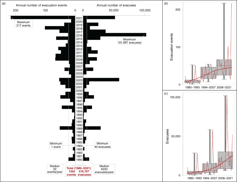
The number of wildland fire evacuees varies substantially from year to year; the fewest in 1984 with 40 evacuees, the most in 2016 with 101,997 evacuees, and an annual average of 13,732 evacuees and median of 6220 evacuees. Although 2021 had the most evacuation events, it had only the third highest number of wildland fire evacuees (51,742); this was exceeded in the years 2003 (58,395 evacuees) and 2016 (101,997 evacuees), which were both years where most evacuees were from a single evacuation event (the cities of Kelowna and Fort McMurray, respectively). Extreme years where larger urban population centres are affected can cause dramatic spikes in the number of evacuees. However, the average size of an evacuation is 423 people, and most (73%) evacuation events involve fewer than 300 evacuees. Overall, there have been 9 years with major evacuation events that attracted significant media attention and contributed to important peaks in evacuation events and evacuees (Table 1).
| Year | Number of evacuation events | Estimated number of evacuees | Primarily impacting Indigenous communities | Significant event | |
|---|---|---|---|---|---|
| 1989 | 52 | 28,632 | Y (38) | A total of 10,226 fires burned 3,567,947 ha in northern Manitoba, impacting many Indigenous communities. | |
| 2003 | 54 | 58,395 | N (9) | The Okanagan Mountain Park fire (Kelowna, BC) burned 239 houses and caused the evacuation of 27,000 residents. The McLure wildfire (Barriere and Louis Creek, BC) burned 72 houses and nine businesses in the Lower North Thompson Valley, including a sawmill which was the region’s largest employer. | |
| 2009 | 67 | 22,452 | N (17) | Numerous wildfires primarily in British Columbia and Alberta force the evacuation of multiple communities, including West Kelowna, BC. | |
| 2011 | 48 | 23,774 | Y (30) | The Flat Top complex wildfire burned one-third of the community of Slave Lake, Alberta, resulting in the evacuation of thousands of residents. | |
| 2015 | 64 | 28,079 | N (33) | Numerous fires across Northern Saskatchewan (including the Egg Fire) led to the evacuation of multiple communities. | |
| 2016 | 24 | 101,997 | Y (17) | The Horse River wildfire in the Regional Municipality of Wood Buffalo (including Fort McMurray, AB) caused the evacuation of the entire city and nearby communities. The fire destroyed 2400 houses and buildings. | |
| 2017 | 53 | 36,546 | N (17) | Numerous fires across the central and interior British Columbia impacted multiple communities for months. | |
| 2018 | 102 | 11,318 | N (39) | Numerous fires across the central and interior British Columbia impacted multiple communities for months. | |
| 2021 | 217 | 51,742 | N (75) | Numerous fires across multiple provinces. The most significant was the Lytton Creek wildfire, which destroyed most of the community of Lytton, BC and resulted in two fatalities. |
The annual number of evacuation events and evacuees is increasing over the 42 years of records in CWFED2021. There is a statistically significant monotonically increasing trend over the 1980–2021 period for evacuation events (Mann–Kendall: τ = 0.496, P < 0.0001; Fig. 1b) and for evacuees (τ = 0.445, P < 0.0001; Fig. 1c). The overall slope for events equates to an increase of one event per year (Sen slope = 1.0, P < 0.0001), and for evacuees an increase of 392 people per year (Sen slope = 392, P < 0.0001). Fig. 1b, c also shows box and whisker plots for annual values of three time periods: the most recent 14 years (2008–2021) represent years added to CWFED2021 since the first version of the CWFED was published (Beverly and Bothwell 2011), and the previous 28 years are split into equal time periods (1980–1993 and 1994–2007). The 2008–2021 period contains 59% of all evacuation events and 61% of all evacuees in the database. Though these trends are statistically significant, it is not possible to confidently attribute the increase to a real increase in the number of evacuations or evacuees over the years due to the data characteristics (e.g. increase in digital media reporting, improved record keeping; this is examined in the Discussion section).
Spatial patterns
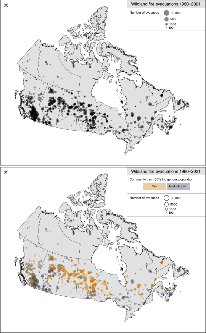
Spatial patterns of evacuation events and evacuees (Fig. 2a) indicate a widespread distribution across much of the country, although evacuation events vary substantially by province/territory in Canada (Fig. 3a). There is a particularly high density of evacuations in central British Columbia and many evacuations are found in a band of the boreal forest where people and flammable landscapes overlap more frequently. Between 1980 and 2021, British Columbia had the highest number of evacuation events with 528 (37.9%), followed by Alberta with 214 (15.4%), Ontario with 181 (13%), Manitoba with 159 (11.4%), Saskatchewan with 153 (11%), and Quebec with 65 (4.7%). The rest of the provinces and territories had less than 30 evacuation events each. Eighty-three percent of the evacuation events (438) in British Columbia occurred between 2008 and 2021.
Spatial location of wildfire evacuation events (points) and number of evacuees (point size) (1980–2021) for (a) evacuations recorded in the evacuation database, and (b) the same data but colour-coded by communities that have >50% Indigenous population (shown in orange) or communities that have either ≤50% Indigenous population or an unknown level of Indigenous population (shown in grey); darker shade indicates where there has been a higher density of evacuations.
Percent of evacuation events and evacuees in Canada (1980–2021) across spatially-delimited areas of (a) Canadian provinces and territories (Esri Canada 2022), (b) boreal, hemiboreal, and non-boreal forest areas (Brandt 2009), (c) categories of dense to sparse population density (AAFC-AAC and Agri-Geomatics 2016), (d) census subdivisions that range from less remote to more remote areas (Statistics Canada 2023), and (e) Fire Regime Types that characterise fire activity, seasonality, and ignition cause (Erni et al. 2020).
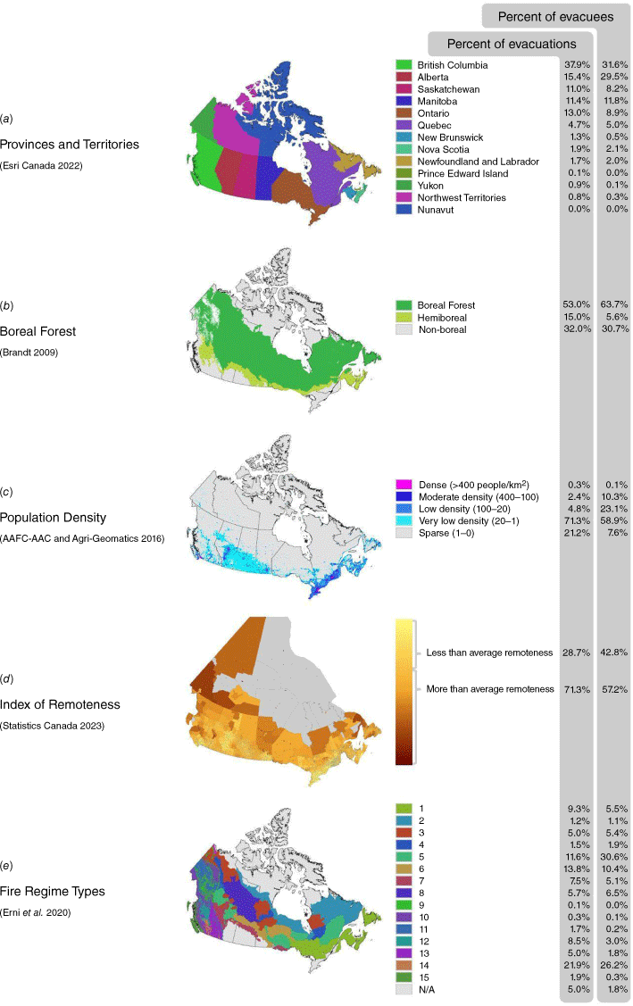
The number of wildland fire evacuees also showed significant regional variation (Fig. 3a). British Columbia had the highest with 182,241 evacuees (31.6%), followed by Alberta with 170,038 (29.5%), Manitoba with 67,941 (11.8%), Ontario with 51,406 (8.9%), Saskatchewan with 47,268 (8.2%), and Quebec with 28,642 (5%). The rest of the provinces and territories had 29,211 evacuees combined. Given the differences in provincial/territorial populations, it is also important to consider the total number of evacuees as a proportion of their respective populations. Using total populations from Statistics Canada’s 2021 census, Manitoba had the highest proportion of residents evacuated from wildland fire between 1980 and 2021 (5.1% of the population), followed by the Northwest Territories (4.4%), Saskatchewan (4.2%), Alberta (4.0%), British Columbia (3.6%), Newfoundland and Labrador (2.3%), and the Yukon (1.8%). The rest of the provinces and territories had less than 1% of residents evacuated by wildland fire.
Most of the evacuations and evacuees were from areas within the boreal forest zone, and some in the transitional hemiboreal subzone (Brandt 2009); only about one-third of evacuation events and evacuees occurred outside these biogeoclimatic areas (Fig. 3b). Most evacuations occurred in places with very low or sparse population densities (Fig. 3c). Similarly, most evacuees were from areas with very low population densities, though this is slightly more skewed due to the events where many people were evacuated from population centres. Most evacuations and evacuees were in census subdivisions considered remote (i.e. have higher than average ‘Index of Remoteness’), though this is more pronounced with number of evacuations than with number of evacuees (Fig. 3d).
Fire Regimes characterise distinct regional patterns of wildland fires, including fire activity, seasonality, and ignition cause (Erni et al. 2020). Approximately half of the evacuation events and two-thirds of the evacuees were from just three of Canada’s 15 Fire Regime Types (FRT; Fig. 3e): FRT 5, 6, and 14. FRT 5 and 6 are made up of multiple areas of the boreal forest. FRT 5 is characterised by low fire activity, mixed seasonality, and lightning-caused fires, while FRT 6 is characterised by moderate fire activity, mixed seasonality, and a mix of lightning- and human-caused fires. Finally, located in interior British Columbia, FRT 14 is characterised by low-moderate fire activity, summer fire season, and dominated by human-caused fires. Notably, FRT 14 has the smallest land area of all FRTs in Canada, yet it has the most evacuation events (21.9%) and the second highest number of evacuees (26.2%).
Timing (duration and season)
From 1980 to 2021, recorded wildland fire evacuations are often short, with 68.3% of events lasting less than a week (average duration 8.8 days, median duration 7.0 days). However, some evacuations are much longer, with some exceeding several months. The longest completed evacuation recorded in the database is the 2018 evacuation of Telegraph Creek, British Columbia at 102 days. The next longest is the 92-day evacuation of Pauingassi First Nation and Little Grand Rapids First Nation in 2021. However, some communities deal with the impacts of wildland fire evacuations long after the official order is closed and some remain evacuated at time of publication. There have been over 7.2 million days between 1980 and 2021 in which a person has been evacuated (i.e. ‘person days,’ where the duration of each evacuation is multiplied by the number of evacuees). Using Gray and Byford (2018) estimates of the cost of wildland fire evacuation, 7.2 million days of evacuation costs approximately CAD3.7 billion2. If we include estimates of household income loss, the cost is CAD4.6 billion3. The number of person days spent evacuated (and dollar value of associated costs plus lost income) is variable year to year. The most notable year is 2016 with over 2.5 million person days (CAD1.7 billion), and the annual average over the entire time period is 171,933 person days (CAD109 million).
Overall, 92% of events and 95% of evacuees were in May, June, July, and August (see centre section of Fig. 4), which is considered the main part of Canada’s fire season. Spring evacuations were typically shorter than those in late summer (Fig. 4), with April, May and June having an average duration of 6.7 days (median 6.0 days), while July, August, and September evacuations have an average of 10.5 days (median 7.0 days). Nationally, there were two wildland fire evacuation peaks: (1) of May (309 events); and (2) the summer months of July (413 events) and August (326 events). The only month that did not have an evacuation event recorded in the CWFED2021 is January. Evacuations in November, December, and February are generally caused by grass fires that spread in high winds.
Evacuation events 1980–2021 nationally and by province/territory, showing evacuation duration and their start and end dates throughout the year.
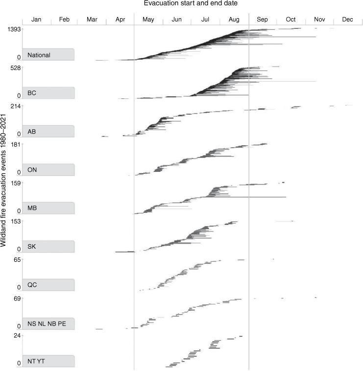
The timing and duration of evacuation events varied by province and territory (Fig. 4). Most events in British Columbia occurred in July and August (463 of 528). However, in neighbouring Alberta, most occurred in May (115 of 214). In contrast to other provinces and territories, Alberta also experienced evacuations in October, November, December, and February. In Saskatchewan, evacuations were more evenly distributed over the months of May, June, and July. Manitoba and Ontario evacuation events peaked in May and July, whereas Quebec and Newfoundland and Labrador experienced most evacuations in June. Like Alberta, New Brunswick evacuation events peaked in May. Nova Scotia had evacuations in June and August. The only wildland fire evacuation in Prince Edward Island occurred in May. The north-west Territories had evacuations in June, July, and August, and the Yukon experienced evacuations in June and July. British Columbia and Manitoba had longer duration evacuations compared with other provinces/territories.
Evacuation event duration in CWFED2021 increased in recent years. For the 28-year period from 1980 to 2007 (the years covered by the previous analysis in Beverly and Bothwell 2011), the average duration of all evacuation events was 5.6 days, but for the 14-year period from 2008 to 2021 the average duration was almost twice as long at 10.9 days (though median duration remained constant at 7.0 days). Recent years have seen more longer-duration events; for example, the maximum duration for an evacuation event in the database between 1980 and 2007 was 16 days, with a single event of that length. In contrast, from 2008 onward, there were 171 events (21% of all events in that period) with durations longer than 16 days. As with the temporal trends for evacuation events and number of evacuees, these trends should be considered carefully in the context of data limitations (see Discussion section).
Repeat evacuations
From 1980 to 2021, 211 communities evacuated more than once due to wildland fire (increased from 63 communities reported for 1980–2007 in Beverly and Bothwell (2011)). These communities are predominantly First Nations or other remote communities, primarily in north-western Ontario, northern Manitoba, and northern Saskatchewan, and more likely to be evacuated because of smoke rather than direct fire threat. Among these, 16 communities evacuated five or more times (Fig. 5), of which 14 were First Nations reserves and two were small towns or municipal districts. Only one of these communities (West Kelowna) has a population that identifies as primarily non-Indigenous (according to the Statistics Canada census; see Table 1). The remote Indigenous community of Webequie (ON) had the highest frequency of evacuations, at five times in just 5 years (with two evacuations occurring in a single year). In addition to the 16 communities evacuated five or more times, 21 communities were evacuated four times, 44 were evacuated three times, and 130 were evacuated twice in the last 42 years. Frequently, communities that are evacuated are very remote with limited access to community services and many lack year-round road access. These communities were also more likely to be evacuated due to smoke/health (54%) than direct threat (43%) compared to all other evacuations (17 and 78%, respectively).
Map showing density of point location of evacuations within each hexagonal cell (exact cell area is 3400 km2, which is ~1° × 1° at mid-latitudes of Canada) and location of communities that have experienced five or more evacuations due to wildfire from 1980 to 2021; for each community, the call-out boxes show the number of evacuations, location name, province/territory, community type (e.g. town, village, First Nation reserve), total number of evacuees across the repeated evacuations of that community, and average number of evacuees per evacuation.
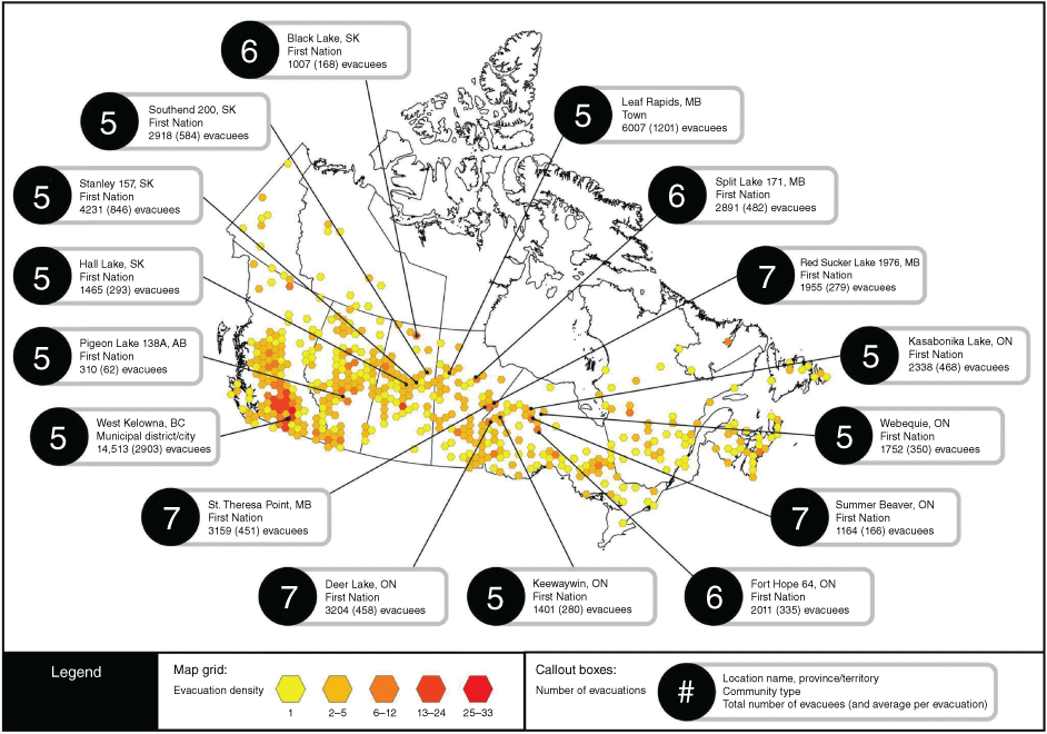
Evacuations are distributed across the country, but with high densities of evacuation events in some areas, most notably in British Columbia (Fig. 5). When looking at ‘populated places’ (Natural Resources Canada 2010) in Canada, 40% have had an evacuation within a 30-km radius. Populated places in British Columbia have experienced the highest density of proximal evacuation events, representing 35% of populated places that have had five or more evacuations within 30 km. This includes some centres with very high numbers of nearby evacuations, including Kelowna (20 events), Osoyoos (19), Lillooet (15), Vernon (13), Penticton (13), and Ashcroft (12).
Community type
Wildland fire evacuations in Canada occur in many different types of communities. To distinguish the most common community types that experience evacuation, each event was designated with 1 of 14 different ‘community types’ (Fig. 6). First Nations reserves were the most common type of community to experience wildland fire evacuation between 1980 and 2021, representing 34.6% (482) of evacuation events. The next most common was ‘geographic area’ (251), which indicates an evacuation order that is spread over a broad area and may include several populated areas but none with an official designation (e.g. town, village). Locality (population of <300) and town (population 1001–10,000) were next, with 248 and 130 evacuation events, respectively.
Number of evacuation events (bars) and number of evacuees (bar thickness) by community type (city, town, village, locality, First Nation reserve, geographical area, municipal district, and various ‘other’ categories of communities), with each category of community broken down by population representation being primarily Indigenous (bar colour).
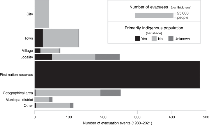
Although cities experienced only 42 wildland fire evacuation events, they had the most evacuees at approximately 159,000 from 1980 to 2021. Evacuees were primarily from three events: (1) Fort McMurray in 2016 (~88,000); (2) Kelowna in 2003 (~33,000); and (3) Williams Lake in 2017 (~11,000). First Nations had the next highest number of evacuees at ~158,000; this number represents many evacuation events with smaller numbers of evacuees per event. Towns were third highest with ~106,000 evacuees. Other documented community types included work camps (35 events/17,850 evacuees), campgrounds (54/7352), resorts (20/1331), Metis settlements (2/1113), and a single school (1/300). Unique entries include one Hutterite colony and one military base.
Cause and type of evacuation
In the CWFED2021, most wildland fire evacuations (1084/78%, 503,634 evacuees/87%) were caused by direct fire threat. British Columbia experienced the most wildland fire evacuations due to direct fire threat, followed by Alberta, and Ontario. The second leading cause of wildland fire evacuations was smoke (234/17%, 56,660 evacuees/10%). Smoke and health concerns caused the most evacuations in Manitoba, followed closely by Ontario and Saskatchewan. The third leading cause was other/unknown (75 events/5%, 16,453 evacuees/3%); this classification was primarily assigned to older events that lacked detailed documentation. Loss of access was the fourth most common cause, occurring in Alberta, British Columbia, Saskatchewan, Ontario, and Quebec.
The CWFED2021 records methods of evacuation for 1187 (85%) of wildland fire evacuation events, with 206 listed as unknown (14.7%). As shown in Fig. 7, most events were ground evacuations (71.9%). The next most common method of evacuation was air (10.5%). Of the 147 air evacuations recorded, 130 occurred in communities with >50% Indigenous population. Most non-Indigenous communities involved in air evacuations were either work camps or resorts (such as remote fishing camps). There were also evacuations by boat or rail, and some events involved a combination of transportation methods.
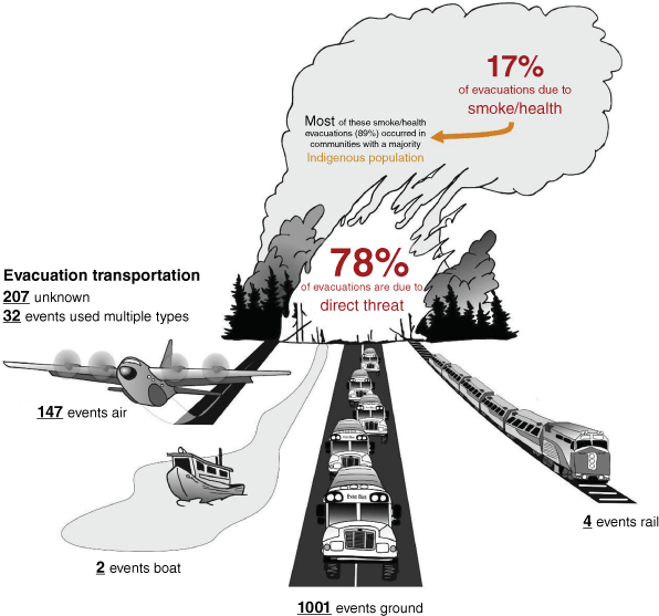
A total of 450,846 people evacuated by ground (78.2%), 61,464 by air (10.7%), and 25,885 by a combination (4.5%). Most air evacuations were caused by smoke (55.8%), while ground evacuations were typically caused by direct fire threat (85.6%). There were 857 ground evacuations due to direct fire threat (417,438 evacuees) and 98 due to smoke (21,429 evacuees). Air evacuations were conducted 82 times due to smoke (27,222 evacuees) and 64 times due to threat (33,998 evacuees). There were 30 combination evacuation events due to direct fire threat (24,522 evacuees) and eight due to smoke (1874). Ground evacuations lasted an average of 8.7 days while air evacuations were longer, lasting an average 10.9 days. The increased length of air evacuations is not surprising due to additional complexity coordinating air transportation.
Indigenous peoples
From 1980 to 2021, Indigenous communities in Canada were disproportionately affected by wildland fire evacuations. During this time, 41.9% of wildland fire evacuation events in Canada occurred in communities with predominately (i.e. >50%) Indigenous population (Fig. 2c). Additionally, Indigenous communities experienced more evacuation events than non-Indigenous communities in 13 of those years, despite making up a much smaller portion of the Canadian population. First Nations people living on reserve represented 27.5% (158,719 people) of wildland fire evacuees in 34.5% (481 events) of wildland fire evacuation events. As shown in earlier results, 14 of the 16 communities in Canada that experienced the most wildland fire evacuations were First Nations.
Indigenous communities were affected by evacuations caused solely by smoke. Of the 232 smoke evacuations recorded in the CWFED2021, 90% (208) were of communities with >50% Indigenous population. Smoke evacuations caused 35.7% (208) of wildland fire evacuation events experienced by Indigenous peoples, compared to only 3% (24) of the evacuations of non-Indigenous communities. Direct fire threat caused more evacuations of non-Indigenous communities (92%, 742) compared to Indigenous communities (60%, 350).
Loss of structures
In the CWFED2021, there were 130 evacuation events that involved the loss of homes (4105), 50 events with loss of seasonal/recreational residences (430), 86 events with loss of outbuildings (661) and 22 events with business structures lost (55). In total, there were 194 evacuations with structure loss (some events caused multiple categories of loss). Structure losses may have occurred in wildland fire events that did not have evacuations, but these events are not recorded in the CWFED2021.
Between 1980 and 2021, 31 years had wildland fire evacuation events with associated house losses. House losses coincided with 9.3% of evacuation events between 1980 and 2021. From 2008 on, every year had house losses recorded. Approximately 4105 houses have been lost, with 88% (3601) of those losses occurring since 2008. Several evacuations have been associated with significant structure loss. The Fort McMurray fire of 2016 caused 2574 house losses (63% of all homes lost in Canada from wildland fire) and 26 business structure losses. The 2011 Slave Lake evacuation event resulted in 300 houses destroyed and the 2003 Kelowna evacuation had 239 houses lost. The 2021 Lytton fire evacuation had an estimated 112 houses and business lost in Lytton, 34 houses on Klickkumchen IR 18, and five houses on Klahkamich IR 17 (Cohen and Westhaver 2022). Still, it is much more common for few houses to be lost to wildland fires associated with evacuations. In 76% (99) of evacuation events with associated losses, fewer than 10 houses were impacted. Most house losses (97% or 3999) occurred in western Canada (west of the Ontario border), with the majority in Alberta (73.4% or 3013).
Of the 430 seasonal/recreational structures that were reported lost during evacuation events, the majority were in Saskatchewan (45.8%), followed by Manitoba (20%). Of the 661 outbuildings destroyed, most were in British Columbia (53%) and Saskatchewan (25.9%). There were two evacuation events that resulted in substantial losses of seasonal structures and outbuildings. First, north-eastern Saskatchewan (2015) had 104 seasonal structures and 157 outbuildings reported as destroyed. Second, Louis Creek, British Columbia (2003) had 77 outbuildings destroyed (alongside 60 homes). In the Louis Creek fire, the local sawmill was also destroyed; this is represented as a single business structure loss in the database, however the loss had substantial impacts across the region. The database only reports 55 businesses lost in a wildland fire, with the majority in Alberta (49%).
Fatalities
Since 1980, there have been three civilian fatalities where death was directly caused by wildland fire. The first was in 1989 in the Lily Plain district of Saskatchewan, where a pulp contractor became entrapped by fire and later died from the resulting injuries (Beverly and Bothwell 2011; Koppang n.d.). In 2021, two deaths occurred in the community of Lytton, British Columbia, when residents were unable to escape the fire that ultimately destroyed most of the town. The evacuation database does not track fatalities that are indirectly caused by wildland fire and evacuations. Additionally, the database only records civilian fatalities, fire response and support staff fatalities are not included.
Discussion
This paper provides analysis of wildland fire evacuations in Canada between 1980 and 2021 based on the CWFED2021. In total, there have been 1393 evacuation events that resulted in over half a million evacuees over the 42 years in the database. The database only includes evacuations with available documentation, so it is likely that this is an underestimate with additional evacuations occurring without agency knowledge or media coverage.
We show that wildland fire evacuation events and evacuees increased over this time, with recent years having more evacuation activity. This trend in evacuation numbers may be influenced by a number of factors, including climate change effects on fire activity (e.g. more large fires, increased area burned, lengthened fire season (Wotton et al. 2017; Coops et al. 2018; Hanes et al. 2019; Kirchmeier-Young et al. 2018), increased fuel hazard around communities from fire exclusion in many parts of the country (Parisien et al. 2020), changes in land use and the number of people living at risk of fire (Johnston and Flannigan 2018; Johnston et al. 2020), and changes to fire management or evacuation policies, preferences, or risk tolerances (Wotton and Stocks 2006; McGee et al. 2014; CCFM (Canadian Council of Forest Ministers) 2016; Tymstra et al. 2020). Additionally, due to numerous limitations of the CWFED data, it is possible that the trend of increasing evacuations is impacted by the consistency in how evacuation events are determined, tracked, and reported by agencies and media across Canada. Media and public interest in wildland fire events significantly increased in recent years (Doerr and Santín 2016), particularly with the emergence of social media (Wang et al. 2016). A study by Sachdeva and McCaffrey (2022) analysing media print coverage between 1986 and 2016 in the USA, Canada, and Australia showed significantly more articles about wildland fires were published between 2005 and 2015 than the two decades prior. Such imbalanced coverage may influence apparent trends in this database. In addition, there is an operational trend to issue numerous separate evacuation orders instead of expanding existing orders in more recent years. This preference was predominantly seen across British Columbia and has the potential to significantly skew event representation. If an evacuation order is expanded, it is counted in the database as a single evacuation event. However, if a new order is issued, even if it neighbours an existing evacuation order, it counts as a separate evacuation event. This is an important consideration when comparing across years or jurisdictional boundaries.
Another notable limitation is that evacuation events may be missing details or entirely overlooked, particularly for small, remote, or historic evacuations. For example, there are no evacuations of Indigenous communities recorded for the years 1982 and 1984; while it is possible that this was the case, it is more likely events have been missed. Issues with evacuation event coverage are ongoing due to challenges with search indexing, especially across multiple languages.
Although evacuations are widespread across the country, a relatively low proportion of Canadians have been impacted by wildland fire evacuation events in the past 42 years and the average number of evacuees in each evacuation event is typically small. Despite these results, evacuations have very large impacts on the people involved. Wildland fires in Canada disproportionately impact those living in more remote areas with high fire activity (especially Indigenous peoples). Logistically complex air evacuations and evacuations of communities with limited road access are a challenge and a unique reality of many communities in Canada. Large population centres are rarely impacted (aside from wildland fire smoke) apart from the evacuations of Kelowna and Fort McMurray. Research shows that any type of evacuation can have significant mental health impacts, and that evacuees involved in smaller-size evacuations often feel they don’t receive the same post-evacuation supports that are provided for larger communities in more prominent evacuations (Christianson et al. 2019; McGee et al. 2021).
Another unique issue in Canada is that communities are evacuated solely due to the impacts of wildland fire smoke. Smoke evacuations sometimes start as precautionary partial evacuations due to potential impacts on vulnerable populations and then expand to more widespread evacuations as smoke impacts escalate or the potential for direct threat arises (Mottershead et al. 2020). There is also the risk of increased wildland fire smoke making an air evacuation impossible. Research with Indigenous Nations has led to the recommendation to establish community spaces where people can go to ‘escape’ wildland fire smoke (Treppel 2016; McGee et al. 2021). In some places, such as Northern Saskatchewan, agencies have begun to purchase air scrubbers to retrofit community buildings.
Information on which communities faced evacuations is particularly relevant to target evacuation management improvement, increase emergency management capacity, and invest in risk reduction activities that reduce the need for evacuation. Despite having thousands of fires and ~2 million ha of area burned in an average year in Canada (Hanes et al. 2019), only a few fires result in evacuation because much of the fire activity occurs in more northern, less populated areas of the country. Our analysis also points to important differences in when evacuations happen in certain provinces. The westernmost province in the country (British Columbia) had the most evacuation events in total (528) and these dominantly occurred in July and August; this is a shift from the earlier analysis by Beverly and Bothwell (2011) where Ontario had the most evacuations. In the province of Alberta, evacuations and structure loss occur more often in May. This seasonality difference has implications for emergency management, wildland fire response planning, and resource sharing between the two provinces.
Over two-thirds of evacuations were less than a week, but overall, the duration of evacuations appears to be increasing. In recent years, there have been significant extended evacuations, with some communities evacuated for months or still unable to return at the time of publication. One example is the Lytton Creek wildfire in 2021, where the community is yet to be rebuilt and many residents remain in temporary housing (Village of Lytton 2023). Although we provided an estimate of financial cost of evacuations based on evacuation duration, these estimates should not be considered precise or comprehensive. There are other unaccounted indirect costs and, as noted in a previous economic study (Gould et al. 2013), there is limited documentation of even the direct costs. Regardless of the total costs incurred, the financial toll of evacuations can be devastating for both evacuees and communities, given that many of the expenses incurred are not eligible for reimbursement (Scharbach and Waldram 2016; Christianson et al. 2019; McGee et al. 2021). In addition to the financial burden, longer duration evacuations have significant mental health impacts on evacuees (McGee et al. 2021).
Our research found that the disproportionate impact of wildland fire evacuations on Indigenous peoples continues and is increasing. In Beverly and Bothwell’s (2011) analysis of evacuations between 1980 and 2007, one-third of evacuations involved Indigenous communities. Our analysis of the most recent version of the database shows this has increased 41.9% during the period between 1980 and 2021. Given that only 5% of Canada’s population identifies as Indigenous, according to the 2021 census (Statistics Canada 2022), the frequency of Indigenous community evacuations is considerably higher than would be expected if impacts were proportional. Looking at only status First Nations peoples living on reserves,4 a similar over-representation is seen, with 158,719 evacuees from reserves equating to 37.4% of the total on-reserve population (425,652 people according to the 2021 census; Statistics Canada 2022).
Most communities that are repeatedly evacuated due to wildland fire are Indigenous and many of these communities also face frequent impacts from other natural hazards (e.g. floods) resulting in even more evacuations (Public Safety Canada 2023). Impacts on Indigenous Nations remain severe, with major issues regarding jurisdiction and other aspects of emergency management, including preparedness for evacuation events (Mihychuk 2018; McGee et al. 2021; Auditor General of Canada 2022). Again, the number of Indigenous people evacuated by wildland fires in the CWFED is likely significantly under-counted due to database limitations and because many communities impacted by wildland fire have large Indigenous populations but cannot be distinguished in the database. Census data for these communities is often unreliable. Therefore, evacuations relying on census numbers to estimate evacuees will typically undercount Indigenous peoples. The standards used to populate the CWFED were based on generalisations across Canada and may not be appropriate for Indigenous communities. For example, one standard is to estimate the evacuation of a household as three evacuees (Beverly and Bothwell 2011). This likely under-represents the number of Indigenous evacuees due to larger average household sizes and known housing issues on reserves and within Metis settlements. The CWFED also does not count urban Indigenous evacuees. For example, the city of Fort McMurray has a significant Indigenous population (although <50%), but those evacuees would not be included in the count of Indigenous evacuees. This specific oversight is modestly addressed with the addition of a field in the CWFED to flag communities with Indigenous populations >50%.
Approximately 5251 structures have been lost to wildfires during evacuation events between 1980 and 2021. However, incomplete recording of structure losses is another limitation of the database. The CWFED is missing many records of structural losses for smaller events, such as seasonal residences or outbuildings, as these losses may not be formally reported to agencies or documented in media. Though the structure loss data here are undoubtedly an underestimate, the CWFED is not intended for comprehensive structural loss tracking.
Our finding of only three direct fire fatalities in the four decades covered by the CWFED2021 is remarkable, given the experiences with wildland fire fatalities in other countries (Cruz et al. 2012; Lagouvardos et al. 2019; Filkov et al. 2020; Figueiredo et al. 2021). However, in the 1920s/1930s, there were multiple fatalities from wildland fire in Canada and there were multiple fatalities during a prescribed fire in 1979 in Esnagmi Lake, Ontario (Alexander 2010; Alexander and Buxton-Carr 2011). Research on injuries and death due to secondary or indirect impacts of fire (such as death or injury brought on by cardiac issues or respiratory problems related to wildfire smoke) is ongoing in Canada (e.g. Bowman and Johnston 2005; Matz et al. 2020; Aguilera et al. 2021; Holm et al. 2021), but further studies are needed.
The impacts of wildfire evacuations are already a significant issue in Canada and will become even more prominent with climate change and changes in population and land use. Because of the breadth of data collected in the CWFED, this article presents an initial analysis of some of the primary contents of the database. The database will continue to be updated annually, as there is increasing demand for information on evacuations and the impacts of wildfire in Canada. In addition, there is potential value in cross-referencing this data with other related sources. Further analyses could investigate evacuations in relation to fire activity and behaviour, climatic changes, weather conditions (building upon the work done by Tepley et al. (2022)), community emergency response capabilities, and socioeconomic impacts of evacuation. More data and knowledge of evacuations are a critical part of understanding the impacts of fire on people. This information is essential to improving evacuations and implementing locally suited and effective actions to reduce fire risk to people and their communities.
Data availability
The Canadian Wildland Fire Evacuation database contains sensitive information that cannot be shared publicly without a data agreement in place. Please contact Natural Resources Canada, Canadian Forest Service, Canadian Wildland Fire Information Systems group for more information cwfissa-csscifv@nrcan-rncan.gc.ca.
Acknowledgements
We thank past Canadian Forest Service staff who contributed to the Canadian Wildfire Evacuation Database, including Erin Naydenov and Sharon Romanowski. Thanks to Colin McFayden for assistance in developing Fig. 7. We acknowledge Robert W. Gray who assisted in determining an approximate cost of evacuations. We also thank the Assembly of First Nations, Prince Albert Grand Council, and Indigenous Services Canada for reviewing the database and providing additional information.
References
AAFC-AAC and Agri-Geomatics (2016) Population of Canada, 10 km Gridded. GIS vector. Available at https://open.canada.ca/data/en/dataset/c6c48391-fd2f-4d8a-93c8-eb74f58a859 [verified 14 March 2023]
Aguilera R, Corringham T, Gershunov A, Benmarhnia T (2021) Wildfire smoke impacts respiratory health more than fine particles from other sources: observational evidence from Southern California. Nature Communications 12, 8.
| Crossref | Google Scholar | PubMed |
Alexander M (2010) ‘Lest we forget’: Canada’s major wildland fire disasters of the past, 1825-1938. In ‘Proceedings of 3rd Fire Behavior and Fuels Conference’, 25–29 October 2010. (Eds D Wade, M Robinson) (Spokane, Washington, USA) Available at https://www.frames.gov/documents/catalog/alexander_2010_LestWeForgetCanadasMajorWildlandFireDisasters1825-1938.pdf [verified 22 December 2023]
Alexander M, Buxton-Carr P (2011) Wildland fire suppression related fatalities in Canada, 1941-2010: a preliminary report. In ‘Proceedings of 11th International Wildland Fire Safety Summit’, 4–8 April 2011. (Ed. IAWF) (Missoula, Montana, USA) Available at https://www.frames.gov/documents/catalog/alexander_and_buxton-carr_2011.pdf [verified 22 December 2023]
Asfaw HW, McGee TK, Christianson AC, Sandy Lake First Nation, (2019) Evacuation preparedness and the challenges of emergency evacuation in Indigenous communities in Canada: the case of Sandy Lake First Nation, Northern Ontario. International Journal of Disaster Risk Reduction 34, 55-63.
| Crossref | Google Scholar |
Asfaw HW, McGee TK, Christianson AC (2020) Indigenous elders’ experiences, vulnerabilities and coping during hazard evacuation: the case of the 2011 Sandy Lake First Nation wildfire evacuation. Society & Natural Resources 33, 1273-1291.
| Crossref | Google Scholar |
Auditor General of Canada (2022) Report 8 - Emergency Management in First Nations Communities - Indigenous Services Canada. Government of Canada, Office of the Auditor General, Cat. No. FA1-27/2022-1-8E-PDF. Available at https://www.oag-bvg.gc.ca/internet/docs/parl_oag_202211_08_e.pdf [verified 11 May 2023]
Betancur Vesga SM (2019) Inside the Rez Cross: An Assessment of Hosting Evacuees During a Wildfire Disaster in Beardy’s & Okemasis First Nation. Thesis, University of Saskatchewan, Canada. Available at https://harvest.usask.ca/bitstream/handle/10388/11913/BETANCURVESGA-THESIS-2019.pdf?sequence=1 [verified 11 May 2023]
Beverly JL, Bothwell P (2011) Wildfire evacuations in Canada 1980–2007. Natural Hazards 59, 571-596.
| Crossref | Google Scholar |
Boulianne S, Minaker J, Haney TJ (2018) Does compassion go viral? Social media, caring, and the Fort McMurray wildfire. Information, Communication & Society 21, 697-711.
| Crossref | Google Scholar |
Bowman DMJS, Johnston FH (2005) Wildfire smoke, fire management, and human health. EcoHealth 2, 76-80.
| Crossref | Google Scholar |
Bowman DM, Williamson GJ, Abatzoglou JT, Kolden CA, Cochrane MA, Smith AM (2017) Human exposure and sensitivity to globally extreme wildfire events. Nature Ecology & Evolution 1, 0058.
| Crossref | Google Scholar | PubMed |
Brandt JP (2009) The extent of the North American boreal zone. Environmental Reviews 17, 101-161.
| Crossref | Google Scholar |
CCFM (Canadian Council of Forest Ministers) (2016) Canadian Wildland Fire Strategy: A 10-year Review and Renewed Call to Action. (Canadian Council of Forest Ministers, Canadian Forest Service) Available at https://cfs.nrcan.gc.ca/pubwarehouse/pdfs/37108.pdf [accessed 11 June 2024]
Christianson AC, McGee TK, Whitefish Lake First Nation 459 (2019) Wildfire evacuation experiences of band members of Whitefish Lake First Nation 459, Alberta, Canada. Natural Hazards 98, 9-29.
| Crossref | Google Scholar |
Clark TD (2018) Rebuilding Resilient Communities in the RMWB: Final Report. (Willow Springs Strategic Solutions) Available at https://www.willowspringsss.com/case-studies/rebuilding-resilient-indigenous-communities [verified 11 May 2023]
Cleveland WS (1979) Robust locally weighted regression and smoothing scatterplots. Journal of the American Statistical Association 74, 829-836.
| Crossref | Google Scholar |
Cohen JD, Westhaver A (2022) An examination of the Lytton, British Columbia wildland-urban fire destruction: Summary Report to the British Columbia FireSmart Committee. (Institute for Catastrophic Loss Reduction) Available at https://firesmartbc.ca/wp-content/uploads/2022/05/An-examination-of-the-Lytton-BC-wildland-urban-fire-destruction.pdf [verified 11 May 2023]
Coops NC, Hermosilla T, Wulder MA, White JC, Bolton DK (2018) A thirty year, fine-scale, characterization of area burned in Canadian forests shows evidence of regionally increasing trends in the last decade. PLoS One 13, e0197218.
| Crossref | Google Scholar | PubMed |
Cote DW, McGee TK (2014) An exploration of residents’ intended wildfire evacuation responses in Mt. Lorne, Yukon, Canada. The Forestry Chronicle 90, 498-502.
| Crossref | Google Scholar |
Cruz MG, Sullivan AL, Gould JS, Sims NC, Bannister AJ, Hollis JJ, Hurley RJ (2012) Anatomy of a catastrophic wildfire: the Black Saturday Kilmore East fire in Victoria, Australia. Forest Ecology and Management 284, 269-285.
| Crossref | Google Scholar |
DeYoung SE, Chase J, Branco MP, Park B (2018) The effect of mass evacuation on infant feeding: the case of the 2016 Fort McMurray Wildfire. Maternal and Child Health Journal 22, 1826-1833.
| Crossref | Google Scholar | PubMed |
Dickson-Hoyle S, John C (2021) ‘Elephant Hill: Secwépemc leadership and lessons learned from the collective story of wildfire recovery.’ (Secwepemcu’l̓ecw Restoration and Stewardship Society) Available at https://www.srssociety.com/docs/elephant_hill_-_secw%C3% A9pemc_leadership_and_lessons_learned.pdf [verified 11 May 2023]
Doerr SH, Santín C (2016) Global trends in wildfire and its impacts: perceptions versus realities in a changing world. Philosophical Transactions of the Royal Society B: Biological Sciences 371, 20150345.
| Crossref | Google Scholar | PubMed |
Downe P, Scharbach J, Waldram JB (2018) Experiences of Disaster and “Maternal Risk” amidst Forest Fire Evacuation in Northern Saskatchewan. Journal of Mother Studies 3, Available at https://jourms.org/experiences-of-disaster-and-maternal-risk-amidst-forest-fire-evacuation-in-northern-saskatchewan/ [verified 11 May 2023].
| Google Scholar |
Drolet JL, Lewin B, Pinches A (2021) Social Work Practitioners and Human Service Professionals in the 2016 Alberta (Canada) wildfires: roles and contributions. The British Journal of Social Work 51, 1663-1679.
| Crossref | Google Scholar |
Erni S, Wang X, Taylor S, Boulanger Y, Swystun T, Flannigan MD, Parisien M (2020) Developing a two-level fire regime zonation system for Canada. Canadian Journal of Forest Research 50, 259-273.
| Crossref | Google Scholar |
Erni S, Johnston L, Boulanger Y, Manka F, Bernier P, Eddy B, Christianson A, Swystun T, Gauthier S (2021) Exposure of the Canadian wildland–human interface and population to wildland fire, under current and future climate conditions. Canadian Journal of Forest Research 51, 1357-1367.
| Crossref | Google Scholar |
Esri Canada (2022) ‘Provinces and Territories of Canada. GIS layer.’ (Esri Canada - Technology Strategy Group) Available at https://hub.arcgis.com/datasets/d3fef65386df4e63b02d6e23bb98a1ee_0/about [verified 11 May 2023]
Figueiredo R, Paupério E, Romão X (2021) Understanding the Impacts of the October 2017 Portugal Wildfires on Cultural Heritage. Heritage 4, 2580-2598.
| Crossref | Google Scholar |
Filkov AI, Ngo T, Matthews S, Telfer S, Penman TD (2020) Impact of Australia’s catastrophic 2019/20 bushfire season on communities and environment. Retrospective analysis and current trends. Journal of Safety Science and Resilience 1, 44-56.
| Crossref | Google Scholar |
Flannigan MD, Logan KA, Amiro BD, Skinner WR, Stocks BJ (2005) Future area burned in Canada. Climatic Change 72, 1-16.
| Crossref | Google Scholar |
Folk LH (2019) The Use of Human Behaviour in Fire to Inform Canadian Wildland Urban Interface Evacuations. Thesis, York University, Canada. Available at https://yorkspace.library.yorku.ca/xmlui/handle/10315/36336 [verified 22 November 2023]
Gaur A, Bénichou N, Armstrong M, Hill F (2021) Potential future changes in wildfire weather and behavior around 11 Canadian cities. Urban Climate 35, 100735.
| Crossref | Google Scholar |
Gould JS, Patriquin MN, Wang S, McFarlane BL, Wotton BM (2013) Economic evaluation of research to improve the Canadian forest fire danger rating system. Forestry 86, 317-329.
| Crossref | Google Scholar |
Hanes C, Wang X, Jain P, Parisien M-A, Little J, Flannigan M (2019) Fire regime changes in Canada over the last half century. Canadian Journal of Forest Research 49, 256-269.
| Crossref | Google Scholar |
Holm SM, Miller MD, Balmes JR (2021) Health effects of wildfire smoke in children and public health tools: a narrative review. Journal of Exposure Science & Environmental Epidemiology 31, 1-20.
| Crossref | Google Scholar | PubMed |
Ingalsbee T (2017) Whither the paradigm shift? Large wildland fires and the wildfire paradox offer opportunities for a new paradigm of ecological fire management. International Journal of Wildland Fire 26, 557-561.
| Crossref | Google Scholar |
Johnston LM, Flannigan MD (2018) Mapping Canadian wildland fire interface areas. International Journal of Wildland Fire 27, 1-14.
| Crossref | Google Scholar |
Johnston LM, Wang X, Erni S, Taylor SW, McFayden CB, Oliver JA, Stockdale C, Christianson A, Boulanger Y, Gauthier S, Arseneault D, Wotton BM, Parisien M-A, Flannigan MD (2020) Wildland fire risk research in Canada. Environmental Reviews 28, 164-186.
| Crossref | Google Scholar |
Kirchmeier-Young MC, Gillet NP, Zwiers FW, Cannon AJ, Anslow FS (2018) Attribution of the Influence of Human-Induced Climate Change on an Extreme Fire Season. Earth's Future 7(1), 2-10.
| Crossref | Google Scholar |
Kolden CA (2020) Wildfires: count lives and homes, not hectares burnt. Nature 586, 9.
| Crossref | Google Scholar | PubMed |
Koppang E (n.d.) Elwood Koppang: 1980 - 1989 In Two Towers. Available at https://www.websiteservice.ca/documentdocs/elwoodstory.pdf [verified 11May 2023]
Kulig JC, Townshend I, Botey AP, Shepard B (2018) “Hope is in Our Hands:” Impacts of the Slave Lake Wildfires in Alberta, Canada on Children. In ‘Assisting Young Children Caught in Disasters’. (Ed. J Szente) pp. 143–156. (Springer: Cham, Switzerland) 10.1007/978-3-319-62887-5_14
Lagouvardos K, Kotroni V, Giannaros TM, Dafis S (2019) Meteorological conditions conducive to the rapid spread of the deadly wildfire in Eastern Attica, Greece. Bulletin of the American Meteorological Society 100, 2137-2145.
| Crossref | Google Scholar |
Lalani N, Drolet JL, McDonald-Harker C, Brown MRG, Brett-MacLean P, Agyapong VIO, Greenshaw AJ, Silverstone PH (2021) Nurturing spiritual resilience to promote post-disaster community recovery: the 2016 Alberta Wildfire in Canada. Frontiers in Public Health 9, 682558.
| Crossref | Google Scholar | PubMed |
Mamuji AA, Rozdilsky JL (2019) Canada’s 2016 Fort McMurray wildfire evacuation: experiences of the Muslim community. International Journal of Emergency Management 15, 125-146.
| Crossref | Google Scholar |
Mann HB (1945) Non-parametric tests against trend. Econometrica 13, 245-259.
| Crossref | Google Scholar |
Matz CJ, Egyed M, Xi G, Racine J, Pavlovic R, Rittmaster R, Henderson SB, Stieb DM (2020) Health impact analysis of PM2.5 from wildfire smoke in Canada (2013–2015, 2017–2018). Science of The Total Environment 725, 138506.
| Crossref | Google Scholar | PubMed |
McGee TK (2019) Preparedness and experiences of evacuees from the 2016 Fort McMurray Horse River Wildfire. Fire 2, 13.
| Crossref | Google Scholar |
McGee T, McFarlane B, Tymstra C (2014) Wildfire: A Canadian Perspective. In ‘Wildfire Hazards Risks Disasters’. (Eds D Paton, PT Buergelt, S McCaffrey, F Tedim, JF Shroder) pp. 35–58. (Elsevier: Amsterdam) 10.1016/B978-0-12-410434-1.00003-8
McGee TK, Nation MO, Christianson AC (2019) Residents’ wildfire evacuation actions in Mishkeegogamang Ojibway Nation, Ontario, Canada. International Journal of Disaster Risk Reduction 33, 266-274.
| Crossref | Google Scholar |
McGee TK, Christianson AC, Partnership FNWE (2021) ‘First Nations Wildfire Evacuations: A Guide for Communities and External Agencies.’ (University of British Columbia Press) Available at https://press.uchicago.edu/ucp/books/book/distributed/F/bo86430890.html
Mihychuk M (2018) From the Ashes: Reimagining Fire Safety and Emergency Management in Indigenous Communities. Report of the Standing Committee on Indigenous and Northern Affairs. Available at https://www.ourcommons.ca/Content/Committee/421/INAN/Reports/RP9990811/inanrp15/inanrp15-e.pdf [verified 11 May 2023]
Montesanti S, Fitzpatrick K, Azimi T, McGee T, Fayant B, Albert L (2021) Exploring Indigenous ways of coping after a wildfire disaster in Northern Alberta, Canada. Qualitative Health Research 31, 1472-1485.
| Crossref | Google Scholar | PubMed |
Mottershead KD, McGee TK, Christianson A (2020) Evacuating a First Nation due to wildfire smoke: the case of Dene Tha’ First Nation. International Journal of Disaster Risk Science 11, 274-286.
| Crossref | Google Scholar |
Natural Resources Canada (2010) North American Atlas – Populated Places. Dataset. NRC Government of Canada, Mapping Information Branch, The Atlas of Canada. Available at https://ftp.maps.canada.ca/pub/nrcan_rncan/vector/framework_cadre/North_America_Atlas10M/popplaces/ [verified 11 May 2023]
Parisien M-A, Barber QE, Hirsch KG, Stockdale CA, Erni S, Wang X, Arseneault D, Parks SA (2020) Fire deficit increases wildfire risk for many communities in the Canadian boreal forest. Nature Communications 11, 2121.
| Crossref | Google Scholar | PubMed |
Public Safety Canada (2023) The Canadian Disaster Database. Available at https://www.publicsafety.gc.ca/cnt/rsrcs/cndn-dsstr-dtbs/index-en.aspx [accessed 21 November 2023]
Pujadas Botey A, Kulig JC (2014) Family functioning following wildfires: recovering from the 2011 Slave Lake Fires. Journal of Child and Family Studies 23, 1471-1483.
| Crossref | Google Scholar |
Sachdeva S, McCaffrey S (2022) Themes and patterns in print media coverage of wildfires in the USA, Canada and Australia: 1986–2016. International Journal of Wildland Fire 31, 1089-1102.
| Crossref | Google Scholar |
Scharbach J, Waldram JB (2016) Asking for a disaster: being “At Risk” in the emergency evacuation of a Northern Canadian Aboriginal Community. Human Organization 75, 59-70.
| Crossref | Google Scholar |
Seto KC, Fragkias M, Güneralp B, Reilly MK (2011) A meta-analysis of global urban land expansion. PLoS One 6, e23777.
| Crossref | Google Scholar | PubMed |
Sharp K, Krebs A (2019) Trial By Fire: Nadleh Whut’en and the Shovel Lake Fire, 2018. Nadleh Whut’en First Nation. Available at http://www.resonantstrategic.ca/wp-content/uploads/2018/12/Trial-By-Fire.pdf [verified 11 May 2023]
Shepard B, Kulig J, Botey AP (2017) Counselling children after wildfires: a school-based approach. Canadian Journal of Counselling and Psychotherapy 51, 61-80 Available at https://cjc-rcc.ucalgary.ca/article/view/61097 [verified 11 May 2023].
| Google Scholar |
Statistics Canada (2022) The Daily — Indigenous population continues to grow and is much younger than the non-Indigenous population, although the pace of growth has slowed. Available at https://www150.statcan.gc.ca/n1/daily-quotidien/220921/dq220921a-eng.htm [verified 11 May 2023]
Statistics Canada (2023) Index of Remoteness. Dataset. Available at https://www150.statcan.gc.ca/n1/pub/17-26-0001/172600012020001-eng.htm [verified 11 May 2023]
Stocks BJ, Mason JA, Todd JB, Bosch EM, Wotton BM, Amiro BD, Flannigan MD, Hirsch KG, Logan KA, Martell DL, Skinner WR (2002) Large forest fires in Canada, 1959–1997. Journal of Geophysical Research: Atmospheres 107, FFR 5-1-FFR 5-12.
| Crossref | Google Scholar |
Taylor S, Stennes B, Wang S, Taudin-Chabot P (2006) Integrating Canadian wildland fire management policy and institutions: Sustaining natural resources, communities and ecosystems. In ‘Canadian wildland fire strategy: Background syntheses, analyses, and perspectives’. (Eds K Hirsch, P Fuglem) pp. 3–25. (Canadian Council of Forest Ministers)
Tedim F, Leone V, Amraoui M, Bouillon C, Coughlan MR, Delogu GM, Fernandes PM, Ferreira C, McCaffrey S, McGee TK, Parente J, Paton D, Pereira MG, Ribeiro LM, Viegas DX, Xanthopoulos G (2018) Defining Extreme Wildfire Events: Difficulties, Challenges, and Impacts. Fire 1, 9.
| Crossref | Google Scholar |
Tepley AJ, Parisien M-A, Wang X, Oliver JA, Flannigan MD (2022) Wildfire evacuation patterns and syndromes across Canada’s forested regions. Ecosphere 13, e4255.
| Crossref | Google Scholar |
Tymstra C, Stocks BJ, Cai X, Flannigan MD (2020) Wildfire management in Canada: review, challenges and opportunities. Progress in Disaster Science 5, 100045.
| Crossref | Google Scholar |
Verhaeghe C, Feltes E, Stacey J (2018) NAGWEDIẐK’AN GWANEŜ GANGU CH’INIDẐED GANEXWILAGH: The Fires Awakened Us: Tsilhqot’in Report on the 2017 Wildfires. (Tsilhqot’in National Government) Available at https://www.tsilhqotin.ca/wp-content/uploads/2020/12/the-fires-awakened-us.pdf [verified 11 May 2023]
Village of Lytton (2023) Recovery. Available at https://lytton.ca/recovery/ [verified 21 November 2023]
Wahlqvist J, Ronchi E, Gwynne SM, Kinateder M, Rein G, Mitchell H, Bénichou N, Ma C, Kimball A, Kuligowski E (2021) The simulation of wildland-urban interface fire evacuation: The WUI-NITY platform. Safety Science 136, 105145.
| Crossref | Google Scholar |
Wang X, Thompson DK, Marshall GA, Tymstra C, Carr R, Flannigan MD (2015) Increasing frequency of extreme fire weather in Canada with climate change. Climatic Change 130, 573-586.
| Crossref | Google Scholar |
Wang Z, Ye X, Tsou M-H (2016) Spatial, temporal, and content analysis of Twitter for wildfire hazards. Natural Hazards 83, 523-540.
| Crossref | Google Scholar |
Woo M, Hui KTY, Ren K, Gan KE, Kim A (2017) Reconstructing an Emergency Evacuation by Ground and Air the wildfire in Fort McMurray, Alberta, Canada. Transportation Research Record 2604, 63-70.
| Crossref | Google Scholar |
Wotton BM, Stocks BJ (2006) Fire management in Canada: vulnerability and risk trends. In ‘Canadian Wildland Fire Strategy: Background Synthesis, Analysis, and Perspectives’. (Eds K Hirsch, P Fuglem) pp. 49–55. (Canadian Council of Forest Ministers. Natural Resources Canada, Canadian Forest Service, Northern Forestry Centre: Edmonton, AB)
Wotton BM, Flannigan MD, Marshall GA (2017) Potential climate change impacts on fire intensity and wildfire suppression thresholds in Canada. Environmental Research Letters 12, 095003.
| Crossref | Google Scholar |
Yerushalmi A, Folk L, Carton H, Gales J, Khan A, Weckman B (2022) Fire evacuation modelling of a Canadian wildland urban interface community. Canadian Journal of Civil Engineering 49, 31-40.
| Crossref | Google Scholar |
Yumagulova L, Phibbs S, Kenney CM, Yellow Old Woman-Munro D, Christianson AC, McGee TK, Whitehair R (2019) The role of disaster volunteering in Indigenous communities. Environmental Hazards 20, 45-62.
| Crossref | Google Scholar |
Footnotes
1 Note that this database is not publicly accessible, as it contains intergovernmental information that is classified as sensitive, including evacuee number and detailed notes on each evacuation from government agencies.
2 From Gray and Byford (2018), $5,838,216 is the cost of the first day of evacuation, $1,674,088 for each additional day. $5,838,216 + 7.8 × $1,674,088 = $18,896 102/10,400 in the city of Cranbrook = $1816.93/household for an 8.8 day evacuation. If we assume the average household is 2.5 people, the evacuation cost for a Cranbrook evacuee would be 2.5 × $1816.93 = $4542.33 for an 8.8-day evacuation, or approximately $516.17/day/evacuee.
3 From Gray and Byford (2018), productivity loss for Cranbrook is based on average daily income per household of $241.17 ($88,027 is the new Cranbrook average annual household income/10,400 households). If we assume there are two working people in each household, the productivity loss is approximately $120.59 per person per day. Combined productivity loss plus evacuation cost = $516.17 + $120.59 = $636.76/day/evacuee.
4 40.6% of First Nations’ peoples live on reserve (Statistics Canada 2022).