

Pre-fire assessment of post-fire debris-flow hazards in the Santa Fe Municipal Watershed
Manuel Lopez A * , Ellis Margolis B , Anne Tillery C , Steve Bassett D and Alan Hook E
A
B
C
D
E
Abstract
Wildfires are increasing in size and severity due to climate change combined with overstocked forests. Fire increases the likelihood of debris flows, posing significant threats to life, property, and water supplies.
We conducted a debris-flow hazard assessment of the Santa Fe Municipal Watershed (SFMW) to answer two questions: (1) where are debris flows most likely to occur; and (2) how much debris might they produce? We also document the influence of fuel treatments on fire severity and debris flows.
We modelled post-fire debris-flow likelihood and volume in 103 sub-basins for 2-year, 5-year, and Probable Maximum Precipitation rainfalls following modelled low-, moderate-, and high-severity wildfires.
Post-fire debris-flow likelihoods were >90% in all but the lowest fire and rain scenarios. Sub-basins with fuel treatments had the lowest burn severities, debris-flow likelihoods, and sediment volumes, but treatment effects decreased with increased fire severity and rain intensity.
Post-fire debris flows with varying debris volumes are likely to occur following wildfire in the SFMW, but fuel treatments can reduce likelihood and volume.
Future post-fire debris flows will continue to threaten water supplies, but fuel reduction treatments and debris-flow mitigation provide opportunities to minimise effects.
Keywords: debris-flow model, fire modelling, FlamMap, forest treatments, fuel treatments, New Mexico, post-fire hazards.
Introduction
Fire size and severity are increasing across the south-western United States (Singleton et al. 2019), driven by climate change (Abatzoglou and Williams 2016; Mueller et al. 2020) and increased vegetation and fuel loads (Covington and Moore 1994; Hagmann et al. 2021). Fire was historically common in many south-western forests (Swetnam and Baisan 1996), but fire exclusion for more than a century has increased tree densities and fuel loads (Allen et al. 2002). This change in forest structure has presented forest managers with a multitude of challenges related to increasingly severe fires, including post-fire forest loss (Guiterman et al. 2018; Coop et al. 2020) and effects on water resources, such as increased flooding, decreased water quality, and post-fire debris flows (Tillery et al. 2022; Williams et al. 2022). The south-west is forecasted to have longer periods of hot and dry weather followed by increased summer Monsoon rain intensity (IPCC 2012), which sets up ideal conditions for post-fire debris flows.
Severe wildfires alter vegetation and soils, increasing the susceptibility of burned watersheds to erosion and debris flows (Cannon and Gartner 2005). High- and moderate-severity fires disrupt infiltration by decreasing vegetation cover, understorey litter, forest canopy, as well as changing soil properties to become less porous (Meyer 2002; Bodí et al. 2014). Debris flows in recently burned areas typically initiate as overland flows that progressively entrain and transport soils and rock as they increase in flow and coalesce into rills and channels (Cannon et al. 2003). Once channelled, the powerful, sediment-laden flows can then lead to channel bed failure, generating sediment concentrations high enough to move as a debris flow (Cannon 2001; Cannon et al. 2003; Kean et al. 2013). These runoff-generated debris flows are typically initiated by short-duration, high-intensity rainfall that occurs commonly during the summer monsoon. Post-fire debris flows can initiate quickly (<15 min) following moderate intensity rainfall, irrespective of antecedent moisture conditions (Kean and Staley 2011; Kean et al. 2011; Schmidt et al. 2011; Staley et al. 2013). While some danger of erosion, flooding, or debris flow also exists in unburned watersheds, burned areas produce these phenomena with much greater frequency and magnitude (Cannon and DeGraff 2009; McGuire et al. 2021).
Watershed managers face multiple threats to surface water supplies that are amplified by climate change. In addition to the threats of fire and post-fire debris flows, surface water supplies in the arid south-western US are also declining due to climate change (e.g. Dunbar et al. 2022). Management options include fuel reduction treatments, such as thinning and prescribed fire, which are intended to reduce fire severity and restore ecosystem structure and function (Hessburg et al. 2021). These treatments may also have the added benefit of lowering post-fire debris-flow hazard through the reduction of fire severity, yet the connection between fuel treatments and post-fire debris flows has rarely been assessed or quantified. Pre-fire modelling of post-fire debris-flow hazards that incorporates the influences of pre-fire management actions provides opportunities to assess the reduction of post-fire effects with pre-fire actions.
The goal of this research was to model post-fire debris-flow likelihood and volume for multiple fire and rain scenarios in the Santa Fe Municipal Watershed (SFMW), which generates a significant portion of the water supply for the state capital (Santa Fe) of New Mexico, Santa Fe. We address two fundamental questions in this debris-flow hazard assessment: (1) where are debris flows most likely to occur? and (2) how much debris might they produce? We also document observations on the influence of fuel reduction treatments on burn severity and post-fire debris flows in the study area. The results will provide water and forest/fire managers information that can be used in pre-fire mitigation planning and post-fire response.
Materials and methods
Study area
The Santa Fe Municipal Watershed (SFMW) is located in the Santa Fe National Forest east of the City of Santa Fe in the Sangre de Cristo Mountains of northern New Mexico (Fig. 1). The SFMW typically provides one-third of the annual water supply for over 80,000 people residing within the City of Santa Fe and Santa Fe County. The SFMW comprises 70 km2 in the uppermost reaches of the Santa Fe River Basin that drains to the Rio Grande.
The headwaters of the Santa Fe River in north-central New Mexico, including the Santa Fe Municipal Watershed (SFMW). Mapped fuel reduction treatments include areas burned with prescribed fire since 2008. Locations of paired treated and untreated sub-basins referenced in the text are denoted by T and U, repectively.
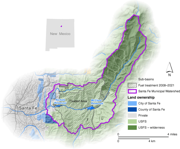
Within the SFMW, there are two reservoirs: (1) McClure is the furthest upstream in the watershed and has a capacity of 4.02 million m3; and (2) Nichols is below McClure and has a smaller capacity of 843,000 m3 (Jorgenson and Puglisi 2018a, 2018b). All sub-basins with pour points entering the Santa Fe River upstream of McClure Reservoir, or directly into the reservoir, were used for volumetric calculations affecting McClure (i.e. ‘upstream’ of Mclure). Sub-basins with pour points entering the Santa Fe River below McClure Reservoir or directly into Nichols Reservoir were used for volumetric calculations affecting Nichols (i.e. ‘upstream’ of Nichols).
The upper elevations of the SFMW lie within the Pecos Wilderness and are dominated by mixed conifer and spruce-fir forest. Lower elevation forests are ponderosa pine and piñon-juniper woodlands on a mix of National Forest, local government, and privately protected lands (Chiocchio 2013). Annual average precipitation ranges from 1041 mm at the uppermost elevations to 457 mm at the lower elevations (PRISM Climate Group 2014). The SFMW receives winter precipitation as snow and summer Monsoon precipitation as high-intensity, short-duration afternoon thunderstorms from July to September, immediately following the peak fire season (April–June).
Hazardous fuel reduction treatments to reduce wildfire severity and to protect the surface water supply have been conducted in the lower SFMW, outside of the Wilderness area (Fig. 1). Treatments have been ongoing since 2003 and include thinning small diameter trees, mastication of woody fuel, piling of thinned fuel, and prescribed fire. Two types of prescribed fire have been conducted in the SFMW: (1) pile burns where cut fuel is piled and burned when there is snow on the ground; and (2) broadcast burns where the fire is ignited to spread within a predetermined area. Fuel reduction treatments in the SFMW are partially funded through a novel payment for ecosystem services agreement (Bennett et al. 2014).
Modelling fire severity
Pre-fire assessments of post-fire debris flows require some estimate of burn severity, as post-fire debris flows are a function of burn severity among other variables. Previous assessments of post-fire debris-flow hazards prior to wildfire have used a variety of methods to estimate burn severity such as simulated crown fire potential (Tillery et al. 2014) or statistical analyses of historical distributions of fire severity (Staley et al. 2018). However, previous studies have not attempted to quantify the effect of fuel treatments on post-fire debris-flow hazards.
In this study, crown fire potential was modelled using FlamMap (Finney 2006), after the Tillery et al. (2014) method. The FlamMap model was parameterised with a digital representation of the fuel and topography of the study area from LANDFIRE ver. 2.1.0 (Ryan and Opperman 2013). The fuel layers reflect changed vegetation and reduce fuel in areas where mechanical and fire treatments were applied. Wind and live and dead fuel moisture data inputs to the fire model were from the SFMW remote automated weather station (RAWS; Horel et al. 2002). Weather data were processed in FireFamily Plus v5 (Bradshaw and McCormick 2000) for the period 2008 to 2020 (Table 1).
| Parameter | 75th Pctl | 90th Pctl | 97th Pctl | |
|---|---|---|---|---|
| Fuelscape (.lcp) | LANDFIRE ver. 2.1.0 | LANDFIRE ver. 2.1.0 | LANDFIRE ver. 2.1.0 | |
| Wind direction (°) | 282 | 282 | 282 | |
| 6 m wind speed (kph) A | 14.5 | 17.7 | 41.8 | |
| Fuel moisture (%) B | ||||
| 1-h | 7 | 5 | 4 | |
| 10-h | 9 | 8 | 6 | |
| 100-h | 11 | 9 | 8 | |
| Herbaceous | 105 | 30 | 30 | |
| Woody | 125 | 60 | 60 | |
| Foliar | 120 | 110 | 90 | |
To capture a range of possible future burn severities in the SFMW, we used three weather scenarios as inputs into FlamMap. Weather records from the Santa Fe RAWS were used to generate fire-weather probabilities. For a low fire intensity scenario, we used 75th percentile weather conditions; for the moderate fire intensity scenario, we used 90th percentile weather conditions; and for a near-worst-case fire intensity scenario we used 97th percentile weather conditions. Based on conversations with local fire management officers we made two adjustments to the inputs to better capture recent observed fire behaviour. First, we used wind gust speed, which is higher than the default average wind speed, for the 97th percentile scenario, to better match observed local severe fire behaviour under extreme weather scenarios. Second, live herbaceous and live woody fuel moistures were increased from 100 to 105%, and 120 to 125%, respectively for the 75th percentile conditions to better match observed lower severity fire effects under those weather conditions.
The debris-flow model has two fire severity inputs for each sub-basin: (1) soil burn severity class (i.e. low, moderate, and high burn severity), which is used to determine the proportion of the sub-basin burned at high or moderate severity; and (2) average differenced Normalised Burn Ratio (dNBR), a satellite-derived value of post-fire vegetation change (Key and Benson 2006). Fire-severity classes were derived by converting the modelled low, moderate, and high crown fire index from FlamMap to low, moderate, and high burn severity. We acknowledge that high-severity fire can occur without crown fire, or that independent crown fire could have limited influence on soils. However, recent fire behaviour in the region suggests that crown fire is common in severely burned areas that produce debris flows, which supports the ‘crosswalk’ between crown fire index and fire severity. Average dNBRs for the modelled fire-severity classes for each sub-basin were derived from the distribution of dNBR values from areas in the nearby 2011 Pacheco Fire classified as low, moderate, and high burn severities (MTBS Data Access: Fire Level Geospatial Data 2017). This fire burned an adjacent watershed with a similar elevation range and similar vegetation as the SFMW.
Modelling post-fire debris-flow likelihood, volume, and combined hazard
We modelled debris-flow hazard under three fire-weather scenarios and three rainfall scenarios with permutations of these variables producing nine unique scenarios representing a range of combined events. The scenarios range from a fire burning under relatively low intensity fire weather followed by a relatively common 2-year recurrence interval rainfall event, to a fire burning under near-worst-case fire weather followed by a near-worst-case rainfall event. Post-fire debris-flow likelihood and volume, and a combined debris-flow hazard score, were modelled for each of the nine scenarios. To quantify the hazard of post-fire debris flow in the SFMW, the best available models of post-fire debris-flow likelihood (Staley et al. 2016, Eqn 1 and expected debris-flow volume (Gartner et al. 2014, Eqn 2, were combined to estimate relative, conditional post-fire debris-flow hazard.
where P is the statistical likelihood of debris-flow occurrence in fractional form, e is Eulers number, and
x is the link function of the Generalised Linear Model, with:
where PropHM23 is the proportion of upslope area burned at high or moderate severity with topographic slope greater than or equal to 23°, d15 is the 15-min rainfall accumulation in millimetres, KFFACT is the soil erodibility index of the fine fraction of soils, and dNBR is the average dNBR of the upslope area. The volume model equation is then applied:
where V is the debris-flow volume, including water, sediment, and debris (m3), Relief is upslope relief, in metres, HMkm is the drainage-basin area burned at moderate to high severity in km2, and i15 = 15-min rainfall intensity, in mm/h.
The 15-min rainfall intensities used for this study were selected to represent a range of storm occurrence probabilities. The storms included: (1) a 2-year recurrence rain event (50% annual occurrence probability); (2) a 5-year recurrence event (20% annual occurrence probability); and (3) the probable maximum precipitation (PMP) expected. The 2- and 5-year recurrence events were from the National Oceanic and Atmospheric Administration (NOAA) Precipitation-Frequency Atlas of the western US (Miller et al. 1973; Bonnin et al. 2006). The data were extracted from the NOAA Atlas 14 grid, resampled to 30-m using bilinear interpolation and averaged per sub-basin to capture the varied rainfall intensities expected across the topographic relief in the SFMW. The PMP values were extracted from Atlas 14 data that incorporates historical events (Colorado–New Mexico Regional Extreme Precipitation Study 2018). The PMP was applied as a consistent value for every sub-basin.
A 30-m spatial resolution DEM from the USGS 3D Elevation Program (3DEP) (Sugarbaker et al. 2014) was used to map slopes greater than or equal to 23° for development of the PropHM23 parameter (Eqn 1) and to produce the upslope relief parameter (see Eqn 2). Erodibility of fine soil components (Kf-factor) (Römkens et al. 1997) is based on soil texture and was extracted for the study area from a 100-m gridded soils properties dataset that includes SSURGO (Soil Survey Staff 2023) polygons (Ramcharan et al. 2018). Debris-flow likelihood and volume were modelled for 103 sub-basins delineated within the SFMW (Fig. 1). Sub-basins were generated with TauDEM (Tarboton 2019) with pour points delineated where first order tributaries (Strahler 1957) flow into the main channel of the Santa Fe River, and also for primary tributaries that are most susceptible to transmitting debris into McClure or Nichols Reservoirs. Sub-basins range in size from 0.03 to 7.9 km2.
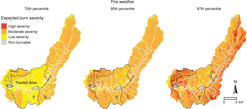
Expected burn severity modelled with FlamMap using 75th, 90th, and 97th percentile fire weather scenarios to represent the range of fire intensities and resulting burn severities expected in the Santa Fe Municipal Watershed. Treated sub-basins outlined in black were broadcast burned between 2008 and 2021. ‘T’ and ‘U’ indicate paired treated and untreated sub-basins used for comparison.
The likelihood of debris-flow occurrence following wildfire for any burned sub-basin was modelled using a logistic curve generalised linear model (GLM) developed to predict post-fire debris-flow likelihood in the western US (Staley et al. 2016). Likelihoods predicted by the model can range from 0 (least likely) to 1 (most likely). Example model input parameters for paired, treated and untreated sub-basins are included in Table 2. These example, paired treated (T) and untreated (U) sub-basins were selected for comparison throughout the paper because they are adjacent basins with similar geology, soils, northerly aspects, forest types, and basin area (see Fig. 1 for paired basin locations). Although these basins were similar in many respects the untreated basin had greater relief.
| PropHM23 | d15 (mm/h) | Mean dNBR | ||||||||||
|---|---|---|---|---|---|---|---|---|---|---|---|---|
| Sub-basin | 75th | 90th | 97th | 2-year | 5-year | PMP | 75th | 90th | 97th | KFFACT | ||
| Treated (T) A | 0.03 | 0.54 | 0.58 | 51.4 | 68.5 | 132.7 | 138.6 | 310.9 | 389.4 | 0.32 | ||
| Untreated (U) | 0.59 | 0.74 | 0.79 | 52.0 | 69.0 | 132.7 | 278.8 | 331.8 | 506.1 | 0.30 | ||
PropHM23, proportion of the sub-basin burned at High and Moderate severity with slopes greater than 23°; d15, 15-min rainfall accumulation in mm; mean dNBR, average of the differenced normalised burn ratio in the sub-basin; KFFACT, soil erodibility index of the fine fraction of soils. Model outputs for these sample sub-basins are in Table 3.
| Debris-flow likelihood | ||||||||||
|---|---|---|---|---|---|---|---|---|---|---|
| 75th percentile fire weather | 90th percentile fire weather | 97th percentile fire weather | ||||||||
| Sub-basin | 2 years | 5 years | PMP | 2 years | 5 years | PMP | 2 years | 5 years | PMP | |
| Treated (T) | 0.65 | 0.88 | 1.00 | 0.99 | 0.99 | 1.00 | 0.99 | 1.00 | 1.00 | |
| Untreated (U) | 0.99 | 0.99 | 1.00 | 0.99 | 1.00 | 1.00 | 1.00 | 1.00 | 1.00 | |
The treated sub-basin was thinned and broadcast burned.
Debris volume is a function of relief, area burned at high or moderate severity, and the peak 15-min rainfall intensity. Debris volume model input parameters are included in Table 4. The debris-flow volume model was validated by Gartner et al. (2014) based on a variety of comparisons including 95 percentile prediction interval, order of magnitude comparisons, and volumes of sediment within 1000, 5000, 10,000, 50,000, 100,000, and 500,000 m3. To be consistent with these limitations of model accuracy, we report modelled volumes to two significant figures (e.g. 2300 m3, or 110,000 m3).
| i15 (mm) | HMkm | |||||||
|---|---|---|---|---|---|---|---|---|
| Sub-basin | Relief (m) | 2-year | 5-year | PMP | 75th | 90th | 97th | |
| Treated (T) A | 382.6 | 12.85 | 17.13 | 33.18 | 0.06 | 1.34 | 1.5 | |
| Untreated (U) | 808 | 13 | 17.25 | 33.18 | 1.1 | 1.3 | 1.43 | |
Relief, upslope relief in metres; i15, 15-min rainfall intensity, in mm/h; HMkm, drainage-basin area burned at high to moderate severity in km2 for low- (70th percentile), moderate- (90th percentile), and high-intensity (97th percentile) fire scenarios. Model outputs for these sample sub-basins are in Table 5.
| Sub-basin | McClure | Nichols | SFMW | ||
|---|---|---|---|---|---|
| Min (m3) | 0 | 820,000 (20%) | 82,000 (10%) | 980,000 | |
| Max (m3) | 690,000 | 4,800,000 (119%) | 980,000 (116%) | 6,100,000 |
The minimum volume is associated with the 75th percentile fire-weather/2-year rain scenario and the maximum is associated with the 97th percentile fire-weather/PMP rain scenario. Volumes for debris entering Nichols only include sub-basins below McClure. Percent of total capacity is included for the two reservoirs.
To facilitate interpretation of results, debris-flow likelihoods were grouped into five ranks and debris-flow volumes were grouped into four ranks with the largest numbers representing the highest hazards (either likelihood or volume; Cannon et al. 2010). Ranks from debris-flow likelihood and volume were added to produce combined debris-flow hazard values (1–9, with 9 representing the most hazardous). The most hazardous sub-basins include a combination of high likelihood of debris-flow occurrence and large modelled volume of eroded material.
Results
Modelled burn severity
Thinning and burning treatments in the SFMW influenced the modelled fire severity through reduced fuel. The fuel treatments reduced modelled fire severity in all fire weather scenarios, but it was most evident in the low fire-weather intensity scenario (Fig. 2). For the 75th fire-weather percentile scenario, 47% of the watershed was modelled to burn at low severity and 52% at moderate severity. Distinct changes from low to moderate severity fire occurred across treatment boundaries. For example, the modelled mean burn severity in one treated sub-basin was less than half of that in a nearby, similar untreated sub-basin for the low-severity fire scenario (Table 2). The treated sub-basin had lower fire severity across all fire scenarios, although the differences diminished with increased fire weather. The 90th percentile fire-weather scenario simulation produced 14% low-severity, 84% moderate-severity, and 2% high-severity fire. The locations of low-severity fire were primarily within treated areas. The 97th percentile, or near-worst-case fire-weather simulation produced 9% low-severity, 69% moderate-severity, and 22% high-severity fire. In this fire-weather scenario, the high-severity patches were primarily on the untreated, north-facing (wetter and denser) slopes in the upper watershed, along with a large patch in untreated lower elevation forest north of Nichols reservoir (Fig. 2).
Modelled post-fire debris-flow likelihood
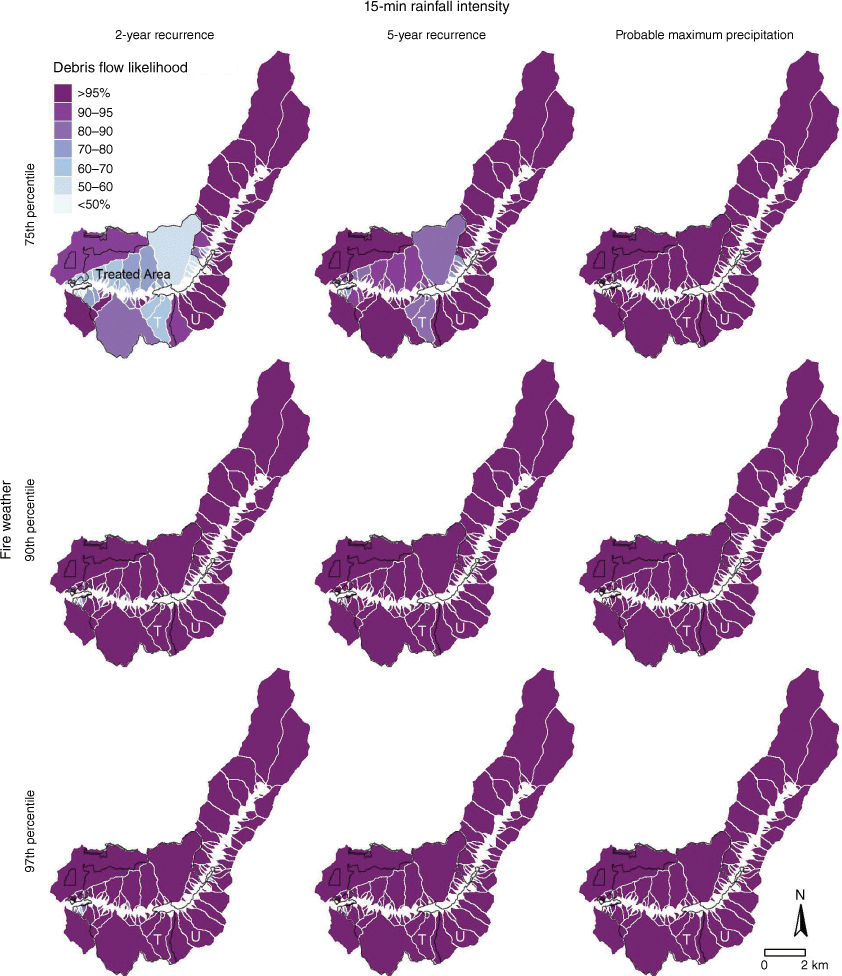
The lowest and most variable post-fire debris-flow likelihoods were associated with the 75th percentile fire scenario and 2-year rain event (Fig. 3). Outside of this scenario, post-fire debris-flow likelihoods for most sub-basins increase to >90% throughout the SFMW. For the 75th percentile fire/low rain scenario, sub-basins north and downstream of McClure reservoir had the lowest debris-flow likelihoods (48–97%). The areas with the lowest debris-flow likelihoods were all within treated areas (Fig. 3). Some sub-basins upstream of McClure Reservoir had substantially higher debris-flow likelihoods (70–100%), even under the 75th percentile weather scenario and low rain intensity. These include untreated, steep, densely forested, sub-basins immediately south and east of the reservoir, as well as others within the Pecos wilderness (Fig. 3). Debris-flow likelihoods increased in each sub-basin with an increase in rainfall. All sub-basins reached 91–100% likelihood of post-fire debris-flow occurrence with the PMP storm, and during 90th and 97th percentile fire-weather/rain scenarios.
Modelled post-fire debris-flow likelihoods for individual sub-basins in the Santa Fe Municipal Watershed for multiple fire and 15-min rainfall intensities. The vertical axis indicates fires modelled using 75th, 90th, and 97th percentile fire weather. The horizontal axis represents rain scenarios at 2-year recurrence interval (52 mm/h), 5-year recurrence interval (69 mm/h), and the probable maximum precipitation (132 mm/h). ‘T’ and ‘U’ indicate paired treated and untreated sub-basins used for comparison.
Modelled post-fire debris-flow volume
The modelled post-fire debris-flow volume ranged from 0 to 690,000 m3 among sub-basins across the three rain and fire scenarios (Fig. 4, Table 5). A maximum modelled volume of 4,800,000 and 980,000 m3 could enter McClure and Nichols, respectively. This would be 119% of the capacity of McClure Reservoir and 116% of capacity for Nichols. The total volume of sediment mobilised by post-fire debris flows in the SFMW ranged from 980,000 to 6,100,000 m3. In contrast to likelihood, sub-basin size is positively associated with debris-flow volume. The sub-basin north of McClure reservoir (area = 5.4 km2), which the model indicated has some of the lowest likelihoods for debris-flow due to fuel treatments, also had lower estimated volumes, ranging from 4700 m3 for the 75th percentile fire-weather scenario combined with the 2-year storm, up to 180,000 m3 for the 97th percentile fire-weather scenario combined with the PMP storm.
Modelled post-fire debris-flow volumes per sub-basin for 2 years, 5 years, and PMP rain scenarios and low-, moderate-, and high-severity fires. See Fig. 3 caption for fire and rain scenario details.
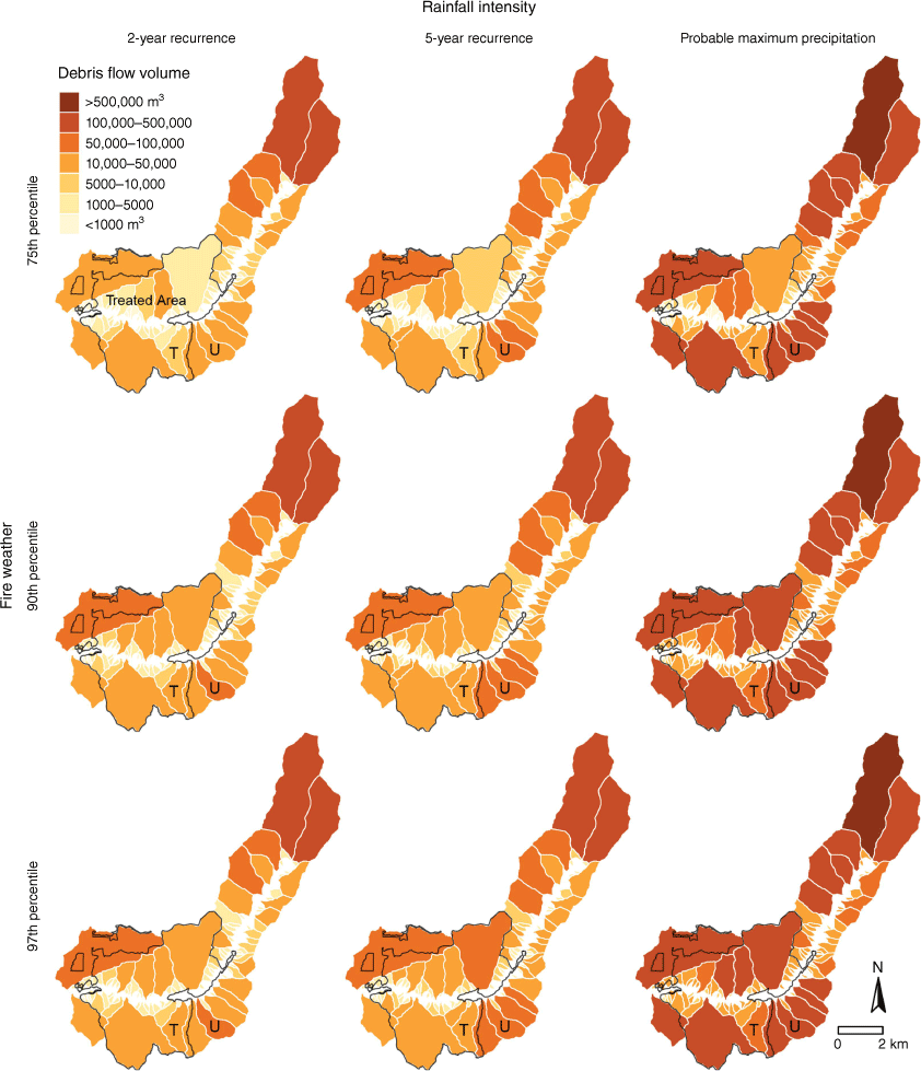
Depending on the location and size of a precipitation event, the main channel of the Santa Fe River could receive debris from many of the sub-basin tributaries simultaneously. Between the headwaters of the Santa Fe River and McClure Reservoir there are more than 20 sub-basins representing potential volumes greater than 10,000 m3 from a 2-year and 5-year recurrence interval storms and more than 10 sub-basins with potential volumes greater than 100,000 m3 in the PMP scenario. The combined debris-flow sediment entering the Santa Fe River upstream from the McClure Reservoir could reach volumes greater than 100,000 m3 depending on fire location, fire severity, and storm intensity and size. Nichols Reservoir could also be impacted with debris-flow volumes entering the Santa Fe River upstream of the reservoir greater than 10,000 m3 in surrounding sub-basins during 2-year and 5-year recurrence interval storms and greater than 100,000 m3 for the PMP storm. The differences in volume as shown in Fig. 4 are subtle but increases occur upstream in every tributary given an increase in storm intensity.
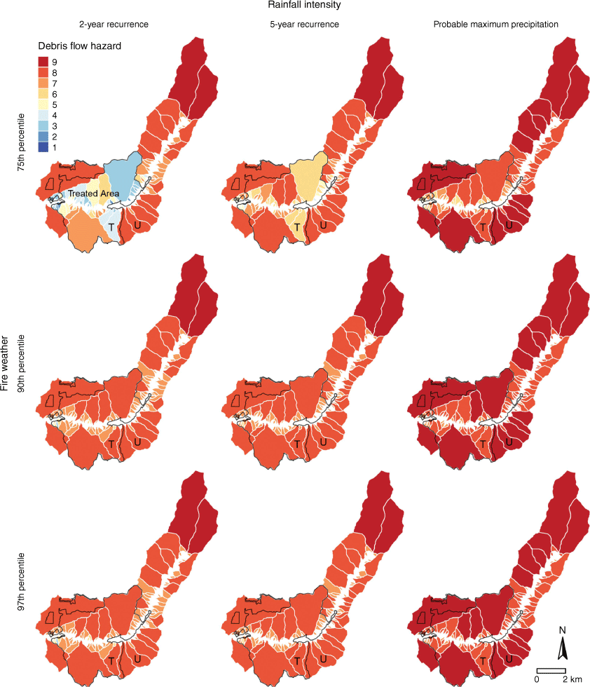
Modelled combined post-fire debris-flow hazard
Combined post-fire debris-flow hazard varies among sub-basins, for different combinations of fire and rain scenarios, and treatment status (Fig. 5). The number of sub-basins with a high (8–9) combined hazard index increased from 11.3% for the 2-year recurrence interval storm to over 54% for the 5-year storm recurrence. As sub-basin size has a direct correlation to volumetric output, some sub-basins with high debris-flow likelihood but lower volumetric output, show only a moderate combined hazard. Most of the sub-basins with moderate hazard have undergone fuel treatments, especially in the larger sub-basins around and downstream of McClure Reservoir (Figs 1 and 5). The two large, untreated sub-basins at the headwaters of the SFMW have a high hazard regardless of rain or fire scenarios. Post-fire debris-flow models with multiple burn severity scenarios and commonly recurring storms predict that the majority of SFMW sub-basins are at risk of high hazard events.
Combined post-fire debris flow hazard for three fire-weather percentile and rain scenarios for all sub-basins in the Santa Fe Municipal Watershed. Hazard is calculated from the combined indices of debris flow probability and volume. See Fig. 3 caption for fire and rain scenario details.
Discussion
Post-fire debris-flow likelihood
The fire and debris-flow models indicate a high likelihood of post-fire debris flows throughout much of the SFMW, across a range of fire and rainfall scenarios, including following a common rain event. Only under the low severity fire/low-intensity rain scenario was variability in debris-flow likelihood among sub-basins obvious, with some relatively large sub-basins north of McClure having less than 60% likelihood of debris flows (Fig. 3). These lower debris-flow likelihoods occurred in areas that had mechanical fuel reduction treatments followed by prescribed fire, highlighting the potential added benefit beyond fire hazard reduction, although we did not explicitly quantify the relative influence of reduced fire severity versus other variables, such as slope. Debris-flow likelihoods increased following a moderate or near-worst-case fire and are likely to occur in all sub-basins, for all simulated rain scenarios. These results support prior research that indicates the increasing susceptibility of these steep forested watersheds to post-fire debris flows, which have been commonly observed following fires in the region and in New Mexico, such as the 2000 Cerro Grande fire in the Jemez Mountains, NM (Cannon and Reneau 2000), the 2012 Whitewater-Baldy fire in the Gila Wilderness, NM (Tillery and Rengers 2020), the 2018 Buzzard Fire in southern NM (McGuire and Youberg 2020), and the 2022 Hermit’s Peak/Calf Canyon Fire in northern NM.
Debris-flow volume
There was greater variability in modelled post-fire debris-flow volume than likelihood, largely due to the variability and influence of sub-basin size, slope, and fire severity. The influence of fuel treatments to reduce debris-flow volume, through reduced fire severity, is evident in multiple sub-basins (Fig. 4). This is particularly evident in the large sub-basin north of McClure Reservoir that has been repeatedly burned with prescribed fire and has lower modelled debris-flow volume than adjacent, smaller untreated sub-basins. It is important to note that slope (or relief) has a strong influence on modelled debris volumes (see Eqn 2, Gartner et al. 2014), and we did not explicitly quantify the relative influence of relief versus reduced fire severity in the lower modelled volumes of untreated areas (e.g. the paired treated and untreated basins). We did conduct a sensitivity analysis by attributing the fire severity of the untreated paired basin to that of the lower fire severity observed in the treated basin, and there was a reduction in modelled debris volume for the untreated basin.
Although there have been many treatments to reduce fuel around and below the largest reservoir (McClure), most of the sub-basins upstream of McClure have not been treated, and these forests have been accumulating fuel since the last fire over 140 years ago (Margolis and Balmat 2009). The resulting debris-flow likelihoods and potential debris-flow volumes are therefore high in those sub-basins, even following a low-severity fire. The maximum modelled debris-flow volume mobilised upstream of McClure Reservoir is 119% of the reservoir storage (4,800,000 m3). Less extreme scenarios (e.g. moderate fire-weather severity and a 5-year rain event) could generate 1,500,000 m3 of debris, and should that debris travel as far as the reservoir, could possibly cover the McClure Reservoir emergency release valves (Jorgenson and Puglisi 2018a). The maximum modelled debris-flow volume mobilised upstream of Nichols Reservoir (980,000 m3) is 116% of the reservoir storage. Less extreme scenarios (e.g. moderate fire-weather severity and a 2-year rain event) could generate 82,000 m3 of debris, or 10% of the total storage capacity in Nichols Reservoir, which could cover operational and emergency release valves (Jorgenson and Puglisi 2018b). Nichols Reservoir is the source of the diversion to the water treatment plant that directly provides water for Santa Fe.
Part of the study area is downstream of the reservoirs (Fig. 1), so that potential debris volume (31,000–240,000 m3 for the low and high fire-weather plus rainfall events) would enter the channel below the reservoirs and could affect downstream infrastructure including road crossings, trails, acequias (small irrigation channels), and homes. The basin created by a former reservoir downstream of the study area could be useful to receive debris generated below the main reservoirs.
It is important to note that the modelled debris volumes reported are for a single rain event. If multiple, substantial rainfall events occur in 1 year or in successive years, then the cumulative volumes could be greater than we report. Cumulative debris volumes over multiple years could be greater than our single-event modelled results. Repeated debris flows have occurred following recent fires in the region, including in Santa Clara Canyon, New Mexico, where debris flows continued to occur >10 years following a large, severe fire. Alternatively, recent post-fire debris flow volumes in Arizona were less than those predicted by the debris-flow model (e.g. Gorr et al. 2023). This could indicate the potential for overpredicted debris volumes for areas outside of where the model was calibrated in California (Gartner et al. 2014).
Influences of fuel treatments on future post-fire debris flows
Post-fire debris-flow hazard is lower in treated sub-basins compared to similar untreated sub-basins, largely due to decreased fuel loads from treatments, which decreases modelled burn severity and consequently lowers debris-flow hazard (Figs. 2, 3 and 5; Tables 3, 5, 6). The effectiveness of treatments at reducing burn severity in dry conifer forests has been well documented (e.g. Lydersen et al. 2014) and observed locally, when the 2020 En Medio wildfire was stopped at a recent prescribed fire. More work to include post-fire debris-flow hazard in empirical treatment effectiveness studies would be helpful in evaluating and identifying pre-fire mitigation opportunities.
| Volume (m3) | ||||||||||
|---|---|---|---|---|---|---|---|---|---|---|
| 75th percentile fire weather | 90th percentile fire weather | 97th percentile fire weather | ||||||||
| 2 years | 5 years | PMP | 2 years | 5 years | PMP | 2 years | 5 years | PMP | ||
| Treated (T) | 5 200 | 8 000 | 28,000 | 16,000 | 24,000 | 86,000 | 16,000 | 25,000 | 90,000 | |
| Untreated (U) | 47,000 | 73,000 | 250,000 | 51,000 | 78,000 | 270,000 | 52,000 | 80,000 | 280,000 | |
The treated sub-basin was thinned and broadcast burned.
Although post-fire debris-flow hazard is generally high under moderate and extreme rainfall intensities even in treated areas, the reductions in hazards for areas that have been treated are still evident (Fig. 5). Planning for both likely and unlikely post-fire rainfall intensities will produce a robust mitigation environment. In future studies, the likelihood of rainfall occurrence in the critical few years following a fire could be used to scale the hazard proportionately to the likelihood of that event happening (e.g. the 2-year return interval storm is 2.5 times more likely than the 5-year storm so should be weighted as such). We also think our combined fire severity and debris-flow modelling approach opens opportunities for assessing potential fuel treatment influences on fire severity and post-fire debris flows, which could include simulations with multiple fuel treatment scenarios, or untreated versus treated fire severity and post-fire debris-flow scenarios that aren’t possible without models.
Model limitations
The combined debris-flow volume model output assumes that the entire SFMW burns during a fire. If only a portion of the SFMW burns, the model results should be considered for only the burned portion. The total area of the watershed is 7000 ha. Single-day, high-severity fire runs of 5000–15,000 ha are increasingly common in regional wildfires. The 2022 Hermit’s Peak/Calf Canyon Fire in northern New Mexico burned more than 130,000 ha, so it is likely that a single fire could burn a large proportion, or the entirety of the watershed, particularly during increasingly warm, dry, and windy conditions.
There are additional assumptions related to the spatial scale of rainfall events. Sub-basin debris-flow volume outputs assume a rainfall event covers the entire sub-basin, and outputs for the full watershed assume a watershed-wide rainfall event. Most summer monsoon rainfall events would not likely cover the entire SFMW, as these types of storms tend to be very localised, yet there is precedent in the region for widespread rain events, often associated with tropical storms, causing widespread post-fire debris flows (e.g. September 2013 in New Mexico and Colorado; Coe et al. 2014; Tillery and Rengers 2020).
The model is not valid for a no-fire scenario. While debris flows, flooding, erosion, and mass wasting events are possible in unburned watersheds (Tillery and Rengers 2020), these events cannot be predicted with this model. The model also does not establish debris-flow runout distances or predict eventual depositional location of mobilised sediment. Sediment that is mobilised in a debris flow will typically be deposited in a debris fan where there is an abrupt decrease in slope, such as where a sub-basin intersects with a main channel. Following initial mobilisation and deposition, freshly deposited sediment may continue to migrate further down the main channels with each subsequent storm for several years. Finally, recent post-fire debris flow observations from Arizona suggest that the model may overestimate debris volume (e.g. Gorr et al. 2023). Additional validations of modelled debris volumes outside of California, where the model was developed, are important to understand model accuracy and uncertainty.
Even though there are model limitations and uncertainties, regional increases in fire size and severity and observations and forecasts for increased intensity of rain events with climate change, suggest that post-fire debris flows are increasingly likely in the SFMW and could impact multiple high-value components of the watershed and water supply.
Management implications
Given the effects of fuel treatments to reduce burn severity and consequently reduce post-fire debris-flow likelihoods and volume, management priorities in the SFMW could be placed on treatments in sub-basins that have high modelled debris-flow volume and hazard upstream of the larger reservoir (McClure). Additional untreated areas upstream and downstream of the smaller reservoir (Nichols) that have high debris-flow hazard could also be prioritised for treatments. There are plans for possible prescribed fire treatments in the dry conifer forests in the wilderness, which is located upstream of McClure reservoir, during very specific seasonal windows (e.g. when south aspects are snow-free, but surrounding areas have snow). These treatments would reduce fuel and create heterogeneity in an area that is otherwise difficult to manage and poses high, post-fire debris-flow hazard. Recent, nearby fires and the high-risk sub-basins identified in this analysis point to increasing urgency for application of mitigation measures. Increasing temperatures driving increased fire risk and longer burn seasons require new fire management approaches, particularly in high-value areas.
The reservoirs are a high priority for water supply and flood risk, but other values at risk from post-fire debris flows might include infrastructure associated with the reservoirs, the water delivery and treatment system, roads, and wildlife habitat both within and downstream of the SFMW. The road providing access to the reservoirs and the pipe that carries water from the reservoirs to the treatment plant could be susceptible to damage from erosion or debris traveling down the main channel after being ejected from side channels. Even a small debris flow could make the road impassable and severely limit post-fire mitigation efforts upstream. Sub-basins downstream of the reservoirs also pose potential risk to roads, trails, and infrastructure, as well as being a source of sediment to the main channel near the water-treatment plant. Treatment prioritisation can be aided by a cost-benefit analysis of treatments. Several steep sub-basins south of McClure Reservoir (Fig. 3), have high likelihoods of post-fire debris flows even with the low fire-severity scenario combined with a 2-year recurrence interval rainfall event. Debris generated in these sub-basins would be deposited either directly in McClure reservoir or within 1 km upstream of the reservoir, resulting in minimal time to respond or options for relocating sediment. Some sub-basins that are small may not yield much benefit with treatment, while other sub-basins that are particularly large, remote, and/or steep may be infeasible to treat.
Conclusions
Post-fire debris flows are a substantial, increasing hazard in the SFMW and other similar forested watersheds across the western US The spatially explicit estimates of post-fire debris-flow likelihood, volume, and combined hazard for individual sub-basins from this analysis can assist in developing priorities and mitigation plans prior to and following wildfire. Pre-fire and post-fire hazard mitigation and planning can be implemented through actions that include, but are not limited to, fuel reduction treatments, check dams in sub-basins, hydro-mulching, cross-felling of dead trees, early warning systems, and dredging. Efficacy of mitigation efforts can be site-specific and pre-fire planning is crucial for maximum mitigation efficiency following a wildfire. Example post-fire mitigation planning documents and experiences from municipal watersheds that have dealt with post-fire debris flows (e.g. Los Alamos County, New Mexico; Santa Clara Pueblo, New Mexico; Las Vegas, New Mexico; and Boulder, Colorado) can also be sources of information and can serve as templates. It is also important to consider additional, post-fire watershed changes not addressed in this study, including decreased water quality (e.g. increased ash, changes in nutrients and carbon, or metal mobilisation) in planning for post-fire responses (Rhoades et al. 2019).
Data availability
The data that support this study are are publicly available at USGS Sciencebase.gov (https://doi.org/10.5066/P99VO9E1).
Declaration of funding
This study was funded by the City of Santa Fe. Additional funding provided by the USGS Ecosystems Mission Area Climate Research and Development Program for analysis and writing. Steve Bassett’s contribution to modelling, analysis, and manuscript preparation was funded by the Rio Grande Water Fund.
Acknowledgements
J. Roach from the City of Santa Fe commented on earlier drafts. E. Kasten assisted in compiling fuel treatment data. J. Kostelnik (USGS) provided valuable data input and advice. R. Sack and S. Hurlocker from the Santa Fe National Forest provided insight and guidance on fire modelling accuracy. Comments from K. Robinson, two anonymous reviewers, and the Associate editor improved the manuscript. Any use of trade, firm, or product names is for descriptive purposes only and does not imply endorsement by the U.S. Government.
References
Abatzoglou JT, Williams AP (2016) Impact of anthropogenic climate change on wildfire across western US forests. Proceedings of the National Academy of Sciences 113, 11770-11775.
| Crossref | Google Scholar | PubMed |
Allen CD, Savage M, Falk DA, Suckling KF, Swetnam TW, Schulke T, Stacey PB, Morgan P, Hoffman M, Klingel JT (2002) Ecological restoration of southwestern ponderosa pine ecosystems: a broad perspective. Ecological Applications 12, 1418-1433.
| Crossref | Google Scholar |
Bennett DE, Gosnell H, Lurie S, Duncan S (2014) Utility engagement with payments for watershed services in the United States. Ecosystem Services 8, 56-64.
| Crossref | Google Scholar |
Bodí MB, Martin DA, Balfour VN, Santín C, Doerr SH, Pereira P, Cerdà A, Mataix-Solera J (2014) Wildland fire ash: production, composition and eco-hydro-geomorphic effects. Earth-Science Reviews 130, 103-127.
| Crossref | Google Scholar |
Bradshaw L, McCormick E (2000) FireFamily Plus user’s guide, Version 2.0. Gen. Tech. Rep. RMRS-GTR-67. p. 67. (U.S. Department of Agriculture, Forest Service, Rocky Mountain Research Station, Ogden, UT) 10.2737/RMRS-GTR-67
Cannon SH (2001) Debris-flow generation from recently burned watersheds. Environmental & Engineering Geoscience 7, 321-341.
| Google Scholar |
Cannon S, DeGraff J (2009) The increasing wildfire and post-fire debris-flow threat in western USA, and implications for consequences of climate change. In ‘Landslides – Disaster Risk Reduction’. (Eds K Sassa, P Canuti) (Springer: Berlin, Heidelberg) 10.1007/978-3-540-69970-5_9
Cannon SH, Gartner JE (2005) Wildfire-related debris flow from a hazards perspective. In ‘Debris-Flow Hazards and Related Phenomena’. Springer Praxis Books. (Eds M Jakob, O Hungr) pp. 363–385. (Springer: Berlin, Heidelberg) 10.1007/3-540-27129-5_15
Cannon SH, Reneau SL (2000) Conditions for generation of fire-related debris flows, Capulin Canyon, New Mexico. Earth Surface Processes and Landforms 25, 1103-1121.
| Crossref | Google Scholar |
Cannon SH, Gartner J, Parrett C, Parise M (2003) Wildfire-related debris-flow generation through episodic progressive sediment-bulking processes, western USA. In ‘Debris-Flow Hazards Mitigation: Mechanics, Prediction, and Assessment’. (Eds C-L Chen, JJ Major) pp. 71–82. (Millpress Science Publishers: Rotterdam, Netherlands)
Cannon SH, Gartner JE, Rupert MG, Michael JA, Rea AH, Parrett C (2010) Predicting the probability and volume of postwildfire debris flows in the intermountain western United States. GSA Bulletin 122, 127-144.
| Crossref | Google Scholar |
Coe J, Kean J, Godt J, Baum R, Jones E, Gochis D, Anderson G (2014) New insights into debris-flow hazards from an extraordinary event in the Colorado Front Range. GSA Today 24, 4-10.
| Crossref | Google Scholar |
Colorado-New Mexico Regional Extreme Precipitation Study (2018) Summary Report, Volume II: Deterministic Regional Probable Maximum Precipitation Estimation. (Colorado Department of Natural Resources and New Mexico Office of the State Engineer). Available at www.appliedweatherassociates.com/wp-content/uploads/2023/09/2._co-nm_reps_summary_report_volume_ii__task_i__final_nov_2018.pdf
Coop JD, Parks SA, Stevens-Rumann CS, Crausbay SD, Higuera PE, Hurteau MD, Tepley A, Whitman E, Assal T, Collins BM, Davis KT, Dobrowski S, Falk DA, Fornwalt PJ, Fulé PZ, Harvey BJ, Kane VR, Littlefield CE, Margolis EQ, North M, Parisien MA, Prichard S, Rodman KC (2020) Wildfire-driven forest conversion in western North American landscapes. BioScience 70, 659-673.
| Crossref | Google Scholar | PubMed |
Covington WW, Moore MM (1994) Postsettlement changes in natural fire regimes and forest structure. Journal of Sustainable Forestry 2, 153-181.
| Crossref | Google Scholar |
Finney MA (2006) An Overview of FlamMap Fire Modeling Capabilities. In ‘Fuel Management - How to Measure Success: Conference Proceedings’, 28–30 March. pp. 213–220. Available at https://doi.org/U.S. Forest Serice Research Paper RMRS-P-41
Gartner JE, Cannon SH, Santi PM (2014) Empirical models for predicting volumes of sediment deposited by debris flows and sediment-laden floods in the transverse ranges of southern California. Engineering Geology 176, 45-56.
| Crossref | Google Scholar |
Gorr AN, McGuire LA, Beers R, Hoch OJ (2023) Triggering conditions, runout, and downstream impacts of debris flows following the 2021 Flag Fire, Arizona, USA. Natural Hazards 117, 2472-2504.
| Google Scholar |
Guiterman CH, Margolis EQ, Allen CD, Falk DA, Swetnam TW (2018) Long-term persistence and fire resilience of oak shrubfields in dry conifer forests of northern New Mexico. Ecosystems 21, 943-959.
| Crossref | Google Scholar |
Hagmann RK, Hessburg PF, Prichard SJ, Povak NA, Brown PM, Fulé PZ, Keane RE, Knapp EE, Lydersen JM, Metlen KL, Reilly MJ, Sánchez Meador AJ, Stephens SL, Stevens JT, Taylor AH, Yocom LL, Battaglia MA, Churchill DJ, Daniels LD, Falk DA, Henson P, Johnston JD, Krawchuk MA, Levine CR, Meigs GW, Merschel AG, North MP, Safford HD, Swetnam TW, Waltz AEM (2021) Evidence for widespread changes in the structure, composition, and fire regimes of western North American forests. Ecological Applications 31, e02431.
| Crossref | Google Scholar | PubMed |
Hessburg PF, Prichard SJ, Hagmann RK, Povak NA, Lake FK (2021) Wildfire and climate change adaptation of western North American forests: a case for intentional management. Ecological Applications 31, e02432.
| Crossref | Google Scholar | PubMed |
Horel J, Splitt M, Dunn L, Pechmann J, White B, Ciliberti C, Lazarus S, Slemmer J, Zaff D, Burks J (2002) Mesowest: cooperative mesonets in the western United States. Bulletin of the American Meteorological Society 83, 211-226.
| Crossref | Google Scholar |
Kean JW, Staley DM (2011) Direct measurements of the hydrologic conditions leading up to and during post‐fire debris flow in southern California, USA. Debris‐Flow Hazards Mitigation, Mechanics, Prediction, and Assessment 685-694.
| Crossref | Google Scholar |
Kean JW, Staley DM, Cannon SH (2011) In situ measurements of post‐fire debris flows in southern California: comparisons of the timing and magnitude of 24 debris‐flow events with rainfall and soil moisture conditions. Journal of Geophysical Research: Earth Surface 116(F4), F04019.
| Crossref | Google Scholar |
Kean JW, McCoy SW, Tucker GE, Staley DM, Coe JA (2013) Runoff‐generated debris flows: observations and modeling of surge initiation, magnitude, and frequency. Journal of Geophysical Research: Earth Surface 118, 2190-2207.
| Crossref | Google Scholar |
Key CH, Benson NC (2006) Landscape assessment: Remote sensing of severity, the Normalized Burn Ratio. In ‘FIREMON: Fire Effects Monitoring and Inventory System’. General Technical Report, RMRS-GTR-164-CD. (Ed. DC Lutes) pp. 305–325. (USDA Forest Service, Rocky Mountain Research Station: Ogden, UT) 10.1002/app.1994.070541203
Lydersen JM, North MP, Collins BM (2014) Severity of an uncharacteristically large wildfire, the Rim Fire, in forests with relatively restored frequent fire regimes. Forest Ecology and Management 328, 326-334.
| Crossref | Google Scholar |
Margolis EQ, Balmat J (2009) Fire history and fire–climate relationships along a fire regime gradient in the Santa Fe Municipal Watershed, NM, USA. Forest Ecology and Management 258, 2416-2430.
| Crossref | Google Scholar |
McGuire LA, Youberg AM (2020) What drives spatial variability in rainfall intensity-duration thresholds for post-wildfire debris flows? Insights from the 2018 Buzzard Fire, NM, USA. Landslides 17, 2385-2399.
| Crossref | Google Scholar |
McGuire LA, Youberg AM, Rengers FK, Abramson NS, Ganesh I, Gorr AN, Hoch O, Johnson JC, Lamom P, Prescott AB, Zanetell J, Fenerty B (2021) Extreme precipitation across adjacent burned and unburned watersheds reveals impacts of low severity wildfire on debris‐flow processes. Journal of Geophysical Research: Earth Surface 126,.
| Crossref | Google Scholar |
Meyer GA (2002) Fire in western conifer forests—Geomorphic and ecologic processes and climatic drivers. Geological Society of America Abstracts with Programs 34(6), 46.
| Google Scholar |
MTBS Data Access: Fire Level Geospatial Data (2017) MTBS Project. (USDA Forest Service/U.S. Geological Survey) Available at http://mtbs.gov/direct-download [last revised 12 July 2017]
Mueller SE, Thode AE, Margolis EQ, Yocom LL, Young JD, Iniguez JM (2020) Climate relationships with increasing wildfire in the southwestern US from 1984 to 2015. Forest Ecology and Management 460, 117861.
| Crossref | Google Scholar |
PRISM Climate Group (2014) United States Average Total Precipitation 1981-2010. Oregon State University. Available at https://prism.oregonstate.edu/normals/ [data created 4 February 2014; accessed 1 January 2022]
Ramcharan A, Hengl T, Nauman T, Brungard C, Waltman S, Wills S, Thompson J (2018) Soil property and class maps of the conterminous United States at 100-meter spatial resolution. Soil Science Society of America Journal 82, 186-201.
| Crossref | Google Scholar |
Rhoades CC, Chow AT, Covino TP, Fegel TS, Pierson DN, Rhea AE (2019) The legacy of a severe wildfire on stream nitrogen and carbon in headwater catchments. Ecosystems 22(3), 643-657.
| Crossref | Google Scholar |
Römkens M, Young R, Poesen J, McCool D, El-Swaify S, Bradford J (1997) Soil erodibility factor (K). Compilers) In ‘Predicting soil erosion by water: a guide to conservation planning with the Revised Universal Soil Loss Equation (RUSLE)’. (Eds KG Renard, GR Foster, GA Weesies, DK McCool, DC Yoder) pp. 65–99. (Agric. HB: Washington, DC, USA)
Ryan KC, Opperman TS (2013) LANDFIRE – A national vegetation/fuels data base for use in fuels treatment, restoration, and suppression planning. Forest Ecology and Management 294, 208-216.
| Crossref | Google Scholar |
Schmidt K, Hanshaw M, Howle JF, Kean JW, Staley CM, Stock JD, Bawden GW (2011) Hydrologic conditions and terrestrial laser scanning of post-fire debris flows in the San Gabriel Mountains, CA, USA. . Italian Journal of Engineering Geology and Environment 583-593.
| Crossref | Google Scholar |
Singleton MP, Thode AE, Sánchez Meador AJ, Iniguez JM (2019) Increasing trends in high-severity fire in the southwestern USA from 1984 to 2015. Forest Ecology and Management 433, 709-719.
| Crossref | Google Scholar |
Soil Survey Staff (2023) Web Soil Survey. (Natural Resources Conservation Service, United States Department of Agriculture) Available at https://websoilsurvey.nrcs.usda.gov/app/WebSoilSurvey.aspx
Staley DM, Kean JW, Cannon SH, Schmidt KM, Laber JL (2013) Objective definition of rainfall intensity–duration thresholds for the initiation of post-fire debris flows in southern California. Landslides 10, 547-562.
| Google Scholar |
Staley DM, Negri JA, Kean JW, Laber JL, Tillery AC, Youberg AM (2016) Updated logistic regression equations for the calculation of post-fire debris-flow likelihood in the western United States, Open-File Report. 10.3133/OFR20161106
Staley DM, Tillery AC, Kean JW, McGuire LA, Pauling HE, Rengers FK, Smith JB (2018) Estimating post-fire debris-flow hazards prior to wildfire using a statistical analysis of historical distributions of fire severity from remote sensing data. International Journal of Wildland Fire 27, 595-608.
| Crossref | Google Scholar |
Strahler AN (1957) Quantitative analysis of watershed geomorphology. Eos, Transactions American Geophysical Union 38, 913.
| Crossref | Google Scholar |
Tarboton DG (2019) ‘TauDEM Suite v5.3.7.’ (Hydrology Research Group, Utah State University, USA) Available at http://hydrology.usu.edu/taudem/taudem5/index.html
Tillery AC, Rengers FK (2020) Controls on debris-flow initiation on burned and unburned hillslopes during an exceptional rainstorm in southern New Mexico, USA. Earth Surface Processes and Landforms 45, 1051-1066.
| Crossref | Google Scholar |
Tillery AC, Haas JR, Miller LW, Scott JH, Thompson MP (2014) Potential postwildfire debris-flow hazards: a prewildfire evaluation for the Sandia and Manzano Mountains and surrounding areas, central New Mexico. Scientific Investigations Report 2014-5161. USGS. 10.3133/sir20145161
Williams AP, Livneh B, McKinnon KA, Hansen WD, Mankin JS, Cook BI, Smerdon JE, Varuolo-Clarke AM, Bjarke NR, Juang CS (2022) Growing impact of wildfire on western US water supply. Proceedings of the National Academy of Sciences 119, e2114069119.
| Crossref | Google Scholar |