International Journal of Wildland Fire
Volume 33
Number 5 2024
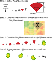
Wildfire likelihood is quantified in a computationally efficient manner using a multi-scale ‘neighbourhood index’. This is achieved by aggregating fire behaviour properties across multiple neighbourhood scales. The index is much more computationally efficient than alternative approaches and considers contagious and directionally specific fire behaviour properties across multiple spatial ‘neighbourhood’ scales.
This article belongs to the Collection Fire & Climate.
We develop a robust greenhouse gas (GHG) emissions accounting framework for miombo woodland savannas covering ~2 million km2 of southern Africa that typically burn under fairly severe late dry season conditions. We demonstrate that prescribed early dry season fire treatments can reduce GHG emissions by up to half.
This article belongs to the Collection Savanna burning.
This study assesses the predictive value of synoptic-scale upper-air map types in near-term fire weather forecasting in the US Pacific Northwest. A set of 13 patterns of 500-hPa geopotential heights are associated with spatially heterogeneous variation in wildfire activity within the region.
The 1986 Annaburroo grassland fire experiments conducted in the Northern Territory, Australia, created a unique dataset of fire behaviour across a range of fuel and burning conditions. This dataset, comprising detailed observations of fuels, weather and fire behaviour in 121 plots, is now publicly available via the CSIRO Data Access Portal.


