
Tracking and short-term forecasting of mesoscale convective cloud clusters over southeast Brazil using satellite infrared imagery
José Ricardo Siqueira A B and Valdo da Silva Marques AA Laboratório de Meteorologia, Centro de Ciência e Tecnologia, Universidade Estadual do Norte Fluminense, Avenida Brennand, S/N, Parque Industrial Bellavista. Imboassica. Macae/RJ, Brazil, 27925-535.
B Corresponding author. Email: siqueirajricardo@gmail.com
Journal of Southern Hemisphere Earth Systems Science 71(1) 1-16 https://doi.org/10.1071/ES19050
Submitted: 22 May 2020 Accepted: 22 11 2020 Published: 17 February 2021
Journal Compilation © BoM 2021 Open Access CC BY-NC-ND
Abstract
This paper presents the tracking and short-term forecasting of mesoscale convective cloud clusters (CCs) that occurred over southeast Brazil and the adjacent Atlantic Ocean during 2009–17. These events produce intense rainfall and severe storms that impact agriculture, defence, hydroelectricity and offshore oil production. To identify, track and forecast CCs, the Geostationary Operational Environmental Satellite infrared imagery and the Forecasting and Tracking the Evolution of Cloud Clusters method are used. The forecast performance is investigated by applying statistical analyses between the observed and forecasted CCs’ physical properties. A total of 7139 mesoscale convective CCs were identified, tracked and selected for the short-term forecasting at their maturation phases. The CC tracking showed a high frequency of CCs over the Atlantic Ocean and mainly over continental and coastal southeast Brazil during the wet season. This indicates an important role played by the cold fronts and convective diurnal forcing on the organisation of convective cloudiness over that region. The majority of the CCs reached their maturation phases within the first 2 h of life cycle, which occurred mostly between the late afternoon and evening. The CCs had short lifetimes and were predominantly in meso-β scales, followed by meso-α convective CCs. The CCs showed cloud-top temperatures typical of clouds with strong vertical development and potential to produce rainfall. The short-term forecasting of CCs at their maturation phases revealed different behaviours of the statistical indices with forecast range. For the 30–60-min timeframe, the forecasts performed relatively well. For longer forecast lead times (90–120 min), the forecasts overestimated the occurrences, intensities and growth of the CCs and forecasted the CCs to be further north and east of their actual observed locations. Overall, our results may contribute to improving the forecast quality of these intense weather events.
Keywords: Atlantic Ocean, cold fronts, diurnal forcing, mesoscale convective cloud cluster, short-term forecasting, southeast Brazil, thermal infrared satellite, weather.
1 Introduction
Southeast Brazil is a region strongly influenced by meteorological systems that produce intense rainfall throughout the year and especially in austral summer, autumn and spring. The most intense systems are known as mesoscale convective systems (MCSs). According to Orlanski (1975), the horizontal scales of the MCSs vary between 200 and 2000 km, and they can also be called meso-α convective cloud clusters (CCs). For this reason, these systems are responsible for a majority of the precipitation over tropical South America and are frequently characterised as severe storms (Zipser 1977; Maddox 1983; Houze 1993; Houze 2004; Zipser et al. 2006; Durkee et al. 2009). The CCs over tropical South America are also organised in horizontal scales between 20 and 200 km, called meso-β convective CCs (Orlanski 1975). Despite having a smaller area than the MCSs, the meso-β CCs are also frequently associated with heavy rainfall over tropical South America, such that they must be intensively studied as well (Siqueira and Marques 2016).
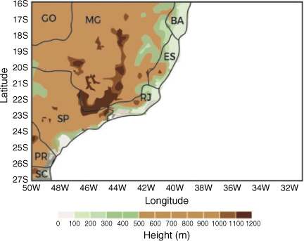
Due to the large social and economic impact of meso-α convective CCs in southeast Brazil, a better knowledge of these systems is very important for the improvement of weather forecast models in Brazilian weather forecast centres, as well as for civil defense institutions, agriculture and hydroelectricity. Knowledge about meso-α convective CCs are also very important for several oil production companies located over the South Atlantic Ocean, which are most up to 100 km distant from the coast of southeast Brazil. These companies need continuous information about severe weather conditions to execute their different operational activities offshore more safely and profitably (oil production, supply of platforms, air and maritime transport, for example). The political and topographic maps of southeast Brazil are shown in Fig. 1 for more details.
|
The use of geostationary satellite infrared imagery with fine time and space sampling and large geographical coverage has allowed for the identification and tracking of meso-α convective CCs during their life cycles in different regions of the Earth (especially along and east of major mountain ranges, such as east of the Rocky Mountains in the United States and east of the Andes Mountains in South America) and knowing their structural characteristics (Velasco and Fritsch 1987; Machado and Rossow 1993; Machado et al. 1998; Vila and Machado 2004; Siqueira et al. 2005; Zipser et al. 2006; Siqueira and Marques 2008; Siqueira and Marques 2010; Walker et al. 2012; Rasmussen et al. 2014; Yang et al. 2015). Among several important results obtained in this context, some of the above authors observed that the mean meso-α convective CCs size was directly related to their lifetimes, and some authors identified the tridimensional structure of these systems by combining images of passive and active sensors (radar) onboard meteorological satellites.
The meso-α convective CCs forecasting by conventional weather forecast models has been an extremely difficult task due to the relatively small time scale associated with the development of these systems, as well as the following conditions that may favour their developments: topography, association with synoptic systems, atmospheric humidity, convective available potential energy and diurnal cycle of convection (Kolios and Feidas 2013). Some authors have made the short-term forecasting (up to 120 min) of meso-α convective CCs in several regions of the Earth by applying different techniques to geostationary satellite infrared imagery (Vila et al. 2008; Walker et al. 2012; Kolios and Feidas 2013). In these previous studies, it was possible to make more accurate forecasts than the forecasts made by conventional models. That is due to the best spatial and temporal resolutions of the satellites, which also allowed more detailed tracking and forecasting of the rapid evolution of meso-α convective CCs. To forecast these systems over the Amazonian region, Vila et al. (2008) developed the Forecasting and Tracking the Evolution of Cloud Clusters (ForTraCC) method. This method is a linear extrapolation method combined with a method of meso-α convective CCs tracking throughout their life cycles. The ForTraCC method makes the identification, tracking and short-term forecasting of the kinematic, morphological and radiative characteristics of these systems using infrared imagery (channel 4) of the Geostationary Operational Environmental Satellite (GOES-13). This method has become operational in Centro de Previsao do Tempo e Estudos Climaticos/Instituto Nacional de Pesquisas Espaciais for tracking and forecasting of meso-α and meso-β convective CCs over South America since 2004.
The goal of this paper is to present the tracking and short-term forecasting of meso-α and meso-β convective CCs that occurred over southeast Brazil and the adjacent Atlantic Ocean during 2009–17. For identification, tracking and forecasting of these systems, the ForTraCC method was applied to GOES-13 infrared imagery. The forecast quality was investigated by applying statistical analyses between the observed (tracked) and forecasted CC properties and by evaluating the following statistical indices: accuracy, bias score, probability of detection and false alarms rate. In Section 2 we describe the satellite dataset used in this study. Section 3 provides the method employed for the tracking and forecasting of CCs, as well as the verification methodology. The results of the tracking and short-term forecasting of CCs are described in Section 4. Section 5 presents our summaries and conclusions.
2 Data
The brightness temperatures of channel 4 (11 µm) of GOES-13 satellite were used in this study. The data were extracted for the region 16°S–27°S, 30°W–50°W, for 2009–17. The selected region essentially includes southeast Brazil and the adjacent Atlantic Ocean (Fig. 1). The spatial resolution of the data at the sub-satellite point is approximately 4 × 4 km, and the temporal resolution is 30 min.
3 Method
3.1 CC identification and tracking
The mesoscale convective CCs that occurred over southeast Brazil during 2009–17 were firstly identified and tracked by applying a ForTraCC tracking technique developed and detailed by Vila et al. (2008) to obtain the evolution of the kinematic, morphological and radiative properties of CCs during their life cycles. The tracking technique is based on the similarity of the morphological characteristics and overlapping area between CCs in successive GOES-13 satellite infrared images (channel 4). The main elements of the tracking technique are: (1) a CC detection routine based on a size and two brightness temperature thresholds; (2) a statistical routine to identify and estimate kinematic, morphological and radiative properties of CCs found in the previous step (Machado et al. 1998; Vila and Machado 2004; Vila et al. 2008); (3) a tracking routine based on CC overlapping area between successive images, which allows making CC trajectories throughout their life cycles, arranged in ‘families’ (Laurent et al. 2002); and (4) a virtual (or synthetic) imaging routine used to fill missing satellite images (see Fig. 2 as an example of the application of the tracking technique).

|
To identify and track mesoscale convective CCs, the ForTraCC tracking technique uses the brightness temperature thresholds of 235 K (referent to CCs) and 210 K (referent to convective cells, that is, a region of high-speed updrafts within cumulonimbus clouds). According to Machado et al. (1998), each CC with a horizontal scale larger than 200 km that exhibits similar cloud morphologic characteristics throw the time in GOES images and contains convective cells at some time of its lifecycle is classified as a MCS. A similar procedure has been used to define and identify the mesoscale convective CCs, but each CC with horizontal scale larger than 20 km (equivalent to 20 or more satellite pixels) is selected and referred to as mesoscale convective CCs in the analysis. If the maximum horizontal scale of the CC is smaller (larger) than 200 km, the CC is classified as meso-β convective CC (MCS). For tracking CCs from successive images following the methodology of Vila et al. (2008), a minimum overlapping area of 25% has been used for two 30-min consecutive images (Figs 2a and 2b). If one of the CCs splits, the tracking technique will track the system that most closely resembles the original (usually the larger one); the other CCs will be tracked as separate systems. If one of the CCs merges with a smaller system, the tracking technique continues to track, but if it merges with a larger system, its life cycle is terminated.
The main CC properties estimated by the tracking technique are: central latitude and longitude (latitude and longitude of the CC centre of mass), time of the maturation phase (largest area of convective cells within CC), lifetime, propagation direction in meteorological coordinates (angle measured from north), propagation speed, effective radius (radius of a circle with the same area as the CC), size (total number of CC pixels), area expansion rate (rate of change of the CC size divided by the CC size), convective fraction (size of convective cells within CC divided by the CC size), mean and minimum brightness temperatures, rate of change of the mean brightness temperature, and mean rainfall rate estimated by the Autoestimator technique (Vicente et al. 1998) (Fig. 2c). The tracking technique computes the area expansion rate and the rate of change of the mean brightness temperature for a specific time using two successive satellite images. The first image corresponds to the specific time, and the second one corresponds to the previous time (at a 30-min earlier time). All CC properties were collected for the initiation (INI), maturation (MAT), and decay (DEC) phases of the CC life cycle. The first (last) time at which CCs are present in the satellite data is defined as INI (DEC) phase, while the time at which CCs acquire their largest convective fractions corresponds to the MAT phase. A total of 8486 CCs were identified and tracked during this phase of analysis.
3.2 CC forecasting
The short-term forecasting of mesoscale convective CCs was made for the same region and period described previously by applying a ForTraCC forecasting technique developed and detailed by Vila et al. (2008) to GOES-13 satellite infrared images (channel 4). The forecasting technique estimates the location and intensity of CCs at later times based on CC evolution in previous time steps, as follows (see Fig. 3 as an example of application of the forecasting technique). Starting from the identification and tracking of a given CC in three successive times (t − 2Δt, t − Δt and t) during a life cycle, the estimated displacement vector in the previous time interval, V(t − Δt), is performed considering the displacement of the geometrical centre of mass between t − 2Δt and t − Δt. Considering that this displacement does not change very much at such a time scale (30 min), a predicted velocity VP(t) is generated. Simultaneously, the real CC displacement, V(t), is also computed considering the t − Δt and t time intervals. The estimation of the CC vector displacement, VE(t + Δt), is made as V(t) plus the difference between the real displacement and the predicted velocity [ΔV(t) = V(t) − VP(t)] in the last time step (Fig. 3a). If two successive time steps for the same CC are not available, the CC vector displacement is computed as the displacement of the centre of mass between t − Δt and t. In cases of splitting or merging of CCs, the displacement is performed as a distance-weighted average displacement of the neighbouring CCs.

|
The life cycle phase of the CCs (growth–decay) is evaluated by the forecasting technique using the area expansion rate (also called normalised area expansion and represented as ΔE). Based on the MCS statistics obtained from the Wet Season Atmospheric Mesoscale Campaign of the Large-Scale Biosphere–Atmosphere Experiment experiment performed by Silva Dias et al. (2002), four life cycle duration classes are used: (1) families with life cycles with a duration of less than 2 h, (2) those lasting between 2 and 4.4 h, (3) those lasting between 4.4 and 8.4 h and (4) those lasting longer than 8.4 h. For each duration class, three mean values of ΔE are evaluated at the: (a) initial phase, (b) maturation phase and (c) decay phase of the MCSs, being these points plotted and connected with lines (Fig. 3b). This MCS life cycle model (family of curves) is used to estimate the probable evolution of each CC in the following way. Consider that a CC is being tracked during its life cycle and the last available information about its size is known at time t1. The elapsed time from the initial phase (t0) to the last available image is T1 = t1 − t0. At the same time, ΔE1 can be computed for the last two successive images. Using a linear regression analysis, a unique linear equation is selected from the family of curves that represents the possible evolution of all CCs (see Vila et al. (2008) for more details). In opposition to the tracking technique, the forecasting technique uses neither brightness temperature thresholds nor overlapping to forecast CCs at later times. In other words, the forecasts of CCs are made using only the CC’s possible displacement (considering the centre of the mass position of the tracked CC in previous time steps) and its size evolution.
In this paper, the forecasts were made only for mesoscale convective CCs at their maturation phases for the following lead times (after the maturation phase): 30, 60, 90 and 120 min (Fig. 3c). The types of CC properties estimated by the forecasting technique that were selected at this part of the study are basically the same estimated by the ForTraCC tracking technique (Fig. 3d). It is important to point out that the total number of CCs selected for forecasting was smaller than the total number of tracked CCs. This is due to some restrictions of the forecasting technique for forecasting CCs (the technique needs information about the tracked CC properties at the last 30 min before the CC maturation phase, but some tracked CCs exhibit coincident initiation and maturation phases, so they had to be removed from the analysis). This resulted in a total of 7139 forecasted CCs (84.1% of the total number of the tracked CCs). Another point is the high frequency of splitting and/or merging events found within the CCs selected for forecasting. The splitting and merging events occurred in 59% and 56% of the total CCs number, respectively. Only 27% of the total CCs number had none of these events during their entire life cycles (30.5% of the continental CCs, 16.1% of the oceanic CCs and 14.7% of the coastal CCs number).
3.3 The verification methodology
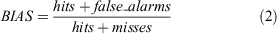
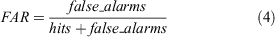
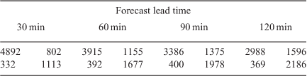
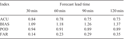
The forecast quality was evaluated by comparing the observed and forecasted CC properties and using statistical analyses. Four important statistical indices were computed from the contingency table (Table 1). The contingency table consists of the following elements: number of hits, number of misses, number of false alarms and number of correct negatives (Wilks 1995; Walker et al. 2012). If the ForTraCC forecasting technique forecasts the existence of a CC at later time and this CC is also identified by the ForTraCC tracking technique at the same later time, a ‘hit’ is considered. Similarly, if the CC is not forecasted by the forecasting technique but it is identified at later time by the tracking technique, a ‘miss’ is considered (and so on for the other elements). The statistical indices used in this study are: accuracy (ACU), bias score (BIAS), probability of detection (POD), and false alarms rate (FAR). The ACU index measures the fraction of the CC forecasts that is correct, and it ranges from 0 (less accurate forecast) to 1 (more accurate forecast). The BIAS score indicates the rate of the forecasted CCs with respect to the observed CCs. This index ranges from 0 to infinity, and it allows evaluating if the forecasting method tends to underestimate the CC occurrence (BIAS < 1) or to overestimate it (BIAS > 1). No bias corresponds to a value equal to 1 (perfect forecast).
|
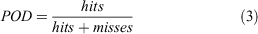
The POD index relates the correctly forecasted CCs to the correctly and incorrectly forecasted CCs. This index measures the performance of the CC detection, and it ranges from zero to one (perfect forecast). The FAR index represents the fraction of the forecasted CCs that did not occur. This index ranges from zero (perfect forecast) to 1. The ACU, BIAS, POD, and FAR are given by (Wilks 1995):

For the correctly forecasted CCs (hits), the differences between the forecasted and tracked CC properties were also estimated in this study to evaluate the forecast quality, as well as their corresponding cumulative frequency distributions and root mean square errors (RMSEs). The RMSE is given by:
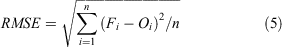
where Fi are the forecasted values for a specific CC property, Oi are the observed values and n is the total number of correctly forecasted CCs.
4 Results
4.1 CC tracking
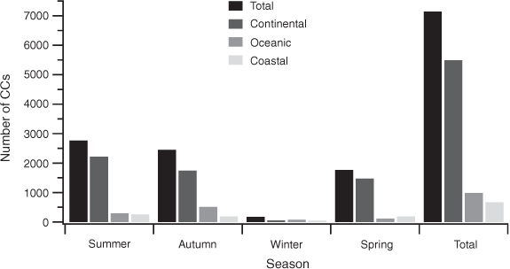
Fig. 4 shows the seasonal and total distributions of the 7139 tracked mesoscale convective CCs. A population of 5488 CCs (76.9% of the total CCs number) are defined as continental systems, that is, they initiated and decayed over continental southeast Brazil. A population of 982 CCs (13.8% of the total CCs number) are defined as oceanic systems, that is, they initiated and decayed over oceanic southeast Brazil. In addition, 669 CCs (9.3% of the total CCs number) are defined as coastal systems, that is, they initiated over continental (oceanic) southeast Brazil and decayed over oceanic (continental) southeast Brazil. Despite the oceanic area of the study being slightly larger than the continental area, the number of continental CCs was much higher than the number of oceanic CCs. Although the coastal CCs are less numerous than the oceanic CCs, the number of coastal CCs were not much lower than the number of oceanic CCs.
|
The high number of CCs over the studied region found previously shows the important role of orographic and thermal forcing, cold fronts and other synoptic systems in organising convective cloudiness and precipitation regimes over southeast Brazil and the adjacent Atlantic Ocean. This aspect was evidenced by Siqueira and Marques (2008 and 2010) for MCSs identified over the same studied region during 1998–2000 by using a similar cloud tracking technique and reanalysis data. As an example, Fig. 5 shows the mean daily fields of horizontal wind at 300 hPa for two different synoptic situations (cold frontal and non-frontal) adapted from Siqueira and Marques (2008). The main circulation features found for the cold frontal incursion case consist of strong westerly and southwesterly winds moving towards northeast South America and the tropical Atlantic Ocean, being representative of the penetration of a midlatitude cold front over southeast Brazil that moves towards the tropics. For the non-frontal incursion case, the presence of strong westerly and northwesterly winds moving towards the tropical Atlantic Ocean were the main features found over southeast Brazil. Another important feature observed for both cases was the predominantly zonal circulation at 300 hPa, which favours the zonal movement (from continental towards oceanic areas) of the majority of MCSs studied by the above authors. We suspect the large number of continental CCs is due to intense continental diurnal forcing and strong land-ocean heating contrast, which favours rapid and strong convective growth over southeast Brazil. This is consistent with the diurnal cycle of deep convection over tropical land and oceanic areas described by Garreaud and Wallace (1997). Another important point is the very larger number of meso-β CCs (78% of the total CCs number) identified over the studied region, followed by a smaller (but also significant) number of MCSs (22% of the total CCs number, not shown).

|
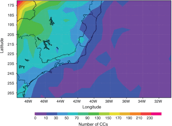
The seasonal frequency distributions of the tracked CCs are similar to their total distributions, except in austral winter, in which the number of oceanic CCs was slightly higher (Fig. 4). The CCs number in winter was very small, which is consistent with the climatology of convection over southeast Brazil (Satyamurty et al. 1998). The largest frequency of the continental CCs was also observed for meso-β CCs and MCSs individually (not shown). In addition, these distributions were quite different from the ones obtained by Siqueira and Marques (2008), who found a comparable number of continental and oceanic MCSs followed by a much lower number of coastal MCs. These differences may be related to the poorer horizontal and time resolutions of the satellite images (30 km and 3 h, respectively) used by the above authors, resulting in fewer coastal MCSs identified. The spatial distribution of the 7139 tracked CCs at the maturation phase of the CC lifecycle shown in Fig. 6 reveals CCs were more concentrated over continental southeast Brazil and more widely distributed over oceanic southeast Brazil (see comment above on the reasons why these spatial distributions are this way).
|
Fig. 7 shows cumulative distributions of the 7139 tracked CCs versus their main kinematic and morphological properties. The distributions of the UTC time of mature phase show almost 70% of CCs reaching their maturation phases between 15 and 23 UTC (12–20 LST). These distributions are favoured by the larger number of continental CCs identified and the diurnal cycle of deep convection over land areas, which is characterised by maximum of convective cloudiness in the late afternoon and early evening (Garreaud and Wallace 1997; Siqueira and Marques 2010). Approximately 70% of CCs reached their maturation phases within the first 2 h of CC life cycle, while the remaining systems reached their maturation phases between 2 and 10 h, as shown by their distributions of the time of mature phase (Fig. 7). By examining the distributions of the CC lifetime, 70% of CCs last up to 6 h, while the remaining systems last longer (6–30 h). The lifetimes of most CCs were shorter than the ones estimated by Siqueira and Marques (2010) for MCSs. This is probably due to the large number of smaller systems (especially the meso-β CCs) in the present study.

|
The distributions of the CC propagation speed show 80% of CCs moving at 12 m/s at the initiation phase, which are also typical of synoptic systems (Fig. 7). This number decreases to 60% at the other phases of the CC life cycle, indicating that CCs tend to move slightly faster as they develop over southeast Brazil and the adjacent Atlantic Ocean. The cumulative distributions of the CC propagation direction revealed 70% of CCs moving predominantly northward, northeastward or closer to the zonal direction during the CC life cycle (not shown). These distributions are justified by the atmospheric circulation patterns established by the passage of cold fronts, the temperature contrasts and the large-scale stratification over southeast Brazil (Siqueira and Marques 2008).
By analyzing the cumulative distributions of the CC effective radius, 90% of CCs with radii between 10 and 100 km (equivalent to horizontal scales between 20 and 200 km, that is, meso-β CCs) are observed at the initiation and decay phases of the CC life cycle, so that the majority of these systems have radii between 10 and 60 km (Fig. 7). The remaining CCs have effective radius between 100 and 300 km (equivalent to horizontal scales between 200 and 600 km, that is, MCSs) at their initiation and decay phases, being predominantly between 100 and 160 km. Slightly larger effective radii are observed at the maturation phase, increasing the number of MCSs. This last result is a consequence of the maximum CC area occurring closer to the maturation phase, as also found by Machado et al. (1998). The scales of the studied MCSs were relatively similar to the ones found by Siqueira and Marques (2010).
The cumulative distributions of the CC area expansion rate show 50% of CCs containing negative growth rates, 25% with null growth rates and only 25% with positive growth rates at the initiation phase of the CC life cycle (Fig. 7). Although the high number of CCs containing negative rates at the initiation is not consistent with the MCSs life cycle from literature, this result can be explained as follows. The calculation of the CC area expansion rate at the initiation phase by the ForTraCC tracking technique is only possible in case of splitting events because this is the unique situation in which a previous image to the one at the initiation phase is known (also necessary for this calculation). Hence, the high frequency of splitting events within the studied CCs allowed computing these rates at the initial phase. These rates were predominantly negative for CCs at the initiation due to these systems having been formed by splitting events that occurred in older CCs. A very larger number of CCs containing positive rates is observed at the maturation phase (50% of CCs), but this number decreases at the decay phase. These distributions characterise a strong areal expansion of CCs at their maturation phases, which is more consistent with the life cycle of MCSs. For the distributions of CC convective fraction, approximately 80% of CCs contain convective fractions of 0–0.1 at the initiation and decay phases (Fig. 7). At the maturation phase, 80% of CCs have larger convective fractions (0–0.3) due to the largest area of convective cells within CCs at the maturation phase.
The distributions of the CC mean brightness temperature shown in Fig. 8 reveal CCs with cloud-top temperatures preferentially between 205 and 235 K throughout the CC life cycle. A considerably higher CCs number with cloud-top temperatures colder than 220 K is noted at the CC maturation phase (50% of CCs versus 26% of CCs at the decay and 18% of CCs at the initiation phase). The means of these distributions resulted in temperatures of 224 K at the initiation, 220 K at the maturation and 225 K at the decay phase. These values indicate the presence of clouds with strong vertical development (colder cloud-tops) throughout the CC life cycle and especially at their maturation phases, at which the largest area of convective cells within CCs tends to strongly reduce their cloud-top temperatures. The distributions of the CC minimum brightness temperature are relatively similar to the previous ones (Fig. 8), except for the colder cloud-top temperatures (preferentially 185–235 K) and larger differences found during the CC life cycle. The means of these distributions also resulted in very colder cloud-top temperatures (212 K at the initiation, 204 K at the maturation and 214 K at the decay phase).

|
By examining the distributions of the CC rate of change of the mean brightness temperature, 50% of CCs contain negative rates, 30% contain positive rates and only 20% contain null rates at the initiation phase, as shown in Fig. 8. Despite the large number of CCs containing null and positive temperature rates at the initiation, this is not consistent with the MCSs life cycle from literature; this result is also explained by the occurrence of splitting events (and consequent weakening) of older CCs, as discussed previously for CC area expansion rates. At the maturation phase, negative rates of change are observed for a considerably larger CCs number, while a relatively similar distribution to the one observed at the initiation phase is found at the decay phase. These last distributions reveal a faster and more intense vertical development of CCs during their maturation phases, while at the other phases this development is relatively similar.
The cumulative distributions of the CC mean rainfall rates estimated by the Autoestimator technique exhibits 80% of CCs containing rates of 0–8 mm/h at the initiation and decay phases, as shown in Fig. 8. At the maturation phase, 80% of CCs contain larger rates (0–12 mm/h), which is probably due to the most intense convective activity of CCs at this phase. The remaining systems present rates of 8–16 mm/h at the initiation and decay phases and 12–20 mm/h at the maturation phase. This result shows the impact of CCs on the precipitation regimes over southeast Brazil and the adjacent Atlantic Ocean in recent years. The distributions of mean rainfall rates of most CCs were relatively similar to the ones estimated by Siqueira and Marques (2010), who found rainfall rates of 11–18 mm/h for MCSs at the maturation phase.
4.2 Short-term forecasting of CCs
Tables 2 and 3 show the contingency tables and the values of the four statistical indices, respectively, which were estimated to evaluate the forecasts of the 7139 studied mesoscale convective CCs. For the ACU index, a large value (close to 1) is noted for 30-min forecasts, indicating a relatively good performance with respect to the accuracy (Table 3). For longer lead times, the ACU index decreases up to 18% from its 30-min value for 120-min forecasts. This shows a decreased performance for longer lead times and especially from 120 min, which is due to a strong decrease in the number of hits for longer lead times. This strong decrease is caused by an increase in the number of misses and especially in the number of false alarms generated by the forecasts for longer forecast lead times (Table 2). It is also important to note that the strong increase in the number of correct negatives with forecast range generated by the forecasts was not enough to keep the ACU index large (as for 30-min forecasts) for longer lead times (Table 2). This level of performance was worse than the one obtained by Vila et al. (2008) for forecasting of MCSs in the Amazon basin using the ForTraCC method, especially for longer lead times. On the other hand, this performance was relatively similar to the one estimated by Walker et al. (2012) for forecasting of MCSs over four regions in the United States using the Satellite Convection Analysis and Tracking (SATCASTv2) method.
|
|
By analysing the BIAS score of the CC forecasts, values >1 are observed for all forecast lead times. This indicates a tendency of the forecasts to overestimate the occurrence frequencies of the studied CCs (Table 3). For 30-min forecasts, the BIAS score is close to 1, showing a relatively good performance with respect to the false alarms and misses. For longer lead times, this index increases up to 26% from its 30-min value for 120-min forecasts. This also reveals a decreased performance for longer lead times and especially from 90 min. As the BIAS score depends directly on the number of false alarms (and this number increased considerably with forecast range), the increase in the BIAS score with forecast range was larger than the increase in the ACU index (Table 2). This also confirms the tendency of the forecasts to overestimate the occurrence frequencies of the studied CCs for longer lead times. The BIAS index had an opposite behaviour with respect to the one presented by Vila et al. (2008). These authors found BIAS < 1 for all forecast lead times (underestimating the MCS occurrences) and a smaller decreasing in the performance with forecasting range.
For the POD index, a large value (close to 1) is observed for 30-min forecasts, indicating a relatively good performance with respect to the misses (Table 3). This index decreased with a forecast range only 5% from its 30-min value for 120-min forecasts. As the POD index depends directly on the number of misses (and the variation of this number with forecast range was relatively small, as shown in Table 2), this index presented the smallest variations with forecast range. Consequently, the performance for 30-min lead time was also extended to the longer forecast lead times. This performance was better than the ones obtained by Vila et al. (2008) and Walker et al. (2012) for forecasting of their respective studied MCSs.
The FAR index of the CC forecasts is very small (close to 0) for 30-min forecasts, indicating a relatively good performance with respect to the false alarms (Table 3). However, an increase of approximately 150% from its 30-min value is verified for 120-min forecasts. This shows a decreased performance for longer lead times and especially from 90 min. The increase in the FAR with forecast range was the largest found among the four statistical indices used, and it was due to the strong increase in the number of false alarms with forecast range, the consequent decrease in the number of hits, and the direct relationship between this index and both parameters (Table 2). Despite this, the performance was much better than the ones found by Vila et al. (2008) and Walker et al. (2012) for forecasting of their respective MCSs.
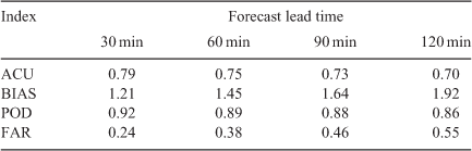
To investigate the impact of the splitting and merging of CCs on the forecasts’ quality, a similar statistical analysis was also made for the CCs with no splitting and/or merging. This CCs population corresponded to 27% of the total forecasted CCs number. Table 4 shows the values of the four statistical indices estimated for this CCs population. The ACU and POD indices were slightly smaller with respect to their previous values, and the BIAS and FAR were only a little larger with respect to their previous values (Tables 3 and 4). These results reveal a small loss of quality in the forecasts for the CCs without splitting and/or merging, especially for longer 60-min lead times. This may be justified by a larger number of false alarms found in this case (the percentage value of the number of false alarms with respect to the total number of forecasts was up to 5% larger in this case, not shown), despite a smaller number of misses found in this case (up to 2% smaller, not shown).
|
Fig. 9 shows the cumulative distributions of the forecasted CCs containing correct positive forecasts (hits) versus the differences between the main forecasted and observed CC kinematic and morphological properties. By examining the differences between the forecasted and observed CC central latitude, 65% of CCs presented null differences for 30-min forecasts. However, latitude differences between 0° and 0.3° are found within 30% of CCs, while differences between –1.2° and 0° are present within 5% of CCs. The corresponding RMSE is approximately 0.3°, which is equivalent to a meridional distance of 30 km. These distributions reveal a tendency of the forecasts to estimate the CC centre of mass too far north with respect to the observed values. For 60-min forecasts, slightly larger latitude differences are observed with respect to 30-min forecasts. For 90- and 120-min forecasts, the differences increase considerably, increasing the RMSE to 0.5° (or 50 km) for 120-min forecasts.

|
The cumulative distributions of differences between the forecasted and observed CC central longitude show 60% of CCs with null longitude differences, 35% of CCs containing differences between 0° and 0.3°, and only 5% of CCs containing differences between –1.5° and 0° for 30-min forecasts (Fig. 9). The corresponding RMSE reaches 0.44°, which is equivalent to a zonal distance of 44 km. These distributions show that the forecasts tend to estimate the CC centre of mass too far east with respect to the observed values. For 60-min forecasts, the distribution is slightly different to the one found for 30-min forecasts, showing some additional discrepancy. However, the discrepancy increases substantially for 90- and 120-min forecasts, increasing the RMSE to 0.7° (or 70 km) for 120-min forecasts.
By evaluating the cumulative distributions of differences between the forecasted and observed CC speed, we have found differences between –30 and 0 m/s within 50% of CCs, 0–30 m/s within 30% of CCs and null differences within 20% of CCs for 30-min forecasts (Fig. 9). The corresponding RMSE is approximately 5.3 m/s. This shows an underestimation in the CC speed by the forecasts. These distributions are relatively constant with forecast range, which indicates a similar performance for all lead times. It is also important to report the decreased performance of the forecasts for the CC propagation direction, since 85% of CCs exhibited very small differences for 30-min forecasts, increasing considerably with forecast range (not shown). As a result, 75% of CCs exhibit distances between their forecasted and observed centres up to 20 km for 30-min forecasts, increasing up to 60 km for 120-min forecasts (not shown). Despite that, the performance for the CC distances were much better than the ones found by Vila et al. (2008) for all forecast lead times.
The differences between the morphological properties of the forecasted and observed CCs showed no tendency for forecasts to underestimate (nor overestimate) the CC sizes, in opposition to the tendency for underestimation of the MCS sizes found by Vila et al. (2008). The cumulative distributions of differences between the forecasted and observed CC effective radius show differences between –50 and 0 km within 45% of CCs, 0–50 km within 40% of CCs and null differences within 15% of CCs for 30-min forecasts (Fig. 9). The corresponding RMSE reaches 25 km. A relatively similar distribution to the previous one is noted for 60-min forecasts. For 90- and 120-min forecasts, the discrepancy increases considerably, resulting in a RMSE of 36 km for 120-min forecasts. For the differences between the observed and forecasted CC convective fraction, we have found values of 0–0.35 within 70% of CCs and null values within 30% of CCs for 30-min forecasts (Fig. 9). The corresponding RMSE is approximately 0.08. The distributions of convective fractions reveal an overestimation of the area of convective cells within the studied CCs by the forecasts, which tends to forecast more intense systems than the observed ones. It is also noted that these distributions vary considerably with forecast range (especially from 60 min), such that the corresponding RMSE increases to 0.19 for 120-min forecasts. By analysing the cumulative distributions of differences between the forecasted and observed CC area expansion rate, 47% of CCs showed negative differences, 40% showed positive differences and only 13% showed null differences for 30-min forecasts (Fig. 9). The corresponding RMSE reaches 191 s−1. Relatively similar distributions are found for longer forecast lead times. This indicates a similar forecast performance for the area expansion of the CCs for all lead times.
By examining the differences between the forecasted and observed CC mean brightness temperature shown in Fig. 10, values between –10–0 K, 0–4 K and 0 K are found within 60%, 24% and 16% of CC, respectively, for 30-min forecasts. The corresponding RMSE is approximately 2.3 K, showing a tendency of the forecasts to underestimate the CC mean cloud-top temperatures. This tendency was opposite to the one found by Vila et al. (2008). So, the forecasts tend to result in CCs with stronger vertical development of clouds (colder cloud-tops), resulting in even more intense forecasted systems than the observed ones (by also considering the larger forecasted area of convective cells within the CCs). For 60-, 90- and 120-min forecasts, this tendency is maintained and the forecasts discrepancy increases considerably from 60 min, resulting in a RMSE of 5.9 K for 120-min forecasts. For the differences between the forecasted and observed CC minimum brightness temperatures (Fig. 10), the distributions are relatively similar to the previous ones, except for larger differences found for all forecast lead times (–27–0 K within 70% of CCs, 0–10 K within 16% of CCs and null differences within 14% of CCs for 30-min forecasts). The corresponding RMSE reaches 5.8 K for 30-min forecasts and 9.9 K for 120-min forecasts.

|
The cumulative distributions of differences between the forecasted and observed rate of change of the CC mean brightness temperature reveal negative differences within 60% of CCs, positive differences within 25% of CCs and null differences within 15% of CCs for 30-min forecasts (Fig. 10). The corresponding RMSE reaches 4.4 K/s. These distributions show that the forecasts tend to underestimate the rates of change, forecasting more rapid vertical development of the studied CCs (more rapidly growing). For 60-, 90- and 120-min forecasts, relatively similar distributions are found with respect to the ones of 30-min forecasts. This indicates a comparable performance for the vertical development of CCs for all forecast lead times. By examining the differences between the forecasted and observed CC mean rainfall rate, 60%, 24% and 16% of CCs present differences between 0–10 mm/h, –4–0 mm/h and 0 mm/h, respectively, for 30-min forecasts. The corresponding RMSE reaches 2.2 mm/h, showing that the forecasts tend to overestimate the CC rainfall rates. These distributions are consistent with the larger forecasted area of convective cells within the CCs, their colder forecasted cloud-tops and the most rapidly forecasted vertical development of clouds within the CCs described previously. For 60-, 90- and 120-min forecasts, this tendency is also maintained, and the forecasts’ discrepancies increase considerably (from 60 min), resulting in a RMSE of 5.7 mm/h for 120-min forecasts.
5 Conclusions
In this study, the tracking and short-term forecasting of mesoscale convective CCs (meso-α and meso-β) that occurred over southeast Brazil and the adjacent Atlantic Ocean during 2009–17 were presented using the ForTraCC method and GOES-13 satellite infrared imagery. We identified, tracked and selected 7139 mesoscale convective CCs for short-term forecasting of the maturation phase of the CC life cycle.
The CC tracking showed a higher frequency of systems over the Atlantic Ocean and mainly over continental and coastal southeast Brazil during the wet season, especially in austral summer and autumn. This indicates an important role played by cold fronts and other synoptic systems, as well as the convective diurnal forcing (orographic and thermal), on the organisation of convective cloudiness over the studied region. The large seasonal and spatial variability of the CC frequencies are associated with the climatology of deep convection over southeast Brazil and land-ocean heating contrasts. The CCs were predominantly in meso-β scales (78% of CCs), while the remaining CCs corresponded to MCSs (22% of CCs).
By analysing the evolution of the tracked CC physical properties, the majority of the CCs reached their maturation phases within the first 2 h of the life cycle, which occurred mostly between the late afternoon and evening (15–23 UTC). The CCs moved preferentially northward, northeastward or zonally, with speeds typical of cold fronts. The meso-β CCs had horizontal scales especially between 20 and 120 km, while the MCSs had horizontal scales preferentially between 200 and 560 km and lifetimes up to 6 h. The CCs showed large areal expansion and convective areas at their maturation phases. The CC mean brightness temperatures indicated the presence of clouds with strong vertical development at their maturation (mean and minimum cloud-top temperatures between 205–220 K and 185–205 K, respectively). The rates of change of the CC mean brightness temperatures were highly negative, indicating a rapid growth of CCs. The CC mean rainfall rates estimated by the Autoestimator method were large at their maturation (up to 12 mm/h).
The short-term forecasting of CCs at their maturation phases revealed different behaviours of the statistical indices with forecast lead time. The ACU index presented a large value (close to 1) for 30-min forecasts, indicating a relatively good performance with respect to the accuracy due to the large number of hits and correct negatives. This index decreased considerably with forecast range, showing a decreased performance for longer lead times, especially from 120 min. This level of performance was favoured by a drastic fall in the number of hits. The BIAS index presented values >1 for all forecast lead times, showing that forecasts tend to overestimate the CC occurrences over southeast Brazil. For 30-min forecasts, this index was close to 1, indicating a relatively good performance. This index increased significantly with forecasting range, indicating a decreased performance, especially from 90 min, due to a sharp increase in the number of false alarms. The POD index exhibited a large value (close to 1) for all lead times, indicating a relatively good performance with respect to misses. The FAR index presented a small value (close to 0) for 30-min forecasts, indicating a relatively good performance with respect to false alarms. This index increased considerably with forecast lead time, substantially decreasing the performance, especially from 90 min. The increase in the FAR index with forecasting range was also favoured by a significant increase in the number of false alarms with forecast lead time.
By investigating the impact of the splitting and merging of CCs on the forecasts, the ACU and POD indices were slightly smaller with respect to their previous values, and the BIAS and FAR were a little larger with respect to their previous values. These results reveal a small loss of quality in the forecasts for the CCs without splitting and/or merging, especially for longer 60-min lead times. This may be justified by a little larger number of false alarms found in this case (in spite of a slightly smaller number of misses found) as a consequence of shorter CCs (the CCs that merge tended to be longer, reducing the number of false alarms). Hence, the impact of the splitting and merging processes on the forecasts’ quality was predominantly on the forecasting of the CCs’ physical properties.
By examining the differences between the forecasted and observed CCs’ physical properties at their maturation phases, the forecasts showed a relatively better performance for forecast lead times between 30 and 60 min. For longer lead times (90–120 min), the forecasts frequently overestimated the intensities and growth of the studied CCs and estimated the systems too far north and east with respect to their observed locations. Comparative analyses of the forecast performance for CCs over specific areas in southeast Brazil (continent, coast or ocean), under different synoptic conditions (cold fronts or South Atlantic Convergence Zone) and with different sizes may also contribute significantly to improve the forecast quality. We hope to address some of these topics in future work.
Conflicts of interest
The authors declare that they have no conflicts of interest.
Acknowledgements
Satellite imagery was obtained from Laboratório de Meteorologia/Universidade Estadual do Norte Fluminense (LAMET/UENF). This study was also supported by Fundação de Amparo à Pesquisa do Estado do Rio de Janeiro (FAPERJ) Project Grant E-26/010.002606/2014. The authors also thank Divisão de Satélites Ambientais/Centro de Previsão de Tempo e Estudos Climáticos for the availability of the ForTraCC technique.
References
Durkee, J. D., Mote, T. L., and Shepherd, J. M. (2009). The contribution of mesoscale convective complexes to rainfall across subtropical South America. J. Climate 22, 4590–4605.| The contribution of mesoscale convective complexes to rainfall across subtropical South America.Crossref | GoogleScholarGoogle Scholar |
Garreaud, R. D., and Wallace, J. M. (1997). The diurnal march of convective cloudiness over the Americas. Mon. Wea. Rev. 125, 3157–3171.
| The diurnal march of convective cloudiness over the Americas.Crossref | GoogleScholarGoogle Scholar |
Houze, R. A. (1993). ‘Cloud dynamics.’ (Academic Press: Waltham, MA), 573 pp.
Houze, R. A. (2004). Mesoscale convective systems. Rev. Geophys. 42, 1–43.
| Mesoscale convective systems.Crossref | GoogleScholarGoogle Scholar |
Kolios, S., and Feidas, H. (2013). An automated nowcasting system of mesoscale convective systems for the Mediterranean basin using Meteosat imagery. Part II: Verification statistics. Meteor. Appl. 20, 296–307.
| An automated nowcasting system of mesoscale convective systems for the Mediterranean basin using Meteosat imagery. Part II: Verification statistics.Crossref | GoogleScholarGoogle Scholar |
Laurent, H., Machado, L. A. T., and Durieux, L. (2002). Characteristics of Amazonian mesoscale convective systems observed from satellite and radar during the WETAMC/LBA experiment. J. Geophys. Res. 107, 8054.
| Characteristics of Amazonian mesoscale convective systems observed from satellite and radar during the WETAMC/LBA experiment.Crossref | GoogleScholarGoogle Scholar |
Machado, L. A. T., and Rossow, W. B. (1993). Structural characteristics and radiative properties of tropical cloud clusters. Mon. Wea. Rev. 121, 3234–3260.
| Structural characteristics and radiative properties of tropical cloud clusters.Crossref | GoogleScholarGoogle Scholar |
Machado, L. A. T., Rossow, W. B., Guedes, R. L., and Walker, A. W. (1998). Life cycle variations of mesoscale convective systems over the Americas. Mon. Wea. Rev. 126, 1630–1654.
| Life cycle variations of mesoscale convective systems over the Americas.Crossref | GoogleScholarGoogle Scholar |
Maddox, R. A. (1983). Large-scale meteorological conditions associated with midlatitude, mesoscale convective complexes. Mon. Wea. Rev. 111, 1475–1493.
| Large-scale meteorological conditions associated with midlatitude, mesoscale convective complexes.Crossref | GoogleScholarGoogle Scholar |
Orlanski, I. (1975). A rational subdivision of scales for atmospheric processes. Bull. Amer. Meteor. Soc. 56, 527–530.
| A rational subdivision of scales for atmospheric processes.Crossref | GoogleScholarGoogle Scholar |
Rasmussen, K. L., Zuluaga, M. D., and Houze, R. A. (2014). Severe convection and lightning in subtropical South America. Geophy. Res. Lett. 41, 7359–7366.
| Severe convection and lightning in subtropical South America.Crossref | GoogleScholarGoogle Scholar |
Satyamurty, P., Nobre, C. A., and Silva Dias, P. L. (1998). South America. Meteor. Monogr. 27, 119–139.
| South America.Crossref | GoogleScholarGoogle Scholar |
Silva Dias, M. A. F., Rutledge, S., Kabat, P., et al. (2002). Cloud and rain processes in a biosphere–atmosphere interaction context in the Amazon region. J. Geophys. Res. 107, 8072.
| Cloud and rain processes in a biosphere–atmosphere interaction context in the Amazon region.Crossref | GoogleScholarGoogle Scholar |
Siqueira, J. R., and Marques, V. S. (2008). Occurrence frequencies and trajectories of mesoscale convective systems over southeast Brazil related to cold frontal and non-frontal incursions. Aust. Meteor. Mag. 57, 345–357.
Siqueira, J. R., and Marques, V. S. (2010). Structural characteristics of mesoscale convective systems over southeast Brazil related to cold frontal and non-frontal incursions. Aust. Meteor. Ocean. Journal 60, 49–62.
| Structural characteristics of mesoscale convective systems over southeast Brazil related to cold frontal and non-frontal incursions.Crossref | GoogleScholarGoogle Scholar |
Siqueira, J. R., and Marques, V. S. (2016). Case Study of Intense Mesoscale Convective Systems Occurred between 02 and 03 January 2013 in the State of Rio de Janeiro: Structural and Thermodynamic Characteristics. Anuar. Inst. Geo. 39, 57–76.
| Case Study of Intense Mesoscale Convective Systems Occurred between 02 and 03 January 2013 in the State of Rio de Janeiro: Structural and Thermodynamic Characteristics.Crossref | GoogleScholarGoogle Scholar |
Siqueira, J. R., Rossow, W. B., Machado, L. A. T., and Pearl, C. (2005). Structural characteristics of convective systems over South America related to cold frontal incursions. Mon. Wea. Rev. 133, 1045–1064.
| Structural characteristics of convective systems over South America related to cold frontal incursions.Crossref | GoogleScholarGoogle Scholar |
Velasco, I., and Fritsch, J. M. (1987). Mesoscale convective complexes in the Americas. J. Geophys. Res. 92, 9591–9613.
| Mesoscale convective complexes in the Americas.Crossref | GoogleScholarGoogle Scholar |
Vicente, G. A., Scofield, R. A., and Menzel, P. A. (1998). The operational GOES infrared rainfall estimation technique. Bull. Amer. Meteor. Soc. 79, 1883–1898.
| The operational GOES infrared rainfall estimation technique.Crossref | GoogleScholarGoogle Scholar |
Vila, D. A., and Machado, L. A. T. (2004). Shape and radiative properties of convective systems observed from infrared satellite images. Int. J. Remote Sens. 25, 4441–4456.
| Shape and radiative properties of convective systems observed from infrared satellite images.Crossref | GoogleScholarGoogle Scholar |
Vila, D. A., Machado, L. A. T., Laurent, H., and Velasco, I. (2008). Forecast and tracking the evolution of cloud clusters (ForTraCC) using satellite infrared imagery: Methodology and validation. Wea. Forecasting 23, 233–245.
| Forecast and tracking the evolution of cloud clusters (ForTraCC) using satellite infrared imagery: Methodology and validation.Crossref | GoogleScholarGoogle Scholar |
Walker, J. R., Mackenzie, W. M., Mecikalski, J. R., and Jewett, C. P. (2012). An enhanced geostationary satellite-based convective initiation algorithm for 0-2 h nowcasting with object tracking. J. Appl. Meteor. Climatol. 51, 1931–1949.
| An enhanced geostationary satellite-based convective initiation algorithm for 0-2 h nowcasting with object tracking.Crossref | GoogleScholarGoogle Scholar |
Wilks, D. S. (1995). ‘Statistical Methods in the Atmospheric Sciences: An Introduction’. (Academic Press: San Diego, CA), 467 pp.
Yang, X., Coauthors (2015). Characteristics of mesoscale convective systems over China and its vicinity using geostationary satellite FY2. J. Climate 28, 4890–4907.
| Characteristics of mesoscale convective systems over China and its vicinity using geostationary satellite FY2.Crossref | GoogleScholarGoogle Scholar |
Zipser, E. J. (1977). Mesoscale and convective-scale downdrafts as distinct components of squall-line circulation. Mon. Wea. Rev. 105, 1568–1589.
| Mesoscale and convective-scale downdrafts as distinct components of squall-line circulation.Crossref | GoogleScholarGoogle Scholar |
Zipser, E. J., Cecil, D. J., Nesbitt, S. W., and Yorty, D. P. (2006). Where are the most intense thunderstorms on Earth? Bull. Amer. Meteor. Soc. 87, 1057–1071.
| Where are the most intense thunderstorms on Earth?Crossref | GoogleScholarGoogle Scholar |