
Seasonal climate summary for the southern hemisphere (winter 2018): fifteenth-warmest and fourteenth-driest
Zhi-Weng ChuaA Bureau of Meteorology, GPO Box 1289, Melbourne, Vic. 3001, Australia. Email: zhi-weng.chua@bom.gov.au
Journal of Southern Hemisphere Earth Systems Science 70(1) 353-372 https://doi.org/10.1071/ES19038
Submitted: 22 April 2020 Accepted: 7 May 2020 Published: 17 September 2020
Journal Compilation © BoM 2020 Open Access CC BY-NC-ND
Abstract
This is a summary of the southern hemisphere atmospheric circulation patterns and meteorological indices for winter 2018; an account of seasonal rainfall and temperature for the Australian region and the broader southern hemisphere is also provided. The climate influences from the El Niño–Southern Oscillation and the Indian Ocean Dipole were weak, with both demonstrating neutral conditions over the season. It was a dry and warm winter for Australia, being the fourteenth-driest and fifteenth-warmest (in terms of mean temperature) in a record of 119 and 109 years respectively. The warm and dry conditions were particularly pronounced over eastern Australia during July. Maximum temperatures were above average while minimum temperatures were below average.
Keywords: Australian climate, ENSO, IOD, seasonal climate summary, seasonal rainfall, seasonal temperature, southern hemisphere climate, southern hemisphere winter, winter climate.
1 Introduction
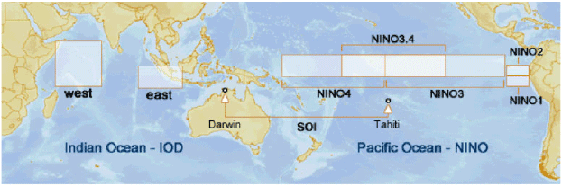
This summary reviews the southern hemisphere and equatorial climate patterns for winter 2018, with particular attention given to the Australasian and equatorial regions of the Pacific and Indian ocean basins (Fig. 1). From hereafter, the use of the term winter refers to the austral winter. The main sources of information for this report are analyses prepared by the Australian Bureau of Meteorology.
|
Unless otherwise stated, anomalies are calculated with respect to the period 1961–1990, and percentile-based analyses for the period from the start of the relevant dataset to 2018.
2 Pacific and Indian ocean basin climate indices
2.1 Southern Oscillation Index (SOI)
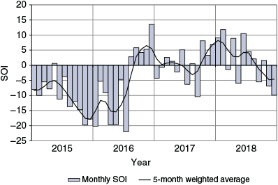
The Troup SOI1 for the period from October 2014 to September 2018 is shown in Fig. 2, also shown is a five-month weighted, moving average of the monthly SOI. Sustained negative values of the SOI below –7 are often indicative of El Niño episodes while persistently positive values of the SOI above +7 are typical of a La Niña episode.
|
The SOI values were negative and indicative of El Niño from the beginning of the period, only becoming positive in May 2016. Values were largely neutral for the rest of the period, with the brief presence of weak La-Niña-like values from late 2017 to early 2018. Over the winter of 2018, the SOI values were –5.5, 1.6 and –6.9 in June, July and August respectively, producing a seasonal average of –3.6.
2.2 Composite monthly ENSO Index (5VAR)
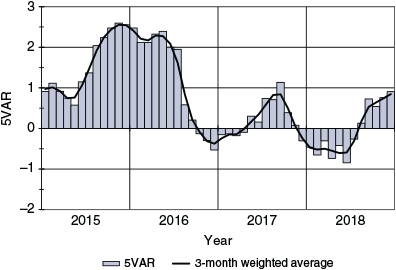
The El Niño–Southern Oscillation (ENSO) 5VAR Index (5VAR2) is a composite monthly ENSO index, calculated as the standardised amplitude of the first principal component of the monthly Darwin and Tahiti mean sea level pressure (MSLP) and monthly indices NINO3, NINO3.4 and NINO4 sea-surface temperatures3 (SSTs). Values of the 5VAR that are in excess of one standard deviation are typically associated with El Niño for positive values, whereas negative 5VAR values of a similar magnitude are indicative of La Niña. Fig. 3 displays the monthly 5VAR values along with their three-month average for the period from October 2014 to September 2018.
|
The 5VAR ENSO Index was also indicative of El Niño conditions from the start of the period to the middle of 2016. Values then stayed within the neutral range of being within one standard deviation of the climatology for the rest of the period. During the winter of 2018, the values were 0.73, 0.54 and 0.76 for June, July and August respectively, producing a seasonal average of 0.68.
The NINO3.4 index, which measures SSTs in the central Pacific Ocean within 5°N–5°S and 120–170°W, is used by the Australian Bureau of Meteorology to monitor ENSO; NINO3.4 is closely related to the Australian climate (Wang and Hendon 2007). NINO3.4 values were relatively stable over the winter of 2018. June 2018 continued the increasing trend that had been occurring for the first half of the year, with the value increasing from 0.21°C in May to 0.41°C in June. The values then stabilised, with 0.48°C and 0.35°C being recorded for July and August respectively.
All the indices suggested ENSO conditions were neutral over the winter of 2018, though there was the indication of a possible trend towards El-Niño-like conditions.
2.3 Indian Ocean Dipole (IOD)
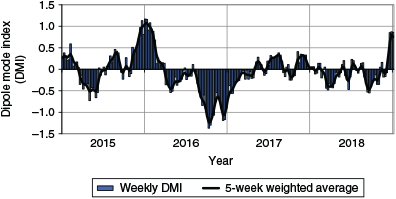
The IOD4 is the difference in ocean temperatures between the western node of the tropical Indian Ocean (centred on the equator) off the coast of Somalia and the eastern node off the coast of Sumatra. The IOD is said to be in a positive phase when values of the Dipole Mode Index (DMI) are greater than 0.4°C, neutral when the DMI is sustained between –0.4°C and 0.4°C and negative when DMI values are less than –0.4°C.
When under the influence of a strongly negative IOD phase warm maritime air is driven eastwards across the continent, leading to a negative IOD typically being associated with an increased chance of a wetter than average spring and/or winter for much of the continent. Negative IOD events often occur in conjunction with La Niña in the Pacific Ocean5, and positive IOD with El Niño. A relationship between ENSO and the IOD is acknowledged, but it is complicated and continues to be an active area of research. An IOD event of positive or negative phase may have a significant influence on rainfall regimes for Australia. Fig. 4 displays the weekly DMI along with its five-week average from October 2014 to September 2018.
|
The IOD index was neutral across most of 2018, with a weak tendency towards a negative phase. The winter of 2018 had a seasonal average of –0.25. This suggests the IOD had little influence on Australia over the winter of 2018. The end of the period demonstrates the IOD index quickly increased to positive values during September 2018.
3 Outgoing longwave radiation (OLR)
The OLR in the equatorial Pacific Ocean can be used as an indicator of enhanced or suppressed tropical convection. Increased positive OLR anomalies typify a regime of reduced convective activity, a reduction in cloudiness and, usually, rainfall. Conversely, negative OLR anomalies indicate enhanced convection, increased cloudiness and chances of increased rainfall. During La Niña (El Niño), decreased (increased) cloudiness can be seen near the International Date Line. Similarly, when Australia is under the influence of a negative IOD event, cloudiness is increased over the eastern Indian Ocean but decreased over the western Indian Ocean.
The Hovmöller diagram of OLR anomalies along the equator from April 2018 to September 2018 (Fig. 5) indicates a greater portion of positive OLR anomalies than negative anomalies over the winter. Cloudiness was generally below average from mid-June onwards. Averaged over a line along the International Date Line (7.5°S–7.5°N and 170°E–170°E), the monthly OLR anomaly was +1.1°C for June 2018, 0.3°C for July 2018 and 0.4°C for August 2018. Seasonal spatial patterns of OLR totals and anomalies across the Asia-Pacific region between 40°S and 40°N for winter 2018 are shown in Fig. 6.
|

|
Most of Australia experienced a negative OLR anomaly, although toward the southern and eastern coastlines, the anomaly tended to be positive. Outside of Australia, latitudes 0–20°S except for western Indonesia and Papua New Guinea recorded mostly positive anomalies and latitudes from 0–20°N recorded negative anomalies.
4 Madden-Julian Oscillation (MJO)
The MJO is a tropical convective wave anomaly which develops in the Indian Ocean and propagates eastwards into the Pacific Ocean (Madden and Julian, 1971, 1972, 1994). The MJO takes approximately 30–60 days to reach the western Pacific, with a frequency of 6–12 events per year (Donald et al. 2004). When the MJO is in an active phase, it is associated with areas of increased and decreased tropical convection, with effects on the southern hemisphere often weakening during early autumn, before transitioning to the northern hemisphere. A description of the real-time multivariate MJO (RMM) index and the associated phases can be found in Wheeler and Hendon (2004).
The phase-space diagram of the RMM for winter 2018 is shown in Fig. 7. The MJO started off strongly in June but weakened as it progressed eastwards over the Indian Ocean. The phase diagram indicates a short pulse over the Maritime Continent in the middle of June but otherwise it was weak for the rest of the winter.
|
5 Oceanic patterns
5.1 Sea surface temperatures (SSTs)
Fig. 8 shows the SST anomalies globally for winter 2018, relative to 1961–1990. Fig. 9 shows SST deciles, based on the full period of historical observations since 1900. Both figures demonstrate that SSTs were around average to above average across most of the globe. The SSTs were particularly warm in the northwest and the southern Pacific Ocean, the Arctic Ocean and the Atlantic Ocean off the coasts of North and South America, where the anomaly exceeded 1° above the 1961–1990 average. There was a region of significantly below-average SSTs in the North Atlantic Ocean off the southeast coast of Greenland. In the Australian region, SSTs were above average especially in the Coral Sea and the Tasman Sea.

|

|
In terms of globally-averaged values, monthly SSTs were the third-warmest on record for June and August (+0.56°C and +0.63°C respectively) and second-warmest for July (+0.63°C). Anomalies for the Australian region were not as strong with June being the eleventh-warmest on record (+0.47°C), July fourteenth-warmest on record (+0.44°C) and August thirteenth-warmest on record (+0.39°C).
5.2 Equatorial subsurface patterns
Fig. 10 demonstrates that subsurface waters were around average in the western equatorial Pacific tending above-average in the eastern equatorial Pacific. The shallow subsurface was particularly warm in June but cooled slightly over the winter, with the development of a cool anomaly in the eastern equatorial Pacific by August.
|
The 20°C isotherm depth is generally located close to the equatorial thermocline, which is the region of greatest temperature gradient with depth and is the boundary between the warm near-surface and cold deep-ocean waters. Therefore, measurements of the 20°C isotherm depth make a good proxy for the thermocline depth. Negative anomalies correspond to the 20°C isotherm being shallower than average and is indicative of cooling of subsurface temperatures. If the thermocline anomaly is positive the depth of the thermocline is deeper. A deeper thermocline results in less cold water available for upwelling, and therefore warming of surface temperatures.
Fig. 11 indicates the 20°C isotherm depth (and by proxy, the thermocline) was around average in the western equatorial Pacific becoming deeper towards the eastern equatorial Pacific. This positive anomaly was largest during June and July. A deeper thermocline for the eastern equatorial Pacific can be indicative of El Niño conditions but given the anomaly was short-lived and relatively weak, conditions should be considered neutral.

|
6 Sea ice
The Antarctic sea ice extent was 12.9, 15.7 and 17.4 million km2 in June, July and August 2018 respectively (Fetterer et al. 2002). This corresponds to a monthly sea ice concentration anomaly of –0.2 million km2 for June and July and an insignificant anomaly for August relative to the 1981–2000 average.
7 Atmospheric circulation
7.1 Southern Annular Mode (SAM)
Positive values of the SAM index during spring and early summer are associated with increased onshore flow in parts of eastern Australia, which typically increases the likelihood of above-average rainfall in much of New South Wales and parts of southern Australia, and below-average rainfall in western Tasmania (Wang and Hendon 2007). Conversely, negative SAM has roughly the inverse effect. SAM also has an impact on temperatures. In general, in areas where rainfall is increased, the temperature is decreased but where rainfall is decreased, the temperature is increased.
The SAM index was weak during the winter of 2018, commencing at a value of –0.012 in June, increasing to 0.377 in July and decreasing to –0.343 in August. This suggests the SAM was unlikely to have much influence on the weather of Australia over the winter of 2018.
7.2 Surface analyses
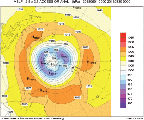
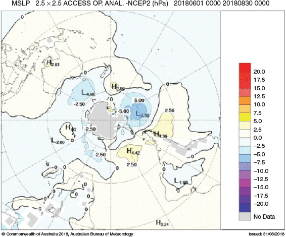
The MSLP pattern for winter 2018 is shown in Fig. 12, computed using data from the 0000 UTC daily analyses of the Bureau of Meteorology’s Australian Community Climate and Earth System Simulator (ACCESS) model6. MSLP anomalies are shown in Fig. 13, relative to the 1979–2000 climatology obtained from the National Center for Environmental Prediction (NCEP) II Reanalysis data (Kanamitsu et al. 2002). The MSLP anomaly field is not shown over areas of elevated topography (grey shading).
|
|
The seasonal MSLP analysis chart for winter 2018 (Fig. 13) was zonal in the southern hemisphere mid- to high-latitudes. The subtropical ridge was evident across the mid-latitudes with centres of high pressure being observed over Australia (reaching 1023.1 hPa), the eastern South Pacific (reaching 1023.3 hPa) and over southern Africa and off its east coast (reaching 1025.2 and 1024.0 hPa respectively). The polar low showed a minimum pressure of 978.3 hPa on the coast of Antarctica around 90°E.
MSLP was close to average across most of the globe with the exception of high-pressure anomalies around southern South America and low-pressure anomalies south of Australia and in the south-eastern Pacific Ocean.
7.3 Mid-tropospheric analyses
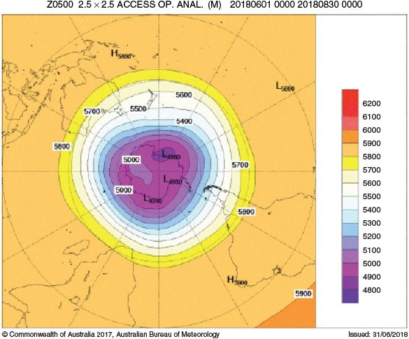
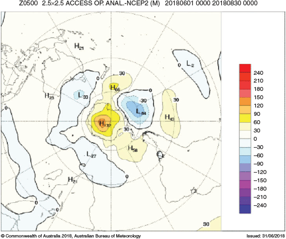
The 500 hPa geopotential height, an indicator of the steering of surface synoptic systems across the southern hemisphere, is shown for winter 2018 in Fig. 14 based on the NCEP2 reanalysis. The associated anomalies from 1979–2000 climatology are shown in Fig. 15.
|
|
Geopotential height is valuable for identifying and locating features like troughs and ridges which are the upper-level equivalents of surface low- and high-pressure systems respectively. An upper low was evident off the Antarctic coast around 180°E. A positive geopotential height anomaly was observed over Antarctica and a weaker negative anomaly was observed off the Antarctic coast around 120°E. Elsewhere across the southern hemisphere, geopotential height anomalies were close to average.
8 Winds
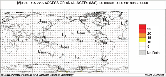
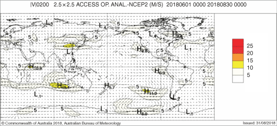
Figs 16 and 17 show winter 2018 low-level (850 hPa) and upper-level (200 hPa) wind anomalies respectively (winds computed from ACCESS and anomalies with respect to the 22-year 1979–2000 NCEP climatology). Isotach contours are at an interval of 5 m s−1.
|
|
The 850 hPa winds were close to average over Australia and globally. There was an area of stronger anomalies over the Antarctic coast between 170°W and 120°E corresponding to the high- and low-pressure anomalies discussed in Section 7.
At the 200 hPa level, wind anomalies were around average for most of the globe except for several regions. There was a couple of strong anomalies associated with anticyclonic patterns off the west coast of Australia and the southwest coast of South America. Additionally, there was also a strong anomaly associated with a cyclonic pattern over north-eastern China.
9 Australian region
9.1 Rainfall
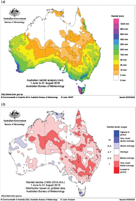
Rainfall for winter 2018 was below average across most of Australia (Fig. 18). The exceptions were towards the north coast of the Northern Territory, the Pilbara region of Western Australia and the west coast of Tasmania, where rainfall was above average, and around south-western Australia, where rainfall was around average. Averaged nationally, it was the fourteenth-driest winter in 119 years of records, with seasonal rainfall 32.9% below the 1961–1990 average (Table 1). In particular, New South Wales recorded its ninth-driest winter on record. The dry conditions over eastern Australia could be in part due to the weak El-Niño-like state observed over the season.
|

|
June rainfall was below average across central Australia, the Northern Tablelands in New South Wales and along the Queensland coast, above average around the Gascoyne region of Western Australia and mostly around average elsewhere.
July was a drier month, with rainfall below average across most of the southern half of Australia, especially in New South Wales which recorded its fifth-driest July on record with some central parts of the state experiencing their driest July on record. Tasmania was an exception, recording significantly above-average rainfall resulting in its eighth-wettest July on record.
August saw a reversal of the trend, with rainfall being above average across the southwest of Australia and the northern parts of Northern Territory. Rainfall was mostly average to above average elsewhere, being particularly above average in southern New South Wales and the northern Queensland coast. Parts of the Arnhem region in Northern Territory and the Lower Eyre Peninsula in South Australia had their wettest August on record.
9.2 Rainfall deficiencies
The first half of 2018 resulted in rainfall deficiencies over large parts of New South Wales along with border regions in the adjacent states (Fig. 19). The winter of 2018 also saw below-average rainfall across these areas, worsening these deficiencies (commencing from January 2018) and resulting in widespread severe deficiencies across most of New South Wales, with some areas in western and central New South Wales experiencing lowest on record deficiencies as well (Table 2). Conversely, rainfall deficiencies along the south-western coast of Western Australia, which included severe and lowest on record deficiencies, were eased. The below-average seasonal rainfall for winter also resulted in severe five-month rainfall deficiencies over southern Northern Territory and south-western and northern parts of Queensland.

|

|
9.3 Temperature
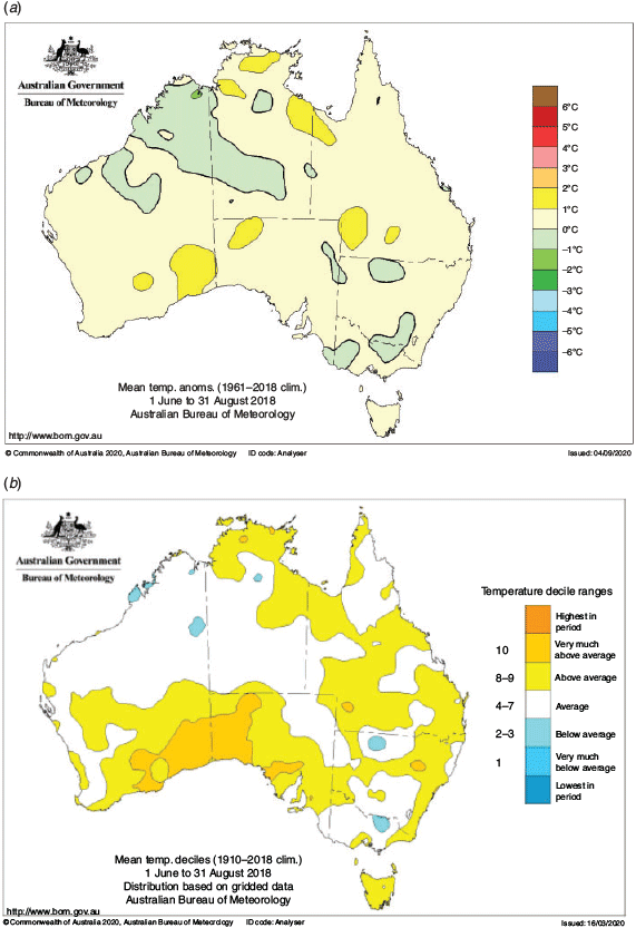
The mean temperature for winter 2018 was above average across southern Western Australia and South Australia, Tasmania, inland parts of Queensland, northern parts of Northern Territory and along parts of the eastern coastline (Fig. 20). Elsewhere, they were mostly around average. The nationally averaged mean temperature anomaly was +0.59°C above the 1961–1990 average, the 15th-highest in a record of 109 years.
|
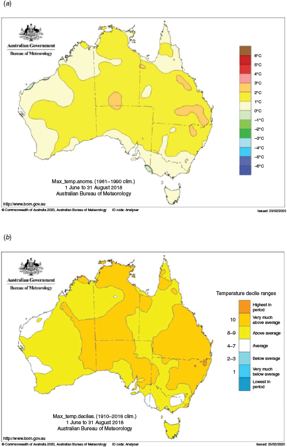
The positive mean temperature was mostly driven by above-average maximum temperatures with almost the entirety of the continent experiencing above-average maximum temperatures. The nationally averaged maximum temperature anomaly was +1.29°C, the fifth-highest on record (Table 3). Most of the Northern Territory, South Australia, Queensland and New South Wales had mean maximum temperatures in decile 10.

|
Although each of the months was warmer than the average in terms of maximum temperatures, July was significantly more anomalous with an anomaly of +2.32°C, making it the second-warmest July on record. Most of the country had mean maximum temperatures in decile 10 with Queensland, New South Wales, South Australia, Western Australia and the Northern Territory observing temperatures among the four warmest on record (Fig. 21). June saw the daytime warmth focused on the northern half of the mainland while in August, the warmth was towards the Queensland coast.
|
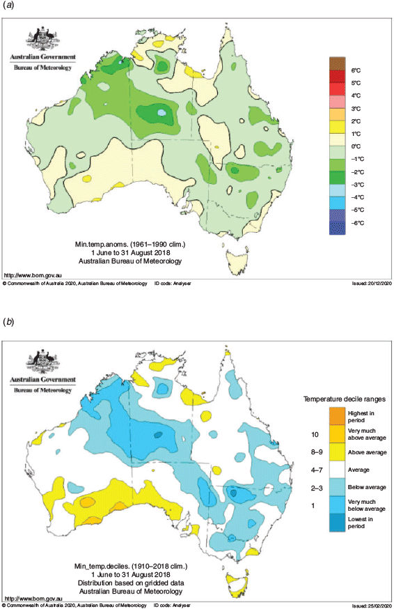
In contrast, the mean minimum temperature was below average. The anomaly was –0.13°C, the equal 51st coolest on record (Table 4). New South Wales, central Australia and north-eastern Western Australia were the regions where the cool anomaly was the greatest (Fig. 22). Temporally, the cool anomaly was most pronounced in August where parts of the Pilbara, Kimberley and North Interior districts of Western Australia along with south-western Northern Territory, experienced minimum temperatures in decile 1 with some areas in these parts also being the lowest on record (Table 5). The coastal regions along the Great Australian Bight experienced a warm anomaly while the rest of the country was mostly around average.

|
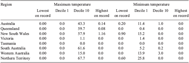
|
|
10 Southern hemisphere
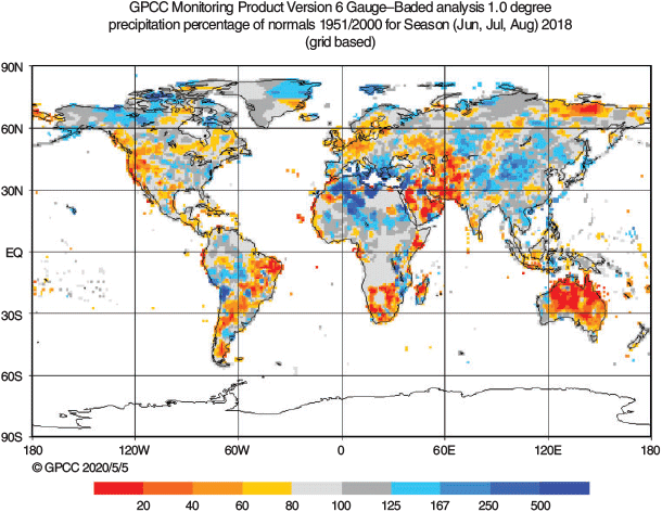
Fig. 23 depicts the global rainfall as a percentage of the climatological average from 1951 to 2000, for June to August 2018. The map is a product of the Global Precipitation Climatology Centre (GPCC) gauge-based analysis data. For the hemisphere, the driest region for the period was over central and northern Australia. Rainfall was also notably below average over the southern and eastern parts of South America and southern Africa.
|
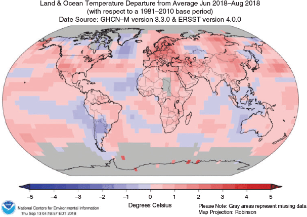
Fig. 24 shows the global land and surface temperature anomaly with respect to the climatological period of 1981–2010, for June to August 2018. The map is a product of land surface temperatures from the Global Historical Climatology Network-Monthly (GHCN-M) dataset and SSTs from the Extended Reconstructed Sea Surface Temperature (ERSST) dataset. For the hemisphere, the area-averaged temperature was the equal second-highest in the GISS Surface Temperature Analysis dataset, the sixth-highest in the NOAA Global Surface Temperature dataset and the tenth-highest in the Hadley Centre/Climate Research Unit dataset. Warmer than average temperatures were observed over Brazil, Africa and Australia. Lower than average temperatures were observed over southern South America and off its western coast, off the coast of western Australia and around the Maritime Continent.
The dry conditions in Argentina were following the country coming out of its worst drought in at least 50 years with an estimated economic loss of around US$6 billion (Herring et al. 2020; Stella et al. 2019).
|
Conflicts of interest
The authors declare that they have no conflicts of interest.
Acknowledgements
I would like to acknowledge the help and support of my colleagues at the Bureau in assisting me with this paper, in particular Skie Tobin. This research did not receive any specific funding.
References
Donald, A., Meinke, H., Power, B., Wheeler, M., and Ribbe, J. (2004). Forecasting with the Madden-Julian Oscillation and the applications for risk management. In ‘International Crop Science Congress (ICSC 2004): New Directions for a Diverse Planet, 26 September–1 October 2004, Brisbane, Australia’. Available at http://www.cropscience.org.au/icsc2004/poster/2/6/1362_donalda.htm.Fetterer, F., Knowles, K., Meier, W., and Savoie, M. (2002). Sea Ice Index, updated daily. [Monthly Sea Ice Concentration and Anomalies]. Boulder, Colorado USA: National Snow and Ice Data Center
Herring, S. C., Christidis, N., Hoell, A., Hoerling, M. P., and Stott, P. A. (2020). Explaining Extreme Events of 2018 from a Climate Perspective. Bull. Amer. Meteor. Soc. 101, 35–41.
| Explaining Extreme Events of 2018 from a Climate Perspective.Crossref | GoogleScholarGoogle Scholar |
Kanamitsu, M., Ebisuzaki, W., Woollen, J., Yang, S.-K., Hnilo, J. J., Fiorino, M., and Potter, G. L. (2002). NCEP-DOE AMIPII Reanalysis (R-2). Bull. Amer. Meteor. Soc. 83, 1631–1643.
| NCEP-DOE AMIPII Reanalysis (R-2).Crossref | GoogleScholarGoogle Scholar |
Kuleshov, Y., Qi, L., Fawcett, R., and Jones, D. (2009). Improving preparedness to natural hazards: Tropical cyclone prediction for the Southern Hemisphere. Adv. Geosci. 12, 127–143.
| Improving preparedness to natural hazards: Tropical cyclone prediction for the Southern Hemisphere.Crossref | GoogleScholarGoogle Scholar |
Madden, R. A., and Julian, P. R. (1971). Detection of a 40-50 day oscillation in the zonal wind in the tropical Pacific. J. Atmos. Sci. 28, 702–708.
| Detection of a 40-50 day oscillation in the zonal wind in the tropical Pacific.Crossref | GoogleScholarGoogle Scholar |
Madden, R. A., and Julian, P. R. (1972). Description of global-scale circulation cells in the tropics with a 40-50 day period. J. Atmos. Sci. 29, 1109–11023.
| Description of global-scale circulation cells in the tropics with a 40-50 day period.Crossref | GoogleScholarGoogle Scholar |
Madden, R. A., and Julian, P. R. (1994). Observations of the 40-50 day tropical oscillation: a review. Mon. Wea. Rev. 122, 814–837.
| Observations of the 40-50 day tropical oscillation: a review.Crossref | GoogleScholarGoogle Scholar |
Stella, J., Aldeco, L., Campos Díaz, D., and Misevicius, N. (2019). Southern South America [in “State of the Climate in 2018”]. Bull. Amer. Meteor. Soc. 100, S205–S207.
| Southern South America [in “State of the Climate in 2018”].Crossref | GoogleScholarGoogle Scholar |
Troup, A. (1965). The Southern Oscillation. Quart. J. Roy. Meteor. Soc. 91, 490–506.
| The Southern Oscillation.Crossref | GoogleScholarGoogle Scholar |
Wang, G., and Hendon, H. (2007). Sensitivity of Australian rainfall to inter-El Niño variations. J. Climate 20, 4211–4226.
| Sensitivity of Australian rainfall to inter-El Niño variations.Crossref | GoogleScholarGoogle Scholar |
Wheeler, M., and Hendon, H. (2004). An All-Season Real-Time Multivariate MJO Index: Development of an Index for Monitoring and Prediction. Mon. Wea. Rev. 132, 1917–1932.
| An All-Season Real-Time Multivariate MJO Index: Development of an Index for Monitoring and Prediction.Crossref | GoogleScholarGoogle Scholar |
1 The Troup Southern Oscillation Index (Troup, 1965) used in this article is ten times the standardised monthly anomaly of the difference in mean sea level pressure (MSLP) between Tahiti and Darwin. The calculation is based on a sixty-year climatology (1933–1992), with records commencing in 1876. The Darwin MSLP is provided by the Bureau of Meteorology, and the Tahiti MSLP is provided by Météo France inter-regional direction for French Polynesia.
2 ENSO 5VAR was developed by the Bureau of Meteorology and described by Kuleshov et al. (2009). The principal component analysis and standardisation of this ENSO index are performed over the period 1950–1999.
3 SST indices obtained from ftp://ftp.cpc.ncep.noaa.gov/wd52dg/data/indices/sstoi.indices.
4 http://www.bom.gov.au/climate/iod/
5 http://www.bom.gov.au/climate/iod/#tabs=Pacific-Ocean-interaction
6 For more information on the Bureau of Meteorology’s ACCESS model, see http://www.bom.gov.au/nwp/doc/access/NWPData.shtml
7 A subset of the full temperature network is used to calculate the spatial averages and rankings shown in Table 3 (maximum temperature), Table 4 (minimum temperature) and Table 5. This dataset is known as ACORN-SAT (see http://www.bom.gov.au/climate/change/acorn-sat/ for details). These averages are available from 1910 to the present. As the anomaly averages in the tables are only retained to two decimal places, tied rankings are possible.