Potential field interpretation and modelling in the deep-water Otway Basin
Yvette H. Poudjom Djomani A * and Merrie-Ellen Gunning AA Geoscience Australia, Canberra, ACT, Australia.
The APPEA Journal 62 S487-S491 https://doi.org/10.1071/AJ21209
Accepted: 10 March 2022 Published: 13 May 2022
© 2022 The Author(s) (or their employer(s)). Published by CSIRO Publishing on behalf of APPEA. This is an open access article distributed under the Creative Commons Attribution 4.0 International License (CC BY).
Abstract
The NW–SE trending Otway Basin is a well-established hydrocarbon province with onshore and shallow-water offshore discoveries. However, the deep-water offshore is underexplored due to the sparsity of data in the past. New 2D seismic, gravity and magnetic data, acquired during the 2020 Otway Basin Seismic Program, were combined with legacy seismic data to improve the understanding of this part of the basin. The new data have been processed and integrated with existing open-file data to derive Moho and lithosphere–asthenosphere boundary surfaces. Additional wavelength filtering of the newly acquired magnetic and gravity data, using constraints from seismic data, provides valuable information on the geometry and the spatial extent of igneous rocks in the deep-water basin. While extrusive igneous rocks and related intrusive rocks in the Otway Basin can be inferred from seismic reflection data, the new magnetic and gravity data provide additional constraints that help to map their distribution across the basin.
Keywords: deep-water, gravity, high-pass filter, hydrocarbon prospectivity, igneous rocks, magnetic modelling, magnetics, Otway Basin, tilt angle, wells.
Introduction
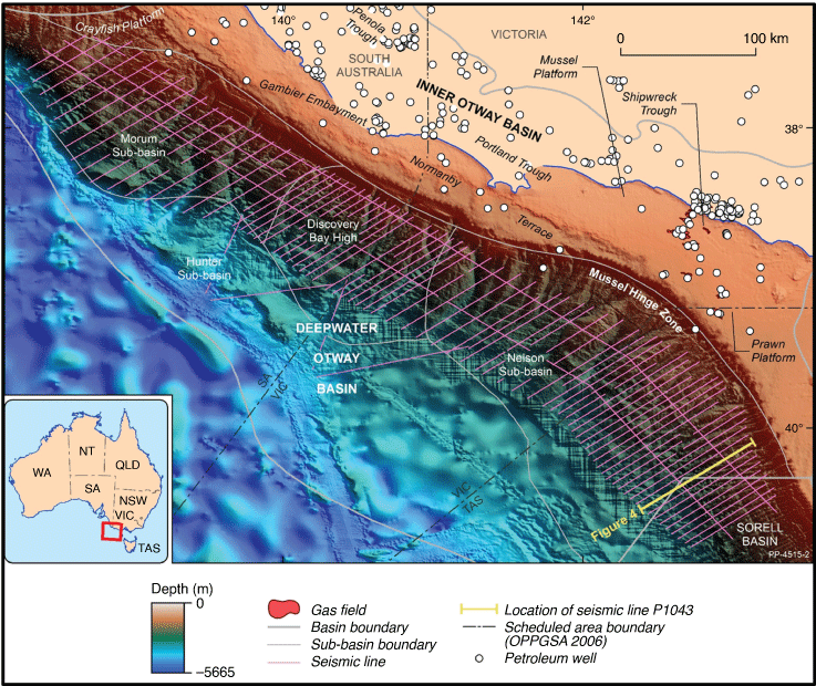
The Otway Basin is a broadly NW–SE trending basin and is part of a rift system that developed along Australia’s southern margin during the Late Jurassic to Late Cretaceous (Moore et al. 2000). Unlike the onshore and shallow offshore parts, with hydrocarbon discoveries, the deep-water part is underexplored with sparse 2D seismic lines and no wells. The 2020 Otway Basin Seismic Program (OBSP) (Karvelas et al. 2021; Fig. 1) acquired 8200 line-km of 2D seismic, gravity and magnetic data, and had the key objective of improving the quantity and quality of data over the deep-water parts of the offshore basin for regional interpretation and basin analysis.
Geoscience Australia has examined the deep-water Otway Basin as a potential area for hydrocarbon exploration. The work involves an integrated approach to build a better understanding of the deep-water part of the basin, its prospectivity and the identification of new hydrocarbon plays.
As part of this basin study, the newly acquired magnetic and gravity data have been processed and integrated with existing open-file data. Moho and lithosphere surfaces have been derived from the data. Comparisons of basement interpretations derived from the potential field data, including major structures, with those derived from the seismic data (Nicholson et al. 2022) have been made. The data have also been used to guide the mapping of igneous rocks and their extent using seismic data. The outcomes of this work are expected to have a significant impact on updated petroleum systems modelling results later in the study.
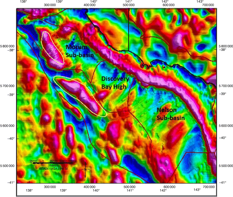
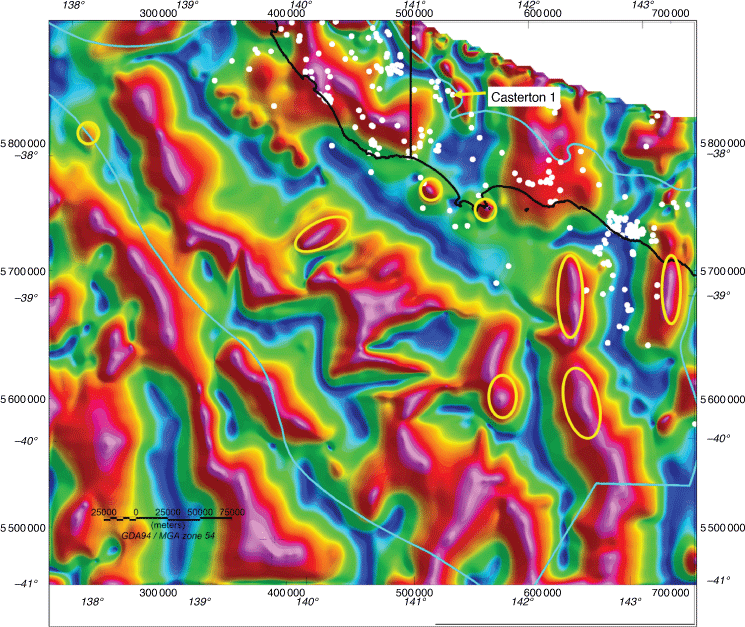
Potential field data is a cost-effective means to providing additional constraints on important characteristics of sedimentary basins, including: sediment thickness, fault architecture, distribution of igneous rocks and basement composition. Tilt-angle filtering of magnetic data (Fig. 2) shows narrow subtle anomalies that correlate with igneous rocks in the onshore Otway Basin. This correlation suggests that the tilt angle of magnetic data may help map the unexposed igneous features offshore. Positive gravity anomalies, as seen on the high-pass 150 km filtered data (Fig. 3), correlate well with basement highs identified through seismic interpretation in the outer margins of the basin. This correlation suggests that the enhanced gravity data is a useful tool to map structural elements within the deep-water area.

|
OB2020 potential field data
As part of the OBSP survey, gravity and magnetic data were acquired along all 2D seismic lines (Fig. 1) by PartnerPlast on behalf of SeaBird Exploration for Schlumberger Australia Pty Ltd. These data were processed to produce the potential field final grids provided with the seismic survey, both of which are available from www.nopims.gov.au under ENO0603786. The magnetic data were merged with public-domain survey data (Meyer et al. 2017) to produce seamless magnetic maps of the combined onshore and offshore parts of the Otway Basin. Similarly, the gravity data were merged with public-domain satellite data (Sandwell and Smith 2009) to produce gravity images. The integration of data from the nearshore to the deep-water basin is crucial as resolution of interpretation and well control inboard are necessary constraining factors for basin interpretation.
Enhancement processing
The merged gravity and magnetic datasets were further enhanced to better highlight some buried features. Various filters were applied, including tilt angle, first vertical derivatives, upward continuation, analytic signal, high-pass and low-pass filters. Some of these filters and the resultant grid interpretation are described below.
Tilt angle of magnetic data
The tilt angle is a quantity derived from the ratio of vertical to total horizontal derivative and is defined by Miller and Singh (1994) as:

The tilt angle tends to normalise anomaly amplitudes and is positive over vertically sided anomaly sources. Therefore, positive tilt angles can be used to help identify source bodies irrespective of magnetisation direction (Morse 2010). Tilt angle for the merged magnetic grid of the Otway Basin is shown in Fig. 2. The image shows some narrow subtle magnetic highs that correlate with the occurrence of igneous rocks identified in wells in the onshore Otway Basin. For example, 25 m of igneous rocks were intersected in Casterton-1 at 2400 m depth. Little can be said about this correlation in the offshore due to the absence of exploration wells. These positive magnetic anomalies in the inshore may not have been drilled deep enough to penetrate any igneous rocks. A similar correlation between the magnetic anomalies and the occurrence of igneous rocks in wells was made in the Browse Basin on Australia’s North West Shelf (Hackney et al. 2015). The correlation between the magnetic tilt anomalies and the igneous rocks onshore suggests that this magnetic filter may be used to map the distribution of such rocks in the deep-water Otway Basin.
High-pass filtering of gravity data
Fig. 3 shows a 150 km high-pass filter of the combined gravity data over the Otway Basin. This filter emphasises anomalies with wavelengths less than 150 km and is useful to map the Continent–Ocean Boundary (COB) and areas of basement high or exhumed mantle, within the basin. It should be noted that the new gravity data has higher resolution than the satellite-derived data. Combining the two datasets is useful for a regional study, but there is a risk of losing some valuable information contained in the higher-resolution data.
The interpretation of seismic lines has identified some basement highs in the outer margins of the basin (Nicholson et al. 2022). These highs correlate well with the positive gravity anomalies as seen on the high-pass 150 km filtered data. This correlation suggests that the enhanced gravity data is a good tool to use for mapping major structural elements spatially across the deep-water Otway Basin and is valuable in resolving structural trends across the seismic coverage.
Magnetic data modelling
Seismic line P1043 (OBSP) at the southeast end of the Otway Basin (Fig. 1) was selected to test the identification of the extent of igneous rocks. In this area, Schenk et al. (2021) identified some isolated igneous intrusions, less than 5 km in width, in the Upper Cretaceous sequence. Using ModelVision Pro, the magnetic anomalies along this line are broad and suggest deep-seated bodies at depths between 12 and 19 km. Modelling is progressing on seismic lines in other areas of the basin to enable more accurate mapping of the location and extent of igneous features.
Results and conclusions
The new gravity and magnetic data, acquired during the 2020 Otway Basin Seismic Program were processed and integrated with existing open-file data to produce a merged dataset for the onshore and offshore Otway Basin. Enhancement processing of the data provides valuable information on basement structure and the possible distribution of igneous rocks. For example, tilt angle of the magnetic data shows narrow subtle magnetic highs that correlate with igneous rocks identified in wells in the onshore Otway Basin. This correlation suggests that the tilt filter grid can be used to map the distribution of such rocks in the deep-water areas. The newly acquired seismic data reveal basement highs that correlate well with the positive gravity anomalies evident in the high-pass 150 km filtered data. This correlation suggests that the enhanced gravity data is a good tool to use for mapping structural elements within the deep-water areas. Magnetic data modelling is in progress along the seismic lines to help locate potential intrusive rocks.
Data availability
All the original seismic, gravity and magnetic data from the 2020 OBSP used in this study are available for download from the National Offshore Petroleum Information System (www.nopims.gov.au) under ENO0603786.
Conflicts of interest
All authors confirm there are no conflicts of interest.
Declaration of funding
No funding from external organisations was received for this research.
Acknowledgements
The authors thank Dr Ron Hackney and Mr George Bernardel for their constructive review. This abstract is published with the permission of the CEO, Geoscience Australia.
References
Hackney R, Romeyn R, Orlov C (2015) Interpretation and modelling of new Browse Basin airborne magnetic data for igneous rocks and basement. ASEG Extended Abstracts 2015, 1–4.| Interpretation and modelling of new Browse Basin airborne magnetic data for igneous rocks and basement.Crossref | GoogleScholarGoogle Scholar |
Karvelas A, West T, Nicholson C, Abbott S, Bernardel G, Mitchell C, Nguyen D, Gunning M-E, Borissova I, Schenk O (2021) New insights into the deep-water Otway Basin – Part 2. Tectonostratigraphic framework revealed by new seismic data. The APPEA Journal 61, 657–664.
| New insights into the deep-water Otway Basin – Part 2. Tectonostratigraphic framework revealed by new seismic data.Crossref | GoogleScholarGoogle Scholar |
Meyer B, Saltus R, Chulliat A (2017) EMAG2: Earth Magnetic Anomaly Grid (2-arcminute resolution) Version 3. NOAA. (National Centres for Environmental Information)
| Crossref |
Miller HG, Singh V (1994) Potential field tilt—a new concept for location of potential field sources. Journal of Applied Geophysics 32, 213–217.
| Potential field tilt—a new concept for location of potential field sources.Crossref | GoogleScholarGoogle Scholar |
Moore AMG, Stagg HMJ, Norvick MS (2000) Deep-water Otway Basin: a new assessment of the tectonics and hydrocarbon prospectivity. The APPEA Journal 40, 66–84.
| Deep-water Otway Basin: a new assessment of the tectonics and hydrocarbon prospectivity.Crossref | GoogleScholarGoogle Scholar |
Morse M (2010) Potential field methods prove effective for continental margin studies. AusGeo News 98, 1–4. Available at https://www.ga.gov.au/ausgeonews/ausgeonews201006/geology.jsp
Nicholson C, Abbott S, Bernadel G, Gunning ME (2022) Stratigraphic and structural architecture of the Upper Cretaceous in the deep-water Otway Basin – implications for frontier hydrocarbon prospectivity. The APPEA Journal 62, S467–S473.
| Stratigraphic and structural architecture of the Upper Cretaceous in the deep-water Otway Basin – implications for frontier hydrocarbon prospectivity.Crossref | GoogleScholarGoogle Scholar |
Sandwell DT, Smith WHF (2009) Global marine gravity from re-tracked Geosat and ERS-1 altimetry: ridge segmentation versus spreading rate. Journal of Geophysical Research: Solid Earth 114, B01411
| Global marine gravity from re-tracked Geosat and ERS-1 altimetry: ridge segmentation versus spreading rate.Crossref | GoogleScholarGoogle Scholar |
Schenk O, Karvelas A, West T, Kornpihl D (2021) Otway Basin Regional Study report. Available at https://www.ga.gov.au/nopims/releases/otway-basin-regional-study-report

Yvette Poudjom Djomani is a Geophysicist with over 25 years of experience. She joined the Mineral System Branch of Geoscience Australia in 2016 working on magnetic, radiometric and gravity survey data quality control and assurance. Since July 2021, she has been working in the Offshore Energy System Branch on potential field data processing and enhancement, and integration with seismic data to help map the distribution of igneous rocks in the offshore Otway Basin. Yvette completed a Bachelor Degree in Science at the University of Yaoundé (Cameroon), a PhD in Geophysics at the University of Paris XI (France) and an MBA from the Australian Institute of Business (Adelaide). She has worked in academia, industry sector and government agencies. Yvette is the current Treasurer of the Federal Executive of the Australian Society of Exploration Geophysicists (ASEG). She is also the Chair of the Gender Equity Network at Geoscience Australia. |

Merrie-Ellen Gunning has over 20 years of experience in the Oil and Gas industry where she has performed a diverse range of roles from strategic planning, business development and operations management, to technical roles specialising in Geophysics and Exploration. Added to this is 5 years of experience in the aluminium industry across the value chain from extraction, mining bauxite and nepheline, through refining alumina to smelting. In addition to her extensive knowledge of industry in Australia, her experience has included postings to Indonesia, Norway, the US, Russia and Singapore, and overseeing operations across the world. She has an MBA from Melbourne Business School and a Bachelor of Applied Science in Geology. Merrie-Ellen joined Geoscience Australia in August 2015 and has worked on a wide range of prospectivity and CO2 storage projects, leading the Energy Systems Branch throughout 2017 and is currently Director of Offshore Energy Systems. |


