

Seismic, petrophysical and petrological constraints on the alteration of igneous rocks in the Northern Carnarvon Basin, Western Australia: implications for petroleum exploration and drilling operations
Michael S. Curtis A * , Simon P. Holford A , Mark A. Bunch A and Nick J. Schofield BA Australian School of Petroleum and Energy Resources, University of Adelaide, North Terrace, Adelaide, 5000, Australia.
B Department of Geology and Geophysics, School of Geosciences, University of Aberdeen, Aberdeen, AB24 3FX, Scotland.
The APPEA Journal 62(1) 196-222 https://doi.org/10.1071/AJ21172
Submitted: 08 December 2021 Accepted: 20 January 2022 Published: 13 May 2022
© 2022 The Author(s) (or their employer(s)). Published by CSIRO Publishing on behalf of APPEA.
Abstract
The Northern Carnarvon Basin (NCB) hosts an extensive record of Jurassic–Cretaceous rift-related igneous activity, manifested by a >45 000 km2 intrusive complex and series of volcanic centres constrained by seismic mapping. However, there are relatively few well penetrations of these igneous rocks (<1% of ~1500 exploration wells) in comparison to other basins that witness extensive magmatism, and thus, their lithological and petrophysical characteristics are poorly understood. Here, we describe the properties of igneous rocks encountered in nine petroleum exploration wells and scientific boreholes in the NCB and evaluate their impacts on exploration and development issues. Igneous rocks in the NCB are characterised by pervasive alteration, with ramifications for seismic imaging and drilling. For example, low acoustic velocities in mafic lavas altered to clays in Toro-1 were mistaken for overpressure, whilst intrusive rocks in Palta-1 were initially unrecorded and only recognised due to subsequent post-drilling thermal history analysis. The alteration of mafic igneous rocks to clays reduces acoustic impedance contrasts relative to sedimentary host rocks, making their identification prior to drilling more challenging. Whilst the preferential emplacement of intrusive rocks in Triassic strata deeper than reservoir targets is primarily responsible for the paucity of well penetrations, our findings of extensive alteration of igneous rocks in the NCB suggests that additional wells may intersect as yet unrecognised intrusive or extrusive sequences.
Keywords: alteration, ash, Carnarvon, development, dyke, exploration, fluid, hazard, igneous, intrusion, intrusive, overpressure, petroleum, petrophysics, seismic, sill, swelling clay, tuff, volcanic, volcano, well logs.
Introduction
The Northern Carnarvon Basin (NCB), part of the Australia’s North West Shelf, is one of a series of basins that records the Jurassic rifting and Early Cretaceous breakup of Greater India from the Australian continent (Fig. 1). Rifting was accompanied by extensive magmatism: a network of sills and dykes with spatial extent of 45 000 km2 was emplaced in the crust of the Exmouth Plateau and Exmouth Sub-basin from the Kimmeridgian to the Valanginian (Symonds et al. 1998; Magee et al. 2013a; Magee et al. 2016; Magee et al. 2017), while volcanoes erupted in the Exmouth Sub-basin in the Tithonian (Black et al. 2017) (Fig. 1).

|
As the NCB is Australia’s premier hydrocarbon province, it is of fundamental importance to understand the impact of rift-related magmatic activity on petroleum systems. Although many studies have focussed on their seismic expression (e.g. Symonds et al. 1998; Müller et al. 2002; Holford et al. 2013; Magee et al. 2013a, 2013b, 2018; McClay et al. 2013; Rohrman 2013; O’Halloran et al. 2019; Magee and Jackson 2020; Mark et al. 2020), very few have considered the nature and origin of igneous rocks that have been penetrated by drilling in the NCB. Understanding igneous lithologies and issues related to the intersection of igneous rocks is crucial for a comprehensive appreciation of magmatic impacts on both petroleum systems and drilling. For example, igneous intrusions can overmature source rocks at a local scale and compartmentalise hydrocarbon reservoirs (Holford et al. 2013; Senger et al. 2017); transgressive intrusions can act as conduits for overpressure, risking blowout if penetrated accidentally (Schofield et al. 2020); whilst volcanic ash altered to bentonite clay can also present drilling difficulties (Watson et al. 2020).
Only 12 of ~1500 (<1%) exploration wells in the NCB have penetrated igneous rocks (Fig. 1). Proportionally, this is far lower than on rifted volcanic margins elsewhere. For example, ~55% of exploration wells intersect igneous rocks in the Bass Basin, offshore southern Australia (Watson et al. 2019). Here, we analyse data from seven wells and two scientific boreholes penetrating igneous rocks in the NCB and document the impact of igneous rocks on petroleum exploration. Intrusive and extrusive igneous rocks are penetrated in the Exmouth Plateau and Exmouth Sub-basin. In all cases, these igneous rocks have been significantly altered. We propose that this alteration, which is difficult to recognise both prior to drilling and during logging, along with the fact that most intrusions were emplaced deeper than major hydrocarbon targets, are possible reasons for such few penetrations of igneous rock in the NCB.
Geological setting
The NCB was initiated in the Early Triassic and records the Jurassic rifting and Early Cretaceous breakup of Greater India from Australia. The deep marine Locker Shale and deltaic rocks of the Mungaroo Formation were deposited in the Early and Middle Triassic (Kopsen and McGann 1985; Adamson et al. 2013). Rift basins initiated along the inboard margin during the Jurassic: the Exmouth, Barrow and Dampier sub-basins. These sub-basins were filled by gravity flows of the Brigadier Formation followed by the deep marine Murat and Athol formations (Hocking 1992). Following the breakup on the Argo Margin in the Callovian (Jablonski 1997; Tindale et al. 1998), the Dingo Claystone was deposited in the rift basins (Hocking 1992). In the Exmouth Plateau, Jurassic deposition was limited (Exon et al. 1992; Tindale et al. 1998; Reeve et al. 2016). Rifting recommenced in the Early Cretaceous. Uplift at this time on the Australian continent, and on the Greater Indian continent to the west, fed the Barrow Delta (Reeve et al. 2016) which deposited the Lower and Upper Barrow groups across the Exmouth and Barrow sub-basins and northwards onto the Exmouth Plateau (Reeve et al. 2016; Paumard et al. 2018). Rifting culminated in the final breakup of Greater India from Australia in the Early Cretaceous along the Cuvier and Gascoyne margins, and is represented by two regional unconformities: 1) the Valanginian or ‘KV’ Unconformity and 2) the Intra-Hauterivian Unconformity (Reeve et al. 2022). Following breakup, the deep marine Muderong Formation, Windalia Radiolarite and Gearle Siltstone were deposited across the region (Felton et al. 1992) until an inversion in the Cretaceous–Cenozoic caused regional uplift (Densley et al. 2000). The NCB has since experienced tectonically stable conditions, with carbonate deposition until the present day (Quilty 1977).
The pre-breakup magmatic system is focussed in the central Exmouth Sub-basin and the western Exmouth Plateau (Fig. 1). It is comprised of an interconnected system of igneous intrusions, covering ~45 000 km2 (Symonds et al. 1998), and two Tithonian volcanic centres: the Toro Volcanic Complex (TVC) (Black et al. 2017) and Mt Aneto (Curtis et al. 2021). Intrusive rocks in the Exmouth Plateau and central Exmouth Sub-basin were emplaced during the Late Jurassic and Early Cretaceous (Symonds et al. 1998; Magee et al. 2013a; Magee et al. 2016; Magee et al. 2017). In the southern-most Exmouth Sub-basin, close to the Herdsman-1 well, intrusions appear to be peneplaned by an Aptian-aged unconformity, here constraining its age to older than 113 Ma (McClay et al. 2013; Mark et al. 2020).
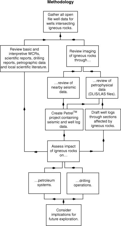
Data and methods
Wells intersecting igneous rocks within the Carnarvon Basin were identified (Fig. 2): Toro-1, which intersected a volcano; Stybarrow-2, Enfield-3, Enfield-4 and Ocean Drilling Program (ODP) 763 B and C, which intersected ashfall deposits; and Palta-1, Yardie East-1 and Chester-1, which intersected intrusive sills and dykes. Data for each well was compiled from the National Offshore Petroleum Information Management System (NOPIMS) and the West Australian Petroleum Information Management System (WAPIMS) (Fig. 2). This included Well Completion Reports (WCRs), petrophysical logs, scientific and government reports, petrographic data and core photos. Local open file 2D and 3D seismic reflection and refraction data, and associated interpretation reports, were also accessed. A search of scientific literature focussing on the areas in which the wells were drilled was completed.
|
For each well, the impact of the intersected igneous rocks on petroleum exploration was reviewed (Fig. 2). In some wells, the impact was most prominent on the target petroleum system (e.g. Yardie East-1), whereas in others, drilling operations were more strongly affected (e.g. Toro-1).
Wells that intersect extrusive igneous rocks
Of the nine wells and boreholes in this study, five penetrate extrusive igneous rocks. Toro-1 penetrates a volcano in the Exmouth Sub-basin (Fig. 1). Volcanic ashfall deposits, possibly sourced from the volcano intersected at Toro-1, are penetrated in Stybarrow-2, Enfield-3 and Enfield-4 in the Exmouth Sub-basin and in two boreholes at ODP site 763 in the Exmouth Plateau (Fig. 1).
Toro-1: highly altered basaltic lava flows
Geological setting and nature of penetrated igneous rocks
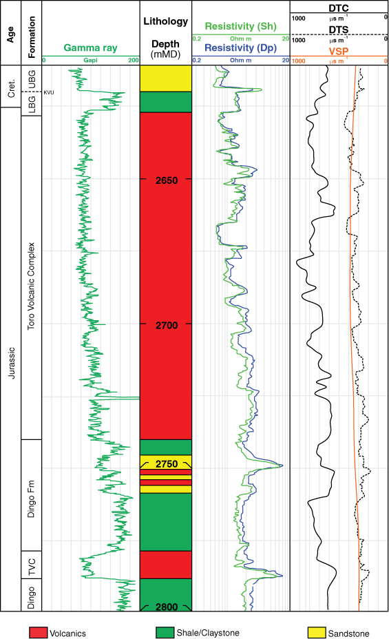
Toro-1 was drilled by Woodside Energy Ltd. in 2014 in the western Exmouth Sub-basin (Fig. 1) and discovered gas in a rotated fault block within Triassic Mungaroo Formation sandstone reservoirs (Sturrock 2014; Taylor 2015). Toro-1 intersected the western flank of the northern-most volcanic edifice of the TVC between 2627 and 2788 mRT (Fig. 3). The TVC is a Tithonian-aged, syn-rift volcanic complex, which extends north–south over a distance of ~30 km (Black et al. 2017). The volcanic rocks penetrated by the well conformably overlie the Tithonian Dingo Claystone, with shales from this stratigraphic unit increasingly interbedded with volcanic rocks beneath the main edifice. At Toro-1, the flank of the volcano is conformably overlain by the Tithonian–Berriasian Macedon Mudstone of the Lower Barrow Group beneath the KV Unconformity (Fig. 3).

|
Intersected volcanic rocks are heavily altered, are mostly comprised of clay and are described by Woodside as ‘grey, mottled, soft to firm and consist of fine-grained quartz, feldspar and dark blue grains that are matrix supported and in laminated in part. The matrix contains trace to abundant crystalline calcite and traces of pyrite.’ The altered volcanic rocks have high Nb/Rb and Ti/Th ratios, confirming their origin as basaltic lavaflows (Grain et al. 2015).
Characterisation of igneous rocks
Seismic expression. The volcano is imaged on the Eendracht Multiclient 3D and HE94 2D seismic reflection surveys (Figs. 1, 3). It has a relatively bright top reflector, and the internal structure has an amorphous seismic character. Toro-1 penetrated the western flank where the seismic response is chaotic and hummocky in nature, similar to hyaloclastite facies interpreted by Reynolds et al. (2018) associated with submarine volcanoes in the Bass Basin, southern Australia. Below the volcano are several steeply dipping structures with high acoustic impedance and abrupt lateral terminations that we interpret as igneous sills, after Smallwood and Maresh (2002). The contiguous southern section of the TVC is contained within the Indian 3D seismic reflection survey.
Petrophysical data
Petrophysical logs for Toro-1 are shown in Fig. 4. Gamma response through the volcanic section is low (~80 gAPI) and internally consistent. An increase in gamma response from ~80 to 175 gAPI is observed in the lower volcanic section between 2700 and 2740 m with increasing shale content.
|
Resistivity within the volcanic section is most variable in the upper volcanic section (2627–2700 m). The average value is ~1.75 ohm m, with values ranging from 0.93 to 3.15 ohm m. The lower section of volcanics has a higher average resistivity, which increases downwards. The resistivity of the Dingo Claystone below the volcanics is relatively high, remains constant and is of a similar average value (~2.45 ohm m) to the base of the lower volcanic section.
Sonic and vertical seismic profile (VSP) velocities through the volcanic section are, on average, slower than in the host sedimentary rocks. Through the volcanic section, average VSP and shear wave velocity drops from ~320 μs m−1 in overlying sedimentary rocks to ~390 μs m−1 and returns to ~305 μs m−1 in the underlying Dingo Claystone.
Impact of igneous rocks on petroleum exploration
Overpressure. Woodside estimated sonic velocities through the volcano ahead of drilling by creating a velocity model over the Eendracht 3D MC3D seismic survey within the WA-340-P licence, constrained by time-depth information from the Ragnar-1A well (Fig. 1). In Ragnar-1A, the Dingo Claystone and the Macedon Mudstone both have VSP velocities of ~3240 m s−1 (~310 μs m−1). VSP velocities in volcanic rocks are generally higher than in sedimentary rocks. In the Bass Basin VSP velocities range from ~3300 m s−1 (~300 μs m−1) in volcaniclastic material to ~6650 m s−1 (~150 μs m−1) in basalt lava (Watson et al. 2019). However, Grain et al. (2015) reported that seismic velocities in the volcanic section at Toro-1 were lower than in bounding strata.
The low internal seismic velocities in the volcanic rocks at Toro-1 indicated to Woodside that the volcanic rocks may be overpressured (Fig. 5). To manage risk associated with potential overpressure, the mud weight was increased from 1.1 to 1.16 SG while drilling through the volcanic section. They also recorded formation pore pressure on approaching the volcanic section at 2450 m, on entering the volcanic section at 2630 m, and 42 m into the volcanic section at 2670 m, to evaluate any changes. After analysis of the pore pressure results, it was determined that the volcanic formation was normally pressured (Taylor 2014), and conditions were deemed safe to continue drilling.

|
Lithological logs report that light coloured clays were intersected through the volcanic section, containing minor calcite. The original mafic volcanic rocks, likely composed of scoria, hyaloclastite lavaflows and ash fall deposits, are altered to clay and carbonate minerals, either through weathering at the time of deposition or through metasomatism by hydrothermal fluids after burial. The predominance of clay is likely responsible for the lower sonic velocities noted pre-drill and confirmed on VSPs during drilling (Fig. 4). Altered clays are less hard and competent than fresh mafic volcanic rocks, and hence, they are less efficient at transmitting the elastic strain energy of acoustic waves.
Stybarrow-2, Enfield-3, Enfield-4 and ODP Site 763: altered ashfall tuffs
Geological setting and nature of penetrated igneous rocks
Three petroleum exploration wells (Stybarrow-2 (Locke 2004), Enfield-3 (Willis 2001) and Enfield-4 Willis 2002)) and two scientific boreholes (ODP Site 763, boreholes B & C (Shipboard Scientific Party 1990); Fig. 1) penetrate variably altered extrusive ashfall and pyroclastic deposits in the Carnarvon Basin (Table 1, Fig. 6). Ashfall deposits in Stybarrow-2 and Enfield-3 are at the same stratigraphic level in Tithonian strata, within the O. montgomerii biozone. This, and the close proximity of Stybarrow-2 and Enfield-3 (16 km), suggests the ash may have a related source.

|

|
Characterisation of igneous rocks
Seismic expression. Enfield-3 and Enfield-4 are located within the Vincent 3D seismic reflection survey, while Stybarrow-2 is located within the Indian 3D seismic reflection survey (Fig. 1). The thickest ashfall deposit is ~16 m, from 2272 metres measured depth (mMD) in Stybarrow-2, and corresponds with a high amplitude reflection on the Indian 3D seismic reflection survey, which can be correlated westwards to the TVC (Fig. 7). Hence, the TVC may have sourced these deposits.

|
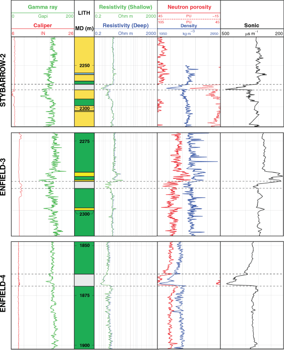
Petrophysical data. Ashfall deposits in Stybarrow-2, Enfield-3 and Enfield-4 possess similar petrophysical signatures (Fig. 8). The tuffs’ gamma response is most noticeable in Enfield-4, where it decreases from >120 gAPI in the bounding shale (which contains radioactive potassium feldspar) to <120 gAPI in the tuff. Resistivity is reduced across the tuff layers in all wells from >2 ohm m in host strata to <2 ohm m in the tuff. An increase in neutron porosity, and a decrease in density, is most obvious in Enfield-4 and Stybarrow-2, from ~0.32 v/v and ~2.3 g cm−3 in bounding strata to ~0.57 v/v and ~2 g cm−3 in the tuff layers, as is a decrease in sonic velocity from over 320 µs m−1 to ~450 µs m−1.
|
The increase in neutron porosity has two causes. The primary cause is a genuine increase in porosity (increasing the water proportion of the bulk rock volume), as the crystalline and glassy structure of the tuff intersected in the wells has begun to break down. The secondary cause is the production of clay minerals as a breakdown product, the hydrated surfaces of which contribute a significant component of the signal. These changes also act to increase electrical conductivity thereby decreasing measured resistivity. Volcanic tuff and its clay-dominated alteration products are less dense than shale, which results in lower seismic velocities in the tuff layers. Enfield-3 has similar neutron density and sonic responses to Enfield-4 and Stybarrow-2; however, they are less apparent. This pattern of petrophysical log changes in altered ashfall deposits is similar to that seen in wells intersecting the volcanic ash of the Balder Clay in the Faroe Shetland Basin, offshore Scotland, UK (Watson et al. 2020).
Issues related to petroleum exploration
Clay swelling. Altered ashfall deposits such as those in Stybarrow-2, Enfield-3, Enfield-4 and at ODP Site 763, are susceptible to clay swelling: the expansion of hydratable clays, such as smectite, by the uptake of water. Smectite minerals with Na+ cations in the interlayer of their atomic structure, such as those encountered in Enfield-4 (Willis 2002), will readily absorb water molecules (Anderson et al. 2010), which can increase clay volume by up to 15 times at surface conditions (Altaner 1978). This effect weakens at elevated pressures and temperatures present in deep boreholes (Anderson et al. 2010). Nonetheless, swelling can cause wellbore instability through cave-ins and expansion of formation into the wellbore, which also causes problems when running casing (Anderson et al. 2010). Hydrated clays can cause cuttings to clump together, affecting borehole cleaning, and can lead to balling of clay on the drillbit (Anderson et al. 2010; Watson et al. 2020). A more costly consequence of clay swelling would be loss of the drilling assembly, forcing a sidetrack, or in the worst case, complete well abandonment (Anderson et al. 2010).
Woodside recognised the risk of clay swelling within ashfall deposits altered to smectite and illite at Enfield-4 (Willis 2002). Traditionally, oil-based drilling muds were used to mitigate clay swelling (Anderson et al. 2010). However, recent environmental concerns have led to oil-based muds being banned in many jurisdictions (Adewale and Ogunrinde 2010). Woodside recommended the use of inhibited muds (Willis 2002). Inhibited muds are water-based, but contain additives that can displace water from the clay’s interlayer, or replace hydrophilic Na+ cations with others (such as K+ or ammonia, NH2+) that are hydrophobic, reducing clay expansion (Anderson et al. 2010).
Proximity of wells to volcanic centres. Stybarow-2, Enfield-3 and Enfield 4 are located between 40 and 60 km from the TVC. If future wells are planned to target reservoirs within Triassic–Middle Jurassic-aged strata closer to the TVC, a thicker section of altered tuff should be anticipated. This is because pyroclastic and ashfall deposits are thicker closer to their source (Cas and Wright 1988). Thicker ashfall deposits altered to smectite would mean a greater chance of clay swelling impacting drilling operations.
Wells that intersect intrusive igneous rocks
Three wells intersect altered intrusive igneous rocks: 1) Palta-1, in which intrusive rocks were not predicted pre-drill; 2) Yardie East-1, which intersected a series of 20 stacked intrusions which vary in thickness between 0.7 and 7.5 m; and 3) Chester-1, where an intersected dyke has implications for compartmentalisation of strata across a broad area of the Exmouth Plateau.
Palta-1 and Palta-1 ST1: intrusion
Geological setting and nature of penetrated igneous rocks
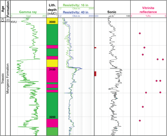
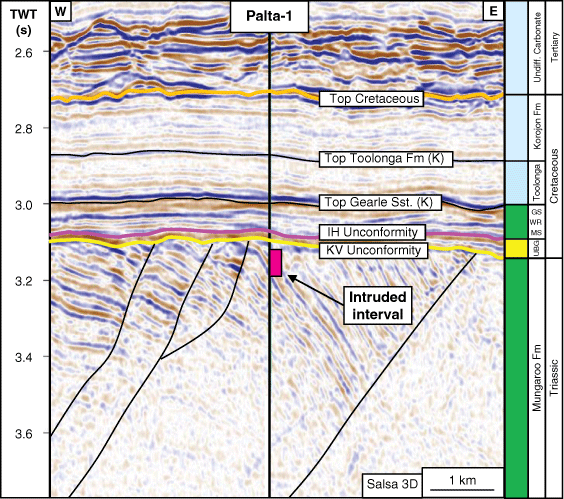
Palta-1 was drilled by Shell in the southern Exmouth Sub-basin between October 2012 and July 2013 (Gibson 2014; Dale 2015). It is located ~100 km west of Exmouth, Western Australia, at the centre of the Salsa 3D seismic survey (Fig. 1). The well targeted sandstone reservoirs within the Triassic Mungaroo Formation and the Permian–Triassic Kennedy Group. Palta-1 was sidetracked at 3100 mMD as Palta-1 ST1. At this locality, the entire Lower Cretaceous and Jurassic sequence was eroded following breakup-related uplift, resulting in the regional KV Unconformity separating the Triassic Mungaroo Formation from the Valanginian Zeepard Formation of the Upper Barrow Group. Post-drilling, an intrusion was identified in Mungaroo Formation rocks between 3005 and 3100 mMD, immediately below the KV Unconformity (Dale 2015). The intrusion is heavily altered, with the alteration assemblage comprising siderite, kaolinite, silica and possible zeolite (Duddy 2015).
Discovery of intrusion post-drill at Palta-1
During drilling, apatite fission track analysis (AFTA) was conducted to define the thermal history of the well due to elevated bottom hole temperatures during drilling. This showed that the drilled rocks had been subject to two distinct cooling episodes (Duddy 2015): (1) in the Early Cretaceous, associated with the removal of the entire Middle Triassic–Earliest Cretaceous sequence (2.6 km erosion), and (2) a short lived episode occurring between 116 and 90 Ma (Aptian–Cenomanian) (Duddy 2015).
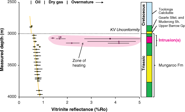
Vitrinite reflectance (VR) is a measure of thermal maturity of source rocks. Analysis following drilling revealed elevated VR values of up to ~5% Ro were present in samples collected from a sandstone over the interval ~3025–3150 mMD (Duddy 2015) (Fig. 9). These results are not consistent with gradual heating by burial, which exhibits a consistent, increasing downwards reflectance-depth trend. Several thin sections were made up from the AFTA samples to investigate a possible cause for the localised spike in VR values. Thin sections from 3105 to 3110 mMD and at 3160 mMD (Fig. 10) show that relic igneous textures (plagioclase feldspar, pyroxene and Ti–Mg minerals) have been pervasively replaced by principally siderite (iron carbonate) as well as silica, kaolinite and possible zeolite (Duddy 2015). This strongly suggests that the increase in VR values across the interval is related to intrusion-related conductive heating (Holford et al. 2013).
|

|
Mudloggers noticed an increase in carbonate material across the interval 3082–3139 mMD (end of hole) in Palta-1 and the presence of carbonate/dolomitic material from 3110 to 3176 mMD in Palta-1 ST1 (Gibson 2014) and referred to the interval as a ‘dolomite cemented zone’ (Duddy 2015). Siderite identified in thin section later accounts for the mudloggers’ use of the terms ‘dolomite’, ‘dolomitic’ and ‘calcareous’ through the interval, and its replacement of igneous textures is related to secondary hydrothermal alteration of the intrusion (Duddy 2015). Hydrothermal alteration could also account for the presence of siderite and silica cement in the pores of the host sandstone. If these hot fluids were driven off the intrusion into the country rock as it cooled, this would constrain the intrusion to being emplaced sometime between 116 and 90 Ma, as identified from AFTA (Duddy 2015). This age range coincides with that of intrusions in the southern Exmouth Sub-basin, where subcrop beneath an Aptian-aged unconformity constrains the intrusions’ youngest age to 113 Ma (McClay et al. 2013; Mark et al. 2020).
Constraining the thickness of the intrusion is difficult. Elevated VR values are present from 3025 to 3150 mMD, and igneous rocks were confirmed from 3105 to 3110 mMD and at 3160 mMD. Hence, the top of the intrusion was likely at or above 3105 mMD and below 3025 mMD. As the deepest igneous sample was collected below the base of the elevated VR zone, it could be the result of caving. Therefore, the base of the intrusion is likely at or below 3110 mMD but above 3150 mMD. The intrusion is not resolved on seismic data. It is possible it is narrower than the vertical resolution of the seismic reflection dataset at this depth (e.g. Schofield et al. 2017). It is also possible that the clay component of the alteration has reduced the acoustic impedance of the intrusion, making it difficult to differentiate from host strata within seismic reflection data. Several thin intrusions over the same interval would also fit these observations and provide an explanation for one population of VR samples at 3025 mMD having ~4% Ro and another population from the same depth having background levels of ~0.8% Ro (although these lower VR value samples may also be the result of caving from overlying strata). As the samples containing igneous rock and associated alteration minerals are hosted within a band of sandstone, and not associated with shale intervals above and below, it is possible that the sandstone was preferentially intruded.
Characterisation of igneous rocks
Seismic expression. Palta-1 was drilled on the Salsa 3D seismic reflection survey (Fig. 1). Despite high acoustic velocities over the interval (Fig. 11), the intrusion is not resolved in seismic reflection data (Fig. 12). It is likely that the intrusion is thinner than the vertical resolution of the seismic data or possibly too pervasively altered to be distinguished from the host rock, which is characterised by steeply dipping alternating cemented deltaic sands and shales of high acoustic impedance contrast (Fig. 12).
|
|
Petrophysical data. Fig. 11 shows petrophysical logs through the intruded zone at Palta-1. Gamma ray decreases at the top of the high VR zone from ~120 to ~30 gAPI and remains low until ~3105 mMD, where it gradually returns to ~140 gAPI at the base of the zone at ~3150 mMD. Resistivity spikes from ~5 to ~80 Ohm m at ~3095 mMD and gradually decreases to background shale values of ~10 Ohm m by 3150 mMD. A separation of the deep and shallow resistivity curves of ~50 Ohm m accompanies the initial increase in resistivity at ~3095 mMD. Sonic velocities also increase from ~300 μs m−1 in host strata to ~200 μs m−1 from ~3100 to ~3145 mMD.
Rocks over the interval were logged as alternating beds of sandstone and siltstone, with varying concentrations of carbonate (Gibson 2014; Dale 2015). However, the gamma ray value is lower and the resistivity peak higher than for any other clastic rock in the well. The fact that these petrophysical trends correlate with the zone of high VR and samples of relict igneous rock suggests that they instead represent the pervasive siderite alteration of the intrusion and host sandstone on either side. Low gamma ray values may be the result of no radioactive potassium feldspar in the altered mafic mineralogy, a peak in resistivity resulting from a lack of porosity and low clay content, a resistivity separation resulting from a degree of permeability over a narrow zone, and elevated sonic speeds resulting from higher densities. This suggests a zone of fractured, highly cemented material representing mafic igneous rocks and iron-rich siderite alteration.
Issues related to petroleum exploration
Non-recognition of altered igneous rocks. At Palta-1, igneous rocks went unrecognised by drillsite staff who classified an intrusion pervasively altered to siderite and clay, and siderite and silica cemented host rocks, as alternating bands of sandstone and siltstone containing dolomite and argillaceous clay over an ~100 m interval. This highlights the difficulty in recognising altered igneous rocks in hand specimen, especially when not anticipated prior to drilling. If not for the thermal history analysis – which was conducted to clarify uncertainty regarding the present-day temperatures in the well – this intrusion may have remained unrecognised. Lack of recognition of intrusions has implications for pre-drill basin modelling. As intruded igneous rocks cool, their heat is dissipated into the surrounding host rocks. Conductive heating by multiple, stacked intrusions can overmature organic matter in proximal host rocks (as at Yardie East-1, see following section). If such intrusions are not detected, an exploration team might interpret a more regional cause for overmaturation and dismiss drilling opportunities nearby but outside of the intrusions’ influence.
A possible solution would be to ensure that wellsite logging geologists have an awareness of mafic igneous rocks and their alteration products and have access to tools, such as hand-held X-ray flourescence (XRF) machines, to aid in identification of igneous minerals and their alteration products. Taking note of intervals that appear to be hydrothermally altered would provide a useful flag for later analysis. For example, at Palta-1, siderite could have possibly been distinguished from dolomite by its higher density (~3.96 vs 2.84 g cm−3).
Yardie East-1: intrusions
Geological setting and nature of penetrated igneous rocks
Yardie East-1 was drilled onshore, on the western edge of the Exmouth Peninsula, by MESA Australia Ltd in 1982 (Kjellgren et al. 1982) (Fig. 1). The well deviated offshore, targeting oil in a four-way dip closed structure in the Early Jurassic Learmonth and Triassic Mungaroo formations.
Yardie East-1 intersected a series of 20 altered dolerite intrusions in Jurassic and Triassic sedimentary rocks beneath the Callovian Unconformity (Table 2). The intrusions range in thickness from 0.7 to 7.5 m and are emplaced into the Athol (Upper Interval), Brigadier (Middle Interval) and Mungaroo (Lower Interval) formations. No intrusions are present in the Lower Jurassic Learmonth Formation. At this locality, the Athol Formation is composed of dominantly claystone, the Learmonth Formation of sandstone, the Brigadier Formation of siltstone interbedded with sandstone and claystone, and the Mungaroo Formation of dominantly sandstone interbedded with claystone and siltstone (Kjellgren et al. 1982).

|
The intrusions range from fresh to appreciably altered. Descriptions of thin sections taken from sidewall cores and drill cuttings (Fig. 13) report that original intrusion mineralogy is predominantly Ca-plagioclase feldspar, pyroxenes, amphiboles and olivine, and that alteration is overwhelmingly dominated by dolomite and calcite replacement of plagioclase, with less extensive occurrences of chlorite replacing ferromagnesian minerals and occasional sericitisation of plagioclase (Kjellgren et al. 1982).

|
Characterisation of igneous rocks
Seismic expression
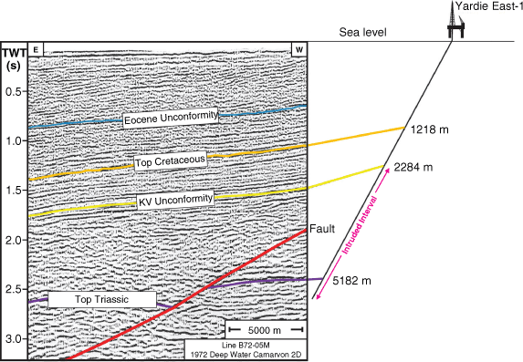
Line B72-05M from the 1972 Deep Water Carnarvon Basin 2D Seismic Survey by the Western Geophysical Company of America (now Western Geco) approaches Yardie East-1 at its south-eastern end (Fig. 1), and is tied to the well by Müller et al. (2002) (Fig. 14). No intrusions are visible on this seismic line. Despite this, Müller et al. (2002) suggest that the intrusions in Yardie East-1 should be visible on seismic sections due to their fast acoustic velocity relative to the host sedimentary rock. We disagree, and suggest that individual intrusions would not be fully resolved in seismic reflection data and may not be detectable, as they are too thin; 0.7–7.5 m intrusion thickness is below both the vertical resolution and detection limit of the seismic reflection data available (Schofield et al. 2017). Also, alteration would have reduced the intrusions’ acoustic impedance contrast with host strata, making them difficult to differentiate.
|
Petrophysical data
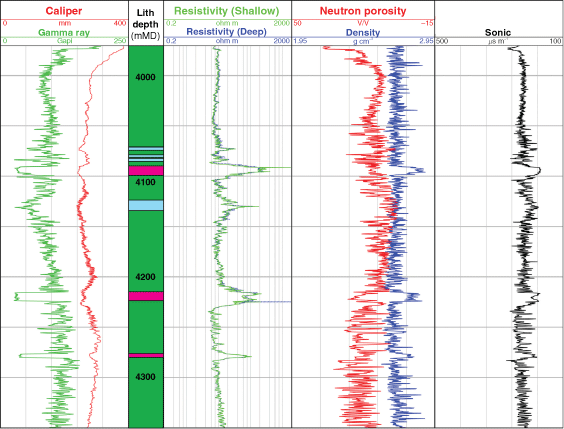
The intrusions are evident on petrophysical log data (Fig. 15). Gamma ray values are low (typically ~35 gAPI). This is likely due to the low abundance of radioactive potassium feldspar in mafic igneous rocks. The gamma curve is blocky over the intrusions due to this abrupt change in mineralogy. Resistivity is high across the intrusions (up to ~200 ohm m). This is expected, as igneous rock is crystalline, with little porosity, and contains little pore water. The intrusions are relatively dense compared to the host rock due to high concentrations of ferromagnesian minerals, such as pyroxene and hornblende. There is strong local positive separation of the neutron porosity and density log curves, relative to the host shale. Acoustic velocity is high (with a sonic P-wave slowness of ~165 μs m−1) due to the greater density and hardness of mafic igneous rocks relative to shale.
|
Resistivity and acoustic velocity response is high within the intruded intervals. Unlike the blocky gamma response, resistivity and sonic log values decay to background shale levels over a wider interval within host rocks, typically ~50% of the intrusion width (e.g. between 4215 and 4224 mMD, Fig. 15). This resistivity and sonic log curve shape either side of an intrusion is seen in Well 219/21-1 in the Faroe Shetland Basin (McLean et al. 2017), where it corresponds with thermal contact metamorphism of the host rock in a hornfels zone (Watson et al. 2019).
Issues related to petroleum exploration
Maturation of organic matter in host rocks due to contact metamorphism
Eight samples in Jurassic and Triassic strata from Yardie East-1 were analysed for VR (Fig. 16). Average VR values range from 1.32% Ro at 3093 mTVD to 2.20% Ro at 3230 mTVD. The three highest values of average VR (2.20, 2.12 and 2.07% Ro) are present over a narrow interval between 3230 and 3380 mTVD within the Athol Formation (Fig. 16). As observed in Palta-1, these results are not consistent with gradual heating by burial (Link 1982). When compared to the trends from the two closest offshore wells for which VR data is available, Malaguti-1 and Murat-1 (38 km northwest and 27 km northeast from Yardie East-1 respectively; Fig. 1), it can be seen that the background VR-depth trend is significantly higher in Yardie East-1. Source rocks in Malaguti-1 and Murat-1 are mature for oil generation, whereas rocks at Yardie East-1 are either mature for dry gas generation or overmature. Textural characteristics of organic matter from Yardie East-1 suggest that the source rocks were in the ‘immature’ window for generation, with a VR value of ~0.45% Ro (Kjellgren et al. 1982) prior to the emplacement of intrusions.

|
The three high VR values are within the Upper intruded interval within Yardie East-1, whereas the remaining lower VR values fall outside of the Upper, Middle and Lower intruded intervals (Fig. 16). This implies that heat from intrusions has locally overmatured organic matter in the Upper intruded interval within the Athol Formation. This is also likely the case for organic matter in vicinity of intrusions in the Brigadier and Mungaroo formations, suggesting ~600 m (vertical thickness) of rocks have been thermally altered at Yardie East-1.
The presence of intrusions may also account for the appearance of a background VR-depth trend that has been stepped up by ~0.8% Ro at Yardie East-1. Authors of the thermal history report for Yardie East-1 note ‘the textural appearance of vitrinite and the range of reflectances found suggest significant contact metamorphism’ (Kjellgren et al. 1982). They suggest a peak temperature of ~210°C was attained in the host rock, with heating between 145 and 175°C lasting ~20 Ma, generating a thermal impact likely extending upwards to ~2500 m vertical depth (Kjellgren et al. 1982).
This suggests that if organic-rich source rocks are intruded by larger volumes of magma elsewhere, they may become overmature for hydrocarbon generation, although conversely, a large intrusive system has the potential to generate hydrocarbons from otherwise immature source rocks (e.g. in the Taranaki Basin, New Zealand; Stagpoole and Funnell 2001).
Compartmentalisation of source rocks
Twenty intrusions are present over a vertical interval of ~1000 m within Jurassic and Triassic strata (Table 2). This may have caused compartmentalisation, resulting in the retardation of upward and lateral migration of hydrocarbons, as described by Holford et al. (2013).
Chester-1 and ST1: dyke
Geological setting and nature of penetrated igneous rocks
Chester-1 was drilled by Hess in 2013 (Jakymec 2013). The well is located in the southeast of the Glencoe 3D Seismic Reflection Survey on the Exmouth Plateau (Fig. 1). The well was sidetracked as Chester-1 ST1 at a depth of 2314 mMD due to loss of circulation in the wellbore. It discovered 90 m net gas pay in the Triassic Mungaroo Formation and 13.6 m net gas pay in the Cretaceous Lower Barrow Group (Jakymec 2013).
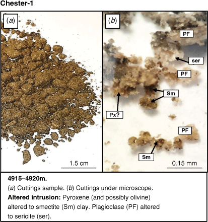
Unexpectedly, Chester-1 ST1 intersected mafic igneous rock in the Mungaroo Formation between 4910 and 4957 mMD. Wellsite lithological logs describe the igneous material as grey/green in colour, blocky and relatively soft. Analysis of samples from Chester-1 between 4915 and 4920 mMD revealed that, in places, igneous rock has been pervasively altered to a friable green clay, which contains plagioclase crystals showing sericite alteration and Fe–Mg minerals altered to smectite (Fig. 17). Although first interpreted as extrusive (Jakymec 2013), these igneous rocks have been recently reinterpreted as intrusive and related to Late Jurassic and Early Cretaceous rifting prior to the breakup of Greater India and Australia (Magee and Jackson 2020).
|
Characterisation of igneous rocks
Seismic expression
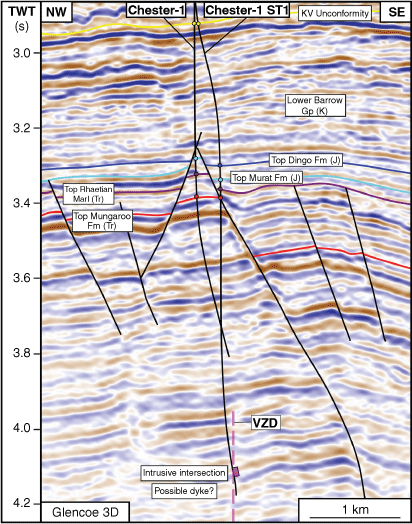
The mafic igneous rock is not imaged on the Glencoe 3D Seismic Reflection Survey (Fig. 18). If it were a lava flow (as first interpreted) or a horizontal sill, its vertical thickness would be 45.6 m (intersection of 47 m, borehole dip is 18° from vertical), thicker than the ~19–25 m vertical seismic resolution of the dataset (Magee and Jackson 2020), and hence, resolvable on seismic data. Pervasive clay alteration may have reduced the acoustic impedance of the intrusion, rendering it seismically indistinguishable from host siliciclastic strata, although high density (~2.9 g cm−3) and relatively fast sonic velocities (average ~60 ms ft−1) (Fig. 19) through much of the intruded interval suggest otherwise. Magee and Jackson (2020) instead suggest the intrusion is a sub-vertical to vertically oriented dyke, proposing a thickness of 14.8 m. They note vertical zones of disruption (VZD) in seismic reflection data (in which reflections are deflected upwards and amplitudes are reduced; Wall et al. 2010; Holford et al. 2017; Ardakani et al. 2018) across the Exmouth Plateau to which they attribute the presence of a vertically oriented dyke swarm. One of these VZDs coincides with the intersection of igneous rock in Chester-1 (Fig. 18).
|
|
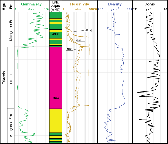
Petrophysical data
The intruded interval has a flat, blocky gamma response, decreasing over a narrow interval (<2 m) from ~200 and ~50 gAPI in overlying shales and sandstones, respectively, to ~6 gAPI in the intrusion (Fig. 19). These low gamma values are due to the immediate change to a lack of potassium feldspar in mafic igneous rock. Shallow resistivity and density increase over a wider interval (~10 m) towards the intrusion on both sides from ~2 to ~200 ohm m and from ~1.65 (overlying shale) and ~1.5 (underlying sandstone) to ~2.9 g cm−3 within the intrusion. This likely represents gradual porosity reduction towards the intrusion over the same interval (from ~0.15 to ~0.07 porosity units), the result of thermal metamorphism and re-crystallisation of the host rock, defining the contact aureole, or possibly the deposition of minerals in available pore space by hydrothermal fluids driven off the intrusion during cooling. Sonic velocity (P-wave slowness) is variable across the intrusion, ranging from as low as 108 μs ft−1 over several intervals ~1 m wide to 33 μs ft−1 in other parts of the intrusion. The sonic log, more than most, may reflect the variability in how pervasively altered the intrusion is, with soft clay intervals reducing sonic velocity and harder, more crystalline sections retaining high sonic velocities.
Issues related to petroleum exploration
Presence of dykes in the Exmouth Plateau
Magee and Jackson (2020) have interpreted the igneous rock in Chester-1 as belonging to part of an Exmouth Dyke Swarm, which they define from the continuation of 26 VZDs in a ~40° arc across the western Exmouth Plateau (Fig. 1). Interpreted dykes are up to 171 km long from tip to tip and up to 350 m wide (Magee and Jackson 2020). The Exmouth Dyke Swarm appears to be sourced from the northern part of the Cuvier margin, southwest of the Exmouth Sub-basin (Fig. 1), and it is likely emplaced in the Late Jurassic, following intrusion of the 45 000 km2 interconnected sill complex defined by Symonds et al. (1998) and preceding the Early Cretaceous separation of Greater India from Australia (Magee and Jackson 2020). Minor offset conjugate fault sets and fluid escape features defined by Velayatham et al. (2018) and Velayatham et al. (2019) are interpreted to mark the surface expression of the Exmouth Dyke Swarm on the Early Cretaceous KV Unconformity, while the VZDs, and hence the dykes, terminate within the Triassic Mungaroo Formation (Magee and Jackson 2020).
Dykes are vertical to sub-vertical features composed of impermeable crystalline igneous rock. Although parts of the Exmouth Dyke Swarm have been altered to clay (Fig. 17), porosity in the vicinity of intrusions is likely further reduced by contact metamorphism of host strata (Holford et al. 2013). The Exmouth Dyke Swarm therefore presents a possible barrier to lateral hydrocarbon migration in the Triassic Mungaroo Formation and Locker Shale, further contributing to source and reservoir compartmentalisation due to the presence of the interconnected sill and dyke complex (Symonds et al. 1998; Holford et al. 2013).
Discussion
We have highlighted key issues faced by explorers while drilling through igneous rocks in the NCB. Seven petroleum exploration wells and two scientific boreholes have been examined; these penetrate volcanoes, ashfall deposits and intrusions. In many wells, these issues were the direct result of pervasive alteration of the penetrated igneous rock and include the interpretation of possible overpressure within the volcanic sequence at Toro-1; swelling clays arising from alteration of ashfall deposits at Stybarrow-2, Enfield-3 and Enfield-4; lack of recognition of an altered intrusion at Palta-1; source rock maturation at Yardi East-1; and compartmentalisation of source and reservoir rocks at Chester-1.
Here, we discuss how igneous rocks in the studied wells may have been altered and the difficulties in identifying these altered igneous rocks. We then address the issue of why so few NCB wells have penetrated igneous rocks compared to other basins at magma-rich margins.
Alteration of igneous rocks
The setting of igneous rocks within the NCB
Igneous rocks can be emplaced into many settings in basins on rifted margins prior to breakup (Fig. 20). Within the NCB, a >45 000 km2 network of stacked, interconnected intrusions is present at depth (between 4 and 8 sTWT) within Triassic Mungaroo Formation rocks of the Exmouth Plateau (Fig. 1; Symonds et al. 1998; Holford et al. 2013; Rohrman 2013). We believe intrusions in Yardie East-1 to be interconnected in a similar fashion, albeit at a smaller scale and at shallower depths (a, Fig. 20). Isolated saucer-shaped intrusions, up to 10s of km in diameter, are observed in Jurassic strata within the central region of the Exmouth Sub-basin (b, Fig. 20; e.g. Magee et al. 2013a, 2013b, 2016; 2017), while significant fault control is exerted on an intrusive network in the south of the Exmouth Sub-basin (e.g. c, Fig. 20; McClay et al. 2013; Mark et al. 2020). Palta-1 is drilled in a region of intense rotated block faulting within the Triassic Mungaroo Formation (Fig. 12); we propose that one of these faults may have provided a pathway for magma ascent. Extrusive volcanic cones (d, Fig. 20) have been documented in shelfal marine settings in the western Exmouth Sub-Basin at the TVC (penetrated by Toro-1) and close to the Pyrenees field development (Black et al. 2017; O’Halloran et al. 2019). Ashfall deposits (e, Fig. 20), likely dispersed by ocean currents, have been reported across the Exmouth Sub-basin (Stybarrow-2, Enfield-3 and Enfield-4), Exmouth Plateau (ODP 763 B and C) and the Barrow Sub-basin (Tait 1985; Shipboard Scientific Party 1990; Willis 2001, 2002; Locke 2004).

|
Generation and migration of alteration fluids
Alteration is defined ‘as any change in the mineralogical composition of a rock brought about by physical or chemical means, especially by the interaction with hot or cold aqueous fluids’ (Gifkins et al. 2005; Guilbert and Park 2007). Alteration recorded in igneous rocks in the wells in this study is chemical in nature. Fluids affecting volcanic rocks in the Exmouth Sub-basin during their eruption were possibly sourced by seawater and precipitation (the TVC was at least 450 m high and formed in a shelfal to nearshore marine setting where water depths were likely 10s to 100s of m, so it possibly protruded above sea level at times (Curtis et al. 2021)) (Fig. 20). In the subsurface of the NCB, alteration fluids affecting intrusive rocks likely include porewater, with hydrothermal convection driven by heat from bodies of emplaced magma, and hot magmatic fluids (comprised predominantly of H2O and CO2 (Steele-MacInnis et al. 2018)) exsolved from cooling magma and driven into the host rock (Fig. 20). Once NCB extrusive rocks were buried, they would have also been subject to subsurface alteration processes. In this study, we have also documented the alteration of host rocks that is both physical, due to thermal contact metamorphism, and chemical in nature, due to interaction with fluids.
Hydrothermal fluids often preferentially exploit faults (Fairley 2009; Magee et al. 2016), bedding planes (Searl 1991) and other weaknesses in the crust. Fractures within intrusions can be conduits for fluid migration (e.g. Rateau et al. 2013; Senger et al. 2014) (Fig. 18). Or, if impermeable, intrusions may baffle fluids, forcing migration along their edges (e.g. Holford et al. 2013) (Fig. 20). Hydrothermal vents have been recorded on the paleoseabed above the tips of intrusions in the NCB (Magee et al. 2013a, 2017; Magee and Jackson 2020), demonstrating the ability of pressured hydrothermal and magmatic fluids to also move vertically through bedded strata (Fig. 20).
Alteration of NCB intrusive igneous rocks
Intrusions intersected in the wells in this study are doleritic in composition (Kjellgren et al. 1982; Jakymec 2013; Dale 2015) and would initially have been composed of plagioclase and clinopyroxene (e.g. diopside – CaMgSi2O6) (McBirney 1993) (Table 3). These minerals are susceptible to alteration by CO2- and H2O-rich fluids. CO2 and H2O combine, forming carbonic acid (H2CO3), which dissociates into H+ and CO32− ions in the fluid (Moita et al. 2020). H+ reacts with feldspar and clinopyroxene, liberating Ca2+ and Mg2+ ions into the fluid (Moita et al. 2020). These ions combine with CO32− and precipitate carbonates (Moita et al. 2020). This is likely responsible for extensive carbonate precipitation in Yardie East-1. The CO2 was likely sourced from magmatic fluid driven off the mafic melt, as suggested in other Australian volcanic rift basins (e.g. the Browse and Otway basins) (Watson et al. 2004; Yule and Spandler 2021) but could possibly have come from combusted organic matter or hydrocarbons as a result of contact metamorphism of host shales (e.g. Aarnes et al. 2010; Yule and Spandler 2021). Iron in siderite (FeCO3) observed in Palta-1 may have been sourced by an iron-rich phase within the crystalline dolerite (e.g. iron-bearing olivine, clinopyroxene or magnetite), from an iron-bearing magmatic fluid or from iron oxides in host rocks subject to a reducing environment by magmatic fluids. Clay, chlorite and sericite alterations encountered in the intrusive rocks (Table 3, Figs. 6, 10, 13) are perhaps due to hydration of plagioclase feldspar and pyroxene by porewater.

|
Alteration of NCB volcanic deposits
Prior to alteration, mafic volcanic glass would have been the primary constituent of ashfall deposits in the Enfield-3, Enfield-4, Stybarrow-2 and ODP 763 boreholes (Cas and Wright 1988). Volcanic glass readily hydrates in the presence of an alkaline fluid (e.g. seawater, pH ~8.1) (Gifkins et al. 2005). Water (H2O) and K2O are absorbed, forming palagonite (a waxy, resin like substance), while SiO2, CaO and Na2O are lost into the fluid phase (Gifkins et al. 2005). As the extrusive rocks are buried and undergo diagenesis, new minerals grow, including clay minerals (predominantly smectite in mafic settings), carbonates (calcite and dolomite) and zeolites, that replace palagonite and cement fractures, vesicles and porespaces (Gifkins et al. 2005). This may explain the predominance of smectite and calcite as alteration phases in Stybarrow-2, Enfield-3, Enfield-4 and ODP 763 (Table 3, Fig. 6), indicating that the altering fluid was likely alkaline seawater.
Extrusive volcanic rocks at Toro-1, likely erupted into seawater, would have initially been composed of rapidly cooled volcanic glass. Like ashfall deposits, they would have been immediately susceptible to alteration by circulating ocean water. Furthermore, the Tithonian-aged TVC immediately overlies a network of intrusions, emplaced following faulting that intersects the TVC (Fig. 3) (Magee et al. 2016). Both magmatic fluids and groundwater, driven by heat from the intrusion and possibly focussed along the faults, may have also contributed to clay and carbonate alteration observed in the Toro-1 well.
Contact alteration of sedimentary host rocks
As an intrusion cools, it spreads heat into surrounding host rock through conduction and convection of fluids. This results in contact metamorphism (leading to physical changes) and hydrothermal alteration (leading to chemical changes) of the host rock (Gifkins et al. 2005) in a halo surrounding the intrusion (Fig. 20). Thermal contact metamorphism is documented in Yardie East-1 and Palta-1 (Kjellgren et al. 1982; Dale 2015) (Figs. 9, 16). In both wells, vitrinite reflectance data shows that intruded intervals comprising Triassic and Jurassic sedimentary rocks were subject to localised heating and overmaturation. This follows the trend of a reduction in total organic carbon towards intrusions emplaced into siliciclastic rocks elsewhere, e.g. sills on Svalbard, Norway (Senger et al. 2014).
Hydrothermal alteration and mineral precipitation within host rocks can be interpreted from cuttings descriptions in each well. In Chester-1, the matrix of interbedded sands and claystones immediately above the intrusion is described as containing up to 30% kaolinite clay and 10% dolomitic cement and is ‘siliceous in part’, while clay-altered feldspar and dolomite cement are recorded in sandstone below. In Palta-1, pyrite nodules and veins, and siliceous and calcareous cement leading to ‘no visible porosity’, are present within sandstone, and hydroturgid (swelling on contact with water) clays are present within siltstones in the intruded interval. Sandstone overlying an intrusion in the Mungaroo Formation in Yardie East-1 is described as containing calcite cement and quartz overgrowths with no visible porosity (Fig. 13). These descriptions are suggestive of hydrothermal alteration and cementation as described in the previous sections.
The zone of heat transfer, i.e. the contact metamorphic aureole, is represented by a zone containing a bell-shaped increase in resistivity and sonic velocity towards an intrusion (itself represented by a blocky gamma response) on petrophysical logs (Mark et al. 2018). The width of the aureole can range from 0.3 to 5 times the intrusion’s thickness (Aarnes et al. 2010; Holford et al. 2013). Such aureoles are apparent in petrophysical data from both Yardie East-1 (Fig. 15) and Chester-1 (Fig. 19).
Expression of altered igneous rocks in seismic data and hand specimen
A recurring theme throughout this study has been the difficulty in correctly identifying altered igneous rocks, both on seismic reflection data and in physical specimens recovered from drilling. The Toro volcano, part of the TVC, was referred to as an ‘unidentified seismic object’ prior to drilling Toro-1 (Sturrock 2014), which was believed to be overpressured due to low internal seismic velocities (Sturrock 2014; Taylor 2014). This was not the case, as the low seismic velocities were confirmed to be caused by clay alteration of volcanic rocks. The TVC’s seismic signature was also mistakenly interpreted as a series of infilled hydrothermal vent craters by Magee et al. (2016), whose seismic dataset (Indian 3D) did not extend far enough north to encompass the Toro-1 well. Following a lack of imaging of intrusions on seismic reflection data prior to drilling at Palta-1, carbonate- and clay-altered igneous rocks were misidentified as dolomite, sandstones, claystones and siltstones in cuttings over an interval of ~100 m (Gibson 2014; Dale 2015). The altered igneous rock in Chester-1 was initially interpreted as a ~50 m thick Triassic-aged lava flow. However, as it was not resolved on seismic data, it is much more likely to be vertically oriented and part of the recently discovered Exmouth Dyke Swarm (Magee and Jackson 2020). Both altered intrusions at Yardie East-1 and altered ashfall deposits in Stybarrow-2, Enfield-3 and Enfield-4 are too narrow to be resolved on seismic reflection data (Figs. 7, 13, 14) which made intersecting these rocks difficult to predict ahead of drilling.
Considerations for future exploration
The difficulties in imaging and identifying igneous rocks highlighted in this study show that explorers firstly need to incorporate a regional understanding of the NCB igneous system into their pre-drill assessments in order to predict the likelihood of intersecting igneous rocks. Our study has shown that igneous rocks in the NCB are typically altered, and explorers should anticipate this and the associated issues discussed in previous sections. Toro-1 confirms that dome-shaped features with amorphous seismic character in the western Exmouth Sub-Basin, within the Indian 3D and HE94 2D seismic reflection surveys (Figs. 3, 7), are altered Tithonian volcanoes; ashfall deposits in Stybarrow-2, now altered to smectite, can be tentatively correlated with the TVC, suggesting the presence of altered tuff deposits within a radius of at least 50 km surrounding, and potentially thickening towards, the TVC. Finally, the distribution of intrusions intersected at Chester-1, Yardie-East-1 and Palta-1 is a reminder of the vast spatial extent of the NCB igneous system (~45 000 km2; Symonds et al. 1998), that intrusions are often not always apparent on seismic data, and that intrusions may cause compartmentalisation of both source and reservoir rocks (e.g. Holford et al. 2013). Finally, misidentification of igneous rocks at Palta-1 indicates that drillsite logging staff would benefit from an awareness of igneous rocks, their alteration products, and contact metamorphism and alteration of host rocks in hand specimen. This could be aided by equipping logging teams with portable XRF machines to assist in mineral identification.
Although a series of stacked intrusions are associated with overmatured sedimentary rocks at Yardie East-1, this need not imply that localised heating by intrusions is always detrimental to hydrocarbon maturation. In some cases, heating from intrusions has been shown to positively contribute to hydrocarbon generation, such as in the Ne’quen Basin in Argentina (Monreal et al. 2009) and in the Taranaki Basin in New Zealand (Stagpoole and Funnell 2001). This shows that in areas of the NCB where source rocks have not been buried to depths typically associated with hydrocarbon generation they may have reached maturity if associated with large intrusive igneous systems. Furthermore, pervasive intrusion of igneous rock into sedimentary sequences can have a more permanent impact on hydrocarbon generation by ‘otherthickening’ overburden and causing potential source rocks to be buried deeper than they would in the absence of igneous activity (Mark et al. 2018).
Lack of igneous rock penetrations in wells in the NCB
We have identified seven petroleum exploration wells and two scientific boreholes that penetrate igneous rocks in the NCB. These wells represent <0.5% of all exploration wells drilled to date in the basin. This is a very small proportion compared to other basins on rifted volcanic margins. For example, 20 of 36 exploration wells (56%) drilled in the Bass Basin, Southern Australian Margin, and 19 of ~190 (10%) exploration wells drilled in the Faroe Shetland Basin offshore Scotland, UK, intersect igneous rocks.
Why are there so few reported intersections of intrusions in the NCB? We have shown that igneous rocks in the NCB are often difficult to identify on seismic reflection data ahead of drilling. We have also highlighted the pervasive alteration of igneous rocks that have been penetrated in the NCB, which further adds to complexity in resolving them on seismic data and also makes them difficult to identify in hand specimen. Due to such difficulties associated with the identification of igneous rocks it is possible that there may be wells in the NCB where igneous rocks have in fact been intersected but not identified correctly, and hence, not recorded and reported.
Also, the magmatic record of the NCB is dominated by intrusions within the Triassic Mungaroo Formation (Symonds et al. 1998; Holford et al. 2013; Rohrman 2013). These intrusions are typically situated deeper than the majority of target reservoirs in the region, which tend to be within the Lower Cretaceous Barrow Group. For example, six wells (Scarborough 1–5 and North Scarborough-1) have targeted Cretaceous Barrow Group reservoirs at the Scarborough Gas Field (associated WCRs), yet below, in Triassic rocks, an extensive network of stacked and interconnected intrusions is emplaced. It is likely that this spatial dissociation of the igneous rock from target plays also contributes to the lack of penetrations of igneous rocks in the NCB.
Conclusions
We have analysed well data, petrophysical data and seismic data associated with seven petroleum exploration wells and two scientific boreholes that penetrate igneous rocks in the NCB. The nature of igneous rocks penetrated within the basin varies. Remnants of volcanoes and ashfall tuffs are present along with intrusive sills and dykes. These igneous rocks, and their host rocks, have been subject to significant alteration.
The presence of altered igneous rock in the NCB has caused:
Difficulties in imaging altered igneous rocks on seismic reflection data prior to drilling;
Difficulties in correctly identifying altered igneous rocks in cuttings;
Difficulties in pore pressure prediction in volcanic sequences;
Contact alteration and localised overmaturation of organic matter in sedimentary strata; and
Possible basinwide compartmentalisation of strata.
The alteration of igneous rocks is the result of complex, multifaceted chemical processes. When drilling in igneous-affected areas of the NCB, exploration teams will benefit from an appreciation of the processes of alteration fluid generation and migration and an awareness of alteration mineral assemblages associated with altered mafic igneous rocks and host rocks. If igneous rocks are missed or incorrectly identified, important information relating to the magmatic and tectonic history of a region cannot be incorporated into regional basin models. Furthermore, at a global scale, the very real difficulty in identifying altered igneous rocks combined with their ubiquitous presence in the NCB suggests that igneous systems may be present but unrecognised in petroleum basins on rifted margins worldwide.
Data availability
All well and seismic reflection data used in this study was accessed through the National Offshore Petroleum Information Management System (NOPIMS; https://nopims.dmp.wa.gov.au/Nopims/) and the West Australian Petroleum Information Management System (WAPIMS; https://wapims.dmp.wa.gov.au/WAPIMS/).
Conflicts of interest
All authors confirm there are no conflicts of interest.
Declaration of funding
This work was funded through a postgraduate scholarship from the University of Adelaide, Faculty of Engineering Computer and Mathematical Sciences, and also by ASEG Research Foundation Grant no. RF19P01.
Acknowledgements
We would particularly like to thank Hugo Olierook of Curtin University for his time and efforts in organising to view and collect samples from the Perth Core Library for Chester-1 and for input in interpreting alteration mineral assemblages. We would also like to thank Ian Duddy of Geotrack, who authored the thermal history analysis report at Palta-1, for discussions and early direction with the Palta-1 section of this manuscript; and Roozbeh Koochak of the Australian School of Petroleum and Energy Resources (ASPER), for lengthy discussions relating to the interpretation of well logs. We gratefully acknowledge the institution of ASPER at the University of Adelaide where this work was completed.
References
Aarnes, I, Sense, H, Connolly, JA, and Podladchikov, YY (2010). How contact metamorphism can trigger global climate changes: Modeling gas generation around igneous sills in sedimentary basins. Geochimica et Cosmochimica Acta 74, 7179–7195.| How contact metamorphism can trigger global climate changes: Modeling gas generation around igneous sills in sedimentary basins.Crossref | GoogleScholarGoogle Scholar |
Adamson K, Lang S, Marshall N, Seggie R, Adamson N, Bann K (2013) Understanding the Late Triassic Mungaroo and Brigadier Deltas of the Northern Carnarvon Basin, North West Shelf, Australia. In ‘West Australian Basins Symposium 2013, 18–21 August 2013, Perth, WA’.
Adewale D, Ogunrinde J (2010) Development of environmentally friendly oil based mud using palm-oil and groundnut-oil. Paper presented at the Nigeria Annual Internaiton Conference and Exhibition, July 31–August 7 2010. Paper number: SPE-140720-MS.
| Crossref |
Altaner SP (1978) Smectite group. In ‘Encyclopedia of Sediments and Sedimentary Rocks’. (Eds GV Middleton, MJ Church, M Coniglio, LA Hardie, FJ Longstaffe) pp. 675–677. (Springer: The Netherlands: Dordrecht)
Anderson, R, Ratcliffe, I, Greenwell, H, Williams, P, Cliffe, S, and Coveney, P (2010). Clay swelling—a challenge in the oilfield. Earth-Science Reviews 98, 201–216.
| Clay swelling—a challenge in the oilfield.Crossref | GoogleScholarGoogle Scholar |
Ardakani, EP, Schmitt, DR, and Currie, CA (2018). Geophysical evidence for an igneous dike swarm, Buffalo Creek, Northeast Alberta. Bulletin 130, 1059–1072.
Black, M, McCormack, K, Elders, C, and Robertson, D (2017). Extensional fault evolution within the Exmouth Sub-basin, North West Shelf, Australia. Marine and Petroleum Geology 85, 301–315.
| Extensional fault evolution within the Exmouth Sub-basin, North West Shelf, Australia.Crossref | GoogleScholarGoogle Scholar |
Cas R, Wright J (1988) ‘Volcanic successions modern and ancient: a geological approach to processes, products and successions.’ (Springer Science & Business Media)
Curtis, M, Holford, S, Bunch, M, and Schofield, N (2021). Controls on the preservation of Jurassic volcanism in the Northern Carnarvon Basin. The APPEA Journal 61, 600–605.
| Controls on the preservation of Jurassic volcanism in the Northern Carnarvon Basin.Crossref | GoogleScholarGoogle Scholar |
Dale M (2015) ‘Palta 1 & Palta 1 ST1 Final Well Completion Report.’ (Shell Development (Australia) Pty Ltd)
Densley, MR, Hillis, RR, and Redfearn, JEP (2000). Quantification of uplift in the Carnarvon Basin based on interval velocities. Australian Journal of Earth Sciences 47, 111–122.
| Quantification of uplift in the Carnarvon Basin based on interval velocities.Crossref | GoogleScholarGoogle Scholar |
Duddy I (2015) Thermal History Reconstruction in the Palta-1 well, Exmouth Sub-basin, offshore Western Australia using AFTA and VR Data; Appendix 4, Palta-1 Final Well Completion Report.
Exon NF, Buffler RT, Gradstein F, Ludden J (1992) Mesozoic seismic stratigraphy and tectonic evolution of the western Exmouth Plateau. In ‘Proceedings of the Ocean Drilling Program, Scientific Results’. pp. 61–81. (ODP Ocean Drilling Program)
Fairley, J (2009). Modeling fluid flow in a heterogeneous, fault‐controlled hydrothermal system. Geofluids 9, 153–166.
| Modeling fluid flow in a heterogeneous, fault‐controlled hydrothermal system.Crossref | GoogleScholarGoogle Scholar |
Felton EA, Miyazaki S, Dowling L, Pain L, Vuckovic V, le Poidevin SR (1992) Carnarvon Basin, W.A. Australian Petroleum Accumulations Report 8. Department of Primary Industries and Energy Bureau of Resource Sciences, Canberra, ACT.
Gibson P (2014) ‘Palta 1 & Palta 1 ST1 Initial Well Completion Report.’ (Shell Development (Australia) Pty Ltd)
Gifkins C, Herrmann W, Large RR (2005) ‘Altered volcanic rocks: A guide to description and interpretation.’ (Centre for Ore Deposit Research, University of Tasmania)
Grain SL, Folkers T, Robertson DS, Mackay SE, Magee TJ (2015) Drilling a volcanic complex at Toro-1 provides insights into Jurassic rifting in the Exmouth Sub-Basin, Western Australia. In ‘International Conference and Exhibition, Melbourne, Australia 13–16 September 2015’. pp. 250–250. (Society of Exploration Geophysicists).
| Crossref |
Guilbert JM, Park CF (2007) ‘The geology of ore deposits.’ (Waveland Press)
Hocking RM (1992) ‘Jurassic deposition in the southern and central North West Shelf, Western Australia.’ (Geological Survey of Western Australia)
Holford S, Schofield N, Jackson C-L, Magee C, Green P, and Duddy I (2013) Impacts of igneous intrusions on source reservoir potential in prospective sedimentary basins along the western Australian continental margin. In ‘West Australian Basins Symposium 2013. Perth, WA, 18–21 August 2013’.
Holford, S, Schofield, N, and Reynolds, P (2017). Subsurface fluid flow focused by buried volcanoes in sedimentary basins: Evidence from 3D seismic data, Bass Basin, offshore southeastern Australia. Interpretation 5, 39–50.
| Subsurface fluid flow focused by buried volcanoes in sedimentary basins: Evidence from 3D seismic data, Bass Basin, offshore southeastern Australia.Crossref | GoogleScholarGoogle Scholar |
Jablonski, D (1997). Recent advances in the sequence stratigraphy of the Triassic to Lower Cretaceous succession in the northern Carnarvon Basin, Australia. The APPEA Journal 37, 429–454.
| Recent advances in the sequence stratigraphy of the Triassic to Lower Cretaceous succession in the northern Carnarvon Basin, Australia.Crossref | GoogleScholarGoogle Scholar |
Jakymec M (2013) Chester-1 and Chester-1 ST1 Well Completion Report, WA-390-P, Northern Carnarvon Basin: Interpretive Data. Hess.
Kjellgren G, Hollams R, Marks T, White H (1982) ‘Yardie East 1, Well Completion Report.’ (Mesa Australia Limited: Perth, WA)
Kopsen, E, and McGann, G (1985). A review of the hydrocarbon habitat of the eastern and central Barrow—Dampier Sub-Basin, Western Australia. The APPEA Journal 25, 154–176.
| A review of the hydrocarbon habitat of the eastern and central Barrow—Dampier Sub-Basin, Western Australia.Crossref | GoogleScholarGoogle Scholar |
Lawry P, Marks T (1982) ‘Murat 1, Well Completion Report’ (Mesa Australia Limited: Perth, WA)
Locke A (2004) ‘Stybarrow 2: Well Completion Report, Interpretive Volume.’ (BHP Billiton: Perth)
Magee, C, and Jackson, CAL (2020). Seismic reflection data reveal the 3D structure of the newly discovered Exmouth Dyke Swarm, offshore NW Australia. Solid Earth 11, 579–606.
| Seismic reflection data reveal the 3D structure of the newly discovered Exmouth Dyke Swarm, offshore NW Australia.Crossref | GoogleScholarGoogle Scholar |
Magee, C, Briggs, F, and Jackson, CAL (2013a). Lithological controls on igneous intrusion-induced ground deformation. Journal of the Geological Society 170, 853–856.
| Lithological controls on igneous intrusion-induced ground deformation.Crossref | GoogleScholarGoogle Scholar |
Magee, C, Jackson, CAL, and Schofield, N (2013b). The influence of normal fault geometry on igneous sill emplacement and morphology. Geology 41, 407–410.
| The influence of normal fault geometry on igneous sill emplacement and morphology.Crossref | GoogleScholarGoogle Scholar |
Magee, C, Duffy, OB, Purnell, K, Bell, RE, Jackson, CAL, and Reeve, MT (2016). Fault-controlled fluid flow inferred from hydrothermal vents imaged in 3D seismic reflection data, offshore NW Australia. Basin Research 28, 299–318.
| Fault-controlled fluid flow inferred from hydrothermal vents imaged in 3D seismic reflection data, offshore NW Australia.Crossref | GoogleScholarGoogle Scholar |
Magee, C, Jackson, CAL, Hardman, JP, and Reeve, MT (2017). Decoding sill emplacement and forced fold growth in the Exmouth Sub-basin, offshore northwest Australia: Implications for hydrocarbon exploration. Interpretation 5, SK11–SK22.
| Decoding sill emplacement and forced fold growth in the Exmouth Sub-basin, offshore northwest Australia: Implications for hydrocarbon exploration.Crossref | GoogleScholarGoogle Scholar |
Magee, C, Stevenson, CTE, Ebmeier, SK, Keir, D, Hammond, JOS, Gottsmann, JH, Whaler, KA, Schofield, N, Jackson, CAL, Petronis, MS, O’Driscoll, B, Morgan, J, Cruden, A, Vollgger, SA, Dering, G, Micklethwaite, S, and Jackson, MD (2018). Magma Plumbing Systems: A Geophysical Perspective. Journal of Petrology 59, 1217–1251.
| Magma Plumbing Systems: A Geophysical Perspective.Crossref | GoogleScholarGoogle Scholar |
Mark, N, Schofield, N, Pugliese, S, Watson, D, Holford, S, Muirhead, D, Brown, R, and Healy, D (2018). Igneous intrusions in the Faroe Shetland basin and their implications for hydrocarbon exploration; new insights from well and seismic data. Marine and Petroleum Geology 92, 733–753.
| Igneous intrusions in the Faroe Shetland basin and their implications for hydrocarbon exploration; new insights from well and seismic data.Crossref | GoogleScholarGoogle Scholar |
Mark, N, Schofield, N, Gardiner, D, Holt, L, Grove, C, Watson, D, Alexander, A, and Poore, H (2018). Overthickening of sedimentary sequences by igneous intrusions Journal of the Geological Society 176, 46–60.
| Overthickening of sedimentary sequences by igneous intrusionsCrossref | GoogleScholarGoogle Scholar |
Mark, N, Holford, S, Schofield, N, Eide, CH, Pugliese, S, Watson, D, and Muirhead, D (2020). Structural and lithological controls on the architecture of igneous intrusions: examples from the NW Australian Shelf. Petroleum Geoscience 26, 50–69.
| Structural and lithological controls on the architecture of igneous intrusions: examples from the NW Australian Shelf.Crossref | GoogleScholarGoogle Scholar |
McBirney AR (1993) ‘Igneous petrology.’ (Jones & Bartlett Learning)
McClay K, Scarselli N, Jitmahantakul S (2013) Igneous Intrusions in the Carnarvon Basin, NW Shelf, Australia. In ‘The Sedimentary Basins of Western Australia IV: Proceedings of the Petroleum Exploration Society of Australia Symposium 18–21 August, Perth. WA.’ (Eds M Keep, SJ Moss). pp. 1–20.
McLean, CE, Schofield, N, Brown, DJ, Jolley, DW, and Reid, A (2017). 3D seismic imaging of the shallow plumbing system beneath the Ben Nevis Monogenetic Volcanic Field: Faroe–Shetland Basin. Journal of the Geological Society 174, 468–485.
| 3D seismic imaging of the shallow plumbing system beneath the Ben Nevis Monogenetic Volcanic Field: Faroe–Shetland Basin.Crossref | GoogleScholarGoogle Scholar |
Moita, P, Berrezueta, E, Abdoulghafour, H, Beltrame, M, Pedro, J, Mirão, J, Miguel, C, Galacho, C, Sitzia, F, and Barrulas, P (2020). Mineral II—Laboratory Carbonation Experiments of CO2 on in Early-Phase Mafic Plutonic Rocks, Supercritical CO2-Brine-Rock Interactions. Climate Change, Carbon Capture, Storage and CO2 Mineralisation Technologies 45, .
| Mineral II—Laboratory Carbonation Experiments of CO2 on in Early-Phase Mafic Plutonic Rocks, Supercritical CO2-Brine-Rock Interactions.Crossref | GoogleScholarGoogle Scholar |
Monreal, FR, Villar, H, Baudino, R, Delpino, D, and Zencich, S (2009). Modeling an atypical petroleum system: A case study of hydrocarbon generation, migration and accumulation related to igneous intrusions in the Neuquen Basin, Argentina. Marine and Petroleum Geology 26, 590–605.
| Modeling an atypical petroleum system: A case study of hydrocarbon generation, migration and accumulation related to igneous intrusions in the Neuquen Basin, Argentina.Crossref | GoogleScholarGoogle Scholar |
Müller R, Mihut D, Heine C, O’Neill C, Russell I, Keep M, Moss S (2002) Tectonic and volcanic history of the Carnarvon Terrace: Constraints from seismic interpretation and geodynamic modelling. In ‘The Sedimentary Basins of Western Australia 3: Proceedings of the Petroleum Exploration Society of Australia Symposium’. pp. 719–740. (Petroleum Exploration Society of Australia: Perth, Australia)
O’Halloran, G, Benson, R, and Dempsey, C (2019). Jurassic igneous activity in the Exmouth Sub-basin: Insights from new 3D seismic. ASEG Extended Abstracts 2019, 1–6.
| Jurassic igneous activity in the Exmouth Sub-basin: Insights from new 3D seismic.Crossref | GoogleScholarGoogle Scholar |
Paumard, V, Bourget, J, Payenberg, T, Ainsworth, RB, George, AD, Lang, S, Posamentier, HW, and Peyrot, D (2018). Controls on shelf-margin architecture and sediment partitioning during a syn-rift to post-rift transition: Insights from the Barrow Group (Northern Carnarvon Basin, North West Shelf, Australia). Earth-Science Reviews 177, 643–677.
| Controls on shelf-margin architecture and sediment partitioning during a syn-rift to post-rift transition: Insights from the Barrow Group (Northern Carnarvon Basin, North West Shelf, Australia).Crossref | GoogleScholarGoogle Scholar |
Quilty, PG (1977). Cenozoic sedimentation cycles in Western Australia. Geology 5, 336–340.
| Cenozoic sedimentation cycles in Western Australia.Crossref | GoogleScholarGoogle Scholar |
Rateau, R, Schofield, N, and Smith, M (2013). The potential role of igneous intrusions on hydrocarbon migration, West of Shetland. Petroleum Geoscience 19, 259–272.
| The potential role of igneous intrusions on hydrocarbon migration, West of Shetland.Crossref | GoogleScholarGoogle Scholar |
Reeve, MT, Jackson, CAL, Bell, RE, Magee, C, and Bastow, ID (2016). The stratigraphic record of prebreakup geodynamics: Evidence from the Barrow Delta, offshore Northwest Australia. Tectonics 35, 1935–1968.
| The stratigraphic record of prebreakup geodynamics: Evidence from the Barrow Delta, offshore Northwest Australia.Crossref | GoogleScholarGoogle Scholar |
Reeve, MT, Magee, C, Jackson, CAL, Bell, RE, and Bastow, I (2022). Stratigraphic record of continental breakup, offshore NW Australia. Basin Research , .
| Stratigraphic record of continental breakup, offshore NW Australia.Crossref | GoogleScholarGoogle Scholar |
Reynolds, P, Schofield, N, Brown, RJ, and Holford, SP (2018). The architecture of submarine monogenetic volcanoes - insights from 3D seismic data. Basin Research 30, 437–451.
| The architecture of submarine monogenetic volcanoes - insights from 3D seismic data.Crossref | GoogleScholarGoogle Scholar |
Rohrman, M (2013). Intrusive large igneous provinces below sedimentary basins: An example from the Exmouth Plateau (NW Australia). Journal of Geophysical Research: Solid Earth 118, 4477–4487.
| Intrusive large igneous provinces below sedimentary basins: An example from the Exmouth Plateau (NW Australia).Crossref | GoogleScholarGoogle Scholar |
Schofield, N, Holford, S, Millett, J, Brown, D, Jolley, D, Passey, SR, Muirhead, D, Grove, C, Magee, C, Murray, J, Hole, M, Jackson, CAL, and Stevenson, C (2017). Regional magma plumbing and emplacement mechanisms of the Faroe-Shetland Sill Complex: implications for magma transport and petroleum systems within sedimentary basins. Basin Research 29, 41–63.
| Regional magma plumbing and emplacement mechanisms of the Faroe-Shetland Sill Complex: implications for magma transport and petroleum systems within sedimentary basins.Crossref | GoogleScholarGoogle Scholar |
Schofield, N, Holford, S, Edwards, A, Mark, N, and Pugliese, S (2020). Overpressure transmission through interconnected igneous intrusions. AAPG Bulletin 104, 285–303.
| Overpressure transmission through interconnected igneous intrusions.Crossref | GoogleScholarGoogle Scholar |
Searl, A (1991). Early Dinantian dolomites from East Fife: hydrothermal overprinting of early diagenetic fabrics? Journal of the Geological Society 148, 737–747.
| Early Dinantian dolomites from East Fife: hydrothermal overprinting of early diagenetic fabrics?Crossref | GoogleScholarGoogle Scholar |
Senger, K, Planke, S, Polteau, S, Ogata, K, and Svensen, H (2014). Sill emplacement and contact metamorphism in a siliciclastic reservoir on Svalbard, Arctic Norway. Norwegian Journal of Geology/Norsk Geologisk Forening 94, 155–169.
Senger, K, Millett, J, Planke, S, Ogata, K, Haug Eide, C, Festøy, M, Galland, O, and Jerram, DA (2017). Effects of igneous intrusions on the petroleum system: a review First Break 35, .
| Effects of igneous intrusions on the petroleum system: a reviewCrossref | GoogleScholarGoogle Scholar |
Shipboard Scientific Party (1990) Site 763. In ‘Proceedings of the Ocean Drilling Program, Initial Reports, 122’. (Eds BU Haq, U von Rad, S O’Connell, et al.) pp. 289–352. (Ocean Drilling Program: College Station, TX).
| Crossref |
Smallwood, JR, and Maresh, J (2002). The properties, morphology and distribution of igneous sills: modelling, borehole data and 3D seismic from the Faroe-Shetland area. Geological Society, London, Special Publications 197, 271–306.
Stagpoole, V, and Funnell, R (2001). Arc magmatism and hydrocarbon generation in the northern Taranaki Basin, New Zealand. Petroleum Geoscience 7, 255–267.
| Arc magmatism and hydrocarbon generation in the northern Taranaki Basin, New Zealand.Crossref | GoogleScholarGoogle Scholar |
Steele-MacInnis M, Esposito R, Bain WM, Runyon SE (2018) Compositions of magmatic fluids exsolved from mafic and felsic melts: Implications for volatile fluxes and ore formation. In ‘EGU General Assembly Conference Abstracts’, p. 18565.
Sturrock V (2014) ‘Toro 1 (WA-430-P, Carnarvon Basin) Initial Well Completion Report.’ (Woodside Energy Ltd)
Symonds P, Planke S, Frey O, Skogseid J (1998) Volcanic Evolution of the Western Australian Continental Margin and its Implications for Basin Development. In ‘The Sedimentary Basins of West Australia’ Vol. 2 (Eds PG Purcell, RR Purcell) pp. 33–54. (PESA: Perth)
Tait, AM (1985). A depositional model for the Dupuy Member and the Barrow Group in the Barrow Sub-basin, Northwestern Australia. The APPEA Journal 25, 282–290.
| A depositional model for the Dupuy Member and the Barrow Group in the Barrow Sub-basin, Northwestern Australia.Crossref | GoogleScholarGoogle Scholar |
Taylor L (2015) ‘Toro 1 (WA-430-P, Carnarvon Basin) Final Well Completion Report.’ (Woodside Energy Ltd)
Tindale K, Newell N, Keall J, Smith N (1998) Structural evolution and charge history of the Exmouth Sub-basin, northern Carnarvon Basin, Western Australia. In ‘The Sedimentary Basins of Western Australia’ Vol. 2 (Eds PG Purcell, RR Purcell) pp. 447–472. (PESA: Perth)
Velayatham, T, Holford, S, and Bunch, M (2018). Linear Trends of Paleo-Pockmarks and Fluid Flow Pipes in the Jurassic and Triassic Sediments of Offshore Northwest Australia. ASEG Extended Abstracts 2018, 1–3.
| Linear Trends of Paleo-Pockmarks and Fluid Flow Pipes in the Jurassic and Triassic Sediments of Offshore Northwest Australia.Crossref | GoogleScholarGoogle Scholar |
Velayatham T, Holford S, Bunch M, King R, Magee C (2019) 3D seismic analysis of ancient subsurface fluid flow in the Exmouth Plateau, Offshore Western Australia. In ‘The Sedimentary Basins of Western Australia V: Proceedings of the Petroluem Symposium, 2–5 September, Perth, WA’. (Eds M Keep, SJ Moss) pp. 24.
von Rad U, Thurow J (1992) 11. Bentonitic clays as indicators of Early Neocomian post-breakup volcanism off northwest Australia. In ‘Proceedings of the Ocean Drilling Program, Scientific Results. Volume 122.’ pp. 213–232. (Ocean Drilling Program) Available at http://www-odp.tamu.edu/publications/122_SR/VOLUME/CHAPTERS/sr122_11.pdf
Wall, M, Cartwright, J, Davies, R, and McGrandle, A (2010). 3D seismic imaging of a Tertiary Dyke Swarm in the Southern North Sea, UK. Basin Research 22, 181–194.
| 3D seismic imaging of a Tertiary Dyke Swarm in the Southern North Sea, UK.Crossref | GoogleScholarGoogle Scholar |
Watson, M, Boreham, C, and Tingate, P (2004). Carbon dioxide and carbonate cements in the Otway Basin: implications for geological storage of carbon dioxide. The APPEA Journal 44, 703–720.
| Carbon dioxide and carbonate cements in the Otway Basin: implications for geological storage of carbon dioxide.Crossref | GoogleScholarGoogle Scholar |
Watson, D, Holford, S, Schofield, N, and Mark, N (2019). Failure to predict igneous rocks encountered during exploration of sedimentary basins: a case study of the Bass Basin, Southeastern Australia. Marine and Petroleum Geology 99, 526–547.
| Failure to predict igneous rocks encountered during exploration of sedimentary basins: a case study of the Bass Basin, Southeastern Australia.Crossref | GoogleScholarGoogle Scholar |
Watson, D, Schofield, N, Maguire, A, Telford, C, Mark, N, Archer, S, and Hardman, J (2020). Raiders of the Lost Mud: the geology behind drilling incidents within the Balder Formation around the Corona Ridge, West of Shetland. Petroleum Geoscience 26, 110–125.
| Raiders of the Lost Mud: the geology behind drilling incidents within the Balder Formation around the Corona Ridge, West of Shetland.Crossref | GoogleScholarGoogle Scholar |
Willis S (2001) ‘Enfield 3, Well Completion Report, Interpretive Data.’ (Woodside Energy Ltd)
Willis S (2002) ‘Enfield 4, Well Completion Report, Interpretive Data.’ (Woodside Energy Ltd)
Woodside (2016) ‘Malaguti 1, Final Well Completion Report, Interpretive Data.’ (Woodside Energy Ltd)
Yule, C, and Spandler, C (2021). Geophysical and geochemical evidence for a new mafic magmatic province within the Northwest Shelf of Australia. Geochemistry, Geophysics, Geosystems 22, e2021GC010030.
| Geophysical and geochemical evidence for a new mafic magmatic province within the Northwest Shelf of Australia.Crossref | GoogleScholarGoogle Scholar |

Michael Curtis graduated from the University of Bristol, UK, with an MSc Geology degree in 2010. He moved to Perth shortly after to work in the West Australian mining industry. He worked as an Exploration Geologist with several small minerals exploration companies on nickel, copper, tungsten and potash projects. When the minerals industry collapsed in 2014, Michael transitioned into the petroleum industry, working at RISC Advisory as a Geoscience Consultant until 2017. Michael began his PhD at the Australian School of Petroleum and Energy Resources, University of Adelaide in 2018, where he is currently researching the impacts of Late Jurassic–Early Cretaceous magmatism on petroleum systems of the Northern Carnarvon Basin. Michael has won several awards for the quality of his research, including the PESA Postgraduate Scholarship and an Australian Society of Exploration Geophysicists (ASEG) Research Foundation Grant. Michael is a current and active member of PESA, ASEG and the Geological Society of Australia (GSA). |

Professor Simon Holford is the South Australian State Chair of Petroleum Geoscience at the Australian School of Petroleum and Energy Resources, University of Adelaide. He graduated with a BSc-Hons from Keele University in 2001 and a PhD from the University of Birmingham in 2006. His research interests are passive margins, deformation, uplift, magmatic evolution of rifted margins, sedimentary basins, and continental interiors and their impact on hydrocarbon exploration. Simon is a member of the American Association of Petroleum Geologists (AAPG), Americal Geophysical Union, GSA, Geological Society of London and PESA. |

Mark Bunch is a Senior Lecturer in Petroleum Geoscience at the Australian School of Petroleum and Energy Resources, University of Adelaide. He graduated with a BSc-Hons from Durham University in 2000, before completing an MSc in 2001 and then a PhD in 2006 at the University of Birmingham. His research interests include the application of artificial intelligence and machine learning to petroleum industry problems, formation evaluation and seismic geomorphology. Mark is a member of AAPG, ASEG, and PESA. |

Nick Schofield is a Reader in Igneous and Petroleum Geology at the University of Aberdeen. He gained his undergraduate degree in Geology from the University of Edinburgh, before undertaking a PhD at the University of Birmingham investigating the emplacement of sill intrusions. He has worked and published extensively on intrusive and extrusive volcanism within sedimentary basins globally and works closely with the petroleum industry on igneous-related aspects of the subsurface. |