

Trusted environmental and geological information to support Australian energy resource development in a changing world
Sarlae R. B. McAlpine A * , Meredith L. Orr A , Darren Ferdinando A and Stephen Hostetler AA Geoscience Australia, Canberra, ACT, Australia.
The APPEA Journal 62 S321-S326 https://doi.org/10.1071/AJ21140
Accepted: 15 March 2022 Published: 13 May 2022
© 2022 The Author(s) (or their employer(s)). Published by CSIRO Publishing on behalf of APPEA. This is an open access article distributed under the Creative Commons Attribution 4.0 International License (CC BY).
Abstract
The Australian Government’s Trusted Environmental and Geological Information (TEGI) program is a scientific program led by Geoscience Australia. The program is part of the Government’s Strategic Basin Initiative under its Gas-fired Recovery agenda, implemented as a post-COVID19 response to stimulate the economy. This program will deliver regional geological and environmental assessments underpinned by transparent, trusted baseline geological and environmental data, commencing in the north Bowen and Galilee and the Cooper and Adavale Basins. This repository of information is to be used in support of bringing forward energy and mineral developments in basins identified by the Government as strategic. This paper discusses how coupling resource assessments with baseline information such as groundwater, geology, energy and mineral resources, surface water and protected environmental matters, can be used to support exploration and development decisions by industry, regulators and other stakeholders. For example, by establishing a regional baseline resource assessment, through prospectivity play mapping, environmental assessments can be prioritised to match resource prospectivity. In anticipating future development scenarios, potential impacts on environmental assets, including groundwater, can be assessed in advance and with key knowledge gaps identified for redress. This approach aims to optimise the regulatory pathway to resource development and increase regulatory efficiency as future development opportunities arise across the scope of petroleum, minerals, carbon capture and storage, and hydrogen storage and production. An example of Geoscience Australia’s work on the Adavale Basin is presented in this paper describing the first steps in linking energy resources and environmental assessments in a changing world.
Keywords: Adavale Basin, carbon capture and storage, Cooper Basin, Galilee Basin, gas, groundwater, hydrogen, minerals, north Bowen Basin, resource assessments.
Introduction
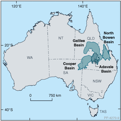
The Australian Government’s Strategic Basin Plans are a key measure under the Gas-fired Recovery agenda. The Strategic Basin Plans identify resource opportunities and the actions needed to accelerate development in identified, strategically important basin locations. To support the Strategic Basin Plans, Geoscience Australia has been engaged by the Department of Industry, Science, Energy and Resources to deliver the Trusted Environmental and Geological Information (TEGI) program. The work is conducted by both Geoscience Australia and CSIRO, commencing in the north Bowen and Galilee Basins and the Cooper and Adavale Basins (Fig. 1). The TEGI program will provide a common evidence base of geological and environmental data and information to assist decision-making in resource development. It will inform government, industry and community users on: resource potential; geological, hydrogeological and environmental systems; and the potential hazards, risks and impacts that must be effectively managed to support resource development in the strategic basin locations.
|
Baseline data repository
The TEGI repository of baseline data and information, for each basin region, supports the program’s environmental and resource assessments across the scope of petroleum, minerals, groundwater, carbon capture and storage, and hydrogen production potential. The repository will become part of a spatial delivery system to deliver regulator-supported data and information for evidence-based decision making. The delivery system will be released during the next program stage.
The Adavale Basin
The Devonian Adavale Basin was selected for initial assessment based on the limited geographic extent and relatively short depositional history of ~60 million years covering the Early to Late Devonian. Thirty-eight (38) petroleum exploration wells have partially or fully penetrated the Adavale Basin, with twenty seven (27) of these intersecting more than one stratigraphic sequence. Two gas accumulations have been recognised in the Adavale Basin – Gilmore and Log Creek (Miyazaki and Ozimic 1987), of which only Gilmore has produced gas commercially. Given the manageable amount of data present in the basin, proven gas-prone petroleum system, large under-explored areas, and the presence of a significant salt body (Boree Salt) which could provide gas, carbon dioxide or hydrogen storage potential, the Adavale Basin presents as an initial basin to be assessed using the TEGI methodology.
A diverse range of depositional environments are identified in the Adavale Basin; from dry alluvial plains to restricted marine embayments. The spatial and temporal interplay between these environments has set up conventional and unconventional hydrocarbon opportunities, along with potential for carbon capture and storage sites, and sites for hydrogen production and storage. Given the presence of gas pipeline infrastructure across the basin, energy resources within the Adavale Basin are well positioned to be brought online if deemed commercially viable.
Resource assessment in the Adavale Basin
The hydrocarbon prospectivity assessments as well as the groundwater, carbon capture and storage and hydrogen storage potential work that is being undertaken for the TEGI program will be integrated into regional multidisciplinary assessments. The work is not designed to be indicative of success or failure on a specific prospect or project. Instead, the resource prospectivity assessments hypothesise the likely locations of future extractive industries and are key prerequisites when prioritising the locations of environmental assessments.
The key play elements in determining the prospectivity of conventional and unconventional hydrocarbon systems for basin assessment in the TEGI program are characterised from both well-based data and existing regional datasets. Play elements include gross depositional environment, reservoir presence and effectiveness, top seal capacity, trap presence, hydrocarbon source quality, depth and hydrocarbon charge. The qualitative play chance for each of these play elements is assessed and spatially plotted over the extent of the assessment area to provide a regional understanding of the potential of the basin. This methodology has been successfully used to characterise the conventional hydrocarbon potential of sedimentary basins (Ferdinando et al. 2019), although it has not been systematically applied to onshore basins within eastern Australia.
To provide increased chronostratigraphic resolution, the stratigraphy is grouped into play intervals, representing key reservoirs and seals of similar age that constrain the hydrocarbon distribution across the basin. This play division is also used to assess the basin on its capacity for carbon capture and storage and potential for hydrogen storage. Each play interval is assessed using every petroleum well that penetrates it.
Conventional hydrocarbon prospectivity play mapping
Initial work on the conventional hydrocarbon play potential of the Adavale Basin divided the Devonian stratigraphy into seven key play intervals: the Buckabie, Etonvale, Cooladdi, Lissoy, Log Creek, Eastwood and Gumbardo sequences. Each of these play intervals represents, where possible, a distinct chronostratigraphic interval.
For each play interval, assessment commences with the interpretation of its gross depositional environments across the basin. This interpretation primarily uses evidence from petroleum exploration wells along with other available data that are stored and analysed in a spatial database using the ArcGIS platform. For example, in the Lissoy Sequence (Fig. 2), two distinct gross depositional environments are interpreted from well data, a dominantly shallow-marine, sand-prone depositional facies (sandy marine shelf – Lissoy Sandstone) and a partially restricted marine carbonate platform and reef depositional facies (shallow marine carbonates – Bury Limestone). In addition to this, areas were identified where either non-deposition or subsequence erosion has occurred or interpreted to be likely.

|
The chance of a prospective reservoir being present across the basin is inferred from the gross depositional environment mapping along with assessment of the penetrated lithologies and, where present, sand thickness for the play interval in each exploration well. From this information, a map showing the qualitative chance of reservoir being present is generated (Fig. 3a). Similarly, by utilising the porosity and permeability data from each play interval within the well-bore along with regional porosity-depth trend data for the sequence, an assessment of the likelihood of finding a reservoir that is capable of flowing hydrocarbons (effective reservoir) is interpreted (Fig. 3b).

|
The methodology established for the conventional hydrocarbon prospectivity of the Adavale Basin is currently being applied to each play element of the other assessment types that are being investigated (tight gas, shale gas, carbon capture and storage, and hydrogen potential) and a composite risk map of the play elements will be generated as a guide for the overall qualitative prospectivity of the basin.
Linking groundwater and hydrocarbon resource assessments
Many of the repository datasets used in the resource assessments, relating to geological architecture, depositional environments and reservoir characteristics, are also used to support basin environmental assessments. These datasets are supplemented by traditional groundwater data such as bore depth, groundwater levels/pressure, hydrogeochemistry, aquifer yield and surface water/groundwater interaction.
Environmental assessment in the Adavale Basin region occurs from the base Adavale Basin through the overlying Galilee, Eromanga and Lake Eyre Basins to the surface, encompassing groundwater, surface water and ecological assets. Prospectivity play mapping undertaken in the program allows focused assessment in areas of potential resource development. For example, there are several highly saline (>300 000 mg/L TDS) aquifers in the Adavale Basin such as the Lissoy Sandstone and Log Creek Formation that could potentially interact with overlying aquifers. Due to geological complexity, these Adavale Basin aquifers may be separated from the fresher aquifers in the Galilee and Eromanga basins by thick, low-permeability units within the Joe Joe Group in the Galilee Basin. However, where the Joe Joe Group is absent or thin, there may be little to no separation between saline and fresh groundwater aquifers. Therefore, understanding the locations of potential resource development allows analysis of the groundwater pathways specific to these basin relationships from the Adavale Basin to overlying aquifers. This helps identify and manage risk to groundwater resources, as well as identify, prioritise and assess surface water resources and environmental matters such as threatened species and protected areas.
Conclusion
Geoscience Australia’s work on the Adavale Basin presents the first example of how the TEGI program is linking resource and environmental assessments. The products from the TEGI program for each assessed basin will include a set of regional-scale maps that characterise the conventional and unconventional energy potential as well as groundwater quality, flow and yield that are intended to be used an evidence base for decision-makers. Through understanding the areas of future resource potential, and providing a data repository of transparent, trusted baseline geological and environmental data, the TEGI program aims to optimise the regulatory pathway while safeguarding environmental protections, increase regulatory efficiency, and accelerate energy resource development in a changing world.
Data availability
Data and publications of the TEGI program will be made available on Geoscience Australia’s Data and Publications Catalogue at www.ga.gov.au and on www.data.gov.au.
Conflicts of interest
The authors declare no conflicts of interest.
Declaration of funding
The Trusted Environmental and Geological Information program is fully funded by the Commonwealth of Australia.
Acknowledgements
The authors acknowledge the contributions of the Trusted Environmental and Geological Information team at Geoscience Australia to the work underpinning this paper. This team, in addition to the authors, comprises Mitchell Bouma, Chris Gouramanis, Diane Jorgensen and Carmine Wainman. The authors would also like to acknowledge staff from our program partners, CSIRO and the Australian Government Department of Industry, Science, Energy and Resources, for their ongoing contributions to the delivery of the technical program. Chris Nicholson and Tehani Palu are thanked for their constructive review. This paper is published with the approval of the CEO, Geoscience Australia, Canberra.
References
Ferdinando DD, Harrison PV, Stanbrook DA (2019) Shooting for the stars: unravelling a Late Jurassic turbidite petroleum system – frontiers for the next generation of exploration. In ‘The Sedimentary Basins of Western Australia V: Proceedings of the Petroleum Exploration Society of Australia Symposium, Perth, WA, 2019’. (Eds M Keep, SJ Moss) p. 19. (Petroleum Exploration Society of Australia: Perth)Miyazaki S, Ozimic S (1987) Australian petroleum accumulations report 4: Adavale Basin, Queensland. Bureau of Mineral Resources, Geology and Geophysics, Canberra.

Dr Sarlae McAlpine is the Director of the Strategic Basins Section in the Advice, Investment Attraction and Analysis Branch in the Minerals, Energy and Groundwater Division at Geoscience Australia. Sarlae has 10 years of experience leading and contributing to pre-competitive geoscience research programs within the Australian Government, and has significant international science engagement experience. Sarlae has held a number of roles at Geoscience Australia, including leading integration and prospectivity in the Mineral Systems Branch, as the inaugural Executive Officer to the CEO, and Director of Digital Earth Africa. Sarlae has a Bachelor of Science (Hons), and PhD in Igneous and Mantle Petrology from the Research School of Earth Sciences, the Australian National University. |

Dr Meredith L. Orr holds a BSc (Hons) from the Australian National University and a PhD in Earth Sciences from the University of Melbourne. She gained 10 years of experience in multidisciplinary research and teaching at Monash University before joining Geoscience Australia. This experience in integrating scientific disciplines informed her contribution to the Australian Government’s Geological and Bioregional Assessments program. Meredith was an Energy Resources Geoscientist at Geoscience Australia and she is currently coordinating the delivery of integrated science in the Trusted Environmental and Geological Information program. |

Dr Darren Ferdinando gained his BSc (Hons) and PhD from the University of Western Australia. He initially worked for the GSWA before moving to explore the Perth Basin with Arc Energy. After a successful period with Arc, he then took up an offer he could not refuse, joining Murphy Oil’s newly opened Australia office and worked across the Browse, Bonaparte and Perth Basins, as well as New Zealand’s offshore basins, the Great Australian Bight and the Vulcan Sub-basin. After Murphy Oil circled the wagons, closed the Perth office and headed back to Houston, he started his own consultancy, Basin Science, which specialises in regional play mapping across Australian Basins. Darren recently joined Geoscience Australia as a Resource Assessment Specialist focusing on play mapping of conventional and unconventional resources over eastern Australian basins. He is a Fellow of PESA and a member of AAPG. |

Stephen Hostetler has a Master’s degree in Geoscience from the University of Wyoming and a Bachelor of Science with Honours in Geoscience from the Pennsylvania State University. He has over 30 years of experience as a hydrogeologist in both the private and public sectors. Professional expertise includes deep groundwater, hydrogeochemistry, surface water/groundwater interaction and groundwater hydrodynamics. He is currently working for Geoscience Australia as a Hydrogeologist within the Trusted Environmental and Geological Information program and is Communications Champion for the ACT Branch of the International Association of Hydrogeologists. |