

The Northwest Offshore Otway Basin Well Folio
Duy Nguyen A * , Dianne S. Edwards A , Merrie-Ellen Gunning A and George Bernardel AA Geoscience Australia, GPO Box 378, Canberra, ACT 2601, Australia.
The APPEA Journal 62 S461-S466 https://doi.org/10.1071/AJ21124
Accepted: 10 March 2022 Published: 13 May 2022
© 2022 The Author(s) (or their employer(s)). Published by CSIRO Publishing on behalf of APPEA. This is an open access article distributed under the Creative Commons Attribution 4.0 International License (CC BY).
Abstract
The Otway Basin is a northwest–southeast trending rift basin which spans from onshore Victoria and South Australia into the deep-water offshore. The prospective supersequences within the basin are largely of Cretaceous age that host three possible petroleum systems (Austral 1, 2 and 3). While there is production from onshore depocentres, and the inboard Shipwreck Trough, the majority of the offshore basin remains underexplored. Recent regional studies have highlighted the need for further work across the underexplored parts of the basin and here we focus on the offshore northwest Otway Basin, integrating reinterpreted historical well data, newly acquired and recently reprocessed seismic data. This new Well Folio consists of composite logs and supporting data, which includes interpreted lithologies, petrophysical analyses, the analysis of historic organic geochemistry and organic petrology. In addition, updated well markers are provided based on seismic interpretation and new biostratigraphy in key wells. This integrated study provides the basis for renewed prospectivity assessment in the northwest offshore portion of the Otway Basin.
Keywords: biostratigraphy, hydrocarbon prospectivity, lithologies, offshore, organic geochemistry, Otway Basin, petrophysical analysis, well data.
Introduction
The northwest trending Otway Basin was formed on the southern Australian passive margin as a result of multi-stage rift-sag and inversion phases throughout the Upper Jurassic and Cretaceous, followed by thermal subsidence and marine transgression during the Cenozoic. Exploration is mature onshore and relatively immature offshore. Commercial gas production and exploration drilling are active in the onshore northern part of the basin, and eastern offshore Otway Basin, within the Shipwreck Trough. In the northwest offshore part of the basin, commercial volumes of hydrocarbons have not yet been discovered where, notably, oil and gas shows are reported in some wells. The main exploration targets for the basin are the Upper Cretaceous Shipwreck Supersequence (Turonian Waarre Sandstone and Santonian Thylacine Sandstone Member), Lower Cretaceous Crayfish Supersequence (Valanginian–Hauterivian sandstones of the Pretty Hill Formation) and locally within the basal Eumeralla Supersequence (Berremian Windermere Sandstone Member, Katnook Sandstone) (Geoscience Australia 2021a).
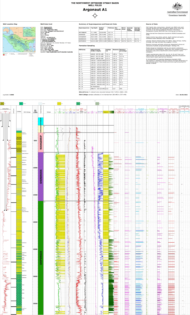
Eleven wells (Fig. 1) are included in the ‘Northwest Offshore Otway Basin Well Folio’ forming part of Geoscience Australia’s regional seismic interpretation and well composite (Fig. 2) summary data release. These new precompetitive data further support the assessment of hydrocarbon prospectivity across the region (Geoscience Australia 2021a, 2021b). In addition to updated stratigraphic well markers and interpreted well lithologies, the Well Folio includes well logs, derivation of shale volume (Vshale), reservoir characterisation, and the integration of historic organic geochemistry and organic petrology results from cutting and core samples.

|
|
Well data
Eleven wells in the northwest offshore Otway Basin, in proximity to the regional seismic interpretation study area, are presented in this Well Folio. Furthermore, the well locations, trajectories, total depths and other well header information are summarised in Table 1.

|
The National Offshore Petroleum Information Management System (NOPIMS, https://www.ga.gov.au/nopims) is the main source for well data. Wireline logs, Logging While Drilling (LWD) logs, sidewall and conventional core lithology, along with significant oil and gas shows, are extracted and presented in this Well Folio. Biostratigraphy datasets were obtained from MGPaleo whose reports include the biostratigraphic zonations and the laboratory analysis of cuttings and sidewall core samples (MGPaleo 2020). To ensure uniformity across wells, geological names from the Australian Stratigraphic Unit Database (Geoscience Australia 2022) were used and geological names from the original data sources were replaced where needed. Organic geochemical data, namely total organic carbon (TOC) and programmed pyrolysis, along with organic petrological data, were compiled by Geoscience Australia using well completion reports and other publicly available laboratory reports.
Well log interpretation
Wireline log data are the main inputs for the petrophysical analysis in this Well Folio. The primary data were calliper (CAL), gamma ray (GR), spontaneous potential (SP), resistivity (IND, LLD, ILD), sonic (DT), density correction (DRHO), density (RHOB) and neutron porosity (TNPH). Schlumberger’s petrophysical analysis software package TechlogTM was used to perform petrophysical analyses and to create the well composites. Gamma ray (GR) logs were primarily used to determine the shale volume (Vshale). Clean sand and shale points were picked based on GR values together with other data, where available, such as density-neutron crossplot and spontaneous potential (SP). Lithology facies information from the various well completion reports were used together with well logs for selecting sand/shale points. Vshale was calculated for shale corrections in the subsequent effective porosity estimates. Subsequently, porosity estimates were analysed from both density (RHOB) and sonic logs (DT) and compared with laboratory core porosity measurements where available. The density log porosity was typically considered to be the best fit with core porosity and was selected as the primary source for effective porosity calculations. The exceptions being the Crayfish Supersequence in Crayfish 1A, and the Shipwreck Supersequence in Argonaut A1, where sonic porosity provided better calibration and hence, are represented in the final effective porosity calculation method. Net reservoir properties, including average shale volume and average effective porosity summaries, are estimated for the deeper supersequence(s) in each well (Table 2). The net reservoir cut-off assumptions are shale volume <40% and effective porosity >10%.

|
Petroleum systems elements
Of the three described Austral Petroleum Supersystems (Bradshaw 1993; Edwards et al. 1999; Boreham et al. 2004), the Austral 2 Lower Cretaceous fluvial and coaly facies of the Eumeralla Supersequence, and Austral 3 Upper Cretaceous to lowest Cenozoic fluvial-deltaic and marine facies mostly within the Shipwreck and Sherbrook supersequences are considered to be the most prospective source rocks in deep-water areas (Schenk et al. 2021). The Well Folio displays the pyrolysis data for each well; however, high S1, high production index (PI), and low Tmax values portray that much of the data are affected by the presence of free hydrocarbons, as shown by the paler coloured bars in Fig. 2. Taking Argonaut A1 as an example, the sample data for this well may show the presence of either migrated hydrocarbons and/or drilling additives. Bearing this in mind, samples with good source potential are present within these aforementioned Cretaceous supersequences.
From this study of wells in the northwest offshore Otway, beyond the more data-rich Shipwreck Trough, the reservoir quality in the Sherbrook Supersequence appears to be fair to good in Argonaut A1, Breaksea Reef 1 ST3 and Voluta 1; although reservoir facies development and charge remains unknown in the deep-water region. The reservoir units within the Shipwreck Supersequence display fair to good net reservoir thickness (with net to gross ranging from 14.8% to 42.9%) and good average porosities (17.7–24.8%) in Argonaut A1, Breaksea Reef 1 ST3, Copa 1 and Morum 1 (Table 2). Having said this, net reservoir development in the Shipwreck Supersequence is low in Voluta 1 (1% net to gross; Table 2) and non-existent in Triton 1 ST1 which intersected tight sandstones/siltstones at the bottom of the well. Average porosity within sandstones in the Eumeralla Supersequence are relatively high (18.8–21.3%) in Chama 1A, Sophia Jane 1 and Troas 1 ST, but with general low net to gross sandstone development in all but Chama 1A which is high at 45.7% (Table 2). Reservoir development within the Crayfish Supersequence (Pretty Hill Formation) is good in Crayfish 1A, Trumpet 1 and Sophia Jane 1 with 17.8%, 18.3% and 23.1% average porosity, respectively, but poor in Troas 1 ST1 (6.9% net to gross and 13.8% average porosity). Although Chama 1A intersected 37 m of Crayfish Supersequence at the base of the well, the interval is majority siltstone with zero net reservoir.
Summary and conclusions
The Northwest Offshore Otway Well Folio presents data from 11 wells enabling the assessment of hydrocarbon prospectivity across this region. The new sequence picks and better understanding of the lithologies and depositional settings will provide valuable input into constraining the regional mapping. It provides well composite logs, organic geochemical data, sequence stratigraphic markers and petrophysical evaluations that form the basis for further studies into reservoir and seal quality along with source rock potential across the northwest region of the Otway Basin.
The Northwest Offshore Otway Basin Well Folio including well composites and data package for key wells will be available on the Geoscience Australia’s Data & Publications website: http://www.ga.gov.au/data-pubs.
Data availability
The data that support this study are available in the National Offshore Petroleum Information Management System (NOPIMS) at http://www.ga.gov.au/nopims.
Conflicts of interest
No conflicts of interest exist between these authors and any other person or organisation.
Declaration of funding
No funding from external organisations was received for this research.
Acknowledgements
We would like to thank Geoscience Australia’s Organic Geochemistry and Isotope Laboratory and the Resource Division Information Management team for provision and management of data. Liuqi Wang and Chris Cubitt are thanked for their constructive reviews. This abstract is published with the permission of the CEO, Geoscience Australia.
References
Boreham CJ, Hope JM, Jackson P, Davenport R, Earl KL, Edwards DS, Logan GA, Krassay AA (2004) Gas-oil-source correlations in the Otway Basin, southern Australia. In ‘Eastern Australasian Basins Symposium II’. Special Publication, 19–22 September 2004. (Eds PJ Boult, DR Johns, SC Lang) pp. 603–627. (Petroleum Exploration Society of Australia: Adelaide)Bradshaw MT (1993) Australian petroleum systems. PESA Journal 21, 43–53.
Edwards DS, Struckmeyer HIM, Bradshaw MT, Skinner JE (1999) Geochemical characteristics of Australia’s southern margin petroleum systems. The APPEA Journal 39, 297–321.
| Geochemical characteristics of Australia’s southern margin petroleum systems.Crossref | GoogleScholarGoogle Scholar |
Geoscience Australia (2021a) Regional geology of the Otway Basin. Geoscience Australia, Canberra. Available at https://www.ga.gov.au/__data/assets/word_doc/0007/87073/Regional-Geology-of-the-Otway-Basin_2021.docx [Accessed 16 February 2022]
Geoscience Australia (2021b) Australia’s energy commodity resources 2021. Geoscience Australia, Canberra. Available at https://www.ga.gov.au/digital-publication/aecr2021 [Accessed 16 February 2022]
Geoscience Australia (2022) Australian stratigraphic units database. Geoscience Australia, Canberra. Available at https://www.ga.gov.au/data-pubs/datastandards/stratigraphic-units [Accessed 16 February 2022].
MGPalaeo (2020) Palynological summary sheets. Available at https://www.mgpalaeo.com.au/otway-basin/ [Accessed 16 February 2022]
Schenk O, Grosjean E, Edwards DS, Boreham CJ, West T (2021) New insights into the deep-water Otway Basin – Part 3: petroleum system modelling. The APPEA Journal 61, 665–672.
| New insights into the deep-water Otway Basin – Part 3: petroleum system modelling.Crossref | GoogleScholarGoogle Scholar |

Duy (Victor) Nguyen is a Senior Petroleum Engineer in Geoscience Australia’s Resources Division, Energy Systems Branch where he is working on the Browse and Roebuck Basins. He holds BE and ME (Petroleum Engineering) degrees from the University of New South Wales. As part of his degrees, Victor researched the techno-economics of CO2 geological sequestration in Australia. Victor has 5 years of oil and gas industrial experience working for Schlumberger in Australia, Malaysia, India, the Middle East and Africa. Since 2009, Victor has worked on the assessment of the CO2 geological storage potential of the Bonaparte, Gippsland and Browse Basins. |

Dianne Edwards is a Senior Petroleum Geochemist in Geoscience Australia’s Resources Division, Energy Systems Branch. Her scientific focus is on defining the petroleum systems of Australia’s petroliferous basins including both conventional and unconventional play types. Dianne received her BSc (Hons) degree in Geology and MSc in Organic Petrology and Organic Geochemistry from the University of Newcastle-upon-Tyne (UK). She was awarded her PhD from the University of Adelaide in 1996. Dianne is a member of PESA. |

Merrie-Ellen Gunning has over 20 years of experience in the Oil and Gas industry where she has performed a diverse range of roles from strategic planning, business development and operations management, to technical roles specialising in geophysics and exploration. Added to this is 5 years of experience in the Aluminium industry across the value chain from extraction, mining bauxite and nepheline, through refining Alumina to smelting. In addition to her extensive knowledge of industry in Australia, her experience has included postings to Indonesia, Norway, the US, Russia and Singapore, and overseeing operations across the world. She has an MBA from Melbourne Business School and a Bachelor of Applied Science in Geology. Merrie-Ellen joined Geoscience Australia in August 2015 and has worked on a wide range of prospectivity and CO2 storage projects, leading the Energy Systems Branch throughout 2017 and is currently Director of Offshore Energy Systems. |

George Bernardel is a Geoscientist in the Offshore Energy Systems Branch in the Minerals, Energy and Groundwater Division of Geoscience Australia. He gained his BSc (Honours) in Geophysics from the University of Sydney in 1986 and joined Geoscience Australia in 1995. His current role is the seismic mapping of Cretaceous–Cenozoic sequences and structure across the offshore Otway Basin. |