

A regional chronostratigraphic framework for play-based resource assessments in the Eromanga Basin
Barry E. Bradshaw A * , Nadege Rollet A , Jeremy Iwanec A and Tom Bernecker AA Geoscience Australia, GPO Box 378, Canberra, ACT 2601, Australia.
The APPEA Journal 62 S392-S399 https://doi.org/10.1071/AJ21097
Accepted: 10 March 2022 Published: 13 May 2022
© 2022 The Author(s) (or their employer(s)). Published by CSIRO Publishing on behalf of APPEA. This is an open access article distributed under the Creative Commons Attribution 4.0 International License (CC BY).
Abstract
Geoscience Australia is undertaking a series of basin-scale assessments to identify the ‘yet-to-find’ resource potential for hydrocarbons, as well as for groundwater resources and carbon capture and storage (CCS) opportunities in central Australia under the Exploring for the Future (EFTF) Program. A play-based exploration approach is being used to systematically evaluate the key risk elements for each resource type through the analysis of drilling results and spatial data to map ‘sweet spots’ for exploration. These assessments aim to reduce the risks and uncertainties for explorers by providing spatially enabled assessments of energy resources and CCS potential. The work will also improve the understanding of existing groundwater resources which may be impacted by future energy resource developments or provide feedstock for future green hydrogen projects. A key requirement for undertaking such play-based resource assessments is to apply a common regional chronostratigraphic framework across all the resource types that link different geological unit nomenclatures through defining the assessed reservoir and seal intervals and their associated sequence stratigraphic surfaces (sequence boundaries, transgressive surfaces and maximum flooding surfaces). A Mesozoic chronostratigraphic framework has been developed for the Eromanga Basin, which defines nine regional play intervals that host the known hydrocarbon and groundwater resources, or represent potential CCS targets. The Mesozoic play framework is now being applied to undertake play-based low-carbon energy resource assessments in the western Eromanga Basin, with initial work focussing on the interpretation and correlation of the nine play intervals in wells for post-drill analysis.
Keywords: carbon capture and storage, chronostratigraphy, conventional hydrocarbons, groundwater, low-carbon energy resources, play mapping, regional play intervals, unconventional hydrocarbons.
Introduction
Australia has abundant energy resources that provide energy security and economic benefits for all Australians. Global demand is now shifting to ‘net-zero’ energy resources to abate the impacts of global climate change associated with greenhouse gas emissions. Continuing our nation’s energy-enabled prosperity requires maintaining an adequate clean energy supply chain into the future. The Australia’s Future Energy Resources (AFER) project is assessing the occurrence and producibility of potential low-carbon energy resources in underexplored regions of central Australia as part of Geoscience Australia’s Exploring for the Future (EFTF) Program.
Unlocking low-carbon energy resources in the central Australian region requires systematically evaluating and mapping the following: the presence; effectiveness; and interconnectivity of key geological elements. These control the distribution of conventional and unconventional petroleum resources. The same elements also enables the evaluation and mapping of potential geological storage intervals as well as deep unallocated groundwater resources for potential ‘green’ hydrogen fuel production. The play-based resource assessment approach used over several decades by the petroleum industry (e.g. Longley and Brown 2016) provides a workflow for assessing multiple sub-surface sediment-hosted resources to ensure future exploration and production provides carbon-neutral energy resources while ensuring minimal impact on allocated groundwater resources. A key requirement for undertaking play-based resource assessments is to develop a chronostratigraphically based geological framework to define the main play intervals. Regional play schemes have been developed and applied over several decades for petroleum explorers in Western Australia (Longley et al. 2002; Marshall and Lang 2013), but have not as yet been readily available for most onshore Australian basins.
This paper presents a chronostratigraphic play scheme that has been developed for low-carbon energy resource assessments in the Eromanga Basin as part of Geoscience Australia’s AFER Project. The regional play scheme has been adapted from a new chronostratigraphically based geological and hydrogeological framework developed as part of Geoscience Australia’s Great Artesian Basin Groundwater Project (Hannaford et al. 2022; Norton and Rollet 2022). Geoscience Australia’s assessment of the status of groundwater in the Great Artesian Basin (Eromanga, Surat and Carpentaria Basins) will continue under Geoscience Australia’s National Groundwater Systems Project (EFTF Program) aiming to support cohesive and sustainable intergenerational water management practices across borders, while equipping government, industry and the community with geoscience data and information to make informed decisions.
Western Eromanga Basin exploration history
The Jurassic–Cretaceous western Eromanga Basin and underlying Permian–Triassic age Pedirka and Simpson Basins in central Australia are underexplored with only 42 petroleum wells and 5 stratigraphic wells drilled since exploration began in the 1950s (Fig. 1), and about 15 000 line kilometres of 2D seismic data acquired across the assessment area covering about 190 000 km2. Exploration initially focussed on conventional petroleum resources during several exploration programs between the 1950s and 1980s. Exploration was rejuvenated with Central Petroleum’s conventional and unconventional drilling program between 2008 and 2010, and continues in the region with several companies focussing on identifying low-carbon energy resources and associated carbon capture and storage (CCS) prospects. The presence of an active petroleum system has been demonstrated by minor oil and condensate recovered from Triassic and Jurassic reservoirs at Poolowanna 1, and identification of residual oil saturations in several wells (Blamore 1, Colson 1 and Simpson 1; Ambrose et al. 2007; Central Petroleum 2008). A key uncertainty for conventional hydrocarbon exploration has been the structural integrity of traps, with most exploration targets defined on sparse, relatively low-quality seismic data, and several previously drilled traps appearing to have been breached during a Cenozoic phase of fault reactivation (Ambrose et al. 2002, 2007). The AFER Project aims to reduce the uncertainty in identifying valid traps for conventional hydrocarbons and geological storage prospects by reprocessing about 3750 line km of seismic data across the western Eromanga Basin (Fig. 1)

|
The western Eromanga Basin forms part of the Great Artesian Basin and hosts important groundwater resources for remote communities in central Australia. Previous groundwater assessments in the western Eromanga region have identified that a major uncertainty regarding the development of any unconventional hydrocarbon resources is the limited understanding of connectivity between aquifers within the stacked Permian, Triassic and Jurassic–Cretaceous Basins (Wohling et al. 2013). The Queensland portion of the Eromanga Basin has previously been evaluated as having high potential for geological storage of CO2 based on the presence of regionally extensive and effective fluvial reservoirs that are effectively sealed by lacustrine and marine shales (Bradshaw et al. 2009). Understanding the CCS potential of the western Eromanga Basin requires the evaluation of the extent to which these high-potential reservoir–seal intervals occur in the assessment area.
Tectonostratigraphic evolution of the Eromanga Basin
The Eromanga Basin is a large Jurassic to Cretaceous age intracratonic basin that extends over an area of more than 1 000 000 km2 across central and eastern Australia. Up to 3000 m of clastic sediments were deposited in three broad basin successions: an Early Jurassic to Early Cretaceous fluvial and lacustrine succession; an Early to mid-Cretaceous marine succession; and a Late Cretaceous fluvial–lacustrine succession (Passmore 1989; Gallagher et al. 2008). The stratigraphic architecture reflects an interplay between the creation of subsidence-controlled accommodation, fluctuations in sediment supply rates and changing sediment provenances (Lang et al. 2001; Cotton et al. 2006). These allocyclic depositional controls were linked to changes in intra-plate stress fields, eustatic sea-level fluctuations and dynamic (mantle-driven) topography during the breakup of Gondwana (Harrington et al. 2019; Young et al. 2021). The stratigraphic architecture of the western Eromanga Basin was initially influenced by regional uplift in the order of 500–800 m over the western Australian continent throughout the Jurassic and Early Cretaceous, which provided a continual influx of fluvial sandstones during deposition of the Algebuckina Sandstone (Struckmeyer and Totterdell 1990; Norvick 2003; Harrington et al. 2019). A rapid increase in subsidence rates, combined with globally high sea levels in the Early Cretaceous, resulted in a marine incursion across much of the Australian continent and deposition of marine sediments across the Eromanga Basin (Gallagher et al. 2008). Open marine and marginal marine sedimentation continued until the Late Cretaceous when the basin returned to non-marine sedimentation during deposition of the Winton Formation before basin closure during an E–W Late Cretaceous compressional event (Cotton et al. 2006; Kulikowski et al. 2021). Rapid deposition of the Late Cretaceous Winton Formation was the critical event for hydrocarbon generation and expulsion from many Permian, Triassic and Jurassic source intervals (Lowe-Young et al. 1997).
Eromanga Basin chronostratigraphic play framework
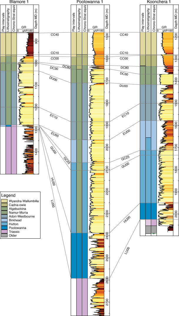
The Eromanga Basin is Australia’s most prolific onshore oil province where it overlies the Cooper Basin in central Australia, with about 215 million barrels of oil produced in South Australia – the majority of oil has been produced from fluvial reservoirs in the Hutton Sandstone and Namur Sandstone (South Australia Department of Energy and Mines 2021). Despite this, there is no published play framework for resource assessments in the Eromanga Basin. Geoscience Australia’s Great Artesian Basin Groundwater Project has recently completed a collaborative study with MGPalaeo and Catherine Jane Norton to refine the chronostratigraphic framework and biostratigraphy of the Great Artesian Basin (Hannaford et al. 2022; Norton and Rollet 2022). The Great Artesian Basin Groundwater Project has compiled a standardised chronostratigraphic framework for the Eromanga, Surat and Carpentaria Basins, which links the lithostratigraphic units from each basin to key regional chronostratigrapic surfaces enabling regional correlations and the mapping of aquifers and aquitards (Fig. 2). These chronostratigraphic surfaces follow the widely adopted hierarchical scheme developed by Santos for exploration in Mesozoic and Cenozoic successions in central Australia (Gallagher et al. 2008; Mackie 2015).

|
The Geoscience Australia and MGPalaeo revised chronostratigraphic framework is applied in this paper to develop a common Mesozoic play framework scheme for assessing sediment-hosted resources in the Eromanga Basin (Fig. 2). The basin succession is sub-divided into nine regional play intervals related to the tectonostratigraphic evolution of the Eromanga Basin. Each play interval represents a regionally significant reservoir and/or seal interval for hydrocarbon accumulations, groundwater systems or CCS intervals. Seven of the eleven play interval boundaries correspond to one of the Santos regional unconformities (designated by ‘U’ in the chronostratigraphic surface nomenclature of Gallagher et al. 2008; Fig. 2). Other play interval boundaries are associated with either regional transgressive or maximum flooding events.
The play interval nomenclature follows a simple system based on the name of the main component stratigraphic units. It was initially hoped that the alpha-numeric play interval scheme developed for the North West Shelf by Longley et al. (2002) and refined in Marshall and Lang (2013) could be applied to the Eromanga Basin, particularly as many of the chronostratigraphic surfaces delineating the Eromanga play intervals appear to correlate to major chronostratigraphic surfaces on the North West Shelf (Fig. 2). However, there is rarely a one-to-one correlation in the play intervals from these two areas. Applying the North West Shelf play interval nomenclature would therefore require both splitting and compounding these established names into a complex naming system that would have little meaning to explorers from either the North West Shelf or central Australia.
Nine play intervals have been interpreted and correlated in well logs across the western part of the Eromanga Basin using chronostratigraphic surfaces picked by Norton and Rollet (2022). The play interval correlations show the transition in Jurassic and Early Cretaceous strata from clearly differentiated fluvial reservoir and fluvial–lacustrine seal intervals in the east to an amalgamated fluvial sandstone succession corresponding to the Algebuckina Sandstone in the west (Fig. 3). A regional seal extends across the western basin area in the marine Wyandra–Wallumbilla play interval. Successful exploration in the western Eromanga Basin requires understanding the spatial extent and effectiveness of these reservoir and seal intervals, and identifying optimal locations where favourable conditions occur for producing sediment-hosted resources or injecting CO2.
|
Conclusions
The western Eromanga Basin is an underexplored area with potential to provide future low-carbon energy resources, CCS and potential hydrogen opportunities. Understanding the region’s low-carbon energy potential requires a play-based exploration approach for resource assessments. Such an approach involves systematically evaluating the presence, effectiveness and connectivity of regional reservoir and seal intervals, and fluid migration pathways for hydrocarbons, groundwater systems and injected CO2 plumes. Geoscience Australia has commenced a play-based resource assessment of this area through integrating post-drill analysis with common risk segment mapping of nine newly defined and interpreted play intervals corresponding to the main reservoir and seal intervals. A Cretaceous and Jurassic chronostratigraphic framework has been developed to support this play-based resource assessment. The chronostratigraphic framework will be expanded in future work to include Permian and Triassic age play intervals for assessing the low-carbon energy resources of the underlying Pedirka and Simpson Basins.
Data availability
Data sharing is not applicable as no new data were generated or analysed during this study.
Conflicts of interest
All authors confirm there are no conflicts of interest.
Declaration of funding
No funding from external organisations was received for this research.
Acknowledgements
The authors wish to thank Darren Fedinando and Carmine Wainman for their constructive reviews, and Catherine Jane Norton, Carey Hannaford and Silvio Mezzomo for figure drafting. The authors also wish to acknowledge the contributions of the Northern Territory Geological Survey and South Australian Department of Energy and Mines as part of the Australia’s Future Energy Resource Project. This paper is published with the permission of the CEO, Geoscience Australia.
References
Ambrose GJ, Liu K, Deighton I, Eadington PJ, Boreham CJ (2002) New petroleum models in the Pedirka Basin, Northern Territory, Australia. The APPEA Journal 42, 259–286.| New petroleum models in the Pedirka Basin, Northern Territory, Australia.Crossref | GoogleScholarGoogle Scholar |
Ambrose G, Scardigno M, Hill AJ (2007) Petroleum geology of the Middle–Late Triassic and Early Jurassic sequences in the Simpson Basin and northern Eromanga Basin of central Australia. The APPEA Journal 47, 127–143.
| Petroleum geology of the Middle–Late Triassic and Early Jurassic sequences in the Simpson Basin and northern Eromanga Basin of central Australia.Crossref | GoogleScholarGoogle Scholar |
Bradshaw BE, Spencer LK, Lahtinen AC, Khider K, Ryan DJ, Colwell JB, Chirinos A, Bradshaw J (2009) Queensland geological storage atlas. Compiled by Greenhouse Gas Storage Solutions on behalf of Queensland Department of Employment, Economic Development and Innovation. Available at https://geoscience.data.qld.gov.au/dataset/ds000035
Central Petroleum (2008) Blamore 1 well completion report, EP 93, Pedirka Basin, Northern Territory. Northern Territory Geological Survey, Open File Petroleum Report PR2009-0152. Central Petroleum Limited.
Cotton TB, Scardigno MF, Boult PJ (2006) Chapter 7: Sequence stratigraphy. In ‘The Petroleum Geology of South Australia, Vol. 2: Eromanga Basin, 2nd Edition, South Australia’. (Eds TB Cotton, MF Scardigno, JE Hibburt) pp. 1–11. (Department of Primary Industries and Resources)
Gallagher SM, Wood GR, Lemon NL (2008) Birkhead Formation chronostratigraphy on the Murteree Horst, South Australia: identifying and correlating reservoirs and seals. In ‘Proceedings of the Petroleum Exploration Society of Australia Symposium. Eastern Australasian Basins Symposium III, 14–17 September 2008’. (Eds JE Blevin, BE Bradshaw, C Uruski) pp. 169–190. (Petroleum Exploration Society of Australia: Sydney).
Gradstein FM, Ogg JG, Schmitz M, Ogg G (2020) ‘Geological time scale 2020.’ pp. 1–1390. (Elsevier)
Hannaford C, Young M, Watts C, Charles A, Cooling J, Rollet N (2022) Palynological review of selected wells and new sampling results in the Great Artesian Basin. Data package and supplementary reports. Record 2022/01. Geoscience Australia, Canberra. Available at http://pid.geoscience.gov.au/dataset/ga/145820
Harrington L, Zahirovic S, Salles T, Braz C, Müller RD (2019) Tectonic, geodynamic and surface processes driving forces of Australia’s paleogeography since the Jurassic. In ‘Proceedings of the Petroleum Exploration Society of Australia Symposium. The Sedimentary Basins of Western Australian V, 2019’. (Eds M Keep, SJ Moss) pp. 1–29. (Petroleum Exploration Society of Australia: Perth, WA)
Helby R, Morgan R, Partridge AD (1987) A palynological zonation of the Australian Mesozoic. In: Studies in Australian Mesozoic Palynology. (Ed. PA Jell). Association of Australasian Paleontologists Memoir, 4, 1–85.
Kulikowski D, Amrouch K, Pokalai S, Mackie SI, Gray ME, Burgin HB (2021) The Cooper-Eromanga petroleum province, Australia. Australian Journal of Earth Sciences 69, 153–187.
| The Cooper-Eromanga petroleum province, Australia.Crossref | GoogleScholarGoogle Scholar |
Lang SC, Grech P, Root R, Hill A, Harrison D (2001) The application of sequence stratigraphy to exploration and reservoir development in the Cooper-Eromanga-Bowen-Surat basin system. The APPEA Journal 41, 223–250.
| The application of sequence stratigraphy to exploration and reservoir development in the Cooper-Eromanga-Bowen-Surat basin system.Crossref | GoogleScholarGoogle Scholar |
Longley IM, Brown J (2016) Why bother? (with play based exploration): the five reasons why play based exploration is worthwhile in a modern busy understaffed and overworked exploration company environment. Oral presentation given at AAPG/SEG International Conference and Exhibition, Melbourne, 13-16 September 2015. AAPG Search and Discovery Article, 110227. (AAPG). Available at https://www.searchanddiscovery.com/pdfz/documents/2016/110227longley/ndx_longley.pdf.html
Longley IM, Buessenschuett C, Cylsdale L, Cubitt CJ, Davis RC, Johnson MK, Marshall NG, Murray AP, Somerville R, Spry TB, Thompon NB (2002) The North West Shelf of Australia — a Woodside perspective. In ‘Proceedings of the Petroleum Exploration Society of Australia Symposium. The Sedimentary Basins of Western Australia 3, 20–23 October 2002’. (Eds SJ Moss, M Keep) pp. 1–32. (Petroleum Exploration Society of Australia: Perth, WA)
Lowe-Young BS, Mackie SI, Heath RS (1997) The Cooper-Eromanga petroleum system, Australia: investigation of essential elements and processes. In ‘Proceedings of the Petroleum Systems of SE Asia and Australasia Conference, May 1997’. (Eds JYC Howes, RA Noble) pp. 199–211. (AAPG).
Mackie S (2015) History of petroleum exploration and development in the Cooper and Eromanga Basins. AAPG Search and Discovery Article, 10814. (AAPG).
Marshall NG, Lang SC (2013) A new sequence stratigraphic framework for the North West Shelf, Australia. In ‘Proceedings of the Petroleum Exploration Society of Australia Symposium. The Sedimentary Basins of Western Australia 4, 18–21 August 2013’. (Eds M Keep, SJ Moss) pp. 27–88. (Petroleum Exploration Society of Australia: Perth, WA)
Norton CJ, Rollet N (2022) Regional structural correlation transects across the Great Artesian Basin – Eromanga and Surat Basin focus study. Record 2022/02. Geoscience Australia, Canberra. Available at http://pid.geoscience.gov.au/dataset/ga/145819
Norvick M (2003) New palaeogeographic maps of the northern margins of the Australian plate: updated report. Unpublished report for Geoscience Australia, September 2003, 53 pp. Available at https://dev.ecat.ga.gov.au/geonetwork/srv/api/records/82539
Partridge AD (2006) Jurassic–Early Cretaceous spore-pollen and dicocyst zonations for Australia. In ‘Australian Mesozoic and Cenozoic Palynology Zonations — Updated to the 2004 Geologic Time Scale’. (Ed. E Monteil). Record 2006/23. (Geoscience Australia: Canberra)
Passmore VL (1989) Petroleum accumulations of the Eromanga Basin: a comparison with other Australian Mesozoic accumulations. In ‘Proceedings of the Petroleum Exploration Society of Australia. The Cooper and Eromanga Basins, Australia, 1989’. (Ed. BL O’Neil) pp. 371–389. (Petroleum Exploration Society of Australia)
Price PL (1997) Permian to Jurassic palynostratigraphic nomenclature of the Bowen and Surat basins. In The Surat and Bowen Basins, Southeast Queensland. (Ed. P Green) pp. 137–178. (Queensland Department of Mines and Energy: Brisbane)
South Australia Department of Energy and Mines (2021) PEPS South Australia (for well data). Available at https://www.petroleum.sa.gov.au/data-centre/online-databases/PEPS-South-Australia
Struckmeyer HIM, Totterdell JM (1990) ‘Australia: Evolution of a Continent. Bureau of Mineral Resources, Geology and Geophysics.’ p. 97. (Australian Government Publishing Service)
Wohling, D, Keppel M, Fulton S, Costar A, Sampson L, Berens V (2013) Australian Government initiative on coal seam gas and large coal mining — Arckaringa Basin and Pedirka Basin Groundwater Assessment Projects. DEWNR Technical Report 2013/11, Government of South Australia, through Department of Environment, Water and Natural Resources (Department of Environment, Water and Natural Resources: Adelaide).
Young A, Flament N, Hall L, Medith A (2021) of mantle flow on intracontinental basins: three examples from Australia. Basin Research 33, 1429–1453.
| of mantle flow on intracontinental basins: three examples from Australia.Crossref | GoogleScholarGoogle Scholar |

Dr Barry Bradshaw is a Geoscientist with over 30 years experience undertaking geological and geophysical studies and play-based prospectivity studies for conventional and unconventional hydrocarbon resources, geological storage projects, and sediment-hosted mineral deposits. Barry is currently employed as the Energy Resources and Advice activity leader at Geoscience Australia, and has previously worked as a Principal Geologist at CGSS consultants, Senior Research Scientist at AGSO/Geoscience Australia and Research Scientist at Texas A&M University (USA). Barry graduated from the University of Sydney in 1988, and completed a PhD in Earth Sciences at the University of Waikato (New Zealand) in 1991. |

Nadege Rollet is a Geoscientist with over 20 years of geoscience research and application experience who graduated from the University of Paris – Pierre et Marie Curie, France where she obtained a MSc and a PhD in Geology and Geophysics. Her studies focused on structural framework and geodynamic of the Ligurian Sea, Western Mediterranean. Since joining Geoscience Australia, she contributed to assessments of the petroleum prospectivity, seepage studies, CO2 storage, hydrogen, groundwater and cover mapping of Australian sedimentary basins. Nadege is currently investigating depositional framework and groundwater systems in the Great Artesian Basin. |

Jeremy Iwanec is a Geoscientist with over 15 years of petroleum industry experience identifying, maturing and delivering exploration, appraisal and development opportunities. Jeremy completed a BSc (Honours) in Applied Geology from the University of New South Wales in 2002, before joining Oil Search Limited in 2003. At Oil Search, he worked on various projects across onshore and offshore Papua New Guinea, Yemen and Kurdistan, undertaking play-based exploration studies, 2D and 3D seismic interpretation, structural and stratigraphic modelling, well planning and delivery, and resource assessments. In 2021, Jeremy joined Geoscience Australia as an Energy Resource Geoscientist where he is currently conducting geological and geophysical studies to assess Australia’s conventional and unconventional hydrocarbon resources and carbon capture and storage potential. |

Dr Thomas (Tom) Bernecker is a sedimentologist/petroleum geologist who holds an MSc from the University of Aachen (RWTH), Germany and a PhD from Melbourne’s La Trobe University. His research work focussed on the development of models for siliciclastic and carbonate depositional systems in NW Europe and in Australia. After a lectureship at the University of Melbourne, Tom joined the Victorian Department of Natural Resources and Energy where his work was focused on the hydrocarbon prospectivity of the Gippsland and Otway Basins. Tom joined Geoscience Australia as the team leader for the onshore hydrocarbon project in 2007 and from 2009 onwards has managed the offshore acreage release program, including the promotion of investment opportunities in Australia’s oil and gas sector. Tom is currently the Director of the Energy Resources Advice and Promotion section in GA’s Minerals, Energy and Groundwater division. He is a member of PESA, SEPM and SEAPEX. |