

Petrophysical characterisation of the Neoproterozoic and Cambrian successions in the Officer Basin
Liuqi Wang A * , Adam H. E. Bailey A , Lidena K. Carr A , Dianne S. Edwards A , Kamal Khider A , Jade Anderson A , Christopher J. Boreham A , Chris Southby A , David N. Dewhurst B , Lionel Esteban B , Stuart Munday C and Paul A. Henson AA Geoscience Australia, GPO Box 378, Canberra, ACT 2601, Australia.
B CSIRO Energy, Perth, WA 6151, Australia.
C Chemostrat Australia, Perth, WA 6005, Australia.
The APPEA Journal 62(1) 381-399 https://doi.org/10.1071/AJ21076
Submitted: 20 January 2022 Accepted: 28 February 2022 Published: 13 May 2022
© 2022 The Author(s) (or their employer(s)). Published by CSIRO Publishing on behalf of APPEA. This is an open access article distributed under the Creative Commons Attribution 4.0 International License (CC BY).
Abstract
The Neoproterozoic–Paleozoic Officer Basin, located in South Australia and Western Australia, remains a frontier basin for energy exploration, with significant uncertainty due to a paucity of data. As part of Geoscience Australia’s Exploring for the Future (EFTF) program, the objective of this study is to derive the petrophysical properties and to characterise potential reservoirs in the Neoproterozoic–Cambrian sedimentary succession in the Officer Basin through laboratory testing and well log interpretation using both conventional and neural network methods. Laboratory measurements of 41 legacy core samples provide the relationships between gas permeability, Klinkenberg corrected permeability, and nano-scale permeability, as well as grain density, effective and total porosity for various rock types. Conventional log interpretation generates the volume fraction of shale, effective and total porosity from gamma ray and lithology logs. A self-organising map (SOM) was used to cluster the well log data to generate petrophysical group/class index and probability profiles for different classes. Neural network technology was employed to approximate porosity and permeability from logs, conventional interpretation results and class index from SOM modelling. The Neoproterozoic−Cambrian successions have the potential to host both conventional and tight hydrocarbon reservoirs. Neoproterozoic successions are demonstrated to host mainly tight reservoirs with the range in average porosity and geometric mean permeability of 4.77–6.39% and 0.00087–0.01307 mD, respectively, in the different sequences. The range in average porosity and geometric mean permeability of the potential Cambrian conventional reservoirs is 14.54−26.38% and 0.341−103.68 mD, respectively. The Neoproterozoic shales have favourable sealing capacities. This work updates the knowledge of rock properties to further the evaluation of the resource potential of the Officer Basin.
Keywords: Cambrian, characterisation, Exploring for the Future, laboratory measurement, log interpretation, Neoproterozoic, neural network, Officer Basin, permeability, porosity, reservoir, seal.
Introduction
The Neoproterozoic–Paleozoic Officer Basin is a remnant of the Centralian Superbasin. It spans 525 000 km2 across southeastern Western Australia and western South Australia (Fig. 1), with its present-day margins bounded by the Yilgarn Craton to the west, Musgrave Block to the north and Gawler Craton to the southeast (Morton and Drexel 1997; Grey et al. 2005). The Officer Basin remains a frontier basin for energy exploration, with significant uncertainty due to a lack of available data (Hashimoto et al. 2018). The stratigraphic architecture of the Officer Basin is poorly constrained, particularly due to limited biostratigraphic control in both the western and eastern Officer Basin (Morton and Drexel 1997; Apak and Moors 2001).

|
As part of Geoscience Australia’s Exploring for the Future (EFTF) program, a new chemostratigraphic framework was developed utilising elemental data obtained using Inductively Coupled Plasma-Optical Emission Spectrometry and Inductively Coupled Plasma-Mass Spectrometry testing by Chemostrat Australia on 1245 cuttings and 241 core samples from 10 Officer Basin wells (Munday et al. 2021). The five wells from the Western Australia area include Dragoon 1, Hussar 1, Geological Survey of Western Australia (GSWA) Vines 1, Lungkarta 1/ST1, and the five wells from the South Australia region include Birksgate 1, Giles 1, Kutjara 1, Mulyawara 1 and Trainor Echo 1 (Fig. 1). Key elements and ratios, which typically have the best correlation potential over a greater distance, were selected to subdivide the strata and highlight changes in sediment provenance, as well as to identify climatic and organic matter changes.
In Munday et al. (2021), five chemostratigraphic mega-sequences (MS1–MS5) were defined, predominantly in the Neoproterozoic and Cambrian successions of the Officer Basin. MS1–MS3 broadly correspond to the Neoproterozoic Centralian Supersequence (CS1–CS3) as defined by Bradshaw et al. (2021). MS4 corresponds to the Cambrian CS4 (Bradshaw et al. 2021) and includes most of the Marla Group (Khider et al. 2021; Munday et al. 2021). Each MS has a different number of sequences, dependent upon the variability in their chemical composition. These MSs, sequences and their corresponding stratigraphic units are shown in Fig. 2, incorporating the lithostratigraphy after Apak and Moors (2001), Apak and Carlsen (2003), Haines et al. (2008) and Khider et al. (2021) as follows:
MS1 has 11 sequences (MS1-S0–MS1-S10), corresponding to the Pindyin Sandstone and the Alinya, Browne, Hussar and Kanpa formations.
MS2 has three sequences (MS2-S1–MS2-S3), corresponding to the Pirrilyunka Formation in GSWA Vines 1.
MS3 has seven sequences (MS3-S0–MS3-S6), corresponding to the Wahlgu and Meramangye formations, Tarlina Sandstone, Murnaroo Formation, Dey Dey Mudstone, Karlaya Limestone, and Tanana, Munyarai and Narana formations.
MS4 has five sequences (MS4-S1–MS4-S5), corresponding to the Relief Sandstone, Observatory Hill Formation, Arcoeillinna Sandstone, and Apamurra and Lungkarta formations.
MS5 corresponds to the upper part of the Cambrian Trainor Hill Sandstone (Marla Group) in Trainor Echo 1 and the Table Hill Volcanics in Yowalga 3.

|
The stratigraphic columns of the Neoproterozoic–Cambrian successions have been updated after Khider et al. (2021), Haines et al. (2008), Bradshaw et al. (2021) and Hashimoto et al. (2018) and integrate the new chemostratigraphic MSs and sequences of the 10 Officer Basin wells (Munday et al. 2021).
In the current study, petrophysical properties are analysed through laboratory testing, as well as analysis and interpretation of well logging data covering the Neoproterozoic and Cambrian successions from MS1 to MS4 in six selected Officer Basin wells: Birksgate 1 (Henderson and Tauer 1967), Giles 1 (Dunster 1986), GSWA Vines 1 (Apak et al. 2001), Munta 1 (Cucuzza 1987), Yowalga 3 (Shell Development (Australia) Pty Ltd 1981) and Hussar 1 (Karajas and Yaylor 1983). Some of these wells feature gas indications in mud-logging data and host other minor hydrocarbon indications (Fig. 1). For example, in Birksgate 1, the laboratory measured water saturation from cores range from 25 to 77% in MS4, and yellow spots of crude oil were observed on cores (Henderson and Tauer 1967). Petrophysical characterisations are reported following the chemostratigraphic MSs and sequences interpreted by Munday et al. (2021), which are placed within the stratigraphic framework of Khider et al. (2021).
Laboratory testing
Apak and Moors (2001) presented potential conventional reservoirs and their sedimentary and diagenetic genesis of the Neoproterozoic−Paleozoic successions in the Lennis area of the Officer Basin, based on laboratory measured porosity and permeability, and log-derived porosity. As part of the EFTF program, 41 legacy core samples were collected from 5 (Table 1) of the 6 wells analysed for testing of petrophysical properties.
|
The samples listed in Table 1 represent a range of lithotypes and were analysed and tested in CSIRO’s laboratory to derive a variety of petrophysical properties of conventional, tight and shale reservoir rocks. The analyses and tests included:
Core imaging (scanning and digital photography) through medical X-ray Computerised Tomography to identify general texture and internal microstructure and to derive dry bulk density.
Gas porosity and permeability testing on dry core plugs using a CoreTest Inc. automated nitrogen Permeameter–Porosimeter for samples with permeabilities greater than 1 µD.
Unsteady state pulse decay testing using a CoreTest Inc. NDL-605 apparatus for ultra-low permeability samples (11 samples with permeabilities of less than 1 µD).
Grain density measured from powders (ground from dry core plugs) with a helium gas displacement pycnometer (Accupyc II 1340, Micrometritics).
Mercury injection capillary pressure (MICP) analysis of select samples.
The average laboratory measured total porosity of conventional, tight and shale reservoir rocks is 17.79, 7.09 and 5.38%, respectively, and geometric mean permeability is 5.63, 0.00135, and 0.00048 mD, respectively (Bailey et al. 2021). The average measured gas (nitrogen) porosity of tight and shale reservoir rocks is 2.26 and 1.07%, respectively. Table 2 presents the average petrophysical parameters of various rock types in the Neoproterozoic and Cambrian successions. Further details, and all results, from the testing program are presented in Bailey et al. (2021). Fig. 3 presents the relationships between air-permeability, corrected permeability after removing slippage effect (Klinkenberg correction) and correction from gas permeability to nano-scale permeability testing results.

|

|
Alongside newly acquired laboratory measurements, previously conducted laboratory measurements of petrophysical properties were collated. These were mainly sourced from the well completion reports of the six selected wells (Fig. 1). Laboratory measurements sourced from these well completion reports primarily include grain density, porosity and air permeability, with porosity having been tested mainly using helium gas expansion methods (Ahmed 2002; Yu 2013). In this study, the relationships summarised in Fig. 3 were used to correct the gas permeability for conventional, tight and shale reservoir rocks. The newly acquired and previously measured laboratory data provide a combined dataset of 193 effective porosity and 177 permeability measurements, which were used as training targets for neural network interpretations.
Well log interpretation
Well logging data
Legacy well logging data were obtained from the Western Australia Petroleum and Information Management System (WAPIMS 2021) for the wells in the western Officer Basin and from the South Australian Resources Information Gateway (PEPS 2021; SARIG 2021) for the wells in the eastern Officer Basin. Well logging data were acquired by Schlumberger in Yowalga 3; Reeves/BPB in Hussar 1, Giles 1, and GSWA Vines 1; Welex in Birksgate 1; and Geoscience Associates (Australia) in Munta 1.
Birksgate 1 has gamma ray, compressional wave slowness, neutron and resistivity logs, but no bulk density log. Bulk density for this well was approximated from compressional wave slowness using Brocher’s polynomial model (Gardner et al. 1974; Brocher 2005). The remaining five wells have gamma ray, compressional wave slowness, neutron porosity and bulk density logs. Selecting a method for interpreting wireline logs depends on data availability and quality. Other well data, such as formation temperature, drillstem testing, organic and inorganic geochemical data, and mud properties, were collected from the relevant well completion reports held by WAPIMS (2021) and the South Australian Resource Information Gateway (SARIG 2021). In this study, well log data interpretation is performed by combining conventional and neural network interpretations.
Volume fraction of shale and effective porosity
After data collection and pre-processing, conventional interpretation was conducted in Schlumberger’s TechlogTM platform. The volume fraction of shale (Vshale) was interpreted from gamma ray logs using the Larionov model (Schlumberger 1991) and neutron-density crossplots. Effective and total porosity were computed from compressional wave slowness in Birksgate 1 and from compressional wave slowness and neutron-density crossplots in the remaining five wells (Schlumberger 1991, 2003; Ellis and Singer 2007; Wang et al. 2021). The interpretation intervals were defined in reference to the chemostratigraphic sequences for the Neoproterozoic−Cambrian sedimentary succession defined in Munday et al. (2021).
Clustering with a self-organising map (SOM)
Unsupervised machine learning algorithms, such as the K-means and Gaussian mixture model, SOM and many others, have been used for lithofacies identification (Balashov et al. 2019; Saputelli et al. 2019; Celma et al. 2020). As a neural network tool, SOM is used to classify multivariate data samples into petrophysical groups or classes using unsupervised learning. Compared to classic clustering algorithms, SOM provides the management of transitions between classes, which is important in analysing geological questions. In this study, SOM clustering was performed to define 10 petrophysical groups or classes using the Ipsom module in Schlumberger’s TechlogTM platform, and utilising gamma ray, compressional wave slowness, bulk density, neutron porosity, interpreted Vshale, effective and total porosity. During the SOM modelling, hierarchical clustering with Ward’s method was used to cluster the input parameters. The petrophysical classes are then sorted by effective porosity and ordered from minimum to maximum porosity.
The outputs from SOM clustering include class indexes (1–10), and probability profiles so that the data samples belong to different classes (Columns 10–11, Figs 4, 5). The SOM classes present the clustered petrophysical groups, and the class index indicates the groups with different petrophysical property ranges. The cumulated class profiles provide another dataset for lithostratigraphic correlation between wells. Figs 4, 5 present the input logs and interpretation results from conventional methods, SOM modelling and neural network interpretation results. Neural network interpretation will be discussed in the next section.

|

|
Interpretation with artificial neural networks (ANNs)
Permeability is a key parameter for reservoir characterisation, as it is critical for analysis of fluid flow and production performance. Empirical, linear, simple non-linear equations or regression models have been proposed for permeability interpretation from well logs (Schlumberger 1991; Asquith and Krygowski 2004). However, it is difficult to estimate permeability from multiple input logs because of the complex relations between permeability and various logs, especially where the lithological types are complex, as is the case for the Neoproterozoic–Cambrian succession in the Officer Basin. The logarithmic permeability derived from gamma ray, compressional wave slowness, bulk density, neutron porosity, interpreted Vshale, effective and total porosity, and petrophysical class index using multivariate linear regression has the correlation coefficient (R2) of 0.3645 with the laboratory measurements. An ANN approach was used to learn the underlying correlations between the input parameters and laboratory measurements and to improve the approximation of permeability in this study.
ANNs
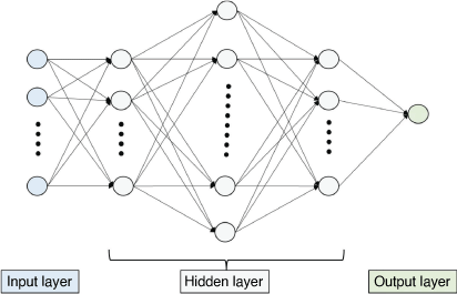
ANNs have been used to solve a wide variety of tasks (Hopfield 1985; Hect-Nielsen 1990; Kalogirou 2000). In the petroleum domain, ANNs have been applied in estimating hard data, such as laboratory measurements, from seismic attributes, well logs and conceptual geological descriptions (Wong et al. 1995; Wang et al. 1999, 2021; Huang et al. 2001; Yan et al. 2014; Ouadfeul and Aliouane 2015; Julian 2016; Saputelli et al. 2019). Fig. 6 presents an example of an architecture of a neural network with input, output and three hidden layers. Each layer has different numbers of neurons.
|
The input layer imports the input parameters, the input of each neuron in hidden and output layers is a linear combination of neuron outputs in the former layer, and the output neuron gives the output parameter. Activation functions, such as rectified linear unit (ReLU), sigmoid and hyperbolic tangent functions, are used to transform input to output at each hidden neuron. A loss (error) function is constructed by comparing to the targets (laboratory measurements). During the neural learning process, the weights connecting neurons are updated using batch gradient descent or stochastic gradient descent algorithms. As a popularly used optimiser, adaptive momentum estimation (Adam) enables us to compute adaptive learning rates and avoid oscillations during optimisation by accelerating the descent in the right direction (Kingma and Ba 2015; Selvam 2018; Brownlee 2019; Stewart 2019). A variety of hyperparameters need to be configured for neural network learning, such as the number of hidden layers and neurons, as well as the selection of an activation function (Avila and Hauck 2017; Brownlee 2019). Sensitivity analysis is performed for optimisation purposes using the root mean square error, the mean absolute error and the correlation coefficient (R2) between approximations and targets.
Porosity and permeability interpretation
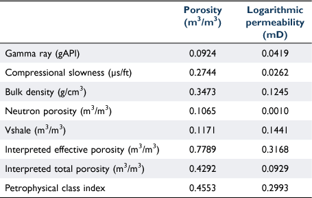
In this study, the input parameters include a series of selected well logs (gamma ray, compressive wave slowness, bulk density and neutron porosity), interpreted Vshale, effective and total porosity using conventional methods, and SOM clustered petrophysical class index. Table 3 presents the R2 between the input parameters and laboratory measured porosity and permeability in the six selected wells. The lithology logs, interpreted effective and total porosity, and petrophysical class index have higher R2 with the laboratory measured porosity than the remaining input parameters. The bulk density, interpreted Vshale and porosity, and petrophysical class index are better correlated with the logarithmic permeability than other input parameters.
|
A total of 193 and 177 training patterns were constructed for porosity and permeability interpretations, respectively. One single output parameter is either porosity or permeability (Fig. 6). The input logs were standardised among the six wells using the medians of logs in the halite and shale intervals within the same sequence. All the input parameters were normalised to be within the range of [−1, 1] before neural network learning.
Results
The optimal neural network architecture for each porosity and permeability estimations has three hidden layers with 20, 200 and 20 hidden neurons based on sensitivity analysis. ReLU was selected as the activation function, and the Adam algorithm was used during the neural learning processes for both porosity and permeability estimations. The R2 between the laboratory measured and neural network interpreted effective porosity and permeability (Columns 8–9, Figs 4, 5) are 0.7912 and 0.7167, respectively. The neural network interpreted porosity is slightly better correlated with target porosity than the porosity from conventional interpretations in Table 3. Compared to the permeability estimation results from multivariate linear regression, the neural network approach is capable of handling the complexity inside petrophysical data and of deriving the approximations with a significantly higher R2 with targets. The interpreted porosity and permeability are summarised for different chemostratigraphic sequences and various reservoir types in the following section.
Petrophysical characterisation
A variety of potential reservoirs and seals have been previously identified in the Neoproterozoic and Cambrian successions of the Officer Basin (Walter and Gorter 1994; Zang 1995; Morton and Drexel 1997; Apak and Moors 2001; Apak and Carlsen 2003; Tingate and McKirdy 2003; Samson 2018). This study focuses on the descriptions of Vshale, porosity and permeability distributions for reservoirs and seals of the six selected Officer Basin wells (Fig. 1). The sedimentary rocks are investigated by integrating laboratory measurements and well log interpretations for conventional, tight and shale reservoir rocks. The three reservoir types are defined using the following cutoffs on the volume fraction of shale (Vshale, Column 7, Figs 4, 5), neural network interpreted porosity (PORNN, Column 8, Figs 4, 5) and permeability (PERMNN, Column 9, Figs 4, 5):
Conventional reservoir rock: Vshale <0.5; porosity ≥0.1 and permeability ≥0.1 mD
Tight reservoir rock: Vshale <0.6; permeability <0.1 mD
Shale: Vshale ≥0.6.
Figs 7–9 present the distributions of Vshale, effective porosity and permeability of various presented sequences from MS1 to MS4 in the six selected wells in this study. The three potential reservoir types are present in both the western and eastern Officer Basin, apparent where multiple peaks appear in the distribution histograms (Figs 7–9). The distribution of petrophysical properties implies the potential for forming different types of reservoirs.

|

|

|
Table 4 lists the ratios of conventional and tight reservoirs (reservoir thickness over gross thickness), average Vshale and effective porosity, and geometric mean permeability of each MS (MS1–MS4). Table 5 presents the average Vshale and porosity, and geometric mean of permeability of potential conventional and tight reservoirs in each MS in the six selected wells. Besides the conventional and tight reservoirs, the laboratory measured total porosity of the Cambrian shales range from 8.27 to 12.86% with an average of 5.38%, whereas the total porosity ranges from 1.76 to 6.33% with an average of 4.13% in the Neoproterozoic shales (Bailey et al. 2021). The further study on reservoir potential includes the evaluations on, but not limited to, the organic matter richness of source rocks and thermal maturity, hydrocarbon migration, brittleness of shales and geomechanical properties.

|

|
MS1
MS1 was deposited in a large thermal sag basin initiated in the early Neoproterozoic (late Tonian), and the sedimentary build-up was controlled by northwest–southeast extension (Morton and Drexel 1997; Apak and Moors 2001; Apak and Carlsen 2003; Tingate and McKirdy 2003; Boult and Rankin 2004; Bradshaw et al. 2021; Khider et al. 2021). The sequences include MS1-S2–MS1-S9 in Yowalga 3, MS1-S5–MS1-S10 in Hussar 1, and MS1-S0 and MS1-S2 in Giles 1. The sedimentary rocks of MS1 have been correlated to the Pindyin Sandstone, and Alinya, Browne, Hussar and Kanpa formations (Fig. 2) that comprise clastic, carbonate and evaporites inferred to have been deposited in a sabkha environment.
MS1 is interpreted to be a predominantly tight reservoir in Yowalga 3 and Giles 1, with a small portion (less than 20%) interpreted as A conventional reservoir in Hussar 1. The range in the average porosity and geometric mean permeability of the interpreted tight reservoirs are 5.7−6.39% and 0.00087−0.01307 mD, respectively, in the different MS1 sequences. The interpreted conventional reservoirs in the study wells show a range in average porosity and geometric mean permeability of 12.34−16.02% and 3.851−29.391 mD, respectively, in the MS1 sequences.
MS2
MS2 was identified only within GSWA Vines 1 by Munday et al. (2021) and corresponds to the Pirrilyungka Formation in Haines et al. (2008) (Fig. 2). MS2 is characterised by dolomitic clastics (massive sandstone, diamictite and shaly diamictite) and deposition ranging from mass flow in deep marine environments; to glacigene, shallow marine; to continental, pebbly outwash deposits in the GSWA Vines 1 area. MS2 has three sequences (MS2-S1–MS2-S3, Munday et al. 2021). A broad correlation can be seen within the geochemistry and the sedimentological subdivisions defined by Haines et al. (2008). MS2 mainly hosts tight reservoirs, with an average porosity and geometric mean permeability of 4.77% and 0.00139 mD, respectively.
MS3
MS3 broadly corresponds to the lithostratigraphy from the Tarlina Sandstone to the Tanana Formation, although this does vary depending on the lithostratigraphic nomenclature used within each well (Fig. 2). This MS is recognised predominantly within the eastern wells (Munday et al. 2021), including MS3-S1–MS3-S6 in Giles 1, MS3-S5 in Birksgate 1, and MS3-S4–MS3-S6 in Munta 1. This MS mainly consists of fluvial-deltaic-lacustrine massive sandstone with thin silty mudstone, fluvial-deltaic-marine and fluvial-tidal clastics, subtidal shelf limestone/mudstone, intertidal to upper subtidal calcareous siltstone with minor sandstone, and debris flow to tidal flat clastics (Zang 1995; Morton and Drexel 1997; Apak and Moors 2001; Tingate and McKirdy 2003).
Tentative sequences are interpreted within the western Officer Basin wells, such as MS3-S1–MS3-S2 in Hussar 1 and MS3-S0 in GSWA Vines 1. The sequence MS3-S0 corresponds to the Wahlgu Formation, which is characterised by glacially related diamictite, conglomerate, mudstone and sandstone (Apak and Moors 2001; Haines et al. 2008)
MS3 mainly hosts tight reservoirs with a range in average porosity and geometric mean permeability of 5.58–8.05% and 0.00088−0.01102 mD, respectively, in different sequences. The conventional reservoirs identified in GSWA Vines 1 and Hussar 1 correspond to the Wahlgu Formation, where they have a range in average porosity and geometric mean permeability of 19.72–21.74% and 1.1655–15.6723 mD, respectively, in these two wells.
MS4
MS4 was predominantly identified within the eastern study wells in Munday et al. (2021). This includes MS4-S1 and MS4-S4 in Giles 1, MS4-S1–MS4-S5 in Birksgate 1, MS4-S1 in GSWA Vines 1, MS4-S3 and MS4-S4 in Hussar 1, and MS4-S2–MS4-S5 in Munta 1. MS4 was deposited with highly variable accommodation in the Officer Basin (Morton and Drexel 1997; Tingate and McKirdy 2003).
In the eastern Officer Basin wells, MS4-S1 in Birksgate 1 and Giles 1 corresponds to the Relief Sandstone (Fig. 2), which was deposited in aeolian, fluvial and tidal environments where the facies change is related to cycles of relative sea-level change. The subsequent deposits mainly include micaceous siltstone and claystone with minor very fine-grained sandstone, limestone and dolomite that formed in a distal alluvial fan, fluvial, ephemeral lake to alkaline playa lake environment. The very fine- to medium-grained feldspathic sandstone formed in a fluvial-lacustrine environment, whereas calcareous and dolomitic fine- to very fine-grained sandstone and siltstone were deposited in a proximal alluvial fan environment (Morton and Drexel 1997). In GSWA Vines 1, MS4-S1 comprises the aeolian sandstone equivalent to the Lungkarta Formation (Haines et al. 2008) and hosts a massive, highly porous sandstone reservoir.
This MS hosts significant sandstone units interpreted to be potential conventional reservoirs. The range in the average porosity and geometric mean permeability of these reservoirs are 18.4−26.38% and 8.5–152.613 mD, respectively, in the different MS4 sequences. Interpreted tight reservoirs display a range in their average porosity and geometric mean permeability of 7–10.4% and 0.00089–0.00758 mD, respectively, in the MS4 sequences.
Seals
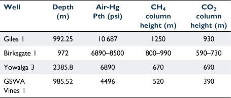
Within the Officer Basin, most of the formations contain lithologies that would make effective seals at all scales. All of the Neoproterozoic sedimentary rocks contain both carbonate and shale facies that are suitable as seals, and the best shale seals were deposited on flooding surfaces and form the bases of the Kanpa, Hussar, and Steptoe formations (Apak and Moors 2001; Raven and Dewhurst 2005). In this study, the laboratory measured gas (nitrogen) porosity ranges from 0.8 to 6.27% with an average of 2.9% in the Cambrian shales, whereas the porosity ranges from 0.15 to 2.85% with an average of 0.61% in the Neoproterozoic shales. Four shale samples with very low measured gas (nitrogen) porosities between 0.2 and 0.8% were selected for analysis via MICP testing. These samples are from the wells Giles 1 (992.25 mRT, MS3-S2), Birksgate 1 (972 mRT, MS4-S2), Yowalga 3 (2385.8 mRT, MS1-S5) and GSWA Vines 1 (985.52 mRT, MS2-S3). Table 6 presents the densities of fresh water (H2O), methane (CH4) and carbon dioxide (CO2) under in situ pressures and temperatures (P–T). Table 7 presents the calculated gas (pure CH4 and CO2) column heights under in situ P–T conditions calculated from MICP analysis. The derivation of gas column height from capillary threshold pressure is given in Ahmed (2002).

|
|
Besides the shales, salt penetrates from the lower part of the Browne Formation through to the overlying section. Salt provides an effective barrier to petroleum migrating from structural deeps (Apak and Moors 2001; Apak and Carlsen 2003) and, as well as forming good seals in petroleum systems, interbedded and dome salts (halite) have the potential for the future underground storage of hydrogen (Crotogino et al. 2018).
Conclusions
Petrophysical properties of the Neoproterozoic–Cambrian succession in the six selected wells from the Officer Basin have been derived through laboratory testing and well log interpretation. This was achieved through conventional and neural network interpretations and produced the continuous log values for porosity, permeability and Vshale. Integration of well logs, log interpretations, lithological descriptions and laboratory testing results, has determined the potential for conventional, tight and shale hydrocarbon reservoirs within the Neoproterozoic–Cambrian successions (MS1–MS4) in the Officer Basin as follows:
MS1–MS3, which correspond to the Centralian supersequences 1, 2 and 3, have mainly tight reservoirs with the average porosity ranging from 4.77 to 6.39% and geometric mean permeability ranging from 0.00087 to 0.01307 mD in the different sequences.
In MS4, the range in average porosity and geometric mean permeability of conventional reservoirs is 14.54–26.38% and 0.341–103.68 mD, respectively, in the different sequences. The range in the average porosity and geometric mean permeability of tight reservoirs are 5.58–8.6% and 0.00088–0.01102 mD, respectively, in the different sequences.
The ANN is capable of handling the complexity of petrophysical data, and the R2 between the neural network interpreted permeability and laboratory measurements is 0.7167.
Interpretation of very low permeability shales via MICP analysis demonstrates high sealing capacities, with derived potential gas column heights of 520–1250 m for pure CH4 and 390–930 m for CO2. Known salt units are likely to act as high-quality seals. This study demonstrates the presence of key petroleum system elements (reservoir and seal) in the Officer Basin of South Australia and Western Australia and highlights the value of advanced neural network methods for filling significant data gaps.
Data availability
The laboratory testing data supporting this study are available at Geoscience Australia’s eCat system (https://ecat.ga.gov.au/geonetwork/srv/eng/catalog.search#/metadata/145834). The well logging data and well completion reports are available at the South Australian Resource Information Gateway (SARIG) (https://minerals.sarig.sa.gov.au/QuickSearch.aspx), Petroleum exploration and production system (PEPS) – South Australia (https://peps.sa.gov.au/home), and the Western Australia Petroleum and Information Management System (WAPIMS) (https://wapims.dmp.wa.gov.au/WAPIMS/Search/Wells).
Conflicts of interest
All authors confirm there are no conflicts of interest.
Declaration of funding
This study was funded by Geoscience Australia’s Exploring for the Future program. No funding from external organisations was received for this research.
Acknowledgements
We thank Tehani Palu and Duy Nguyen for internal peer reviews at Geoscience Australia, and we thank David Nguyen, Leigh Kiewiet, Ludwig Monmusson, and Shane Kager at CSIRO for their analytical work. This paper is published with the permission of the CEO, Geoscience Australia.
References
Ahmed TH (2002) ‘Reservoir Engineering Handbook’, 2nd edn. p. 184. (Gulf Professional Publishing: Houston, TX)Apak, SN, and Carlsen, GM (2003). Seismic stratigraphic framework of the Neoproterozoic successions, Officer Basin, Western Australia. Geological Survey of Western Australia, Annual Review 2001–02, 80–87.
Apak SN, Moors HT (2001) Basin development and petroleum exploration potential of the Lennis area, Officer Basin, Western Australia. Western Australia Geological Survey, Report 77, p. 42.
Apak SN, Moors HT, Stevens MK (2001) GSWA Vines 1 well completion report, Waigen area, Officer Basin, Western Australia. GSWA Record 2001/18, p. 37.
Asquith G, Krygowski D (2004) Basic well log analysis. AAPG Methods in Exploration Series, No. 16, p. 244.
Avila J, Hauck T (2017) ‘Scikit-learn Cookbook’, 2nd edn. (Copyright ©2017 Packt Publishing Ltd) Available at https://www.packtpub.com/product/scikit-learn-cookbook-second-edition/9781787286382 [verified 20 January 2022]
Bailey A, Wang L, Dewhurst DN, Esteban L, Kager S, Monmusson L, Jarrett AJM, Henson P (2021) Exploring for the Future – petrophysical and geomechanical testing program data release, Officer Basin, Australia. Record 2021/28. Geoscience Australia, Canberra.
| Crossref |
Balashov D, Egorov D, Belozerov B, Slivkin S (2019) Prediction of wells productive characteristics with the use of unsupervised machine learning algorithms. Paper presented at the SPE Russian Petroleum Technology Conference, Moscow, Russia, 22–24 October 2019. Paper no. SPE 196857.
| Crossref |
Boult PJ, Rankin L (2004) Eastern Officer Basin – new play sleeping giant. In ‘Eastern Australasian Basins Symposium II’. (Eds PJ Boult, DR Johns, SC Lang) pp. 231–242. (Petroleum Exploration Society of Australia: Australia)
Bradshaw BE, Khider K, MacFarlane S, Carr L, Henson P (2021) Tectonostratigraphic evolution of the Centralian Superbasin (Australia) revealed through three-dimensional well correlations. Record 2021/01. Geoscience Australia, Canberra.
| Crossref |
Brocher, T (2005). Relations between elastic wavespeeds and density in the Earth’s crust. Bulletin of the Seismological Society of America 95, 2081–2092.
| Relations between elastic wavespeeds and density in the Earth’s crust.Crossref | GoogleScholarGoogle Scholar |
Brownlee J (2019) 8 Tricks for Configuring Backpropagation to Train Better Neural Networks. Available at https://machinelearningmastery.com/best-advice-for-configuring-backpropagation-for-deep-learning-neural-networks/ [verified 20 January 2022]
Carlsen, GM, Simeonova, AP, and Apak, SN (2003). Petroleum systems and exploration potential in the Officer Basin, Western Australia. The APPEA Journal 43, 473–494.
| Petroleum systems and exploration potential in the Officer Basin, Western Australia.Crossref | GoogleScholarGoogle Scholar |
Celma R, Farooq U, Douik H, Alawadhi A, Saputelli L (2020) Novel approach to link petrophysical groups into electrofacies by using NMR logs. Paper presented at the Abu Dhabi International Petroleum Exhibition & Conference, Abu Dhabi, UAE, November 2020. Paper no. SPE-203045-MS.
| Crossref |
Crotogino, F, Schneider, G-S, and Evans, DJ (2018). Renewable energy storage in geological formations. Journal of Power and Energy 232, 100–114.
| Renewable energy storage in geological formations.Crossref | GoogleScholarGoogle Scholar |
Cucuzza J (1987) Munta 1 well completion report. South Australia. Department of Primary Industries and Resources. Open file Envelope 1987, p. 368. Available at https://minerals.sarig.sa.gov.au/Details.aspx?DRILLHOLE_NO=712 [verified 20 January 2022]
Dunster JN (1986) Giles 1 well completion report. South Australia. Department of Primary Industries and Resources. Open file Envelope 1986, p. 199. Available at https://minerals.sarig.sa.gov.au/Details.aspx?DRILLHOLE_NO=1067 [verified 20 January 2022]
Ellis DV, Singer M (2007) ‘Well logging for Earth Scientists.’ (Springer Science and Business Media B.V.)
Gardner, GHF, Gardner, LW, and Gregory, AR (1974). Formation velocity and density – the diagnostic basics for stratigraphic traps. Geophysics 39, 770–780.
Geognostics (2021) ‘OZ SEEBASE® 2021 (March 2021).’ (Geognostics Australia Pty Ltd) Available at https://www.geognostics.com/oz-seebase-2021 [verified 20 January 2022]
Gravestock DI (1997) Chapter 5 Geological setting and structural history. In ‘Petroleum Geology of South Australia. Volume 3: Officer Basin’. Report Book, 97/19. (Eds JGG Morton, JF Drexel) pp. 7–22. (Department of Mines and Energy Resources: South Australia)
Grey K, Hocking RM, Stevens MK, Bagas L, Carlsen GM, Irimies F, Pirajno F, Haines PW, Apak SN (2005). Lithostratigraphic nomenclature of the Officer Basin and correlative parts of the Paterson Orogen, Western Australia. Geological Survey of Western Australia, Report, 93, p. 89.
Haines, WP, Hocking, RM, Grey, K, and Stevens, MK (2008). Vines 1 revisited: are older Neoproterozoic glacial deposits preserved in Western Australia? Australian Journal of Earth Sciences 55, 397–406.
Hashimoto T, Bailey A, Chirinos A (2018) ‘Onshore basin inventory volume 2: the Canning, Perth and Officer basins. Record 2018/18.’ (Geoscience Australia: Canberra). Available at https://ecat.ga.gov.au/geonetwork/srv/eng/catalog.search#/metadata/121557 [verified 20 January 2022]
Hect-Nielsen R (1990) ‘Neurocomputing.’ (Addison-Wesley: Menlo Park, CA, USA)
Henderson SW, Tauer RW (1967) Birksgate 1 well completion report. South Australia. Department of Primary Industries and Resources. Open file Envelope 1967, p. 121. Available at https://minerals.sarig.sa.gov.au/Details.aspx?DRILLHOLE_NO=273 [verified 20 January 2022]
Hopfield, JJ (1985). ‘Neural’ computation of decisions in optimization problem. Biological Cybernetics 52, 141–152.
| ‘Neural’ computation of decisions in optimization problem.Crossref | GoogleScholarGoogle Scholar | 4027280PubMed |
Huang, Y, Gedeon, TD, and Wong, PM (2001). An integrated neural-fuzzy genetic-algorithm using hyper-surface membership functions to predict permeability in petroleum reservoirs. Engineering Applications of Artificial Intelligence 14, 15–21.
| An integrated neural-fuzzy genetic-algorithm using hyper-surface membership functions to predict permeability in petroleum reservoirs.Crossref | GoogleScholarGoogle Scholar |
Julian D (2016) ‘Designing machine learning systems with Python.’ (Packt Publishing Ltd). Available at https://www.packtpub.com/product/designing-machine-learning-systems-with-python/9781785882951 [verified 20 January 2022]
Kalogirou, SA (2000). Applications of artificial neural-networks for energy systems. Applied Energy 67, 17–35.
| Applications of artificial neural-networks for energy systems.Crossref | GoogleScholarGoogle Scholar |
Karajas J, Yaylor D (1983) Hussar No 1 Completion Report. p. 8. Available at https://wapims.dmp.wa.gov.au/WAPIMS/Search/Wells [verified 20 January 2022]
Khider K, MacFarlane S, Bradshaw BE, Carr L, Henson P (2021) The Centralian Superbasin (Canning, Amadeus, Georgina and Officer basins) stratigraphic review and well correlations. Record 2021/10. Geoscience Australia, Canberra.
| Crossref |
Kingma DP, Ba JL (2015) Adam: a method for stochastic optimization. International Conference on Learning Representations (ICLR), 2015. Available at https://arxiv.org/pdf/1412.6980.pdf [verified 20 January 2022]
Morton JGG, Drexel JF (1997) Petroleum Geology of South Australia, Volume 3: Officer Basin. Department of Mines and Energy Resources, South Australia, Report Book, 97/19, p. 173.
Munday S, Edwards DS, Chandra J, Forbes A, Riley D, Wang L, Anderson J, Grosjean E, Bailey A, Boreham CJ (2021) Defining a chemostratigraphic framework for the Officer Basin. Record 2022/07. Geoscience Australia, Canberra.
| Crossref |
Ouadfeul, SA, and Aliouane, L (2015). Total organic carbon prediction in shale gas reservoirs from well logs data using the multilayer perceptron neural network with Levenberg Marquardt training algorithm: application to Barnett Shale. Arabian Journal for Science and Engineering 40, 3345–3349.
| Total organic carbon prediction in shale gas reservoirs from well logs data using the multilayer perceptron neural network with Levenberg Marquardt training algorithm: application to Barnett Shale.Crossref | GoogleScholarGoogle Scholar |
PEPS (2021) Petroleum exploration and production system (PEPS) – South Australia. Available at https://peps.sa.gov.au/home [verified 20 January 2022]
Raven MD, Dewhurst DN (2005) Mineralogical and Chemical Composition of Mudrocks from the Lancer-1 Stratigraphic Drillhole, Officer and Gunbarrel Basins, Western Australia. CSIRO Restricted Report No. 04-043, September 2004. Available at https://wapims.dmp.wa.gov.au/WAPIMS/Search/Wells [verified 20 January 2022]
Samson A (2018) Reservoirs and seals. In ‘The Petroleum Geology of South Australia. Vol 3: Officer Basin’. (Ed JGG Morton, JF Drexel) pp. 7–22. Report Book, 97/19. (Department of Mines and Energy Resources: South Australia)
Saputelli L, Celma R, Boyd D, Shebl H, Gomes J, Bahrini F, Escorcia A, Pandey Y (2019) Driving permeability and reservoir rock typing supported with self-organized maps SOM and artificial neural networks ANN - Optimal workflow for enabling core-log integration. Paper presented at the SPE Reservoir Characterisation and Simulation Conference and Exhibition, Abu Dhabi, UAE, 17–19 September 2019. Paper no. SPE 196704.
| Crossref |
SARIG (2021) South Australian Resource Information Gateway. Available at https://minerals.sarig.sa.gov.au/QuickSearch.aspx [verified 20 January 2022]
Schlumberger (1991) ‘Schlumberger Log Interpretation Principles/Applications.’ Seventh printing, ©Schlumberger 1991. (Schlumberger Wireline and Testing: Texas, USA)
Schlumberger (2013) ‘Schlumberger Log Interpretation Charts’, 2013 edn. ©Schlumberger 1991. (Schlumberger Wireline and Testing: Texas, USA)
Selvam RK (2018) Algorithms selected for neural network modelling. Optimization Algorithms – a brief overview. Available at https://www.sravikiran.com/GSOC18//2018/05/16/optimizers/ [verified 20 January 2022]
Shell Development (Australia) Pty Ltd (1981) Yowalga 3 well completion report (Officer Basin), 1981, p. 67. Available at https://wapims.dmp.wa.gov.au/WAPIMS/Search/Wells [verified 20 January 2022]
Stewart M (2019) Neural network optimization – covering optimizers, momentum, adaptive learning rates, normalization, and more. Available at https://towardsdatascience.com/neural-network-optimization-7ca72d4db3e0 [verified 20 January 2022]
Tingate PR, McKirdy DM (2003) Exploration opportunities in the Officer Basin, South Australia. South Australia. Department of Primary Industries and Resources. Report Book 2003/1.
Walter MR, Gorter JD (1994) The Neoproterozoic Centralian Superbasin in Western Australia: The Savory and Officer basins. In ‘The Sedimentary Basins of Western Australia’. Proceedings of the Petroleum Exploration Society of Australia Symposium, Perth. (Eds PG Purcell, RR Purcell) pp. 851–864.
Wang, L, Wong, PM, Kanevski, M, and Gedeon, TD (1999). Combining neural networks with kriging for stochastic reservoir modelling. In situ 23, 151–169.
Wang, L, Edwards, DS, Bailey, A, Carr, LK, Boreham, CJ, Grosjean, E, Normore, L, Anderson, J, Jarrett, AJM, McFarlane, S, Southby, C, Carson, C, Khider, K, and Henson, P (2021). Petrophysical and geochemical interpretations of well logs from the pre-Carboniferous succession in Waukarlycarly 1, Canning Basin, Western Australia. The APPEA Journal 61, 253–270.
| Petrophysical and geochemical interpretations of well logs from the pre-Carboniferous succession in Waukarlycarly 1, Canning Basin, Western Australia.Crossref | GoogleScholarGoogle Scholar |
WAPIMS (2021) Government of Western Australia, Department of Mines, Industry Regulation and Safety. Wells database. https://wapims.dmp.wa.gov.au/WAPIMS/Search/Wells [verified 20 January 2022]
Wong, PM, Jian, FX, and Taggart, IJ (1995). A critical comparison of neural networks and discriminant analysis in lithofacies, porosity and permeability predictions. Journal of Petroleum Geology 18, 191–206.
| A critical comparison of neural networks and discriminant analysis in lithofacies, porosity and permeability predictions.Crossref | GoogleScholarGoogle Scholar |
Yan, W, Wang, J, Liu, S, Wang, K, and Zhou, Y (2014). Logging identification for the Longmaxi mud shale reservoir in the Jiaoshiba area, Sichuan Basin. Natural Gas Industry 34, 30–36.
| Logging identification for the Longmaxi mud shale reservoir in the Jiaoshiba area, Sichuan Basin.Crossref | GoogleScholarGoogle Scholar |
Yu Y (2013) An experimental method to measure the porosity from cuttings: evaluation and error analysis. MS thesis, Texas Tech University, 2013, p. 74.
Zang WL (1995) Neoproterozoic depositional sequences and tectonics, eastern Officer Basin, South Australia. Department of Mines and Energy, South Australia, Report Book 95/21, p. 53.

Liuqi Wang is a Petrophysics Specialist at Geoscience Australia, working in the Minerals, Energy and Groundwater Division. He received his PhD in Petroleum Engineering and worked as a Research Fellow at the University of New South Wales before joining Geoscience Australia. His research interests include petrophysics, static and dynamic reservoir modelling, applied statistics and artificial intelligence. He is a member of PESA and European Association of Geoscientists and Engineers. |

Adam H. E. Bailey is a Petroleum Geoscientist at Geoscience Australia, with expertise in petroleum geomechanics, structural geology and basin analysis. He graduated with a BSc (Hons) in 2012 and a PhD in 2016 from the Australian School of Petroleum at the University of Adelaide. Working with the Onshore Energy Systems team at Geoscience Australia, Adam is currently working on the flagship Exploring for the Future (EFTF) program in Northern Australia, and he is the Geology Discipline Lead for the Geological and Bioregional Assessment Program. |

Lidena K. Carr is a Geoscientist for the Onshore Energy Systems project within the Resources Division at Geoscience Australia. She graduated from the Australian National University (ANU), majoring in Geology and Human Ecology, with a BA/BSc (Hons) in 2004, and she began working as a technical officer at the Research School of Earth Sciences (ANU). In 2007, she joined Geoscience Australia with the then ACRES (satellite imagery), and in 2009 she moved to the then Onshore Energy and Mineral Division to work as a Seismic iInterpreter and Basin Analyst. Currently, she is the acting Director of the Onshore Energy Systems directorate working on the EFTF program. She is a member of PESA and the Geological Society of Australia (GSA). |

Dianne S. Edwards is a Principal Petroleum Geochemist at Geoscience Australia, working in the Minerals, Energy and Groundwater Division. Her scientific focus is on defining the petroleum systems of Australia’s petroliferous basins, including both conventional and unconventional play types. She is involved in building database systems to release petroleum geochemical data via the portal https://portal.ga.gov.au. Dianne received her BSc (Hons) degree in Geology and her MSc degree in Organic Petrology and Organic Geochemistry from the University of Newcastle-upon-Tyne (UK). She was awarded her PhD from the University of Adelaide in 1996. In 2018, she received the Australian Organic Geochemistry Conference Medal for lifetime achievement in the field of Organic Geochemistry. Dianne is a member of PESA. |

Kamal Khider is a Senior Geoscientist in Geoscience Australia’s Resources Division, Energy Systems Branch. He has a BSc, MSc and PhD (Stratigraphy and Sedimentology) and a PhD in Applied Geochemistry. Kamal has long-standing academic and consultative experience in geosciences, working in many academic and industrial geological organisations in Australia, the Middle East and North Africa. He worked on the regional geological appraisal of the Eocene–Oligocene–Miocene boundaries International Geological Correlation Programme 174, regional geochemical assessment of the Cobar-Girilambone region in NSW and the Qld Carbon Dioxide Geological Storage Atlas. Since 2007, he has worked on several of Geoscience Australia’s petroleum and carbon capture and storage projects. Kamal is a member of the American Association of Petroleum Geologists, GSA and the Society for Sedimentary Geology. |

Jade Anderson works as a Geoscientist in basin systems at Geoscience Australia. She completed a PhD at the University of Adelaide in 2015, in the areas of metamorphic geology, geochronology and Proterozoic Australia tectonics. |

Christopher J. Boreham is a Principal Petroleum Geochemist at Geoscience Australia, working in the Minerals, Energy and Groundwater Division. He obtained his PhD in Chemistry at ANU and has worked at Geoscience Australia for over 4 decades. He is a Petroleum Geochemist with extensive experience in the application of organic geochemistry to the evolution of oil and gas in Australian sedimentary basins. More recently, he has extended these geochemical studies to unconventional petroleum (coal seam methane, shale gas and oil), natural molecular hydrogen and in CO2CRC’s studies on the injection of carbon dioxide (CO2) into a depleted natural gas field and a saline aquifer. |

Chris Southby is a Geoscientist in the Geoscience Australia Resources Division, Energy Systems Branch. He completed his Honours at ANU in 2004, on paleo-climate geochemistry of corals from Papua New Guinea. Since joining Geoscience Australia in 2008, he has contributed to a number of projects, including the National Carbon Mapping and Infrastructure Plan, the Vlaming Sub-basin CO2 Storage Assessment and the Houtman Sub-basin Prospectivity Project. He is now part of the Onshore Energy Systems team at Geoscience Australia, currently working under the EFTF project initiative. |

David N. Dewhurst is a Chief Research Scientist at CSIRO Energy in Perth. He holds a BSc (Hons) in Geology from the University of Sheffield (UK) and a PhD in Physics from the University of Newcastle Upon Tyne (UK). He previously held post-doctoral positions at the University of Birmingham (UK), the University of Newcastle upon Tyne (UK), the Institut Français du Pétrole near Paris and Imperial College, London, before moving to CSIRO in 1998. He works on mechanical and physical properties of rocks for petroleum exploration and development, specialising in overburden and gas shales, as well as reservoir and seal evaluation for geological storage of CO2 and other gases. |

Lionel Esteban holds a PhD in applied geophysics, magnetic environment and petrophysics from joint French Universities (University Paul Sabatier-Toulouse and University of Strasbourg, and Institut de Physique du Globe) and the French Nuclear Waste Management (Andra). Lionel Esteban is currently a Principal Petrophysicist at CSIRO (Perth, WA), a member of the Society of Petrophysicists and Well Log Analysts and the Society of Petroleum Engineers, and an academic editor of the Geofluids journal. He develops and tests petrophysical experimental laboratory approaches and integrates them into log analyses to characterise and understand the physical property responses of unconventional and conventional reservoirs at different scales, using a wide spectrum of petrophysical tools, including X-ray imaging, electrical, nuclear magnetic resonance, mechanical, and core flooding under (or not) high pressure/high temperature. His current research focuses on low permeability reservoirs to understand clay mineral relationships, hydrocarbon storage and sealing capacity, CO2–rock interactions and core flooding in carbonates, and drilling mud effects on rock properties in conventional reservoirs. |

Stuart Munday has worked for Chemostrat for 5 years, based initially in New Zealand and now in Perth, working on projects throughout the APAC region. Prior to this, he was a Senior Geologist at New Zealand Oil and Gas, but he has spent most of his career at BG Group, where he has worked on various North African assets prior to being posted to QGC in Brisbane. Stuart previously worked for Roc Oil in the North Sea and at Exploration Consultants Ltd, where his focus was on the basins of sub-Saharan Africa. He has a BSc in Geology, a MSc in Petroleum Geology and is a Fellow of the Geological Society of London. |

Paul A. Henson graduated from the University of Tasmania and is currently the Director of the Onshore Energy Systems Section at Geoscience Australia. He has extensive experience in the minerals sector, working on mineral systems in Proterozoic and Archaean terranes. Since 2010, he has led the Australian Governments’ Onshore Carbon Storage Project, undertaking deep onshore drilling and seismic acquisition programs in collaboration with the states and industry. In addition, he now manages the EFTF–energy program, leading a team of researchers to acquire new pre-competitive geoscientific data to improve our understanding of the oil and gas potential of Australian onshore basins. |