

Petroleum supersystems in the greater McArthur Basin, Northern Territory, Australia: prospectivity of the world’s oldest stacked systems with emphasis on the McArthur Supersystem
Amber J. M. Jarrett A * , Tim J. Munson A , Ben Williams A , Adam H. E. Bailey B and Tehani Palu BA Northern Territory Geological Survey, GPO Box 4550, Darwin, NT 0800, Australia.
B Geoscience Australia, GPO Box 378, Canberra, ACT 2601, Australia.
The APPEA Journal 62(1) 245-262 https://doi.org/10.1071/AJ21018
Submitted: 17 December 2021 Accepted: 3 February 2022 Published: 13 May 2022
© 2022 The Author(s) (or their employer(s)). Published by CSIRO Publishing on behalf of APPEA. This is an open access article distributed under the Creative Commons Attribution 4.0 International License (CC BY).
Abstract
This study assesses the prospectivity of the world’s oldest known stacked petroleum systems from the Proterozoic greater McArthur Basin (Northern Territory, Australia), which has immense potential to host both conventional natural gas and oil, in addition to shale-gas accumulations. The Mesoproterozoic succession of the Beetaloo Sub-basin and surrounding region hosts the Territory’s premier shale-gas play and is at an advanced stage of exploration for shale hydrocarbon plays. However, there is also potential for natural gas in older sedimentary packages, with flows and shows reported in underlying Paleoproterozoic successions. At the continent-scale, four regional petroleum supersystems are identified and described in order to provide a platform for consistent nomenclature at the sedimentary package and group level; in ascending stratigraphic order; these are the Paleoproterozoic Redbank and McArthur supersystems, the Paleoproterozoic–Mesoproterozoic Lawn Supersystem, and the Mesoproterozoic Beetaloo Supersystem. The Redbank and Lawn supersystems are newly named and defined, and the Beetaloo Supersystem is renamed from the former Urapungan Supersystem. Eight possible conventional natural gas plays and six shale-gas plays are documented within the McArthur Supersystem, which incorporates Glyde Package successions of the McArthur Basin and the Birrindudu Basin. Petroleum play concepts are also described from this supersystem to assist with assessing the potential for gas resources. A better understanding of the petroleum systems of the greater McArthur Basin is critical to the targeting of areas for geoscience data acquisition in order to facilitate the reduction of exploration search space; and it enables a more rigorous assessment of the potential for conventional and unconventional hydrocarbon resources at local (play) and regional scales.
Keywords: Barney Creek Formation, conventional, geochemistry, Glyde Package, greater McArthur Basin, isotopes, kinetics, natural gas, petroleum plays, petroleum supersystems, pyrolysis, shale gas, unconventional.
Introduction
Natural gas has the potential to be a key resource in Australia’s transition towards a low-carbon economy and is bridging the gap between coal and renewable energy (Gürsan and de Gooyert 2021; Mohammad et al. 2021). The Northern Territory (NT) Government’s gas strategy is to be a world-class gas producer, manufacturer and services hub by 2030 (NT Government 2019). Darwin already has a significant liquefied natural gas export hub, and there is significant potential for expansion, utilising gas from both offshore and onshore gas developments (NT Government 2019).
The Beetaloo Sub-basin of the greater McArthur Basin is a 28 000 km2 subsurface depocentre that contains Mesoproterozoic-aged shales of the Roper Group, which host the Territory’s premier shale hydrocarbon plays (e.g. Jackson et al. 1986; Warren et al. 1998; Côté et al. 2018; Williams 2019; Hall et al. 2020). The sub-basin has been listed by the Australian Government as a key element of the Australian Government’s gas-fired recovery strategy (Morrison et al. 2020; Department of Industry, Science, Energy and Resources 2021). Significant resources are being allocated by both the federal and NT governments on this strategic area to accelerate development (NT Government 2019; Department of Industry, Science, Energy and Resources 2021). The region is at an advanced stage of exploration, with industry activity rapidly accelerating in 2021 (Riddle 2021; Underwood 2021; White 2021; Scrimgeour 2022). A volumetric resource assessment of the Mesoproterozoic shales, undertaken by the Northern Territory Geological Survey (NTGS), reported mean (P50) original hydrocarbons in place values of 772 MMbbl oil in the Kyalla Formation, and 83 MMbbl oil and 202 TCF gas in the Amungee Member of the Velkerri Formation (Revie 2017). This estimate has increased in recent years to ~500 TCF gas in the B-shale of the Amungee in permits EP98, EP117 and EP76 (Table 1; Falcon Oil and Gas 2021). The total in place resource for the entire basin is likely multiples of that figure. Reported gas discoveries, including both liquid-rich and dry gas, confirm the presence of technically recoverable hydrocarbons (Fig. 1, Table 1). There is also good hydrocarbon potential in the older sedimentary packages of the greater McArthur Basin, with flows and shows reported in Paleoproterozoic successions demonstrating the prospectivity of these successions (Fig. 1).
|

|

|
A primary challenge for prospectivity assessment and exploration in the greater McArthur Basin is the limited availability of data in many areas. For example, while the southern McArthur Basin has been heavily drilled, the correlative northern McArthur Basin is a frontier region without any drill penetrations (https://strike.nt.gov.au/; Fig. 2). One way to make predictions about the resource potential in these underexplored areas of the NT, and more broadly across Australia, is to provide a consistent nomenclature and continent-scale petroleum systems framework across the region (Fig. 2).
As a component of the Resourcing the Territory Initiative, NTGS is conducting holistic, regional-scale petroleum studies across the greater McArthur Basin. Collaborations between NTGS, CSIRO, government, industry and academia have led to an enhanced understanding of the regional geology, architecture and resource potential of the basin (e.g. Munson 2016; Revie 2017; Collins et al. 2018; Jarrett et al. 2019; Cox et al. 2022). Herein, we highlight some of the results of this ongoing program with a primary focus on a new petroleum supersystems framework to better document and correlate the distribution of petroleum systems across the components of the greater McArthur Basin, before focusing on individual play types within the McArthur supersystem as a way to highlight the utility of this nomenclature at regional through to play scales.
The McArthur Supersystem has been intermittently explored for several decades for conventional and unconventional gas and oil resources, primarily in the McArthur Group within the Batten Fault Zone of the southern McArthur Basin (Figs 1, 2). Hydrocarbon discoveries in the Batten Fault Zone have greatly increased the prospectivity of the supersystem (Johnson et al. 2013; Munson 2014; Croon et al. 2015). Several organic-rich carbonaceous and pyritic shales are known from the McArthur Supersystem, most notably within the Barney Creek Formation of the Glyde package (Fig. 3). This unit is of particular significance, as it is assumed to be the source rock for the Barney–Coxco conventional gas play (e.g. Johnson et al. 2013) and is also a potential unconventional shale-gas play (e.g. Baruch et al. 2015; Croon et al. 2015), as well as being the host of the McArthur River (HYC) zinc–lead–silver (Zn–Pb–Ag) mine (Ahmad et al. 2013). However, other Paleoproterozoic shales across the greater McArthur Basin also have good to excellent organic richness (Fig. 4), and these understudied units warrant further investigation within a revised petroleum supersystems framework.

|

|
Geology of the greater McArthur Basin
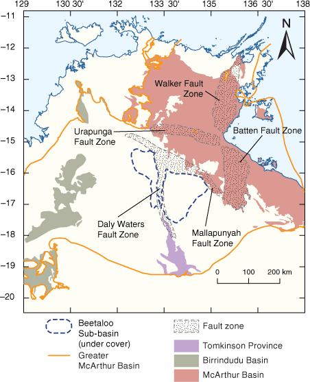
The informally named greater McArthur Basin (Close 2014) is a vast Paleoproterozoic–Mesoproterozoic-aged terrane that extends over 180 000 km2 from Western Australia, through the NT and into northwestern Queensland (Figs 1, 2). The basin unconformably overlies Archaean and Paleoproterozoic rocks of the Northern Australian Craton and is unconformably overlain by Neoproterozoic–Paleozoic cover successions (Ahmad et al. 2013). The greater McArthur Basin successions are unmetamorphosed and are mostly flat-lying or gently folded. However, deposition and subsequent structural deformation within the basin was strongly influenced by a number of major faults and fault zones at various scales and orientations. Of particular significance in the central and eastern parts of the basin are the north-trending Batten, Walker and Daly Waters fault zones; the east-trending Urapunga Fault Zone; and the northwest-trending Mallapunyah Fault Zone (Fig. 1; Williams 2019). These complex fault zones typically had long histories of reactivation and influence on basin architectures and incorporate major faults that include strike-slip, oblique, normal, reverse and thrust geometries. Fault structures in the northern and western parts of the basin are generally poorly studied, and their influence on the development of the basin is less clear (Williams 2019; Blaikie and Kunzmann 2020).
The greater McArthur Basin, as currently defined, incorporates sedimentary successions of the McArthur Basin sensu stricto, Birrindudu Basin and the Tomkinson Province, which are interpreted to have subsurface continuity, based on seismic interpretation (Hoffman 2014), drilling and geochronology (Munson et al. 2020 and references therein). The succession has been divided into five unconformity-bounded basin depositional phases informally termed ‘packages’ (Rawlings 1999) that were extended across the greater McArthur Basin by Close (2014). In ascending order, these are the Paleoproterozoic Redbank, Goyder, and Glyde packages; and the Mesoproterozoic Favenc and Wilton packages (Fig. 3). Each package is characterised by its distinctive lithofacies, style and composition of volcanism, and basin-fill architecture (Rawlings 1999). NTGS has an ongoing program to establish a robust sedimentary and stratigraphic framework across the greater McArthur Basin in order to support more detailed studies, including understanding the resource potential (e.g. Munson 2016, 2019, in press; Munson et al. 2020; Jarrett et al. 2021).
Continent-scale petroleum supersystems across the greater McArthur Basin
The petroleum supersystem approach, coined by Bradshaw (1993), is a methodology to understand hydrocarbon occurrences throughout Australia at a continent-scale. The petroleum supersystem links sedimentary packages of similar age, structural history, depositional environment and hydrocarbon potential, both within and between basins. Source rocks, such as shale or coal, are the primary element of both natural gas and shale-gas systems (Jarvie 2012); petroleum supersystems can therefore be subdivided and classified by source rock age, which suits both system classifications.
The petroleum supersystems approach can be a powerful predictive tool for understanding the petroleum systems elements in frontier basins with limited datasets (Bradshaw et al. 1994). In the greater McArthur Basin there is also potential to use this approach when describing the petroleum potential of contemporaneous formations that might be included in as many as five different groups across the region. Additionally, the supersystems approach can be used to directly predict the petroleum potential in successions with limited data, for example, in the northern McArthur Basin where there are no well penetrations (Ahmad et al. 2013).
Seven petroleum supersystems have previously been recognised across Australia (Bradshaw et al. 1994). Two of these were defined in the greater McArthur Basin: (1) the Paleoproterozoic McArthur Supersystem and (2) the Mesoproterozoic Urapungan Supersystem. Jarrett et al. (2021) identified the need to expand the Australia-wide petroleum supersystems to include two additional petroleum supersystems in the greater McArthur Basin; these are classified using the sedimentary package framework of Rawlings (1999) and are described below (Figs 2, 3).
Redbank Supersystem
The Paleoproterozoic Redbank Petroleum Supersystem (new name) is the oldest of the currently known petroleum supersystems in Australia. It is hosted in the Redbank Package of the greater McArthur Basin and is named after the Redbank Copper Field in the southeastern McArthur Basin, where oil stains and solid bitumen have been identified during exploration for sediment-hosted copper (Knutson et al. 1979; Munson 2014). In the McArthur Basin, the Redbank Package contains two organic-rich shale units: the McDermott and Wollogorang formations of the Tawallah Group; these constitute two Redbank petroleum systems as shown in Fig. 4. The current understanding of this supersystem is limited, as it is based on only 12 drill intersections (Jarrett and Munson 2022a). Correlative units within the greater McArthur Basin include the Katherine River Group in the northern McArthur Basin, the Tolmer and Birrindudu groups in the Birrindudu Basin, and possibly the Tomkinson Creek and Hatches Creek groups in the Tomkinson Province (Fig. 5).

|
McArthur Supersystem
The Paleoproterozoic McArthur Petroleum Supersystem is named after the McArthur Group of the Glyde Package. This group contains Australia’s geologically oldest oil and gas discoveries in addition to wells containing both oil bleeds and gas shows (Jackson et al. 1988; Croon et al. 2015). The McArthur Supersystem was first defined by Bradshaw et al. (1994) and envisioned to include correlative units in the Birrindudu Basin and Lawn Hill Platform. In the McArthur Basin, the McArthur Group contains three organic-rich shale units: (1) the Barney Creek Formation, (2) Caranbirini Member of the Lynott Formation and (3) the Yalco Formation. Within the McArthur Basin, correlative units include the Saint Vidgeon Formation of the Vizard Group and the Vaughton Siltstone of the Balma Group (Fig. 2). Within the greater McArthur Basin, correlative units include the Fraynes Formation, Kunja Siltstone, and Mallabah and Pear Tree dolostones of the Limbunya Group of the Birrindudu Basin (Figs 3, 4). This supersystem and its included petroleum systems are discussed in more detail below.
Lawn Supersystem
The Paleoproterozoic–Mesoproterozoic-aged Lawn Supersystem (new name) is named after the Lawn Hill Formation of the McNamara Group in the Lawn Hill Platform; organic-rich shales of the Lawn Hill Formation host shale gas (Gorton and Troup 2018; Bailey et al. 2019; Jarrett et al. 2020). Regional sequence stratigraphic studies across the McArthur Basin, Mount Isa Province and Lawn Hill Platform have correlated the Lawn Hill Formation with the Doomadgee Formation (Fickling Group) of the Lawn Hill Platform in the NT and with the Favenc Package of the McArthur Basin (Southgate et al. 2000). The Egilabria 2 horizontal well in northwest Queensland flared gas at low surface pressures following an eight-stage fracture treatment in 2014 (Longdon 2014). Oil stains and solid bitumen have also been reported in Lawn Hill Formation drill core (Jarrett et al. 2020) and from the Lawn Hill Formation at the Century lead–zinc mine (Broadbent 1999). Hydrocarbon shows have not been reported from equivalent strata in the McArthur Basin; however, in the Birrindudu Basin, oil stains and hydrocarbon indications have been noted in correlative formations, including the Seale Sandstone of the Wattie Group and the Timber Creek and Skull Creek formations of the Bullita Group (Fig. 3). Organic-rich rocks have not yet been identified in Lawn Supersystem equivalent rocks within the greater McArthur Basin (Revie et al. 2022).
Beetaloo Supersystem
The Mesoproterozoic Beetaloo Supersystem (revised name) is the youngest of the petroleum supersystems in the greater McArthur Basin. The supersystem was formerly named the Urapungan supersystem by Bradshaw (1993) after live oil was discovered in drill core from BMR Urapunga 4 (Jackson et al. 1986). However, this term is somewhat confusing to current explorers, as the Urapunga region of the McArthur Basin has little shale-gas potential due to lower thermal maturity (Jarrett et al. 2019; Revie et al. 2022), shallow current day depth, extensive faulting and thinner sedimentary successions (Munson 2014, 2016). This supersystem is therefore here renamed the ‘Beetaloo Supersystem’ after the Beetaloo Sub-basin, where current exploration is focused and extensive petroleum resources have been identified. Organic-rich shales of this supersystem are thickest and most prospective within and adjacent to this sub-basin (e.g. Revie 2017; Cox et al. 2022). Conventional oil and gas, as well as shale hydrocarbon discoveries, shows and fracture-stimulated flows are known from this supersystem (Côté et al. 2018; Altmann et al. 2020; Riddle 2021; Underwood 2021; Scrimgeour 2022). The Beetaloo Supersystem is part of the unconformity-bounded Wilton Package (Rawlings 1999; Munson 2016). This sedimentary package contains three mudrock units with elevated organic carbon content; in ascending stratigraphic order, these are the Mainoru Formation of the Collara Subgroup, and the Velkerri and Kyalla formations of the overlying Maiwok Subgroup. Proposed regional correlations with basins to the west and east increase the prospectivity fairway for this supersystem. The Beetaloo Supersystem is subdivided into four petroleum systems as illustrated in Fig. 4 and presented in Jarrett and Munson (2022b).
Basin-scale petroleum systems of the McArthur Supersystem
The two most prospective petroleum supersystems of the greater McArthur Basin are the McArthur and Beetaloo supersystems (Munson 2014). Petroleum discoveries, and widespread petroleum indications and shows have been reported from both supersystems, and both are the subject of ongoing exploration programs. The Beetaloo Supersystem and its included petroleum systems are relatively well documented (see above), whereas the McArthur Supersystem and its petroleum systems are less well studied and have never previously been fully described. This section aims to better define the supersystem and its component petroleum systems.
Five broad petroleum systems, based on the potential source rocks, have been identified within the McArthur Supersystem (Figs 4, 5). These include three systems previously defined by Laurie (2012) and two additional systems newly defined herein. The petroleum systems are sequentially numbered 1–5 from the oldest organic-rich shale to the youngest, in line with the method of Bradshaw et al. (1994). Within each of these petroleum systems, a number of potential play types are possible. Table 2 lists the potential source rocks, conventional and shale-gas reservoirs, and seals for each of the basin-scale petroleum systems. Although many of these play types are hypothetical, this high-level summary demonstrates the potential for many source–reservoir pairs within the basin, which might contain up to 14 natural gas and 9 shale-gas play types. This is in line with detailed petroleum play analysis in the Beetaloo Supersystem, where Côté et al (2018) described five different petroleum play types from two shale packages.

|
Source rocks and maturity
Collation of legacy data from all shale units of the greater McArthur Basin has been a defining priority of the NTGS Resourcing the Territory initiative. This has followed-on from a highly successful data-acquisition program under the previous NTGS Creating Opportunities for Resource Exploration initiative and the creation of Digital Information Package 014 (DIP-014): Shale Resource Data of the greater McArthur Basin (Revie 2014). The latest edition of DIP-014, published in February 2022 contains 22 904 data points from 80 stratigraphic units, including 2499 programmed pyrolysis data points in the McArthur Supersystem (Revie et al. 2022). These data have been used in this study to assess the petroleum potential of the McArthur Supersystem.
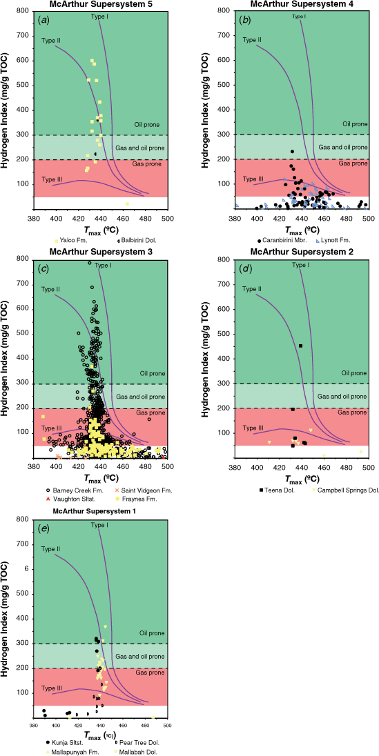
Within the McArthur Supersystem, there are 14 potential source rocks with very good (>2% total organic carbon; TOC) to excellent (>4% TOC) organic richness (Fig. 4). Of these, several formations are lateral equivalents spanning hundreds of square kilometres (Figs 2, 5). These include the following units: Pear Tree Dolostone, Mallabah Dolostone, Kunja Siltstone and Mallapunyah Formation (petroleum system 1); Campbell Springs Dolostone and Teena Dolostone (petroleum system 2); and Barney Creek Formation, Saint Vidgeon Formation, Fraynes Formation and Vaughton Siltstone (petroleum system 3). The quality of available TOC data from these formations is highly variable. For example, the Vaughton Siltstone has only been sampled from creek bank exposures; these samples have returned a maximum TOC of 2.45% (average 0.37%, s.d. 0.34, n = 24). These samples have been exposed to the elements, so it is likely that TOC and kerogen data acquired from fresh rock sampled subsurface would be significantly better. The coeval Barney Creek Formation reaches a TOC of 18% in drill core (average 1.4%, s.d. 1.3, n = 1779), and this could be a much more accurate reflection of the subsurface petroleum geochemistry.
The hydrogen index (HI) can determine the generated products at the time of peak maturity (e.g. Peters and Cassa 1994). Present day HI plotted in Fig. 6 demonstrates a range of expelled products and kerogen types across the McArthur Supersequence. The Kunja Siltstone, Campbell Springs Dolostone, Fraynes Formation, Barney Creek Formation and Reward Dolostone all appear to be oil prone (HI > 300 mg HC/g TOC; Fig. 6). The Mallabah Dolostone, Lynott Formation and the Yalco Formation are oil and gas prone (HI 200–300 mg HC/g TOC), and gas-prone kerogen (HI 50–200 mg HC/g TOC) occurs in the Pear Tree Dolostone, Mallapunyah Formation, Tooganinie Formation, Saint Vidgeon Formation, Caranbirini Member of the Lynott Formation and the Balbirini Dolostone (Fig. 6a). Many of the shales are also thermally mature in the zone of oil and gas generation and may be potential sweet spots for shale oil or shale gas (Jarvie 2012). A significant amount of data have maximum temperature (Tmax) values >435°C and production index (PI) values >0.2, and/or have HI values <50 (Revie et al. 2022) and are therefore thermally mature; these data are likely to provide only a limited insight into the true petroleum potential of the region. In overmature shales, there is also the potential for produced hydrocarbons to be retained in the shales, similar to shales of the coeval Lawn Hill Platform (Bailey et al. 2019). Rock-Eval pyrolysis of the McArthur Supersystem samples demonstrates a range of thermal maturities from immature to overmature across the region (Fig. 6). This largely correlates with bitumen reflectance data, albeit with significantly less data and variable quality (Jarrett et al. 2020; Revie et al. 2022).
|
Gas geochemistry
Hydrocarbon flows, shows and indications are known from at least 11 formations in the McArthur Supersystem (Figs 2, 5). Many of these hydrocarbon shows were either not sampled at the time of drilling, were not analysed for the complete compositional and isotopic dataset, or are not in the public domain. Publicly available gas composition data has been collated for six gas samples analysed from three wells; (1) GRNT 79-9, (2) Glyde 1 and (3) Kilgour North 1 (Table 3). As there are no isotopic data in the public domain, the utility of gas composition data is limited. The results demonstrate that McArthur Supersystem gasses are all wet with varying concentrations of associated hydrocarbon liquids. Both dry and wet gasses are known from the younger Beetaloo Supersystem, with distinct play types modelled and mapped (Côté et al. 2018; Hall et al. 2020). This is likely a reflection of the limited petroleum wells testing the McArthur Supersystem. Another significant finding is that the concentrations of CO2 are <0.2 mol% (Revie et al. 2022). This is very low compared with gas in the offshore NT, such as the Barossa-Caldita fields, which have reservoir CO2 concentrations of 16–30 mol%, and the Ichthys Field, which has reservoir CO2 concentrations of 8–18 mol% (Boreham et al. 2001, 2018). The carbon footprint of natural gas from the McArthur Supersystem is significantly lower than surrounding systems, making this supersystem an attractive exploration target in Australia’s transition to a lower-carbon economy.

|
Conventional reservoirs
Several shale and dolomitic units are potential petroleum reservoirs in the McArthur Supersystem as is shown by the flows and shows data in Table 2 and the petroleum summary in Fig. 5. The Teena Dolostone, and in particular the Coxco Dolostone Member in the southern McArthur, is a proven conventional reservoir in the Barney Creek-Teena/Coxco/Reward(!) system (Fig. 5, Table 2). Lateral well Armour Energy Glyde-1 ST1 tested the Coxco Dolostone Member and flowed gas to surface at a rate of 3.33 mmscfd (Johnson et al. 2013; Croon et al. 2015). This well is approximately 300 m west of the 1979 exploration drillhole Amoco GRNT-79-9, which also flowed gas to surface from the Coxco Dolostone (Thomas 1981). Permeability in the member is interpreted to result from structural brecciation and fracturing along the Emu and Tawallah faults and zones of solution brecciation (Jackson et al. 1988).
The Barney Creek Formation has potential as both a conventional reservoir and shale-gas reservoir due to the variability in lithology (e.g. Ahmad et al. 2013). Its ability to reservoir hydrocarbons is demonstrated by numerous hydrocarbon shows that include gas shows, flows and flares from the formation in drillholes GRNT-79-9, Cow Lagoon-1 and Glyde-1, in addition to significant oil and gas shows in Lamont Pass-3 (Fig. 2). Conventional reservoirs could be also present in the form of coarse breccia intervals that have locally high primary and secondary porosity (Jackson et al. 1988). In the southern McArthur Basin, these include the Cooley Dolostone Member and several types of breccias within the HYC Pyritic Shale Member as well as lateral equivalents across the region (Fig. 4). Additionally, formations in the overlying packages could act as reservoirs to any generated and migrated hydrocarbons from the McArthur Supersystem (Fig. 5).
Potential seals
Seals for conventional reservoirs within the basin and overlying successions are potentially provided by impervious overlying units, impervious intraformational rock layers, or faults (Munson 2014). Several fine-grained shales and mudstones, well-cemented coarser clastic rocks and diagenetically altered carbonate rocks are potential petroleum seals in the McArthur Supersystem (Fig. 5). In the southern McArthur Basin, the Emmerugga Dolostone, Barney Creek Formation, Lynott Formation (Caranbirini and Donnegan members), Yalco Formation and shaly sections in the lower Balbirini Dolostone might act as seal rocks. In the central McArthur Basin, intraformational mudstones in the Nagi Formation may act as seals. In the northern McArthur Basin, the Koolatong and Slippery Creek siltstones, Vaughton Siltstone and Yarrawoi Formation, Zamia Creek Siltstone and Ulunourwi Formation, and inter-formational mudstones in the Yarrawirri Formation might act as seals. Additionally, the overlying Favenc Package may act as a regional seal to any generated and migrated hydrocarbons from the McArthur Supersystem. Unfortunately there are no data available to test these hypothetical petroleum systems elements.
Unconventional shale-gas reservoirs
Several shale and dolomitic units have considerable potential for shale gas and liquids over large areas of the greater McArthur Basin (Munson 2014; Baruch et al. 2015). Eleven potential shale-gas and liquids targets (Table 2) have been identified in the McArthur Supersystem, and these are divided into five regional systems (Fig. 5, Table 2).
The Barney Creek Formation is currently considered to be the most prospective unconventional shale oil and gas play in the McArthur Group and is the most data-rich (Revie et al. 2022). This formation ranges in thickness from <200 m to as much as 1200 m in places and has a very extensive regional distribution within the Batten Fault Zone. It is also interpreted as being extensive in the subsurface elsewhere in the greater McArthur Basin, and regional correlations have been interpreted with the Fraynes Formation (Munson 2019), Saint Vidgeon Formation and Vaughton Siltstone (Munson 2019, in press). The Barney Creek Formation has significant TOC and oil- to gas-prone organic matter type (Fig. 6). Armour Energy (2012) reported that the formation is oil mature at the surface and predicted it to be wet-gas mature in the depth range 350–2400 m, and dry-gas mature where it is over 2400 m deep (Armour Energy 2012 in Munson 2014). However, results from Lamont Pass 3 indicate that the formation is in the oil window to a depth of 780 m, at least in the vicinity of that well (Croon et al. 2015). The high dolomite and silt components within Barney Creek Formation Shale provide favourable conditions for large volumes of oil and gas to be held in pore spaces, likely to be recovered with hydraulic fracturing (Munson 2014; Baruch et al. 2015).
Basin-scale play types in the McArthur Supersystem
There are a number of proven and possible play types within the McArthur Supersystem (Figs 7, 8, Table 2). Exploration to date has primarily focused on small structural sub-basins within the Batten Fault Zone (e.g. the Glyde Sub-basin), and detailed targets and exploration leads in this region are mapped in Fig. 7. In other regions where geophysical or drillhole data are poor, sparse or absent, the McArthur Supersystem play types remain hypothetical. In these frontier areas, it is assumed that the potential plays are analogous to those of the Batten Fault Zone.


|
Armour Energy, now operating as McArthur Oil and Gas, spent almost a decade exploring for and mapping leads and prospects within the McArthur Supersystem across the Batten Fault Zone (Fig. 7; Lingo 2021), using a combination of aerial photography, airborne gravity and aeromagnetic surveys. Identified prospects include both conventional and shale-gas targets from the same source kitchen (Fig. 8). Discoveries at the Cow Lagoon, Lamont Pass 3 and Glyde prospects include anticlinal closures (e.g. Cow Lagoon 1 and Kilgour 1), including four-way dip-closed anticlines and fault-closed traps (e.g. Glyde prospect; Johnson et al. 2013; Croon et al. 2015).
Faulting across the greater McArthur Basin was likely synchronous with deposition of Glyde Package sediments (Haines et al. 1999; Blaikie and Kunzmann 2020). This could result in structural and brecciated traps in carbonate rocks, with hydrocarbons sourced from organic-rich shales and carbonate rocks (Jackson et al. 1988), as has been noted in several formations in drill core from Cow Lagoon 1 (Johnson et al. 2013). The most significant conventional reservoir discovered to date, in the Coxco Dolostone Member, comprises structural breccias and fractures along the Emu and Tawallah faults, together with talus or scree breccias occurring adjacent to faults.
The Coxco Dolostone Member also has potential for a hydrothermal dolostone play whereby low-temperature hydrothermal events could have generated and migrated hydrocarbons, forming secondary vugular pores for accumulation and preservation (Munson 2014). The presence of galena and pyrite pseudomorphs throughout the McArthur Group of the southern McArthur Basin and in the Limbunya Group in the Birrindudu Basin (Dunster and Ahmad 2013) is potential evidence of pervasive hydrothermal fluid flow through the basin.
In the northern McArthur Basin, the Walker Fault Zone contains an equivalent stratigraphic succession to the McArthur Group (Balma Group, see Haines et al. 1999), and the structural setting appears to be similar to that in the Batten Fault Zone (Haines et al. 1999). However, due to an almost complete lack of drilling or seismic data in this region, the petroleum prospectivity of the northern McArthur Basin remains largely speculative. Nevertheless, some limited studies have been undertaken in this region that suggest it might be very prospective (Munson 2014; Warburton 2015; Frichot et al. 2017; Underwood 2021). In particular, the up-to 1000 m-thick Vaughton Siltstone is likely a chronostratigraphic equivalent to the Barney Creek Formation and contains a similar range of rock types. Within the Empire Energy tenement, this unit and other Barney Creek equivalents have a combined unrisked prospective gas resource of 11 TCF 2U (Underwood 2021).
Stratigraphic pinchout traps and sub-thrust or over-thrust plays might also be present, as these structures have been observed on seismic data (see Rawlings 2004). This includes potential reservoirs in coarse siliciclastic facies that have been shed from fault scarps (e.g. within the Stretton Sandstone in the southern McArthur; Munson 2014). Towards the west in the Birrindudu Basin, regional mapping (e.g. Beier et al. 2002) has identified favourable conditions for stratigraphic pinchout traps and gently folded anticlinal and fault-bounded structural traps. Broad correlations of play types across the greater McArthur Basin cannot be made with certainty without an understanding of the basin-scale petroleum systems and the continent-scale petroleum supersystems. The results of this study, for the first time, provide a consistent approach for continent- to play-scale petroleum exploration in the Proterozoic greater McArthur Basin.
Summary
This study describes the prospectivity of the world’s oldest stacked petroleum systems from the greater McArthur Basin. Broad correlations of play types across the greater McArthur Basin cannot be made with certainty without an understanding of the basin-scale petroleum systems and the continent-scale petroleum supersystems. At the continent-scale, four regional Paleoproterozoic–Mesoproterozoic petroleum supersystems (in ascending order, the Redbank, McArthur, Lawn and Beetaloo supersystems) are identified, defined and described in order to provide a platform for consistent nomenclature at the sedimentary package and group level. Two of these supersystems (McArthur and Beetaloo) have proven resources and have attracted significant exploration attention. The relatively well-studied, Mesoproterozoic Beetaloo Supersystem hosts large-scale shale-gas and liquid resources in shales of the Roper Group in the Beetaloo Sub-basin. The Paleoproterozoic McArthur Supersystem hosts conventional natural gas and possibly unconventional shale gas in carbonate rocks and shales of the McArthur Group in the Batten Fault Zone. The proven and possible petroleum systems of this supersystem have not previously been well-defined and was therefore described. These detailed descriptions illustrate the relationship between the continent-, basin- and play-scale petroleum system nomenclature.
This study is a component of the NTGS’s Resourcing the Territory Initiative. It aims to provide explorers with an updated framework for petroleum exploration in order to reduce the exploration search space and provide a single point of truth for all publicly available petroleum geoscience data from the greater McArthur Basin. The results of this study, for the first time, provide a consistent framework for continent- to play-scale petroleum exploration in the greater McArthur Basin. This work significantly increases our understanding of the petroleum potential of the greater McArthur Basin and, more broadly, Proterozoic-aged petroleum systems in northern Australia.
Data availability
The data that support this study are available from the Northern Territory of Australia (Northern Territory Geological Survey) https://geoscience.nt.gov.au/gemis/ntgsjspui/handle/1/82595.
Conflicts of interest
All authors confirm there are no conflicts of interest.
Declaration of funding
No funding from external organisations was received for this research.
Acknowledgements
We acknowledge the traditional custodians of the country where this work was undertaken. Thanks also to Darryl Stacey and the team at the NTGS core facility for assistance in moving kilometres of legacy core for sampling, Coleen Harris and Unni Karumathil for assistance accessing open-access company data, Kathy Johnston for assistance in preparing beautiful figures and Chris Edgoose for internal feedback. We also thank Lisa Hall, Susannah MacFarlane, John Laurie and Dianne Edwards for discussions about the two previously published petroleum supersystems. Finally, we thank APPEA for the opportunity to share our work and two anonymous reviewers for reviews that improved this manuscript. This manuscript is published with the permission of the Executive Director, Northern Territory Geological Survey and the CEO, Geoscience Australia.
References
Ahmad M, Dunster JN, Munson TJ (2013) Chapter 15 – McArthur Basin. In Ahmad M and Munson TJ (compilers). ‘Geology and mineral resources of the Northern Territory’. Northern Territory Geological Survey, Special Publication 5.Altmann, C, Richards, B, Côté, A, Bein, C, Baruch-Jurado, E, and Jenkinson, L (2020). The Hayfield Sandstone play: the characterisation of a Mesoproterozoic sourced, Proterozoic sandstone reservoired, tight oil and gas play in the Beetaloo Sub-basin. The APPEA Journal 60, 242–266.
| The Hayfield Sandstone play: the characterisation of a Mesoproterozoic sourced, Proterozoic sandstone reservoired, tight oil and gas play in the Beetaloo Sub-basin.Crossref | GoogleScholarGoogle Scholar |
Armour Energy (2012) Testing of Glyde #1 lateral well confirms Glyde Sub basin prospectivity. Armour Energy Ltd. ASX Announcement 13 August 2012. Available at http://www.asx.com.au/asxpdf/20120813/pdf/427zpvsyzjp22h.pdf
Armour Energy (2021) Annual Report for the year ended June 2021. Available at https://wcsecure.weblink.com.au/pdf/AJQ/02428620.pdf
Bailey AHE, Jarrett AJM, Bradshaw B, Hall LS, Wang L, Palu TJ, Orr M, Carr LK, Henson P (2019) Shale gas prospectivity of the Lawn Hill Platform, Isa Superbasin. In ‘Proceedings of the Unconventional Resources Technology Conference, Brisbane, Australia, 18–19 November 2019’. Paper Number, URTEC-198332-MS.
Baruch, ET, Kennedy, MJ, Löhr, SC, and Dewhurst, DN (2015). Feldspar dissolution-enhanced porosity in Paleoproterozoic shale reservoir facies from the Barney Creek Formation (McArthur Basin, Australia. AAPG Bulletin 99, 1745–1770.
| Feldspar dissolution-enhanced porosity in Paleoproterozoic shale reservoir facies from the Barney Creek Formation (McArthur Basin, Australia.Crossref | GoogleScholarGoogle Scholar |
Beier PR, Dunster JN, Cutovinos A, Pietsch BA (2002) ‘Victoria River Downs, Northern Territory (Second Edition), 1:250 000 geological map series explanatory notes, SE 52-04.’ (Northern Territory Geological Survey: Darwin)
Blaikie, TN, and Kunzmann, M (2020). Geophysical interpretation and tectonic synthesis of the Proterozoic southern McArthur Basin, northern Australia. Precambrian Research 343, 105728.
| Geophysical interpretation and tectonic synthesis of the Proterozoic southern McArthur Basin, northern Australia.Crossref | GoogleScholarGoogle Scholar |
Boreham, CJ, Hope, JM, and Hartung-Kagi, B (2001). Understanding the source, distribution and preservation of Australian Natural Gas: A geochemical perspective. The APPEA Journal 41, 523–547.
| Understanding the source, distribution and preservation of Australian Natural Gas: A geochemical perspective.Crossref | GoogleScholarGoogle Scholar |
Boreham, CJ, Edwards, DS, Poreda, RJ, Darrah, TH, Zhu, R, Grosjean, E, Main, P, Waltenberg, K, and Henson, PA (2018). Helium in the Australian liquefied natural gas economy. The APPEA Journal 58, 209–237.
| Helium in the Australian liquefied natural gas economy.Crossref | GoogleScholarGoogle Scholar |
Bradshaw, MT (1993). Australian petroleum systems. The PESA Journal 21, 43–53.
Bradshaw MT, Bradshaw J, Murray AP, Needham DJ, Spencer L, Summons RE, Wilmot J, Winn S (1994) Petroleum systems in West Australian basins. In ‘Proceedings of the Sedimentary Basins of Western Australia, 14–17 August 1994, Perth, Australia.’ (Eds RG Purcell and RR Purcell) pp. 93–118. (Petroleum Exploration Society of Australia)
Broadbent GC (1999) Geology and origin of the Century Zinc deposit. PhD thesis, James Cook University. Available at https://researchonline.jcu.edu.au/36249
Close DF (2014) The McArthur Basin: NTGS’ approach to a frontier petroleum basin with known base metal prospectivity. In ‘Annual Geoscience Exploration Seminar (AGES) 2014. Record of abstracts’. Northern Territory Geological Survey, Record 2014-001.
Collins A, Farkas J, Glorie S, Cox G, Blades ML, Yang B, Nixon A, Bullen M, Foden JD, Dosseto A, Payne , JL, Denyszyn S, Edgoose CJ, Close D, Munson TJ, Menpes S, Spagnuolo S, Gusterhuber J, Sheridan M, Baruch Jurado E, Close D (2018) Orogens to oil: government-industry-academia collaboration to better understand the greater McArthur Basin. In ‘Annual Geoscience Exploration Seminar (AGES) Proceedings, 20–21 March 2018, Alice Springs, Northern Territory.’, p. 49.
Côté, A, Richards, B, Altmann, C, Baruch, E, and Close, D (2018). Australia's premier shale basin: five plays, 1 000 000 000 years in the making. The APPEA Journal 58, 799–804.
| Australia's premier shale basin: five plays, 1 000 000 000 years in the making.Crossref | GoogleScholarGoogle Scholar |
Cox, GM, Collins, AS, Blades, ML, Jarrett, AJM, Shannon, AV, Yang, B, Farkas, J, Hall, PA, O’Hara, B, Close, D, and Baruch, ET (2022). A very unconventional hydrocarbon play: the Mesoproterozoic Velkerri Formation of Northern Australia. AAPG Bulletin. , .
| A very unconventional hydrocarbon play: the Mesoproterozoic Velkerri Formation of Northern Australia.Crossref | GoogleScholarGoogle Scholar |
Croon, M, Bluett, J, Titus, L, and Johnson, R (2015). Formation evaluation case study: Glyde unconventional Middle Proterozoic play in the McArthur Basin, northern Australia. The APPEA Journal 55, 429–429.
| Formation evaluation case study: Glyde unconventional Middle Proterozoic play in the McArthur Basin, northern Australia.Crossref | GoogleScholarGoogle Scholar |
Department of Industry, Science, Energy and Resources (2021) Unlocking the Beetaloo; The Beetaloo Strategic Basin Plan, Australian Government Department of Industry, Science, Energy and Resources. Available at https://www.industry.gov.au/sites/default/files/January% 202021/document/beetaloo-strategic-basin-plan.pdf
Dunster JN, Ahmad M (2013) Chapter 17 - Birrindudu Basin. In Ahmad M and Munson TJ (compilers). ‘Geology and mineral resources of the Northern Territory’. Northern Territory Geological Survey, Special Publication 5.
Empire Energy (2020) Annual Report. Available at https://empireenergygroup.net/wp-content/uploads/2020-Annual-Report.pdf
Empire Energy (2022) ASX:EEG 2021 Reserves and Resources Statement. Substantial Resources and Reserves Increase. Available at https://media.abnnewswire.net/media/en/docs/ASX‐EEG‐2A1356892.pdf
Falcon Oil and Gas (2021) Beetaloo Sub-basin Australia. Available at https://falconoilandgas.com/beetaloo-australia/
Frichot L, Revie D, Munson TJ (2017) The Vaughton Siltstone of the northern McArthur Basin: Preliminary data and issues related to assessing its potential as a petroleum source rock. NTGS, Technical Note 2017-002.
Gorton, J, and Troup, A (2018). Petroleum systems of the Proterozoic in northwest Queensland and a description of various play types. The APPEA Journal 58, 311–320.
| Petroleum systems of the Proterozoic in northwest Queensland and a description of various play types.Crossref | GoogleScholarGoogle Scholar |
Gürsan, C, and de Gooyert, V (2021). The systemic impact of a transition fuel: Does natural gas help or hinder the energy transition? Renewable and Sustainable Energy Reviews 138, 110552.
| The systemic impact of a transition fuel: Does natural gas help or hinder the energy transition?Crossref | GoogleScholarGoogle Scholar |
Haines PW, Rawlings DJ, Sweet IP, Pietsch BA, Plumb KA, Madigan TLA, Krassay AA (1999) ‘Blue Mud Bay, Northern Territory (Second Edition). 1:250 000 geological map series and explanatory notes, SD 53-07.’ (Northern Territory Geological Survey, Darwin and Australian Geological Survey Organisation: Canberra)
Hall LS, Wang L, Bailey AHE, Orr ML, Owens R, Jarrett AJM, Lech ME, Skeers N, Reese, B, Woods M (2020) ‘Petroleum prospectivity of the Beetaloo Sub-basin. Technical appendix for the Geological and Bioregional Assessment Program: Stage 2.’ (Department of the Environment and Energy, Bureau of Meteorology, CSIRO and Geoscience Australia: Australia)
Hoffman TW (2014) New insights into the expanse of the McArthur Superbasin. In ‘Annual Geoscience Exploration Seminar (AGES) 2014. Record of abstracts’. Northern Territory Geological Survey, Record 2014‑001.
Jackson, MJ, Powell, TG, Summons, RE, and Sweet, IP (1986). Hydrocarbon shows and petroleum source rocks in sediments as old as 1.7 × 10⁹ years. Nature 322, 727–729.
| Hydrocarbon shows and petroleum source rocks in sediments as old as 1.7 × 10⁹ years.Crossref | GoogleScholarGoogle Scholar |
Jackson, MJ, Sweet, IP, and Powell, TG (1988). Studies on petroleum geology and geochemistry, Middle Proterozoic McArthur Basin, northern Australia I: Petroleum potential. APEA Journal 28, 283–302.
| Studies on petroleum geology and geochemistry, Middle Proterozoic McArthur Basin, northern Australia I: Petroleum potential.Crossref | GoogleScholarGoogle Scholar |
Jarrett AJM, Munson TJ (2022a) Petroleum supersystems in the greater McArthur Basin, Northern Territory, Australia: Prospectivity of the World’s oldest stacked petroleum systems. NTGS Record 2022/007.
Jarrett AJM, Munson TJ (2022b) Prospectivity of the Beetaloo Supersystem and stacked petroleum systems in the greater McArthur Basin. In ‘Annual Geoscience Exploration Seminar (AGES) Proceedings, Alice Springs, Northern Territory 5–6 April 2022’. Northern Territory Geological Survey, Darwin, 115.
Jarrett AJM, MacFarlane S, Palu T, Boreham C, Hall L, Edwards D, Cox G, Munson TJ, Brocks J, Carr L, Henson P (2019) Source rock geochemistry and petroleum systems of the greater McArthur Basin and links to other northern Australian Proterozoic basins. In ‘Annual Geoscience Exploration Seminar (AGES) Proceedings, Alice Springs, Northern Territory 19–20 March 2019’. Northern Territory Geological Survey, Darwin, 92.
Jarrett, AJM, Bailey, AEH, Boreham, CJ, Palu, T, Hall, L, Shannon, A, Collins, AS, Vinnichenko, G, Brocks, J, Li, Z, Munson, TJ, Edwards, S, Carr, L, and Henson, P (2020). A geochemical investigation into the resource potential of the Lawn Hill Platform, northern Australia. The APPEA Journal 60, 722–731.
| A geochemical investigation into the resource potential of the Lawn Hill Platform, northern Australia.Crossref | GoogleScholarGoogle Scholar |
Jarrett AJM, Bailey AEH, Chen J, Munson TJ (2021) Petroleum geology and geochemistry of the Birrindudu Basin, greater McArthur Basin. In ‘Annual Geoscience Exploration Seminar (AGES) Proceedings, Alice Springs, Northern Territory 20–21 April 2021’. Northern Territory Geological Survey, Darwin, 115.
Jarvie DM (2012) Shale resource systems for oil and gas: Part 1—Shale-gas resource systems. In ‘Shale reservoirs–Giant resources for the 21st century. American Association of Petroleum Geologists Memoir 97’. (Ed JA Breyer) pp. 96–87. (AAPG)
Johnson, R, Bluett, J, Titus, L, and Warner, D (2013). Exploring and appraising the oldest gas accumulations in Australia. The APPEA Journal 53, 470.
| Exploring and appraising the oldest gas accumulations in Australia.Crossref | GoogleScholarGoogle Scholar |
Knutson, J, Ferguson, J, Roberts, WMB, Donnelly, TH, and Lambert, IB (1979). Petrogenesis of the copper-bearing breccia pipes, Redbank, Northern Territory, Australia. Economic Geology 74, 814–826.
| Petrogenesis of the copper-bearing breccia pipes, Redbank, Northern Territory, Australia.Crossref | GoogleScholarGoogle Scholar |
Laurie JR (2012) Pre-Ordovician Source Rocks in Australia: A compilation. In ‘Central Australian Basins Symposium III, 16–17 July 2012, Alice Springs, NT’.
Lingo B (2021) Macarthur Oil and Gas. South East Asia Australia Offshore & Onshore Conference (SEAAOC), 27–28 October 2021, Darwin Convention Centre, Darwin Northern Territory.
Longdon N (2014) Well Completion Report, Egilabria 2, ATP 1087, Queensland.
Magoon LB, Dow WG (1994) The petroleum system. In ‘The petroleum system—From source to trap’. AAPG Memoir 60. (Eds LB Magoon LB, WG Dow) pp. 3–24. (American Association of Petroleum Geologists)
| Crossref |
MBA (2012) Independent expert’s report for Armour Energy Limited. MBA Petroleum Consultants Pty Ltd. Available at http://www.empireenergy.com/pdf/McArthur%20Basin%20Armour%20Co%20Ltd%20Ind.%20Geo’s%20Report.pdf
Mohammad, N, Mohamad Ishak, WW, Mustapa, SI, and Ayodele, BV (2021). Natural Gas as a Key Alternative Energy Source in Sustainable Renewable Energy Transition: A Mini Review. Frontiers in Energy Research 9, .
| Natural Gas as a Key Alternative Energy Source in Sustainable Renewable Energy Transition: A Mini Review.Crossref | GoogleScholarGoogle Scholar |
Morrison S, Pitt K, Taylor A (2020) Gas-Fired recovery. Media Release 15.09.2020. Available at https://www.pm.gov.au/media/gas-fired-recovery
Munson TJ (2014) Petroleum geology and potential of the onshore Northern Territory, 2014. Northern Territory Geological Survey, Report 22.
Munson TJ (2016) Sedimentary characterisation of the Wilton package, greater McArthur Basin, Northern Territory. Northern Territory Geological Survey, Record 2016‑003.
Munson TJ (2019) Detrital zircon geochronology investigations of the Glyde and Favenc packages: Implications for the geological framework of the greater McArthur Basin, Northern Territory. In ‘Annual Geoscience Exploration Seminar (AGES) Proceedings, Alice Springs, Northern Territory 19–20 March 2019’. Northern Territory Geological Survey, Darwin, 33.
Munson TJ (in press) Sedimentary characterisation of the Glyde package, greater McArthur Basin, Northern Territory. Northern Territory Geological Survey, Record 2022/006.
Munson, TJ, Denyszyn, SW, Simmons, JM, and Kunzmann, M (2020). A 1642 Ma age for the Fraynes Formation, Birrindudu Basin, confirms correlation with the economically significant Barney Creek Formation, McArthur Basin, Northern Territory. Australian Journal of Earth Sciences 67, 321–330.
| A 1642 Ma age for the Fraynes Formation, Birrindudu Basin, confirms correlation with the economically significant Barney Creek Formation, McArthur Basin, Northern Territory.Crossref | GoogleScholarGoogle Scholar |
Northern Territory Government (2019) Northern Territory Gas Strategy. Available at https://cmc.nt.gov.au/__data/assets/pdf_file/0019/712450/nt-gas-strategy.pdf
Peters, KE, and Cassa, MR (1994). The Petroleum System - From source to trap. American Association of Petroleum Geologists Memoir 60, 93–120.
Rawlings, DJ (1999). Stratigraphic resolution of a multiphase intracratonic basin system: The McArthur Basin, northern Australia. Australian Journal of Earth Sciences 46, 703–723.
| Stratigraphic resolution of a multiphase intracratonic basin system: The McArthur Basin, northern Australia.Crossref | GoogleScholarGoogle Scholar |
Rawlings DJ (2004) ‘Robinson River, Northern Territory (Second Edition). 1:250 000 geological map series explanatory notes, SE 53-04.’ (Northern Territory Geological Survey: Darwin)
Rawsthorn K (2013) Shale gas prospectivity potential. Prepared for Australian Council of Learned Academies (Acola). AWT International Report, 23 January 2013. Available at https://acola.org.au/wp/PDF/SAF06Consultants/AWTShale%20Gas%20Prospectivity%20Potential%20Jan2013.pdf
Revie DJ (2014) Shale resource data from the greater McArthur Basin. Northern Territory Geological Survey, Digital Information Package DIP 014 (v1).
Revie DJ (2017) Unconventional petroleum resources of the Roper Group, McArthur Basin. Northern Territory Geological Survey Record 2007-002.
Revie D, Normington VJ, Jarrett AJM (2022) Shale resource data from the greater McArthur Basin. Northern Territory Geological Survey, Digital Information Package DIP 014 (v14).
Riddle J (2021) Accelerating to ‘First Gas’ in the Core Beetaloo. South East Asia Australia Offshore & Onshore Conference (SEAAOC), 27–28 October 2021, Darwin Convention Centre, Darwin Northern Territory.
RPS (2013) Evaluation of the hydrocarbon resource potential pertaining to certain acreage interest in the Beetaloo Basin, onshore Australia and Mako Trough, onshore Hungary. RPS Group Report. Available at https://falconoilandgas.com/download/rps-study-january-2013/
Scrimgeour IR (2022) Highlights of mineral and petroleum exploration and development in 2021. In ‘Annual Geoscience Exploration Seminar (AGES) Proceedings, 5–6 April 2022,’ Alice Springs, Northern Territory.
Southgate, PN, Bradshaw, BE, Domagala, J, Jackson, MJ, Idnurm, M, Krassay, AA, Page, RW, Sami, TT, Scott, DL, Lindsay, JF, McConachie, BA, and Tarlowski, C (2000). Chronostratigraphic basin framework for Palaeoproterozoic rocks (1730–1575 Ma) in northern Australia and implications for base‐metal mineralisation. Australian Journal of Earth Sciences 47, 461–483.
| Chronostratigraphic basin framework for Palaeoproterozoic rocks (1730–1575 Ma) in northern Australia and implications for base‐metal mineralisation.Crossref | GoogleScholarGoogle Scholar |
Thomas G (1981) 1980 annual report, EL 1330, 1331, 1332 and 1943, McArthur River and Glyde River projects, Northern Territory. Amoco Minerals Australia Company and Kennecott Explorations (Australia) Ltd. Northern Territory Geological Survey, Open File Company Report CR1981‑0028.
Underwood A (2021) Empire Energy’s Unconventional Petroleum Project in the McArthur Basin. In ‘South East Asia Australia Offshore & Onshore Conference (SEAAOC), 27–28 October 2021, Darwin Convention Centre, Darwin Northern Territory’.
Warburton J (2015) Shale plays in the McArthur Basin. South East Asia Australia Offshore & Onshore Conference (SEAAOC), 26–27 October 2015, Darwin Convention Centre, Darwin Northern Territory.
Warren, JK, George, SC, Hamilton, PJ, and Tingate, P (1998). Proterozoic Source Rocks: Sedimentology and Organic Characteristics of the Velkerri Formation, Northern Territory, Australia. AAPG Bulletin 82, 442–443.
White C (2021) Origin Energy Onshore Activities. In ‘South East Asia Australia Offshore & Onshore Conference (SEAAOC), 27–28 October 2021, Darwin Convention Centre, Darwin, Northern Territory’.
Williams B (2019) Definition of the Beetaloo Sub-basin. Northern Territory Geological Survey, Record 2019-015.

Dr Amber Jarrett is a Project Geologist working in the Basin Geoscience team at Northern Territory Geological Survey with over 10 years of experience working in NT basins. Amber graduated with a BSc (Hons), with a major in geology and biology, in 2008 and a PhD in 2014 both from the Australian National University. Prior to the NTGS, Amber worked for 7 years at Geoscience Australia in the Onshore Energy Systems team investigating the geochemistry and petroleum potential of northern Australian basins. Amber is the Chair of the Geological Society of Australia (GSA) NT Division, and a member of the GSA National Governing Council as well as a member of PESA. |

Dr Tim Munson is a Senior Geologist at the NTGS with 19 years of experience working in the NT. Tim is a co-author and compiler of the ‘Geology and mineral resources of the Northern Territory’ (2013) and the ‘Petroleum geology of the Northern Territory’ (2014). His current research interests include the stratigraphy, sedimentology, geochronology and tectonics of Proterozoic sedimentary basins in northern and central Australia. Tim obtained his Honours and PhD degrees from the University of Queensland. |

Ben Williams is a Senior Geologist with the NTGS, with expertise in structural geology, 3D modelling and basin analysis. Since obtaining his BSc (Hons) in 2001, Ben has worked in both the mining and exploration industry across Australia, Asia and the Pacific. A member of the NTGS Basins Geoscience team, Ben’s current work includes studies into the geological architecture and structural evolution of the Beetaloo Sub-basin, McArthur Basin, South Nicholson Basin and the Lawn Hill Platform. |

Dr Adam H. E. Bailey is a Petroleum Geoscientist at Geoscience Australia, with expertise in petroleum geomechanics, structural geology and basin analysis. He graduated with a BSc (Hons) in 2012 and a PhD in 2016 from the Australian School of Petroleum at the University of Adelaide. Working with the Onshore Energy Systems team at Geoscience Australia, Adam is currently working on the flagship Exploring for the Future Program, and he is the Geology Discipline Lead for the Geological and Bioregional Assessment Program. |

Tehani Palu is a Geoscientist and Petroleum Systems Analyst at Geoscience Australia, with expertise in burial and thermal history modelling and basin analysis. She gained her Master’s degree with first class honours from the University of Waikato (New Zealand) in 2009 and joined Geoscience Australia shortly after completing her studies. She has since been involved with various projects, including greenhouse gas monitoring for carbon capture and storage, petroleum acreage products in collaboration with the Department of Industry and Science, and petroleum systems modelling within the Onshore Energy Systems Team. |