

Geological and Bioregional Assessments: assessing the prospectivity for tight, shale and deep-coal resources in the Cooper Basin, Beetaloo Subbasin and Isa Superbasin
Lisa S. Hall A , Meredith L. Orr A , Megan E. Lech A , Steven Lewis A , Adam H. E. Bailey A B , Ryan Owens A , Barry E. Bradshaw A and George Bernardel AA Geoscience Australia, Symonston, Australia.
B Corresponding author. Email: adam.bailey@ga.gov.au
The APPEA Journal 61(2) 477-484 https://doi.org/10.1071/AJ20035
Accepted: 17 March 2021 Published: 2 July 2021
Journal Compilation © APPEA 2021 Open Access CC BY
Abstract
The Geological and Bioregional Assessment Program is a series of independent scientific studies undertaken by Geoscience Australia and the CSIRO, supported by the Bureau of Meteorology, and managed by the Department of Agriculture, Water and the Environment. The program consists of three stages across three regions with potential to deliver gas to the East Coast Gas Market. Stage 1 was a rapid regional prioritisation conducted by Geoscience Australia, to identify those sedimentary basins with the greatest potential to deliver shale and/or tight gas to the East Coast Gas Market within the next 5–10 years. This prioritisation process assessed 27 onshore eastern and northern Australian basins with shale and/or tight gas potential. Further screening reduced this to a shortlist of nine basins where exploration was underway. The shortlisted basins were ranked on a number of criteria. The Cooper Basin, the Beetaloo Subbasin and the Isa Superbasin were selected for more detailed assessment. Stage 2 of the program involved establishing a baseline understanding of the identified regions. Geoscience Australia produced regional geological evaluations and conceptualisations that informed the assessment of shale and/or tight gas prospectivity, ground- and surface-water impacts and hydraulic fracturing models. Geoscience Australia’s relative prospectivity assessments provide an indication of where viable petroleum plays are most likely to be present. These data indicate areal and stratigraphic constraints that support the program’s further work in Stage 3, on understanding likely development scenarios, impact assessments and causal pathways.
Keywords: GBA region, regulatory efficiency, user panel, approval processes, sustainable development, Cooper Basin, Isa Superbasin, Beetaloo Subbasin, shale gas, tight gas, deep coal gas, baseline, unconventional gas development, geology, hydrogeology, prospectivity, chemical screening, protected matters, hydraulic fracturing, well integrity, matters of national environmental significance, matters of state environmental significance, causal network, causal pathway, hazard analysis, impact analysis, potential impact, gas resources, water resources.
Introduction
In 2017, the Australian Government announced a program of assessments to be conducted in three underexplored onshore areas that are considered to be prospective for shale and tight gas, known as the Geological and Bioregional Assessment (GBA) Program.
The GBA program assessed the potential impacts of shale, tight and deep coal gas development on water and the environment, providing independent scientific advice to governments, industry and the community. Work was undertaken by Geoscience Australia and the CSIRO, supported by the Bureau of Meteorology and managed by the Department of Agriculture, Water and the Environment. Through an initial stage of rapid regional prioritisation conducted by Geoscience Australia, 27 onshore eastern and northern basins with the greatest potential to deliver shale and/or tight gas to the East Coast Gas Market within the next 5–10 years were assessed. This was reduced to a shortlist of nine basins where exploration is currently underway. Shortlisted basins were ranked on criteria including prospectivity, interpretation confidence, access to markets and access to infrastructure. As a result, the Cooper Basin, the Beetaloo Subbasin and the Isa Superbasin were selected for assessment under Stage 2 of the GBA program (Hall et al. 2018).
In the second stage of the GBA program, Geoscience Australia undertook regional geological evaluations and conceptualisations, establishing a baseline understanding of the regions identified for assessment. These baseline data informed the assessment of relative shale and/or tight gas prospectivity and informed further work on ground- and surface-water impacts and hydraulic fracturing models. Relative prospectivity assessments provide an indication of where viable petroleum plays are most likely to be present within the assessed regions, highlighting areal and stratigraphic constraints on play extent. These assessments helped to construct likely development scenarios and refined the scope of impact assessment and causal pathways in Stage 3 of the GBA program. Outlined herein is the work undertaken by Geoscience Australia in assessing the relative prospectivity for tight, shale and deep-coal hydrocarbon resources in the Cooper Basin, tight and shale hydrocarbon resources in the Beetaloo Subbasin and shale resources in the Isa Superbasin. These assessments occur within regions defined specifically for the GBA program, identified not only on the known extent of each assessed geological basin, but also including factors such as data availability and quality, the presence of a known petroleum system and the likelihood of development in that area being able to deliver gas to market (Owens et al. 2020; Orr et al. 2020a, 2020b).
Prospectivity assessments
Prospectivity assessments were undertaken following detailed evaluations of the structure and stratigraphic architecture in each GBA region, which provided the geological framework required to better understand the distribution and properties of stratigraphic sequences hosting potential petroleum resources.
Cooper GBA region
The Cooper GBA region is defined by the outline of the Cooper Basin, an Upper Carboniferous–Middle Triassic sedimentary basin that is up to 2500 m thick. The Cooper Basin does not outcrop at the surface, and with the overlying Jurassic–Cretaceous Eromanga Basin forms Australia’s most developed onshore oil and gas province. A range of unconventional gas plays in the Cooper Basin is currently of interest, with a focus on shale, tight and deep coal gas hosted within the Permian succession. The Cooper Basin currently produces hydrocarbons and is host to extensive processing and pipeline infrastructure, making these plays well placed to be rapidly commercialised pending further exploration success. Three play types were assessed in the Cooper GBA region:
Shale gas plays (Patchawarra formation, Roseneath and Murteree shales).
Wet and dry deep coal gas plays (Toolachee, Epsilon and Patchawarra).
Basin-centred tight gas plays (Gidgealpa Group).
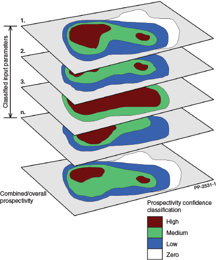
Due to the high level of data availability in the Cooper GBA region, relative prospectivity mapping was used to determine likely prospective play areas (Salter et al. 2014; Royal Dutch Shell 2017). The key geological properties required to assess prospectivity for each play type were identified in collaboration with state agencies (Department of the Premier and Cabinet, SA and Geological Survey of Queensland) and industry (Table 1). Quantitative data representing each geological property were classified according to the thresholds indicated in Table 1 and plotted to produce input parameter maps (Fig. 1). The classified data were then multiplied together to construct a composite map, highlighting the relative prospectivity over the assessment area for each play type by formation (Fig. 1). In addition, a combined relative prospectivity map for each play type was created by taking the maximum prospectivity value of the formation-based maps to capture overall shale, tight and deep coal gas prospectivity (Fig. 2). Further detail is available in the Stage 2 reports for the Cooper GBA region (Geological and Bioregional Assessment Program 2021b).

|
|

|
Areas of higher prospectivity were identified within most depocentres, including the Nappamerri, Patchawarra, Windorah, Allunga and Wooloo troughs, consistent with recent exploration activity (Fig. 2). The relative prospectivity maps inform where the plays are most likely to be present within the basin (Fig. 2).
Beetaloo GBA region
The Beetaloo GBA region boundary is located at the extent of the Mesoproterozoic Beetaloo Subbasin, as formally defined by the Department of Primary Industry and Resources (NT) (2017). Outside this boundary, the subbasin’s sedimentary fill shallows towards the surface, and in many areas, becomes extensively faulted and deformed, with limited data available for assessing petroleum prospectivity. The Beetaloo Subbasin is divided into eastern and western elements by the Daly Waters High and is overlain by the Neoproterozoic to Paleozoic Georgina, Wiso and Daly Basins and the Mesozoic Carpentaria Basin. The Beetaloo Subbasin is prospective for unconventional petroleum and is estimated to contain significant resources, particularly within the shales of the Kyalla and Velkerri formations. Three play types were assessed in the Beetaloo GBA region:
Velkerri formation (Amungee member) dry gas play.
Velkerri formation (Amungee member) liquids-rich gas play.
Kyalla formation liquids-rich gas play.
The extent of a fourth play type, the Hayfield sandstone member liquids-rich gas play, was derived from Côté et al. (2018) as there were insufficient public domain data to assess this play distribution.
Due to data limitations, likely prospective play areas in the Beetaloo GBA region were determined through the use of play fairway analysis rather than prospectivity mapping (Hall et al. 2020). Play fairway analysis was used to identify areas where specific petroleum plays are likely to be present, based on key selected geological parameters (Table 1). The resulting classified maps were multiplied together to produce an overall relative prospectivity map for each play type, which highlights regions with the most favourable geological conditions for play presence (Figs. 1 and 3).

|
Results demonstrate that the Amungee member of the Velkerri formation is potentially prospective for either liquids-rich or dry gas over most of the Beetaloo Subbasin extent (Fig. 3). The Kyalla formation liquids-rich gas play and the Hayfield sandstone member liquids-rich gas/oil play are primarily restricted to the central part of the eastern subbasin (Fig. 3). Further detail is available in the Stage 2 reports for the Beetaloo GBA region (Geological and Bioregional Assessment Program 2021a).
Isa GBA region
The Isa GBA region was defined as the area of the Paleo-Mesoproterozoic Isa Superbasin that contains an identified shale gas system from which future development could result in delivery of gas within 5–10 years (Lewis et al. 2020). The full extent of the Isa Superbasin is currently unknown, though it is likely to extend under the Mesoproterozoic South Nicholson Basin into the northern territory (Carr et al. 2020). Resource development companies are currently pursuing shale gas plays hosted within proven Paleoproterozoic petroleum systems. Two plays were assessed in the Isa GBA region:
Lawn supersequence shale gas play.
River supersequence shale gas play.
As with the Beetaloo GBA region, data for assessing play prospectivity is limited in the Isa GBA region. Hence, play fairway analysis was used to map the distribution of known Isa Superbasin shale gas plays. Map data were only available for two geological properties: net source rock thickness and formation depth (used as a proxy for source rock thermal maturity) (Table 1). These key mapped properties were classified based on defined criteria (Bailey et al. 2020), with the resulting classified maps multiplied together to produce play extent maps (Fig. 3). These maps highlight, based on the available data, regions with the most favourable geological conditions for shale gas plays. They demonstrate that the River supersequence is potentially prospective for shale gas over most of the Isa GBA region, whereas the Lawn supersequence is most likely prospective over the central and eastern parts of the region. Further detail is available in the Stage 2 reports for the Isa GBA region (Geological and Bioregional Assessment Program 2021c).
Summary
As part of the Australian Government’s GBA Program, Geoscience Australia has undertaken detailed studies on the stratigraphic and structural architecture of defined regions within three highly prospective onshore petroleum basins. A relative prospectivity mapping process has been undertaken in these regions, identifying and mapping the likely extent of shale, tight and deep coal gas plays. These maps provide key inputs into Stage 3 of the GBA program, indicating areal and stratigraphic constraints that support further work on likely development scenarios, impact assessments and causal pathways for each GBA region.
Conflicts of interest
All authors confirm that there are no conflicts of interest.
Declaration of funding
This research was funded through the Australian Government Department of Agriculture, Water and the Environment Geological and Bioregional Assessment Program.
Acknowledgements
The authors would like to acknowledge Amber Jarrett, Liuqi Wang, Tehani Palu, Sam Buchanan, Jennie Totterdell, Éamon Lai, Robert Langford, Baskaran Sundaram, Tim Ransley, Martin Smith, Tim Evans, Nigel Skeers, Dave Arnold, Chris Evenden, Adrian Dehelean, Bianca Reese, Murray Woods, Chris Inskeep, Chris, Lawson, Kriton Glenn, Aaron Heugh, Ron Zhu, Gilmore Stewart, Donna Cathro and Merrie-Ellen Gunning for their contributions to the rapid regional prioritisation of basins and to the geology and prospectivity appendices of Stage 2 of the geological and bioregional assessments. The authors would also like to thank our partners in the state and territory surveys, as well as the CSIRO, the Bureau of Meteorology and the Australian Government Department of Agriculture, Water and the Environment. This study is published with the permission of the CEO, Geoscience Australia. ECat 145124
References
Bailey, A. H. E., Bradshaw, B. E., Palu, T. J., Wang, L., Jarrett, A. J. M., Orr, M. L., Lech, M. E., Evenden, C., Arnold, D., Reese, B., Skeers, N., Woods, M., Dehelean, A., Lawson, C., and Hall, L. S. (2020). Shale gas prospectivity of the Isa GBA region. Technical appendix for the geological and bioregional assessment: stage 2. Department of the Environment and Energy, Bureau of Meteorology, CSIRO and Geoscience Australia, Australia.Carr, L. K., Southby, C., Henson, P., Costello, R., Anderson, J., Jarrett, A. J. M., Carson, C., Gorton, J., Hutton, L., Troup, A., Williams, B., Khider, K., Bailey, A., and Fomin, T. (2020). Exploring for the future: South Nicholson Basin geological summary and seismic data interpretation. Geoscience Australia, Canberra.
Côté, A., Richards, B., Altmann, C., Baruch, E., and Close, D. (2018). Australia’s premier shale basin: five plays, 1 000 000 000 years in the making APPEA Journal 58, 799–804.
| Australia’s premier shale basin: five plays, 1 000 000 000 years in the makingCrossref | GoogleScholarGoogle Scholar |
Department of Primary Industry and Resources (NT) (2017). Submission 479 to the scientific inquiry into hydraulic fracturing in the northern territory. Available at https://frackinginquiry.nt.gov.au/?a=464723 last accessed 11 January 2019.
Geological and Bioregional Assessment Program (2021a). Beetaloo GBA region. Available at https://www.bioregionalassessments.gov.au/assessments/geological-and-bioregional-assessment-program/beetaloo-gba-region last accessed 11 February 2021.
Geological and Bioregional Assessment Program (2021b). Cooper GBA region. Available at https://www.bioregionalassessments.gov.au/assessments/geological-and-bioregional-assessment-program/cooper-gba-region last accessed 11 February 2021.
Geological and Bioregional Assessment Program (2021c). Isa GBA region. Available at https://www.bioregionalassessments.gov.au/assessments/geological-and-bioregional-assessment-program/isa-gba-region last accessed 11 February 2021.
Hall, L. S., Buchanan, S., Totterdell, J. M., Lai, É. C. S., Langford, R. P., Sundaram, B., Ransley, T. R., Glenn, K. C., Heugh, A., Inskeep, C., Zhu, R., Skeers, N., and Stewart, G. (2018). Rapid regional prioritisation for tight and shale gas potential of eastern and northern Australian basins. Geological and bioregional assessment program: stage 1. Geoscience Australia for the Department of the Environment and Energy, Australia.
Hall, L. S., Wang, L., Bailey, A. H. E., Orr, M. L., Owens, R., Jarrett, A. J. M., Lech, M. E., Skeers, N., Reese, B., and Woods, M. (2020). Petroleum prospectivity of the Beetaloo Sub-basin. Technical appendix for the geological and bioregional assessment: stage 2. Department of the Environment and Energy, Bureau of Meteorology, CSIRO and Geoscience Australia, Australia.
Holland, K. L., Brandon, C., Crosbie, R. S., Davies, P., Evans, T., Golding, L., Gonzalez, D., Gunning, M. E., Hall, L. S., Henderson, B., Kasperczyk, D., Kear, J., Kirby, J., Lech, M. E., Macfarlane, C., Martinez, J., Marvanek, S., Merrin, L. E., O’Grady, A., Owens, R., Pavey, C., Post, D., Rachakonda, P., Raiber, M., Sander, R., Stewart, S., Sundaram, B., Tetreault-Campbell, S., Williams, M., Zhang, Y., and Zheng, H. (2020). Geological and environmental baseline assessment for the Cooper GBA region. Geological and bioregional assessment program: stage 2. Department of the Environment and Energy, Bureau of Meteorology, CSIRO, Geoscience Australia, Australia.
Lech, M. E., Wang, L., Hall, L. S., Bailey, A., Palu, T., Owens, R., Skeers, N., Woods, M., Dehelean, A., Orr, M. L., Cathro, D., and Evenden, C. (2020). Shale, tight and deep coal gas prospectivity of the Cooper Basin. Technical appendix for the geological and bioregional assessment: stage 2. Department of the Environment and Energy, Bureau of Meteorology, CSIRO and Geoscience Australia, Australia.
Lewis, S. J., Bailey, A. H. E., Bradshaw, B. E., Brandon, C., Buchanan, S., Crosbie, R. S., Dixon-Jain, P., Golding, L., Henderson, B. L., Kear, J., Kirby, J. K., MacFarlane, C. M., Martinez, J., Merrin, L. E., Murray, J., O’Grady, A. P., Orr, M. L., Pavey, C. R., Rachakonda, P. R., Raiber, M., Skeers, N., Tetreault-Campbell, S., Williams, M., and Woods, M. (2020). Geological and environmental baseline assessment for the Isa GBA region. Geological and bioregional assessment program: stage 2. Department of the Environment and Energy, Bureau of Meteorology, CSIRO and Geoscience Australia, Australia.
Orr, M. L., Bernardel, G., Owens, R., Hall, L. S., Skeers, N., Reese, B., and Woods, M. (2020a). Geology of the Beetaloo GBA region. Technical appendix for the geological and bioregional assessment: stage 2. Department of the Environment and Energy, Bureau of Meteorology, CSIRO and Geoscience Australia, Australia.
Orr, M. L., Bradshaw, B. E., Bernardel, G., Palu, T. J., Hall, L. S., Bailey, A. H. E., Skeers, N., Dehelean, A., Reese, B., and Woods, M. (2020b). Geology of the Isa GBA region. Technical appendix for the geological and bioregional assessment: stage 2. Department of the Environment and Energy, Bureau of Meteorology, CSIRO and Geoscience Australia, Australia.
Owens, R., Hall, L., Smith, M., Orr, M., Lech, M., Evans, T., Skeers, N., Woods, M., and Inskeep, C. (2020). Geology of the Cooper GBA region. Technical appendix for the geological and bioregional assessment: stage 2. Department of the Environment and Energy, Bureau of Meteorology, CSIRO and Geoscience Australia, Australia.
Royal Dutch Shell (2017). Play based exploration: a guide for Aapg’s imperial barrel award participants. Available at https://iba.aapg.org/Portals/0/docs/iba/Play_Based_ExplorationGuide.pdf last accessed 11 February 2021.
Salter, R., Meisenhelder, J., Bryant, I., and Wagner, C. (2014). An exploration workflow to improve success rate in prospecting in unconventional emerging plays. Paper presented at the SPE/AAPG/SEG Unconventional Resources Technology Conference, Denver, Colorado, USA, August 2014.

Dr Lisa S. Hall is a Senior Geoscientist at Geoscience Australia, with nearly 20 years of professional experience working across the resources and environmental sectors. She holds a PhD in geology from Oxford University and MSc in geology and geophysics from Cambridge. Lisa is currently working as Director of Operations for the Digital Earth Africa program. |

Dr Meredith L. Orr holds a BSc (Hons) from the Australian National University and a PhD in Earth Sciences from The University of Melbourne. She gained 10 years of experience in multidisciplinary research and teaching at Monash University before joining Geoscience Australia. This experience in integrating scientific disciplines informed her contribution to the Geological and Bioregional Assessment Program. Meredith currently works as an Energy Resources Geoscientist in Geoscience Australia’s Minerals, Energy and Groundwater Division. |

Megan E. Lech holds a BSc (honours) in geology ANU and an MSc in petroleum geoscience from Royal Holloway University of London. As a Basin Analyst at Geoscience Australia, she worked on numerous regional conventional/unconventional petroleum prospectivity, and CO2 storage assessments in frontier and well-explored Australian onshore and offshore sedimentary basins. She also coordinated the offshore Petroleum Acreage Release program and provided input into Geoscience Australia’s regional geochemical surveys. Since retiring in 2020, Megan has two six-month holidays per year and enjoys volunteering at Mulligans Flat Woodland Sanctuary, hiking, baking sourdough bread and training a labradoodle puppy. |

Dr Steve Lewis currently works as a Geologist within the Groundwater Geoscience team at Geoscience Australia. Graduating from RMIT University in the mid-90s, and with an Honours degree from the University of Tasmania, Steve started his career as a Diamond Exploration Geologist with Ashton Mining working in northern Australia and West Africa. Following his PhD at the University of Tasmania Steve started with Geoscience Australia in 2006 and has recently worked on regional-scale multidisciplinary geoscience investigations including the Geological and Bioregional Assessment Program. |

Dr. Adam H.E. Bailey is a Petroleum Geoscientist at Geoscience Australia, with expertise in petroleum geomechanics, structural geology and basin analysis. He was graduated with a BSc (Hons) in 2012 and a PhD in 2016 from the Australian School of Petroleum at the University of Adelaide. Working with the Onshore Energy Systems team at Geoscience Australia, Adam is currently working on the flagship exploring for the Future Program in Northern Australia, and is the Geology Discipline lead for the Geological and Bioregional Assessment Program. |

Dr. Ryan Owens is a Geoscientist in Geoscience Australia’s Minerals, Energy and Groundwater Division, Advice, Investment Attraction and Analysis Branch. He was graduated from the Australian National University in 2007 with a BSc in Geology (Hons). Subsequently he worked in mineral exploration before undertaking a PhD in paleoceanography at the Research School of Earth Sciences, ANU. Since joining Geoscience Australia through the graduate program in 2014, Ryan has contributed to a number of projects including the northern Houtman Sub-basin prospectivity study, the geological and bioregional assessments of the Beetaloo and Cooper basins, and the annual Acreage release. Member: PESA, GSA. |

Dr. Barry E. Bradshaw is a Geoscientist with 29 years of experience undertaking geological and geophysical studies and play-based prospectivity studies for conventional and unconventional hydrocarbon resources, geological storage projects and sediment-hosted mineral deposits. Barry is currently employed as the Energy Resources Advice activity leader at Geoscience Australia, and has previously worked as a Principal Geologist at CGSS consultants, Senior Research Scientist at AGSO/Geoscience Australia and Research Scientist at Texas A&M University (the United States). Barry was graduated from the University of Sydney in 1988, and completed a PhD in Earth Sciences at the University of Waikato (New Zealand) in 1991. |

George Bernardel is a Geoscientist in the Offshore Energy Systems section in the Minerals, Energy and Groundwater Division of Geoscience Australia. He gained his BSc (Honours) in Geophysics from the University of Sydney in 1986 and joined Geoscience Australia in 1995. His current role in the project is the seismic mapping of Cretaceous sequences and structure across the offshore Otway Basin. |