

Demonstrating an acceptable level of impact: an assessment of noise impacts to fishes from a seismic survey in an Australian Marine Park
Joe Edgell A D , Jeremy Colman A , Samantha Jarvis B and Ollie Glade-Wright CA ERM Australia Pty Ltd, Level 18, 140 St George’s Terrace, Perth, WA 6000, Australia.
B S2 Services Pty Ltd, 7 Chilton St, Willagee, WA 6156, Australia.
C Cooper Energy, Level 8, 70 Franklin Street, Adelaide, SA 5000, Australia.
D Corresponding author. Email: joe.edgell@erm.com
E Presenter only: Bethan Parnum. Email: bethan.parnum@erm.com
The APPEA Journal 59(1) 70-81 https://doi.org/10.1071/AJ18152
Submitted: 21 January 2019 Accepted: 7 March 2019 Published: 17 June 2019
Abstract
A key challenge of the environmental regulatory framework for offshore petroleum activities in Australia is the requirement to demonstrate acceptability, with the legislation placing the onus on petroleum titleholders to demonstrate that the impacts and risks posed by an activity will be of an acceptable level and reduced to as low as reasonably practicable. This paper presents a case study on the assessment of noise impacts to fishes for the Bethany 3D Marine Seismic Survey, which was acquired by Santos Ltd in mid-2018. The survey area was encompassed entirely by the Oceanic Shoals Marine Park, and also overlapped a significant proportion of the Timor Reef Fishery, a regionally important demersal scalefish fishery. The survey area overlapped a key ecological feature and a range of geomorphic features characterised by benthic habitats supporting demersal and benthic fish communities, including site-attached species. On this basis, the evaluation of impacts and risks required a multi-faceted approach, with seven key elements: (1) acoustic modelling; (2) application of sound exposure guidelines; (3) a quantitative risk assessment (benthic habitat predictive modelling and spatial analysis of site-attached fish assemblages); (4) the definition of an acceptable level of impact; (5) a sound source verification process; (6) engagement with key stakeholders; and (7) an independent, expert peer review process. The outcomes of each of these steps were incorporated into the environment plan, and enabled the titleholder to demonstrate that, with adopted control measures in place, environmental impacts and risks from the seismic survey could be managed to an acceptable level.
Keywords: demonstration of acceptable level, environment plan, marine seismic survey, NOPSEMA, Oceanic Shoals Marine Park, site-attached fish assemblages, sound exposure guidelines, sound source verification, stakeholder engagement, Timor Reef Fishery, underwater noise impact assessment.
Introduction
The Bethany 3D Marine Seismic Survey (MSS) was undertaken by Santos Ltd (Santos) between May and July 2018. The survey was located in Australian Commonwealth waters off the Northern Territory coast, ~250 km north-west from Darwin (Fig. 1).

|
The survey was located entirely within the Oceanic Shoals Marine Park, which is characterised by a range of geomorphic features and associated benthic habitats. These features include shallow banks that support benthic and demersal fish communities, including site-attached fish assemblages. The survey also overlapped a significant proportion of the Timor Reef Fishery, a regionally important demersal scalefish fishery that targets demersal snapper and emperor species. Given the complexity and potential sensitivity of the environment, before the Bethany survey receiving regulatory approval, a multi-faceted and scientifically rigorous approach was required to determine if the survey could be managed to an acceptable level of impact and in a manner that was consistent with the principles of ecologically sustainable development (ESD).
This paper presents the various methods that were adopted by Santos to demonstrate that the potential environmental impacts and risks of the Bethany survey would be of an acceptable level.
Overview of the Bethany 3D MSS activity
The Bethany 3D MSS was undertaken over the NT/P85 and NT/P82 petroleum exploration permits in the Bonaparte Basin (Fig. 1). The survey involved a typical 3D seismic survey approach similar to others conducted in Australian waters and globally, whereby a seismic survey vessel towed a seismic acoustic source and an array of hydrophone receivers (streamers) in a ‘racetrack’ formation of parallel survey lines over the permit areas. The survey used a 2380 in3 seismic source, discharged at 12.5 m intervals as the survey vessel sailed along the survey lines at a speed of ~4.5 kn. The survey area was defined by a 4565 km2 ‘full power zone’ (FPZ), where the full power seismic acquisition took place, with a larger operational area to allow for the vessel turns (Fig. 1).
Environmental setting and key sensitivities
The Bethany survey was located in water depths ranging from ~20 to 200 m. Several relatively shallow banks with water depths less than 40 m were present in the southern part of the FPZ (Fig. 2). The seabed in the northern part of the FPZ consists of terrace habitat, which is located in intermediate water depths (48–101 m) and is relatively flat and featureless. The banks and terrace system is interspersed by deep valleys and depressions.

|
The bank features within the Bethany survey area and surrounding region are a characteristic of a large-scale key ecological feature (KEF) called the ‘Carbonate bank and terrace system of the Van Diemen Rise’, which is also a conservation value of the Oceanic Shoals Marine Park. The Bethany survey overlapped the Multiple Use Zone and Special Purpose Zone of the Oceanic Shoals Marine Park (Fig. 3). Both zones are classified as International Union for the Conservation of Nature (IUCN) Category VI reserves. Petroleum exploration activities are allowable in these zones subject to receiving regulatory authorisation and the petroleum titleholder demonstrating that activities will be conducted with specific regard to the values of the marine park and associated management arrangements (NOPSEMA 2018a).

|
The bank features in this region are predominantly composed of sand and low-lying rock outcrops supporting relatively complex and diverse epibenthic assemblages of sponges, octocorals and hard corals along with smaller colonies of bryozoan and ascidians (Anderson et al. 2011). These benthic assemblages were identified by Santos as having the potential to support site-attached fish assemblages. Site-attached fishes rely on the benthic habitat and demonstrate a very high degree of site fidelity (Ault and Johnson 1998). Most site-attached fish species are generally small- to medium-sized, are unlikely or unable to flee an approaching seismic sound source and are instead likely to remain and/or seek refuge within habitat structures. This trait means that site-attached fishes have the potential to be exposed to high sound levels in close proximity to the seismic source, which could result in mortality, physical injury or hearing impairment effects.
The habitats in this region also support commercially targeted demersal fish species including snappers and emperors, which are of value to the Timor Reef Fishery. Although these species may also exhibit habitat preferences and some fidelity to an area, they can be found across a variety of habitats and are typically more mobile and have larger home ranges than smaller site-attached fishes (Moran et al. 2003; Parsons et al. 2011; Harasti et al. 2015). Therefore, they are more likely to exhibit an avoidance response to an approaching seismic source.
Environmental regulatory framework and ‘acceptable level’ of impact
Titleholders in Australian Commonwealth waters require an Environment Plan (EP) by the National Offshore Petroleum Safety and Environmental Management Authority (NOPSEMA) in accordance with the Offshore Petroleum and Greenhouse Gas Storage (Environment) Regulations 2009 before a petroleum activity can commence. The objective of the Regulations is to ensure that petroleum activities are carried out in a manner consistent with the principles of ESD, as set out in the Environment Protection and Biodiversity Conservation Act 1999 (EPBC Act), and carried out in a manner by which the environmental impacts and risks of the activity will be reduced to as low as reasonably practicable (ALARP) and to an acceptable level.
The regulations are objective-based and performance-based rather than prescriptive. The onus is placed on titleholders to identify and evaluate the environmental impacts and risks posed by an activity and determine the management measures and standards of environmental performance required to reduce the impacts and risks to both ALARP and acceptable levels (NOPSEMA 2016).
Titleholders are required to define an ‘acceptable level’ of impact, which can be challenging because each environmental receptor may have a different level of sensitivity or resilience to the changes (impacts and risks) caused by a petroleum activity (NOPSEMA 2018b). NOPSEMA expect that a titleholder’s definition and demonstration of an ‘acceptable level’ should give regard to all relevant considerations including, but not limited to (NOPSEMA 2016):
-
ESD principles;
-
legislative and other requirements (including laws, policies, standards and conventions);
-
internal context (e.g. consistent with titleholder policy, culture and company standards); and
-
external context (the existing environment and stakeholder expectations).
In relation to the ESD principles, the demonstration of acceptable levels of impact should consider both the long- and short-term effects on the environment and ensure the health, ecological integrity, diversity and productivity of the environment are conserved for future generations. In addition, where there is a threat of serious or irreversible environmental damage and scientific uncertainty as to the environmental damage, there is a need to apply the precautionary principle (NOPSEMA 2018b).
In the case of defining the acceptable level of impact for the Bethany survey, the applicable legislative requirements and external context included the Oceanic Shoals Marine Park values and IUCN management principles1. External context also gave consideration to the concerns of Timor Reef Fishery stakeholders.
Approach to demonstrating an acceptable level of impact
The evaluation of impacts and risks and demonstration of acceptable levels of impact from the Bethany survey on site-attached fish assemblages and the Timor Reef Fishery comprised seven key elements:
-
acoustic modelling;
-
application of sound exposure guidelines;
-
quantitative risk assessment, involving benthic habitat predictive modelling and spatial analysis of site-attached fish assemblages;
-
definition of an acceptable level of impact;
-
sound source verification process;
-
engagement with key stakeholders in the Timor Reef Fishery; and
-
independent, expert peer review process.
The method adopted by Santos provides an example of the level of detail and rigour required to demonstrate that the environmental impacts and risks posed by the activity will be of an acceptable level relative to the sensitivity of the receiving environment and also to the activity’s scale (time and space), complexity and its potential and actual environmental consequences.
Acoustic modelling
Acoustic modelling was undertaken by JASCO Applied Sciences to predict the sound levels produced by the seismic source, sound propagation and the potential extent over which different receptors may be exposed to sound. The acoustic modelling approach is one that has been applied in several other EPs for seismic surveys in Australian waters.
Modelling included an assessment of both instantaneous sound pressures produced from a single seismic pulse and the cumulative sound exposure levels resulting from multiple pulses over a 24-h period. In the context of potential impacts to fishes, the modelling was used to assess the ranges at which physical injury, hearing impairment and behavioural effects may occur. This required careful consideration of sound exposure guidelines appropriate to seismic surveys and different groups of fishes, including the potential for injury or mortality to site-attached fishes, as described below.
Application of sound exposure guidelines
Some of the most recent and frequently referenced exposure guidelines applied in the assessment of underwater noise impacts from seismic surveys to fishes are those developed by the Working Group on the Effects of Sound on Fish and Turtles. In their American National Standards Institute (ANSI) accredited report (Popper et al. 2014), sound exposure guidelines are presented for different levels of effects in three categories of fishes based on their hearing sensitivity:
-
Fishes with no swim bladder or other gas chamber. These species are less susceptible to barotrauma and only detect particle motion, not sound pressure. However, some barotrauma may result from exposure to sound pressure.
-
Fishes with swim bladders in which hearing does not involve the swim bladder or other gas volume. These species are susceptible to barotrauma although hearing only involves particle motion, not sound pressure.
-
Fishes in which hearing involves a swim bladder or other gas volume (e.g. herring and relatives, Otophysi). These species are susceptible to barotrauma and detect sound pressure as well as particle motion.
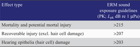
For seismic sources, Popper et al. (2014) provide the following sound exposure guidelines for mortality or potential mortal injury and recoverable injury in the three categories of fishes:
-
No swim bladder (particle motion detection): >213 dB re 1 μPa peak pressure (PK);
-
Swim bladder is not involved in hearing (particle motion detection): >207 dB re 1 μPa PK; and
-
Swim bladder involved in hearing (primarily pressure detection): >207 dB re 1 μPa PK.
At the time of writing, no quantified data on the effects from seismic sources on fishes had been reviewed by the Working Group. Therefore, the Popper et al. (2014) exposure guidelines for mortality or potential mortal injury and recoverable injury for adult and juvenile fishes exposed to seismic source emissions are based solely on data from pile driving conducted on predominantly temperate, freshwater fish species.
The rates and total number of pulses produced over a given period of time or area differ markedly between pile driving and marine seismic surveys. There are several reports and reviews in the literature noting the relatively rapid rise times of pile driving impulses (typically much faster than seismic pulses) and, unlike seismic surveys, evidence of fish kills and serious injuries to the organs and tissues of various fish species in the vicinity of pile driving operations (e.g. Caltrans 2001, 2004; Hastings and Popper 2005; Popper et al. 2006).
Environmental Resources Management Australia (ERM) undertook a detailed literature review of potential fish mortality and physical injury as a result of exposure to seismic sources (ERM 2017). A total of 28 papers or reports relating to the findings of experimental and opportunistic laboratory and in situ studies on mortality, potential mortal injury and physical damage effects of seismic source exposure on fishes, conducted worldwide between 1972 and 2014, were reviewed.
Of the studies covered in the literature review, only three observed direct mortality of exposed fish (Weinhold and Weaver 1972; Matishov 1992; Booman et al. 1996). In each case, mortalities occurred to caged fish at very close proximity to the seismic source (<2 m), which is not representative of real-life exposures. Nine studies covered in the literature review found some evidence of damage to one or more organs in exposed fish, including damage to swim bladders, ablated ear cells, internal bleeding or blindness. Most damage occurred upon exposure at distances up to 3–4 m from the source. None of these nine studies found any evidence of either direct or indirect mortality over the various post-exposure periods during which exposed fish were held in cages. The literature review found a further 16 studies that reported no mortality or physical damage in any fishes exposed to seismic pulses, including to fishes exposed in cages.
Of the studies reviewed by ERM (2017) that resulted in mortality, received levels ranged within 220–241 dB re 1 μPa PK. It is important to note that other studies reported no mortality, and in some cases no physical damage at levels up to 246 dB re 1 μPa PK. For example, Fanta (2004) found no mortality or physical damage in 15 different coral reef fish species exposed in cages to 215–235 dB re 1 μPa PK from a 3090 in3 commercial seismic array at a minimum distance of 45 m.
Following review and analysis of the received peak sound pressure levels reported in the different studies, ERM (2017) concluded that the 207–213 dB re 1 μPa PK guidelines in Popper et al. (2014) represent an overly precautionary approach in the assessment of potential injury and mortality effects from exposure to underwater noise from seismic sources and, therefore, caution is required when applying these sound exposure guidelines to marine seismic surveys in Australian waters.
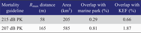
ERM (2017) recommended an alternative guideline of >215 dB re 1 μPa PK for mortality and potential mortal injury effects in fishes exposed to seismic pulses, while the lower 207 dB re 1 μPa guideline proposed by Popper et al. (2014) is expected to be indicative of recoverable injury (Table 1). These guidelines are considered to be more appropriate and credible than those provided in Popper et al. (2014), particularly for application in the assessment of potential mortality and injury impacts to site-attached fish assemblages resulting from the Bethany survey. Acoustic modelling for the Bethany survey indicated that the lower Popper et al. (2014) 207 dB re 1 μPa PK guideline may be exceeded up to maximum distance of 165 m horizontally from the centre of the seismic source, while the ERM (2017) 215 dB re 1 μPa PK mortality and potential mortal injury guideline may be exceeded between 39–58 m, depending on water depth.
|
Given that the reviewed literature reported that mortality and physical injury only occurred within a few metres of the seismic source and other studies observed no mortality or physical injury following exposure to significantly higher sound pressure levels than 215 dB re 1 μPa PK, the ERM guideline is considered to be conservative and provides for a precautionary approach.
Quantitative risk assessment and spatial analysis
To provide an indication of the potential extent of site-attached fish habitat present within the FPZ, and to quantify the potential impacts to these fish assemblages, Santos used predictive benthic habitat modelling and undertook an analysis of the potential spatial footprint of sound emissions from the Bethany survey.
Santos utilised existing benthic habitat modelling developed by Radford and Puotinen (2016) for the Oceanic Shoals Marine Park, using bathymetry data collected by Geoscience Australia and towed underwater video of the benthos collected by the Australian Institute of Marine Science (AIMS). In order to use this model to identify habitat types likely to support site-attached fishes within the FPZ, and to reduce uncertainties reported by AIMS for some classes of benthos in the original model prediction, all classes of benthos were grouped into two broad categories based on the likelihood of supporting site-attached species:
-
Abiotic substrate and burrowers/crinoids – unlikely to support site-attached fish species;
-
Alcyon, filterers, gorgonians, halimeda, hard coral, macroalgae, seagrass, soft coral and uUnknown – likely to support site-attached fish species.
To investigate the likelihood of these types of benthic habitat occurring within the FPZ, Santos contracted Jacobs to conduct a desktop assessment (Jacobs 2017). Jacobs prepared a map (Fig. 4) that overlaid the Radford and Puotinen (2016) habitat data with the FPZ, which indicated that ~23% of the FPZ was predicted to overlap the habitat category that could potentially support site-attached fish assemblages.

|
A list of potential fish families within the FPZ, based on the habitat categories present, was also compiled by reviewing the findings from other recent studies in the region (Jacobs 2016; Heyward et al. 2017; Moore et al. 2017) as well as by-catch data from the Timor Reef Fishery and images from AIMS/Geoscience Australia research surveys (Heap et al. 2010; Anderson et al. 2011). The fish families and species identified for the FPZ are well represented throughout the region.
The potential response of the identified fish families to seismic noise, as was observed or predicted by AIMS for different fish families at Scott Reef during the Woodside Maxima 3D MSS (Woodside Energy Ltd 2007), was assessed to determine their degree of site-attachment, using the following criteria:
-
Reef associated – generally reliant on reef structures (hard substrate with epibenthos communities) and unlikely to move away from isolated reef habitats;
-
Limited mobility – locomotion generally limited to crawling over the seabed so unlikely to be able to quickly move >200 m from the seismic source; and
-
Retreat response – Responds to threats by retreating into habitat (hiding in reef structure or burrowing into seabed) so may not move away from the seismic source.
It was confirmed that several of the families expected to occur in association with the FPZ were considered site-attached and so unlikely to move away from a seismic source.
Utilising GIS and a spatial analysis, a quantitative risk assessment process then examined the potential mortality and potential mortal injury impacts to site-attached fishes, based on the areas of relevant benthic habitat that may be exposed to sound pressures at the seabed in excess of the two mortality and potential mortal injury guidelines defined by Popper et al. (2014) and ERM (2017). The results of this analysis are presented in Table 2, including the modelled maximum horizontal range (Rmax) to impact, the total area of seabed habitat that may be exposed during the survey, and the relative percentage overlap with the Oceanic Shoals Marine Park and the KEF.
|
Definition of an acceptable level of impact
Having evaluated the potential impact footprint of the Bethany survey in terms of potential mortality or injury to site-attached fishes, it was necessary for Santos to put the results into context of an environmental baseline and define the criteria against which to determine if the impact will be of an acceptable level. In doing so, Santos and ERM considered natural rates of mortality in site-attached fish populations, as well as their resilience and recovery to a range of significant natural and anthropogenic disturbances.
The criterion for an acceptable level of impact was set at <5% mortality in the site-attached fish assemblages in the marine park and KEF. The criterion was based on research that indicates that tropical reef fish populations routinely fluctuate by 10% or more due to the normal vagaries in reproduction, recruitment and natural mortality from predation and other factors (Eckert 1987; Connell 1996; Woodside Energy Ltd 2007; Goatley and Bellwood 2016).
Coral reef fish assemblages are also known to exhibit high resilience and recovery to significant natural and anthropogenic disturbance, especially where the structural and biological integrity of the habitat is maintained and recruitment is possible from neighbouring habitat. For example, Planes et al. (2005) reported that fish assemblages rapidly recovered within 1–5 years following underground nuclear testing at Moruroa Atoll that caused the instantaneous removal of all fish over an area of 12 km2. Similarly, Syms and Jones (2000), Halford et al. (2004), Bellwood et al. (2006) and Lefèvre and Bellwood (2015) have observed rapid recovery and resilience in coral reef fish assemblages subject to a range of large-scale natural and anthropogenic disturbances.
On this basis, Santos concluded that the criterion of <5% mortality in site-attached fish assemblages was appropriate in the external context of the natural environment. The level of potential mortality or injury to site-attached fish assemblages in the Oceanic Shoals Marine Park (predicted to be <1%; Table 2) and the KEF (predicted to be <2%; Table 2) is well within natural variation, and impacts to assemblage structure are expected to be recoverable through recruitment.
The criterion selected by Santos is consistent with the ESD principles as the predicted level of impact is reversible and would not be detrimental to the long-term ecological integrity, diversity and productivity of the banks and shoals in the region. It is also noted that the predicted acceptable level of impact includes the following levels of conservatism to address uncertainty, consistent with the precautionary principle:
-
The spatial analysis grouped several the benthic habitat classes, to which Radford and Puotinen (2016) had assigned a relatively poor level of accuracy, in the habitat category likely to support site-attached fishes and therefore habitat coverage predictions are considered to be conservative;
-
The Popper et al. (2014) and ERM (2017) sound exposure guidelines adopted by Santos are likely to be conservative, as the available research indicates that mortality and physical injury effects for many groups of fish are limited to within just a few metres of the seismic source;
-
The area used to determine the percentage of site-attached fish assemblages that may be exposed to mortality and potential mortality injury is based on the most conservative guideline (Popper et al. 2014) and assumes the furthest horizontal distance from the seismic source of all modelled locations (165 m); and
-
The predicted mortality of <2% is within the acceptable <5% criterion and well within larger natural variations in mortality.
The potential level of impact is also within an acceptable level in the legislative context, being consistent with IUCN Category VI reserve management principles, where the Oceanic Shoals Marine Park will be used in an ecologically sustainable manner and the biological diversity and other natural values of the marine park will remain protected in the long-term.
Sound source verification
As the Bethany survey was to be undertaken within a particularly sensitive marine environment and because the assessment of potential impacts to site-attached fish was based on model predictions, Santos stipulated within the EP that the seismic contractor would undertake sound source verification before commencing the survey. The purpose of this was to verify that the source levels generated by the selected 2380 in3 seismic source matched those specified in the modelling and therefore reduce uncertainty and provide confidence in the accuracy of the model predictions.
Ground-truthing of received sound levels was also considered, but the process of ground-truthing differs markedly from sound source verification. Sound source verification involves conducting a field measurement program which concentrates on understanding the sound source itself, rather than what the received levels are in a specific location. Therefore, a sound source verification study typically involves measurements at close range to minimise the influence of the measurement environment. Ground-truthing of received levels, however, is more sensitive to differences in the regional environment, including sound speed profile, seabed geology and bathymetry and so requires measurements to be undertaken in the same location as the modelling or at a location with similar characteristics in order to be relevant. A reliable comparison is also difficult without interrogation of the measured data to validate and re-run the model. While it is possible to conduct ground-truthing of far-field received levels (e.g. Bröker et al. 2015; Racca et al. 2015; Nowacek and Southall 2016), ground-truthing cannot be conducted in short timeframes to inform adaptive mitigation. Further explanation of the merits and limitations of different ground-truthing methods is covered in the Report of the Acoustic Ground-Truthing Technical Working Group as part of New Zealand’s 2015–2016 Seismic Code of Conduct Review process (Department of Conservation 2016).
A sound source verification process was therefore selected by Santos and was considered appropriate for providing a reasonable degree of confidence in the sound levels close to and beneath the seismic source, as limited variation in sound propagation is likely to occur over the short distances associated with potential impacts to site-attached fish.
Owing to the time required to undertake the measurements and verification process, and the potential cost and delay to the survey if disparities between in situ measurements and modelled source levels were identified, it was necessary to undertake the sound source verification before mobilisation of the survey vessel for the Bethany 3D MSS. The validation program was conducted by JASCO Applied Sciences in an area of relatively flat seabed in 80 m of water in the Timor Sea during the Polarcus Zénaïde 3D MSS. Measurements were taken with the seismic source passing directly over an autonomous recorder located on the seabed and then making passes offset at several pre-determined distances from the recorder. Measurements quantified the received sound levels from each impulse in the vertical, broadside and endfire directions. To validate the source model, the measured received sound levels were compared against predicted received sound levels at points in the near and far-field of the source.
A restrictive benchmark was set for the validation study, with only 10% of the measured values being allowed to exceed the modelling predictions by more than 3 dB. This was considered restrictive due to factors such as the limited available information about the seafloor geology, the accuracy of the location and azimuth of the autonomous recorder compared to the seismic source, and variations within the seismic source array itself, all of which can influence the results of the measurement program. However, this benchmark was achieved, and the results of the sound source verification showed good agreement with the modelling results, validating the source specifications and modelled source signature provided in the EP and allowing the Bethany 3D MSS to proceed.
Since the sound source verification, JASCO Applied Sciences has also undertaken further analysis of the acoustic data in order to compare measured and modelled received levels (McPherson et al. 2018). Again, the measured data showed good agreement with the modelling, with the mean residual difference between measured and modelled sound exposure levels (SEL) being less than 2 dB (McPherson et al. 2018). The maximum measured sound level directly beneath the seismic source was 220.6 dB re 1 µPa PK, indicating that model predictions of the horizontal ranges to potential mortality and mortal injury guidelines were reliable.
Engagement with key stakeholders
During development of the EP, concerns were raised by stakeholders in the Timor Reef Fishery about the potential impacts of the Bethany survey to demersal fish species targeted by the fishery, as well as potential disruption of their activities and loss of catch.
The issue of potential fish mortality or injury that was evaluated for site-attached fishes is not expected to occur to other more mobile (non-site-attached) pelagic and demersal fish species, including the species targeted by the Timor Reef Fishery. Impacts to demersal fishes, such as snappers and emperors, are more likely to be behavioural, including temporary avoidance of an area exposed to high sound levels. Consequently, it was acknowledged that there may be some temporary and localised effects to the behaviour and distribution of demersal fishes in proximity to the FPZ during the survey.
In addition, stakeholders from the fishery expressed concerns that exposure to the sounds from the survey may result in hearing impairment of fishes, including temporary hearing loss (temporary threshold shift; TTS) and other effects associated with exposures to multiple pulses from the seismic source (cumulative sound exposure levels; SELcum). They also queried the appropriateness of a 24-h period used in the predictive modelling to assess the potential for TTS from SELcum, which is a common approach in underwater noise environmental impact assessment.
Following extensive consultation and attempts to answer these queries and concerns, Santos commissioned an independent, expert peer review of aspects relating to the concerns raised, to provide stakeholders with sufficient clarification and assurance. Santos engaged a global leading expert in underwater noise and the effects on fishes, Professor Arthur Popper. Complete transparency with the stakeholders was seen as essential and they were put in direct contact with Professor Popper so that they could ask questions directly and have input on the issues they wished to be addressed. The outcomes of the peer review are outlined below.
The consultation undertaken with stakeholders in the Timor Reef Fishery during the development of the EP was extensive, extending over a period of 36 months. Therefore, the numerous attempts made by Santos to address stakeholder concerns and their engagement of Professor Popper was another key step taken towards demonstrating that stakeholder concerns had been adequately addressed and that impacts would be acceptable.
Independent expert peer review process
The peer review by Popper (2018) was undertaken to provide fisheries stakeholders with a direct line of contact with an independent expert in order to have their queries regarding cumulative sound exposures addressed. In response to specific questions raised by the stakeholders, JASCO Applied Sciences was also engaged to provide additional model outputs that were used to demonstrate some of the concepts described in the peer review and aid understanding.
In relation to concerns regarding the potential for cumulative sound exposure impacts and the appropriateness of using a 24-h SELcum scenario to assess the potential for such impacts, the Popper (2018) review concluded that:
-
It is highly unlikely that there would be physical damage to fishes as a result of the survey unless the animals are very close to the source (perhaps within a few metres). As the demersal fish species targeted by the Timor Reef Fishery are free swimming and able to move, such exposures were not expected.
-
The most likely effect (if any) to fishes resulting from cumulative sound exposure is TTS. However:
Most commercially targeted demersal fishes in the region, being species that do not have hearing specialisations, are not likely to have much (if any) TTS as a result of the Bethany 3D survey.
If TTS does take place, the duration of exposure to the most intense sounds that could result in TTS will be over just a few hours. Thus, accumulation of energy over longer periods than a few hours is probably not appropriate.
If TTS takes place, its level is likely to be sufficiently low that it will not be possible to easily differentiate it from normal variations in hearing sensitivity.
Even if fishes do show some TTS, recovery will start as soon as the most intense sounds end, and recovery is likely to even occur, to a limited degree, between seismic pulses. Based on very limited data, recovery within 24 h (or less) is very likely.
-
Nothing is known about the behavioural implications of TTS in fishes in the wild. However, since the TTS is likely very transitory, the likelihood of it having a significant impact on fish fitness is very low.
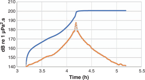
-
The time over which SELcum should be accumulated should be limited to the time over which fishes get maximum exposure e.g. a few hours (Fig. 5). Thus, 24 h is likely to be a conservative period for calculation of accumulated energy and the potential for damage or TTS. There is no scientific basis for longer periods than 24 h.
|
Fishery stakeholders also commissioned their own study to explore SELcum modelled for different acquisition scenarios and durations, which was undertaken by Curtin University’s Centre of Marine Science and Technology (Duncan 2018). The study correctly indicated that modelled SELcum increases when modelled for multiple passes of the seismic array over periods longer than 24 h, but also confirmed that the main contribution to accumulated energy occurred at relatively close range and over a relatively short period of time (e.g. a few hours). Santos and ERM provided further explanation to fishery stakeholders about why it is important to consider how much of the sound is actually heard by individual fish in a population and their likely recovery from temporary effects after exposure.
The Popper (2018) peer review is publicly available as part of the EP Summary on the NOPSEMA website, and provides further detailed explanation of the SELcum issues addressed for stakeholders. The peer review was also directly referenced by NOPSEMA in their ‘Statement of Reasons’ for its decision to accept the Bethany survey EP, which highlighted the value and weight of evidence that an independent and expert review can provide.
Summary and conclusions
The Bethany 3D MSS was a relatively complex seismic survey to assess given its location within the Oceanic Shoals Marine Park, overlap with a KEF and bank features that potentially support site-attached fish, and overlap with the Timor Reef Fishery. Therefore, the approach selected required several different components, including modelling, research into appropriate sound exposure guidelines, spatial analysis, sound source verification, an extensive program of stakeholder engagement, and an independent expert peer review process. The methods adopted by Santos during the development of the Bethany 3D MSS EP provide an example of the level of effort required to demonstrate that impacts and risks from a relatively complex seismic survey with several sensitive receptors will be of an acceptable level.
The outcome of this approach was an EP that successfully demonstrated that the impacts and risks to fishes within an Australian Marine Park could be appropriately managed to an acceptable level.
Conflicts of interest
The authors declare no conflicts of interest.
Acknowledgements
The authors would like to thank Santos Ltd for permission to publish this paper and the use of material derived from the Bethany 3D MSS EP. ERM was contracted by Santos to support the preparation of the Bethany 3D MSS EP and help manage the environmental aspects of the survey. Samantha Jarvis and Ollie Glade-Wright were employees of Santos at the time the Bethany 3D MSS EP was developed but have since been employed by S2 Services and Cooper Energy respectively. We appreciate Santos giving permission for this work to be published. The research did not receive specific funding.
References
Anderson, T. J., Nichol, S., Radke, L., Heap, A. D., Battershill, C., Hughes, M., Siwabessy, P. J., Barrie, V., Alvarez de Gasby, B., Tran, M., and Daniell, J. (2011). Seabed Environments of the Eastern Joseph Bonaparte Gulf, Northern Australia. Post Survey Report. Geoscience Australia, Canberra.Ault, T. R., and Johnson, C. R. (1998). Spatially and temporally predictable fish communities on coral reefs. Ecological Monographs 68, 25–50.
Bellwood, D. R., Hoey, A. S., Ackerman, J. L., and Depczynski, M. (2006). Coral bleaching, reef fish community phase shifts and the resilience of coral reefs. Global Change Biology 12, 1587–1594.
| Coral bleaching, reef fish community phase shifts and the resilience of coral reefs.Crossref | GoogleScholarGoogle Scholar |
Booman, C., Dalen, J., Leivestad, H., Levsen, A., van der Meeren, T., and Toklum, K. (1996). Effekter av luftkanonskyting på egg, larver og yngel. Fisken og havet. Undersøkelser ved Havforskningsinstituttet og Zoologisk laboratorium, UIB. [In Norwegian with English Summary].
Bröker, K., Gailey, G., Muir, J., and Racca, R. G. (2015). Monitoring and impact mitigation during a 4D seismic survey near a population of gray whales off Sakhalin Island, Russia. Endangered Species Research 28, 187–208.
| Monitoring and impact mitigation during a 4D seismic survey near a population of gray whales off Sakhalin Island, Russia.Crossref | GoogleScholarGoogle Scholar |
Caltrans (2001). Fisheries impact assessment for the Pile Installation Demonstration Project, San Francisco – Oakland Bay Bridge East Span Seismic Safety Project. State of California Department of Transportation, San Francisco.
Caltrans (2004). Fisheries and Hydroacoustic Monitoring Program Compliance Report – San Francisco – Oakland Bay Bridge East Span Seismic Safety Project. State of California Department of Transportation, San Francisco.
Connell, S. D. (1996). Variations in mortality of a coral-reef fish: links with predator abundance. Marine Biology 126, 347–352.
| Variations in mortality of a coral-reef fish: links with predator abundance.Crossref | GoogleScholarGoogle Scholar |
Department of Conservation (DOC) (Ed.) (2016). Report of the Acoustic Ground-Truthing Technical Working Group. Marine Species and Threats, Department of Conservation, Wellington, New Zealand.
Duncan, A. (2018). A comparison study of cumulative sound exposure levels (CSELs) from typical 3D seismic surveys. Curtin University Centre for Marine Science and Technology, Perth.
Eckert, G. J. (1987). Estimates of adult and juvenile mortality for labrid fishes at One Tree Reef, Great Barrier Reef. Marine Biology 95, 167–171.
| Estimates of adult and juvenile mortality for labrid fishes at One Tree Reef, Great Barrier Reef.Crossref | GoogleScholarGoogle Scholar |
Environmental Resources Management Australia (ERM) (2017). ‘Bethany 3D Survey Environment Plan: Seismic Airguns & Fish Mortality Literature Review.’ (ERM, Perth.)
Fanta, E. (2004). Efeitos da sísmica com Cabo Flutuante em peixes tropicais de areas recifais. Relatório Tėcnico Universidade Federal do Paraná, Departamento de Biologia Celular, Grupo de Estudos de Impacto Ambienta. [Effects of Floating Cable Seismic on Tropical Fish in Reef Areas. Technical Report prepared by the Environmental Impact Study Group (GEIA) of Cellular Biology Department, University of Paraná, Curitiba, Brazil].
Goatley, C. H. R., and Bellwood, R. H. (2016). Body size and mortality rates in coral reef fishes: a three-phase relationship. Proceedings of the Royal Society B: Biological Sciences 283, 20161858.
| Body size and mortality rates in coral reef fishes: a three-phase relationship.Crossref | GoogleScholarGoogle Scholar |
Halford, A., Cheal, A. J., Ryan, D., and Williams, D. McB. (2004). Resilience to large-scale disturbance in coral and fish assemblages on the Great Barrier Reef. Ecology 85, 1892–1905.
| Resilience to large-scale disturbance in coral and fish assemblages on the Great Barrier Reef.Crossref | GoogleScholarGoogle Scholar |
Harasti, D., Lee, K. A., Gallen, C., Hughes, J. M., and Stewart, J. (2015). Movements, home range and site fidelity of snapper (Chrysophrys auratus) within a temperate marine protected area. PLoS One 10, e0142454.
| Movements, home range and site fidelity of snapper (Chrysophrys auratus) within a temperate marine protected area.Crossref | GoogleScholarGoogle Scholar | 26544185PubMed |
Hastings, M. C., and Popper, A. N. (2005). Effects of Sound on Fish. Technical report under Jones & Stokes for the California Department of Transportation, Sacramento, CA.
Heap, A. D., Przeslawski, R., Radke, L. C., Trafford, J., and Battershill, C. (2010). Seabed Environments of the Eastern Joseph Bonaparte Gulf, Northern Australia: Post Survey Report. Geoscience Australia, Canberra.
Heyward, A., Radford, B., Cappo, M., Wakeford, M., Fisher, R., Colquhoun, J., Case, M., Stowar, M., and Miller, K. (2017). Barossa Environmental Baseline Study, Regional Shoals and Shelf Assessment 2015. Australian Institute of Marine Science, Perth.
Jacobs. (2016). Barossa Environmental Studies – Benthic Habitat Report. Jacobs Australia Pty Limited, Perth.
Jacobs. (2017). Bethany Seismic Survey – Site Attached Fish Assemblages. Jacobs Australia Pty Limited, Perth.
Lefèvre, C. D., and Bellwood, D. R. (2015). Disturbance and recolonisation by small reef fishes: the role of local movement versus recruitment. Marine Ecology Progress Series 537, 205–215.
| Disturbance and recolonisation by small reef fishes: the role of local movement versus recruitment.Crossref | GoogleScholarGoogle Scholar |
Matishov, G. G. (1992). The reaction of bottom-fish larvae to airgun pulses in the context of the vulnerable Barent Sea ecosystem. In ‘Fisheries and Offshore Petroleum Exploitation, 2nd International Conference. Bergen, Norway, 6–8 April, 1992’.
McPherson, C., MacGillivray, A., and Hager, E. (2018). Validation of airgun array modelled source signatures. The Journal of the Acoustical Society of America 144, 1846.
| Validation of airgun array modelled source signatures.Crossref | GoogleScholarGoogle Scholar |
Moore, C., Cappo, M., Radford, B., and Heyward, A. (2017). Submerged oceanic shoals of north Western Australia are a major reservoir of marine biodiversity. Coral Reefs 36, 719–734.
| Submerged oceanic shoals of north Western Australia are a major reservoir of marine biodiversity.Crossref | GoogleScholarGoogle Scholar |
Moran, M., Burton, C., and Jenke, J. (2003). Long-term movement patterns of continental shelf and inner gulf snapper (Pagrus auratus, Sparidae) from tagging in the Shark Bay region of Western Australia. Marine and Freshwater Research 54, 913–922.
| Long-term movement patterns of continental shelf and inner gulf snapper (Pagrus auratus, Sparidae) from tagging in the Shark Bay region of Western Australia.Crossref | GoogleScholarGoogle Scholar |
National Offshore Petroleum Safety and Environmental Management Authority (NOPSEMA) (2016) Environment plan content requirements. Guidance note 1344, Rev 3. NOPSEMA.
National Offshore Petroleum Safety and Environmental Management Authority (NOPSEMA) (2018a) Petroleum activities and Australian marine parks. Guidance note 1785, Rev 0. NOPSEMA.
National Offshore Petroleum Safety and Environmental Management Authority (NOPSEMA) (2018b) Environment plan decision making. Guideline 1721, Rev 5. NOPSEMA.
Nowacek, D. P., and Southall, B. L. (2016). ‘Effective planning strategies for managing environmental risk associated with geophysical and other imaging surveys: A resource guide for managers.’ (International Union for Conservation of Nature and Natural Resources, Gland, Switzerland.)
Parsons, D. M., Morrison, M. A., McKenzie, J. R., Hartill, B. W., Bian, R., and Francis, R. C. (2011). A fisheries perspective of behavioural variability: differences in movement behaviour and extraction rate of an exploited sparid, snapper (Pagrus auratus). Canadian Journal of Fisheries and Aquatic Sciences 68, 632–642.
| A fisheries perspective of behavioural variability: differences in movement behaviour and extraction rate of an exploited sparid, snapper (Pagrus auratus).Crossref | GoogleScholarGoogle Scholar |
Planes, S., Galzin, R., Bablet, J.-P., and Sale, P. F. (2005). Stability of coral reef fish assemblages impacted by nuclear tests. Ecology 86, 2578–2585.
| Stability of coral reef fish assemblages impacted by nuclear tests.Crossref | GoogleScholarGoogle Scholar |
Popper, A. N. (2018). ‘Potential for impact of cumulative sound exposure on fishes during a seismic survey.’ (Environmental BioAcoustics, LLC, Maryland, USA.)
Popper, A. N., Carlson, T. J., Hawkins, A. D., Southall, B. L., and Gentry, R. L. (2006). Interim Criteria for Injury of Fish Exposed to Pile Driving Operations: A White Paper. Available at http://www.dot.ca.gov/hq/env/bio/files/piledrivinginterimcriteria_13may06.pdf [Verified 25 March 2019]
Popper, A. N., Hawkins, A. D., Fay, R. R., Mann, D. A., Bartol, S., Carlson, T. J., Coombs, S., Ellison, W. T., Gentry, R. L., Halvorsen, M. B., Løkkeborg, S., Rogers, P. H., Southall, B. L., Zeddies, D. G., and Tavolga, W. N. (2014). Sound Exposure Guidelines for Fishes and Sea Turtles: A Technical Report prepared by ANSI-Accredited Standards Committee S3/SC1 and registered with ANSI. Springer Briefs in Oceanography, Volume ASA S3/SC1.4 TR-2014. ASA Press.
Racca, R. G., Austin, M., Rutenko, A., and Bröker, K. (2015). Monitoring the gray whale sound exposure mitigation zone and estimating acoustic transmission during a 4-D seismic survey, Sakhalin Island, Russia. Endangered Species Research 29, 131–146.
| Monitoring the gray whale sound exposure mitigation zone and estimating acoustic transmission during a 4-D seismic survey, Sakhalin Island, Russia.Crossref | GoogleScholarGoogle Scholar |
Radford, B., and Puotinen, M. (2016). Spatial benthic habitat model for the Oceanic Shoals CMR. Australian Institute of Marine Science (AIMS). Available at https://maps.northwestatlas.org/files/montara/html_popups_oceanic_shoals/Spatial_benthic_habitat_model_for_the_Oceanic_Shoals_CMR_6dec16.pdf [Verified 4 December 2018].
Syms, C., and Jones, G. P. (2000). Disturbance, habitat structure, and the dynamics of a coral-reef fish community. Ecology 81, 2714–2729.
| Disturbance, habitat structure, and the dynamics of a coral-reef fish community.Crossref | GoogleScholarGoogle Scholar |
Weinhold, R. J., and Weaver, R. R. (1972). Seismic air guns effect on immature coho salmon. In ‘42nd Annual Meeting of the Society of Exploration Geophysicists, Anaheim, California, USA’. (Alaska Department of Fish and Game, USA).
Woodside Energy Ltd (2007). Environmental Protection Statement: Maxima 3D Marine Seismic Survey, Scott Reef. Woodside, Perth.
1 The Bethany 3D MSS EP was accepted by NOPSEMA in March 2018, prior to commencement of the Australian Marine Park network management plans on 1 July 2018. The current marine park management plans include zone objectives and management arrangements consistent with the Australian IUCN reserve management principles (prescribed in Schedule 8 of the EPBC Regulations 2000), prior to this, petroleum titleholders were expected to demonstrate how their activities could be managed in a manner consistent with the IUCN management principles.

Joe Edgell graduated from the University of Southampton in 2009 with an MSc in Environmental Coastal Engineering. His working career spans 10 years as an environmental consultant delivering environmental approvals and supporting compliance for marine energy and resource projects in Europe, Australia and SE Asia. Since joining ERM as a Senior Environmental Consultant in Perth in 2012, Joe has worked on a wide range of projects with an increasing focus on the assessment of underwater noise impacts and development of environment plans (EPs) for oil and gas exploration, development and production activities. Joe has successfully developed titleholders’ approaches to presenting impact and risk evaluations, including demonstration of ALARP and acceptable levels, as well as supporting titleholders with EP implementation and compliance. |

Jeremy Colman graduated from the University of Bristol in 1983 with a BSc in Zoology, and was awarded a PhD from the University of Wales in 1987. He is a highly experienced environmental consultant with over 30 years of experience in marine research, biodiversity conservation, protected area management and impact assessment. Jeremy has worked on a wide variety of projects both in Australia and worldwide. After a nine-year period working for Woodside, and 10 years of running his own consultancy business, he joined the ERM Perth office as a technical director in 2017. Jeremy has been a technical adviser and author on several seismic environment plans around Australia, supporting engagement with NOPSEMA and implementation of EP commitments. He is a member of the Royal Society of Western Australia. |

Samantha Jarvis graduated from Murdoch University with a BSc in Biology. Samantha is an environment professional with over 20 years of experience in mining and onshore and offshore oil and gas. She has held lead environmental roles in major oil and gas companies where she has worked in a wide variety of offshore and onshore operations and has led environmental approval teams for development and exploration programs within Australia and internationally. Samantha has an extensive understanding of oil and gas environmental impacts and risk from her hands-on experience on onshore and offshore operations facilities, onshore and offshore drill rigs and seismic, inspection and support vessels. Samantha currently runs her own business and supports several oil and gas companies developing and implementing EPs. |

Oliver Glade-Wright graduated from Flinders University in 2003 with a BSc in Marine Biology. He is an environmental professional with over 15 years of experience working in the petroleum, mining and marine consulting industries in operational and leadership roles. Oliver has extensive experience in environmental impact assessment, approvals, implementation and monitoring programs. He has managed environmental teams for petroleum exploration and development activities around Australia. After six years at Santos coordinating and implementing environmental approvals and leading regulatory and stakeholder liaison, Oliver joined Cooper Energy as Environment Manager in 2018. |