Unravelling the Triassic Mungaroo Formation within North Carnarvon Basin using Regional Stratal Slice Volumes
Tony Marsh A E , Bill Kowalik B , Rhonda Welch C , Anne Powell A , Heidi Howe D and Bill Hallager AA Chevron Australia Pty Ltd, 250 St Georges Terrace, Perth, WA 6000, Australia.
B Chevron, Retired, Earth Science Consultant, 740 NE 3rd Street #3-351, Bend, OR 97701, USA.
C Chevron, Houston, 1500 Louisiana Street, Houston, TX 77002, USA.
D Independent Consultant, 250 St Georges Terrace, Perth, WA 6000, Australia.
E Corresponding author. Email: TMarsh@chevron.com
The APPEA Journal 58(2) 833-838 https://doi.org/10.1071/AJ17232
Accepted: 22 February 2018 Published: 28 May 2018
Abstract
Chevron has developed a new method for viewing, rendering and interpreting multiple, proportionally-flattened seismic surveys (US patent). The products of this method are referred to as Regional Stratal Slice Volumes (RSSVs). Within the Northern Carnarvon Basin (NCB), local RSSVs contain a patchwork of 22 3D seismic surveys covering an area of approximately 68 000 km2 and comprising a 4+ km-thick succession of alluvial to shallow-marine deposits of the Late Triassic Mungaroo Formation. Seismic slices for each constituent volume were spliced together, correlated with adjacent volumes and combined with supporting structural, cultural and well-based data. This has created a temporal series of unbroken, regionally-extensive, seismic snapshots which, when viewed successively, capture the evolving geomorphology and palaeogeography of the basin from east of Gorgon and Wheatstone out to the Exmouth Plateau.
Through the integration of the RSSVs and well data, the shoreline and marginal marine to non-marine transitions were identified and accurately mapped at an approximately 20 m vertical spacing throughout the Mungaroo Formation. This work resulted in an in-depth understanding of changing depositional environments at a regional scale. Observed, temporally-systematic fluctuations of the shoreline on the RSSVs provide a highly predictive stratigraphic framework for the basin. Additionally, RSSVs have been used to provide insight into regional NCB studies and to support localised prospect and field scale evaluations. Over the past three years, RSSVs combined with automatically generated closures have been used to identify significant additions to Chevron’s prospect portfolio.
Keywords: maximum flooding surface (mfs), sequence boundary (sb), transgressive surface (ts).
Introduction
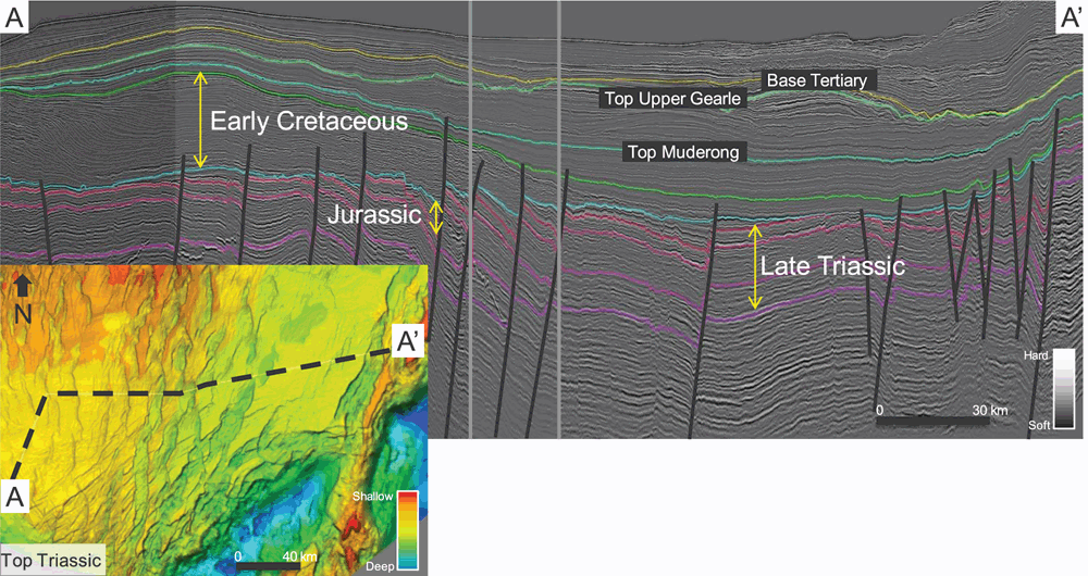
The Northern Carnarvon Basin (NCB) along the NW margin of Australia covers a vast area of approximately 535 000 km2 and represents Australia’s leading hydrocarbon province. The majority of Chevron interests fall within the Exmouth Plateau, Barrow sub-basin and along the Alpha Arch and Rankin Platform. This area is blanketed by a patchwork of 3D seismic surveys of various vintages, processing types and data sources presenting a significant challenge for regional exploration studies. Chevron’s main exploration targets occur in the 4+ km-thick succession of alluvial to shallow-marine deposits of the Late Triassic Mungaroo and Brigadier Formations and the overlying Early Jurassic North Rankin Formation. This interval is characterised by relatively isopachous strata that was later deformed during Jurassic and early Cretaceous rifting events (Fig. 1).
The vast geographical scale and the diversity of available seismic data led the Chevron Australian Business Unit (ABU), to investigate ways to merge imaging results from adjoining seismic surveys in the Mungaroo Formation with the goal of providing an un-interrupted view across the basin. A regional amplitude calibration methodology was developed to account for amplitude imbalances between surveys allowing relative amplitude differences to be preserved. This work evolved into the development of the Regional Stratal Slice Volumes (RSSVs) technology currently deployed in the Chevron ABU. The primary goals of the RSSV project were to identify new exploration opportunities and provide a way to de-risk reservoir, trap and seal presence.
Improved regional understanding of the distribution of sequence boundaries, regional marine flooding surfaces and transgressive events through detailed biostratigraphic analysis (e.g. Payenberg et al. 2013; Marshall and Lang 2013) improved regional seismic correlations and provide a robust framework for regional stratigraphic imaging in the Mungaroo. Five regionally extensive seismic surfaces (maximum flooding and transgressive surfaces) within the Mungaroo were systematically mapped within this framework across the basin and were subsequently used in stratal flattening.
Methodology and results
Due to the relatively isopachous nature of the Triassic Mungaroo/Brigadier Formations, supported by multiple regional flooding events, proportional flattening was the preferred method for constructing the Mungaroo RSSV. The main Jurassic break-up unconformity eroded many horst blocks where exploration potential exists. To flatten data where the regional horizons have been eroded, a systematic re-construction process was employed.
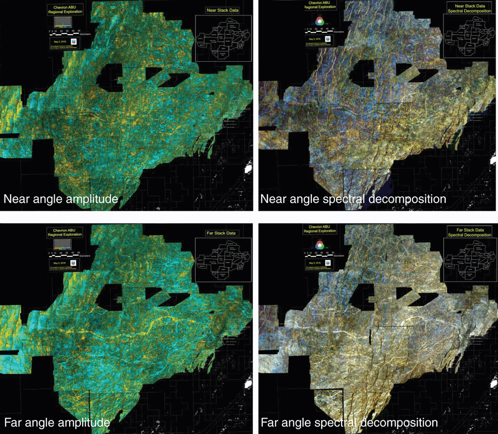
A set of attributes from near and far angle-offset stacks were computed for individual surveys and combined into a merged regional mosaic forming an RSSV. As part of this process a proprietary survey alignment methodology was used to align stratal slices between surveys to ensure synchronisation of stratigraphic imaging between surveys. RSSV attributes were selected based on several criteria. Optical stacking of near and far amplitude data were selected to mitigate the ‘porpoising’ effect encountered as the stratal slice departs from datum surface control. These displays also aided in evaluation of polarity reversal and AVO class identification. Spectral decomposition which incorporates a thicker vertical window was selected as it improves channel belt continuity, enhances shoreline identification and aids in environment of deposition (EOD) interpretation (Fig. 2).
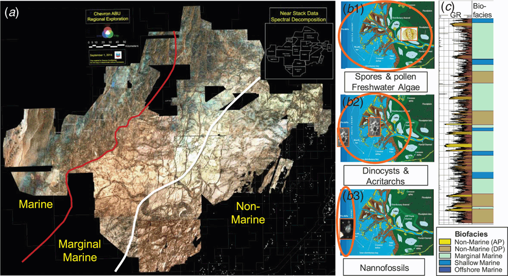
Paleo-environments, interpreted through the integration of biofacies (such as marine fauna and plankton associations, terrestrial versus marine palynomorph assemblages, freshwater algae, composition and preservation of organic matter and the grain size of organic particles) and RSSV-based seismic stratigraphy enabled confident interpretation of shoreline and marginal marine to non-marine boundaries over a 30-million-year time period throughout the Triassic Mungaroo. These boundaries were used to produce regional scale EOD maps showing marine, marginal marine and non-marine depofacies belts (Fig. 3). Stacking of the EOD maps highlighted how these facies belts have shifted laterally through time. The temporally-systematic fluctuations of the Mungaroo shoreline observed in the RSSVs, combined with similar trends observed in the biofacies, have clarified ABU’s understanding of the sequence stratigraphic significance of well-based regional stratigraphic framework picks. This new framework provided a predictive stratigraphic context for the basin, which can be applied to not only the shallow, well-imaged portion of the basin, but also to the deeper, less well-imaged portion of the basin. Within this framework, maximum regressions (sequence boundaries) tended to be associated with wider, thicker, more proximal deposits within Chevron’s acreage, while maximum transgressions (maximum flooding events) were associated with less-wide, thinner and more distal deposits.
Progradational and retrogradational trends in the shoreline position, when combined with distinct basinward and landward shifts in biofacies, have greatly increased Chevron’s understanding of the stratigraphic evolution of the area. Shoreline regressions were characterised by periods of active delta-building with broad, well-developed marginal marine zones. During periods of active transgression, the marginal marine zone is often cannibalised by the quickly advancing shoreline, which juxtaposes non-marine and marine zones, possibly allowing for the deposition of fluvial sands directly into a marine environment.
RSSV attribute volumes were combined with automatically generated closures integrating stratigraphy with structure/trap presence and provided a platform to screen for prospectivity. Knowledge gained from improved stratigraphic and depositional environment interpretations provided valuable information for play fairway identification, lead and prospect evaluation and reservoir modelling inputs.
Summary and conclusion
The use of RSSVs has provided a step change in understanding the Mungaroo Formation of the NCB, an area comparable in size to the Gulf of Mexico. RSSVs have enabled the visualisation of detailed geomorphological information across a large region of the NCB, which in turn provides insight into reservoir and seal distribution, understanding of regional changes in AVO behaviour and understanding of chronostratigraphic/lithostratigraphic relationships throughout the Mungaroo section without having to map a significant number of horizons. RSSVs have enabled the rapid screening of the 4+ km thick Mungaroo Formation for prospectivity and the population of robust channel dimension data bases. It has also provided stratigraphic information to populate static reservoir models, and assisted in analog selection for volumetric inputs in prospect reviews. The RSSVs, in conjunction with biostratigraphy, have led to play and sand fairway prediction, seal and reservoir risk assessment, and a better understanding of how the quality of these units are related to EODs.
Conflicts of interest
The authors declare no conflicts of interest.
Acknowledgements
The authors would like to thank Chevron management for the opportunity to present this paper and to Schlumberger, TGS and Spectrum for use of seismic data.
References
Marshall, N., and Lang, S. (2013). A new sequence stratigraphic framework for the North-West Shelf, Australia. In ‘The Sedimentary Basins of Western Australia IV: Proceedings of the Petroleum Exploration Society of Australia Symposium, Perth, WA, 2013.’ (Eds M. Keep and S.J. Moss).Payenberg, T., Howe, H., Marsh, T., Sixsmith, P., Kowalik, W., Powell, A., Ratcliffe, K., Iasky, I., Allgoewer, A., Howe, R., Montgomery, P., Vonk, A., and Croft, M. (2013). An integrated regional Triassic stratigraphic framework for the Carnarvon Basin, NWS, Australia. In ‘The Sedimentary Basins of Western Australia IV: Proceedings of the Petroleum Exploration Society of Australia Symposium, Perth, WA, 2013.’ (Eds M. Keep and S.J. Moss).

Tony Marsh holds a B.Sc. and M.Sc. degrees in geology from the University of Texas at San Antonio. He has worked in the oil and gas industry for 24 years, 15 years with Paradigm Geophysical and the past 9 years with Chevron’s Australian Business Unit in Perth, Australia. While at Paradigm, Tony held various positions including product management of Paradigm’s visualisation and interpretation portfolio, regional geophysicist in Asia Pacific region and technical director, USA. At Chevron, Tony has worked on various basin-scale exploration projects within the regional exploration team focusing on stratigraphic imaging. He is a member of PESA and SEG. |

Bill Kowalik holds degrees in geology from the University of Pittsburgh (B.Sc.), Pennsylvania State University (M.Sc.) and Stanford University (Ph.D.). He retired in 2017 from Chevron as an Earth Science Consultant after 35 years, the last 8 years in Perth. At Chevron, Bill participated in the development, deployment and application of various technologies, including exploration by remote sensing and the enhancement, creative display and interpretation of seismic data. He currently works as an earth science consultant from Bend, OR, USA. He is a member of SEG, AAPG, EAGE and GSA. |

Rhonda Welch holds B.S. and M.S. degrees in Geological Sciences from Virginia Tech and a Ph.D. in Geology from James Cook University. She has 17 years of experience with Chevron specialising in regional-scale geology, clastic stratigraphy and stratigraphic visualisation techniques. Her work has focused on multiple basins from around the world. She currently leads the Seismic Stratigraphy Interpretation Team within Chevron’s Energy Technology Company and is a member of AAPG and the Houston Geological Society. |

Anne Powell completed a B.Sc. (Hons.) degree at the University of Melbourne in 2002 and has worked in the oil and gas industry for 14 years. Her honours project focused on velocity controls within Cenozoic carbonates of the Dampier Sub-basin. From 2003 to 2004, she worked for the DPI Basin Studies Group, then worked as a Melbourne based exploration geologist (2004–2010). For the past 7 years, she has worked as an Exploration Geologist on the Chevron ABU Regional Exploration Team with a focus on stratigraphy. She is a member of AAPG and PESA. |

Heidi Howe completed a B.Sc. (Hons.) degree in Geology from the University of Western Australia where she researched Late Triassic palynostratigraphy as part of her honours thesis and then went on to research Albian/Aptian dinocysts from the Southern Carnarvon Basin. Heidi joined Chevron in 2006 as a biostratigrapher working in the Global Technology Company in Houston and later in Perth. Heidi is currently an independent biostratigraphy consultant. She is a member of AASP and GSA. |

Bill Hallager completed a B.A. degree in Geology from Dartmouth College, USA and a Ph.D. from University of California Berkeley. Bill worked for Anaconda and Homestake Mining Companies before joining Chevron in 1982. Bill started work at Chevron at the Chevron La Habra upstream research laboratory, then worked in international exploration and development roles in Nigeria, Kazakhstan, Canada, California and Australia. Bill retired from Chevron in December 2017 from a role as Manager of Regional Exploration for Chevron’s Australia Business Unit. Bill is a member of AAPG and PESA. |


