Browse to Bonaparte stratigraphic evaluation
Marcus Lemberger A , James Stockley A and Tim Gibbons ATGS.
The APPEA Journal 53(2) 483-483 https://doi.org/10.1071/AJ12094
Published: 2013
Abstract
After an initial 2010 stratigraphic, depositional environment and facies determination study of 75 wells in the Browse Basin, TGS has pushed this high-resolution project north into the Bonaparte Basin area. The study incorporates a further 165 wells located across the Ashmore Platform, Vulcan Sub-basin, Londonderry High, Malita and Calder Grabens, Sahul and Flamingo synclines, Laminara and Flamingo highs, Sahul Platform, Troubadour Terrace, and offshore Petrel Sub-basin areas.
This multi-basin project has combined all the selected relevant public data into one interpretation study and is delivered in an integrated environment—wells are standardised and sequences interpreted. Once depositional environment and facies are allocated, multi-element maps are produced showing how the basin environments change through time and structural evolution. Stratigraphic interpretation has determined 37 sequences and 32 associated facies maps.
Both Browse Basin (140,000 km2) and Bonaparte Basin (270,000 km2) are relatively less explored and at different ages in their exploration life-cycle. Both have proved to be oil and gas bearing across numerous different stratigraphic ages with a wide range of trapping and reservoir methods. This study aims to further aid North West Shelf exploration by delineating, among other facets, the presence or otherwise of rocks with reservoir and seal potential and by identifying structural elements such as the Petrel Sub-basin salt diapirs.
This regional well data stratigraphic approach has been used across all the UK and Norway continental shelf hydrocarbon provinces. TGS sees the Australian North West Shelf as a province where this approach will further assist sub-surface understanding, and hence exploration success.
Introduction
After an initial study of the stratigraphy, depositional environments, and facies in 2010 in the Browse Basin, TGS has extended this high resolution project north into the Bonaparte Basin area to produce one consistent interpretation across these two proven hydrocarbon provinces on the North West Shelf. Well data from 238 key wells along with a 2D seismic data set were interpreted, from which 37 sequences were delineated to model basin history and produce detailed facies maps.
By mapping interpreted source, reservoir, and seal sequences, this study aims to establish a consistent model for the depositional fill of both basins and, subsequently, propose similar environments in under-explored areas. The data rich study includes all edited well log data, sequence, lithostratigraphic, and chronostratigraphic interpretations coupled to depositional environments and facies with subsequent basin wide maps, thus aiding a regional to sequence understanding. This study is delivered through the TGS facies map browser (FMB) software.
The Browse Basin (185,000 km2) is a northwest-trending sedimentary basin with preserved Palaeozoic to Tertiary depocenters. It is bounded to the southeast by the Kimberley block, to the southwest by the adjoining Roebuck Basin; the western limits reach the Scott Plateau. The basin is separated from the greater Bonaparte Basin by the Londonderry High and Ashmore Platform to the north. The Bonaparte Basin (270,000 km2) has a more complex structural configuration with a series of Paleozoic-Mesozoic Highs and Mesozoic-Tertiary depocentres. It is bounded by the onshore Petrel Sub-basin to the south, the Timor subduction zone to the north and the Money Shoal Basin to the East.
Eight phases of basin development were identified:
-
Late Devonian to Early Carboniferous extension in the Petrel Sub-basin
-
Late Carboniferous to Early Permian extension initiating northwest-trending proto-basins
-
Late Permian to mid-Triassic thermal subsidence and formation of a sag basin
-
Late Triassic to Early Jurassic inversion associated with the Fitzroy movement
-
Early Jurassic pre-rift extension collapsing the inversion structures
-
Middle Jurassic to Early Cretaceous rift related extension and associated graben development
-
Early Cretaceous to early Tertiary thermal subsidence and Passive Margin development
-
Middle to Late Miocene inversion
Tied to an extensive 2D regional seismic data grid, the study of 238 wells represents a well density figure of 0.58 wells/1,000 km2 (one well/1,720 km2). These show both basins are still significantly under-explored with extensive scope for stratigraphic trap exploration after drilling the major anticlinal features, for example the Poseidon/Kronos, Prelude and Concerto discoveries.
The stratigraphic interpretation was modified from the established BBHR scheme by Blevin et al (1997). The 26 sequences originally interpreted have been increased to 37 in this study to reflect varying depositional histories observed in wells within the Bonaparte Basin. The BB sequences range from BB1A Devono-Carboniferous through to BB21 in the Late Miocene.
Depositional history
With constraints from varying well penetrations the major depositional events are summarised as follows:
-
Ordovician to Silurian aged evaporites have been interpreted in the Petrel and, to a lesser extent, Vulcan Sub-basins.
-
Devono-Carboniferous (BB1A-1B): Marine shales, sands and carbonates of the Weaber Group were deposited on a shelfal setting in the Petrel Sub-basin.
-
Carboniferous-Permian (BB2A-BB3C): Includes the fluvio-deltaic and shallow marine sands and shales of the Kulshill Group. Glacio-marine shales and sands associated with Gondwanan glaciation in the Petrel Sub-basin. Upper Permian Kinmore Group mixed clastic carbonate on a broad shelf (Cape Hay and Tern Formations).
-
Triassic (BB4A,B,C - BB5A): Shallow marine and fluvial/alluvial clastic sedimentation of the Sahul Group. These channel dominated facies become increasingly marine influenced to the northwest, with shallow marine carbonates are present to the western edges of the study area.
-
Jurassic (BB5B-BB7): Plover Formation, fluvial-alluvial and shallow marine facies in-filled collapsed inversion structures. Proven gas reservoirs in this interval include the Torosa, Brecknock, Calliance, Ichthys, Bayu/Undan, Sunrise and Evans Shoal discoveries.
-
Late Jurassic (BB8A,B,C): Following Callovian uplift, several rift-related extension events led to structural compartmentalisation and the deposition of marine fan sands and thick pelagic muds of the Swan/Flamingo Groups in the grabens.
-
Cretaceous (BB9): Berriasian to Mid-Valanginian Brewster Member sands (Ichthys Field) and Sandpiper Sandstone Member sands (Petrel Sub-basin) muds were deposited in a restricted marine environment.
-
Cretaceous (BB10-BB11): Neocomian Bathurst Island Group/Echuca Shoals Formation muds represent a low energy clastic source and seal. These were deposited during an overall transgressive cycle bringing an end to the rifting phase.
-
Cretaceous (BB12): Progressing from a restricted to fully open marine environment, the basins developed thick, prograding shelf/slope mudstones of the Jamieson Formation. The Formation has seal potential and is associated with important distal outer shelf turbidites.
-
Cretaceous (BB13-BB15): Santonian (BB13) deposition includes the deep marine pelagic marls/carbonates cycles of the Woolaston-Fenelon-Gibson Formations, Campanian/Maastrichtian (BB14/BB15) lowstand Puffin Formation sand fans and the overlying Prudhoe fluvio-deltaic facies. In the outer reaches of both the study area carbonates still dominate.
-
Tertiary (BB16-BB21): A thick shallow water carbonate ramp developed in the Paleocene-Eocene. By the Late Oligocene (BB19), deposition was limited to the outboard areas. In the Mid-Miocene a broad carbonate shelf established, along with a proximal coastal deltaic system.
The Browse to Bonaparte Basin FMB
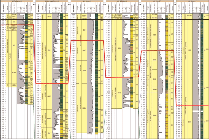
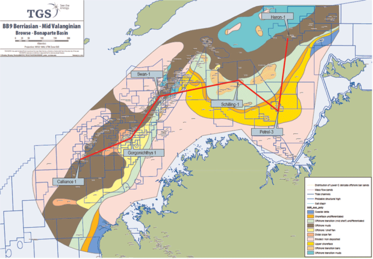
This Fig. 1 shows an northeast–southwest example well correlation from the FMB, hung on the top of BB9 (black) and highlighting the Early Cretaceous Berriasian-Mid Valanginian Upper Swan and Flamingo Groups. Brewster Member, high energy axial mass flow sands, deposited on a clastic shelf are present in Gorgonichthys-1, these thin to deeper, lower energy pelagic muds in Calliance-1. Cyclical inner shelf bar sands are interpreted in the Petrel Sub-basin (Petrel-3, Schilling-1), which progress to thick marine shales in what were the rapidly subsiding Malita and Vulcan grabens to the north and west.

|
The TGS Facies Map Browser aims to be the unique tool for exploration across the North West Shelf hydrocarbon provinces. The FMB has the advantage of regular updates with newly released wells and stratigraphic concepts. The FMB concept is designed to provide a robust geological model upon which the exploration geoscientist can base hydrocarbon play concepts.
Depositional environment and facies
The depositional environments and facies within the FMB are interpreted once sequence stratigraphy has been interpreted. These environment and facies maps are based on well and seismic interpretations and tied to available biostratigraphy.
References
Blevin, J.E., Struckmeyer, H.I.M., Boreham, C.J., Cathro, D.L., Sayers, J., and Totterdell, J.M., 1997—Browse Basin high resolution study. Interpretation report, North West Shelf, Australia. AGSO Record 1997/38.Blevin, J.E., Struckmeyer, H.I.M., Cathro, D.L., Totterdell, J.M., Boreham, C.J., Romine, K.K., Loutit, T.S., and Sayers, J., 1998—Tectonostratigraphic framework and petroleum systems of the Browse Basin, North West Shelf. IN: Purcell, P.G., and Purcell, R.R. (eds) The sedimentary basins of Western Australia 2. Proceedings of the Petroleum Exploration Society of Australia Symposium, Perth, 1998, 369–95.
Gorter, J.D., 1998—Revised Upper Permian stratigraphy of the Bonaparte Basin. In: Purcell, P.G., and Purcell, R.R. (eds), The Sedimentary Basins of Western Australia 2. Proceedings of the Petroleum Exploration Society of Australia Symposium, Perth, 1998, 213–28.
Gorter, J.D., Jones, P.J., Nicoll, R.S., and Golding, C.J. (2005). A reappraisal of the Carboniferous stratigraphy and the petroleum potential of the southeastern Bonaparte Basin (Petrel Sub-basin), North Western Australia. The APPEA Journal 45, 275–96.
Gorter, J.D., Poynter, S.E., Bayford, S.W., and Caudillo, A. (2008). Glacially influenced petroleum plays in the Kulshill Group (Late Carboniferous Early Permian) of the southeastern Bonaparte Basin, Western Australia. The APPEA Journal 48, 69–113.
Longley, I.M., Buessenschuett, C., Clydsdale, L., Cubitt, C.J., Davis, R.C., Johnson, M.K., Marshall, N.M., Murray, A.P., Somerville, R., Spry, T.B., and Thompson, N.B., 2002—The North West Shelf of Australia—a Woodside perspective. In: M. Keep and S. Moss (eds) The Sedimentary Basins of Western Australia. Proceedings Western Australian Basins Symposium 3, Perth, 28–88.
Maung, T.U., Cadman, S., and West, B., 1994—A review of the petroleum potential of the Browse Basin. In: Purcell, P.G., and Purcell, R.R. (eds) The Sedimentary Basins of Western Australia. Proceedings of the Petroleum Exploration Society of Australia Symposium, Perth, 1994, 333–46.
Mory, A.J., 1991—Geology of the Offshore Bonaparte Basin, North Western Australia. Report 29. Perth, Western Australia: Geological Survey of Western Australia, Department of Mines Western Australia.
Robinson, P., and Mcinerney, K., 2004—Permo-Triassic Reservoir Fairways of the Petrel Sub-Basin, Timor Sea. In: Ellis, G.K., Baillie, P.W., and Munson, T.J. (eds) Timor Sea Petroleum Geoscience. Proceedings of the Timor Sea Symposium, Darwin, 19–20 June. Northern Territory Geological Survey, Special Publication 1, 295–312.

After graduating from Imperial College, London, Marcus has been working as a geologist at TGS for five years. He has mainly worked on mult–client sequence stratigraphic studies, and he has a range of experience from offshore North West Europe to Brazil and now in Australia. |

James Stockley is a geologist with 33 years’ upstream and midstream oil & gas experience. After graduating in 1975 from Imperial College, London, with an MSc (petroleum geology), he worked for 13 years in many countries with Chevron, including two years in research at La Habra, California. He subsequently spent seven years employed by Oryx UK Energy as a geologist, geological supervisor, and team Leader. For the past 10 years, he was exploration manager for CIECO UK, a subsidiary of the Japanese trading house, Itochu. He has gained wide experience in North Africa, the Middle East, the Americas, and northwest Europe working in exploration through to production plus A&D, including six years in export distribution at the Brent System/Sullom Voe Terminal in the Shetland Isles. In 2001 he obtained an MBA from Henley Management College. |

An experienced account manager and sales manager with a track record of growth, both in revenue and client numbers through business development and marketing activities. I have managed a variety of teams during this time and developed a great team ethos and job satisfaction amongst the people who have worked for me. I have very good interpersonal skills and an ability to get on with people. Client satisfaction is always very important to me and I work hard to ensure that this is achieved. |


