

Factors enabling fire management outcomes in Indigenous Savanna fire management projects in Western Australia
Tom Vigilante A B C I * , Balanggarra Aboriginal Corporation E , Dambimangari Aboriginal Corporation F , Wilinggin Aboriginal Corporation G , Wunambal Gaambera Aboriginal Corporation A , Catherine Goonack A , Desmond Williams A , Aidan Joseph D , Leigh-Ann Woolley H I and Rohan Fisher DA
B
C
D
E
F
G
H
I
Abstract
Balanggarra, Dambimangari, Wilinggin and Wunambal Gaambera Traditional Owners in Western Australia operate Savanna Fire Management projects under the collective North Kimberley Fire Abatement Project.
We examine changes to the fire regime before and after the initiation of these projects and discuss implications for incentivising savanna fire management.
Using established methods and high-resolution imagery, we compared fire metrics between baseline (2001–2011) and project years (2012–2022).
Fire seasonality notably shifted from late to early dry season dominance with fewer late season fires across, resulting in carbon abatement. While total area burnt remained similar, annual fire pattern transitioned from a cyclical to less variable regime. Fire patchiness, fire age diversity, and area of long unburnt vegetation increased while fire frequency decreased. A minimum of 4 years of fire management was required before significant changes in fire metrics were observed.
The fire regime on Traditional Owner lands has improved significantly, enabled by the emergence of land and sea management, carbon markets, support of partner agencies, and the securing of land rights.
Beyond carbon credits, access to technology holds promise for sustained improvements to adaptive fire management built on strong foundations of traditional burning practices.
Keywords: Aboriginal fire management, Carbon Abatement, Savanna Fire Management.
Introduction
Traditional Owners (Indigenous people) in the north Kimberley region of Western Australia have an enduring culture of landscape burning that has survived significant stresses during the colonial and post-colonial periods (Crawford 2002; Jebb 2002; Vigilante 2004; Vigilante et al. 2004, 2009). Over the past few decades Traditional Owners (Aboriginal people with the right to occupy specified lands and waters) have established land management programs to apply fire across the full extent of their lands. As part of this transition in the Kimberley region of Western Australia, the Balanggarra, Dambimagari, Wilinggin and Wunambal Gaambera Traditional Owners operate large Savanna Burning carbon projects under an affiliation called the North Kimberley Fire Abatement Project (NKFA Project).
North Kimberley Traditional Owners have articulated their cultural practice of landscape burning and their land management goals in their Healthy Country Plans (Balanggarra Aboriginal Corporation 2011; Wunambal Gaambera Aboriginal Corporation 2010, 2021; Dambimangari Aboriginal Corporation 2012, 2023; Wilinggin Aboriginal Corporation 2012, 2023; Balanggarra Aboriginal Corporation, Kimberley Land Council 2024), which are developed using a local form of the Open Standards for the Practice of Conservation (Moorcroft et al. 2012; Conservation Standards 2024). These Traditional Owner groups have also established Indigenous Protected Areas and Indigenous Ranger teams since securing greater recognition, control, enjoyment and/or ownership of lands and seas through native title (legal recognition of Indigenous land rights under Australian law through the Native Title Act of 1993 (Federal Register of Legislation 2024a)) and other means.
The Savanna Fire Management Methodology (hereafter SFM Methodology) also known as Savanna Burning (Federal Register of Legislation 2024b) operates under the Australian Government’s Australian Carbon Credit Unit Scheme (Clean Energy Regulator 2024a) based on the publication of the methodology in 2013 (Russell-Smith et al. 2009; Federal Register of Legislation 2024c) and its initial application as a voluntary scheme under the Western Arnhem Land Fire Abatement Project (Ansell et al. 2020). The SFM Methodology enables a project to avoid the emission of methane (CH4) and nitrous oxide (N2O) through the use of strategic early dry season fire management across the savannas of Australia. The methodology involves comparing the early dry season and late dry season fire emissions against a 10-year pre-management baseline average. North Kimberley Traditional Owner groups were directly involved in the establishment of the methodology through long-running partnerships with lead agencies and other Indigenous groups across the savanna region and have adopted the methodology to support the development of their fire management programs.
Until recently, the contemporary fire regime of the north Kimberley, as for much of northern Australia’s vast tropical savanna, was dominated by unmanaged severe and large late dry season (LDS, August to December) wildfires (Fisher et al. 2003; Russell-Smith et al. 2003). This regime emerged in the mid-1900s during the early post-colonial era due to the decline of traditional Aboriginal landscape burning across large areas and continued into recent decades in the absence of effective alternative management (Vigilante et al. 2004). These wildfires have been largely detrimental to biodiversity and other natural and cultural values (e.g. Radford et al. 2020; Wunambal Gaambera Aboriginal Corporation 2021). This wildfire regime typically involved a cyclical ‘boom-bust’ cycle of large wildfires 1 year followed by much less fire the next (Russell-Smith et al. 2003). In the early 2000s, fire management programs emerged in the northern savannas of Australia focused on reducing the influence of more severe late dry season wildfires through the application of prescribed fires in the early dry season (EDS, April to July), later adopting the SFM Methodology (Legge et al. 2011; Ansell et al. 2020; Radford et al. 2020). Recent studies have shown that these programs have been largely successful in reducing the influence of wildfires on fire regimes, balanced by an increase in early dry season management fires (Evans and Russell-Smith 2019; Radford et al. 2020; Edwards et al. 2021).
A few studies have examined the outcomes of Savanna Fire Management across northern Australia, comparing pre-management years and project years across large projects and regions (including across high and low rainfall zones) with some consistent results (Evans and Russell-Smith 2019; Radford et al. 2020; Edwards et al. 2021). All studies found that the application of management fires in the EDS period has resulted in increases in annual area burnt by EDS fire, and in some cases, increases in the number of small EDS fires (e.g. Evans and Russell-Smith 2019). All found that the management approach has successfully reduced the influence of LDS fires on fire regimes, with a reduction in the annual area of LDS fire and in one project, a reduction in the size and number of LDS fires (Evans and Russell-Smith 2019). Fire season is used as a proxy for fire intensity, with greater likelihood of high intensity fires later in the season when fuels have accumulated and cured in the absence of rain (Russell-Smith and Edwards 2006). In Australian savannas, 90% of rain falls during the wet season between December and April (Bureau of Meteorology 2024a). Breaking the cycle of frequent annual or biennial extensive, high intensity wildfires has been a key objective of Savanna Burning. While projects have consistently achieved this outcome, no project has been able to achieve a significant change in the total annual area burnt (Corey et al. 2020; Radford et al. 2020); however, reductions in inter-annual variability of area burnt have occurred (Evans and Russell-Smith 2019; Radford et al. 2020).
Furthermore, improvements in other fire metrics have proven difficult to consistently achieve. Edwards et al. (2021) reported a modest increase in the area of unburnt habitat that was more than 2 years unburnt but not a significant increase in older fuel ages (i.e. more than 5 years unburnt), while Radford et al. (2020) reported a 28% increase in the number of patches more than 4 years unburnt. Evans and Russell-Smith (2019) reported a decrease in the average distance to unburnt patches. Many wildlife ecologists have argued that a diversity of fuel ages is beneficial to support biodiversity, and areas of longer unburnt that are of particular value as they provide extra cover for animals evading predation (Radford et al. 2015; Leahy et al. 2016; Radford et al. 2020; Einoder et al. 2023). There is some evidence that fire frequency is reduced by the SFM Methodology with Edwards et al. 2021 and Radford et al. 2020 reporting a halving in fire frequency (cf. Evans and Russell-Smith (2019) who reported no change). Evans and Russell-Smith (2019) was the first of these studies to utilise high resolution, fine scale burnt area mapping data based on LANDSAT and Sentinel 2 satellite imagery, (cf. MODIS, Moderate Resolution Imaging Spectroradiometer satellite (NASA 2024) used by other studies). This improvement in burnt area mapping accuracy influenced results obtained, particularly regarding fire patchiness (Edwards and Russell-Smith 2009; Edwards et al. 2018).
In this study, we assess the fire management outcomes of large long-running indigenous fire projects in Western Australian savannas operating under the North Kimberley Fire Abatement (NKFA) Project by assembling and analysing a new fine scale burnt area mapping dataset derived from satellite imagery. As far as the authors are aware, this dataset is the most extensive spatial and temporal burnt area product, produced using medium-resolution Landsat and Sentinel-2 data, ever presented in a published study. A range of fire metrics are analysed to test the effectiveness of indigenous fire projects in mitigating wildfires and reducing other damaging elements of prevailing fire regimes in northern Australia identified in Healthy Country Plans. We reflect on and discuss the various factors that have enabled and contributed to these observed changes as well as the various challenges and limitations projects have faced.
Materials and methods
Study area
The remote north Kimberley in the north of Western Australia covers over 140,000 km2, an area more than twice the size of Tasmania. It is largely inaccessible and the main public access, the Gibb River Road, is unsealed.
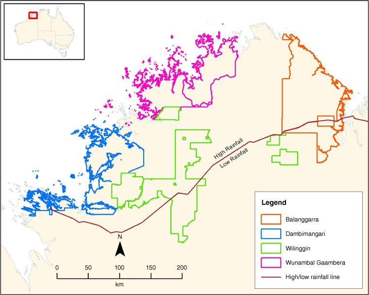
The North Kimberley Fire Abatement (NKFA) Project was established in 2008 to support four Indigenous native title groups to establish fire projects under the carbon methodology being developed at the time. Each group was responsible for establishing and operating their own fire project but worked together under the NKFA Project to share resources and approaches. The four projects and their associated native title areas (National Native Title Tribunal 2024) are described below and in Fig. 1.
The Balanggarra Fire Project operated by the Balanggarra Aboriginal Corporation RNTBC; >1,113,767 ha associated with the Balanggarra Combined Native Title Determination areas (Cheinmora v State of Western Australia 2013);
The Dambimangari Fire Project operated by the Dambimangari Aboriginal Corporation for the Wanjina Wunggurr (Native Title) Aboriginal Corporation RNTBC (WWAC); >805,799 ha associated with the Wanjina Wunggurr Dambimangari Native Title Determination (VB (Deceased) v State of Western Australia 2011);
The Wilinggin Fire Project is operated by the Wilinggin Aboriginal Corporation for the WWAC; >1,072,724 ha under the Wanjina Wunggurr Native Title Determinations. (Neowarra v FCA 2004); and
The Wunambal Gaambera Uunguu Fire Project is operated by Wunambal Gaambera Aboriginal Corporation for the WWAC; >843,925 ha associated with the Wanjina Wunggurr Uunguu Native Title Determinations (Goonack v FCA 2011; Puermora v FCA 2012).
The North Kimberley Fire Abatement Project comprised four fire projects associated with Balanggarra, Dambimangari, Wilinggin and Wunambal Gaambera Aboriginal Corporations. A red line separates high rainfall (>1000 mm) and low rainfall (600–1000 mm) zones.
The project area is of high conservation value, including a National Biodiversity Hotspot (McKenzie and Burbidge 2002) and the West Kimberley National Heritage listing (Department of Climate Change, Energy and Environment and Water 2024a). Each north Kimberley group has developed a Healthy Country Plan to manage land and culture and have dedicated Indigenous Protected Areas (Department of Climate Change, Energy and Environment and Water 2024b) and established indigenous ranger teams (Department of Climate Change, Energy and Environment and Water 2024c).
Each project undertakes their own fire operations together with operational partners. Traditional Owners attend an annual fire planning workshop and take part in fire operations in different roles. A significant amount of burning is undertaken from a rotary or fixed-wing aircraft using an aerial incendiary machine that is the only practical means of applying fire across large, rugged and inaccessible areas. Traditional Owners typically participate as navigators or incendiary machine operators. Other burning is implemented on foot or from vehicles.
There are two broad approaches used to apply aerial burning. The strategic fire lines approach developed in the Northern Territory and Kakadu National Park (Petty et al. 2007) uses aerial burning to create strategic fire breaks in the landscape and draws on some cultural Aboriginal burning concepts (Price et al. 2007; Russell-Smith et al. 2013). The systematic ignition approach was developed by government in the south-west of Western Australia and adapted to the northern Australian context (Burrows & McCaw 2013; Burrows et al. 2021). It involves flying in a grid pattern to achieve required prescriptions based on fuel type and age. Most groups have adopted the strategic fire line approach but have also used systematic ignition at some stages. Both approaches have been subject to some criticism (Corey et al. 2020; Edwards et al. 2021).
The vegetation of the region is characterised as predominantly open savanna woodland with tallgrass (Beard 1979); however, it has been further classified into four fuel structural types under the Savanna Burning methodology: ‘Shrubland with hummock grasses’; ‘Woodland with hummock grasses’; ‘Woodland with mixed grasses’; and ‘Open forest with mixed grasses’ as outlined in Tables G and H of the legislation (Federal Register of Legislation 2024b).
The region has a tropical monsoonal climate with most rain falling between November and April when there is an associated high incidence of lightning due to thunderstorms (Bureau of Meteorology 2024a). Average annual rainfall ranges between 1400 mm in the northern-most coastal areas to approximately 700 mm in the southern-most areas of Wilinggin Country (Fig. 1). The SFM Methodology accounts for two rainfall zones, the High Rainfall zone (>1000 mm) and the Low Rainfall zone (600–1000 mm). Geologically, the study area consists of gently undulating but rugged sandstone, as well as volcanic and laterite hills and plateaus (Beard 1979).
Burnt area mapping
Landsat-based burnt area mapping has been a commonly used method for fire regime assessment across the savannas of northern Australia since 1980 (Edwards et al. 2001; Fisher et al. 2003), both for support of burning operations and for ecological monitoring (Edwards, Russell-Smith, et al. 2003b; Price et al. 2005). Details of the image-processing validation of the burnt area products have been documented in several previous studies (Gill et al. 2000; Edwards et al. 2003a; Russell-Smith et al. 2017). For this study, burnt area mapping was produced for 22 years, from 2001 to 2022.
Burnt area mapping was produced using Landsat imagery for years prior to 2016 and primarily Sentinel-2 imagery after 2016. Additional MODIS satellite-derived fire mapping was also used for regions where cloud cover prevented the identification of burnt areas with either Sentinel-2 or Landsat imagery. Google Earth Engine (GEE) cloud-based processing tools were used to produce satellite image mosaics for the north Kimberley study area. For this project, a Middle Infrared Burn Ratio (MIBR) algorithm (Lu et al. 2016) was used to highlight burnt areas. For each year a MIBR mosaic with a 30-m pixel resolution with minimum cloud cover was created for five seasonal periods:
Very early dry (VEDS) season using image dates earlier than April.
Early dry season (EDS) using imagery from April through to the end of May.
Middle dry season (MDS) using imagery from early June to the end of August.
Late dry season (LDS) using imagery from September through to early November.
Very late dry season (VLDS) using imagery from November through December.
Subsequent analysis and processing of the GEE MIBR images were conducted using SAGA GIS raster processing software (Conrad et al. 2015).
To highlight burnt areas between seasonal periods, a difference imaging technique was applied whereby each image mosaic date was subtracted from the prior date to highlight differences between the two periods. The first EDS MIBR image was subtracted from a median MIBR image (produced using GEE), the MDS from the EDS and the LDS from the MDS. Using these MIBR difference data, burnt areas were mapped using an object-based image analysis approach. Once the segmentation for a mapping period was completed, manual editing was conducted to produce a clean burnt area map. To avoid errors of omission hot-spot data, sourced from the North Australian Fire Information (NAFI) website, was used to identify fire events not mapped using the high-resolution imagery. Where the hot-spot data suggested fire events were missed MODIS scale mapping burnt area mapping, sourced via NAFI, was substituted when available to reduce errors of omission. These omission errors where most common very late in the dry season when obscuring cloud cover is common. The higher temporal resolution of the MODIS derived mapping increases the possibility of capturing these significant late season fires (Fisher and Edwards 2015).
Statistical analysis
Fire metrics were derived from burnt area mapping (Table 1). To test whether fire metrics were similar before (2001–2011) and after the fire project began (2012–2022), we used Kruskal–Wallis nonparametric one-way ANOVA. All statistical analyses were run using R ver. 4.3.2 (R Core Team 2023).
| Metric | Metric description | Fire regime measure | |
|---|---|---|---|
| Season Burnt | Proportion burnt in LDS of previous year or proportion burnt in EDS of current year. | Fires that occur in the LDS are generally more severe. The end of July cut-off has long been used as a proxy for LDS fires (Russell-Smith and Edwards 2006). | |
| Fire frequency | Assigns cells in the raster values of 1–22 representing how many times a fire occurred annually in that area over 22 years. | High fire frequencies and short intervals between fires are generally detrimental for savanna fauna and flora (Andersen et al. 2005; Yates et al. 2008). | |
| Time Since Last Burnt (TSLB) | Assigns cells in the raster values of 1–5 representing how many years since last burn, or 6 if the cell last burnt more than 5 years ago. | High fire frequencies and short intervals between fires are generally detrimental for savanna fauna and flora (Andersen et al. 2005; Yates et al. 2008). | |
| Patchiness | Assigns the same unique value to all cells in a continuous patch of burnt or unburnt area. Created by using a region group function, with the burnt/unburnt (BuB) rasters as the base data. | Another important measure of fire and fuel age diversity is the degree of patchiness. The impact of fire on mammal savanna abundance is highly dependent on patchiness of burn, an indicator of fire size and intensity (Lawes et al. 2015; Leahy et al. 2016). | |
| Fire Age Diversity | Assigns cells in the raster values of 1–6 (see TSLB above) representing the number of different fuel ages found within a specific radius around that cell. Created using a focal statistics function, with the TSLB rasters as the base data. Calculated using radius of 1000 m. | Derived from TSLB. Research has shown that a diversity of fuel ages is beneficial to support biodiversity. Of particular value are areas of longer unburnt habitat that provide extra cover for animals evading predation (Radford et al. 2020). | |
| Distance to Unburnt Patch | Assigns cells in the raster a value that represents the distance in metres from the cell to the nearest unburnt patch. Only unburnt patches greater than 10 cells (>9000 m2) were considered. Created using a cost distance function, with the BuB rasters as the base data. | Mean distance to unburnt gives an indication of both the spatial patchiness of fires but also the distances between these patches. Patchy fires reduce the distance that animals need to travel to find shelter in unburnt habitat (Leahy et al. 2016; Einoder et al. 2023). | |
| Long Unburnt (LuB) | Assigns cells in the raster values of 1 for long unburnt areas, or 0 for areas that burnt recently. Long unburnt is classified as having not burnt for 5 or more years. | The retention of long unburnt patches (>4 years unburnt) within fire mosaics benefits savanna mammals in the north Kimberley (Radford et al. 2015) and national parks in the Northern Territory (N.T.) (Einoder et al. 2023). | |
| Long Unburnt Patchiness | Assigns the same unique value to all cells in a continuous patch of long unburnt or recently burnt area. Created by using a region group function, with the LuB rasters as the base data. | The retention of long unburnt patches (>4 years unburnt) within fire mosaics benefits savanna mammals in the north Kimberley (Radford et al. 2015) and national parks in N.T. (Einoder et al. 2023). | |
| Distance to Long Unburnt | Assigns cells in the raster a value that represents the distance in metres from the cell to the nearest long unburnt patch. Only long unburnt patches greater than 10 cells (>9000 m2) were considered. Created using a cost distance function, with the LuB rasters as the base data. | Patchy fires ensure that animals do not have far to travel to unburnt habitat (Leahy et al. 2016; Einoder et al. 2023). Longer unburnt vegetation provides most shelter for fauna (Einoder et al. 2023). |
Results
Area burnt
There was no significant change in mean total area burnt between the baseline and project years (37.5 ± 3.0 [x̅ ± s.e.]% and 33.8 ± 1.8% respectively; χ2 = 0.9, P = 0.34), but there was a significant shift in seasonality of burning (EDS: χ2 = 8.5, P < 0.05, LDS: χ2 = 10.6, P < 0.05; Fig. 2). The fire regime shifted from greatest proportion of area burnt during LDS to a fire regime dominated by EDS fire (Fig. 2, see Supplementary material for annual EDS/LDS mapping).
Proportion (%) of the NKFA Project area burnt during the early dry season and late dry season depicted spatially as LDS (red), EDS (green) and unburnt (grey) for (a) 2007 (before project initiated), and (b) 2015 (after project initiated), and depicted graphically as (c) EDS, LDS and total area burnt before versus after fire project was initiated, and (b) annual area burnt, with year the project began (2012) indicated by a dotted vertical line. Violin plots in (c) give the kernel density estimation, with wider sections representing a greater probability of data points occurring at that value. Box plots depicted within violin plots display the median (thick black line), upper and lower quartiles (box), minimum and maximum values (whiskers) and outliers (black circles).
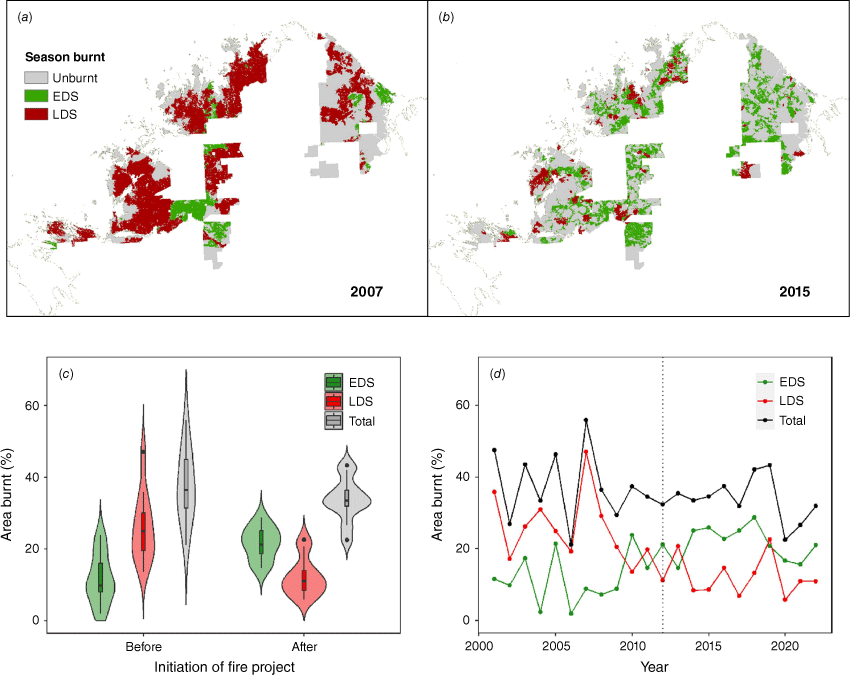
In baseline years (before fire project began), the fire regime was dominated by a cyclical annual wildfire pattern with high variance (Fig. 2c), due to concurrent annual peaks and troughs (Fig. 2d). An average of 42.9 ± 3.9% of total project area was burnt annually in peak years and 29.5 ± 2.4% in trough years. During fire project years, variance in annual total area burnt was reduced and a more stable fire pattern emerged (Fig. 2d). The greatest extent of area burnt was recorded during baseline year 2007 (2,125,376 ha or 55.9% in total), with LDS fires accounting for 47.1% of total area burnt (Fig. 2a, d), related to large wildfire events that affected most projects that year. Most fire occurred between September and November of 2007.
EDS burning averaged 23.4 ± 1.7% of total area burnt between 2012 and 2018 (Fig. 2). It took 3 years after project initiation in 2012 until there was a significant increase between baseline and project EDS extent (χ2 = 4.4, P < 0.05). It took 4 years before LDS extent was significantly lower than baseline (χ2 = 4.3, P < 0.05). After these significant changes in fire regime were established, only 2019 was dominated by LDS fires (22.6% of total area burnt in LDS; Fig. 2d), with most of these fires occurring between October and December. However, when compared with LDS dominated baseline years (mean LDS: 33.5 ± 0.05%), LDS fire extent in 2019 was nevertheless significantly lower than baseline (χ2 = 12.1, P < 0.05).
Fire frequency
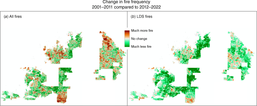
Overall, there was less fire across the project area after initiation of the fire project. Fire frequency decreased across 42.6% (1,611,132 ha) of the fire project area during project years (Fig. 3a). There were less LDS fires across 67.6% (2,556,632 ha) of the fire project area during project years compared with baseline years (Fig. 3b).
Spatial representation of (a) increase (32.6% of project area) and decrease (42.6%) in fire frequency, and (b) increase (11.3%) and decrease (67.6%) in LDS fire frequency across the North Kimberley Fire Abatement Project for project period (2012–2022) compared with baseline period (2001–2011).
Number and size of burn events
Fire patchiness increased significantly from baseline years to project years i.e. total number of patches increased (χ2 = 3.8, P = 0.05), the number of small patches < 500 ha increased (χ2 = 12.4, P < 0.001) and the number of large patches >10,000 ha decreased (χ2 = 11.9, P < 0.001).
Wildfire events >40,000 ha in size occurred during 10 of the 11 baseline years, but only during one of 11 project years. Burnt areas averaged 427 ± 73 ha in size during project years.
Fire age diversity
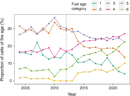
Vegetation fire ages in 1000 m radii around mapped raster cells shifted from predominantly 2- and 3-year-old fuels during baseline years to longer unburnt during the project. One-year-old, 2-year-old and 3-year-old fuel decreased significantly in project years (χ2 = 6.5, 9.0, 8.3 respectively, P < 0.05; Fig. 4). Older aged fuels (≥4 years) increased significantly (χ2 = 9.8, 12.0, and 6.2 for 4-year-old, 5-year-old, and >5 year-old fuels, respectively; P < 0.05, Fig. 4).
Unburnt and long unburnt vegetation
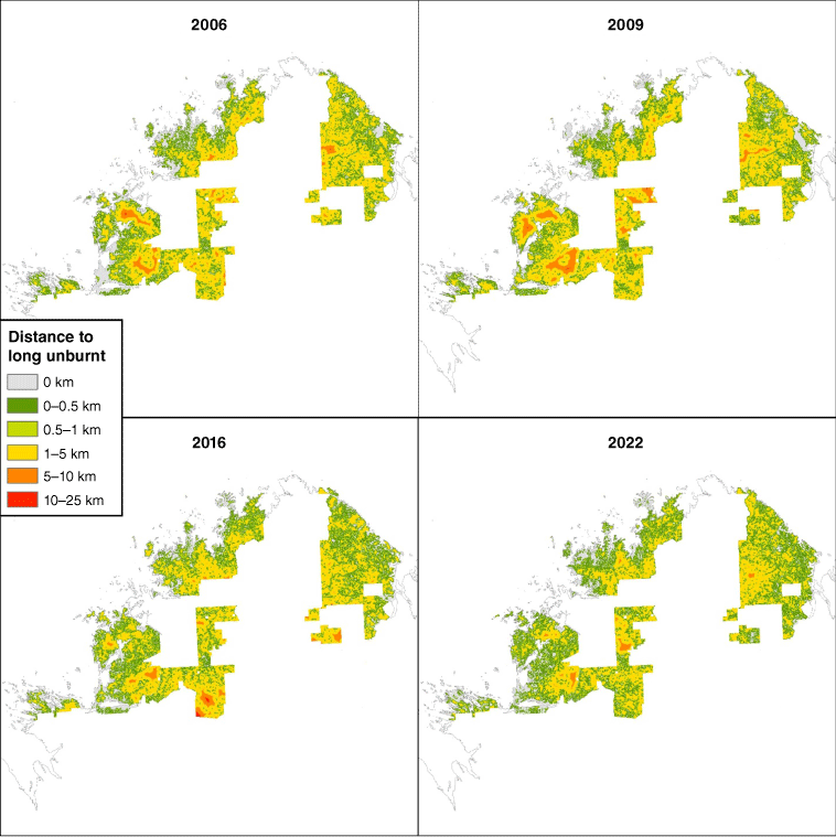
Mean distance to unburnt as well as mean distance to long unburnt vegetation decreased significantly during project years (χ2 = 6.4 and 10.6, respectively; P < 0.05, Fig. 5).
Spatial representation of mean distance to long unburnt vegetation across the NKFA Project for selected baseline years (2004 and 2009), and project years (2016 and 2022).
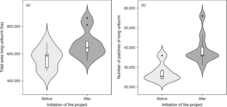
Mean area of unburnt did not differ significantly between baseline (62.5 ± 3.0%) and project years (66.2 ± 1.8%; χ2 = 0.9, P = 0.34). However, total area and number of patches of long unburnt vegetation (>4 years unburnt) increased significantly (χ2 = 4.2 and 8.0, respectively; P < 0.05, Fig. 6).
Increase in long unburnt vegetation (>4 years unburnt) in the NKFA Project before (2001–2011) versus after initiation of the fire project (2012–2022), as (a) proportion of total project area (%) and (b) number of patches. Violin plots are kernel density estimations, with wider sections representing a higher probability of data points occurring at that value. Box plots depicted within violin plots display the median (thick black line), upper and lower quartiles (box), minimum and maximum values (whiskers) and outliers (black circles).
Discussion
Under the leadership of Balanggarra, Dambimangari, Wilinggin and Wunambal Gaambera Traditional Owner groups, the fire regime of the north Kimberley region of Western Australia has improved significantly on Aboriginal-owned land, consistent with the goals set out in the Healthy Country Plans of each of these groups (Balanggarra Aboriginal Corporation 2011; Balanggarra Aboriginal Corporation, Kimberley Land Council 2024; Dambimangari Aboriginal Corporation 2012, 2023; Wilinggin Aboriginal Corporation 2012, 2023; Wunambal Gaambera Aboriginal Corporation 2011, 2021; also Austin et al. 2017). The influence of LDS wildfires has been significantly diminished to the point that it is no longer the defining attribute of the fire regime, as it was in past decades. EDS fires are now a dominant component of the fire regime in the region, with these fires being typically smaller and patchier than LDS wildfires. As a result of this change, fires are now predominantly less severe (‘cooler’), patchier, smaller, and occur less frequently. There is a greater diversity of vegetation fuel ages and more patches of long unburnt vegetation (unburnt for five or more years) contained within the landscape. These changes are considered significant improvements in fire regime, due to frequent, extensive, intense wildfires (that previously dominated the region since European colonisation) being linked to biodiversity decline in northern Australian tropical savannas (Andersen et al. 2005; Yates et al. 2008; Woinarski et al. 2010; Lawes et al. 2015; Radford et al. 2015; Radford et al. 2020) and were also a concern to Traditional Owners as they were a consequence of reduced customary burning as outlined in the Healthy Country Plans of the four Traditional Owner groups involved.
Key improvements under the NKFA Project match those reported for the other SFM Methodology Projects (registered carbon projects using the SFM Methodology) including an increase in the area of EDS fires, a reduction in the annual area of LDS wildfires, a reduction in the size and number of LDS wildfires, a reduction in the inter-annual variability of area burnt, a decrease in mean distance to unburnt and long unburnt patches (Edwards et al. 2021). Additionally, we report a decline in fire frequency, which was not reported in previous studies, as well as an increase in fire-age diversity, particularly older fuel ages, noting that previous work only reported an improvement in >2-year-old fuel ages but not >5-year-old (Edwards et al. 2021).
Enabling factors
A number of factors have contributed to the success of the NKFA Project. In the early 2000s, Traditional Owner groups secured native title, much of it ‘exclusive possession’ (strong rights including the right to possess and occupy the land to the exclusion of all others), over their traditional lands after many years of pursuing recognition of land rights with the Australian Government. Land rights enabled Traditional Owners to make decisions around fire on their lands that had previously been treated as unallocated crown lands, reserves, pastoral leases and other tenures under state, federal and local government or private administration (Preece 2007). As native title was secured, Traditional Owner groups developed Healthy Country Plans to set goals for country and culture and established Indigenous Protected Areas and Ranger programs, supported by Australian Government funding, to implement these. North Kimberley groups also received significant government funding to build fire management capacity in preparation for the release of the SFM Methodology, which was in development following the Western Arnhem Land Fire Abatement Project. As such, a number of factors converged to support the emergence of fire projects that were previously difficult to achieve.
The SFM Methodology has clearly been an important enabling factor in fire regime transformation. It provided an effective measure of bushfire mitigation and created a tradeable commodity (Australian Carbon Credit Unit, ACCU) that incentivised improvement. The SFM Methodology provides a sustainable source of funding to support the annual cost of fire operations. In the past, there was little or no funding for fire management of Indigenous land tenures, such as Aboriginal reserves. The SFM Methodology also provided broad targets for fire management. Under the methodology, a baseline of average emissions of nitrous oxide and methane estimated from annual area burnt across 10 baseline years is set for each of the four vegetation fuel types, and projects are required to reduce the emissions from LDS fires (and EDS fires whether managed or unmanaged) below this average to generate greenhouse gas abatement. These broad measures provide an incentive for projects to reach a level of operational capacity and effectiveness, with fire management needing to be implemented across the entire project area. It has taken substantial effort over many years to achieve these outcomes (see Supplementary Material for CO2-e abatement and carbon project descriptions). Our results indicate a minimum of 4 years of planned fire operations is required to change fuel age distribution and alter the cycle of wildfires. The reduction of severe late dry season fires over more than 2.5 million ha, as shown in this study, has required a large investment of time and resources. All four groups operating under the NKFA Project learned that if they do not burn at least 20% of country early in the year (with additional consideration for different fuel structure type and fuel age), they were unlikely to contain more severe wildfires late in dry season.
The availability of free high resolution satellite imagery (Landsat and Sentinel) has meant that it is now possible to map burnt areas with greater precision than with previously available imagery. The burnt area dataset assembled in this paper has provided more precise spatial data for fire planning and operations as well as enabling the development of a greater range of fire metrics to assess outcomes. The SFM Methodology provides a measure of wildfire abatement that has promoted project effectiveness, but it does not include an effective way to estimate results iteratively through the year and is based on a complex interaction of fuel structure type, fuel load, fuel accumulation and baseline data. Having access to high resolution burnt area mapping allows for an additional set of metrics that can be assessed throughout the year.
Challenges and limitations
The outcomes of the NKFA Project over the past decade are primarily positive, particularly in the mitigation of wildfires; however, there have been some limitations and challenges. While projects are largely able to improve against the baseline each year, there are some years where the average is only just reached or not met, resulting in low number of ACCUs (see Clean Energy Regulator 2024b) and affecting the availability of funds for operations the following year. The baseline period was characterised by a ‘boom and bust’ cycle of wildfires, so the baseline average includes a large range in total area burnt, including some years that experienced very little fire.
Climate factors during the fire season are also becoming increasingly challenging and unpredictable, with climate variability exacerbated by climate change in some years. These conditions can include periods of strong prevailing winds during dry years (including fires that burn throughout the night), increased lightning strikes from thunderstorms during years with delayed onset of wet season rain, extended dry seasons, increased temperatures, fewer nights where dewpoint is reached to extinguish fires burning overnight, and periods of severe wildfire weather (high, extreme or catastrophic fire danger ratings) (Bureau of Meteorology 2024b. In 2019, Australia had its hottest and driest year on record and the NKFA Project was similarly affected with below average rainfall and delayed onset of the wet season (Bureau of Meteorology 2024c). Wildfire events that occur during periods of severe fire weather are difficult to manage as fires are able to burn through strategically burnt lines or topographic features that would normally contain fires under more typical conditions. Climate conditions during each SFM Methodology project year are becoming less consistent with those of the baseline period. This also poses concerns for the health of biodiversity that needs to respond and adapt to climate and fire variability.
Each group under the NKFA Project have responsibility for a range of governance and cultural requirements. Fire management is largely coordinated by the group (often working with partner organisations) with obligations to ensure Indigenous customary law and culture norms are met. The term ‘Right Way Fire’ has been used in the Healthy Country Plans to outline how Traditional Owners should lead and take part in fire operations and how other cultural outcomes should be achieved. Each group is undertaking work to document these outcomes (Austin et al. 2017) but are not ready to compile this across all projects for publication purposes.
While the SFM Methodology has been broadly beneficial to the establishment of fire projects, significant challenges and uncertainty persist in the policy and methodology development context (Commonwealth of Australia 2019). Political factors have seen major shifts in carbon legislative frameworks and carbon pricing that have impacted projects. Government policy has also impacted the development and implementation of versions of the SFM Methodology, in particular those that incorporate sequestration (Carbon Credits [Carbon Farming Initiative—Savanna Fire Management—Sequestration and Emissions Avoidance] Methodology Determination 2018 (Federal Register of Legislation 2024d).
Implications for further work
There is a growing need to apply metrics to fire management outcomes to track effectiveness, and it is essential that outcomes can be attributed to effort. Many Savanna Burning Projects are beginning to report ‘co-benefits’ or ‘non-carbon benefits’, defined as additional key benefits to the greenhouse gas emissions avoidance and removal outcomes (Russell-Smith et al. 2015; Ansell et al. 2020; Sangha et al. 2021). Fire management may also play a role in other emerging environmental markets that may include multiple methodologies in the carbon market (either stacked or integrated into single methods such as the proposed Integrated Farm Management Methodology (Department of Climate Change, Energy and Environment and Water 2024d), the emerging Nature Repair Market (Department of Climate Change, Energy and Environment and Water 2024e) and combinations of the two (e.g. the Australian Governments Carbon plus Biodiversity Pilot (Department of Climate Change, Energy and Environment and Water 2024f)).
The primary objective of the SFM Methodology is the mitigation of LDS wildfires through the application of EDS fires. As such, changes in the LDS and EDS metrics are direct and predictable. However, other changes could be regarded as indirect. The decline in fire frequency reported here (also by Radford et al. 2020) is likely linked to the reduction in extent of LDS wildfire events particularly in fuel types able to support low fire return intervals. Similarly, fire age diversity improvements, such as an increase in the area of older fuel ages, may occur as fewer of these patches are impacted by large wildfires. The fact that these improvements have been demonstrated across the four projects under the NKFA Project including across rainfall gradients, and are supported by previous studies, suggests that they are consistent outcomes that accompany wildfire mitigation. These outcomes could be established as non-carbon fire co-benefits. Other fire approaches can then be undertaken to achieve further improvements in fire metrics.
In measuring ‘co-benefits’, projects will also need to examine negative outcomes of activities. For example, Corey et al. (2020) proposed a number of potential inadvertent negative outcomes from projects implementing the SFM Methodology. It is also the case that fire regimes that benefit some species disadvantage other species (e.g. Andersen et al. 2005). It should also be noted that fire is one of many factors (including invasive species, disease, and climate) that affect threatened species and it can be difficult to disentangle the influence of fire from any changes in populations. Future research is required to provide an evidence base for carbon project co-benefits and to disentangle the factors influencing project outcomes.
The NKFA Project has been developing Ecological Performance Thresholds (building on the approach of Edwards and Russell-Smith 2009), based on fine-scale burnt area mapping (developed in this study) and habitat models, to further improve ecological outcomes through fire management. Projects have also been documenting a range of social and cultural outcomes of their fire programs including Traditional Owner participation, employment, and Indigenous Knowledge transfer to meet their own goals in their Healthy Country Plans, report back to their Traditional Owner membership and to communicate additional outcomes to buyers of carbon credits.
Conclusion
The fire regime on Indigenous lands of the north Kimberley has improved significantly, enabled by the emergence of Indigenous land and sea management programs, carbon trading markets, support roles of partner agencies, and the securing of native title land rights. Access to high resolution fire mapping holds promise in sustaining these improvements due to enhancement of adaptive management frameworks required to accurately plan and evaluate fire operations. When built on the strong foundations of traditional burning practices, these tools and technologies will sustain an innovative integration of Indigenous and western sciences to support world-leading savanna bushfire management.
Data availability
Data supporting this study are available from the North Kimberley Fire Abatement Project. Access to the data are subject to approval and may require a data sharing agreement.
Declaration of funding
The NKFA Project received funding from the Australian Government from 2008 to 2012 to support capacity building a project establishment and the Western Australian Department of Environment and Conservation provided staff support, aircraft time and various funds to support capacity building and fire project establishment under the NKFA Project. The NKFA Project also received funding from Lotterywest to undertake this fire mapping and fire metrics analysis with support from WWF-Australia.
Acknowledgements
NKFA Project acknowledges the support of the Kimberley Land Council, North Australian Indigenous Land & Sea Management Alliance, and the Department of Biodiversity Conservation and Attractions. Each group recognises the contributions of key partners and individuals that have supported fire management including the Australian Wildlife Conservancy (DAC, WAC), Bush Heritage Australia (WGAC), Indigenous Land & Sea Corporation (WAC) and the following individuals Anna Pickworth, Richard Whatley, Kristina Koenig, Jarrad Holmes, Polly Grace, Luke Russ, Ella Rudland, Phoebe Martin, George Britchford, Scott Morrison and Ed Hatherley. Each group also acknowledge the leadership of elders and the operational roles performed by many Traditional Owners in practicing culture through burning on country.
References
Andersen AN, Cook GD, Corbett LK, Douglas MM, Eager RW, Russell-Smith J, Setterfield SA, Williams RJ, Woinarski JCZ (2005) Fire frequency and biodiversity conservation in Australian tropical savannas: implications from the Kapalga fire experiment. Austral Ecology 30, 155-167.
| Crossref | Google Scholar |
Ansell J, Evans J, Adjumarllarl Rangers, Arafura Swamp Rangers, Djelk Rangers, Jawoyn Rangers, Mimal Rangers, Numbulwar Numburindi, Rangers, Warddeken Rangers, Yirralka Rangers, Yugul Mangi Rangers (2020) Contemporary Aboriginal savanna burning projects in Arnhem Land: a regional description and analysis of the fire management aspirations of Traditional Owners. International Journal of Wildland Fire 29, 371-385.
| Crossref | Google Scholar |
Austin BJ, Vigilante T, Cowell S, Dutton IM, Djanghara D, Mangolamara S, Puermora B, Bundamurra A, Clements Z (2017) The Uunguu Monitoring and Evaluation Committee: intercultural governance of a land and sea management programme in the Kimberley, Australia. Ecological Management and Restoration 18(2), 124-133.
| Crossref | Google Scholar |
Balanggarra Aboriginal Corporation (2011) Balanggarra Healthy Country Plan 2012-2022. Available at https://static1.squarespace.com/static/59fecece017db2ab70aa1874/t/5a7bda56652dead2371df676/1518066283782/balanggarra-healthy-country-plan-2012-2022.pdf
Bureau of Meteorology (2024a) Kalumburu weather station, Weather Station Directory. Available at http://www.bom.gov.au/climate/data/stations/ [accessed 21 May 2024]
Bureau of Meteorology (2024b) Western Australia Fire Danger Ratings. Western Australia Fire Danger Ratings (bom.gov.au) [accessed 21 May2024]
Bureau of Meteorology (2024c) Annual Climate Statement 2019. Available at http://www.bom.gov.au/climate/current/annual/aus/2019/ [accessed 21 May 2024]
Burrows N, McCaw L (2013) Prescribed burning in southwestern Australian forests. Frontiers in Ecology and the Environment 11(s1), e25-e34.
| Crossref | Google Scholar |
Burrows N, Stephens C, Wills A, Densmore V (2021) Fire mosaics in the south-west Australian forest landscapes. International Journal of Wildland Fire 30(12), 933-945.
| Crossref | Google Scholar |
Clean Energy Regulator (2024a) Australian Carbon Credit Unit Scheme. Available at https://cer.gov.au/schemes/australian-carbon-credit-unit-scheme [accessed 21 May 2024]
Clean Energy Regulator (2024b) ACCU Project and Contract Register. Available at https://cer.gov.au/markets/reports-and-data/accu-project-and-contract-register [accessed 21 August 2024]
Commonwealth of Australia (2019) ‘Savanna Fire Management Carbon Farming Roadmap.’ (Commonwealth of Australia). Available at https://www.dcceew.gov.au/climate-change/publications/savanna-fire-management-carbon-farming-roadmap [accessed 22 May 2024]
Conrad O, Bechtel B, Bock M, Dietrich H, Fischer E, Gerlitz L, Wehberg J, Wichmann V, Böhner J (2015) System for Automated Geoscientific Analyses (SAGA) v. 2.1.4. Geoscientific Model Development 8, 1991-2007.
| Crossref | Google Scholar |
Conservation Standards (2024) About Conservation Standards. Available at https://conservationstandards.org/about/ [accessed 21 May 2024]
Corey B, Andersen AN, Legge S, Woinarski JC, Radford IJ, Perry JJ (2020) Better biodiversity accounting is needed to prevent bioperversity and maximize co-benefits from savanna burning. Conservation Letters 13, e12685.
| Crossref | Google Scholar |
Dambimangari Aboriginal Corporation (2012) Dambimangari Healthy Country Plan 2012-2022. Available at https://www.dambimangari.com.au/wp-content/uploads/2020/02/Dambimangari_Healthy_Country_Plan_2012-2022.pdf
Department of Climate Change, Energy and Environment and Water (2024a) National Heritage Places – West Kimberley. Available at https://www.dcceew.gov.au/parks-heritage/heritage/places/national/west-kimberley [accessed 20 May 2024]
Department of Climate Change, Energy and Environment and Water (2024b) Indigenous Protected Areas. Available at https://www.dcceew.gov.au/environment/land/indigenous-protected-areas [accessed 20 May 2024]
Department of Climate Change, Energy and Environment and Water (2024c) Indigenous Ranger Program. Available at https://fed.dcceew.gov.au/datasets/indigenous-ranger-program-ranger-groups/explore [accessed 20 May 2024]
Department of Climate Change, Energy and Environment and Water (2024d) Proposed Integrated Farm and Land Management method - Issues Paper, Department of Climate Change, Energy, the Environment and Water, Canberra, October 2023. CC BY 4.0. Proposed Integrated Farm and Land Management method Issues Paper (dcceew.gov.au) [accessed 21 May 2024]
Department of Climate Change, Energy and Environment and Water (2024e) Nature Repair Market. Available at https://www.dcceew.gov.au/environment/environmental-markets/nature-repair-market [accessed 21 May 2024]
Department of Climate Change, Energy and Environment and Water (2024f) Carbon+Biodiversity Pilot. Available at https://www.dcceew.gov.au/environment/environmental-markets/agriculture-stewardship/c-b-pilot [accessed 21 May 2024]
Edwards AC, Russell-Smith J (2009) Ecological thresholds and the status of fire-sensitive vegetation in western Arnhem Land, northern Australia: implications for management. International Journal of Wildland Fire 18, 127-146.
| Crossref | Google Scholar |
Edwards A, Hauser P, Anderson M, McCartney J, Armstrong M, Thackway R, Allan G, Hempel C, Russell-Smith J (2001) A tale of two parks: contemporary fire regimes of Litchfield and Nitmiluk National Parks, monsoonal northern Australia. International Journal of Wildland Fire 10, 79-89.
| Crossref | Google Scholar |
Edwards A, Kennett R, Price O, Russell-Smith J, Spiers G, Woinarski J (2003a) Monitoring the impacts of fire regimes on vegetation in northern Australia: an example from Kakadu National Park. International Journal of Wildland Fire 12, 427.
| Crossref | Google Scholar |
Edwards A, Russell-Smith J, Price O (2003b) Fine-scale patchiness of different fire intensities in sandstone heath vegetation in northern Australia. International Journal of Wildland Fire 12, 227-236.
| Crossref | Google Scholar |
Edwards AC, Russell-Smith J, Maier SW (2018) A comparison and validation of satellite-derived fire severity mapping techniques in fire prone-north Australian savannas: extreme fires and tree stemmortality. Remote Sensing of Environment 206, 287-299.
| Crossref | Google Scholar |
Edwards A, Archer R, De Bruyn P, Evans J, Lewis B, Vigilante T, Whyte S, Russell-Smith J (2021) Transforming fire management in northern Australia through successful implementation of savanna burning emissions reductions projects. Journal of Environmental Management 290, 112568.
| Crossref | Google Scholar | PubMed |
Einoder LD, Fisher A, Hill BM, Buckley K, de Laive AH, Woinarski JCZ, Gillespie GR (2023) Long term monitoring reveals the importance of large, long unburnt areas and smaller fires in moderating mammal declines in fire-prone Savanna of northern Australia. Journal of Applied Ecology 60, 2251-2266.
| Crossref | Google Scholar |
Evans J, Russell-Smith J (2019) Delivering effective savanna fire management for defined biodiversity conservation outcomes: an Arnhem Land case study. International Journal of Wildland Fire 29, 386-400.
| Crossref | Google Scholar |
Federal Register of Legislation (2024a) Native Title Act 1993. Available at https://www.legislation.gov.au/C2004A04665/latest/text [accessed 21 May 2024]
Federal Register of Legislation (2024b) Carbon Credits (Carbon Farming Initiative—Emissions Abatement through Savanna Fire Management) Methodology Determination 2015. Available at https://www.legislation.gov.au/F2015L00344/latest/text [accessed 21 May 2024]
Federal Register of Legislation (2024c) Carbon Farming (Reduction of Greenhouse Gas Emissions through Early Dry Season Savanna Burning) Methodology Determination 2012. Available at https://www.legislation.gov.au/F2012L01499/asmade/text [accessed 21 May 2024]
Federal Register of Legislation (2024d) Carbon Credits (Carbon Farming Initiative—Savanna Fire Management—Sequestration and Emissions Avoidance) Methodology Determination 2018. Available at https://www.legislation.gov.au/F2018L00562/latest/text [accessed 21 May 2024]
Fisher R, Vigilante T, Yates C, Russel-Smith J (2003) Patterns of landscape fire and predicted vegetation response in the North Kimberley region of Western Australia. International Journal of Wildland Fire 12, 369-379.
| Crossref | Google Scholar |
Gill AM, Ryan PG, Moore PHR, Gibson M (2000) Fire regimes of World Heritage Kakadu National Park, Australia. Austral Ecology 25, 616-625.
| Crossref | Google Scholar |
Lawes MJ, Murphy BP, Fisher A, Woinarski JC, Edwards AC, Russell-Smith J (2015) Small mammals decline with increasing fire extent in northern Australia: evidence from long-term monitoring in Kakadu National Park. International Journal of Wildland Fire 24(5), 712-722.
| Crossref | Google Scholar |
Leahy L, Legge SM, Tuft K, McGregor HW, Barmuta LA, Jones ME, Johnson CN (2016) Amplified predation after fire suppresses rodent populations in Australia’s tropical savannas. Wildlife Research 42, 705-716.
| Crossref | Google Scholar |
Legge S, Murphy S, Kingswood R, Maher B, Swan D (2011) ECOfire restoring biodiversity values of the Kimberley region by managing fire. Ecological Management & Restoration 12(2), 84-92.
| Crossref | Google Scholar |
Lu B, He Y, Tong A (2016) Evaluation of spectral indices for estimating burn severity in semiarid grasslands. International Journal of Wildland Fire 25, 2, 147-157.
| Crossref | Google Scholar |
Moorcroft H, Ignjic E, Cowell S, Goonack J, Mangolomara S, Oobagooma J, Karadada R, Williams D, Waina N (2012) Conservation planning in a cross-cultural context: the Wunambal Gaambera Healthy Country Project in the Kimberley, Western Australia. Ecological Management & Restoration 13, 16-25.
| Crossref | Google Scholar |
NASA (2024) MODIS. Available at https://terra.nasa.gov/about/terra-instruments/modis [accessed 21 May 2024]
National Native Title Tribunal (2024) National Native Title Register. Available at http://www.nntt.gov.au/searchRegApps/Pages/default.aspx [accessed 21 May 2024]
O’Connor S (1995) Carpenter’s Gap Rockshelter 1: 40,000 years of Aboriginal occupation in the Napier Ranges Kimberley, WA. Australian Archaeology 40, 58-59.
| Crossref | Google Scholar |
Petty AM, Alderson J, Muller R, Scheibe O, Wilson K, Winderlich S (2007) Kakadu National Park, Arnhem Land Plateau fire management plan. (Parks Australia: Jabiru, NT) Available at https://digitalntl.nt.gov.au/10070/462322/0/1
Preece N (2007) Traditional and ecological fires and effects of bushfire laws in north Australian savannas. International Journal of Wildland Fire 16(4), 378-389.
| Crossref | Google Scholar |
Price O, Edwards A, Connors G, Woinarski J, Ryan G, Turner A, Russell-Smith J (2005) Fire heterogeneity in Kakadu National Park, 1980-2000. Wildlife Research 32, 425-433.
| Crossref | Google Scholar |
Price OF, Edwards AC, Russell-Smith J (2007) Efficacy of permanent firebreaks and aerial prescribed burning in western Arnhem Land, Northern Territory, Australia. International Journal of Wildland Fire 16(3), 295-305.
| Crossref | Google Scholar |
Radford IJ, Gibson LA, CoREY B, Carnes K, Fairman R (2015) Influence of fire mosaics, habitat characteristics and cattle disturbance on mammals in fire-prone savanna landscapes of the northern Kimberley. PLoS One 10, e0130721.
| Crossref | Google Scholar | PubMed |
Radford IJ, Woolley L-A, Corey B, Vigilante T, Wunambal Gaambera Aboriginal Corporation, Hatherley E, Fairman R, Carnes K, Start AN (2020) Prescribed burning benefits threatened mammals in northern Australia. Biodiversity Conservation 29, 2985-3007.
| Crossref | Google Scholar |
R Core Team (2023) ‘R: a language and environment for statistical computing.’ (R Foundation for Statistical Computing: Vienna, Austria) Available at https://www.R-project.org/R
Russell-Smith J, Edwards AC (2006) Seasonality and fire severity in savanna landscapes of monsoonal northern Australia. International Journal of Wildland Fire 15, 541-550.
| Crossref | Google Scholar |
Russell-Smith J, Yates CP, Edwards A, Allan GE, Cook GD, Cooke P, Craig R, Heath B, Smith R (2003) Contemporary fire regimes of northern Australia, 1997–2001: change since Aboriginal occupancy, challenges for sustainable management. International Journal of Wildland Fire 12, 283-297.
| Crossref | Google Scholar |
Russell-Smith J, Murphy BP, Meyer CP, Cook GD, Maier S, Edwards AC, Schatz J, Brocklehurst P (2009) Improving estimates of savanna burning emissions for greenhouse accounting in northern Australia: limitations, challenges, applications. International Journal of Wildland Fire 18(1), 1-18.
| Crossref | Google Scholar |
Russell-Smith J, Cook GD, Cooke PM, Edwards AC, Lendrum M, Meyer CP, Whitehead PJ (2013) Managing fire regimes in north Australian savannas: applying Aboriginal approaches to contemporary global problems. Frontiers in Ecology and the Environment 11(s1), e55-e63.
| Crossref | Google Scholar |
Russell-Smith J, Yates CP, Edwards AC, Whitehead PJ, Murphy BP, Lawes MJ (2015) Deriving multiple benefits from carbon market-based savanna fire management: an Australian example. PLoS One 10(12), e0143426.
| Crossref | Google Scholar | PubMed |
Russell-Smith J, Evans J, Edwards AC, Simms A (2017) Assessing ecological performance thresholds in fire-prone Kakadu National Park, northern Australia. Ecosphere 8(7), e01856.
| Crossref | Google Scholar |
Sangha KK, Evans J, Edwards A, Russell-Smith J, Fisher R, Yates C, Costanza R (2021) Assessing the value of ecosystem services delivered by prescribed fire management in Australian tropical savannas. Ecosystem Services 51, 101343.
| Crossref | Google Scholar |
Vigilante T (2004) The ethnoecology of landscape burning around Kalumburu Aboriginal Community, North Kimberley Region, Western Australia: an examination of the ecological and cultural significance of Aboriginal landscape burning in the North Kimberley using experimental, ethnographic and historical approaches. PhD Thesis, Northern Territory University, Darwin, NT, Australia.
Vigilante T, Bowman DM, Fisher R, Russell‐Smith J, Yates C (2004) Contemporary landscape burning patterns in the far North Kimberley region of north‐west Australia: human influences and environmental determinants. Journal of Biogeography 31(8), 1317-1333.
| Crossref | Google Scholar |
Wilinggin Aboriginal Corporation (2012) Wilinggin Healthy Country Plan - looking after Ngarinyin Country 2012-2022. Available at https://www.wilinggin.com.au/_files/ugd/4bbd40_59f594cedeea40928781414a7cc8757a.pdf
Wilinggin Aboriginal Corporation (2023) Keeping Ngarinyin People and Wilinggin Country Healthy 2023-2032. Available at https://1a8df6ce-82a7-481d-8ce8-6d9680187a21.filesusr.com/ugd/4bbd40_6d6cc6c22bcb4a94b7d63f21dc5f195a.pdf
Woinarski JCZ, Armstrong M, Brennan K, Fisher A, Griffiths AD, Hill B, Milne DJ, Palmer C, Ward S, Watson M, Winderlich S, Young S (2010) Monitoring indicates rapid and severe decline of native small mammals in Kakadu National Park, northern Australia. Wildlife Research 37, 116-126.
| Crossref | Google Scholar |
Wunambal Gaambera Aboriginal Corporation (2010) Wunambal Gaambera Healthy Country Plan - looking after Wunambal Gaambera Country 2010 - 2020. Available https://wunambalgaambera.org.au/wp-content/uploads/2020/06/Healthy-Country-Plan.pdf
Wunambal Gaambera Aboriginal Corporation (2021) Wunambal Gaambera Healthy Country Plan - Looking after Wunambal Gaambera Country 2021-2030. Available https://www.wunambalgaambera.org.au/wp-content/uploads/HCP-final-e-version.pdf
Yates CP, Edwards AC, Russell-Smith J (2008) Big fires and their ecological impacts in Australian savannas: size and frequency matters. International Journal of Wildland Fire 17, 768-781.
| Crossref | Google Scholar |