

A bottom–up savanna fire fuel consumption inventory and its application to savanna burning in Kafue National Park, Zambia
Tom Eames A , Adrian Kaluka B , Roland Vernooij C , Cameron Yates D * , Jeremy Russell-Smith D and Guido R. van der Werf CA
B
C
D
Abstract
Tropical savannas are the most extensively and frequently burned biome worldwide. To establish accurate emissions inventories for burning in tropical savannas, detailed biomass information is required. Available pan-tropical or global biomass maps currently focus on standing vegetation and largely ignore surface layers, a key component of fuel consumption in the tropics.
In this paper, we propose a methodology for building a high-resolution regional bottom–up fuel inventory, and examine the effectiveness thereof in a local scale case study in Kafue National Park, Zambia.
We scaled up fuel measurements using drone-mounted cameras and Sentinel-2 imagery. We examined inter-annual fire variability’s effects on emissions.
The fuel model performs well for surface level fuel, with an error margin of ~±27%. Accuracy is reduced when mapping more stochastic fuel layers such as coarse woody debris, or fuel layers with a structural component.
Current pyrogenic emissions models underestimate emissions from Kafue National Park.
Timing of burning is an important factor for total burned area as well as for emissions.
Keywords: biomass, burning, emissions, fire, fire management, fuel load, prescribed fire, remote sensing, savanna.
Introduction
Over the last two decades, an average annual area of just over 770 Mha is burned globally (Chen et al. 2023). Approximately 2/3 of this burning occurs on the African continent, predominantly in savanna landscapes (Giglio et al. 2018). These landscapes experience frequent burning – southern African savannas for example have an average fire return time of under 5 years (Archibald et al. 2010; van der Werf et al. 2017). Owing to the monsoonal nature of tropical savannas, burning takes place almost exclusively in the dry season, and often towards the later end of the dry season when the vegetation layer has been deprived of rainfall for a longer period. Late dry season (LDS) fires are generally more spatially extensive, and more intense, than those that take place in the early dry season (EDS) (Govender et al. 2006; Fitzsimons et al. 2012; Russell-Smith et al. 2013, 2021). Biomass burning is a significant source of climate-influencing greenhouse gases (GHGs) in tropical savannas (van der Werf et al. 2017). Quantifying these emissions on both global and regional scales can be challenging and requires data on the total amount of fuel consumed, as well as the amount of each trace gas or aerosol species emitted per unit mass fuel consumption. The predominant contemporary method used in emissions inventories, introduced by Seiler and Crutzen (1980), requires data on the total burned area (BA), available fuel load per unit area (FL), combustion completeness of the fuel (CC) and the emission factor per unit fuel consumed for a given emitted species (EF). In recent years, improvements have been made in better understanding total BA in terms of both the resolution of BA products and retrieval algorithms (see e.g. Giglio et al. 2018; Ramo et al. 2021; Chuvieco et al. 2022; Chen et al. 2023) and also to EF products by accounting for spatial and temporal variability (Vernooij et al. 2023). Progress in fuel consumption quantification has also been made in terms of increased spatial resolution, providing more accurate information on the vegetation types burning (van Wees et al. 2022). Advances in directly measuring fuel consumption rely on fire radiative power-based methods (e.g. Kaiser et al. 2012; Mota and Wooster 2018). These methods rely on active fire detections, which on a global scale restricts detectable fires to satellite overpass times, and even with geostationary instruments, measurements are affected by clouds and canopy cover (Mota and Wooster 2018; Roberts et al. 2018). Savanna burning is substantially sub-canopy (Bond and Keane 2017) and as such, an alternative approach is needed in this biome. In the present study, we propose a bottom–up fuel inventory built from plot-scale measurements in the savanna. Fully mapping FL in the context of fires for any region requires that we consider all types of flammable material. In Gill (1975), distinctions are drawn between fires that burn in the soil (sub-surface), surface fires and canopy fires. Savanna fires are predominantly surface fires, some canopy fires, and rarely (if ever) sub-surface. In our FL maps, we must therefore adequately account for both standing woody biomass and for surface fuels. Extant regional or global above-ground biomass (AGB) maps encompassing the tropics often focus only on standing vegetation (e.g. Saatchi et al. 2011; Avitabile et al. 2016; Bouvet et al. 2018; Zhang and Liang 2020). Localised maps can be created that encompass different fuel layers, and the more successful examples utilise data from two horizontal dimensions (e.g. satellite imagery, vegetation indices) and a third vertical dimension (e.g. RADAR backscattering, LiDAR) (Schmidt et al. 2016; Fassnacht et al. 2021). The tropical savanna biome presents a unique opportunity to scale up localised inventories as FL (particularly surface fuel) is dictated in large part by precipitation across the biome, such that areas with similar precipitation patterns also show similar FL (Archibald et al. 2009; Lehmann et al. 2011; Djeumen et al. 2021). This makes capturing a representative sample of FL in tropical savannas fairly straightforward, as the main concern is spreading sufficient samples across the full rainfall gradient. To this end, we made use of a multi-spectral camera mounted on an unmanned aerial vehicle (UAV). With this instrument, we surveyed a large number of plots spread across the rainfall gradient in tropical savannas in two continents, and then connected these surveys to globally available Sentinel-2 data in order to create a high-resolution, bottom–up fuel inventory applicable to a significant proportion of the fire-prone tropical savanna. As a result of the high-resolution FL map and the availability of high-resolution BA products (e.g. Chuvieco et al. 2022), we are able to examine pyrogenic emissions and consequences of particular burning patterns for the most susceptible areas in fine detail. For this purpose, we selected Kafue National Park (KNP) as a case study area. KNP is one of the largest (UNEP-WCMC and IUCN 2023) and most frequently burned (Archibald et al. 2010; Archibald 2016) national parks in Africa. Within its boundaries, we bring together a detailed FL inventory built from in situ measurements, the latest BA products including one manually compiled for KNP itself and dynamic EFs (Vernooij et al. 2023) for detailed emissions calculations. We then compare these emissions with output from global emissions models such as the Global Fire Emissions Database (GFED) (van der Werf et al. 2017), the Fire INventory from NCAR (FINN, Wiedinmyer et al. 2023) and the Global Fire Assimilation System (GFAS, Kaiser et al. 2012). We also make a comparison of years with different burning patterns, taking advantage of this high level of detail to examine consequences of inter-annual fire variability.
Methods
Case study area
Kafue National Park (15°6′4.0″S, 25°41′20.7″E) lies in western Zambia, covering an area of approximately 22,400 km2 across Southern, Central and North-Western provinces. It is one of the largest parks or protected areas in Africa (UNEP-WCMC and IUCN 2023), comparable in size with smaller countries such as Rwanda or Slovenia. The park covers a rainfall gradient ranging from as low as 500 mm year−1 in extreme cases at the southern end to upwards of 1100 mm year−1 further north (Hersbach et al. 2020). The region has two distinct seasons, the wet season (November–April) in which the bulk of the annual rainfall occurs and the dry season (May–October) when most biomass burning occurs. The park is surrounded to the north, east and south by Game Management Areas (GMAs) and some forest reserves. The Lusaka–Mongu highway bisects the park longitudinally, and the Kafue river flows along much of the eastern edge and up through the northern region of the park. Land cover consists primarily of a combination of miombo woodland and (occasionally flooded) grasslands (dambos), with some riverine areas close to (seasonal) riverbanks (Olson et al. 2001). Dominant miombo tree species include the legumes Julbernardia paniculata, Brachystegia spiciformis and Burkea africana. The park is home to over half of Zambia’s bird species, dozens of fish and amphibian species live in its waterways, and over 150 different species of mammal including lions, elephants, cheetah and wild dogs (Mkanda et al. 2018) can be found within its borders.
Emissions calculations overview
Biomass burning emissions are calculated using the following equation from Seiler and Crutzen (1980):
where emissions are in grams per species, FL is fuel load in kilograms dry matter per square metre, BA is burned area in square metres, CC is the fractional combustion completeness of the fuel, and EF is the emission factor in grams per kilogram dry matter (DM). We built the FL inventory from the bottom up using a library of in situ field measurements. Each field site, containing two or three transects, was then surveyed with UAV-mounted cameras. The field sites were distributed across a rainfall gradient (Fig. 1) but also capturing some different soil types. Care was taken to place sites away from land used for active grazing (e.g. cattle posts or other animal husbandry), and the effects of ambient wild grazer activity are by nature included in measurements. Field sampling procedure details are given in Russell-Smith et al. (2021). A number of data layers were extracted from each site survey, and fed into a random forest (RF) regressor to create UAV-generated FL maps on a transect scale. These maps were then gridded onto a 20 m grid, each grid cell matched with a Sentinel-2 pixel, and these data were run through a second RF regressor to create Sentinel-2 scale FL maps. This process is described in the Fuel load sub-section. We compared emissions generated using several different BA datasets in this study – a Sentinel-2 based product (Chuvieco et al. 2022), the long-term MODerate Resolution Imaging Spectrometer (MODIS)-derived product (Giglio et al. 2018) and Landsat-8 based manually constructed dataset specifically for KNP. This last dataset was built by thresholding difference indices, and then filtering the resulting layers for anomalies. These datasets are addressed in more detail in the Burned area sub-section. The methods and data used to create FL, BA and CC layers are detailed in the following sections. EF data were generated on a global grid scale using extensive smoke sampling from a UAV system, augmented with other measurements from throughout the literature. Coupled with vegetation and meteorological reanalysis data, monthly dynamic EFs on a 0.25° × 0.25° grid were produced (Vernooij et al. 2023).
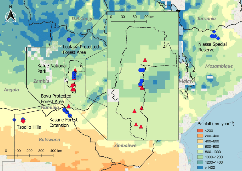
Distribution of plots in southern Africa across study sites in Tsodilo Hills (NW Botswana), Kasane Forest Extension (NE Botswana), Bovu Protected Forest Area (SW Zambia), Kafue National Park (dotted line, W Zambia), Lualaba Protected Forest Area (NW Zambia) and Niassa Special Reserve (N Mozambique). Early dry season plots have blue markers, and late dry season plots have red markers. Diamond-shaped markers represent plots established in 2019, triangular-shaped markers represent plots established in 2021 and circular markers those established in 2022.
Fuel load
The process of creating detailed biomass maps for KNP began with building an inventory through in situ measurements. This consisted of measuring different categories of fuel within groups of transects in a single plot, which was simultaneously surveyed with a UAV-mounted camera. Orthophotos were created encompassing all transects within a plot, and individual transects were demarcated within this orthophoto. Using UAV-based features and the meteorological history of the plot, an RF model was created to predict biomass for the entire orthophoto (hereafter UAV model). These biomass orthophotos were then distributed across Sentinel-2 pixels to form a training set for a second RF model, which predicted biomass on the basis of exclusively Sentinel-2-derived features (hereafter S2 model). This was then used to create a map of monthly biomass in KNP, on the basis of Sentinel-2 imagery. These steps are detailed in the following sections.
The field measurements on which the UAV model was based were taken across several campaigns in 2019 (April–July and September–October), 2021 (October–November) and 2022 (May–June), in Kafue itself as well as the greater southern African savanna region. Measurements were taken in different fuel (vegetation) classes in plots consisting each of two or three transects 50 m in length following protocols outlined in Eames et al. (2021), Russell-Smith et al. (2009) and Yates et al. (2015). The key fuel classes are described in Table 1. Heavy woody material is excluded from the remainder of the paper as although it could be detected within UAV images, other factors such as the state of decay of such items could not, making biomass in this category extremely challenging to quantify. Further, it does not contribute substantially to total biomass and is not regularly consumed in savanna fires (Eames et al. 2021). Trees also presented a challenge as they have a significant structural (i.e. 3-dimensional) component, and were also excluded from the UAV and Sentinel-2 models. This fuel class was instead included using Synthetic Aperture Radar (SAR)-based methods, which include structural information (Bouvet et al. 2018). Coarse fuel is challenging particularly owing to the somewhat arbitrary way in which it accumulates. Although litterfall is a more regular process driven in part by seasonal changes, coarse woody debris accumulation is driven partially by animal interaction, high winds or other extreme weather, logging or other human activity, and possibly other stochastic processes. Litter is also predominantly dead leaf and grass material (Costa et al. 2020), but forms a more continuous layer and is easier to see in UAV images than woody material. Nonetheless, it is reasonable to assume that any process that adds to the coarse woody debris pool would also add to the litter fuel load. We therefore model coarse woody debris by assuming a linear relationship with litter (see Supplementary Material S3, Fig. S3). Fuel load in the tropical savannas is strongly related to mean annual precipitation (Good and Caylor 2011; Lin et al. 2024; Williams et al. 2024). To better cover the lower part of the rainfall gradient, fuel plots from Australian savannas were also included. Given the focus on Africa in the rest of the text, these are not given separate consideration in the body of the paper, however. For details on these plots, see Supplementary Material S5.
| Fuel class | Description | |
|---|---|---|
| Grass | Any rooted grass, both live grasses along with any dead grass stands still rooted or attached to other live stalks | |
| Litter | Dead grasses on the ground, dead leaves, woody material with diameter 5 mm or less | |
| Total fine fuel | Sum of the Grass and Litter categories | |
| Coarse | Dead woody material with diameter larger than 6 mm and smaller than 5 cm | |
| Heavy | Dead woody material with diameter larger than 5 cm | |
| Shrubs | Live standing woody (including leaves where present) vegetation with a diameter at breast height (DBH) of less than 5 cm and/or height less than 2 m | |
| Trees | Live standing woody (including leaves where present) vegetation with DBH of 5 cm or more and/or a height of 2 m or greater |
A total of 182 transects in 63 plots were measured (excluding those in Australia) spread across savannas in three countries, across rainfall gradients from as low as 600 mm year−1 to upwards of 1200 mm year−1. The locations of these plots are shown in Fig. 1 and an overview is found in Table 2.
| Site name | Mean annual precipitation (mm year−1) | Soil description | Number of transects | |
|---|---|---|---|---|
| Tsodilo Hills | 700 | Sand/sandy clay | 28 | |
| Kasane Forest Extension | 750 | Sand, red brown sand | 33 | |
| Bovu protected forest area | 900 | Sand | 9 | |
| Kafue National Park | 900–1100 | Sand, sandy loam | 57 | |
| Lualaba protected forest area | 1200–1300 | Sandy loam | 27 | |
| Niassa special reserve | 1000–1100 | Sandy loam | 18 | |
| Lajamanu (NT, Australia) | 600 | Sand | 43 | |
| Great Sandy Desert (WA, Australia) | 500 | Sand | 24 |
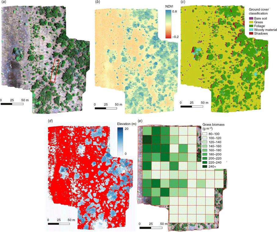
Two UAV systems were used to survey the plots. The first was a DJI Matrice 100 with a mounted MicaSense RedEdge Multispectral camera, used to survey all plots laid in 2019. The second was a DJI Phantom P4 Multispectral, used to survey 2021 and 2022 plots. Both systems made use of the same software for image capture and processing (DJI Groundstation Pro and DJI Terra respectively) and the flight parameters were kept the same for both systems: altitude was fixed at 50 m and image overlap set to 80%, such that after stitching, the orthophotos had a resolution of 5 cm. Flight times were restricted to between 10:00 and 15:00 hours daily so as to avoid flying under low sun angles. Weather conditions while sampling were almost exclusively cloudless. Both cameras share the same five bands – blue, green, red, red edge and near infrared. In some bands, there is less overlap between the two cameras than in others, although for the longer wavelengths predominantly used in this study, the effect is less pronounced. Although we do expect there to be some difference in vegetation indices (VIs) calculated from bands that are not identical (Teillet et al. 1997), there is generally a strong correlation between VIs across different UAV-mounted instruments (Deng et al. 2018) and the measurements were taken in regions with similar features and under similar weather conditions. Furthermore, much of the UAV-generated data we rely on in this study are band-independent. Classification maps (Fig. 2c) and digital elevation models (DEMs, Fig. 2d) were generated individually for each orthophoto using the same algorithms as a method of fully unifying data captured by two similar but separate systems. For FL quantification, fuel class maps were generated using Geographical Object-Based Image Analysis (GEOBIA, Clewley et al. 2014) and combined with selected VIs and meteorological history from ERA5 Land hourly data (Hersbach et al. 2020). Each transect was ascribed a set of features listed in Table 3. Descriptions of the processes involved in obtaining these features are found in Eames et al. (2021). Examples of features obtained from UAV systems after post-processing are shown in Fig. 2. Once all features for each transect had been collected, they were fed together with the fuel measurements for each fuel category (Table 1) into an RF model (Breiman 2001; Geurts et al. 2006) implemented in Python (Pedregosa et al. 2011) with 10-fold cross-validation. Hyper-parameter tuning was done using a randomised grid method. A total of 20% of data points was kept aside for validation purposes. Tree biomass was developed separately by directly linking SAR backscattering from the Advanced Land Observing Satellite Phased Array type L-band Synthetic Aperture Radar (ALOS-PALSAR) to tree biomass, in combination with LiDAR validation and ground-based measurements (Bouvet et al. 2018). The degree of RADAR backscattering is directly linked to the amount of standing vegetation in dry and open biomes such as savannas. Bouvet et al. (2018) matched in situ measurements from plots across the African continent with backscatter data, and related them via a semi-empirical exponential equation corresponding to the modified Water Cloud Model (Santoro et al. 2002). The 25 m source data were regridded to 20 m using a weighted averaging algorithm within the boundaries of KNP to match with the Sentinel-2 grid. Following on from the UAV model creation, a 20 m Sentinel-2 grid was overlaid on each orthophoto, and features in Table 3 were extracted and calculated for each grid cell fully within the orthophoto. The UAV model was then applied to these grid cells, resulting in a 20 m resolution biomass map. An example of this is shown in Fig. 2e. Each grid cell was paired with a Sentinel-2 pixel from the most recent overpass previous to the UAV flight. The Sentinel-2 twin satellites provide a 5-day revisit time over Southern Africa, though in some rare cases, cloud cover and cloud shadow resulted in the most recent image being unusable. In these cases, the next available cloud-free image was used, up to a maximum period of 1 month before the UAV flight date. The total fine fuel class performed approximately as well in the UAV RF model as grass and better than litter (shown in Results section). Consequently, only the total fine fuel class was used to train the S2 model instead of using separate models for grass and litter. However, litter will continue to be included in its function as a proxy for coarse woody debris.
Example orthophoto from the Phantom P4 Multispectral camera in Kafue National Park (15°24′26.6″S, 25°55′12.5″E). The red-green-blue (RGB) image is shown in (a) along with an example transect (red box). The Normalised Difference Vegetation Index (NDVI) for this orthophoto is shown in (b), the GEOBIA classification in (c), and DEM in (d). Red areas in the DEM are equivalent to an elevation of 0 m (ground). Panel (e) shows the UAV model output for grass on a Sentinel-2 20 m grid.
| Feature name | Source | Description | |
|---|---|---|---|
| Digital Elevation Model (DEM) | UAV | Mean canopy height from a photogrammetry-derived elevation model | |
| Burned Area Index (BAI) | UAV | Mean burned area index value (Martín et al. 2006) | |
| Leaf Chlorophyll Index (LCI) | UAV | Mean leaf chlorophyll index value (Datt 1999) | |
| Normalised Difference Vegetation Index (NDVI) | UAV | Mean NDVI value (Tucker 1979) | |
| Near infra-red (NIR) | UAV | Mean reflectance in the NIR band | |
| Proportion of bare soil | UAV | Fraction of the transect classified as bare soil | |
| Proportion of foliage | UAV | Fraction of the transect classified as foliage of live leaf material | |
| Proportion of grass | UAV | Fraction of the transect classified as grass-covered | |
| Proportion of wood | UAV | Fraction of the transect classified as woody material, live or dead | |
| Sum of precipitation | ERA5 | Total precipitation (mm) since the last fire | |
| Mean annual precipitation | ERA5 | Mean annual precipitation (mm) in the period since the last fire | |
| Mean surface solar radiation | ERA5 | Mean solar radiation (J m−2) incident on the transect since the last fire | |
| Total evaporation | ERA5 | Total depth (m) of water equivalent evaporated from the transect since the last fire | |
| Shrub fraction | UAV | Fraction of the transect classified as shrub | |
| Shrub percentage | UAV | Fraction of the total canopy within the transect classified as shrub |
A total of 4654 Sentinel-2 grid cells were matched with fuel data from the orthophoto outputs of the UAV model. The second RF model (S2 model) was set up with the same parameters as described for the UAV model (10-fold cross validation, random grid search hyper-parameter tuning and 20% of data points kept aside for validation). Only 3 of the 11 available bands from the Sentinel-2 MultiSpectral Instrument (MSI) were used, the others being discarded due to high cross-correlation. We chose to keep red (band 4), near-infrared (NIR, band 8A) and short-wave infra-red (SWIR, band 12). Additional information on land cover at 20 m resolution was taken from the prototype land cover (LC) product created by the European Space Agency’s (ESA) Climate Change Initiative (https://2016africalandcover20m.esrin.esa.int/, accessed 25 March 2025). This product is experimental and currently only available for the year 2016, so we visually inspected LC classes and compared them with our own UAV images and other satellite-generated imagery for the relevant period (e.g. from Google Earth). Although there were some minimal localised discrepancies, generally the LC product did well in differentiating larger-scale grasslands and dambos from forested areas or areas with dominant shrub cover for our period of interest. These larger-scale landscape features also do not change substantially over the course of a few years, so in this instance, the effect of the mismatch in timing is likely minimal. The S2 model was applied to a cloud-free monthly mosaic of atmospherically corrected Sentinel-2 data across the whole of KNP. If a grid cell had more than one cloud-free data point within the month, an average of the available reflectance values was taken. This pre-processing was done in Google Earth Engine (Gorelick et al. 2017). The output was further masked by the accompanying Scene Classification from Sentinel-2, where any grid cell that was not designated as either vegetation or bare soil was masked. This was done only for the year 2019, as for this year a Sentinel-2 pixel-scale BA product is available from ESA’s FireCCI (FireCCISFD20, Chuvieco et al. 2022). Monthly maps for total fine fuel, coarse woody debris (via litter) and shrub biomass were produced in this way. Satellites cannot see dry weight – observations are necessarily of wet weight and thus all steps outlined until this point were taken using wet weight rather than dry weight. For emissions calculation, it is however necessary to convert this wet weight into DM. Fuel moisture content (FMC) was measured in the field campaign, but producing a map of fuel moisture on a larger scale is not straightforward. As in savannas especially surface vegetation (grasses, with shallow roots) is affected more directly by soil moisture (Williams and Albertson 2004), we elected to scale the range of measured FMCs using soil moisture (SM) products as a proxy. We used SM data from NASA’s soil moisture active passive (SMAP) Level-4 9 km 3-hourly data version 7 (Reichle et al. 2022), averaged on a daily basis. Measured FMC ranges used are shown in Table 4. Total DM was calculated on a monthly basis by taking the lowest and highest FMC measurement from in situ data for each fuel class as the minimum and maximum FMC values, and then using SM observations as a scalar such that maximum FMC corresponded to the highest observed SM, and minimum FMC with the lowest. For BA products with only burn month available (Yates, GFED5 – see below), this monthly DM layer was used for the emissions calculations. For the other products (FireCCI and MODIS), which have day of burn data available, the average SM of the 14 days previous to the burn was used to scale the FMC. Standing vegetation is affected differently by SM (Mazzacavallo and Kulmatiski 2015), but because tree biomass was calculated with the use of allometric equations that are already calibrated for DM, no correction is necessary for this class.
| Fuel class | Error | CC range (%) | FMC range (%) | |
|---|---|---|---|---|
| Total fine | ±146 g m−2 (27%) | 70–100 | 5–40 | |
| Coarse | ±289 g m−2 (112%) | 20–60 | 1–10 | |
| Shrubs | ±240 g m−2 (107%) | 0–40 | 30–60 | |
| Trees | 11% (see Bouvet et al. 2018) | 0–1 | Not applicable |
Burned area
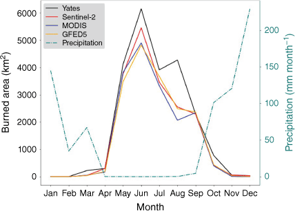
Three different sources of BA data were used for the study area in 2019. The lowest-resolution dataset used was the 500 m MODIS MCD64A1 Collection 6.1 dataset (Giglio et al. 2018), available on a daily basis. The second was FireCCISFD20 (Chuvieco et al. 2022), a 20 m product based on images from the twin Sentinel-2 satellites. The final BA dataset (hereafter referred to as the Yates dataset) was produced manually for 90% of KNP’s area from 30 m Landsat imagery using methods similar to the North Australia and Rangelands Fire Information project (NAFI, https://firenorth.org.au/). Using indices incorporating the NIR and SWIR sections of the spectrum that are sensitive to changes in vegetation such that burn scars are easily detectable (Garcia and Caselles 1991; Pereira et al. 1999), these potential burn scars were mapped using a threshold, and then examined visually to identify and filter areas where the indices were confounded by non-fire related processes, e.g. surface water changes including flooding or drought (Evans and Russell-Smith 2020). The narrow western section of the park not covered by the Yates dataset was supplemented by FireCCISFD20 BA. As this dataset was developed under scrutiny of the KNP area in particular, it will be assumed to be the most accurate for the remainder of this paper. A comparison of the different BA products listed, including a MODIS-based BA with statistically modelled ‘small fires’ from GFED5 (Chen et al. 2023), is shown in Fig. 3.
Burned area from satellite-derived products in the year 2019. The red line is FireCCISFD20 derived from the Sentinel-2 MSI, the blue line is MODIS MCD64A1 C6.1, the yellow line MODIS-based GFED5 burned area including small fires, and the black line the manually compiled Yates dataset based on Landsat-8 imagery. The blue dotted line and corresponding right-hand side y-axis shows the mean monthly rainfall for KNP in 2019 (Hersbach et al. 2020). In the peak burn month (June), approximately one-quarter of the park area is burned.
Combustion completeness
Combustion completeness (CC) is the fraction of available FL consumed in the process of biomass burning. This varies according to fuel class, fuel/soil moisture, and weather conditions (van Leeuwen et al. 2014; Russell-Smith et al. 2021). Generally speaking, surface fuels burn most completely, and larger surface-level objects such as coarse woody debris or young shrubs are consumed to a lesser degree, either because of retained moisture in live standing fuel or because fires pass through too quickly to ignite larger objects. Mature trees are consumed the least and usually remain unaffected by less severe fires (Russell-Smith et al. 2009). It is difficult to account for local weather and wind conditions that might affect CC for one particular fire, as these can be very small scale and change rapidly during the course of the fire itself. This makes mapping CC on a pixel level exceedingly challenging. CC is, however, related to environmental water content (Shea et al. 1996 – see also Supplementary Material S4, Fig. S6). We therefore use SM data again as a basis for a general CC map for KNP. We broadly follow the methods used in van Wees et al. (2022), employing an SM-derived scalar (ϵSM, Eqn 2) to scale CC. In our case, the SMAP data were averaged to monthly values to scale between a CC range for each fuel class (Table 4). These ranges were adjusted from van Wees et al. (2022) and augmented with other field data from van Leeuwen et al. (2014) to match CC ranges from field measurements within KNP. We acknowledge that this does not account for all the factors influencing CC, but in this context represents an adequate solution to the challenge continuous CC representation in large-scale modelling presents. The scalar used for pixel x and time t is:
where 0.45 m3 m−3 is the typical maximum SM outside wetland areas (van Wees et al. 2022). The role of fire in relation to trees in tropical savannas is almost always as a sapling removal mechanism rather than directly affecting adult trees (Higgins et al. 2000; Ojeda et al. 2005) and in KNP in 2019, Global Forest Change data (https://glad.earthengine.app/view/global-forest-change) based on 30 m Landsat imagery showed little forest loss, and none due to fire (Tyukavina et al. 2022). We therefore expect extremely limited combustion within the tree pool, though set the maximum CC above zero (1%) to allow for the possibility of single trees smaller than the Landsat pixel size being consumed and not registered.
Interannual variability in KNP
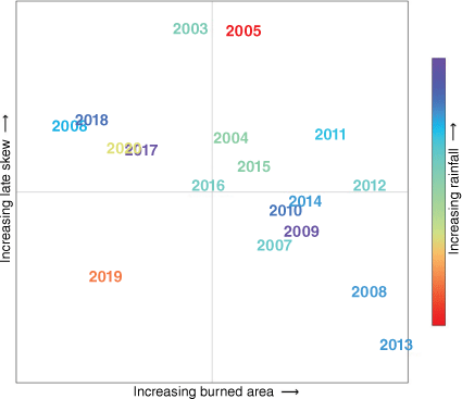
By using a high-resolution FL dataset such as the one presented in this paper, it becomes possible to thoroughly investigate changes in emissions due to differing burning patterns localised to the park. To this end, we selected four individual years in the last two decades. We selected these years based on two criteria: total area burned and timing of the burns, i.e. whether the fire season was skewed towards the early or late end of the dry season. For this, we used BA data from Chen et al. (2023), available for the years 1997–2020. We excluded the years pre-2003 for consistency, as this represents the pre-Aqua MODIS era. For our comparison, we selected the years 2019 (low BA, early skew), 2013 (high BA, early skew), 2011 (high BA, late skew) and 2018 (low BA, late skew); see Fig. 4.
Burn patterns for each year from 2003 to 2020, using BA including small fires from Chen et al. (2023). All axes (including the colour bar) are relative.
GFED5 BA data were only available on a coarse grid (0.25°). As such, the ratio of burn patterns from year to year was used to adjust the Yates BA dataset for years other than 2019, rather than directly used in calculations. Emissions calculated for each year make use of variable EFs from Vernooij et al. (2023), and are presented as net emissions – that is, including only CH4 and N2O (Lipsett-Moore et al. 2018).
Results
Biomass model
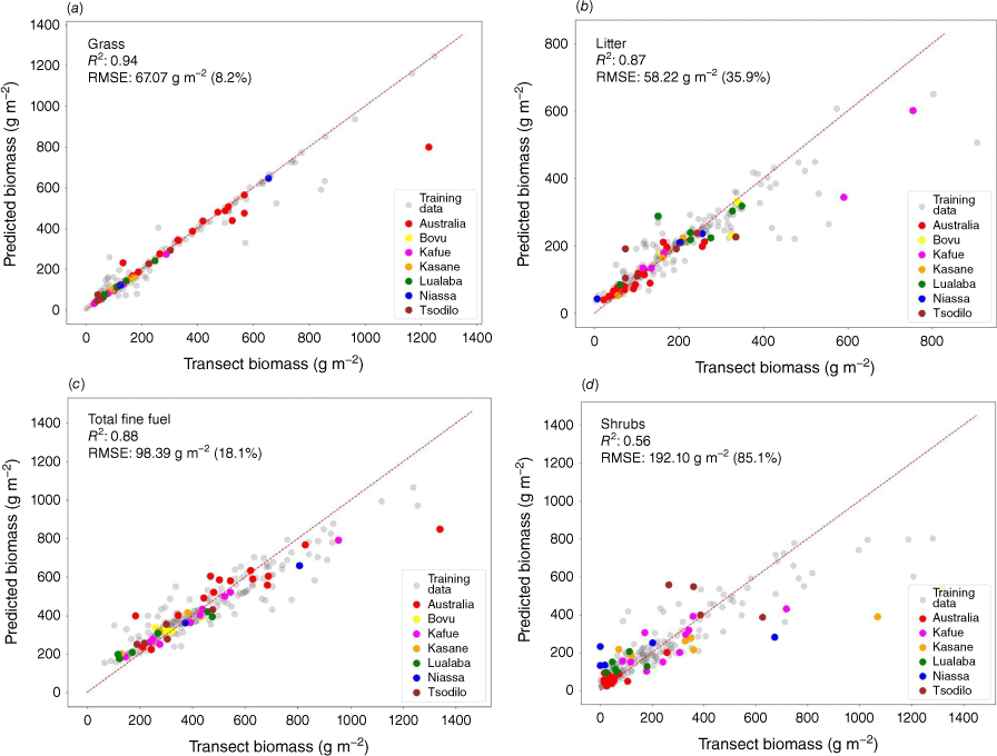
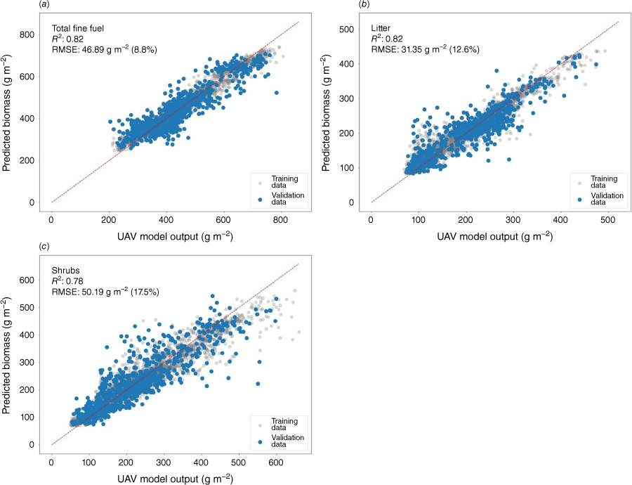
Results for the UAV model are shown in Fig. 5, comparing modelled with measured fuel loads for different fuel classes. R2 values for surface fuels are all greater than 0.8, and for the combined total fine class, the mean percentage error is less than 20%. The model performs less well on the shrub class, R2 being a somewhat lower 0.56 with a mean percentage error of just under 90%. The outputs of the S2 model are shown in Fig. 6. All classes have an R2 of ~0.8. Percentage error margins are lower than in the UAV model but follow a similar pattern: lowest for total fine (9%), then litter (13%) and highest for shrubs (18%). Cumulative error for the final FL model is calculated as the sum of the root mean square errors (RMSEs) for both UAV and S2 models, and is shown in Table 4. Error is lowest for total fine fuel at ~27%, and much higher for the other classes at ~110%. Measurement error on trees in KNP is approximately 11%.
UAV RF model output compared with in situ FL measurements for wet weights of (a) grass, (b) litter, (c) total fine fuel, and (d) shrubs for both training and validation data. R2 values are displayed in the top left-hand corner of each fuel class graph, along with root mean square error (RMSE) values. In parentheses are the average percentage errors. The red dotted line shows the 1:1 line. Training data are also shown as grey dots.
Sentinel-2 RF model output compared with UAV model output for wet weights of (a) total fine fuel, (b) litter (as a proxy for coarse), and (c) shrubs for both training and validation data. R2 values are displayed in the top left-hand corner of each fuel class graph, along with root mean square error (RMSE) values. In parentheses are the average percentage errors. The red dotted line shows the 1:1 line. Training data are shown as grey dots.
Observational emissions
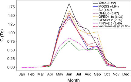
Emissions were calculated with Eqn 1 using the observational BA datasets and total DM from the UAV + S2 model. Total observed emissions for KNP in 2019 from various sources, expressed in teragrams of carbon, are shown in Fig. 7. Emissions calculated for 2019 from BA-based methods were between 5 and 6 Tg C. Pure MODIS BA-based emissions were only marginally (2%) lower than the FireCCI-based BA (4.9 and 5.1 Tg C respectively). The Yates BA-derived dataset has the highest emissions of 6.2 Tg C. Two independent emission datasets, FINN2.5 and GFAS1.2, give approximately half the carbon emissions compared with other methods for 2019 at 3.4 and 2.9 Tg C respectively. The spread of emissions is similar across all the different models – in 2019, the fire season began in March/April, peaking in June and dropping off substantially by October. The peak months (May, June, July) are where BA-based methods exceed other emissions calculation methods by as much as a factor of 2.8. BA-based emissions are largely similar in the peak months but begin to diverge later in the season (August and September). All methods show similar, low levels of biomass burning emissions for the fringe months of the fire season (March, April, October–December).
Total emissions from biomass burning in KNP from CO, CO2, CH4, black carbon and organic carbon for the year 2019, expressed in teragrams of carbon. Solid lines indicate emissions calculated using biomass layers generated using the UAV + S2 model, EFs from Vernooij et al. (2023) and BA products, while dotted lines indicate emissions taken directly from extant models. In parentheses in the legend is the total amount of carbon emitted in 2019 for each method.
Inter-annual variability
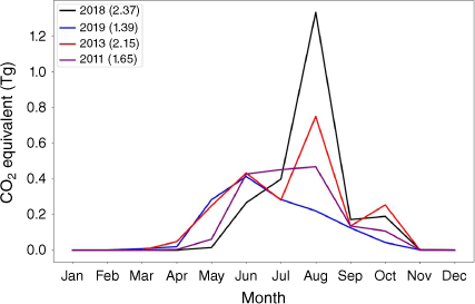
For coherence, in this section, we switch from reporting emissions in teragrams of carbon to teragrams CO2 equivalent, and include four major emitted species related to biomass burning: CO2, CO, CH4 and N2O. ‘Net emissions’ refers to total emissions from only CH4 and N2O. Of the years chosen, net emissions were highest in 2018 at 2.37 Tg CO2 equivalent, and lowest in 2019 at 1.39 Tg CO2 equivalent. The year with the highest BA, 2013, had marginally lower net emissions than 2018 (2.15), mostly owing to the high peak of BA in August (Fig. 8). Monthly net emissions for the year 2019 peaked in June, whereas for all other years considered, the peak fell in August. A breakdown of emissions by year and species is shown in Table 5.
Discussion
Fuel
The layer for which the fuel load model performs best is the mostly continuous surface fuel layer. Somewhat continuous layers with a vertical aspect (standing biomass, i.e. shrubs and trees) prove difficult to model using only 2D and height data (2D UAV or satellite-generated maps with DEMs, sometimes referred to as 2.5D data). It appears that, at least for this part of the miombo, tree or woody cover data are insufficient to get a clear picture of this biomass pool, and information about the structure of the vegetation is still necessary – such as that provided by RADAR backscattering in Bouvet et al. (2018) or via point clouds generated with LiDAR instruments (Wang et al. 2021; Qin et al. 2022). In our case, the uncertainty in the shrub class is still within a useful range, likely owing to the fact that shrubs are by definition limited in size and extent (less than 2 m), which in turn places limits on the range of biomass available in the shrub layer and creates a stronger link between surface cover and biomass – especially in savannas with broken canopy cover. This may be the main reason why it is still possible to get a reasonable AGB estimate for the shrub layer from 2.5 days’ data. With the methods applied in this paper, the tree layer proved impossible to model to a degree of accuracy that would be useful, and we conclude that proper three-dimensional structural data are necessary to capture this layer effectively. Error margins are nonetheless high for shrubs and coarse woody debris fuel classes. Although of course a lower margin of error is desirable in all cases, the coarse and shrub fuel classes are a minority contribution to total fuel consumption within KNP. Total fine fuel constitutes 60–70% of biomass burned. Coarse woody debris is the second most important fuel class, constituting less than 20% of biomass consumed. The majority of fuel consumed is therefore relatively well constrained, and the highest uncertainty in fuel load affects <25% of the total fuel consumed. In this area, future improvements could involve the use of high-resolution ground-based LiDAR to better detect small woody objects on the ground, as these proved elusive even with 5 cm resolution imagery available. This would also likely improve the shrub layer biomass with the addition of more detailed structural data. In this study, and in other studies involving larger-scale fuel consumption (e.g. van der Werf et al. 2017; van Wees et al. 2022), CC is assigned rather than measured via proxies. In our particular case, CC was assigned on the basis of a reasonable range constrained by measurements taken within KNP and moisture content. The determinants of CC in savannas include moisture content, wind speed, flame length and fuel load (Ward et al. 1996; Hély et al. 2003), though for savanna grasses at least, the direct link between moisture content and CC is strong (Hély et al. 2003). As the precipitation pattern in 2019 showed a sharp drop to practically zero from April until September, when almost all burning took place (Fig. 3), we can at least be confident that moisture content of the grasses (and likely the total fine fuel layer) for approximately 85% of the burned area was extremely low (approaching zero) and changed minimally during the season. As a result, we can be more confident that the CC parameter of this dominant fuel layer is consistently high – with some degree of uncertainty regarding the other aforementioned factors. The CC of the other layers is less certain, but the scaling approach is nonetheless one step up from larger-scale models such as GFED in the sense that we constrained CC values to ranges based on field measurements from KNP itself.
Emission models
There are three primary methods used by the fire emission models discussed in this paper to track fire activity. These are BA mapping (GFED4.1s, preliminary GFED5 and the various BA products combined with the UAV + S2 fuel layer), tracking fire activity through hotspot detection in combination with fixed FL values per biome (FINN2.5) or directly related to fire radiative energy (FRE, GFASv1.2). It is clear from Fig. 7 that the BA-based methods calculate substantially higher biomass burning emissions of total carbon for KNP. FINN2.5-derived emissions are substantially lower than GFED or UAV + S2 derived emissions as the FL in FINN2.5 is fixed across the entire southern African savanna to just over 400 g m−2 (Wiedinmyer et al. 2023). This single value may be sufficient when considering southern African savannas as a whole, but is likely to be too low for much of KNP (see for example pink scatter dots in Fig. 5c, d, which themselves do not include tree biomass). Another possible cause of FINN2.5 showing lower emissions is the effect of using non-BA based methods for emissions calculation. Southern African savanna fires are generally faster-moving than others (Andela et al. 2019), which may limit the number of active fire detections in relation to fire size, and result in an underestimation of total burning in KNP within FINN2.5. A seemingly likely reason for the underestimation of GFASv1.2 in KNP (and also possibly elsewhere) is the tuning of GFAS to an older version of GFED (GFED3) that did not include small fires (≤100 ha). Small fires are shown to make up a significant proportion of fires worldwide, including in southern Africa (Ramo et al. 2021). However, although BA products generated on a coarser resolution (e.g. MODIS) and those on a finer grid (FireC- CISFD20) are not identical in KNP (Fig. 3), the difference is not large enough to account fully for the difference between the updated GFED versions and GFAS. One possible alternative explanation is that there is a fixed conversion factor between FRE and quantity of DM consumed for all savannas, similar to the fixed FL value in FINN. This is speculative, however, as it is hard to say how fires in KNP diverge from this value (if at all) without substantive further study. A final (and less speculative) reason for underestimation in GFAS emissions is the effect of fires beneath a canopy on measured FRE. Roberts et al. (2018) showed that a vegetation canopy can be very effective in reducing the FRE values detected at the sensor, even with broken cover. Wooded savannas have enough open space in canopy cover for visual or thermal fire detection methods (BA and active fire hotspots) to function without significant detriment even for sub-canopy fires, but FRE-based methods may suffer disproportionately in these regions. The similarity of FireCCISFD20 and MODIS-generated burned area datasets within KNP, implying a small proportion of small fires, is not unexpected. National parks or protected areas seem to be more likely to have more spatially extensive fires, owing to higher fuel connectivity and lower human footprint (Archibald et al. 2010; Eames et al. 2023). This will minimise divergence between these two BA datasets in our study area. There are few FL datasets available for the savanna region, or on a global scale, that include all fuel layers considered in this paper. An exception to this is van Wees et al. (2022), though the output of their model is DM consumed rather than a single DM layer. As this fuel consumption layer is based on MODIS BA and CC values used largely similar to those in this study, comparison of emissions generated from van Wees et al. (2022) and the UAV + S2 model combined with MODIS BA is a good (albeit indirect) method of comparing FL in both approaches. The correlation between these two datasets is extremely high and the monthly emissions are also of a very similar magnitude (Fig. 7), indicating a good agreement within the FL layer in general. However, van Wees et al. (2022) allow for a larger proportion of adult trees being consumed in fires. The fact that FL is nonetheless similar indicates that woody biomass consumption is overestimated in van Wees et al. (2022), and surface fuel underestimated within KNP. We also cannot, however, rule out at least part of this likely discrepancy coming from the fairly poorly constrained coarse woody debris layer. This incidentally also holds true for GFED4.1s and GFED5. Although both GFED versions use a slightly modified version of the MODIS BA dataset, less than 1% of the explained variance between the emissions outputs from GFED and the MODIS UAV + S2 model comes from discrepancies in the BA product used. The high level of agreement in both cases is therefore a result of a generally good match in overall FL between the two approaches, besides the likely differences in internal biomass consumption pools.
Inter-annual variability
Of the 4 years chosen, 2018 has by far the highest net emissions, a large part of which occurs in August. It seems as though the bulk of the fire season in 2018 was delayed until this point, seen in the relatively low emissions in the preceding months when compared with the other years. EFs for N2O and especially CH4 are higher in 2018 across the entire season (Vernooij et al. 2023), suggesting less dry and efficient burning conditions. Indeed, ERA5 data (Hersbach et al. 2020) show that not only did the 2018 wet season have the highest total precipitation (precipitation summed from July 2017 to June 2018), the bulk of this precipitation fell in the latter part of the wet season, around February. This could explain why the 2018 fire season was delayed, and also why conditions were conducive to high net emissions in that year. In contrast, precipitation in the 2018–2019 wet season was much more limited, and very little occurred in the latter portion. Conditions were likely then more conducive to burning earlier in the season, as well as more complete combustion throughout and especially in the latter part of the season. The year 2019 had the highest BA in the early dry season months (April–June) and the lowest BA overall, as well as the lowest overall net emissions. It may be that enough burning occurred in 2018 to limit the amount of BA possible in 2019; however, given the relatively low total BA for 2018, this seems less likely (see Fig. 4). Early season burning is more likely to form a patchwork of small fire scars (Ramo et al. 2021), which can prevent more extensive later season burning (Parr and Brockett 1999; Laris 2002; van Wilgen et al. 2014). Care must be taken with this conclusion from a solely emissions perspective, as applying this thinking in a wetter year such as 2018 may perhaps result in higher net emissions. The effects of savanna fire burning patterns on GHG emissions, and radiative forcing more generally, is an area where more research is needed and will be the subject of a future paper.
Conclusions
We introduced a biomass model, built from in situ fuel measurements, that performs well for the key fuel classes in tropical savannas. The high resolution of this biomass model, combined with the latest developments in calculating emission factors and a tailor-made BA product, has made it possible to examine pyrogenic greenhouse gas emissions in detail from one of southern Africa’s largest protected areas. Compared with our results, we find that other emissions models likely underestimate total carbon emissions by 18% (GFED4s) to just over 60% (GFASv1.2) in this area. Although we have focused on KNP in particular, the methods set out in this paper can be applied to a detailed calculation of greenhouse gas emissions on a regional or even continental scale. These emission data can then potentially be fed into chemically coupled numerical weather prediction models such as WRF-chem, and this will be the subject of further research.
Conflicts of interest
Roland Vernooij and Jeremy Russell-Smith are Associate Editors of International Journal of Wildland Fire. To mitigate this potential conflict of interest they had no editor-level access to this manuscript during peer review. The authors declare no other conflicts of interest.
Declaration of funding
This research was carried out with support of the 2017 Ammodo Science Award for Natural Sciences. Fieldwork was partially supported by the United Nations Green Climate Fund.
Acknowledgements
The authors are grateful for the use of the BAZIS cluster at VU Amsterdam, without which much of this work would not have been possible. Our thanks go to the staff at the Department for National Parks and Wildlife in Zambia who assisted us in the field and made our stay in Kafue National Park possible. We also extend our thanks to Alexandre Bouvet for kindly providing access to the tree biomass data used in this study.
Author contributions
Tom Eames: conceptualisation, methodology, software, investigation, formal analysis, writing – original draft, visualisation. Adrian Kaluka: investigation, validation, writing – review and editing. Roland Vernooij: investigation, formal analysis. Cameron Yates: investigation, formal analysis, writing – review and editing. Jeremy Russell-Smith: conceptualisation, writing – review and editing, supervision. Guido R. van der Werf: conceptualisation, writing – review and editing, funding acquisition, supervision.
References
Andela N, Morton DC, Giglio L, Paugam R, Chen Y, Hantson S, van der Werf GR, Randerson JT (2019) The Global Fire Atlas of individual fire size, duration, speed and direction. Earth System Science Data 11(2), 529-552.
| Crossref | Google Scholar |
Archibald S (2016) Managing the human component of fire regimes: lessons from Africa. Philosophical Transactions of the Royal Society B: Biological Sciences 371, 20150346.
| Crossref | Google Scholar |
Archibald S, Roy DP, van Wilgen BW, Scholes RJ (2009) What limits fire? An examination of drivers of burnt area in southern Africa. Global Change Biology 15(3), 613-630.
| Crossref | Google Scholar |
Archibald S, Scholes RJ, Roy DP, Roberts G, Boschetti L (2010) Southern African fire regimes as revealed by remote sensing. International Journal of Wildland Fire 19(7), 861-878.
| Crossref | Google Scholar |
Avitabile V, Herold M, Heuvelink GB, et al. (2016) An integrated pan-tropical biomass map using multiple reference datasets. Global Change Biology 22(4), 1406-1420.
| Crossref | Google Scholar | PubMed |
Bond W, Keane R (2017) Fires, Ecological Effects of. In ‘Reference Module in Life Sciences’. 2nd edn. (Ed. Simon A Levin) pp. 1–11. (Elsevier). 10.1016/B978-0-12-809633-8.02098-7
Bouvet A, Mermoz S, Toan TL, Villard L, Mathieu R, Naidoo L, Asner GP (2018) An above-ground biomass map of African savannahs and woodlands at 25 m resolution derived from ALOS PALSAR. Remote Sensing of Environment 206, 156-173.
| Crossref | Google Scholar |
Breiman L (2001) Random forests. Machine Learning 45(1), 5-32.
| Google Scholar |
Chen Y, Hall J, van Wees D, Andela N, Hantson S, Giglio L, van der Werf GR, Morton DC, JT Randerson (2023) Multi-decadal trends and variability in burned area from the 5th version of the Global Fire Emissions Database (GFED5). Earth System Science Data 15, 5227-5259.
| Crossref | Google Scholar |
Chuvieco E, Roteta E, Sali M, et al. (2022) Building a small fire database for sub-Saharan Africa from Sentinel-2 high-resolution images. Science of The Total Environment 845, 157139.
| Crossref | Google Scholar | PubMed |
Clewley D, Bunting P, Shepherd J, Gillingham S, Flood N, Dymond J, Lucas R, Armston J, Moghaddam M (2014) A python-based open source system for Geographic Object-Based Image Analysis (GEOBIA) utilizing raster attribute tables. Remote Sensing 6(7), 6111-6135.
| Crossref | Google Scholar |
Costa A, Bruna E, Vieira-Neto E (2020) Annual litter production in a Brazilian Cerrado woodland savanna. Southern Forests: a Journal of Forest Science 82, 65-69.
| Crossref | Google Scholar |
Datt B (1999) A new reflectance index for remote sensing of chlorophyll content in higher plants: tests using eucalyptus leaves. Journal of Plant Physiology 154(1), 30-36.
| Crossref | Google Scholar |
Deng L, Mao Z, Li X, Hu Z, Duan F, Yan Y (2018) UAV-based multispectral remote sensing for precision agriculture: a comparison between different cameras. ISPRS Journal of Photogrammetry and Remote Sensing 146, 124-136.
| Crossref | Google Scholar |
Djeumen IY, Dumont Y, Doizy A, Couteron P (2021) A minimalistic model of vegetation physiognomies in the savanna biome. Ecological Modelling 440, 109381.
| Crossref | Google Scholar |
Eames T, Russell-Smith J, Yates C, Edwards A, Vernooij R, Ribeiro N, Steinbruch F, van der Werf GR (2021) Instantaneous pre-fire biomass and fuel load measurements from multi-spectral UAS mapping in southern African Savannas. Fire 4(1), 2.
| Crossref | Google Scholar |
Eames T, Vernooij R, Russell-Smith J, Yates C, Edwards A, van der Werf GR (2023) Division of the tropical savanna fire season into early and late dry season burning using MODIS active fires. International Journal of Applied Earth Observation and Geoinformation 125, 103575.
| Crossref | Google Scholar |
Evans J, Russell-Smith J (2020) Delivering effective savanna fire management for defined biodiversity conservation outcomes: an Arnhem Land case study. International Journal of Wildland Fire 29(5), 386-400.
| Crossref | Google Scholar |
Fassnacht FE, Poblete-Olivares J, Rivero L, Lopatin J, Ceballos-Comisso A, Galleguillos M (2021) Using Sentinel-2 and canopy height models to derive a landscape-level biomass map covering multiple vegetation types. International Journal of Applied Earth Observation and Geoinformation 94, 102236.
| Crossref | Google Scholar |
Fitzsimons J, Russell-Smith J, James G, Vigilante T, Lipsett-Moore G, Morrison J, Looker M (2012) Insights into the biodiversity and social benchmarking components of the northern Australian fire management and carbon abatement programmes. Ecological Management and Restoration 13(1), 51-57.
| Crossref | Google Scholar |
Garcia ML, Caselles V (1991) Mapping burns and natural reforestation using Thematic Mapper data. Geocarto International 6(1), 31-37.
| Crossref | Google Scholar |
Geurts P, Ernst D, Wehenkel L (2006) Extremely randomized trees. Machine Learning 63(1), 3-42.
| Crossref | Google Scholar |
Giglio L, Boschetti L, Roy DP, Humber ML, Justice CO (2018) The Collection 6 MODIS burned area mapping algorithm and product. Remote Sensing of Environment 217, 72-85.
| Crossref | Google Scholar | PubMed |
Gill AM (1975) Fire and the Australian flora: a review. Australian Forestry 38(1), 4-25.
| Crossref | Google Scholar |
Good SP, Caylor KK (2011) Climatological determinants of woody cover in Africa. Proceedings of the National Academy of Sciences 108(12), 4902-4907.
| Crossref | Google Scholar | PubMed |
Gorelick N, Hancher M, Dixon M, Ilyushchenko S, Thau D, Moore R (2017) Google Earth Engine: planetary-scale geospatial analysis for everyone. Remote Sensing of Environment 202, 18-27.
| Crossref | Google Scholar |
Govender N, Trollope WSW, van Wilgen BW (2006) The effect of fire season, fire frequency, rainfall and management on fire intensity in savanna vegetation in South Africa. Journal of Applied Ecology 43(4), 748-758.
| Crossref | Google Scholar |
Hély C, Alleaume S, Swap R, Shugart H, Justice C (2003) SAFARI-2000 characterization of fuels, fire behavior, combustion completeness, and emissions from experimental burns in infertile grass savannas in western Zambia. Journal of Arid Environments 54(2), 381-394.
| Crossref | Google Scholar |
Hersbach H, Bell B, Berrisford P, et al. (2020) The ERA5 global reanalysis. Quarterly Journal of the Royal Meteorological Society 146(730), 1999-2049.
| Crossref | Google Scholar |
Higgins SI, Bond WJ, Trollope WSW (2000) Fire, resprouting and variability: a recipe for grass–tree coexistence in savanna. Journal of Ecology 88(2), 213-229.
| Crossref | Google Scholar |
Kaiser JW, Heil A, Andreae MO, et al. (2012) Biomass burning emissions estimated with a global fire assimilation system based on observed fire radiative power. Biogeosciences 9(1), 527-554.
| Crossref | Google Scholar |
Laris P (2002) Burning the seasonal mosaic: preventative burning strategies in the wooded savanna of southern Mali. Human Ecology 30(2), 155-186.
| Crossref | Google Scholar |
van Leeuwen TT, van der Werf GR, Hoffmann AA, et al. (2014) Biomass burning fuel consumption rates: a field measurement database. Biogeosciences 11(24), 7305-7329.
| Crossref | Google Scholar |
Lehmann CER, Archibald SA, Hoffmann WA, Bond WJ (2011) Deciphering the distribution of the savanna biome. New Phytologist 191(1), 197-209.
| Crossref | Google Scholar | PubMed |
Lin X, Zhao H, Zhang S, et al. (2024) Global response of different types of grasslands to precipitation and grazing, especially belowground biomass. Agriculture, Ecosystems & Environment 363, 108852.
| Crossref | Google Scholar |
Lipsett-Moore GJ, Wolff NH, Game ET (2018) Emissions mitigation opportunities for savanna countries from early dry season fire management. Nature Communications 9(1), 2247.
| Crossref | Google Scholar |
Martín MP, Gómez I, Chuvieco E (2006) Burnt Area Index (BAIM) for burned area discrimination at regional scale using MODIS data. Forest Ecology and Management 234, S221.
| Crossref | Google Scholar |
Mazzacavallo MG, Kulmatiski A (2015) Modelling water uptake provides a new perspective on grass and tree coexistence. PLoS One 10(12), e0144300.
| Crossref | Google Scholar | PubMed |
Mkanda FX, Munthali S, Milanzi J, Chifunte C, Kaumba C, Muswema N, Milimo A, Mwakifwamba A (2018) ‘The giant sleeps again?’ – Resource, protection and tourism of Kafue National Park, Zambia. Parks 24(1), 23-34.
| Crossref | Google Scholar |
Mota B, Wooster MJ (2018) A new top–down approach for directly estimating biomass burning emissions and fuel consumption rates and totals from geostationary satellite fire radiative power (FRP). Remote Sensing of Environment 206, 45-62.
| Crossref | Google Scholar |
Ojeda F, Brun FG, Vergara JJ (2005) Fire, rain and the selection of seeder and resprouter life-histories in fire-recruiting, woody plants. New Phytologist 168(1), 155-165.
| Crossref | Google Scholar | PubMed |
Olson DM, Dinerstein E, Wikramanayake ED, et al. (2001) Terrestrial ecoregions of the world: a new map of life on earth: a new global map of terrestrial ecoregions provides an innovative tool for conserving biodiversity. BioScience 51(11), 933-938.
| Crossref | Google Scholar |
Parr C, Brockett B (1999) Patch-mosaic burning: a new paradigm for savanna fire management in protected areas? Koedoe 42(2), 117-130.
| Crossref | Google Scholar |
Pedregosa F, Varoquaux G, Gramfort A, et al. (2011) Scikit-learn: machine learning in Python. Journal of Machine Learning Research 12(85), 2825-2830 Available at http://jmlr.org/papers/v12/pedregosa11a.html.
| Google Scholar |
Pereira JMC, Sá ACL, Sousa AMO, Silva JMN, Santos TN, Carreiras JMB (1999) Spectral characterisation and discrimination of burnt areas. In ‘Remote Sensing of Large Wildfires: in the European Mediterranean Basin’. (Ed. E Chuvieco) pp. 123–138. (Springer: Berlin, Germany) 10.1007/978-3-642-60164-4_7
Qin S, Nie S, Guan Y, Zhang D, Wang C, Zhang X (2022) Forest emissions reduction assessment using airborne LiDAR for biomass estimation. Resources, Conservation and Recycling 181, 106224.
| Crossref | Google Scholar |
Ramo R, Roteta E, Bistinas I, van Wees D, Bastarrika A, Chuvieco E, van der Werf G (2021) African burned area and fire carbon emissions are strongly impacted by small fires undetected by coarse resolution satellite data. Proceedings of the National Academy of Sciences of the United States of America 118(9), e2011160118.
| Crossref | Google Scholar | PubMed |
Reichle R, Lannoy GD, Koster RD, Crow WT, Kimball JS, Liu Q, Bechtold M (2022) SMAP L4 Global 3-hourly 9 km EASE-Grid Surface and Root Zone Soil Moisture Analysis Update, Version 7. Accessed via Google Earth Engine (NASA/SMAP/SPL4SMGP/007), July 2023. 10.5067/LWJ6TF5SZRG3
Roberts G, Wooster M, Lauret N, Gastellu-Etchegorry JP, Lynham T, McRae D (2018) Investigating the impact of overlying vegetation canopy structures on fire radiative power (FRP) retrieval through simulation and measurement. Remote Sensing of Environment 217, 158-171.
| Crossref | Google Scholar |
Russell-Smith J, Murphy BP, Meyer CP, Cook GD, Maier S, Edwards AC, Schatz J, Brocklehurst P (2009) Improving estimates of savanna burning emissions for greenhouse accounting in northern Australia: limitations, challenges, applications. International Journal of Wildland Fire 18(1), 1-18.
| Crossref | Google Scholar |
Russell-Smith J, Monagle C, Jacobsohn M, Beatty RL, Bilbao B, Mill´an A, Vessuri H, S´anchez-Rose I (2013) Can savanna burning projects deliver measurable greenhouse emissions reductions and sustainable livelihood opportunities in fire-prone settings? Climatic Change 140(1), 47-61.
| Crossref | Google Scholar |
Russell-Smith J, Yates C, Vernooij R, et al. (2021) Opportunities and challenges for savanna burning emissions abatement in southern Africa. Journal of Environmental Management 288, 112414.
| Crossref | Google Scholar | PubMed |
Saatchi SS, Harris NL, Brown S, et al. (2011) Benchmark map of forest carbon stocks in tropical regions across three continents. Proceedings of the National Academy of Sciences 108(24), 9899-9904.
| Crossref | Google Scholar | PubMed |
Santoro M, Askne J, Smith G, Fransson JE (2002) Stem volume retrieval in boreal forests from ERS-1/2 interferometry. Remote Sensing of Environment 81(1), 19-35.
| Crossref | Google Scholar |
Schmidt M, Carter J, Stone G, O’Reagain P (2016) Integration of optical and X-band radar data for pasture biomass estimation in an open savannah woodland. Remote Sensing 8, 989.
| Crossref | Google Scholar |
Seiler W, Crutzen PJ (1980) Estimates of gross and net fluxes of carbon between the biosphere and the atmosphere from biomass burning. Climatic Change 2(3), 207-247.
| Crossref | Google Scholar |
Shea RW, Shea BW, Kauffman JB, Ward DE, Haskins CI, Scholes MC (1996) Fuel biomass and combustion factors associated with fires in savanna ecosystems of South Africa and Zambia. Journal of Geophysical Research Atmospheres 101(19), 23551-23568.
| Crossref | Google Scholar |
Teillet PM, Staenz K, Williams DJ (1997) Effects of spectral, spatial, and radiometric characteristics on remote sensing vegetation indices of forested regions. Remote Sensing of Environment 61(1), 139-149.
| Crossref | Google Scholar |
Tucker CJ (1979) Red and photographic infrared linear combinations for monitoring vegetation. Remote Sensing of Environment 8, 127-150.
| Crossref | Google Scholar |
Tyukavina A, Potapov P, Hansen MC, et al. (2022) Global trends of forest loss due to fire from 2001 to 2019. Frontiers in Remote Sensing 3, 825190.
| Crossref | Google Scholar |
UNEP-WCMC, IUCN (2023) ‘Protected Planet: The World Database on Protected Areas (WDPA).’ (UNEP-WCMC and IUCN: Cambridge, UK) Available at https://www.protectedplanet.net/region/AF
Vernooij R, Eames T, Russell-Smith J, et al. (2023) Dynamic savanna burning emission factors based on satellite data using a machine learning approach. Earth System Dynamics 14(5), 1039-1064.
| Crossref | Google Scholar |
Wang Q, Pang Y, Chen D, Liang X, Lu J (2021) Lidar biomass index: A novel solution for tree-level biomass estimation using 3D crown information. Forest Ecology and Management 499, 119542.
| Crossref | Google Scholar |
Ward DE, Hao WM, Susott RA, Babbitt RE, Shea RW, Kauffman JB, Justice CO (1996) Effect of fuel composition on combustion efficiency and emission factors for African savanna ecosystems. Journal of Geophysical Research: Atmospheres 101(D19), 23569-23576.
| Crossref | Google Scholar |
van Wees D, van der Werf GR, Randerson JT, Rogers BM, Chen Y, Veraverbeke S, Giglio L, Morton DC (2022) Global biomass burning fuel consumption and emissions at 500 m spatial resolution based on the Global Fire Emissions Database (GFED). Geoscientific Model Development 15(22), 8411-8437.
| Crossref | Google Scholar |
van der Werf GR, Randerson JT, Giglio L, et al. (2017) Global fire emissions estimates during 1997–2016. Earth System Science Data 9(2), 697-720.
| Crossref | Google Scholar |
Wiedinmyer C, Kimura Y, McDonald-Buller EC, et al. (2023) The Fire Inventory from NCAR version 2.5: an updated global fire emissions model for climate and chemistry applications. Geoscientific Model Development 16(13), 3873-3891.
| Crossref | Google Scholar |
van Wilgen BW, Govender N, Smit IP, MacFadyen S (2014) The ongoing development of a pragmatic and adaptive fire management policy in a large African savanna protected area. Journal of Environmental Management 132, 358-368.
| Crossref | Google Scholar | PubMed |
Williams CA, Albertson JD (2004) Soil moisture controls on canopy-scale water and carbon fluxes in an African savanna. Water Resources Research 40(9), W09302.
| Crossref | Google Scholar |
Williams M, Milodowski DT, Smallman TL, et al. (2024) Precipitation–fire functional interactions control biomass stocks and carbon exchanges across the world’s largest savanna. EGUsphere 2024, 1-32.
| Crossref | Google Scholar |
Yates C, Russell-Smith J, Murphy B, Desailly M, Evans J, Legge S, Lewis F, Lynch D, and Edwards AC (2015) Fuel accumulation, consumption and fire patchiness in the lower rainfall savanna region. In ‘Carbon Accounting and Savanna Fire Management’. (Eds B Murphy, A Edwards, CP Meyer, J Russell-Smith) pp. 115–132. (CSIRO Publishing)
Zhang Y, Liang S (2020) Fusion of multiple gridded biomass datasets for generating a global forest aboveground biomass map. Remote Sensing 12(16), 2559.
| Crossref | Google Scholar |