Geology and landforms of Two Peoples Bay Nature Reserve, Western Australia
Ian M. Tyler A B * , Phillip E. Playford C † and Katy A. Evans D
A
B
C Formerly of:
D
† Deceased, July 2017. Responsible for mapping the geology and landforms of Two Peoples Nature Reserve and compiled the map for Fig. 1. He prepared the first version of the manuscript in 1984; at that point he was the sole author. I. M. Tyler modified the manuscript in 2024, with contributions from K. Evans to take account of the intervening 40 years of data acquisition and published research. I. M. Tyler retained most of P. E. P.’s descriptions, particularly of the Plantagenet Group and the landforms and surficial deposits
Handling Editor: Mike Calver
Abstract
Underlying geology strongly influences landforms, soil composition, and hydrogeology in Two Peoples Bay Nature Reserve, Western Australia, which was mapped by P. E. Playford in 1982.
To review the mapping of the Reserve, with the aim to better understand the geological history and landforms of the area.
In 2024, I. M. Tyler and K. A. Evans reviewed P. E. Playford’s mapping in the field, viewed aerial photography and geophysical imagery, and reviewed research published since 1984.
The oldest rocks are 1290 Ma granitic gneiss and an 1180 Ma granite intrusion. Amalgamation of the Meso- to Neoproterozoic Rodinian Supercontinent put the Albany−Fraser Orogen at the heart of east Gondwana for ~1.0 billion years. At 165 Ma, that plate configuration began to break up, and from 83 Ma, the Eucla Basin opened. Cenozoic landforms and surficial deposits record northward plate movement and collision with south-east Asia at around 23 Ma, causing tectonic uplift, sea-level change, and climate change. The middle to upper Eocene Plantagenet Group was deposited in a shallow marine embayment with Maardjitup Gurlin/Mount Gardner, forming an island. The uplifted Eocene sea floor was lateritized in the Miocene and is presently covered by Holocene eolian sand dunes, peaty swamps and lakes. Maardjitup Gurlin/Mount Gardner was connected to the mainland by Pleistocene eolianite deposits.
The influence of plate tectonics on the geological evolution of an area is profound, from the origin and composition of the oldest rocks to the present landscape and the youngest surficial deposits.
Understanding the geological history of an area is essential to understanding landscape evolution and the natural history of the flora and fauna that inhabit it.
Keywords: 1180 Ma granite, Albany−Fraser Orogeny, Cenozoic, Eocene Plantagenet Group, Eucla Basin, Mesoproterozoic 1290Ma granite gneiss, Pleistocene/Holocene, Rodinia Supercontinent.
Introduction
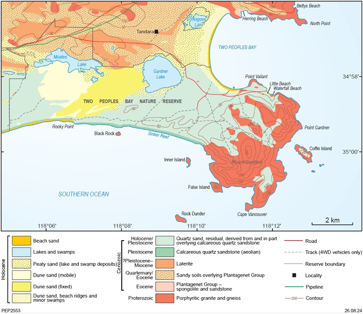
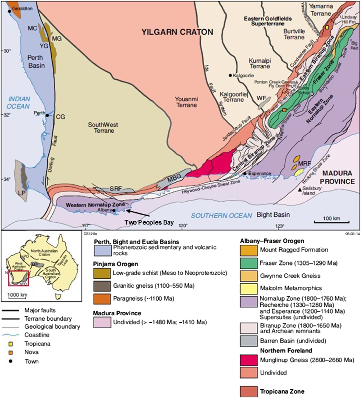
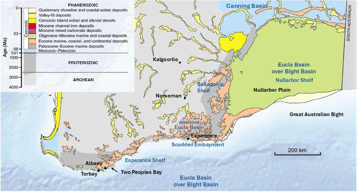
Two Peoples Bay Nature Reserve, Western Australia (Fig. 1), is dominated by Maardjitup Gurlin/Mount Gardner (Noongar names for landscape features, where known, follow Knapp et al. (2024). The areas of outcropping rock within the Reserve form part of the western ‘Albany’ segment of the Albany−Fraser Orogen (Fig. 2), a belt of Archean and Proterozoic igneous rocks and deformed, amphibolite to granulite facies (high-temperature; moderate to high pressure) metamorphic rocks and greenschist facies (low to moderate pressure; low to moderate temperature) Proterozoic sedimentary basins along the southern and south-eastern coast of Western Australia (Tyler and Hocking 2002; Spaggiari et al. 2015; Quentin de Gromard et al. 2017; Geological Survey of Western Australia 2022). The orogen is faulted against the Yilgarn Craton to the north but includes areas of Archean rocks as Yilgarn Craton basement remnants within it. It is overlain by sedimentary rocks of the Phanerozoic Canning Basin to the north-east, and by those of the Eucla Basin, which extend offshore to the south and east, under the Bight Basin. In Two Peoples Bay Nature Reserve and the surrounding area, Cenozoic rocks are part of the Esperance Shelf of the Eucla Basin (Fig. 3).
Geological map of Two Peoples Bay Nature Reserve and surrounding area, Western Australia, mapped and compiled by P. E. Playford in 1982−1984. Redrafted by the Geological Survey of Western Australia (GSWA), 2024.
Simplified, pre-Mesozoic interpreted bedrock geology of the Albany–Fraser Orogen and tectonic subdivisions of the Yilgarn Craton, showing location of Two Peoples Bay. SRF, Stirling Range Formation; MBG, Mount Barren Group; WF, Woodline Formation; MRF, Mount Ragged Formation; CG, Cardup Group; LP, Leeuwin Province; MC, Mullingarra Complex; MG, Moora Group; YG, Yandanooka Group. Inset: AFO, Albany–Fraser Orogen; MP, Musgrave Province; PO, Paterson Orogen; L, Leeuwin Province; N, Northampton Province. Figure taken from Spaggiari et al. (2014).
The Cenozoic Eucla Basin and its sub-basins along the south coast of Western Australia. Figure is taken from a map of the Cenozoic geology of Western Australia in Cockbain (2014).
Granitic intrusions into high-grade metamorphic rocks are exposed along the coast near Albany, including at Torbay, Albany, Maardjitup Gurlin/Mount Gardner, and Yilberup/Mount Manypeaks. A petrological study of these was carried out by N. C. N. Stephenson in a PhD thesis at The University of Western Australia (Stephenson 1972, 1973a, 1973b, 1974, 1977, 1979). The Mount Barker–Albany 1:250,000 series geological map sheet, which covers Two Peoples Bay Nature Reserve, was mapped by P. C. Muhling, A. T. Brakel, and J. S. Moncrieff of the Geological Survey of Western Australia (GSWA) in 1978 as part of GSWA’s 1st edition mapping program (Muhling and Brakel 1985). The geology of the Reserve was studied for this project by P. E. Playford during a visit to the area from 26 January to 1 February 1982, and the results are in Fig. 1, originally compiled in 1984 using 1:40,000 colour aerial photographs taken in 1981 for the ‘Australian Survey Office’ (the most recent aerial photography flown in 2020 and 2022 is currently available from Landgate − https://www.landgate.wa.gov.au/location-data-and-services/imagery/aerial-imagery/). Since that time, no further systematic geological mapping or sampling has been carried out in or around the Reserve, although J. S. Myers re-interpreted the regional geology of the Albany−Fraser Orogen and compiled the Albany and Esperance 1:1,000,000 series geological map sheets (Myers 1995a, 1995b).
Extensive new data acquisition has taken place under the Western Australian Government’s Exploration Incentive Scheme. Data acquisition over Two Peoples Bay Nature Reserve included regional airborne magnetic, radiometric and electromagnetic surveys, ground gravity surveys, and ASTER (Advanced Spaceborne Thermal Emission Reflection Radiometer) satellite imagery. Digital versions of the geology and geophysics and satellite imagery can be viewed on GeoVIEW.WA, GSWA’s interactive (GIS-based) online geological mapping system (https://www.dmp.wa.gov.au/GeoView-WA-Interactive-1467.aspx) and the data can be downloaded for free from the Data and Software Centre (https://www.dmp.wa.gov.au/Data-and-Software-Centre-1483.aspx).
Together with new geochronology, geochemistry, isotopic data, passive and active seismic surveys, and satellite imagery, these data have allowed further, more detailed, interpretation of the Albany−Fraser Orogen and its adjoining tectonic units, and of the Eucla Basin (Cockbain 2014; Spaggiari and Tyler 2014; Smithies et al. 2015a; Spaggiari et al. 2015, 2018; Kirkland et al. 2017; Quentin de Gromard et al. 2017; Sippl et al. 2017; Mory 2023).
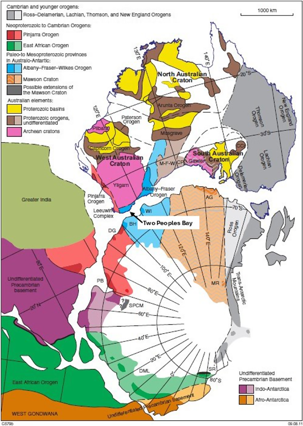
This paper describes the geology and landforms of Two Peoples Bay Nature Reserve and its surrounds, and places them into the context of the regional geological history over the past 1300 Ma (millions of years ago), particularly with regard to their plate tectonic setting as part of eastern Gondwana (Proterozoic Australia, Greater India, Antarctica; Fig. 4), which assembled within the supercontinent of Rodinia, and stayed together in Gondwana and Pangea, before the Australian plate started to break free from Greater India (165−120 Ma), and then from Antarctica (83−35 Ma). In the past 66 million years, during the Cenozoic, the development of landforms and shallow marine and surficial deposits record a history of tectonic uplift and sea-level change, and northward plate movement with climate variations from tropical climate into alternating periods of arid and humid climate associated with glacial and interglacial periods in the Pleistocene and Holocene.
Crustal elements of eastern-most Gondwana. Where paler and darker shades of the same colour are shown, the paler shade indicates large areas without outcrop where the crustal element is inferred. AG, Terre Adélie–King George V Land; BH, Bunger Hills; CCr, Curnamona Craton; CP, Coompana Province (concealed by the Officer and Eucla Basins); DG, Denman Glacier region; DML, Dronning Maud Land; M–F–W, Madura, Forrest, and Waigen Provinces (undivided; concealed by the Canning, Officer, and Eucla Basins); MR, Miller Range; PB, Prydz Bay; SPCM, southern Prince Charles Mountains; SR, Shackleton Range; WI, Windmill Islands. Figure taken from Quentin de Gromard et al. (2017), after Spaggiari et al. (2011), and references therein.
Geology of the Paleo- to Mesoproterozoic Albany−Fraser Orogen
The Albany−Fraser Orogen is made up of a series of zones, defined by major fault zones, which become younger away from the Archean Yilgarn Craton (Fig. 2; Spaggiari et al. 2015; Quentin de Gromard et al. 2017). The Northern Foreland, which includes the Archean 2800−2660 Ma Munglinup Gneiss, occurs to the south and south-east of the Jerdacuttup Fault, which defines the limit of structural and metamorphic reworking of the craton during the Proterozoic. The boundaries of the Biranup Zone (1800−1650 Ma), which includes further Archean remnants, and the Nornalup Zone (1800−1760 Ma) are defined by a series of crustal-scale shear zones. The Fraser Zone separates the Biranup and Nornalup zones in the north-eastern ‘Fraser’ part of the orogen. The outer edge of the orogen is marked by the Rodona Shear Zone, which is the limit of where reworking of the Archean crust can be traced from its isotopic signature and separates the orogen from the isotopically distinct Paleoproterozoic crust of the Madura Province (Kirkland et al. 2017). The Rodona Shear Zone marks the suture of the West Australian Craton against the Madura Province.
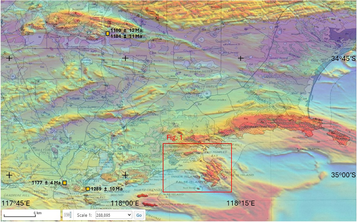
The Albany−Fraser Orogen has been affected by two major Mesoproterozoic tectonic events: (1) the Albany−Fraser Orogeny Stage I (1330−1260 Ma); and (2) the Albany−Fraser Orogeny Stage II (1200−1140 Ma) (Spaggiari et al. 2015; Quentin de Gromard et al. 2017; and references therein). Stage I represents the coming together of the West Australian Craton with the South Australian Craton and the Mawson Craton (Fig. 4), with crustal-scale thrusting well developed, together with high-temperature and moderate to high pressure metamorphism, pushing up the orogenic core onto the Yilgarn Craton margin (Spaggiari and Tyler 2014 and references therein). The foreland fold and thrust belt is preserved in the Stirling Range Formation and the Mount Barren Group, which are 1815−1600 Ma sedimentary rocks within the Barren Basin (Fig. 2). The Recherche Supersuite, consisting of coeval felsic and mafic magmatism, accompanied Albany−Fraser Orogeny Stage I. Stage II of the orogeny involved reactivation of the thrusts and shear zones, together with high temperature and moderate pressure metamorphism. The Stage II Esperance Supersuite magmas are predominantly intruded into the Nornalup Zone and are the manifestation of the Maralinga Event in the Albany−Fraser Orogen (Smithies et al. 2015a; Spaggiari et al. 2015; Kirkland et al. 2017). These intrusions can have distinctive, high magnetic geophysical signatures (Quentin de Gromard et al. 2017; Fig. 5).
An image made on GeoVIEW.WA (https://dmp.wa.gov.au/Geoview-WA-Interactive-1467.aspx) with part of the Mount Barker–Albany W.A. 1:250,000 Geological Series map (Muhling and Brakel 1985) overlain on a magnetic anomaly image of Western Australia produced by GSWA (http://www.dmp.wa.gov.au/Minerals/Regional-geophysical-survey-data-2274.aspx). The red box is the location of Fig. 1. The image shows the apparent coincidence of a magnetic anomaly (red) with the mapped outcrop of ~1180 Ma porphyritic monzogranite (mapped polygons of which have the label ‘Pgp’, and a pink base colour with red dot overprint pattern) around Two Peoples Bay, extending along the coast to Yilberup/Mount Manypeaks and Bald Island. The porphyritic monzogranite is also coincident with a magnetic high in the Porongurup Range to the north-west. The location of sample sites for geochronology are shown (Pidgeon 1990; Black et al. 1992).
Two Peoples Bay at the heart of east Gondwana
The tectonic history of the Albany−Fraser Orogen records the period of amalgamation and stabilisation of the Columbia−Nuna Supercontinent from 2200 to 1450 Ma, before its break-up and re-assembly into the Rodinian Supercontinent from 1400 to 900 Ma (Johnson 2013, 2021; Gorczyk et al. 2024). The West Australian Craton is an amalgamation of the Archean Yilgarn and Pilbara cratons along the intervening Proterozoic Capricorn Orogen during the assembly of Columbia−Nuna (Fig. 4). Along the West Australian Craton’s south-eastern edge, NW−SE-directed crustal extension prevailed from ~1800 Ma, reworking the Archean crust of the Yilgarn Craton as basement within the Albany−Fraser Orogen (Munglinup Gneiss on Fig. 2; Spaggiari et al. 2014; Smithies et al. 2015a). After 1600 Ma, this event first formed the Barren Basin, and then the succeeding Arid Basin (Spaggiari et al. 2015). A switch to convergence brought together the West Australian Craton (including the Albany−Fraser Orogen) with the combined South Australian Craton and the Mawson Craton, which forms the opposing part of the Antarctic continent to Australia, across the Southern Ocean (Fig. 4). Greater India was attached to Australia along the Pinjarra Orogen on Australia’s western coast, the eastern edge of which is marked by the Darling Fault.
The 1200−1140 Ma Maralinga Event, with very high crustal temperatures, was centred on the Musgrave Province in central Australia (Smithies et al. 2015b). It produced melting of the lower crust and the underlying mantle, generating large volumes of predominantly felsic magma that intruded into the upper crust across the Musgrave Province, and the Rudall Province, the Madura and Coompana provinces and the Albany−Fraser Orogen. This effectively cratonised that region and froze into place the craton configuration at that time. Subduction had started around 1415 Ma with the development of the Loongana arc and continued until ~1260 Ma, by which time ‘soft’ docking, rather than a full continent−continent collision between the West Australian Craton and the South Australian Craton (Gorczyk et al. 2024) had put the Albany−Fraser Orogen at the heart of eastern Gondwana (Fig. 4).
Mesoproterozoic metamorphic and igneous rocks in and around the Two Peoples Bay Nature Reserve
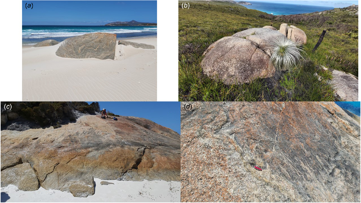
The oldest rocks exposed in Two Peoples Bay Nature Reserve and its surrounding area are within the western Nornalup Zone of the Albany−Fraser Orogen (Fig. 2). Deformed layered granitic orthogneiss have been mapped including coarse-grained microcline augen gneiss, fine- to medium-grained granoblastic-textured granitic gneiss, and quartz−feldspar−biotite(−garnet−hypersthene) gneiss (Fig. 6a) (Stephenson 1973a, 1973b; Muhling and Brakel 1985). The presence of hypersthene is indicative of high-grade, granulite facies metamorphic conditions, and amphibolite to mafic granulite layers are present.
(a) Outcrop (1.5 m high) of layered granitic gneiss on Normans Beach; Maardjitup Gurlin/Mount Gardner can be seen in the right background, across Two Peoples Bay. (b) Typical rounded tor-like outcrop of porphyritic monzogranite east of Yilberup/Mount Manypeaks, looking towards Mermaid Point. Potassium feldspar phenocrysts can be seen as rectangular, white patches in weathered rock surface. Grass tree is 2.0 m high. (c) Coastal outcrop at Little Beach of undeformed porphyritic monzogranite intruding deformed and metamorphosed, gneissic inclusions of country rock, people for scale. (d) Close up of contact between porphyritic monzogranite and layered gneiss; penknife is 9 cm in length (photographs IM Tyler).
Pidgeon (1990) obtained a U−Pb zircon age of 1289 ± 10 Ma from a sample referred to as ‘enderbitic gneiss’ that was collected near Middleton Beach, east of Mount Clarence in the town of Albany. The rock was described by Stephenson (1974) as a coarse-grained, dark green-grey, granoblastic, orthopyroxene-bearing granodiorite, and is therefore a charno-enderbite of the charnockitic series (Le Maitre et al. 2002). This sample is regarded as equivalent to the gneisses mapped around Two Peoples Bay Nature Reserve (Muhling and Brakel 1985), and the age is consistent with orthogneiss intruded as a granitic magma into granulite facies metamorphic conditions during the 1330−1260 Ma Albany−Fraser Orogeny Stage I.
Porphyritic monzogranite forms the Maardjitup Gurlin/Mount Gardner intrusion within the Reserve, which was referred to by Stephenson (1973a) as the ‘Mount Gardiner Adamellite’ (the granite rock name ‘adamellite’ is now obsolete, with the term ‘monzogranite’ preferred; Le Maitre et al. 2002). Muhling and Brakel (1985) did not adopt Stephenson’s name for the intrusion, or for its continuation along the coast, and its usage remains informal. The porphyritic monzogranite has abundant megacrysts of microcline in a groundmass of quartz, microcline, plagioclase (oligoclase/andesine), and biotite (Fig. 6b). The rock is generally homogeneous, without layering, but it does grade into foliated to gneissic zones, consistent with localised, post-intrusion shearing and local flattening. Minor micromonzogranite dykes up to several metres wide are present, locally with microcline megacrysts. Some minor pegmatite and quartz veins intrude the granite at several localities (Stephenson 1973a). The earlier gneisses occur as country rock xenoliths, well seen at the north-west end of Little Beach (Fig. 6c, d). Muhling and Brakel (1985; see also Stephenson 1973a) also noted wide zones along the intrusion margins they referred to as ‘migmatite’ where the gneisses are intruded by veins, dykes, patches, and lit-par-lit sheets of porphyritic monzogranite.
Pidgeon (1990) dated a sample of the related ‘Albany Adamellite’ taken from a quarry developed in biotite monzogranite with aligned K-felspar megacrysts (Stephenson 1972) on Mount Melville, west of Albany. A U−Pb zircon age of 1177 ± 4 Ma was obtained and is interpreted as the age of crystallisation of the zircon and is therefore the age of intrusion of the porphyritic monzogranite. Black et al. (1992) obtained similar ages (1180 ± 12 Ma; 1184 ± 11 Ma) from samples of the ‘late tectonic’ Porongurup granite (Fig. 5). This indicates that the granitic intrusions are members of the Esperance Supersuite, intruded during the 1200−1140 Ma Albany−Fraser Orogeny Stage II. There is a time gap of over 110 million years between the formation of the early, deformed and layered granitic gneisses and the later, intrusive porphyritic granite, which is consistent with the described intrusive margins to the intrusions and the presence of the gneisses as xenoliths in the porphyritic granite, rather than in situ melting in a single event as suggested by Stephenson (1973a).
From the aeromagnetic geophysical imagery (Fig. 5), the distinctly magnetic porphyritic granite intrusion can be interpreted as a series of linked bodies forming a discontinuous, sinuous sheet extending along the coast from Bald Island south of Cheynes Beach at least to Torbay, east of Denmark. The Porongurup granite is similarly magnetic (Fig. 5).
Geology and landforms of the Cenozoic Eucla Basin
The plate configuration in Fig. 4 remained stable for ~1.0 billion years until the break-up of Gondwana, which took place in the Mesozoic, starting in the Middle to Late Jurassic and continuing into the Early Cretaceous (see description and figures in Mory (2023)). Greater India rifted away from Australia and Antarctica from ~165 to 120 Ma, marked in south-western Australia by the eruption of the ~136 Ma Bunbury Basalt (Olierook et al. 2019). The separation of Australia from Antarctica began at ~83 Ma with the Southern Ocean opening from west to east, and separation of the two continents complete by ~35 Ma, at the start of the Oligocene (Cockbain 2014; Mory 2023). Rifting was initially guided by major east−west oriented faults, themselves following the Mesoproterozoic suture between the West Australian Craton and the Mawson Craton within the ‘Albany’ segment of the Albany−Fraser Orogen (Fig. 2). East of Esperance, the rift diverges from the north-easterly oriented ‘Fraser’ portion of the orogen, continuing eastward into the Great Australian Bight.
The following description of the evolution of the Cenozoic of the Eucla Basin is extracted from the summary of the last 100 million years of Western Australia’s geological history given by Cockbain (2014). Sedimentary rocks from the earliest Cenozoic (Paleocene to early Eocene; 66−50 Ma) are not present in the south-west of Western Australia and their absence is due to uplift related to Australia’s ongoing separation from Antarctica as its northwards drift accelerated, away from Antarctica. In the Eucla Basin in the middle to upper Eocene (50−34 Ma), the clastic-dominated Plantagenet Group was deposited on the western Esperance Shelf (Fig. 3), while in the east the Wilson Bluff Limestone was deposited on the carbonate-dominated Nullarbor Shelf above the basal Hampton Sandstone. In between, the Eundynie Group in the Norseman–Kalgoorlie area was deposited on the intervening Balladonia Shelf and the marine Scadden Embayment, grading north into fluvial deposits in a series of paleovalleys (Fig. 3). Cockbain (2014) described the basin as a simple epeiric ramp (i.e. developed on the continental margin) with an open arcuate coast in the east, but westward from Esperance forming a more complex, partly barred, and embayed archipelago.
The Plantagenet Group in the Two Peoples Bay area consists of the basal Werrilup Formation, and the overlying Pallinup Siltstone. It is poorly exposed, and inland from Two Peoples Bay itself is overlain by residual sandy soil, probable Oligocene to Miocene laterite, and by Holocene peaty sand, and swamp and lake deposits (Fig. 1). The Werrilup Formation is exposed above Herring Beach (Fig. 1), where it unconformably overlies Proterozoic monzogranite and is overlain by the Pallinup Siltstone. The contact with the granite is strongly irregular, with local relief of about 3 m, although the total relief in the vicinity is at least 30 m. The Werrilup Formation at Herring Bay consists of grey to dark brown, strongly cross-bedded, medium-grained quartz sandstone, which is partly siliceous or ferruginous. The thickness of the unit is 13.5 m. The Werrilup Formation is also exposed in road cuts on the road to Albany immediately west of the area mapped in Fig. 1.
Muhling and Brakel (1985) reported the age of the Werrilup Formation, based on foraminifers (Quilty 1969) and palynomorphs (Hos 1975), as late Eocene. The presence of the large foraminifer Asterocyclina sp., and the algae Neomeris sp., and Lavaria sp. indicated shallow, warm, marine conditions, while the sporadic occurrence of lignite and non-marine clays in the Plantagenet Group recorded localised deposition in coastal swamps. Cockbain (2014) pointed out that larger foraminifer fauna, together with bryozoans, such as those seen in the Nanarup Limestone Member, accompanied the middle to late Eocene ‘tropical’ or ‘warm temperate’ warming of the ‘Middle Eocene Climatic Optimum’ suggesting that the proto-Leeuwin Current may have reached this far south.
Pallinup Siltstone is well exposed also at Herring Bay, overlying the Werrilup Formation, and is overlain by laterized sandy soil. It is about 14 m thick, consisting of orange, yellow, and whitish bedded spongolite, which is clayey in part. It contains prominent silicified ‘stick’ sponges and some poorly preserved bivalves, echinoid spines, and bryozoans. Strong bioturbation is visible in some horizons. Pallinup Siltstone is also exposed in two dams near Tandara homestead, west of Miialyiin/Angove Lake (Fig. 1). Muhling and Brakel (1985) reported that nautiloids indicate a late Eocene age.
According to Muhling and Brakel (1985), Pallinup Siltstone was deposited in a shallow transgressive sea with a coastline along the southern Stirling Range. The transgression extended further westward, with the marine embayment continuing past the eastern end of the range. Chert horizons and spongolite (such as the Fitzgerald Member) are local examples of widespread silica production at that time, due to the warm humid climate resulting in enhanced weathering and runoff bringing more silica into the ocean (Cockbain 2014). Granite monadnocks such as Torbay Hill, Maardjitup Gurlin/Mount Gardner, and Yilberup/Mount Manypeaks, and other patches of high ground within the embayment, formed numerous islands (Muhling and Brakel 1985), with the Plantagenet Group deposited on the surrounding sea floor.
Around 23 Ma, in the early Miocene, the northward movement of Australia toward the subduction zones of Indonesia and south-east Asia resulted in plate collision (Hall et al. 2011). Along the southern margin of Western Australia, a dynamic topography response caused uplift and emergence to take place consistent with a continent-scale tilting after the Eocene, aligned southwest-up, northeast-down (Cockbain 2014, p. 24). Deposition of the Eucla Group limestones underlying the Nullarbor Plain and forming the upper part of the coastal cliffs along the Great Australian Bight, marked a transition from initially cool to later warmer conditions from middle Oligocene to the late Miocene, attributed to the continuing influence of the warm proto-Leeuwin Current from the west (Cockbain 2014). Deposition was on a broad epeiric ramp that extended to the Norseman–Kalgoorlie area, 450 km south to north. This marked the maximum Cenozoic transgression in Western Australia, at around 13 Ma (Cockbain 2014).
Cenozoic regolith landforms and landscape evolution in and around Two Peoples Bay Nature Reserve
During the Oligocene and Miocene, the western Esperance Shelf was emergent above sea level due to differential uplift produced by Australia’s tilt. In the area around Two Peoples Bay, laterite formed during deep weathering and is massive to pisolitic, sandy, and ferruginous. It is exposed principally in the north-eastern part of the mapped area (Fig. 1), overlying Proterozoic granite and sandy soils over the Plantagenet Group. This period of laterite formation is coincident with the warming climate of the ‘Miocene Climatic Optimum’.
With continued tilting extending into the eastern Eucla Basin, uplift raised the late Miocene sea floor to ~150 m to form the emergent Nullarbor Plain. In the western Esperance Shelf and Scadden Embayment, prominent late Eocene wave-cut benches are seen at 260−280 m around hills that would have formed islands, including Mount Ragged and Mount Barren (fig. 14 in Cockbain 2014).
At a smaller scale, the tilting of the Australian continent also produced an intermediate wavelength (~100 km) deformation. This is identified in the western part of the Eucla Basin where Eocene sediments lie at significantly lower elevations than equivalent sequences in the central Eucla Basin and in paleodrainages in the Norseman−Kalgoorlie region. This reflects down warping southwards from the east–west Jarrahwood Axis of the associated Ravensthorpe Ramp (fig. 29 in Cockbain (2014)). In the Two Peoples Bay area the effect is that the base of the Plantagenet Group, and the equivalent Eocene sea floor remained close to present sea level, as is seen at Herring Beach. Immediately inland of Two Peoples Bay, the upper lateritized surface of the Pallinup Formation is around 50 m above sea level and up to 100 m around granite outcrops (Fig. 1). This is the lower end of a slope identified by Muhling and Brakel (1985) that rises gently to the base of the Stirling Range (elevation ~200 m). It comprises residual white sand and laterite overlying the Plantagenet Group, on which lie numerous lakes and swamps. Monadnocks of fresh granite and gneiss include the Porongurup Range (up to 670 m). The local Kalgan River has incised into the surface (Fig. 5).
The late Pliocene and the Pleistocene were marked by alternating periods of aridity and humidity due to the cycles of glacial and interglacial periods. Since the Last Glacial Maximum at 21−19 ka (thousands of years ago), sea level has risen ~125 m to its present level (Lewis et al. 2013).
The middle and late Pleistocene Tamala Limestone (‘coastal limestone’) fringes the Western Australian coast from Shark Bay round to Esperance as lithified shoreline and dune sands, typically associated with inland swamp and lacustrine deposits, and by cave formation (Playford et al. 1976; Cockbain 2014).
In Two Peoples Bay Nature Reserve, calcareous quartz sandstone of Pleistocene to Holocene age outcrops prominently along the coast from Sinker Reef to west of Rocky Point (Figs 1 and 7a). It is an eolian deposit, strongly cross-bedded, and is interpreted here as the stratigraphic equivalent to the Tamala Limestone. The unit includes many root structures (rhizoliths) formed by calcification around roots of trees and shrubs that grew on the original dunes. Fossil land snails (Bothriembryon) are common in the sandstone.
(a) Sinker Reef, looking east to Maardjitup Gurlin/Mount Gardner (408 m) and False Island (see Fig. 1). An elevated, probably Holocene shoreline platform is about 3.5 m above the adjoining wave-washed, modern platform. The photographer is standing on the cliff above, which is composed of calcareous quartz sandstone, a lithified Pleistocene eolianite deposit equivalent stratigraphically to the Tamala Limestone. This represents the accumulation of sand shoals and dune sands that ‘tied’ Maardjitup Gurlin/Mount Gardner to the mainland during the Pleistocene and Holocene. (b) Kaiupgidjukgidj/Moates Lake, glimpsed through fringing vegetation in swampy peaty sands, has a large blow-out with mobile dunes to the south (see Fig. 1). Holocene parabolic sand dunes, previously stabilised by vegetation are present further to the south and east (photographs KA Evans).
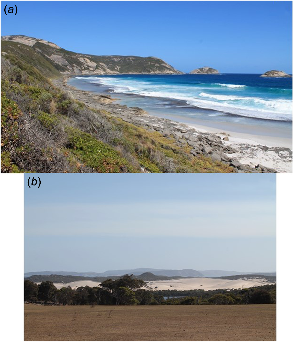
The maximum exposed thickness of the unit is about 60 m at the eastern end of the Sinker Reef cliff. Here the sandstone can be seen to abut a steeply sloping unconformity on the granite of Maardjitup Gurlin/Mount Gardner (Fig. 7a). The sandstone extends below sea level; therefore, its total thickness is unknown.
Residual quartz sand of late Pleistocene to Holocene age overlies the calcareous sandstone over a large part of the area west of Maardjitup Gurlin/Mount Gardner, extending along valleys in the granite to elevations of up to 200 m. The sand is interpreted to be a product of decalcification through weathering of the Pleistocene calcareous sandstone (W. M. McArthur, G. A. Bartle, K. A. Evans, I. M. Tyler, unpubl. data). Small patches of the original sandstone can still be seen in places below the sand (e.g. in the valley behind Waterfall Beach, Fig. 1).
Some laterite formation must also have taken place in the Pleistocene or Holocene, as it is present within the Pleistocene dune sandstones in the southwestern part of the Reserve (Fig. 1).
The Two Peoples Bay area is dominated by Maardjitup Gurlin/Mount Gardner, a mass of granite which rises to 408 m above sea level (Fig. 1). The granite coastline flanking the east, north, and south sides of Maardjitup Gurlin/Mount Gardner is very steep, with deeply incised streams descending to the sea. It shows elements of a drowned shoreline produced by sea level rise from melting ice over the 20 ka since the Last Glacial Maximum, with indentations on the coast controlled by the inundated stream valleys, and small offshore islands marking the crests of drowned hills. A similar coastal topography is found in the Djilliyiranup/North Point area, north of Two Peoples Bay.
The main granite mass around Maardjitup Gurlin/Mount Gardner is interpreted to have formed an island, and it was ‘tied’ to the mainland during the late Pleistocene and Holocene by the accumulation of sand shoals and dune sands, now largely lithified as calcareous sandstone.
The coastline west of the Maardjitup Gurlin/Mount Gardner granite mass is backed by cliffs up to 50 m high, composed of calcareous quartz sandstone, which is a lithified Pleistocene eolianite deposit regarded here as the stratigraphic equivalent to the Tamala Limestone. West of Rocky Point the cliff is fronted by a sandy beach, whereas at Sinker Reef there is little beach sand, and the cliff is fronted by an elevated shoreline platform that is about 3.5 m above the adjoining modern platform (Fig. 7a). The elevated platform is relatively little eroded and is presumably of Holocene age. Emergence of this platform is likely to be a result of ongoing tectonic uplift related to continental tilting, rather than a real drop in sea level. It is possible that the platform correlates with elevated platforms extending along the coast to the 2.4 m elevated platform at Rottnest Island, which emerged about 4.8 ka ago (Playford 1988).
Two Peoples Bay itself is bounded to the west by a wide beach, backed by beach ridges, dune sands, and some intervening swamps (Fig. 7b; W. M. McArthur, G. A. Bartle, K. A. Evans, I. M. Tyler, unpubl. data). Miialyiin/Angove, Tyiurrtmiirity/Gardner, and Kaiupgidjukgidj/Moates Lakes have been dammed behind late Pleistocene, Holocene and modern dunes. The lakes are fringed by peaty sands marking earlier extensions of the lakes and their associated swamps. Most of the Holocene sand dunes can be seen to be parabolic in form in aerial photography (viewed from the Landgate Aerial Imagery layer on GSWA’s GeoVIEW.WA) and are oriented consistent with a prevailing wind from the W-SW, along the coast (Hesp 2024). They are now stabilised by vegetation, but there is a large blow-out with mobile dunes south of Kaiupgidjukgidj/Moates Lake (Fig. 7b; W. M. McArthur, G. A. Bartle, K. A. Evans, I. M. Tyler, unpubl. data), and some coastal dunes are active near Rocky Point. Several Holocene deposits have been mapped as beach sand, beach ridges, mobile and fixed dune sand, and lake and swamp deposits. Most consist of calcareous quartz sands, except for some swamp and lake deposits, which are commonly peaty and non-calcareous.
The residual sands formed by leaching of the Pleistocene eolian calcareous quartz sandstones that overlie Proterozoic granite on the flanks of Maardjitup Gurlin/Mount Gardner are effective reservoirs for groundwater, feeding small permanent springs and seepages. Consequently, many of the creeks draining Maardjitup Gurlin/Mount Gardner flow throughout the year, although the rate of flow is generally very small during the summer. The presence of this permanent water, with consequent dense vegetation, is perhaps one of the reasons why the Djimaalap/noisy scrub-bird (Atrichornis clamosus) was able to survive in this small area.
Conclusion
The influence of plate tectonics on the geological evolution of an area is profound, from the origin and composition of the oldest rocks to the present landscape and the youngest surficial deposits. Plate movement controls tectonic setting, and the cycle of continental rifting, plate movement (‘drifting’) and plate collision produces apparent medium- to long-term sea level rises and falls, and climate change as the Australian Plate separates from India and Antarctica and collides with south-east Asia. Smaller time-scale sea level rise and fall can be produced by climate variation such as the glacial and interglacial periods in the Pleistocene and the Holocene.
Understanding the geological history of an area, not just the distribution of rock types and their composition, is essential to understanding landscape evolution and the natural history of the flora and fauna that inhabit it.
Conflicts of interest
Ian Tyler, Katy Evans, and Phillip Playford AM (died July 2017) have not conflicts of interest to declare.
Acknowledgements
This paper is published with the permission of the Executive Director of the Geological Survey of Western Australia (GSWA), including the use of figures previously published in GSWA reports and records, and with the approval of CSIRO Mineral Resources Research Director, Discovery. IMT and KAE thank Denis Saunders for the opportunity to update the original manuscript prepared by PEP to include the results of extensive research that has improved our understanding of the origin and geological evolution of the Albany−Fraser Orogen and the Eucla Basin over the past 40 years. We thank Klaus Gessner (GSWA), Sandra Occhipinti (CSIRO), and an anonymous reviewer for their reviews.
References
Black LP, Harris LB, Delor CP (1992) Reworking of Archaean and early Proterozoic components during a progressive, Middle Proterozoic tectonothermal event in the Albany Mobile Belt, Western Australia. Precambrian Research 59(1–2), 95-123.
| Crossref | Google Scholar |
Geological Survey of Western Australia (2022) 1:500 000 tectonic units of Western Australia, November 2022 update. Geological Survey of Western Australia, digital data layer. Compilers of geology: Martin DMcB, Johnson SP, Riganti A. Available at https://dasc.dmirs.wa.gov.au/
Gorczyk W, Aitken ARA, Tyler IM, Betts PG, Kohanpour F (2024) Plate tectonic limits on the assembly of cratonic Australia. Gondwana Research 132, 275-286.
| Crossref | Google Scholar |
Hall R, Cottam MA, Wilson MEJ (2011) The SE Asian gateway: history and tectonics of the Australia–Asia collision. Geological Society, London, Special Publications 355, 1-6.
| Crossref | Google Scholar |
Hesp PA (2024) Beach and coastal dune systems of Two Peoples Bay Nature Reserve, Western Australia. Pacific Conservation Biology 30, PC24080.
| Crossref | Google Scholar |
Hos D (1975) Preliminary investigation of the palynology of the Upper Eocene Werillup Formation, Western Australia. Journal of the Royal Society of Western Australia 58, 1-14.
| Google Scholar |
Kirkland CL, Smithies RH, Spaggiari C, Wingate MTD, Quentin de Gromard R, Clark C, Gardiner NJ, Belousova EA (2017) Proterozoic crustal evolution of the Eucla basement, Australia: implications for destruction of oceanic crust during emergence of Nuna. Lithos 278–281, 427-444.
| Crossref | Google Scholar |
Knapp L, Cummings D, Cummings S, Fielder PL, Hopper SD (2024) A Merningar Bardok family’s Noongar oral history of Two Peoples Bay Nature Reserve and surrounds. Pacific Conservation Biology 30, PC24018.
| Crossref | Google Scholar |
Lewis SE, Sloss CR, Murray-Wallace CV, Woodroffe CD, Smithers SG (2013) Post-glacial sea-level changes around the Australian margin: a review. Quaternary Science Reviews 74, 115-138.
| Crossref | Google Scholar |
Olierook HKH, Jiang Q, Jourdan F, Chiaradia M (2019) Greater Kerguelen large igneous province reveals no role for Kerguelen mantle plume in the continental breakup of eastern Gondwana. Earth and Planetary Science Letters 511, 244-255.
| Crossref | Google Scholar |
Pidgeon RT (1990) Timing of plutonism in the Proterozoic Albany Mobile Belt, southwestern Australia. Precambrian Research 47(3–4), 157-167.
| Crossref | Google Scholar |
Quilty PG (1969) Upper Eocene planktonic Foraminiferida from Albany, Western Australia. Journal of the Royal Society of Western Australia 52, 41-58.
| Google Scholar |
Sippl C, Brisbout LJ, Spaggiari CV, Gessner K, Tkalčić H, Kennett BLN, Murdie R (2017) Crustal structure of a Proterozoic craton boundary: East Albany-Fraser Orogen, Western Australia, imaged with passive seismic and gravity anomaly data. Precambrian Research 296, 78-92.
| Crossref | Google Scholar |
Smithies RH, Kirkland CL, Korhonen FJ, Aitken ARA, Howard HM, Maier WD, Wingate MTD, Quentin de Gromard R, Gessner K (2015b) The Mesoproterozoic thermal evolution of the Musgrave Province in central Australia – plume vs. the geological record. Gondwana Research 27(4), 1419-1429.
| Crossref | Google Scholar |
Spaggiari CV, Kirkland CL, Smithies RH, Wingate MTD, Belousova EA (2015) Transformation of an Archean craton margin during Proterozoic basin formation and magmatism: the Albany–Fraser Orogen, Western Australia. Precambrian Research 266, 440-466.
| Crossref | Google Scholar |
Spaggiari CV, Smithies RH, Kirkland CL, Wingate MTD, England RN, Lu Y-J (2018) Buried but preserved: the Proterozoic Arubiddy Ophiolite, Madura Province, Western Australia. Precambrian Research 317, 137-158.
| Crossref | Google Scholar |
Stephenson NCN (1973a) The petrology of the Mt Gardner Adamellite, near Albany, Western Australia. Journal of the Royal Society of Western Australia 56(4), 103-108.
| Google Scholar |
Stephenson NCN (1973b) The petrology of the Mt Manypeaks Adamellite and associated high-grade metamorphic rocks near Albany, Western Australia. Journal of the Geological Society of Australia 19(4), 413-439.
| Crossref | Google Scholar |
Stephenson NCN (1974) Petrology of the Albany and Torbay Adamellite Plutons, near Albany, Western Australia. Journal of the Geological Society of Australia 21(3), 219-246.
| Crossref | Google Scholar |
Stephenson NCN (1977) Coexisting hornblendes and biotites from Precambrian gneisses of the south coast of Western Australia. Lithos 10(1), 9-27.
| Crossref | Google Scholar |
Stephenson NCN (1979) Coexisting garnets and biotites from Precambrian gneisses of the south coast of Western Australia. Lithos 12(2), 73-87.
| Crossref | Google Scholar |


