
Meteorological drivers of the eastern Victorian Black Summer (2019–2020) fires
Graham Mills A * , Owen Salkin B , Matthew Fearon C , Sarah Harris D , Timothy Brown C and Hauss Reinbold C
A School of Earth, Atmosphere and Environment, Monash University, Clayton, Vic., Australia.
B Natural Systems Analytics, Noojee, Vic., Australia.
C Division of Atmospheric Sciences, Desert Research Institute, Reno, NV, USA.
D Fire and Emergency Management, Country Fire Authority, East Burwood, Vic., Australia.
Journal of Southern Hemisphere Earth Systems Science 72(2) 139-163 https://doi.org/10.1071/ES22011
Submitted: 30 March 2022 Accepted: 30 July 2022 Published: 8 September 2022
© 2022 The Author(s) (or their employer(s)). Published by CSIRO Publishing on behalf of BoM. This is an open access article distributed under the Creative Commons Attribution-NonCommercial-NoDerivatives 4.0 International License (CC BY-NC-ND)
Abstract
The spring and summer of 2019–2020 (Black Summer) saw the largest and most significant bushfire outbreak recorded in eastern Australia. In Victoria, the fires ran from mid-November through early autumn. In this paper, we use a high-spatial and temporal resolution 48-year fire weather re-analysis data set (VicClim5) to describe fire weather and vertical wind and stability profiles for five significant high Forest Fire Danger Index (FFDI) fire events and compare these with detailed fire reconstructions. A feature of several of these fires was very active overnight fire spread driven by topographically enhanced low-level jets and low fine fuel moisture content. The FFDI values on these nights were either the highest or near highest on record in the 48-year data set. We describe cases of lightning ignition, prefrontal fire spread and two cases of post-frontal fire spread – one into Mallacoota on the early morning of 31 December 2019 and the other a northward overnight run down the Buffalo Valley on 4–5 January 2020. On two of the days studied there were complex wind changes associated with the inland penetration of low-level south-easterly winds under the influence of locally generated pressure gradients. An elevated hot, dry mixed layer above these shallow layers also played an important role. On one occasion there is some evidence of possible mountain-wave modulation of surface wind flows. These events demonstrate a range of features of the fire weather and climate in eastern Victoria and the utility of VicClim5 in 3-dimensional climatological analyses.
Keywords: Black Summer bushfires, climatology of extremes, cold fronts, eastern Victorian fire weather, elevated mixed layers, low level jets, overnight fire spread, wind changes.
1. Introduction
The spring and summer of 2019–2020 (Black Summer) saw the largest and most significant bushfire outbreak recorded in eastern Australia. Major bushfires commenced in south-east Queensland and northern New South Wales (NSW) in September 2019 and did not end in southern Australia until early autumn 2020. Nationally there were 33 deaths, more than 3500 homes were destroyed in NSW, Victoria, Queensland and South Australia, and over 10 × 106 ha were burnt (Royal Commission into National Natural Disaster Arrangements 2020).
In Victoria this was the most challenging bushfire outbreak since Black Saturday 2009, and the greatest geographic spread since 1939 (Inspector General of Emergency Management 2020). Five lives were lost, 372 houses and much public infrastructure destroyed, and there were massive socioeconomic, environmental and personal costs.
The fires in eastern Victoria during Black Summer were largely ignited by lightning. Although these fires burnt for many weeks, they were particularly active on a reasonably small number of days. Salkin (2022) has reconstructed the spread of many of these fires and provides detail of the major fire runs. We examined the meteorological conditions associated with those runs, focussing not only on the surface parameters, but also on the vertical stability and wind profiles, and compared the three-dimensional evolution of the meteorological parameters with the reported evolution of these fires. Our analyses primarily utilised the 48-year hourly 4-km gridded Victorian Fire Weather Climatology Data Set (VicClim5) (Brown et al. 2016; Harris et al. 2019). This data set provides hourly time series of meteorological parameters in three dimensions over Victoria. It has been extensively verified against AWS data and shown to match both climatological and extreme values well (Brown et al. 2016; Harris et al. 2019; Mills et al. 2020).
We focussed on the antecedent conditions leading up to the Black Summer fires, the fire weather during five periods of marked fire activity and the context of these conditions within the fire weather variability during Black Summer, based on VicClim5. A particular feature of several of these events was a major overnight fire run, often with the worst fire weather (highest Forest Fire Danger Index, FFDI) of the day occurring overnight rather than in the more normal (afternoon) part of the diurnal cycle.
There are relatively few papers that examine the fire weather of eastern Victoria. This is in part due to its more benign fire weather climatology compared to western and central Victoria, and to the lower population densities that lead to less human and infrastructure loss in spite of the scale of some wildfires in the region. Buckley (1992) described a fire near Bemm River in East Gippsland on 14 October 1988 that was affected both by strong prefrontal winds and a late afternoon backing wind change. Bureau of Meteorology (2003) described aspects of the 2003 fires in eastern Victoria, and Mills (2005) described one of the blow-up days in that season. Engel et al. (2013) described the interactions of the Beechworth fire on Black Saturday 2009 with a nocturnal front and bore. Kepert et al. (2016) focussed on the role of downslope winds driving overnight fire spread of the Aberfeldy fire in 2014. Sharples et al. (2010) and Badlan et al. (2012) each described foehn effects in Gippsland that lead to abrupt changes in FFDI, although these studies are not associated with actual fires. The mountain effects described in the review by Sharples (2009) are also relevant to the mountainous regions of eastern Victoria.
A purpose of this paper is to better understand how evolving meteorology in the complex landscape of eastern Victoria can affect fire behaviour, providing potential benefits to fire agencies, particularly predictive services, firefighter and incident management training, and to prompt new directions for coupled fire–atmosphere modelling and other research. The paper is structured as follows. First, the events selected for discussion are listed and the data sets used are described. We then summarise the antecedent conditions leading into the Black Summer fire season, and discuss the conditions during our case studies in the context of the variability through the season. The detailed meteorological evolution during each of the individual events is then described, and unique or common factors are diagnosed to aid understanding and identify knowledge gaps. We finally summarise and discuss the key findings of these event descriptions.
2. Methodology
2.1. Overview of events
Salkin (2022) provides a comprehensive reconstruction of fire activity and spread over eastern Victoria for the Black Summer fire period, and the Australian Institute for Disaster Reduction (AIDR) summary of the season1 also emphasises several days when there was enhanced fire danger and fire activity through Black Summer. Although the fires in eastern Victoria burned for many weeks we will focus on a small number of fire events described in these reports. The events selected follow:
Lightning ignitions north of Bairnsdale on the evening of 21 November 2019.
Complex fire behaviour of the W Tree–Yalmy fire under relatively benign FFDI weather conditions on the afternoon of 25 November 2019.
First significant run of the Marthavale–Barmouth Spur fire overnight on 20–21 December 2019.
Fire runs that (separately) affected Clifton Creek, Sarsfield, Buchan, Corryong and Mallacoota overnight on 30–31 December 2019. As part of the description of these events we will also discuss the record highest hourly FFDI at Gelantipy at 02:00 hours AEDT on 31 December 2019.
A fire run to the north of the Great Dividing Range into the Buffalo Valley from late evening to early morning on 4–5 January 2020 – the ‘Abbeyard Fire’.
Fig. 1 shows the topography of eastern Victoria, place names used in our descriptions and arrows depicting the major fire runs during the periods discussed in this paper. Table 1 lists the start and end times of the fire runs depicted by the arrows, together with the length, duration and Rate of Spread (ROS) of each run. Note that the ignition time of these fires was often days earlier than the commencement of the run being discussed, and that the fires continued beyond the time corresponding to the end of the arrow.

|

|
On many of these days other fires were active, both in Victoria and in south-eastern NSW, and these fires continued to burn between these events, but we will restrict our analysis to those dates. On each of these days the Bureau of Meteorology (BOM) analysed a trough or dry cold front moving through eastern Victoria. The wind changes associated with these cold fronts, and other wind changes relevant to fire activity, will be discussed given their importance to fire behaviour and management (Cheney et al. 2001).
2.2. Data
The latest version of the Victorian Fire Weather Climatology Data Set (VicClim5, Brown et al. 2016; Harris et al. 2019), January 1972–June 2020, was our primary source of data, and provided hourly values of surface FFDI, temperature, relative humidity, wind speed and wind direction; vertical profiles of wind speed and direction, temperature and humidity; and daily Keetch–Byram Drought Index and Drought Factor, on a 4-km grid over Victoria.
VicClim5 was generated using the Weather Research Forecasting (WRF) Numerical Weather Prediction (NWP) model to dynamically downscale global reanalysis data over Victoria. The direct model output was then bias corrected based on cumulative density functions (CDFs) of model and AWS observation data, with corrections at observation sites then interpolated to the model grid using adaptive inverse distance weighting. Earlier versions of VicClim were described by Brown et al. (2016, ver. 3) and Harris et al. (2019, ver. 4). The changes and improvements to VicClim5 over Version 4 include the following:
Reanalysis period extended through June 2020.
A further 12 AWS stations used in bias correction and spatial grid interpolation, bringing the number of stations used to 84, and extending the AWS data period used to compute observation CDF to June 2020.
Modifications to temperature, relative humidity and wind speed CDF to reduce the influence of outlier AWS values. This improved temporal continuity in extreme events.
Previous studies (Brown et al. 2016; Harris et al. 2019; Mills et al. 2020) have shown that VicClim very closely replicates AWS data at AWS locations both climatologically and during individual events. However, AWS data tend to be located preferentially at lower (settled) elevations, or on the peaks of the ranges, but are sparse at middle elevations of the forested ranges where many fires occur. The use of gridded data allows us to calculate fire weather parameters at the location of fire events.
A number of diagnostic variables were calculated using the VicClim5 data:
FFDI was calculated following Noble et al. (1980).
The magnitude of the hourly vector difference in wind (Vector Wind Change, VWC, km h−2), used as an indicator of wind change strength (Mills et al. 2020).
The Continuous Haines Index (C-Haines, Mills and McCaw 2010).
Mixed layer depth (MLD) – the depth of the turbulent mixed boundary layer – was calculated using the surface virtual potential temperature with a 0.5-K positive perturbation following Fearon et al. (2015).
Transport Wind was calculated as the vector mean wind through the depth of the mixed layer.
Convective Available Potential Energy (CAPE) was calculated using the ‘Most-Unstable’ parcel in the boundary layer.2
Fine Fuel Moisture Content (FFMC, %) was calculated using the simple formula of Sharples and McRae (2011):

where α is a vegetation-dependent constant, T is temperature (°C) and RELH is relative humidity (%). We used an α value of 0.75 based on Slijepcevic et al. (2013) for moist eucalypt forest. The precise value of α is not critical as our analyses focus on values relative to the seasonal distribution rather than the true value of FFMC. In most cases we use the 24-h mean FFMC to a given time in order to integrate previous overnight FFMC with conditions up to the time being discussed.
3. Antecedent and seasonal conditions
3.1. Antecedent conditions
Fire weather in Victoria is strongly influenced by remote climate drivers (Harris and Lucas 2019). In the months preceding Black Summer the Australian climate was affected by a strongly positive Indian Ocean Dipole – the highest value since spring 1997 – and a persistent negative Southern Annular Mode (SAM) (Bureau of Meteorology 2020). The negative SAM was exacerbated by a rare sudden stratospheric warming event (Lim et al. 2021). These climate drivers resulted in extreme rainfall deficits over eastern Victoria in each of the 3-year (Fig. 2), 1-year and 1-month periods to the end of December 2019 (Bureau of Meteorology 2020). Rainfall for each of these periods over eastern Victoria was in the lowest decile, and in large areas the lowest on record. Below average rainfall in Victoria, especially throughout spring, leads to highly flammable fuels and has been linked to above average fire activity in summer (Harris et al. 2014). Burrows (2019) points to extreme drought being a consistent precursor to widespread campaign fire outbreaks both in Australia and overseas.

|
3.2. Intraseasonal variability
We chose a period from 15 November 2019 through 15 January 2020 that encompasses all our key fire activity dates to represent Black Summer in eastern Victoria. There were some rainfall events up to ~10 November 2019 and after 15 January 2020, although all fires were not fully under control until late February or early March. In this section we provide some seasonal context to the event studies to follow.
There were a number of heat wave events during Black Summer in Victoria when record temperatures were recorded. Extreme heat was experienced over most of the state on 21 November 2019 with 13 long term reporting stations exceeding their previous November maximum temperature record, several by more than 1°C, and at Point Hicks by an exceptional 4.4°C (Bureau of Meteorology 2019a, 2019b). On 20 December 2019, Bureau of Meteorology (2019c) lists 24 Victorian locations where new December maximum temperature records were set, with some stations exceeding their previous record by more than 2°C. Horsham reported a new maximum temperature record of 47.9°C, although this was not listed in Bureau of Meteorology (2019c). Very high temperatures were also experienced across both Victoria and southern NSW on 30 December 2019, with December maximum temperature records broken at (in the broad areas discussed in this paper) Albury, Hume Reservoir, Dartmouth Reservoir, Hunters Hill, Khancoban, Bairnsdale, East Sale, Orbost and Combienbar (Bureau of Meteorology 2019c).
VicClim5 time series of hourly values of FFDI, FFMC, C-Haines, CAPE, MLD and VWC – all indices relevant to fire danger and fire behaviour – are shown in Supplementary Fig. S1–S6 at the following locations through our 2-month Black Summer period (see Fig. 1 for locations, and Table 1 for more details regarding the fires):
Marthavale (21 November, overnight 20–21 December, overnight 30–31 December events).
W Tree (25 November 2019 event).
Banana Track (29 December ignition, overnight 30–31 December 2019 fire run to Mallacoota).
Gelantipy (record FFDI on 31 December).
Mount Burrowa (overnight run 30–31 December 2019 of Upper Murray–Walwa fire).
Abbeyard (overnight 4–5 January 2020 northward fire run).
The FFDI is significantly higher at the locations analysed on 21 November, 20 December, 30 December 2019 and 4 January 2020 compared with the full period of analysis (15 November 2019 to 15 January 2020) (Supplementary Fig. S1a–S6a). However, the highest FFDI values rarely exceed 30 – much lower than the >100 values observed in western and central Victoria in events such as Black Saturday 2009 (e.g. Engel et al. 2013) and on some days during Black Summer. However, these FFDI values are climatologically extreme – at each of those locations an FFDI of 30 is above the 99.9th percentile of all hourly values in the 48-year VicClim5 data set, and the values at Gelantipy (61) on 31 December 2019 and at Mount Burrowa (48) on 4 January 2020 are the highest hourly values at those points in the entire 48-year VicClim5 data set.
The amplitude of the C-Haines time series fluctuates through the 2-month period with values exceeding 12 (approaching the physical limit of the index) at each of these locations on the four major fire event days listed above, although there are other days on which this value is also approached or exceeded (Supplementary Fig. S1c–S6c). However, these peaks have longer durations than those of the FFDI. The last 2 weeks of December tend to show more sustained high values of C-Haines. How the phase of the C-Haines maxima relates to the phase of the FFDI maxima is explored in the individual case studies in the following section.
Mills and McCaw (2010) note that high values of C-Haines can be associated with deep mixed layers. The MLD time-series (Supplementary Fig. S1e–S6e) all show a very marked diurnal cycle, with the more inland locations showing higher mean daytime values than the more coastal locations, and this is particularly marked at Banana Track. There are a few days at each location when extremely deep mixed layers (>4500 m above ground level, AGL) are seen, and these days largely coincide with the 21 November, 20 December, 30 December and 4 January fire events. The fact that C-Haines does not show a similar diurnal behaviour but is a maximum on the same days as the deepest MLDs suggests that the high values of C-Haines when MLD is low indicates that the C-Haines is sampling an elevated mixed layer at these times. There are 3 successive days of extremely deep MLD at most locations leading up to the night of 30–31 December 2019 – a deep and widespread continental airmass had penetrated to the extreme south-east of the continent over this sustained period.
The FFMC time-series (Supplementary Fig. S1b–S6b) reflect the synoptic cycles of weather systems in south-east Australia, with a slow drying over several days followed by a sharp recovery. The lowest (driest) values for the season at Marthavale are seen on the nights of 21 November (lightning ignition) and 20 and 30 December 2019 (the two major overnight fire runs). At Mount Burrowa and at Banana Track, the lowest seasonal values occurred in the early morning hours of 31 December, whereas at Abbeyard the FFMC was the third lowest for the season on 4 January. These FFMC values are the 24-h lagged mean to the nominated time. This indicates that there were many hours of sustained high temperature and low relative humidity, including a lack of relative humidity recovery during the previous night, leading to these seasonally very low FFMC at the time of these major fire runs.
Thunderstorms were a feature of the summer and the majority of eastern Victorian fires were lightning ignited (Inspector General of Emergency Management 2020). Further, there were periods when pyrocumulonimbus developed and interacted with ongoing fires (Peterson et al. 2021), particularly on 30–31 December. The CAPE hourly time series (Supplementary Fig. S1d–S6d) show some common features – most locations have positive CAPE on 21 November 2019 (Marthavale and W Tree fire ignitions), and most locations show a period of 3–4 days with a positive CAPE value from 29–31 December 2019 when the Gelantipy–Suggan Buggan, the Upper Murray–Walwa and the Banana Track fires were ignited on 29 December, and when the Ovens complex fires were ignited on 31 December 2019.
The hourly values of VWC at each location (Supplementary Fig. S1f–S6f) show that amplitudes and frequencies of high values of VWC vary between locations. The BOM analysed a synoptic-scale dry cold front (cool change) through eastern Victoria on each of the fire event days we have selected, and the time-series show VWC maxima on these days at most of the locations selected, although there is some variability in amplitude depending on the time of day of frontal passage and the detailed structure of the individual cool changes. The VWC maxima are lowest at Mount Burrowa – Mills et al. (2020) showed that wind changes tend to be weaker in north-east Victoria than south of the Great Dividing Range – and are least frequent at Banana Track. The more elevated locations (e.g. Abbeyard, Gelantipy and W Tree) show a greater number of high values than the lower elevation sites. The climatologically higher wind speeds and the topographically induced wind changes that occur more frequently at these locations contribute to these increased frequencies.
4. Event studies
4.1. Marthavale–Barmouth Spur fire ignition 21 November 2019
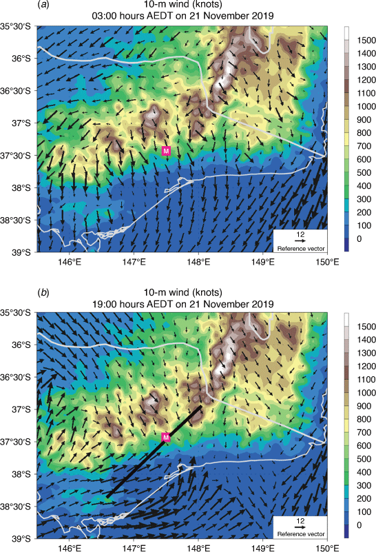
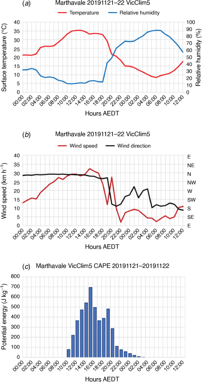
Fig. 3 shows the 10-m wind speed and direction across eastern Victoria at 03:00 and 19:00 hours AEDT on 21 November 2019, and Fig. 4 shows VicClim5 meteograms of hourly temperature, relative humidity, wind speed and direction, and CAPE from 00:00 hours AEDT on 21 November to 12:00 hours AEDT on 22 November 2019. At 03:00 hours AEDT on 21 November 2019, northerly winds were strengthening over Marthavale (Fig. 3a, 4b), the temperature was increasing and relative humidity decreasing (Fig. 4a) under downslope wind conditions, against the normal diurnal trend. This led to little overnight relative humidity recovery, and by mid-morning on 21 November the temperature was ~35°C and relative humidity remained ~10% through the day. Northerly winds fluctuated between 30 and 35 km h−1.
|
|
A cold-frontal wind change was approaching Marthavale at 19:00 hours AEDT (Fig. 3b). The front was surging along the Gippsland coast with post-frontal winds >50 km h−1, but the change was retarded inland by the ranges. The wind backed 140° between 19:00 and 20:00 hours AEDT (Fig. 4b) as the change moved through Marthavale. The wind speed dropped prior to the wind change but increased again to ~25 km h−1 for 1 h at 21:00 hours AEDT in the post-change south-westerly winds (Fig. 4b). The highest VWC at Marthavale on that day (37) was also the highest value there during the summer (Supplementary Fig. S1f).
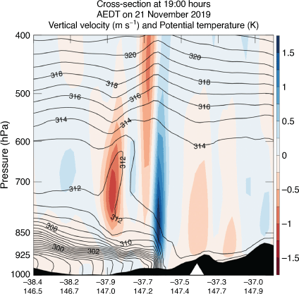
The time series of CAPE (Fig. 4c) shows conditionally unstable conditions at Marthavale from 10:00 hours AEDT on 21 November 2019 until after midnight, with the greatest instability in the 4 h before the wind change. The MLD at Marthavale was >4000 m AGL at 17:00 hours AEDT on 21 November 2019, and frontal convergence led to strong ascent just ahead of the wind change – see the south-west–north-east cross-section through the change at 19:00 hours AEDT on 21 November 2019 (Fig. 5). Reeder (1986) has shown that marked ascent ahead of a cold front as it moves into a deep mixed layer is a typical feature of the Victorian summertime dry cool change. Thus, two of the three ingredients (e.g. Doswell 1987) needed to generate thunderstorms – conditional instability and a lifting mechanism – were present here.
|
Following the weak relative humidity recovery in the early morning hours, the 24-h lagged mean FFMC (Supplementary Fig. S1b) on the evening of 21 November 2019 was only slightly less dry than the seasonal minima on 21 and 31 December 2019. Thus, on the evening of 21 November 2019 near Marthavale three conditions that contribute to a higher probability of a lightning ignition being sustained were present: much drier than normal fuels, an increase in wind speed following the wind change or lightning strikes and only low, or no, rainfall from these storms (Dowdy and Mills 2012).
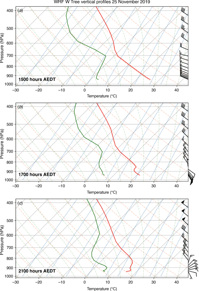
4.2. W Tree – 25–26 November 2019
Salkin (2022) describes changes in spotting behaviour and fire spread from the W Tree fire associated with complex wind changes during the afternoon and overnight on 25–26 November 2019. His description includes:
On the afternoon of the 25th at 1334 hrs the fire spotted across the Snowy River into inaccessible country. By 1538 hrs fire quickly grew driven by a westerly wind and an uphill run
and
By 1643 hrs the fire was travelling north and impacting on private property at Butchers Ridge.
The VicClim5 meteograms at W Tree (Fig. 6) show several wind changes during the 48-h from 00:00 hours AEDT on 25 November 2019. The BOM analysed a cool change moving across Victoria on 25 November 2019, and this is the change that passed W Tree between 07:00 and 08:00 hours AEDT on 26 November 2019 (Fig. 6c), with a VWC value above 40, one of the stronger changes there during Black Summer (Supplementary Fig. S2f). There are, however, two other changes earlier in that 48-h period and these have close relationships to Salkin’s descriptions of the changes in fire behaviour.

|
On 25 November 2019 the wind backed from north-north-east to westerly ~15 km h−1 between 08:00 and 10:00 hours AEDT with the onset of diurnal heating, and the mixed layer deepened to ~3000 m AGL by 15:00 hours AEDT (Fig. 6c, d). This marked the period where spotting to the east across the Snowy River was reported. During this period the FFDI was less than 15 although the C-Haines was above 10 (Fig. 6b) – in the upper (although not extreme) end of its distribution during that season (Supplementary Fig. S2c).
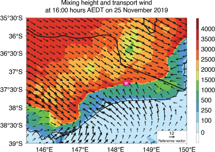
During the morning of 25 November 2019 a shallow layer of easterly winds developed near the Gippsland coast and slowly moved inland during the late morning and early afternoon, replacing the northerly winds. This wind change reached W Tree between 15:00 and 16:00 hours AEDT on 25 November 2019 (Fig. 6c), and the contrast between the shallow coastal (easterly) and deeper inland (northerly) airstreams is clearly seen at 16:00 hours AEDT in Fig. 7. The pressure gradients that drove the inland movement of this layer of south-easterly winds were likely generated by lowering pressures south of the ranges due to adiabatic warming of the descending north-westerly flow, the diurnally increasing land-sea heating contrast across the Gippsland coast and the development of an internal boundary layer over the ocean (Garratt 1986) in the synoptic scale north-westerly offshore flow. These easterly winds penetrated to near the crest of the ranges, reaching Omeo ~18:00 hours AEDT on 25 November, before stalling.
|
The change to south-easterly winds reduced the mixed layer depth to ~500 m (Fig. 6d), but above that layer there remained an elevated mixed layer with north-westerly winds extending to the same ~3000 m (Fig. 8a, b). After 18:00 hours AEDT, a very shallow radiation inversion resulted in the diagnosed MLD becoming very low (Fig. 6d); however, the vertical profile at 21:00 hours AEDT (Fig. 8c) shows the easterly wind layer above this, and above that the deeper well-mixed continental north-westerly air.
|
After 20:00 hours AEDT, the surface winds at W Tree shifted back to the north-north-east (the second wind change) and strengthened to above 20 km h−1 as the south-easterly layer was eroded by the deeper elevated mixed layer. With this change the temperature increased (relative humidity decreased), against the normal diurnal trend, and remained high (low) all night while the C-Haines remained high. Finally, between 07:00 and 08:00 hours AEDT on 26 November 2019 the synoptic-scale dry cool change passed W Tree bringing cooler and moister south-westerly winds.
Thus, the wind changes on the afternoon of 25 November described by Salkin (2022) were not associated with a dry cold front but were driven by diurnally varying topographic and land-sea heating contrast effects. These changes did, though, have marked effects on the reported fire behaviour, with the spotting to the east occurring prior to the south-easterly wind change in a deep mixed layer, whereas the south-easterly change drove the change in fire spread towards the north-west.
4.3. Marthavale–Barmouth Spur overnight fire run 20–21 December 2019
There was a major run of the Marthavale–Barmouth Spur fire overnight on 20–21 December 2019 (see Arrow 2 in Fig. 1). The fire crossed the Great Alpine Road north of Bruthen and, at 03:42 hours AEDT on 21 December, the Country Fire Authority issued a warning to residents of Ensay and surrounds that it was now too late to evacuate due to the active fire behaviour.3 More details are in Salkin (2022, fig. 51), shown as Supplementary Fig. S7.
At 02:00 hours AEDT on 21 December 2019, a cold frontal wind change was approaching Marthavale (Fig. 9a). Strengthening north-westerly winds had extended to the Gippsland coast ahead of the change and there was an area of enhanced FFDI with values of 30–40 over the region of the Marthavale–Barmouth Spur fire (Fig. 9b). This is not a period in the diurnal cycle when increased FFDI is necessarily expected.
|
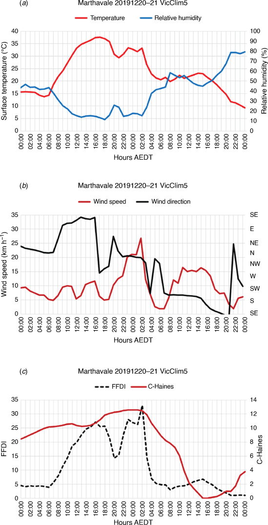
VicClim5 meteograms at Marthavale – the north-western end of the overnight fire run – for the 48 h from 00:00 h AEDT on 20 December are shown in Fig. 10. During the first 36 h there are a series of distinct wind changes with only the final change commencing at 02:00 hours AEDT on 21 December being the cold-frontal wind change seen approaching Marthavale in Fig. 9a. Salkin (2022) states that ‘the southwest wind change arrived at the fireground at 0250–0320’ (p. 50).
|
A wind change from northerly to east-south-easterly between 07:00 and 08:00 hours AEDT on 20 December 2019 marked the first change (Fig. 10b) as an easterly airstream moved inland under the influence of both adiabatic warming in the descending flow over the ranges and an increasing daytime land–sea temperature contrast. The temperature climbed to 37°C with a relative humidity minimum ~10% in the late afternoon of 20 December 2019 (Fig. 10a), indicating that in spite of the wind direction the air had a continental origin rather than being maritime air advected from Bass Strait. Wind speeds were ~10 km h−1, so peak FFDI during the afternoon was 27.
The convergence line between the inland north-westerlies and the coastal east-south-easterlies oscillated across the meteogram location between 16:00 and 22:00 hours AEDT on 20 December. Winds shifted back to northerly from 22:00 hours AEDT on 20 December 2019 until the frontal westerly change arrived at 02:00 hours AEDT on 21 December. This sequence of wind changes is similar to that seen in the W Tree case study of 25 November 2019 (Section 4.2).
The onset of northerlies after 22:00 hours AEDT brought an increase in temperature and decrease in relative humidity, against the normal diurnal trend, and just before the frontal wind change a sharp increase in wind speed to ~27 km h−1 (Fig. 10b) and FFDI to ~33 (Fig. 10c) at 02:00 hours AEDT on 21 December 2019 – a higher FFDI than was experienced during the previous afternoon. In addition to the high FFDI overnight prior to the wind change, there were also values of C-Haines > 12 (Fig. 10c) through the period of the major fire run from ~18:00 hours AEDT on 20 December 2019 until the frontal wind change between 02:00 and 03:00 hours AEDT on 21 December 2019. Prior to the wind change, the FFMC (24-h mean 5.9%) was also very close to the lowest value for the season (5.6%) recorded on 30 December 2019 (Supplementary Fig. S1b).
Defining ‘overnight’ as the period between 21:00 and 08:00 hours AEDT (inclusive), this was the second highest overnight FFDI at Marthavale for the season, and there are only four nights in the 48-year VicClim5 data set on which a higher FFDI occurred.
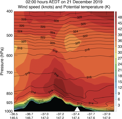
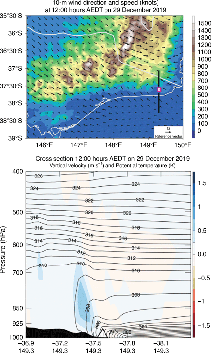
A north-west–south-east cross-section (Fig. 11) through Marthavale at 02:00 hours AEDT on 21 December and approximately aligned with both the pre-frontal north-westerly flow and the spread of the fire (Fig. 1, Arrow 2) shows the pattern of a blocking foehn (e.g. Sharples et al. 2010), with the isentropes descending on the lee side of the Great Dividing Range (cf. the increase in temperature between 20:00 and 22:00 hours AEDT in Fig. 10a), and strong low-level winds over the peak of the ranges and on the lee slope. These winds are part of the pre-frontal jet, but the isotach pattern suggests enhancement by downslope effects as part of the foehn circulation. At Marthavale and to its immediate south-east the wind speed is above 40 knots (~75 km h−1) very close to the surface, and just above a shallow stable surface layer. Any active fire would likely be able to interact with and be affected by this low-level jet (LLJ).
|
4.4. Events of 30–31 December 2019
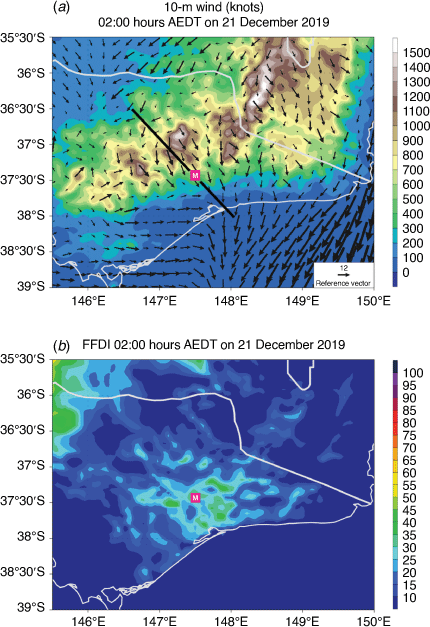
During this period over 500 000 ha were burnt in eastern Victoria. Overnight 30–31 December 2019, a dry cold front was moving through eastern Victoria. Fig. 12 shows the surface wind and the FFDI patterns at 23:00 hours AEDT on 30 December and 02:00 hours AEDT on 31 December 2019. At 23:00 hours AEDT the frontal wind change had passed Bairnsdale on the Gippsland coast and was just approaching Marthavale (Fig. 12a). To the north the change lagged well to the west, being blocked by the ranges east of Melbourne. Typically, the inland part of such a change becomes less sharp and advances more slowly north of the ranges under the influence of diabatic heating in the cool air west of the surface change (Deslandes et al. 1999; Reeder et al. 2000; Mills 2005). Ahead of the change, winds were generally north-westerly and speeds ranged from 15 to 25 knots (25–45 km h−1) across the mountains. The FFDI ahead of the change varied spatially but there were large areas exceeding 30 and occasionally 50, with an area above 50 immediately south-east of Marthavale (Fig. 12b).

|
By 02:00 hours AEDT the change had passed Marthavale and was approaching Gelantipy and Banana Track (Fig. 12c). There were still areas of FFDI above 30 in the north-east around Mount Burrowa and in the far east near Banana Track, but a marked increase in wind speeds in the Gelantipy area led to a large area with FFDI >50, and with some values above 100 (Fig. 12d). At Gelantipy, the VicClim5 FFDI of 61 at 02:00 hours AEDT (Supplementary Fig. S4a) was the highest hourly FFDI there in the 48-year VicClim5 data set. For verification, the highest hourly FFDI calculated from the full hourly AWS record at Gelantipy (1992–2020) was 76, also at 02:00 hours AEDT on 31 December 2019.
In the following sections we examine the detailed evolution of meteorological elements at Marthavale, Mount Burrowa and Banana Track, and relate them to the progression of these fires.
4.4.1. Tambo complex – Clifton Creek–Sarsfield fire run
There were many fire runs in the Tambo complex from the afternoon of 30 December through to the following morning, as well as others in eastern Victoria. A schematic of these is shown in Supplementary Fig. S8. Salkin (2022) states that one breakout (Fig. 1, Arrow 3) affected the towns of Sarsfield and Clifton Creek between 15:00 and 21:00 hours AEDT, whereas spotting from a separate fire run to the north was affecting Buchan ~19:00 hours AEDT on 30 December 2019.
The VicClim5 meteograms for 48 h from 00:00 hours AEDT on 30 December 2019 at Marthavale (Fig. 13) show two FFDI peaks >45 (Fig. 13a): the first in the mid-afternoon and a second at 22:00–23:00 hours AEDT on 30 December 2019. During the afternoon fire run the temperature was ~35°C, relative humidity ~10% and wind speed above 25 km h−1. In addition, the MLD was >4000 m AGL (Fig. 13c). These, combined with very low relative humidity (Fig. 13a), made conditions highly conducive to spotting.
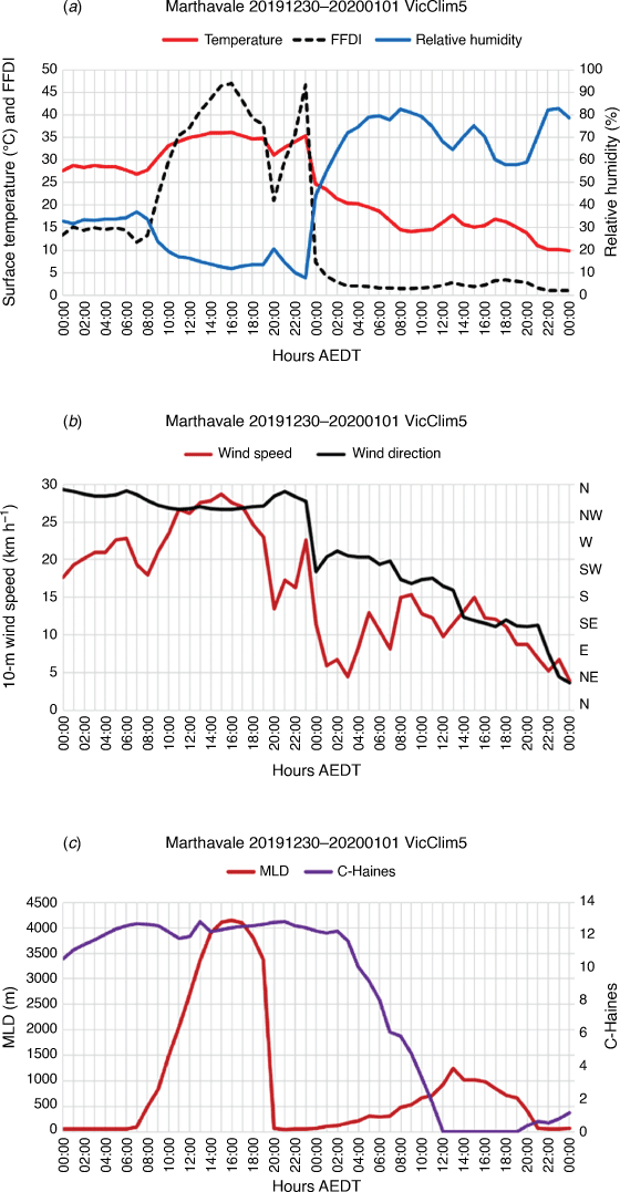
|
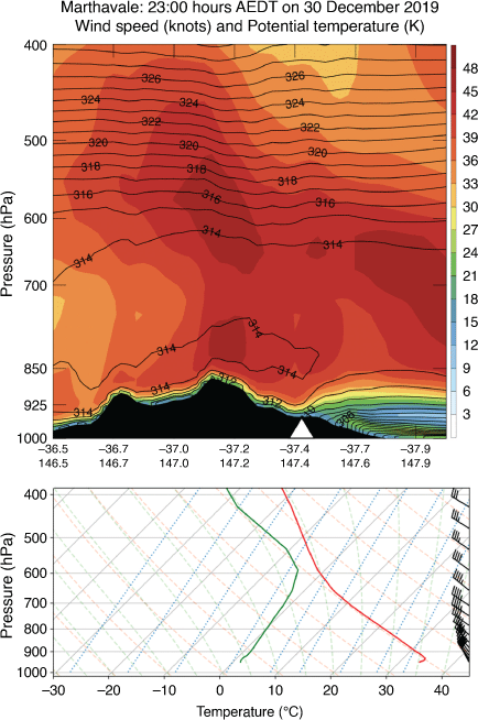
After 19:00 hours AEDT on 30 December 2019 a (likely weak) surface inversion formed, and the wind speed dropped until just before the south-westerly frontal wind change at 23:00 hours AEDT on 30 December 2019 (Fig. 13b). There was very little diurnal decrease in temperature (or increase in relative humidity) from the afternoon values before the frontal change, and the temperature rose to above 35°C and the relative humidity fell to below 8% at 23:00 hours AEDT on 30 December 2019 (Fig. 13a). These led to the secondary peak in FFDI at 23:00 hours AEDT on 30 December 2019. After 19:00 hours AEDT on 30 December 2019 the values of C-Haines > 12 persisted until after 03:00 hours AEDT on 31 December 2019 (some 2–3 h after the surface cold frontal wind change), indicating that the elevated mixed layer was still present even after the frontal wind change (Fig. 13c). The 24-h mean FFMC of 5.6% (Supplementary Fig. S1b) was the lowest at that location for the whole summer.
The vertical profile and a north-west–south-east oriented cross section through Marthavale at 23:00 hours AEDT on 30 December 2019 (Fig. 14) show this elevated mixed layer above a very weak surface inversion, and winds >35 knots (~65 km h−1) less than 1000 m AGL. The cool air marking the cold frontal layer was just south of Marthavale at this time. These strong north-westerly winds most likely show the presence of a pre-frontal LLJ, as they extend through the depth of the elevated mixed layer, though there appears to be some topographic enhancement near the crest and downstream of the Great Dividing Range. The strong north-westerly winds aloft, together with extraordinarily high temperature and low relative humidity, drove the rapid fire spread to the south-east.
|
The FFDI peaks in the afternoon (47.0) and overnight (46.6) were the second and third highest FFDI values that summer at Marthavale (Supplementary Fig. S1a), and only very slightly lower than the 49.5 of 4 January 2020, whereas 46.6 at 23:00 hours AEDT on 30 December 2019 is the highest overnight FFDI at this gridpoint in the 48-year hourly VicClim5 data set.
4.4.2. Upper Murray–Walwa fire
The Upper Murray–Walwa fire was ignited by lightning on 29 December 2019. On 30 December 2019 it spread rapidly south-east, generating a fire tornado that afternoon (Peace et al. 2021; Salkin 2022) and then burnt across Mount Burrowa to affect Cudgewa and Corryong early on 31 December 2019. The fire ran a remarkable 78 km between 16:15 hours AEDT on 30 December 2019 and 12:00 hours AEDT on the following day (Fig. 1, Table 1).
VicClim5 meteograms at Mount Burrowa show that the temperature peaked just below 35°C in the afternoon of 30 December (this is at a model elevation of 732 m) with relative humidity ~10% and FFDI at ~35 (Fig. 15a). Surface winds were from the north (Fig. 15b). After sunset the temperature dropped only slowly, remaining above 25°C with little relative humidity recovery throughout the night, and wind speeds remained ~20 km h−1. Thus, overnight FFDI values fluctuated between 20 and 30, averaging ~25. The wind change was more gradual here than south of the ranges so after sunrise on 31 December 2019 the wind backed steadily to the west, and temperature only rose to a little below 30°C as the northern part of the trough moved eastwards.
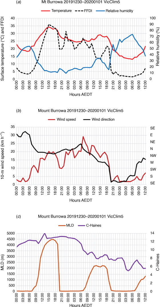
|
The MLD was >4000 m AGL in the late afternoon of 30 December 2019 (Fig. 15c). This dropped quickly after 19:00 hours AEDT on 30 December 2019 with the development of a surface inversion. However, a cross-section aligned north-west–south-east, approximately paralleling the above-surface wind, at 05:00 hours AEDT on 31 December 2019 (Fig. 16) shows that there remained an elevated mixed layer through the night, also indicated by the C-Haines remaining above 12 (the 96th percentile of all hourly values through the November–January period). Crucially, the cross-section also shows a strong LLJ, with wind speeds approaching 50 knots (~90 km h−1) just above a shallow surface inversion in the location of the fire-run down the eastern slopes of Mount Burrowa. This LLJ extends through to the north-west limit of the section, and so appears to be an example of a nocturnal LLJ developing once the boundary layer decouples from the surface (e.g. Markowski and Richardson 2010). Any fire with sufficient energy release to penetrate the surface inversion would interact with this hot, dry airmass and with the strong winds in the LLJ.
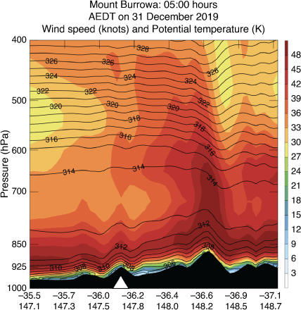
|
In the far south-east (right side of the section) we see strong downslope winds in the region of the Gelantipy nocturnal FFDI maximum (see Section 4.4) along with indications of mountain wave activity.
Peace et al. (2021) performed a coupled fire–atmosphere NWP model simulation of this fire and noted the deep dry mixed layer on that afternoon that enabled the generation of fire-induced vortices with considerable wind strength. They also noted the development of a nocturnal LLJ and marked interaction between this and the fire. Although those simulations are of much higher resolution (their inner domain has a 300-m grid spacing) than VicClim5, the LLJ and stability structure in VicClim5 are entirely consistent with this very high resolution coupled modelling. Note that the LLJ is present as a meteorological phenomenon and is not fire-induced. It is the interactions with this LLJ in the Peace et al. (2021) simulations that are fire induced.
The overnight maximum FFDI of 31.5 at 21:00 hours AEDT on 30 December 2019 at Mount Burrowa was by far the highest overnight FFDI there for that summer, and only on four other nights in the 48-year VicClim5 climatology data set did a higher FFDI occur. Not only were the conditions earlier in the day highly conducive to fire spread, but overnight conditions were, in addition to being anomalously warm and dry, also anomalously windy.
4.4.3. Banana Track – the run to Mallacoota
The ignition of this fire in the early afternoon of 29 December 2019 was attributed to lightning (Salkin 2022), and overnight on 30–31 December it ran rapidly eastwards to Mallacoota. VicClim5 meteograms from 12:00 hours AEDT on 29 December 2019 through 00:00 hours AEDT on 1 January 2020 are shown in Fig. 17. Positive CAPE is seen on the afternoon of 29 December (Fig. 17b). Fig. 18 shows the 10-m wind field at 12:00 hours AEDT on 29 December, together with a north–south cross-section through Banana Track. There is convergence between inland northerlies embedded in a deep mixed layer and coastal east-south-easterly winds (Fig. 18a). The thermal gradient at this airmass boundary (note that the BOM synoptic analysis shows the cold front in western Victoria at this time) gives rise to ascent above the convergence line (Fig. 18b). Thus, the necessary ingredients for thunderstorm generation – conditional instability and lifting – were present. If storms did occur, then the additional ingredients for sustaining a lightning ignition – a low (~11%) FFMC (Supplementary Fig. S3b) and at least moderate and sustained wind speeds (Fig. 17c) – were also present.

|
|
There were other periods during the fire run when pyrocumulonimbus developed over the fire (Peterson et al. 2021; Salkin 2022), and the CAPE time series (Fig. 17b) shows conditional instability on both the afternoons of 30 and 31 December 2019.
Reconstructions of the fire spread are shown in Salkin (2022, fig. 164, 165). VicClim5 meteograms from 12:00 hours AEDT on 29 December 2019 through 00:00 hours AEDT on 1 January 2020 are given in Fig. 17. The colour bars in Fig. 17c approximately match the colours of the fire boundaries in the reconstruction of Salkin (2022, fig. 164; reproduced as Supplementary Fig. S9). After ignition the fire initially ran to the west-north-west before backing winds drove a run to the south-south-west, and the fire reached the coast by 02:00 hours AEDT on 30 December 2019. Thereafter there was movement to the east under varying, but generally north-westerly, winds during 30 December 2019 before a rapid run to the north-east following a frontal wind change in the early hours of 31 December 2019. It was this run that affected Mallacoota from ~08:00 hours AEDT on 31 December 2019. The relation between the transitions in the reconstructed fire spread and the shifts in wind direction in the meteograms is clear, with the blue and orange bars showing the run to the coast under north-north-easterly winds, the brown bar the spread to the south-east as the winds shifted north-westerly and the yellow bar more rapid spread under strengthening north-westerly winds around the middle of the day on 30 December 2019. The green bar includes both the pre-frontal period of enhanced northerly winds and the strong surge in post-frontal south-westerly winds.
The 24-h mean FFMC values (<7%) were the lowest for the season at this location (Supplementary Fig. S3b) late on 30 and early on 31 December 2019. The highest afternoon FFDI was just over 40, and there was an overnight peak of 32 at 01:00 hours AEDT on 31 December 2019 just before the frontal wind change. The MLD (Fig. 17d) on the afternoon of 30 December 2019 was above 4500 m AGL (one of only 2 days in the season when the MLD exceeded 4000 m at Banana Track, see Supplementary Fig. S3e). Although the MLD dropped with the development of a surface inversion after 18:00 hours AEDT, the C-Haines was >12 and only began to fall some 2 h after the frontal change passed (Fig. 17d). After the cold frontal change wind speeds maintained ~15 km h−1 until well into the afternoon of 31 December 2019, driving the fire into Mallacoota.
The frontal change was quite shallow at Banana Track for some hours after the change passed. The vertical profile at 03:00 hours AEDT on 31 December 2019 (Fig. 19) shows the south-westerly winds and cooler air confined below 900 hPa; above this there is an elevated mixed layer of hot, dry air and a pre-frontal jet above 50 knots (90 km h−1). Whether this affected or interacted with the fire run to Mallacoota is an interesting subject for investigation.
|
The maximum overnight FFDI of 32.3 at 01:00 hours AEDT on 31 December 2019 was the highest overnight value for the Black Summer season, with overnight FFDI values at this point only exceeding 10 on one other occasion during the summer. There are only 2 h in the VicClim5 48-year climatology when the overnight FFDI at Banana Track exceeded 25, and these both occurred on this night of 30–31 December 2019.
4.5. The Abbeyard Fire – 4 January 2020
Fire activity was again widespread across East Gippsland and the Alpine areas on 4 January 2020 (Salkin 2022; AIDR). Salkin (2022, fig. 148), reproduced in Supplementary Fig. S10, shows that most of the fire runs in the Ovens and Tambo fire complexes that day were to the south-east, and occurred from mid-late morning to late afternoon (yellow arrows in Supplementary Fig. S10). Notably different is the late evening through overnight run of the Abbeyard fire to the north-north-west down the Buffalo Valley (red arrow in Supplementary Fig. S10, and Fig. 1, Arrow 6). We will focus on the conditions before and during this northward fire run.
As with other major fire weather days through this summer there was a marked frontal wind change moving through Gippsland, and at each location in Supplementary Fig. S1–S6 the VWC indicates that this change was one of the strongest in Black Summer. In addition the FFDI on 4 January 2020 was the highest or second highest for the season at these points.
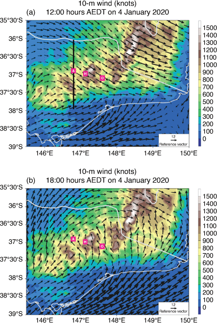
The surface wind pattern at 12:00 hours AEDT on 4 January 2020 (Fig. 20a) shows the frontal wind change along the coast of Gippsland and approaching the southern slopes of the Great Dividing Range. The fire runs to the south-east in Supplementary Fig. S10 were under these pre-frontal conditions. In the north, the change was approaching north-east Victoria, but with a more gradual backing of the wind. By 18:00 hours AEDT on 4 January 2020 (Fig. 20b) the change had moved to be almost completely east of Victoria, with strong southerly winds through the Omeo valley, south-easterly winds approaching Abbeyard and strong post-frontal south-westerly winds along the coast.
|
The cold-frontal wind changes on 21 November, 20–21 December and 30–31 December 2019 occurred overnight. However, on 4 January 2020 the frontal wind change was much earlier in the day, passing Bairnsdale just after 10:00 hours AEDT, Mallacoota just after 16:00 hours AEDT and Omeo between 14:00 and 16:00 hours AEDT.
At Bairnsdale the pressure rose more than 12 hPa in the 9 h after the frontal change – one of the strongest pressure-rises for the summer. With little pressure change to the north of the Great Dividing Range, this led to a >11-hPa Bairnsdale–Albury mean-sea-level pressure difference at ~21:00 hours AEDT on 4 January 2020, the highest such value that summer. The strong pressure rises indicate a deep layer of post-frontal cool air that drove the very strong post-frontal south-westerly winds (Fig. 20) along coastal East Gippsland after 12:00 hours AEDT (mean speeds above 40 km h−1 at Bairnsdale AWS), and a rapid penetration of the change northward and across the ranges at middle elevation inland sites. The FFDI values in Victoria were generally highest in the north-westerly flows just ahead of the frontal change, with values into the Severe (FFDI 50–75) range in areas of eastern Victoria; these values were confined to the far east and north-east by 17:00 hours AEDT on 4 January 2020.
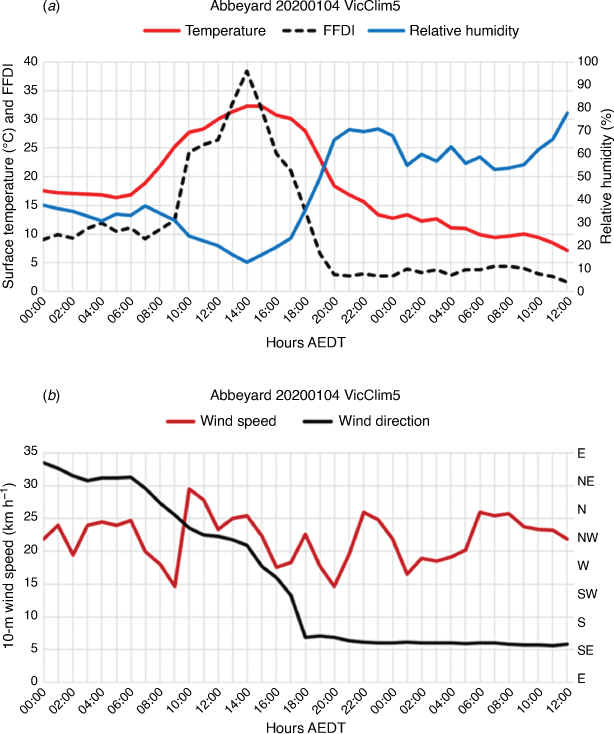
At the location of the Abbeyard fire, the temperature reached ~32°C in the early afternoon of 4 January 2020, with relative humidity ~15% (Fig. 21a). The temperature started to fall (relative humidity to rise) after 14:00 hours AEDT, with an increase in the rate of change after 17:00 hours AEDT. The highest FFDI (38) was at 14:00 hours AEDT (Fig. 21a). The wind backed from north-east around dawn to west-north-west ~14:00 hours AEDT, and then backed more rapidly to be south-easterly by 18:00 hours AEDT (Fig. 21b). Wind speeds fluctuated between 15 and 30 km h−1 ahead of and during the change, and between 15 and 25 km h−1 throughout the night in post-change south-easterlies.
|
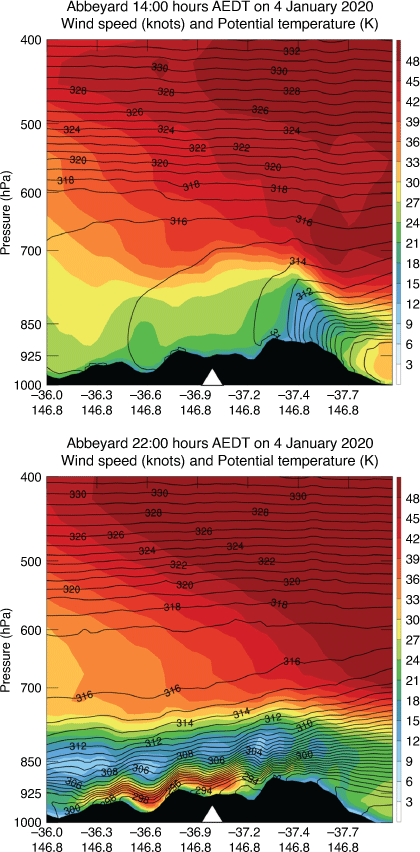
At 14:00 hours AEDT on 4 January (the time of maximum FFDI), a north-south cross-section centred on Abbeyard (Fig. 22a) shows a surface mixed layer to ~2700 m AGL. The cold front approaching from the south can be seen to the right of the section. By 22:00 hours AEDT (Fig. 22b) the front had crossed the Great Dividing Range and a strong LLJ had developed in the southerly downslope flow, with speeds just a few 100 m above the surface approaching 40 knots (~75–80 km h−1). Indeed Fig. 22b shows in some areas these winds reach to the ground on the slopes north of Abbeyard.
|
This LLJ sustained the overnight surface winds and, although strong near-surface stability reduced their magnitude at the modelled 10-m level, it is highly likely that heat release from the fire would have allowed the fire to interact with these stronger winds aloft, driving its spread down the Buffalo River valley.
5. Discussion
We described the meteorology around a number of fire activity and lightning ignition events during Black Summer. There are a number of features common to these events, as well as some unique to a single event.
A common feature was a synoptic-scale dry cool change moving through eastern Victoria. A LLJ was diagnosed ahead of the wind change in most of these cases, and although frontal dynamics would likely be the primary driver of these, the topographically induced temperature gradients around the sloping topography may also have contributed (e.g. Sharples 2009). There are some events where downslope effects are also evident (Marthavale on 21 December, Mount Burrowa on 30–31 December and Abbeyard on 4–5 January), and on one occasion we showed some evidence of possible mountain-wave modulation of surface wind flows (Gelantipy on 31 December). The interaction between the LLJs and these topographic modulations plays a crucial role in influencing fire behaviour.
The structure and timing of the changes is important. Diurnal variations in low-level stability lead to the interactions of the LLJ with the topography differing depending on the time of day of the frontal passage. Most of the events showed a peak FFDI associated with the pre-frontal jet, but on two occasions post-frontal wind surges had major effects on fire behaviour, driving the Banana Track fire into Mallacoota (31 December 2019) and the Abbeyard fire northwards down the Buffalo Valley (4–5 January 2020) (there were also a number of other post-frontal fire runs early on 31 December 2019, see the yellow arrows in Supplementary Fig. S8). Both these fire runs occurred overnight. Most of the cold-frontal changes in our cases examined were relatively shallow, and so penetrated northwards only slowly as the cool air deepened and could reach higher elevations. However, the 4 January 2020 event was much deeper, and so the cool air moved readily northwards up the valleys. This then led to funnelling though the lower parts of the Great Dividing Range, and overnight downslope winds in the Buffalo River valley that drove the Abbeyard fire.
The highest FFDI values during these events were generally during the afternoon (as is typical) and associated with deep mixed layers, whereas many of the overnight fire runs were associated with shallow stable surface layers, although still with a deep elevated mixed layer. It is likely that the heat release from these fires would have been sufficient to allow the fire to interact with these hot, dry, elevated mixed layers, particularly if the fire was at several 100-m elevation (Marthavale, Abbeyard, Mount Burrowa). Peace et al. (2021) has modelled such interactions in simulations of the Upper Murray (Mount Burrowa) fire.
Monitoring these elevated mixed layers is likely important in incident management, particularly around elevated terrain where a number of different physical drivers can cause a low-level inversion. In this paper we have seen examples of three of these mechanisms. The first is the simple radiation inversion, which can be quite shallow and weak, particularly in the early part of the evening. The second is that of a frontal inversion, with the depth of the cool post-frontal air increasing more or less rapidly with distance (time) after frontal passage depending on the structure of the individual cool change. The cool change at Banana Track on 31 December (Fig. 19) was a case of an initially relatively shallow change, and Cunningham (2007) has shown in a modelling study how such a shallow frontal inversion is not a solid barrier, and that turbulent entrainment across the interface layer occurs even without any interactions with heat release from a fire. There are clear implications for fire behaviour to be influenced not simply by the post-frontal surface meteorology, but for fire–atmosphere interaction to enhance the influence of this upper layer.
A third type of low-level inversion seen in these analyses (25 November, 20 December and 29 December 2019) is a consequence of Gippsland physiography. Under northerly synoptic flow an onshore pressure gradient can develop under the influence of enhanced daytime land–sea heating contrasts and the pressure falls caused by adiabatic warming of air descending south of the Great Dividing Range. This can lead to the northerly synoptic flow being replaced by an east-south-east flow several 100 m deep over the plains, but becoming shallower as it moves inland and the surface elevation rises. This can produce an abrupt change in surface winds as this easterly airstream moves inland against the topographic barrier. Above this layer there remains an elevated mixed layer, and so on the inland side a daytime ‘thermal belt’ (Sharples 2009) exists just above the intersection of the easterly air layer with the rising topography. From evening the low-level layer can erode, with winds shifting back to northerly and temperatures rising (relative humidity falling) against the normal diurnal trend. A synoptic-scale cold-frontal wind change can follow.
Thus, several abrupt wind changes can occur at a given location on these days, and such events are likely several times per year. Incident controllers and fire weather meteorologists should be aware of this feature of eastern Victorian meteorology. A more systematic study of these events to quantify their frequency and better understand their drivers would be interesting and likely valuable.
Although this conceptual model is based on eastern Victorian events, the physical ingredients of direction of the synoptic wind flow, the orientation of the topographic barrier and the orientation and distance from the topographic barrier of a coastline would also generate complex wind changes in other regions. Wilke et al. (2022) point to complex variations in wind speed and direction at AWS locations on the southern NSW coast during Black Summer, and Mills (2007) also documents interactions between synoptic-scale cold fronts and the topography in south-east NSW leading to geographically varying wind change behaviour.
In all three examples described above, the low-level inversions are overlaid by an elevated mixed layer that through fire–atmosphere coupling may influence fire behaviour in a way not represented by the surface meteorology. Although the algorithm used in this paper to diagnose MLD does not indicate an elevated mixed layer other than indirectly, we noted that the time-series of C-Haines may assist here. Whereas the peaks in FFDI in the 2-monthly hourly time-series (Supplementary Fig. S1–S6) were sharp, the C-Haines had longer maxima and extended beyond the peak of the FFDI, and often well into the evening and overnight after the surface-based MLD had ‘shut down’ due to the development of a shallow surface inversion. In these cases, the C-Haines was sampling the elevated mixed layer and thus indicated that such a layer exists. Mills and McCaw (2010) presented cases where C-Haines was high when overnight fire activity occurred in elevated terrain.
Although our estimates of FFMC use a very simple algorithm, the intra-seasonal variation provides a good indication of when conditions are drier than normal and such a routine monitoring would provide additional warning of conditions conducive to lightning ignitions (given lightning occurrence) or more active fire behaviour. If a climatology of these simple FFMC measures was to be available, the conditions in any given season could be interpreted in the context of the local climatology. Matthews (2013) stated that this algorithm provides sound estimates so long as an appropriate tuning factor (α) can be determined. There is potential for this to be estimated from landscape-wide vegetation classifications (T. Duff, pers. comm.).
6. Conclusions
In this study we looked at several days during Black Summer on which major fire activity was reported in eastern Victoria, and focussed on one lightning ignition event and five events where significant overnight fire runs were experienced. Of these five, four were over elevated terrain. In addition, we examined one daytime event where complex changes in fire weather and fire behaviour were experienced, in spite of relatively low values of FFDI. We used the VicClim5 fire weather climatology data set in the meteorological analysis as its hourly time resolution and 4-km grid allowed spatial and temporal variations of individual weather elements to be analysed in areas devoid of AWS observations, and for the first time this study used the vertical dimension of this data set to diagnose stability and vertical wind profiles. Its homogeneity over a 48-year period also allows the climatological context of these events to be analysed. The data from VicClim5 are compared with the detailed fire reconstructions for these events of Salkin (2022), and these comparisons provide convincing validation of the VicClim5 diagnoses in situations where no direct (AWS) validation is available.
Examining the hourly time-series of FFDI, FFMC, C-Haines, MLD, VWC and CAPE through the 2 months from 15 November 2019 through 15 January 2020 shows that the event-days studied generally had the highest FFDI and the lowest FFMC values of the season, were associated with C-Haines values near the upper range of its distribution, had deep mixed layers during the daytime hours and were associated with a strong wind change (or changes). In addition, the relatively rare positive CAPE periods generally coincided with lightning ignitions (Salkin 2022) or pyrocumulonimbus outbreaks (Peterson et al. 2021).
For each of these events, the highest daily FFDI at the locations of the fires was in the highest 99.9th percentile of all hourly values in the 1972–2020 VicClim5 data set. In addition, of the five overnight fire events, the overnight FFDI was the highest overnight FFDI in the 48-year VicClim5 data for three of the events, and in the highest five overnight FFDI values for the other two events. This is a remarkable statistic and is made even more striking given the highest ever FFDI hourly value (61 from VicClim5 and 76 from the AWS) at Gelantipy was recorded at 02:00 hours AEDT on 31 December 2019 – not during the commonly expected late afternoon diurnal peak in FFDI. These statistics emphasise the extraordinary climate anomalies of this season. There is clearly potential to further explore possible trends and variability in frequencies of high overnight FFDI values in the elevated regions of eastern Victoria. We note that Balch et al. (2022) associate some recent overnight fire runs with more frequent large values of overnight vapour pressure deficit in recent years.
The VicClim5 data set used for this study is not a forecast tool – it is a climatology. The data set provided considerable insights into features that can be resolved with operational NWP models (which have higher resolution) and which ultimately may benefit operational fire management decisions. The insights into eastern Victorian fire weather paradigms provided by vertical stability and wind profiles from VicClim5 suggest that there are opportunities for a range of climatological investigations of these stability structures that may benefit operational and future fire management planning.
Data availability
The data that support this study can be shared upon reasonable request. For access to VicClim5 data, contact sarah.harris@cfa.vic.gov.au. For fire reconstruction data, contact owen.nsa@gmail.com.
Conflicts of interest
The authors declare that they have no conflicts of interest
Declaration of funding
This research did not receive any direct funding. Authors were supported by their institutions. The Victorian Department of Environment, Land, Water, and Planning funded the development of the VicClim5 data set through a number of separate projects.
Supplementary material
Supplementary material is available online.
Acknowledgements
The Victorian Department of Environment, Land, Water, and Planning funded, and the Bushfire and Natural Hazards Cooperative Research Centre managed, the development of the VicClim data set. The authors acknowledge the thoughtful comments on a draft of this paper by Dr Paul Fox-Hughes of the Bureau of Meteorology, and Dr Nicholas McCarthy of the Country Fire Authority, and the constructive suggestions from the two anonymous reviewers.
References
Badlan RL, Lane TP, Mills GA, Caine S (2012) Mesoscale modelling of two “drying events”: governing processes and implications for fire danger. Australian Meteorological and Oceanographic Journal 62, 143–156.| Mesoscale modelling of two “drying events”: governing processes and implications for fire danger.Crossref | GoogleScholarGoogle Scholar |
Balch JK, Abatzoglou JT, Joseph MB, Koontz MJ, Mahood AL, McGlinchy J, Cattau ME, Williams AP (2022) Warming weakens the night-time barrier to global fire. Nature 602, 442–448.
| Warming weakens the night-time barrier to global fire.Crossref | GoogleScholarGoogle Scholar |
Brown T, Mills G, Harris S, Podnar D, Reinbold H, Fearon M (2016) A bias corrected WRF mesoscale fire weather dataset for Victoria, Australia 1972–2012. Journal of Southern Hemisphere Earth Systems Science 66, 281–313.
| A bias corrected WRF mesoscale fire weather dataset for Victoria, Australia 1972–2012.Crossref | GoogleScholarGoogle Scholar |
Buckley AJ (1992) Fire behaviour and fuel reduction burning: Bemm River wildfire, October 1988. Australian Forestry 55, 135–147.
| Fire behaviour and fuel reduction burning: Bemm River wildfire, October 1988.Crossref | GoogleScholarGoogle Scholar |
Bureau of Meteorology (2003) Meteorological aspects of the eastern Victorian Fires January–March 2003. Final report. Available at http://www.bom.gov.au/weather-services/fire-weather-centre/weather-patterns/past-bushfires/Eastern_Victoria_Fires_Jan_Mar_2003.pdf
Bureau of Meteorology (2019a) Special climate statement 72 – dangerous bushfire weather in spring 2019. Available at http://www.bom.gov.au/climate/current/statements/scs72.pdf
Bureau of Meteorology (2019b) Monthly weather review – November 2019. Available at http://www.bom.gov.au/climate/mwr/aus/mwr-aus-201911.pdf
Bureau of Meteorology (2019c) Monthly weather review – December 2019. Available at http://www.bom.gov.au/climate/mwr/aus/mwr-aus-201912.pdf
Bureau of Meteorology (2020) Special climate statement 73 – extreme heat and fire weather in December 2019 and January 2020. Available at http://www.bom.gov.au/climate/current/statements/scs73.pdf
Burrows N (2019) Lessons and insights from significant bushfires in Australia and overseas. Informing the 2018 Queensland Bushfires Review. Commissioned by the Office of the Inspector-General Emergency Management, Queensland. (Bushfire and Natural Hazards CRC) Available at https://www.igem.qld.gov.au/sites/default/files/2019-12/IGEM%20QBR%20BNHCRC%20-%20lessons%20and%20insights.pdf
Cheney P, Gould J, McCaw L (2001) The dead-man zone—a neglected area of fire fighter safety. Australian Forestry 64, 45–50.
| The dead-man zone—a neglected area of fire fighter safety.Crossref | GoogleScholarGoogle Scholar |
Cunningham P (2007) Idealized Numerical Simulations of the Interactions between Buoyant Plumes and Density Currents. Journal of the Atmospheric Sciences 64, 2105–2115.
| Idealized Numerical Simulations of the Interactions between Buoyant Plumes and Density Currents.Crossref | GoogleScholarGoogle Scholar |
Deslandes R, Reeder MJ, Mills GA (1999) A synoptic study of fronts using RASP analyses for the central Australian fronts experiment - nocturnal frontogenesis. Australian Meteorological Magazine 48, 87–110.
Doswell CA III (1987) The distinction between large-scale and mesoscale contribution to severe convection: a case study example. Weather and Forecasting 2, 3–16.
| The distinction between large-scale and mesoscale contribution to severe convection: a case study example.Crossref | GoogleScholarGoogle Scholar |
Dowdy AJ, Mills GA (2012) Atmospheric and fuel moisture characteristics associated with lightning-attributed fires. Journal of Applied Meteorology and Climatology 51, 2025–2037.
| Atmospheric and fuel moisture characteristics associated with lightning-attributed fires.Crossref | GoogleScholarGoogle Scholar |
Engel CB, Lane TP, Reeder MJ, Rezny M (2013) The meteorology of Black Saturday. Quarterly Journal of the Royal Meteorological Society 139, 585–599.
| The meteorology of Black Saturday.Crossref | GoogleScholarGoogle Scholar |
Fearon MG, Brown TJ, Curcio GM (2015) Establishing a national standard method for operational mixing height determination. Journal of Operational Meteorology 3, 172–189.
| Establishing a national standard method for operational mixing height determination.Crossref | GoogleScholarGoogle Scholar |
Garratt JR (1986) Boundary layer effects on cold fronts at a coastline. Boundary-Layer Meteorol 36, 101–105.
| Boundary layer effects on cold fronts at a coastline.Crossref | GoogleScholarGoogle Scholar |
Harris S, Lucas C (2019) Understanding the variability of Australian fire weather between 1973 and 2017. PLoS One 14, e0222328
| Understanding the variability of Australian fire weather between 1973 and 2017.Crossref | GoogleScholarGoogle Scholar |
Harris S, Nicholls N, Tapper N (2014) Corrigendum to: Forecasting fire activity in Victoria, Australia, using antecedent climate variables and ENSO indices. International Journal of Wildland Fire 23, 290–293.
| Corrigendum to: Forecasting fire activity in Victoria, Australia, using antecedent climate variables and ENSO indices.Crossref | GoogleScholarGoogle Scholar |
Harris S, Mills G, Brown T (2019) Victorian fire weather trends and variability. In ‘23rd International Congress on Modelling and Simulation’, 1–6 December 2019, Canberra, ACT, Australia. (The Modelling and Simulation Society of Australia and New Zealand Inc.) Available at https://modsim2019.exordo.com/files/papers/272/final_draft/harris.pdf
Inspector General for Emergency Management (2020) Inquiry into the 2019-20 Victorian fire season. Phase 1 Community and sector preparedness for and response to the 2019–20 fire season. Report. (Victorian Government: Melbourne, Vic., Australia) Available at https://www.parliament.vic.gov.au/file_uploads/Inquiry_into_the_2019-20_Victorian_Fire_Season_wqcRWCNG.pdf
Kepert J, Tory K, Thurston W, Ching S, Fawcett R, Yeo C (2016) Fire escalation by downslope winds. Hazard Note 24. (Bushfire and Natural Hazards Cooperative Research Centre) Available at https://www.bnhcrc.com.au/hazardnotes/24
Lim E-P, Hendon HH, Butler AH, Thompson DWJ, Lawrence ZD, Scaife AA, Shepherd TG, Polichtchouk I, Nakamura H, Kobayashi C, Comer R, Coy L, Dowdy A, Garreaud RD, Newman PA, Wang G (2021) The 2019 Southern Hemisphere Stratospheric Polar Vortex weakening and its impacts. Bulletin of the American Meteorological Society 102, E1150–E1171.
| The 2019 Southern Hemisphere Stratospheric Polar Vortex weakening and its impacts.Crossref | GoogleScholarGoogle Scholar |
Markowski P, Richardson Y (2010) ‘Mesoscale Meteorology in Mid-Latitudes.’ (Wiley)
Matthews S (2013) Dead fuel moisture research: 1991–2012. International Journal of Wildland Fire 23, 78–92.
| Dead fuel moisture research: 1991–2012.Crossref | GoogleScholarGoogle Scholar |
Mills GA (2005) On the sub-synoptic scale meteorology of two extreme fire weather days during the Eastern Australian fires of January 2003. Australian Meteorological Magazine 54, 265–290.
Mills GA (2007) On easterly changes over elevated terrain in Australia’s southeast. Australian Meteorological Magazine 56, 177–190.
Mills GA, McCaw L (2010) Atmospheric stability environments and fire weather in Australia – extending the Haines Index. CAWCR Technical Report number 20. Available at www.cawcr.gov.au/technical-reports/CTR_020.pdf
Mills G, Harris S, Brown T, Chen A (2020) Climatology of wind changes and elevated fire danger over Victoria, Australia. Journal of Southern Hemisphere Earth Systems Science 70, 290–303.
| Climatology of wind changes and elevated fire danger over Victoria, Australia.Crossref | GoogleScholarGoogle Scholar |
Noble IR, Gill AM, Bary GAV (1980) McArthur’s Fire-Danger Meters expressed as equations. Australian Journal of Ecology 5, 201–203.
| McArthur’s Fire-Danger Meters expressed as equations.Crossref | GoogleScholarGoogle Scholar |
Peace M, Hanstrum B, Greenslade J, Rajak D, Santra A, Kepert J, Fox-Hughes P, Ye H, Jones J (2021) Coupled fire–atmosphere simulations of five Black Summer fires using the Access-Fire Model. Black Summer final report. (Bushfire and Natural Hazards Cooperative Research Centre). Available at https://www.bnhcrc.com.au/publications/black-summer-fire-modelling
Peterson DA, Fromm MD, McRae RHD, Campbell JR, Hyer EJ, Taha G, Camacho CP, Kablick GP III, Schmidt CC, DeLand MT (2021) Australia’s Black Summer pyrocumulonimbus super outbreak reveals potential for increasingly extreme stratospheric smoke events. npj Climate and Atmospheric Science 4, 38
| Australia’s Black Summer pyrocumulonimbus super outbreak reveals potential for increasingly extreme stratospheric smoke events.Crossref | GoogleScholarGoogle Scholar |
Reeder MJ (1986) The interaction of a surface cold front with a prefrontal thermodynamically well-mixed boundary layer. Australian Meteorological Magazine 34, 137–48.
Reeder MJ, Smith RK, Deslandes R, Tapper NJ, Mills GA (2000) Subtropical fronts and bores observed during the 1996 Central Australian Fronts Experiment. Australian Meteorological Magazine 49, 181–200.
Royal Commission into National Natural Disaster Arrangements (2020) Royal Commission into National Natural Disaster Arrangements – Report. (Commonwealth of Australia) Available at https://naturaldisaster.royalcommission.gov.au/system/files/2020-11/Royal%20Commission%20into%20National%20Natural%20Disaster%20Arrangements%20-%20Report%20%20%5Baccessible%5D.pdf
Salkin O (2022) Victorian Bushfire case studies. Preliminary reconstruction of the eastern Victorian Black Summer Fires. November 2019–February 2020. BNHCRC Report. Available at https://www.bnhcrc.com.au/research/understanding-and-mitigating-hazards/7935
Sharples JJ (2009) An overview of mountain meteorological effects relevant to fire behaviour and bushfire risk. International Journal of Wildland Fire 18, 737–754.
| An overview of mountain meteorological effects relevant to fire behaviour and bushfire risk.Crossref | GoogleScholarGoogle Scholar |
Sharples JJ, McRae RHD (2011) Evaluation of a very simple model for predicting the moisture content of eucalypt litter. International Journal of Wildland Fire 20, 1000–1005.
| Evaluation of a very simple model for predicting the moisture content of eucalypt litter.Crossref | GoogleScholarGoogle Scholar |
Sharples JJ, Mills GA, McRae RHD, Weber RO (2010) Foehn-like winds and elevated fire danger conditions in southeastern Australia. Journal of Applied Meteorology and Climatology 49, 1067–1095.
| Foehn-like winds and elevated fire danger conditions in southeastern Australia.Crossref | GoogleScholarGoogle Scholar |
Slijepcevic A, Anderson WR, Matthews S (2013) Testing existing models for predicting hourly variation in fine fuel moisture in eucalypt forests. Forest Ecology and Management 306, 202–215.
| Testing existing models for predicting hourly variation in fine fuel moisture in eucalypt forests.Crossref | GoogleScholarGoogle Scholar |
Wilke DJ, Kepert JD, Tory KJ (2022) The meteorology of the Tathra bushfire. Weather and Forecasting 37, 581–600.
| The meteorology of the Tathra bushfire.Crossref | GoogleScholarGoogle Scholar |
1 See https://knowledge.aidr.org.au/resources/black-summer-bushfires-vic-2019-20/.
2 See https://wrf-python.readthedocs.io/en/latest/user_api/generated/wrf.cape_2d.html.
3 https://www.theage.com.au/national/victoria/residents-told-it-s-too-late-to-leave-as-gippsland-fire-creates-its-own-weather-20191221-p53m1t.html.