
A climatology of short-period temperature variations at Australian observation sites
Blair Trewin A *
A *
A Bureau of Meteorology, GPO Box 1289, Melbourne, Vic. 3001, Australia.
Abstract
The expansion over the last decade of observations in Australia with 1-min temporal resolution allows an assessment of temperature variations over very short periods, using data from 75 stations between 2012 and 2020. The mean difference between the highest and lowest temperatures within 1 min is greatest in the middle of the day, and greater in summer than winter at most locations, except in the northern tropics where it peaks towards the end of the dry season in spring. At noon in summer, the mean 1-min difference exceeds 0.4°C at numerous locations in semi-arid and arid regions, but is near 0.2°C at a range of southern and coastal locations. At night, it is between 0.05 and 0.10°C, with little seasonal variation, at most locations, although slightly higher in some areas subject to local topographically forced influences such as katabatic winds. There is evidence at some locations of daytime 1-min variations being larger (smaller) when antecedent conditions are abnormally dry (wet), indicating a possible role for the land surface in amplifying or dampening short-period temperature variations. In addition to any inherent interest, these results have applications in data quality control, and in assessing the confidence level that can be applied to estimated maximum and minimum temperatures on days with some missing observations.
Keywords: ACORN-SAT, Australia, climatology, data quality, mean monthly anomoly, short‐period variability, temperature, temperature variation.
1.Introduction
Air temperature varies on a range of timescales. Historically, understanding of temperature variations had been limited by the capacity of manual observation networks, comprising daily elements such as daily maximum and minimum temperature, along with fixed-time observations, rarely made at a shorter time resolution than hourly. Higher-resolution data were typically confined to thermographs whose data were difficult to digitise or systematically analyse. The increasing penetration of automatic weather stations in observation networks, and improved communications bandwidth allowing the transmission of greater data volumes, has greatly enhanced the availability of temperature (and other meteorological) data at sub-hourly time resolution.
There have been numerous studies of individual events where large changes of temperature have occurred within a short time, including those associated with heat bursts (e.g. McPherson et al. 2011) or föhn (chinook) winds (e.g. Hamann 1943).
However, there has been to date no systematic national-scale climatology of short-period temperature variations using a relatively consistent observation network. In addition to the intrinsic interest in such a climatology, such information can be used to objectively establish thresholds for data quality control tests, and to support the estimation of temperature between fixed-time observations. The Australian data set used here covers a wide range of climates, including arid and semi-arid, tropical monsoon and moist temperate climates, although only two of the sites experience snow cover on more than 1 day per year on average.
The capacity of a temperature instrument to resolve short-period changes in temperature is a function of the instrument response time, which can vary considerably between instruments (Burt and de Podesta 2020) and has been the subject of assessment in the Australian network (Ayers 2019; Ayers and Warne 2020). As such, developing a climatology of short-period variations that is spatially and temporally consistent requires an observation network with relatively consistent instrument characteristics, along with routine availability of data at high time resolution, which has only been possible in relatively recent years. The Australian automatic weather station network, which uses three types of temperature probe with broadly similar specifications, is well suited to developing such a climatology.
2.Instruments, data and methods
The observation network used is a subset of the Australian Climate Observations Reference Network – Surface Air Temperature (ACORN-SAT) network (Trewin et al. 2020). This network contains 112 stations, of which 101 are automatic stations that report at 1-min resolution.
Automatic weather stations in Australia use one of three types of platinum resistance temperature probes: Rosemount, Temp Control or Wika TR40. Some Rosemount probes are further labelled in metadata with the sub-type ST2401, but it is unclear whether those not so labelled are of that sub-type or not. For the purposes of this paper, a change from a Rosemount probe with no sub-type listed to a Rosemount ST2401 (or vice versa) is considered a change of probe type. Some probe changes, mostly prior to 2012 and involving the replacement of Rosemount probes with no stated sub-type, have resulted in inhomogeneities in short-period temperature variations (Trewin 2018).
All probes report each minute an instantaneous value, and the highest and lowest temperature of the minute, with the daily maximum and minimum temperature reported as the highest (lowest) of the 1440 1-min extremes during the standard observation day (0900–0900 hours local time). An assessment of parallel observations (Trewin et al. 2020) found no evidence of systematic differences in diurnal temperature range between Australian automatic weather stations and liquid-in-glass maximum and minimum thermometers, implying that automatic and manual observations have similar effective response times. This result is specific to the instruments and shelters currently or historically used in the Australian Bureau of Meteorology network and may not be applicable to other networks.
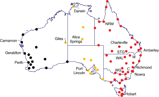
There were 72 sites ultimately selected for this study (Fig. 1), using data from 2012 to 2020. Sites were excluded if they had insufficiently complete data1 over the 2012–2020 period, had a probe type or significant site change during that period or had other known data quality issues during that time. The sites extend over most of Australia, although coverage is sparse in the north-west. The great majority (62) of these locations use Rosemount probes, with Temp Control probes in use at nine sites and Wika probes at one. The 2012 start date is chosen to maximise the number of available sites with no probe type changes during the analysis, as there were numerous probe type changes in 2010–2011.
Observing stations used in the study. Stations named in the text are labelled. C, Canberra; M, Moree; NRM, Normanton; STG, St George; WAL, Walgett; WG, Wagga Wagga. Colours indicate the time zone of the station: UTC + 8 (black), UTC + 9.5 (orange), UTC + 10 (red).
The N-min temperature variation is defined as the difference between the highest and the lowest temperatures observed during the N-minute window (for N > 1, this is defined as the highest (lowest) value of the N individual values for the highest (lowest) temperature within the minute). In all cases, standard time2 is used (not daylight saving time in those locations where it applies).
3.Results
3.1. Diurnal and seasonal patterns of short-period variations
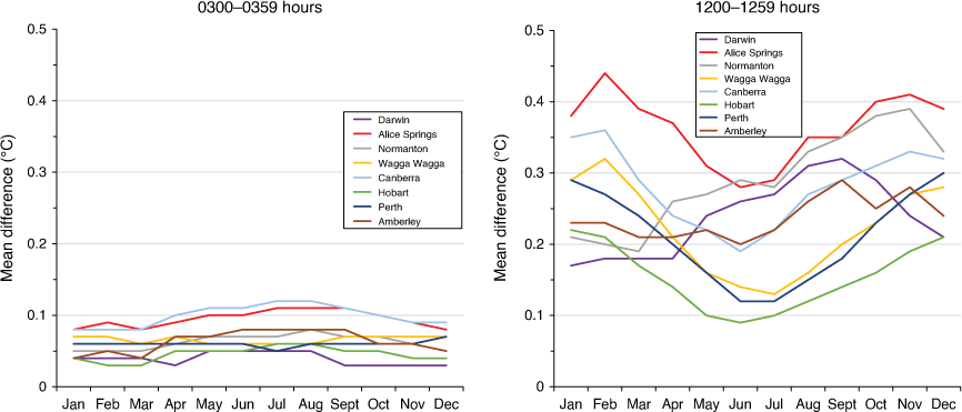
Mean 1-min temperature variations show a clear diurnal cycle (Fig. 2), rising from sunrise, peaking near noon local time before falling later in the day. Values during the night-time hours are relatively uniform at most locations. The diurnal cycle is generally weaker in winter, and becomes more irregular at those locations that have elevated variability during the night compared with other sites (section 3.2). Some such locations also show some evidence of a minimum in variability near sunset in winter before rising to a stable level for the rest of the night, most visible in Fig. 2 at Canberra in July.
Mean 1-min temperature variation by hour of the day for selected locations, for January (left) and July (right). In these graphs, 1 h incorporates data at times from the stated hour to 59 min past the hour (e.g. ‘9’ encompasses 0900–0959 hours inclusive).

Fig. 3 shows 1-min temperature variations by month for the periods 1200–1259 and 0300–0359 hours, representing the approximate maximum and minimum of the diurnal cycle respectively. The 1-min temperature variations at most locations during the day are highest in summer and lowest in winter. The major exceptions to this are in tropical locations with a strongly defined summer rainy season. At these locations, the highest values typically occur prior to the onset of the core of the wet season, towards the end of the calendar year, before decreasing during the peak of the wet season. At night, there is a weak seasonal cycle in most locations, with a tendency towards a slight winter maximum.
3.2. Spatial patterns of short-period variations
Fig. 4 shows mean 1-min temperature variations for January and July, for the time periods 0300–0359 and 1200–1259 hours, taken as representative of overnight and peak daytime conditions respectively.
Mean 1-min temperature variation at each location for 0300–0359 hours (left) and 1200–1259 hours (right), in January (top) and July (bottom).
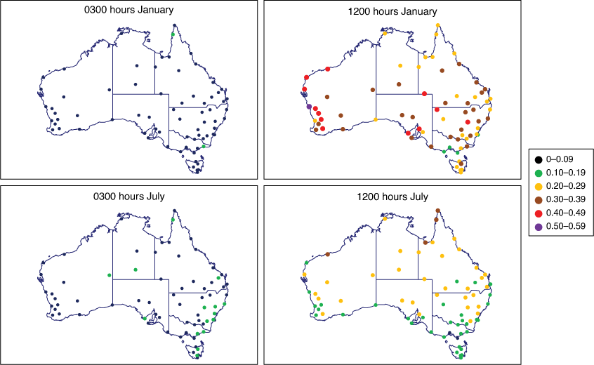
During daytime in January, the highest values are typically recorded in arid and semi-arid climates3 in the subtropics, extending to the west coast, with numerous locations having mean January values at 1200–1259 hours in the 0.4–0.5°C range. Similar values also occur at a few coastal locations that have large land-sea temperature contrasts and are susceptible to sudden-onset seabreezes, such as Carnarvon, Geraldton and Port Lincoln, although there are many other coastal locations that do not show this behaviour. Values are lower (typically 0.2–0.3°C) in the northern tropics, which are well into their wet season by January. The lowest January values, ~0.2°C, mostly occur in southern Victoria and Tasmania.
In July, the pattern is broadly latitudinal, with the highest daytime values in northern Australia that are in the middle of their dry season. Most locations north of 20°S have mean July values at 1200–1259 hours between 0.25 and 0.35°C, whereas most sites south of 30°S are below 0.2°C. As in summer, the lowest values are in southern Victoria and Tasmania, with a number of sites near or below 0.1°C.
At night, values are relatively geographically uniform, with mean 1-min variations between 0.05 and 0.10°C at most locations in both January and July. There are, however, a small number of sites, predominantly but not wholly in the inland southeast, which show elevated 1-min variations at night (mostly in the 0.10–0.15°C range) in winter. To the extent that a generalisation is possible, most of these sites are in valley locations susceptible to cold-air drainage, which can lead to rapid temperature fluctuations at night if cold surface layers are mixed by winds, or reform after winds drop out – leading to rapid warming and cooling respectively. However, not all such ‘frost hollow’ sites have abnormally high 1-min variations at night. A few sites with elevated overnight 1-min variations are also located near the base of slopes (e.g. Port Lincoln, Richmond, NSW, and Nowra) and may experience katabatic flows.
In general, the 10 sites that have Temp Control or Wika probes show results broadly consistent with other sites in their region, indicating that large systematic differences between the three probe types are unlikely.
3.3. Potential influence of antecedent land surface conditions
In general, mean 1-min temperature variations at most sites show relatively little interannual variability, with very few instances of mean annual daytime values in any individual year deviating by more than 0.05°C from the 2012–2020 mean at that location.
There is some evidence of 1-min temperature variability being suppressed during and after abnormally wet periods. There are insufficient data to assess this systematically, due to the short period of record (2012–2020), while controlling for cloud amount is also difficult because of inconsistent total cloud amount data from the mid-2010s onwards as the Bureau observation network was progressively automated.
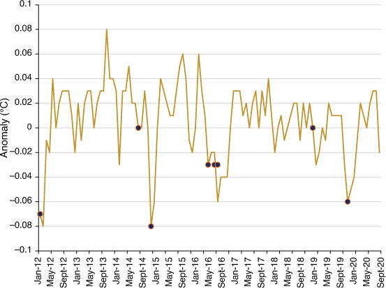
One case study considered was the region of southern inland Queensland and northern inland New South Wales. This region experienced drought for much of the period from autumn 2012 to the end of 2019, interrupted by an abnormally wet period from June to September 2016 (Bureau of Meteorology 2016). Conditions were also abnormally wet at the start of 2012 and in the first quarter of 2020.
Two sites were considered in this region: Charleville (Queensland) and Walgett (New South Wales). (Two other sites, St George and Moree, were excluded because of possible confounding effects from extensive irrigated agriculture in relatively close proximity.) Monthly anomalies of daytime 1-min temperature variations at Charleville are shown in Fig. 5, with months in which more than double the monthly mean rainfall occurred identified. The 1-min temperature variations show mean monthly anomalies in such months, on average, of −0.04°C, but the mean anomaly in the month immediately following the very wet month is also −0.04°C. At Walgett, the mean monthly anomaly values are −0.07 and −0.06°C respectively. Of particular note is that following the very wet period from June to September 2016 (when rainfall over the region was approximately three times normal and at or near record levels), 1-min temperature variability was suppressed at both locations until the end of 2016, even though rainfall was near or below normal from October onwards. These lagged effects suggest a possible role for the land surface in modifying short-period temperature variability, through changes in soil moisture, vegetation response to the rainfall, or both, although the limited sample makes it difficult to draw firm conclusions.
3.4. Estimating maximum and minimum temperatures from fixed-time observations
Knowledge of the characteristic range of variation of temperatures within a short time window also allows estimation of likely minimum and maximum temperatures from fixed-time observations if they are sufficiently closely spaced (e.g. hourly). Two potential applications of this information are to estimate daily maximum and minimum temperatures if only fixed-time observations are available, and to assess the likelihood that the day’s maximum and minimum temperature has been missed during an outage.
For each hour from 0000 to 2300 hours, the difference between the temperature at that time, and the highest and lowest reached in the N minutes after that time (where N = 5, 10, 15, … 60), was calculated. This allows a frequency distribution of the differences to be calculated as a function of the hour, the calendar month and the length of the period considered. Although all hours were considered, results are presented for 0500 and 1500 hours, corresponding to typical times of occurrence for minimum and maximum temperature respectively. The 50th percentile of the differences is most useful for determining the most likely value of the maximum and minimum between fixed-time observations, whereas the 5th and 95th percentiles are useful for defining a range that the maximum and minimum temperature is unlikely to have gone outside.
Fig. 6 shows the 50th and 5th/95th percentiles of the differences for selected stations as a function of the length of time considered. The increase in the difference with increased time interval is only gradual for the extreme percentiles beyond the first 5 min, particularly for maximum temperature, where it is relatively common for the 95th percentile difference to have already exceeded half its 60-min values by the first 5 min.
Difference between the temperature at a fixed time and the highest and lowest in the following N minutes at selected sites: (dotted lines) 50th percentile of the difference; (solid lines) 5th percentile (for 0500 or lowest) and 95th percentile (for 1500 or highest). Differences between the temperature at 0500 hours and the lowest in the following N minutes are shown as negative values.
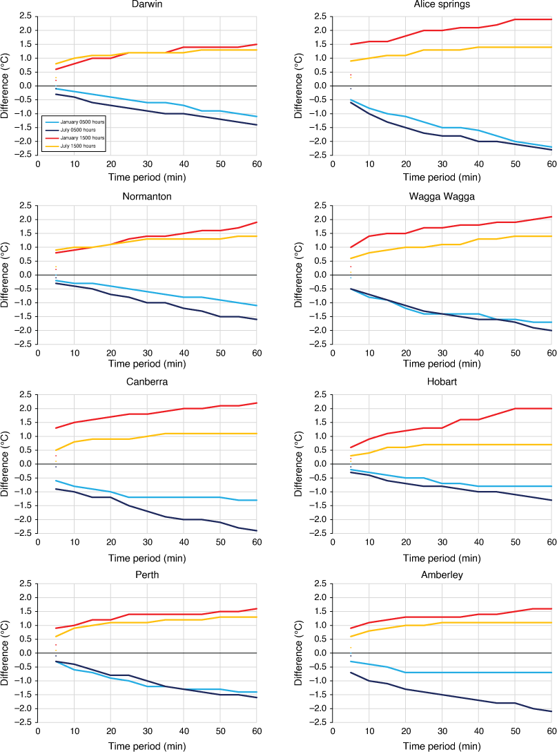
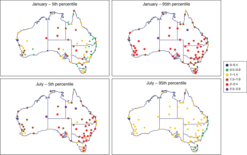
At most locations, the 95th percentile of the difference between the highest temperature reached in the 60 min after 1500 hours and the temperature at 1500 hours is between 1.5 and 2.5°C in January, and between 1.0 and 1.5°C in July (Fig. 7). This implies that if there is a break in observations that lasts less than 60 min, and the temperature at the start and end of the outage is more than 2.5°C (January) or 1.5°C (July) lower than the highest reached on the day outside the outage period, it is unlikely that the day’s maximum temperature was missed during the outage. Lower thresholds can be drawn for shorter periods, although even for a gap as short as 5 min, the 95th percentile of the difference can be more than 1°C. Similarly, for minimum temperature, the 5th percentile of the difference between the lowest temperature reached in the 60 min after 0500 hours and the temperature at 0500 hours is between 1.0 and 1.5°C at most locations in January, and 1.5 and 2.0°C in July. Those sites that show elevated 1-min temperature variability on winter nights (section 3.2) for local geographic reasons also tend to show larger differences between minimum temperature and fixed-hour observations, with a value as high as 2.9°C at Giles in July. This also extends to some of those low-lying sites that did not show elevated 1-min variability (for example, 2.2°C in July at Rutherglen, where the mean 1-min variation at 0300 hours is only 0.07°C).
Differences for January (top) and July (bottom) between the temperature at a fixed hour and the highest and lowest temperature observed in the next 60 min: (left) 5th percentile, 0500 hours and lowest in the period 0500–0600 hours and (right) 95th percentile, 1500 and highest in the period 1500–1600 hours.
For the 50th percentile (not shown), the equivalent differences for 1500 hours are in the order of 1.0°C for most sites in January, falling to ~0.5°C at some sites on the eastern and southern coasts, whereas in July they range from ~0.2°C in southern Australia to ~0.7°C in the north. For 0500 hours, typical values are 0.2–0.4°C in January and 0.3–0.6°C in July. Both winter minima and summer maxima show weaker geographic patterns for this indicator than they do for 5th and 95th percentiles or mean 1-min variations.
4.Applications in data quality control
A common test used in the quality control of climate data (e.g. World Meteorological Organization 2010, 2018) is a test for rapid changes where an observation is compared with the immediately preceding and following observations, and flagged if it shows an excessively large difference with those observations. A necessary part of implementing such a test is to set an appropriate threshold that detects the largest possible number of genuine errors while minimising the number of false positives. The results presented here can potentially be used in setting such thresholds.
At most locations, the proportion of minutes in which the temperature varies by more than 0.5°C is between 2 and 5%, with the highest values ~8%. The proportion in which variation of more than 1°C is observed is below 0.2% (which equates to 2.88 observations per day on average) at most locations, although this rises to 0.4–0.6% at a few locations in central and western Australia.
These results imply that, if 1-min data are being used for ‘spike’ tests, a threshold lower than 1°C is likely to result in a substantial number of false positives. As temperatures on these timescales are generally more variable during the day and during summer, it may be appropriate to have different thresholds for this test for high extremes to those used for low extremes.
Some more extreme cases exist, especially in arid climates. One notable example occurred on 13 November 2014 at Alice Springs, when the temperature reached 44.9°C (a November record for the site). In the minute when the maximum was observed, at 1616 hours, there was a 4.9°C difference between the highest and lowest temperature, and no temperature above 42°C was observed in the 5 min preceding and following. A difference of greater than 4°C between the highest and lowest temperature of the minute also occurred at 1603 and 1606 hours. (There was a rapid increase in wind speed at both 1603 and 1616 hours compared with the preceding minute, suggesting local turbulence.) A liquid-in-glass thermometer in the same screen as the probe recorded a daily maximum of 44.6°C, and one in a second screen nearby registered 44.5°C, indicating that the 44.9°C maximum from the automated probe, and hence the very large within-minute fluctuation, is probably valid. This illustrates that on rare occasions, very rapid temperature fluctuations can legitimately occur, and automatically rejecting them without further scrutiny may lead to the loss of genuine extremes.
5.Concluding remarks
This paper presents a climatology of temperature variations at Australian stations with sub-hourly resolution. Temperature changes within periods as short as 1 min can be quite substantial, with changes over that time greater than 0.5°C occurring in more than 2% of minutes at most stations. The largest variations generally occur in summer (or, in the tropics, towards the end of the dry season) and in the middle of the day, and are generally larger in arid climates than in moister ones. This may indicate a role for turbulence in the boundary layer as a driver for temperature variability on short timescales but further work would be necessary to assess such a proposition more rigorously. The 1-min temperature variations at night are generally much smaller than those during the day, particularly in summer, but in winter, overnight temperatures can vary on hourly timescales to a similar extent to summer daytime temperatures, particularly at sites susceptible to katabatic winds or cold air drainage.
Instruments that have a different response time to those used in this study will sample short-period variations differently. This has the potential to create biases in maximum and minimum temperature should instruments be used that have substantially different characteristics to those currently used in the Australian automated observing network, although the magnitude of such biases is reduced by virtue of the 1-min temperature variability around the normal time of maximum temperature (c. 1500 hours at most sites) being somewhat lower than its midday peak. An assessment (Trewin et al. 2020) found no significant impacts from such effects in the Australian maximum and minimum temperature record.
The results provide a basis for objective data quality control tests. Very large temperature changes can occasionally occur over periods as short as 1 min, and it is hence inevitable that quality control tests for rapid changes, unless they use thresholds so high as to detect only the largest errors, will have some level of false positives, especially in arid climates. Although data volumes for 1-min data are such that only fully or almost fully automated quality control is likely to be feasible, this illustrates the utility of some level of manual augmentation of automated quality control systems for key elements, particularly in assessments of extreme events.
Data availability
Data used in this study can be obtained on request from the Bureau of Meteorology (http://www.bom.gov.au/climate/data-services/).
Conflicts of interest
The author is an editor for the Journal of Southern Hemisphere Earth Systems Science but did not at any stage have editor-level access to this manuscript while in peer review, as is the standard practice when handling manuscripts submitted by an editor to this journal. JSHESS encourages its editors to publish in the journal and they are kept totally separate from the decision-making processes for their manuscripts. The author has no further conflicts of interest to declare.
Acknowledgements
Comments from Mitchell Black, Katie Rosemond, Avijeet Ramchurn and William Wang on earlier versions from this manuscript are gratefully acknowledged.
References
Ayers GP (2019) A comment on temperature measurement at automatic weather stations in Australia. Journal of Southern Hemisphere Earth Systems Science 69, 172-182.
| Crossref | Google Scholar |
Ayers GP, Warne JO (2020) Response time of temperature measurements at automatic weather stations in Australia. Journal of Southern Hemisphere Earth Systems Science 70, 160-165.
| Crossref | Google Scholar |
Bureau of Meteorology (2016) Record September rains continue wet period in much of Australia. Special Climate Statement 58. Available at http://www.bom.gov.au/climate/current/statements/scs58.pdf [Verified 12 November 2021]
Burt S, de Podesta M (2020) Response times of meteorological air temperature sensors. Quarterly Journal of the Royal Meteorological Society 146, 2789-2800.
| Crossref | Google Scholar |
Hamann RR (1943) The remarkable temperature fluctuations in the Black Hills region, January 1943. Monthly Weather Review 71, 29-32.
| Crossref | Google Scholar |
McPherson RA, Lane JD, Crawford KC, McPherson WG, Jr (2011) A climatological analysis of heat bursts in Oklahoma (1994–2009). International Journal of Climatology 31, 531-544.
| Crossref | Google Scholar |
Trewin BC (2018) The Australian Climate Observations Reference Network – Surface Air Temperature (ACORN-SAT) version 2. Bureau Research Report 32. (Bureau of Meteorology) Available at http://www.bom.gov.au/research/publications/researchreports/BRR-032.pdf [Verified 12 November 2021]
Trewin B, Braganza K, Fawcett R, Grainger S, Jovanovic B, Jones D, Martin D, Smalley R, Webb V (2020) An updated long-term homogenized daily temperature data set for Australia. Geoscience Data Journal 7, 149-169.
| Crossref | Google Scholar |
World Meteorological Organization (2010) Guide to the global observing system. WMO-No. 488. (WMO: Geneva, Switzerland) Available at https://library.wmo.int/doc_num.php?explnum_id=4236 [Verified 12 November 2021]
World Meteorological Organization (2018) Guide to instruments and methods of observation. Volume III: observing systems. WMO-No. 8. (WMO: Geneva, Switzerland) Available at https://library.wmo.int/doc_num.php?explnum_id=9872 [Verified 12 November 2021]
Footnotes
1 Sites were required to have at least 15 days of data at 1-min resolution in each month from January 2012 to December 2020.
2 This is UTC + 8 h for all sites in Western Australia (except Giles), UTC + 9.5 h for Giles and all sites in South Australia and the Northern Territory and UTC + 10 h for all other sites.
3 Maps of Australian climate zones are available at http://www.bom.gov.au/jsp/ncc/climate_averages/climate-classifications/index.jsp.