
Atmospheric rivers in the Australia-Asian region: a BoM–CMA collaborative study
Chengzhi Ye A , Huqiang Zhang B E , Aurel Moise B C and Ruping Mo DA Hunan Meteorological Service, Changsha, China.
B Bureau of Meteorology, Melbourne, Vic., Australia.
C Centre for Climate Research Singapore, Meteorological Service Singapore, Singapore.
D Environment and Climate Change Canada, Vancouver, Canada.
E Corresponding author. Email: Huqiang.Zhang@bom.gov.au
Journal of Southern Hemisphere Earth Systems Science 70(1) 3-16 https://doi.org/10.1071/ES19025
Submitted: 29 March 2019 Accepted: 28 August 2019 Published: 28 August 2020
Journal Compilation © BoM 2020 Open Access CC BY-NC-ND
Abstract
The name ‘atmospheric river’ (AR) could easily be misinterpreted to mean rivers flowing in the sky. But, ARs actually refer to narrow bands of strong horizontal water vapour transport that are concentrated in the lower troposphere. These bands are called ‘atmospheric rivers’ because the water vapour flux they carry is close to the volume of water carried by big river systems on the ground. ARs can cause heavy rainfall events if some physical mechanisms, such as orographic enhancement, exist to set up the moisture convergence and vertical motions necessary to produce condensation. In recent decades, these significant moisture plumes have attracted increasing attention from scientific communities, especially in North America and western Europe, to further understand the connections between ARs and extreme precipitation events which can trigger severe natural disasters such as floods, mudslides and avalanches. Yet very limited research has been conducted in the Australia-Asian (A-A) region, where the important role of atmospheric moisture transport has long been recognised for its rainfall generation and variations. In this paper, we introduce a collaborative project between the Australian Bureau of Meteorology and China Meteorological Administration, which was set up to explore the detailed AR characteristics of atmospheric moisture transport embedded in the A-A monsoon system. The project in China focused on using AR analysis to explore connections between moisture transport and extreme rainfall mainly during the boreal summer monsoon season. In Australia, AR analysis was used to understand the connections between the river-like Northwest Cloud Band and rainfall in the region. Results from this project demonstrate the potential benefits of applying AR analysis to better understand the role of tropical moisture transport in rainfall generation in the extratropics, thus achieve better rainfall forecast skills at NWP (Numerical Weather Prediction), sub-seasonal and seasonal time scales. We also discuss future directions of this collaborative research, including further assessing potential changes in ARs under global warming.
Keywords: atmospheric river, extreme rainfall, monsoon, narrow band of strong moisture transport, Northwest Cloud Band, weather and seasonal forecasts.
1 Introduction
Atmospheric rivers (ARs) have received increasing attention from meteorological and hydrological communities in recent decades due to the close association of ARs with extreme rainfall events, mainly occurring on the western coasts of North America (Zhu and Newell 1994; Ralph et al. 2004, 2006; Neiman et al. 2008a, 2008b; Smith et al. 2010; Dettinger et al. 2011; Warner et al. 2012, 2015; Gershunov et al. 2017, 2019; Mo et al. 2019), South America (Garreaud 2013; Viale et al. 2018) and Europe (Lavers et al. 2011, 2012; Lavers and Vilarini 2013, 2015). As Ralph et al. (2017) pointed out, there has been a rapid increase in scientific publications on ARs, from a few in the 1990s to over 200 per year in recent years. The analogy to ‘river’ could be misleading, because it can be misinterpreted as suggesting there are rivers in the sky operating like these on the ground, with fixed channels and tributaries. Instead, the term refers to narrow bands of strong horizontal water vapour transport concentrated in the lower troposphere, which can cause extreme rainfall when these moisture belts meet with some dynamical lifting mechanisms, such as orographic uplift. Nevertheless, the terminology of AR, which was coined by Zhu and Newell (1994, 1998), has now been widely accepted in the scientific literature (Gimeno et al. 2014; Ralph et al. 2017). These bands are called ‘atmospheric rivers’ because if the water vapour flux carried within them were to precipitate out, the volume of water would be equivalent to that transported by big river systems on the ground (Zhu and Newell 1994).
Fig. 1 shows the characteristics of a typical AR making landfall in western Canada at 0000 UTC 29 January 2018. It fits well with the conceptual model for the ARs over the Northeast Pacific shown in Gimeno et al. (2014) based on an observational campaign over the west coast of North America (Ralph et al. 2004). This AR, bounded by the 20-mm contour of vertically integrated water vapour (IWV), was a long (expanding well beyond 2000 km in length), narrow (on average with ~500–800 km width) and shallow (1–2.5 km in depth) band of strong horizontal water vapour transport in the lower troposphere. It was associated with a strong pre-cold frontal low-level jet (LLJ) as documented by many other studies (Ralph et al. 2004, 2005; Neiman et al. 2008a, 2008b; Gimeno et al. 2014). Another important feature in Fig. 1 is that, at the AR head (shown at Port Hardy, BC, Canada), the sounding profiles of temperature and dewpoint temperature suggest that its vertical distribution followed closely to a near moist-neutral stratification. On the west coast of North America, AR centres are usually located at a level lower than the coastal mountains. Therefore, when they make landfall on the coast, the orographic enhancement of rainfall can lead to extreme precipitation events (Ralph et al. 2004, 2006; Neiman et al. 2008a, 2008b).

|
Nevertheless, when the AR concept was first introduced in the 1990s, there were debates on the differences between ARs and other concepts already used for describing moisture sources and transport in extratropical rainfall generation, such as the warm conveyor belts (WCBs) and tropical moisture exports (TMEs). The distinct and complementary concepts used in exploring atmospheric moisture transport outside the tropics were not properly defined until an international AR workshop in 2015 (Dettinger et al. 2015), where consensus was reached. As shown in Fig. 2 which follows another conceptual diagram in Dettinger et al. (2015), it is now generally agreed that a WCB refers to a zone of dynamically uplifted heat and moisture transport close to a midlatitude cyclone. The atmospheric moisture is often transported into the WCB by an AR. TMEs are zones of intense atmospheric moisture transport out of the tropics, and that tropical originated water vapour is frequently conducted by ARs toward cyclones and WCBs. Note that TMEs provide important vapour sources for ARs, but most ARs also incorporate midlatitude sources and convergences of vapour along their paths (Sodemann and Stohl 2013; Dettinger et al. 2015).
|
Numerous studies in the last decades have documented the AR contribution to large-scale water vapour transport and extreme precipitation events in orographically favoured locations around the world (Smirnov and Moore 1999; Gyakum 2000; Ralph et al. 2004, 2005, 2006; Neiman et al. 2008a, 2008b; Roberge et al. 2009; Lavers et al. 2011, 2012; Newman et al. 2012; Lavers and Villarini 2013; Guan and Waliser 2015; Mahoney et al. 2016; Ralph et al. 2017; Browning 2018; Zhang et al. 2019). However, this relatively new meteorological terminology has not been generally adopted in the Australia-Asian (A-A) region, except for a few recent studies (Hirota et al. 2016; Paltan et al. 2017; Yang et al. 2018). It is well known that weather and climate in the Asian region are dominated by monsoonal flows that bring warm and moist air from the tropics into the subtropical and extratropical areas (Ding 2004; Zhang 2010) through several channels (Chen et al. 1991; Chang et al. 2004; Ding 2004; Wang 2006), but it is unclear to what extent such transport is realised as ARs and/or other mechanisms. We note that several recent studies started to analyse ARs in the Asian monsoon region (Hirota et al. 2016; Yang et al. 2018), but it is unclear whether the established AR conceptual model can be directly applied in the A-A monsoon system and to what extent the monsoon rainfall intraseasonal variations are associated with its AR activities.
Another attraction of conducting AR analysis in the Australian region is a significant weather phenomenon known as the Northwest Cloud Band (NWCB). As described by Tapp and Barrell (1984), in satellite weather images the NWCB is a river-like, long and narrow band (typically extending over 2500 km and existing for two to four days) that often originates in the warm and moist Indian Ocean, south and west of Indonesia. It thus bears a strong similarity to the AR phenomenon. Wright (1997) showed the NWCB as one of the synoptic patterns that results from tropical–extratropical interactions. Studies from Frederiksen and Balgovind (1994) and Frederiksen and Frederiksen (1996) further linked the formation of NWCB with sea surface temperature (SST) gradients in the Indian Ocean. Using a general circulation model, Frederiksen and Balgovind (1994) simulated an increased frequency of NWCB with enhanced SST gradients between the Indonesian Archipelago and the central Indian Ocean and with enhanced influx of warm tropical air from northwest Australia. In a follow-up study, Frederiksen and Frederiksen (1996) used a two-level primitive-equation model to demonstrate that an enhanced SST gradient can produce instability modes resembling circulation changes surrounding the onset of NWCB.
Although NWCBs are likely to produce extensive rainfall over Australia, their effectiveness in generating heavy precipitation is still under debate (Ummenhofer et al. 2011). The complex relationship between NWCB and rainfall could partly be attributed to the different atmospheric moisture sources that support the formation of the cloud band. Early studies, such as Hill (1977), stressed the importance of tropical thunderstorm activity in injecting tropical warm and moist air into the midtroposphere, which is then advected south-eastwardly along the band. However, Tapp and Barrell (1984) showed that tropical convection is not always evident near the origin of NWCB. Early studies of Hill (1964, 1969, 1977) also showed the importance of a second NWCB-supporting moisture source off eastern Australia. Therefore, AR analysis has the potential to offer some insight into the formation of NWCB, its moisture source and transport, and how these processes affect its rainfall effectiveness.
Given the lack of assessment of ARs and the importance of their moisture transport in affecting the weather and climate in the A-A region, a bilateral project on AR research was conducted over 2017–2019 under a cooperation agreement between the China Meteorological Administration (CMA) and the Australian Bureau of Meteorology (BoM). This collaborative project was designed to fill the gap in AR research and apply this diagnosis for supporting weather and climate services in the region. Some preliminary results were presented at the 2018 Australian Meteorological and Oceanographic Society-International Conference on Southern Hemisphere Meteorology and Oceanography (5–9 February, Sydney, Australia), and a special issue of the Journal of Southern Hemisphere Earth Systems Science has been arranged to publish these results to promote AR studies in the region. The main purpose of this paper is to provide a scientific background on AR research, list key scientific questions addressed by this project, report on the project’s progress and discuss future directions.
The remainder of this paper is organised as follows. Section 2 gives a brief overview of ARs, their detections and current applications in regions outside the A-A region. Section 3 reviews key scientific questions addressed by our BoM-CMA collaborative project and highlights some important results from the project. In Section 4, the limits from current studies and future directions of this collaborative project are discussed.
2 Atmospheric rivers: an overview
2.1 A brief historical perspective
As shown in Fig. 1, an AR can be generally defined as a long, narrow and transient corridor of strong horizontal water vapour transport (American Meteorological Society 2019). The concept of a ‘river’ in the sky was introduced in the early 1990s to describe some filamentary structures of atmospheric water vapour transport. In a pilot study, Newell et al. (1992) showed the presence of these moisture filaments, which have lengths many times their widths and persist for many days while being transported through the lower atmosphere. They termed these features ‘tropospheric rivers’, given that some of them may carry as much water as the Amazon River. The name ‘atmospheric river’ was used in a later article by Zhu and Newell (1994) (also see Newell and Zhu 1994). The great importance of ARs in large-scale water vapour transport was further recognised by Zhu and Newell (1998), who showed that ARs may carry essentially the total meridional moisture transport observed in the extratropical atmosphere, despite occupying only about 10% of the total longitudinal length at a given latitude.
Before the AR concept was widely known and accepted, some studies used the term ‘Pineapple Express’ to describe the strong LLJs blowing from the Hawaiian area (where pineapples are grown) towards the west coast of North America (e.g. Lackmann and Gyakum 1999; Mo et al. 2009). Other names used for describing the strong water vapour transport in the atmosphere include ‘moisture conveyor belt’ (Bao et al. 2006), ‘Maya Express’ (Dirmeyer and Kinter III 2009) and ‘tropical moisture export’ (Knippertz and Wernli 2010). Nevertheless, since the influential paper by Ralph et al. (2004), the term ‘atmospheric river’ has been adapted and received great publicity in the meteorological and hydrological communities. Numerous recent studies have demonstrated that ARs play a crucial role in determining the occurrence of floods, breaking of droughts and managing water resources in many parts of the world (Gimeno et al. 2014; Ralph et al. 2017 and references therein). As illustrated in Fig. 2, the general view now is that ARs provide the link between moisture sources in the tropics (TMEs) and the moisture embedded within the middle-latitude WCBs, and ARs are directly responsible for some heavy precipitation events (Sodemann and Stohl 2013; Dettinger et al. 2015).
In the A-A monsoon region, Zhu and Newell (1998) found that persistent monsoon circulations are supported by transient filamentary water vapour fluxes. These features may be considered as semipermanent ARs. Joseph and Moustaoui (2000) used a simple, dynamically consistent model to demonstrate the development of filamentary moisture transport in a monsoon-like flow. He et al. (2007) described some patterns of strong large-scale moisture transport in the A-A monsoon region as ‘great moisture rivers’. They found that the precursory signals in the seasonal transition from the winter to summer pattern could be revealed by the establishment of a strong southerly total moisture transport value exceeding 100 kg m−1s−1. The terminology of AR has been adopted in some recent studies in the A-A monsoon region (e.g. Hirota et al. 2016; Paltan et al. 2017; Yang et al. 2018). However, there is still a lack of understanding about whether ARs embedded in the large-scale monsoonal flow are an important mechanism for moisture transport in the monsoon system and to what extent AR activities have contributed to monsoon intraseasonal rainfall variations.
2.2 Methods for atmospheric river detection
The two most frequently used approaches to detect and define ARs are integrated water vapour (IWV) and integrated vapour transport (IVT), which can be defined as:

where g is the acceleration of gravity, q is the specific humidity, Vh is the horizontal wind vector, Q is a two-dimensional IVT vector, p is the pressure taken as the vertical coordinate, and ps is the surface pressure. The vertical integrations in Eqn 1 are carried out from the Earth’s surface to the top of the atmosphere. Therefore, the IWV represents the total mass of water vapour per unit area above the Earth’s surface. It is also called the ‘precipitable water’. The IVT is the magnitude of Q, representing the total horizontal transport of water vapour per unit area above the Earth’s surface. Note that both IWV and IVT are dominated by conditions in the lower troposphere because of the rapid decrease of specific humidity with altitude. In practice, it suffices to carry the vertical integration up to the 300 hPa level in the upper troposphere, but for the convenience of operational application implementation, one can choose to simply take the IWV value integrated from the surface to the top of the atmosphere, as this variable is often saved in numerical model outputs.
Ralph et al. (2004) showed that the IWV derived from meteorological satellite observations can be used as a proxy for detecting the presence of ARs: an AR is defined as an elongated area with a minimum IWV threshold of 20 mm, a minimum length of 2000 km and a maximum width of 1000 km. Their analysis found a close correlation between IWV and IVT in the midlatitudes, and the identified ARs were typically associated with the pre-cold-frontal LLJs within oceanic extratropical cyclones (Ralph et al. 2005). This IWV-based AR definition has been successfully applied in many subsequent studies (Ralph et al. 2006; Neiman et al. 2008a, 2008b; Guan et al. 2010; Dettinger et al. 2011; Ralph et al. 2011; Ralph and Dettinger 2012). An automated objective algorithm for the AR identification based on IWV has also been developed by Wick et al. (2013).
Because the IWV-based AR definition does not include wind information, it does not address the fundamental processes for water vapour transport. When both wind and moisture data are available, IVT is a more appropriate variable for the AR definition (Zhu and Newell 1998; Lavers et al. 2012; Lavers and Villarini 2013; Wick 2014; Guan and Waliser 2015; Mahoney et al. 2016; Mo and Lin 2019). A range of definitions and thresholds are used in various studies, and currently there is an intercomparison project to compare results from these studies (Shields et al. 2018). Rather than using a fixed threshold, Guan and Waliser (2015) developed a technique for objective AR detection using varying thresholds based on the IVT distributions calculated from reanalysis data covering a long period (normally over 30 years). They used the 85th percentile of IVTs with geometry requirements of >2000 km length and a length/width ratio >2 as the AR-defining threshold. There is merit in such a definition, as the magnitude of atmospheric moisture transport and its impacts on rainfall may vary with different climate backgrounds. For operational applications, a simpler definition can also be given as an elongated area with a minimum IVT threshold of 250 kg m−1 s−1, a minimum length of 2000 km and a length/width ratio >2 (e.g. Wick 2014; Mo and Lin 2019).
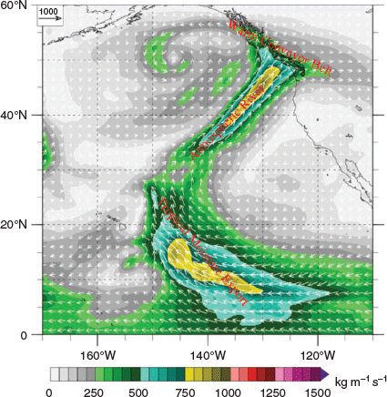
Mahoney et al. (2016) pointed out that the IVT-based AR definition is particularly useful for distinguishing the strong moisture transport corridor where the climate background is moist, such as in southeast USA. This is likely also true in the A-A monsoon region. As an example, Fig. 3 shows the IWV and IVT distributions at 1800 UTC January 2017, derived from the Japanese 55-year Reanalysis (JRA-55) (Kobayashi et al. 2015; Harada et al. 2016). Based on the IWV-based definition, we can readily identify a strong AR from the tropical western Pacific towards the west coast of North America in Fig. 3a (Mo et al. 2019). In addition, several ARs can also be identified in the extratropical areas of the South Indian Ocean, the South Pacific Ocean and the Atlantic Ocean. There is an indication of a weak AR along the south coast in Australia. On the other hand, the AR signal over the southeast USA is poorly defined. By comparison, as corridors of strong water vapour transport, the ARs are better distinguished by the IVT-based definition in Fig. 3b. In particular, the ARs across the southeast USA and Australia can be readily recognised in Fig. 3b.

|
As pointed out by Shields et al. (2018), different methods used to detect ARs on numerical model gridded datasets and/or reanalysis data can vary substantially in the derived AR characteristics (including frequency, duration and intensity) due to the different chosen methods. It is hard to choose one against another without a reference dataset to compare. Therefore, in the BoM-CMA project, we dedicated significant resources to conduct manual AR detections by combining IVT calculations from six-hourly JRA-55 data (https://jra.kishou.go.jp/JRA-55/index_en.html) with manually checked daily synoptic charts and satellite images. This effort was to make sure that the detected ARs not only satisfy certain thresholds often used in the automatic schemes but they also actually exist as recognisable weather patterns in an operational weather forecasting environment. Detailed description is provided by Wu et al. (2020) in this special issue. Our AR dataset covers the AR events in Australia and China domains for 1977–2016. This will serve as the reference dataset in our future selection of a suitable automatic detection algorithm that will allow us to implement the AR diagnosis in operational systems.
In general, the strength of precipitation is directly associated with the convergence of water vapour transport, rather than the strength of moisture transport (Benton and Estoque 1954; Mo and Lin 2019; Mo et al. 2019). Along the west coast of North America, when an AR approaches a mountain barrier, the deceleration of air motion can lead to strong moisture convergence on the windward side. This, together with the orographic uplift, can lead to heavy precipitation in the mountains and lowlands alike (Lackmann and Gyakum 1999; Mo et al. 2019). In addition, horizontal convergence and uplift may also be generated by other mechanisms, such as midlatitude frontal systems and blockings (e.g. Mo and Lin 2019). Different dynamical mechanisms for AR-induced heavy precipitation in the A-A region will be further explored in this BoM-CMA project through several case studies (Chen et al. 2020; Xu et al. 2020a).
3 Key scientific questions in this research
Although several studies have used global reanalysis datasets to document ARs in the global context (e.g. Guan and Waliser 2015; Gimeno et al. 2016; Waliser and Guan 2017), there is a lack of detailed analysis focusing on the ARs in the A-A region. In this section, we highlight some fundamental features of moisture transport in the monsoon region and discuss how AR diagnosis can be used to further improve our understanding of the monsoon system and the skills in forecasting monsoon rainfall at NWP, seasonal and climate time scales.
As pointed out in a review paper by Gimeno et al. (2016), there are two main moisture sources for precipitation, namely (i) continental evaporation/transpiration; and (ii) moisture transported from adjacent oceanic regions. Van der Ent et al. (2010) assessed the contribution of water recycling through land evapotranspiration to the generation of precipitation across the globe and estimated approximately 15–30% as the continental water recycling rate over the A-A summer monsoon region. Therefore, atmospheric moisture originating from tropical warm oceans plays a dominant role in supporting and sustaining rainfall over land.
Weather and climate in our region are dominated by the A-A monsoon, with a remarkable seasonal wind reversal. In the East Asian subtropical monsoon, the prevailing winds change from north-easterly in boreal winter into south-westerly (Chen et al. 1991; Ding 2004; Chang et al. 2004; Wang 2006; Zhang 2010). Associated with these monsoonal flows is a huge transport of warm and moist air out of the tropics, which produces heavy summer monsoon rainfall in the areas where strong moisture convergence occurs. The relationships of moisture transport (represented by IVT vector) with water vapour content in the atmosphere (represented by IVW) and rainfall over East Asia in the summer season can be seen in Fig. 4. The left panel shows the correlation vectors of monthly mean (June, July and August) IVT vectors with the area-averaged monthly mean IWV from the JRA-55 over three selected regions for the 30-year period of 1979–2018. The right panel shows the same correlation vectors, but with the area-averaged monthly precipitation from the Climate Prediction Center Global Unified Precipitation data (Chen et al. 2008; NOAA 2019). To highlight intraseasonal rainfall migration and the associated moisture transport in the course of the East Asian monsoon development, the three selected regions used in Fig. 4 are: (i) the southern domain (110oE–125oE, 20oN–30oN) in June when early monsoon rainfall is mainly located in southern China; (ii) the central-northern domain (110oE–125oE and 30oN–40oN) in July when heavy monsoon rainfall occurs in the Yangtze River and North China Plain area; and (iii) the far northeast domain (120oE–135oE and 35oN–45oN) in August when the monsoon rainfall advances further into northeast China, the Korean Peninsula and Japan. We see that the summer atmospheric water content and heavy rainfall in the East Asian region are driven by strong moisture transport from the tropics. There are clear correspondences to the well-known three preferred moisture channels for tropical moisture affecting the East Asian summer monsoon rainfall and its northward migration (Chen et al. 1991; Ding 1994, 2004; Chang et al. 2004): (i) the south-westerly flow from the Bay of Bengal; (ii) the southerly flow from the South China Sea region; and (iii) the anticyclonic south-easterly flow on the west flank of the Western Pacific Subtropical High (WPSH).

|
At the early stage of the East Asian summer monsoon, the large amount of IWV and high precipitation over South China (Fig. 4a and d) are supported mainly by the steady warm and moist south-westerly flow across the Bay of Bengal, Indochina Peninsula. At the same time, warm and moist airflow from South China Sea region provides another important moisture source. As the summer monsoon further develops and moves north-eastward in July and August, moisture carried by the anticyclonic flow of the WPSH becomes the dominant source for sustaining the heavy monsoon rainfall in subtropical and extratropical regions of East Asia.
The critical importance of the WPSH (its position, size and intensity) in influencing the summer rainfall in East Asia has been documented by many studies (e.g. Wang et al. 2013; Ying et al. 2017). To a large extent, it is the co-influence between the Tibetan Plateau and a semistationary WPSH that gives rise to the preferred moisture channels across East Asia during the boreal summer season. From the patterns displayed in Fig. 4, one can see some AR-like features, i.e. an elongated band of strong moisture transport. However, it is unclear if these bands reflect the collective effect of ARs occurring in the region for conveying moisture into the extratropics. It is also unclear whether there are different features between these East Asian ARs and the ones in North/South America. Consequently, the main tasks for this project in the East Asian region are defined around the following scientific questions:
What is the role of ARs in moisture transport in the Asian summer monsoon season, and are monsoon extreme rainfall events and their intraseasonal variations (active and break phases) associated with AR activities embedded within the large-scale monsoon flow?
What are the main characteristics of ARs embedded in the Asian monsoon system, which are mainly located inside continental East Asia, in contrast to the ones in North/South America? So far, most of the published AR studies have focused on moisture transport from the subtropics into the midlatitudes. In contrast, the AR studies in this project focus on detailed features of moisture transport embedded in the overall monsoon circulation, mainly in the subtropical area.
How skilful are current numerical weather prediction (NWP) models in forecasting ARs in the region, and can the AR forecast skill help us to indirectly extend our forecasts of extreme rainfalls during the Asian summer monsoon season?
What are the underlying drivers for the intraseasonal, seasonal and interannual variations of ARs in the A-A region, and what is the potential predictability of these ARs?
Although several studies, such as Waliser and Guan (2017) and DeFlorio et al. (2018), showed the AR occurrence in the Australian region, how it impacts on the regional weather and climate is far from clear. In contrast to the significant orographic blocking and the massive WPSH dominating the west Pacific which form the preferred channels for moisture transport into the East Asia, the topographic influence over the Australian continent is relatively weak. Therefore, ARs in Australia require stronger interactions between midlatitude cyclonic systems and subtropical systems to produce these long and narrow bands of moisture transport. Another key feature of our AR analysis in the Australian region is that we try to link moisture transport through ARs to some prominent synoptic patterns. As discussed in the Introduction, the river-like NWCB is an important weather phenomenon affecting large-scale rainfall in the continent. As an example, Fig. 5 shows a classic NWCB occurrence during 28–30 August 2016. Associated with this NWCB was a band of northwest–southeast rainfall across the continent. In this special issue, Chen et al. (2020) will provide a detailed analysis of the AR and NWCB features during this event.

|
In recent years, several studies identified the linkage between NWCB and SST conditions in the tropical Indian Ocean. Modelling and theoretical work from Frederiksen and Balgovind (1994) and Frederiksen and Frederiksen (1996) demonstrated that the SST gradients in the tropical Indian Ocean favoured the development of NWCB with an influx of tropical warm and moist air into northwest Australia. Further studies (e.g. Risbey et al. 2009a, 2009b; Ummenhofer et al. 2011; Frederiksen et al. 2014) showed that during the negative phase of the Indian Ocean Dipole (IOD) (warm over the eastern part of the tropical Indian Ocean and cooler over its western part), a region of above average rainfall tends to occur on the Australian continent from the northwest to the southeast, which is supported by enhanced moisture transport from the warm Indian Ocean into the Australian continent. All these suggest a potential role of ARs in the formation of NWCB.
To illustrate the linkage between moisture transport and rainfall variations in Australia, Fig. 6 shows correlation vectors of the monthly mean IVT with the area-averaged monthly rainfall in north-western and south-eastern parts of the region for June, July and August. For the north-western part, one can clearly see that rainfall variation is significantly linked to the enhanced moisture transport from the eastern part of the tropical Indian Ocean and nearby warm waters close to Indonesia. The elongated IVT patterns are of high similarity to moisture transport associated with NWCB.

|
Another feature in Fig. 6a–c is that the northwest–southeast extension of enhanced moisture transport becomes more evident in the late austral winter month (August) when midlatitude cyclonic systems penetrate more equatorward and their interactions with the subtropical anticyclonic system over the north-eastern part of the continent become much stronger. This is similar to the synoptic patterns associated with NWCB as discussed in Wright (1997). For the rainfall in the southeast, patterns in Fig. 6d–f tend to suggest that there is limited moisture transport directly from the northwest but the contribution of tropical moisture from the northeast increases. Indeed, instead of using moisture transport, Cai et al. (2011) used a wave propagation pathway to link the influence of IOD warming phases to the rainfall variations in southeast Australia. Therefore, the pathway of tropical-originated moisture affecting Australian rainfall is more variable compared to its East Asian counterpart. With these considerations in mind, in the Australian region, our project focused on:
Exploring the connections between ARs and NWCB. It is unclear if the long and narrow river-like NWCB is associated with an AR or the cloud band merely reflects the effect of midlatitude cyclonic dynamics, when such a system passes by. In this project, Chen et al. (2020) and Wu et al. (2020) have used backward trajectory analysis to explore the moisture source of ARs and found the moisture originating from the tropical Indian Ocean is indeed very important for NWCB rainfall generation in the interior of Australia. For rainfall in southeast Australia, the moisture sources from both the midlatitudes and the tropical waters in the northeast are important.
Exploring whether AR analysis can help us to better understand the NWCB-rainfall connections, including the moisture source for NWCB formation and whether a NWCB supported by an AR is more likely to produce heavy rainfall or not. Analyses from Chen et al. (2020) and Wu et al. (2020) clearly demonstrated that when NWCB is supported by an AR, it is more likely to produce heavy rainfall.
Another important question we addressed in this project is why the occurrence of NWCBs and ARs in the Australian region tend to peak in the austral winter at the same time as the AR events in the Asian monsoon season reach their peaks in the boreal summer. Are there any linkages between ARs in the two regions? The analysis of Xu et al. (2020a) showed potential connections between ARs in boreal summer in East Asia and ARs in the austral winter in Australia. They termed these ‘AR bifurcation’, with one branch of the warm and moist air over the tropical Indian Ocean and western Pacific Ocean being transported into the East Asian region and another branch penetrating into the Australian continent. Furthermore, they have analysed bifurcated AR events in the past two decades and found that they are more likely to occur in the boreal summer months. Most of the bifurcations occurred in the boreal summer following the decaying phase of an El Niño in its preceding winter. They have attributed this to delayed ENSO influence on the WPSH and subtropical high in the Australian region.
As ARs are influenced by how much tropical warm and moist air can be transported by large-scale circulations into the extratropics, their activities can be modulated by two conditions: (i) how warm the tropical oceans are; and (ii) how strong the large-scale tropical circulations are. Therefore, ARs are more directly linked to SST conditions in the tropical oceans than the rainfall in the extratropics. One may expect some higher predictability of ARs occurring in the A-A monsoon region at subseasonal to seasonal time scales. In fact, recent studies by DeFlorio et al. (2018) and Nardi et al. (2018) have documented some forecast skills of ARs from several operational systems. Accordingly, assessing the potential seasonal forecast application of ARs was another important component in this collaborative project; some preliminary results are shown in Liang et al. (2020). How AR activities in the A-A region are influenced by dominant SST patterns in the tropics associated with El-Niño Southern Oscillation and IOD are documented in Wu et al. (2020).
Finally, several recent studies (e.g. Ramos et al. 2016; Espinoza et al. 2018) have discussed the Intergovernmental Panel on Climate Change (IPCC) Fifth Assessment Report model-simulated ARs and their potential changes in a globally warming climate. This topic is important to the study of ARs in the monsoon region because there are competing effects of global warming on ARs: warmed tropical oceans against changes in monsoon circulation. It is widely accepted that global SST warming provides more abundant tropical moisture sources through enhanced oceanic evaporation. Nevertheless, the responses of monsoon circulation to global warming can be very complex, with some models predicting weakened monsoon whereas others predict an enhanced one. Indeed, our studies by Dong et al. (2016) and Zhang et al. (2016) showed that different SST warming patterns and different monsoon circulation responses to the global warming are the key factors leading to large uncertainty in these model-projected changes in monsoon development. ARs are the combined effect of these two processes. Therefore, in this project we also explored potential changes in ARs in the monsoon region and how these changes can be linked to model-projected rainfall changes. As a first attempt, Xu (2018) documented the changes in extreme rainfall in the A-A monsoon region, simulated by a series of IPCC Coupled Model Intercomparison Project Phase 5 (CMIP5) models and their connections to tropical SST warming and changes in monsoon circulations and moisture transport. In this project, Xu et al. (2020b) further conducted an analysis of ARs simulated by a suite of CMIP5 models and this will be pursued in future analyses of newly released CMIP6 model results.
4 Concluding remarks
In this paper, we have reviewed the scientific background of AR diagnosis and its current applications in understanding regional weather and climate. We have documented why AR analysis is important for the study of the A-A monsoon climate, what are the new features in our BoM-CMA collaborative AR research, and finally, what are the key scientific questions we wanted to address in this project. We have pointed out that there are several key features in this collaborative project that make our studies different from existing AR analyses (Ralph et al. 2004, 2005, 2006; Neiman et al. 2008a, 2008b; Roberge et al. 2009; Lavers et al. 2011, 2012; Newman et al. 2012; Lavers and Villarini 2013; Guan and Waliser 2015; Mahoney et al. 2016; Ralph et al. 2017; Waliser and Guan 2017; Mo et al. 2019).
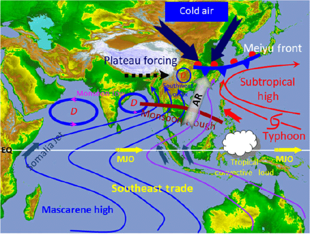
One key feature is that our AR analysis focused on the tropical–subtropical interactions within a monsoon climate, in which ARs can be generally wider and less filamentary, as compared to the ARs in extratropical areas (Waliser and Guan 2017). This is illustrated in a schematic diagram in Fig. 7, which shows ARs in the Asian monsoon context. Firstly, in the Asian monsoon system, the Iranian and Tibetan plateaus act as a dynamical blocking of the low-level Somali jet stream (Boos and Kuang 2010). At the same time, the surface elevated heating favours the formation of large-scale monsoon vortex and cyclonic flows surrounding the Tibetan Plateau (Wu and Liu 2016). Both factors contribute to the establishment of south-westerly monsoon flow, which penetrates from the tropical South Asia into the subtropical East Asia.
|
Another dominant process influencing the East Asian summer monsoon and its moisture transport is the WPSH. ARs in the Asian monsoon system act as carriers for moisture along the preferred channels in the Asian monsoon background. Within these channels, there are pulses of ARs supplying tropical warm and moist air to the extratropical monsoon region. This is different from AR studies in other regions, which focused on how moisture from the tropics is transported into the midlatitude cyclonic systems to produce heavy rainfall events over mountainous coastal areas (e.g. Ralph et al. 2006; Dettinger et al. 2011; Lavers et al. 2012; Mahoney et al. 2016; Zhang et al. 2019; Mo et al. 2019). A recent case study by Mo and Lin (2019) showed a similar influence of the subtropical high in the western Atlantic on a winter AR across central and eastern North America.
Furthermore, our AR analysis in the Australian region focused on documenting what the role of AR is in the formation of the NWCB, a key synoptic feature influencing Australian rainfall variations (Tapp and Barrell 1984; Wright 1997). In this project, we explored the connections between ARs and NWCBs and used backward trajectory analysis to explore the moisture source of ARs and found that moisture originating from the tropical Indian Ocean is very important for rainfall generation in the interior of the Australian continent associated with NWCBs (Chen et al. 2020; Wu et al. 2020). Furthermore, the analysis by Wu et al. (2020) has shown that when NWCB is supported by an AR, it is more likely to produce heavy rainfall. This explains why NWCBs do not always produce heavy rainfall during their passages, as some of the cloud bands are associated with the condensation of midlatitude air masses rather than the warm and moist air transported by ARs from the tropics (which is more rainfall efficient).
Our analysis also proposed a potential linkage between ARs occurring almost simultaneously in the East Asian summer monsoon in Australia (austral winter). Xu et al. (2020a) termed these as ‘AR bifurcation’, with one branch of the warm and moist air over the tropical oceans being transported into the East Asian region through an AR embedded within the summer Asian monsoon and another branch penetrating into the Australian continent. They found that most of the AR bifurcations occurred during the boreal summer following the decaying phase of an El Niño in its preceding winter, and they attributed such connections to the influence of tropical SSTs on modulating the positions and intensities of WPSH and SPCZ. Nevertheless, much more research is needed to further consolidate the results from this project and uncover the underlying reasons.
Overall, results from this collaborative project have demonstrated the scientific benefits of applying AR analysis in the A-A region to achieve better rainfall forecasts at NWP, subseasonal and seasonal time scales. There are many important aspects of the ARs occurring in the A-A region that warrant further detailed studies. Although Dong (2018) and Liang et al. (2020) discussed the application of ARs in supporting seasonal and subseasonal precipitation forecasts in the Asian monsoon region, more analyses are needed to assess such potential using operational coupled seasonal forecasting products, such as in the work by DeFlorio et al. (2018) and Nardi et al. (2018). Based on the dataset produced by manual AR detection, we also plan to develop or select automatic AR detection algorithms applicable in the A-A region. This will allow us to conduct AR-based diagnoses to support operational rainfall forecasts based on the NWP guidance and/or other seasonal forecasting models.
Finally, we will further expand our AR analysis in some climate change projection studies (e.g. Ramos et al. 2016; Espinoza et al. 2018). This is a very important research topic in the A-A region because there are competing effects of global warming on ARs: warmed tropical oceans against changes in monsoon circulation. While global SST warming provides more abundant tropical moisture sources through enhanced oceanic evaporation, the monsoon circulation responses to global warming can be very complex (Zhang et al. 2012, 2013, 2016; Dong et al. 2016; Zhao and Zhang 2016). Following the work by Xu et al. (2020b), more detailed AR analysis will help to understand and narrow down uncertainty in regional climate change projections in the A-A region, and the BoM-CMA collaboration will continue to make contributions in this regard.
Conflicts of interest
The authors declare no conflicts of interest.
Acknowledgments
The authors would like to thank the BoM and CMA for the agreement and support of this bilateral research project. The discussions with Drs. H. Hendon (BoM), B. Guan and D. Waliser of JPL, and G. Martin and Peili Wu of UKMO, are highly acknowledged. Dr. Zuqiang Zhang of CMA provided a draft version of Fig. 7. We also thank the constructive comments from Drs. Greg Roff, Vinod Kumar and Gabrielle Gascon during the internal review process. Comments and suggestions from two anonymous reviewers have considerably improved the manuscript. This research is supported by a BoM-CMA collaborative project (JWG–16 4.1). The participation of CMA scientists is supported by a National Key R & D Program of China (2018YFC1507200) and a Key Scientific Research Project of Hunan Meteorological Bureau (XQKJ16A001, XQKJ17D001).
References
American Meteorological Society (2019 ). Atmospheric River. Glossary of Meteorology. Available at http://glossary.ametsoc.org/wiki/Atmospheric_river.Bao, J.-W., Michelson, S. A., Neiman, P. J., Ralph, F. M., and Wilczak, J. M. (2006). Interpretation of enhanced integrated water vapor bands associated with extratropical cyclones: Their formation and connection to tropical moisture. Mon. Wea. Rev. 134, 1063–1080.
| Interpretation of enhanced integrated water vapor bands associated with extratropical cyclones: Their formation and connection to tropical moisture.Crossref | GoogleScholarGoogle Scholar |
Benton, G. S., and Estoque, M. A. (1954). Water-vapor transfer over the North American continent. J. Meteor. 11, 462–477.
| Water-vapor transfer over the North American continent.Crossref | GoogleScholarGoogle Scholar |
Boos, W. R., and Kuang, Z. M. (2010). Dominant control of the South Asian monsoon by orographic insulation versus plateau heating. Nature 463, 218–223.
Browning, K. (2018). Atmospheric rivers in the U.K. Bull. Am. Meteor. Soc. 99, 1108–1109.
| Atmospheric rivers in the U.K.Crossref | GoogleScholarGoogle Scholar |
Cai, W., van Rensch, P., Cowan, T., and Hendon, H. H. (2011). Teleconnection pathways of ENSO and the IOD and the mechanisms for impacts on Australian rainfall. J. Climate 24, 3910–3923.
| Teleconnection pathways of ENSO and the IOD and the mechanisms for impacts on Australian rainfall.Crossref | GoogleScholarGoogle Scholar |
Chang, C. P., Harr, P. A., McBride, J. and Hsu, H.-H. (2004). Maritime Continent monsoon: Annual cycle and boreal winter variability. In ‘East Asian Monsoon.’ (Ed. C.-P. Chang.) pp. 107–150. (World Scientific: Singapore.)
Chen, J., Zhang, H., Ye, C., Chen, H., and Mo, R. (2020). Case studies of atmospheric rivers over China and Australia: new insight into their rainfall generation. J. South. Hemisph. Earth Syst. Sci , .
| Case studies of atmospheric rivers over China and Australia: new insight into their rainfall generation.Crossref | GoogleScholarGoogle Scholar |
Chen, L., Zhu, Q. and Luo, H. (1991). ‘East Asian Monsoon.’ (China Meteorological Press: Beijing). 362 pp. [In Chinese].
Chen, M., Shi, W., Xie, P., Silva, V. B., Kousky, V. E., Higgins, R. W., and Janowiak, J. E. (2008). Assessing objective techniques for gauge-based analyses of global daily precipitation. J. Geophys. Res. Atmos. 113, D04110.
| Assessing objective techniques for gauge-based analyses of global daily precipitation.Crossref | GoogleScholarGoogle Scholar |
DeFlorio, M. J., Waliser, D. E., Guan, B., Lavers, D. A., Ralph, F. M., and Vitart, F. (2018). Global assessment of atmospheric river prediction skill. J. Hydrometeor. 19, 409–426.
| Global assessment of atmospheric river prediction skill.Crossref | GoogleScholarGoogle Scholar |
Dettinger, M. D., Ralph, F. M., Das, T., Neiman, P. J., and Cayan, D. R. (2011). Atmospheric rivers, floods and the water resources of California. Water 3, 445–478.
| Atmospheric rivers, floods and the water resources of California.Crossref | GoogleScholarGoogle Scholar |
Dettinger, M., Ralph, F. M., and Lavers, D. (2015). Setting the stage for a global science of atmopsheric rivers. Eos, Trans. Amer. Geophys. Union 96, .
| Setting the stage for a global science of atmopsheric rivers.Crossref | GoogleScholarGoogle Scholar |
Ding, Y. (1994). ‘Monsoons over China.’ (Springer Science+Business Media: Dordrecht) 420 pp
Ding, Y. (2004). Seasonal march of the East-Asian summer monsoon. In ‘East Asian Monsoon.’ (Ed. C.-P. Chang.) pp. 3–53. (World Scientific: Singapore.)
Dirmeyer, P. A., and Kinter, J. L. (2009). The “Maya Express”: Floods in the US Midwest. Eos, Trans. Amer. Geophys. Union 90, 101–102.
| The “Maya Express”: Floods in the US Midwest.Crossref | GoogleScholarGoogle Scholar |
Dong, G. (2018). East Asian monsoon forecast skill in ACCESS-S1 and sensitivity to land-surface initial conditions. Abstracts for Australian Meteorological and Oceanographic Society-International Conference on Southern Hemisphere Meteorology and Oceanography, 5–9 February, 2018, Sydney, Australia.
Dong, G., Zhang, H., Moise, A., Hanson, L., Liang, P., and Ye, H. (2016). CMIP5 model-simulated onset, duration and intensity of the Asian summer monsoon in current and future climate. Climate Dyn. 46, 355–382.
| CMIP5 model-simulated onset, duration and intensity of the Asian summer monsoon in current and future climate.Crossref | GoogleScholarGoogle Scholar |
Espinoza, V., Waliser, D. E., Guan, B., Lavers, D. A., and Ralph, F. M. (2018). Global analysis of climate change projection effects on atmospheric rivers. Geophys. Res. Lett. 45, 4299–4308.
| Global analysis of climate change projection effects on atmospheric rivers.Crossref | GoogleScholarGoogle Scholar |
Frederiksen, C. S., and Balgovind, R. C. (1994). The influence of the Indian Ocean/Indonesian SST gradient on the Australian winter rainfall and circulation in an atmospheric GCM. Quart. J. Roy. Meteor. Soc. 120, 923–952.
| The influence of the Indian Ocean/Indonesian SST gradient on the Australian winter rainfall and circulation in an atmospheric GCM.Crossref | GoogleScholarGoogle Scholar |
Frederiksen, C. S., and Frederiksen, J. S. (1996). A theoretical model of Australian Northwest Cloudband disturbances and Southern Hemisphere storm tracks: The role of SST anomalies. J. Atmos. Sci. 53, 1410–1432.
| A theoretical model of Australian Northwest Cloudband disturbances and Southern Hemisphere storm tracks: The role of SST anomalies.Crossref | GoogleScholarGoogle Scholar |
Frederiksen, C. S., Zheng, X., and Grainger, S. (2014). Teleconnections and predictive characteristics of Australian seasonal rainfall. Climate Dyn. 43, 1381–1408.
| Teleconnections and predictive characteristics of Australian seasonal rainfall.Crossref | GoogleScholarGoogle Scholar |
Garreaud, R. (2013). Warm winter storms in central Chile. J. Hydrometeor. 14, 1515–1534.
| Warm winter storms in central Chile.Crossref | GoogleScholarGoogle Scholar |
Gershunov, A., Shulgina, T., Ralph, F. M., Lavers, D. A., and Rutz, J. J. (2017). Assessing the climate-scale variability of atmospheric rivers affecting western North America. Geophys. Res. Lett. 44, 7900–7908.
| Assessing the climate-scale variability of atmospheric rivers affecting western North America.Crossref | GoogleScholarGoogle Scholar |
Gershunov, A., Shulgina, T., Clemesha, R. E. S., Guirguis, K., Pierce, D. W., Dettinger, M. D., Lavers, D. A., Cayan, D. R., Polade, S. D., Kalansky, J., and Ralph, F. M. (2019). Precipitation regime change in western North America: The role of atmospheric rivers. Sci. Rep. 9, 9944.
| Precipitation regime change in western North America: The role of atmospheric rivers.Crossref | GoogleScholarGoogle Scholar | 31289295PubMed |
Gimeno, L., Dominguez, F., Nieto, R., Trigo, R., Drumond, A., Reason, C. J. C., Taschetto, A. S., Ramos, A. M., Kumar, R., and Marengo, J. (2016). Major mechanisms of atmospheric moisture transport and their role in extreme precipitation events. Annu. Rev. Environ. Resour. 41, 117–141.
| Major mechanisms of atmospheric moisture transport and their role in extreme precipitation events.Crossref | GoogleScholarGoogle Scholar |
Gimeno, L., Nieto, R., Vázquez, M., and Lavers, D. A. (2014). Atmospheric rivers: a mini-review. Front. Earth Sci. 2, 2.
| Atmospheric rivers: a mini-review.Crossref | GoogleScholarGoogle Scholar |
Guan, B., and Waliser, D. E. (2015). Detection of atmospheric rivers: Evaluation and application of an algorithm for global studies. J. Geophys. Res. Atmos. 120, 12514–12535.
| Detection of atmospheric rivers: Evaluation and application of an algorithm for global studies.Crossref | GoogleScholarGoogle Scholar |
Guan, B., Molotch, N. P., Waliser, D. E., Fetzer, E. J., and Neiman, P. J. (2010). Extreme snowfall events linked to atmospheric rivers and surface air temperature via satellite measurements. Geophys. Res. Lett. 37, L20401.
| Extreme snowfall events linked to atmospheric rivers and surface air temperature via satellite measurements.Crossref | GoogleScholarGoogle Scholar |
Gyakum, J. R. (2000). Moisture transport to Arctic drainage basins relating to significant precipitation events and cyclogenesis. In ‘The Freshwater Budget of the Arctic Ocean. NATO Science Series (Series 2. Environment Security), vol 70.’ (Eds E. L. Lewis, E. P. Jones, P. Lemke, T. D. Prowse and P. Wadhams.) pp. 1997–208. (Springer: Dordrecht)
Harada, Y., Kamahori, H., Kobayashi, C., Endo, H., Kobayashi, S., Ota, Y., Onoda, H., Onogi, K., Miyaoka, K., and Takahashi, K. (2016). The JRA-55 Reanalysis: Representation of atmospheric circulation and climate variability. J. Meteor. Soc. Japan 94, 269–302.
| The JRA-55 Reanalysis: Representation of atmospheric circulation and climate variability.Crossref | GoogleScholarGoogle Scholar |
He, J., Sun, C., Liu, Y., Matsumoto, J., and Li, W. (2007). Seasonal transition features of large-scale moisture transport in the Asian-Australian monsoon region. Adv. Atmos. Sci. 24, 1–14.
| Seasonal transition features of large-scale moisture transport in the Asian-Australian monsoon region.Crossref | GoogleScholarGoogle Scholar |
Hill, H. W. (1964). The weather in lower latitudes of the southwest Pacific associated with the passage of disturbances in the middle-latitude westerlies. In: ‘Proceedings, Symposium on Tropical Meteorology. Rotorua, New Zealand, 5–13 November 1963’. (Ed. J. W. Hutchings). New Zealand Meteorological Service, Wellington.
Hill, H. W. (1969). A synoptic study of a large-scale meridional trough in the Tasman Sea–New Zealand area. New Zealand J. Sci. 12, 576–593.
Hill, H. W. (1977). The structure and development of major weather systems in the Australian region. In: Conference Handbook, Two-Day Workshop on Fronts. 26–27 May 1977, Bureau of Meteorology, Melbourne, Chapter 2, 8 pp.
Hirota, N., Takayabu, Y. N., Kato, M., and Arakane, S. (2016). Roles of an atmospheric river and a cutoff low in the extreme precipitation event in Hiroshima on 19 August 2014. Mon. Wea. Rev. 144, 1145–1160.
| Roles of an atmospheric river and a cutoff low in the extreme precipitation event in Hiroshima on 19 August 2014.Crossref | GoogleScholarGoogle Scholar |
Joseph, B., and Moustaoui, M. (2000). Transport, moisture, and rain in a simple monsoonlike flow. J. Atmos. Sci. 57, 1817–1838.
| Transport, moisture, and rain in a simple monsoonlike flow.Crossref | GoogleScholarGoogle Scholar |
Knippertz, P., and Wernli, H. (2010). A Lagrangian climatology of tropical moisture exports to the Northern Hemispheric extratropics. J. Climate 23, 987–1003.
| A Lagrangian climatology of tropical moisture exports to the Northern Hemispheric extratropics.Crossref | GoogleScholarGoogle Scholar |
Kobayashi, S., Ota, Y., Harada, Y., Ebita, A., Moriya, M., Onoda, H., Onogi, K., Kamahori, H., Kobayashi, C., and Endo, H. (2015). The JRA-55 reanalysis: General specifications and basic characteristics. J. Meteor. Soc. Japan 93, 5–48.
| The JRA-55 reanalysis: General specifications and basic characteristics.Crossref | GoogleScholarGoogle Scholar |
Lackmann, G. M., and Gyakum, J. R. (1999). Heavy cold-season precipitation in the northwestern United States: Synoptic climatology and an analysis of the flood of 17–18 January 1986. Wea. Forecasting 14, 687–700.
| Heavy cold-season precipitation in the northwestern United States: Synoptic climatology and an analysis of the flood of 17–18 January 1986.Crossref | GoogleScholarGoogle Scholar |
Lavers, D. A., Allan, R. P., Wood, E. F., Villarini, G., Brayshaw, D. J., and Wade, A. J. (2011). Winter floods in Britain are connected to atmospheric rivers. Geophys. Res. Lett. 38, L23803.
| Winter floods in Britain are connected to atmospheric rivers.Crossref | GoogleScholarGoogle Scholar |
Lavers, D. A., and Villarini, G. (2013). The nexus between atmospheric rivers and extreme precipitation across Europe. Geophys. Res. Lett. 40, 3259–3264.
| The nexus between atmospheric rivers and extreme precipitation across Europe.Crossref | GoogleScholarGoogle Scholar |
Lavers, D. A., and Villarini, G. (2015). The contributions of atmospheric rivers to precipitation in Europe and the United States. J. Hydrol. 522, 382–390.
| The contributions of atmospheric rivers to precipitation in Europe and the United States.Crossref | GoogleScholarGoogle Scholar |
Lavers, D. A., Villarini, G., Allan, R. P., Wood, E. F., and Wade, A. J. (2012). The detection of atmospheric rivers in atmospheric reanalyses and their links to British winter floods and the large‐scale climatic circulation. J. Geophys. Res. Atmos. 117, D20106.
| The detection of atmospheric rivers in atmospheric reanalyses and their links to British winter floods and the large‐scale climatic circulation.Crossref | GoogleScholarGoogle Scholar |
Liang, P., Dong, G., Zhang, H., Zhao, M., and Ma, Y. (2020). Atmospheric rivers associated with summer heavy rainfall over the Yangtze Plain. J. South. Hemisph. Earth Syst. Sci , .
| Atmospheric rivers associated with summer heavy rainfall over the Yangtze Plain.Crossref | GoogleScholarGoogle Scholar |
Mahoney, K., Jackson, D. L., Neiman, P., Hughes, M., Darby, L., Wick, G., White, A., Sukovich, E., and Cifelli, R. (2016). Understanding the role of atmospheric rivers in heavy precipitation in the southeast United States. Mon. Wea. Rev. 144, 1617–1632.
| Understanding the role of atmospheric rivers in heavy precipitation in the southeast United States.Crossref | GoogleScholarGoogle Scholar |
Mo, R., Brugman, M. M., Milbrandt, J. A., Goosen, J., Geng, Q., Emond, C., Bau, J., and Erfani, A. (2019). Impacts of hydrometeor drift on orographic precipitation: Two case studies of landfalling atmospheric rivers in British Columbia, Canada. Wea. Forecasting 34, 1211–1237.
| Impacts of hydrometeor drift on orographic precipitation: Two case studies of landfalling atmospheric rivers in British Columbia, Canada.Crossref | GoogleScholarGoogle Scholar |
Mo, R., Geng, Q., Brugman, M., Pearce, G., Goosen, J. and Snyder, B. (2009). Collision of a Pineapple Express with an arctic outbreak over complex terrains of British Columbia, Canada – Forecast challenges and lessons learned. 23rd Conference on Weather Analysis and Forecasting, 1-5 June 2009 Omaha, NE, USA. American Meteorological Society, 10B.2. Available at https://ams.confex.com/ams/pdfpapers/154212.pdf.
Mo, R., and Lin, H. (2019). Tropical–mid-latitude interactions: Case study of an inland-penetrating atmospheric river during a major winter storm over North America. Atmos.-Ocean 57, 208–232.
| Tropical–mid-latitude interactions: Case study of an inland-penetrating atmospheric river during a major winter storm over North America.Crossref | GoogleScholarGoogle Scholar |
Nardi, K. M., Barnes, E. A., and Ralph, F. M. (2018). Assessment of numerical weather prediction model reforecasts of the occurrence, intensity, and location of atmospheric rivers along the West Coast of North America. Mon. Wea. Rev. 146, 3343–3362.
| Assessment of numerical weather prediction model reforecasts of the occurrence, intensity, and location of atmospheric rivers along the West Coast of North America.Crossref | GoogleScholarGoogle Scholar |
Neiman, P. J., Ralph, F. M., Wick, G. A., Lundquist, J. D., and Dettinger, M. D. (2008a). Meteorological characteristics and overland precipitation impacts of atmospheric rivers affecting the West Coast of North America based on eight years of SSM/I satellite observations. J. Hydrometeor. 9, 22–47.
| Meteorological characteristics and overland precipitation impacts of atmospheric rivers affecting the West Coast of North America based on eight years of SSM/I satellite observations.Crossref | GoogleScholarGoogle Scholar |
Neiman, P. J., Ralph, F. M., Wick, G. A., Kuo, Y.-H., Wee, T.-K., Ma, Z., Taylor, G. H., and Dettinger, M. D. (2008b). Diagnosis of an intense atmospheric river impacting the Pacific Northwest: Storm summary and offshore vertical structure observed with COSMIC satellite retrievals. Mon. Wea. Rev. 136, 4398–4420.
| Diagnosis of an intense atmospheric river impacting the Pacific Northwest: Storm summary and offshore vertical structure observed with COSMIC satellite retrievals.Crossref | GoogleScholarGoogle Scholar |
Newell, R. E., Newell, N. E., Zhu, Y., and Scott, C. (1992). Tropospheric rivers?–A pilot study. Geophys. Res. Lett. 19, 2401–2404.
| Tropospheric rivers?–A pilot study.Crossref | GoogleScholarGoogle Scholar |
Newell, R. E., and Zhu, Y. (1994). Tropospheric rivers: A one-year record and a possible application to ice core data. Geophys. Res. Lett. 21, 113–116.
| Tropospheric rivers: A one-year record and a possible application to ice core data.Crossref | GoogleScholarGoogle Scholar |
Newman, M., Kiladis, G. N., Weickmann, K. M., Ralph, F. M., and Sardeshmukh, P. D. (2012). Relative contributions of synoptic and low-frequency eddies to time-mean atmospheric moisture transport, including the role of atmospheric rivers. J. Climate 25, 7341–7361.
| Relative contributions of synoptic and low-frequency eddies to time-mean atmospheric moisture transport, including the role of atmospheric rivers.Crossref | GoogleScholarGoogle Scholar |
NOAA (2019). CPC global unified gauge-based analysis of daily precipitation. Available at https://www.esrl.noaa.gov/psd/data/gridded/data.cpc.globalprecip.html.
Paltan, H., Waliser, D., Lim, W. H., Guan, B., Yamazaki, D., Pant, R., and Dadson, S. (2017). Global floods and water availability driven by atmospheric rivers. Geophys. Res. Lett. 44, .
| Global floods and water availability driven by atmospheric rivers.Crossref | GoogleScholarGoogle Scholar |
Ralph, F. M., and Dettinger, M. D. (2012). Historical and national perspectives on extreme West Coast precipitation associated with atmospheric rivers during December 2010. Bull. Am. Meteor. Soc. 93, 783–790.
| Historical and national perspectives on extreme West Coast precipitation associated with atmospheric rivers during December 2010.Crossref | GoogleScholarGoogle Scholar |
Ralph, F. M., Neiman, P. J., and Wick, G. A. (2004). Satellite and CALJET aircraft observations of atmospheric rivers over the eastern North Pacific Ocean during the winter of 1997/98. Mon. Wea. Rev. 132, 1721–1745.
| Satellite and CALJET aircraft observations of atmospheric rivers over the eastern North Pacific Ocean during the winter of 1997/98.Crossref | GoogleScholarGoogle Scholar |
Ralph, F. M., Neiman, P. J., and Rotunno, R. (2005). Dropsonde observations in low-level jets over the northeastern Pacific Ocean from CALJET–1998 and PACJET-2001: Mean vertical-profile and atmospheric-river characteristics. Mon. Wea. Rev. 133, 889–910.
| Dropsonde observations in low-level jets over the northeastern Pacific Ocean from CALJET–1998 and PACJET-2001: Mean vertical-profile and atmospheric-river characteristics.Crossref | GoogleScholarGoogle Scholar |
Ralph, F. M., Neiman, P. J., Kiladis, G. N., Weickmann, K., and Reynolds, D. W. (2011). A multi-scale observational case study of a Pacific atmospheric river exhibiting tropical-extratropical connections and a mesoscale frontal wave. Mon. Wea. Rev. 139, 1169–1189.
| A multi-scale observational case study of a Pacific atmospheric river exhibiting tropical-extratropical connections and a mesoscale frontal wave.Crossref | GoogleScholarGoogle Scholar |
Ralph, F. M., Neiman, P. J., Wick, G. A., Gutman, S. I., Dettinger, M. D., Cayan, D. R., and White, A. B. (2006). Flooding on California’s Russian River: Role of atmospheric rivers. Geophys. Res. Lett. 33, L13801.
| Flooding on California’s Russian River: Role of atmospheric rivers.Crossref | GoogleScholarGoogle Scholar |
Ralph, F. M., Dettinger, M., Lavers, D., Gorodetskaya, I. V., Martin, A., Viale, M., White, A. B., Oakley, N., Rutz, J., and Spackman, J. R. (2017). Atmospheric rivers emerge as a global science and applications focus. Bull. Am. Meteor. Soc. 98, 1969–1973.
| Atmospheric rivers emerge as a global science and applications focus.Crossref | GoogleScholarGoogle Scholar |
Ramos, A. M., Tomé, R., Trigo, R. M., Liberato, M. L. R., and Pinto, J. G. (2016). Projected changes in atmospheric rivers affecting Europe in CMIP5 models. Geophys. Res. Lett. 43, 9315–9323.
| Projected changes in atmospheric rivers affecting Europe in CMIP5 models.Crossref | GoogleScholarGoogle Scholar |
Risbey, J. S., Pook, M. J., McIntosh, P. C., Ummenhofer, C. C., and Meyers, G. (2009a). Characteristics and variability of synoptic features associated with cool season rainfall in southeastern Australia. Int. J. Climatol. 29, 1595–1613.
| Characteristics and variability of synoptic features associated with cool season rainfall in southeastern Australia.Crossref | GoogleScholarGoogle Scholar |
Risbey, J. S., Pook, M. J., McIntosh, P. C., Wheeler, M. C., and Hendon, H. H. (2009b). On the remote drivers of rainfall variability in Australia. Mon. Wea. Rev. 137, 3233–3253.
| On the remote drivers of rainfall variability in Australia.Crossref | GoogleScholarGoogle Scholar |
Roberge, A., Gyakum, J. R., and Atallah, E. H. (2009). Analysis of intense poleward water vapor transports into high latitudes of western North America. Wea. Forecasting 24, 1732–1747.
| Analysis of intense poleward water vapor transports into high latitudes of western North America.Crossref | GoogleScholarGoogle Scholar |
Shields, C. A., and Coauhthors, (2018). Atmospheric River tracking method intercomparison project (ARTMIP): Project goals and experimental design. Geosci. Model Dev. 11, 2455–2474.
| Atmospheric River tracking method intercomparison project (ARTMIP): Project goals and experimental design.Crossref | GoogleScholarGoogle Scholar |
Smirnov, V. V., and Moore, G. W. K. (1999). Spatial and temporal structure of atmospheric water vapor transport in the Mackenzie River basin. J. Climate 12, 681–696.
| Spatial and temporal structure of atmospheric water vapor transport in the Mackenzie River basin.Crossref | GoogleScholarGoogle Scholar |
Smith, B. L., Yuter, S. E., Neiman, P. J., and Kingsmill, D. E. (2010). Water vapor fluxes and orographic precipitation over northern California associated with a landfalling atmospheric river. Mon. Wea. Rev. 138, 74–100.
| Water vapor fluxes and orographic precipitation over northern California associated with a landfalling atmospheric river.Crossref | GoogleScholarGoogle Scholar |
Sodemann, H., and Stohl, A. (2013). Moisture origin and meridional transport in atmospheric rivers and their association with multiple cyclones. Mon. Wea. Rev. 141, 2850–2868.
| Moisture origin and meridional transport in atmospheric rivers and their association with multiple cyclones.Crossref | GoogleScholarGoogle Scholar |
Tapp, R. G., and Barrell, S. L. (1984). The north-west Australian cloud band: Climatology, characteristics and factors associated with development. J. Climatol. 4, 411–424.
| The north-west Australian cloud band: Climatology, characteristics and factors associated with development.Crossref | GoogleScholarGoogle Scholar |
Ummenhofer, C. C., England, M. H., McIntosh, P. C., Meyers, G. A., Pook, M. J., Risbey, J. S., Sen Gupta, A., and Taschetto, A. S. (2009). What causes southeast Australia’s worst droughts? Geophy. Res. Lett. 36, L04706.
| What causes southeast Australia’s worst droughts?Crossref | GoogleScholarGoogle Scholar |
Ummenhofer, C. C., Sen Gupta, A., Briggs, P. R., England, M. H., McIntosh, P. C., Meyers, G. A., Pook, M. J., Raupach, M. R., and Risbey, J. S. (2011). Indian and Pacific Ocean influences on southeast Australian drought and soil moisture. J. Climate 24, 1313–1336.
| Indian and Pacific Ocean influences on southeast Australian drought and soil moisture.Crossref | GoogleScholarGoogle Scholar |
Van der Ent, R. J., Savenije, H. H. G., Schaefli, B., and Steele-Dunne, S. C. (2010). Origin and fate of atmospheric moisture over continents. Water Resour. Res. 46, W09525.
| Origin and fate of atmospheric moisture over continents.Crossref | GoogleScholarGoogle Scholar |
Viale, M., Valenzuela, R., Garreaud, R. D., and Ralph, F. M. (2018). Impacts of atmospheric rivers on precipitation in southern South America. J. Hydrometeor. 19, 1671–1687.
| Impacts of atmospheric rivers on precipitation in southern South America.Crossref | GoogleScholarGoogle Scholar |
Waliser, D. E., and Guan, B. (2017). Extreme winds and precipitation during landfall of atmospheric rivers. Nat. Geosci. 10, 179–183.
| Extreme winds and precipitation during landfall of atmospheric rivers.Crossref | GoogleScholarGoogle Scholar |
Wang, B. (2006). The Asian monsoon. (Springer-Praxis Publishing Ltd.: Chichester.) 787 pp.
Wang, B., Xiang, B., and Lee, J.-Y. (2013). Subtropical High predictability establishes a promising way for monsoon and tropical storm predictions. Proc. Nat. Acad. Sci. USA 110, 2718–2722.
| Subtropical High predictability establishes a promising way for monsoon and tropical storm predictions.Crossref | GoogleScholarGoogle Scholar | 23341624PubMed |
Warner, M. D., Mass, C. F., and Salathé, E. P. (2012). Wintertime extreme precipitation events along the Pacific Northwest coast: Climatology and synoptic evolution. Mon. Wea. Rev. 140, 2021–2043.
| Wintertime extreme precipitation events along the Pacific Northwest coast: Climatology and synoptic evolution.Crossref | GoogleScholarGoogle Scholar |
Warner, M. D., Mass, C. F., and Salathé, E. P. (2015). Changes in winter atmospheric rivers along the North American west coast in CMIP5 climate models. J. Hydrometeor. 16, 118–128.
| Changes in winter atmospheric rivers along the North American west coast in CMIP5 climate models.Crossref | GoogleScholarGoogle Scholar |
Wick, G. A. (2014). Implementation and initial application of an atmospheric river detection tool based on integrated vapor transport. 2014 Fall Meeting, San Francisco, CA, USA. Amer. Geophys. Union, Abstract A34E-06.
Wick, G. A., Neiman, P. J., and Ralph, F. M. (2013). Description and validation of an automated objective technique for identification and characterization of the integrated water vapor signature of atmospheric rivers. IEEE Trans. Geosci. Remote Sens. 51, 2166–2176.
| Description and validation of an automated objective technique for identification and characterization of the integrated water vapor signature of atmospheric rivers.Crossref | GoogleScholarGoogle Scholar |
Wright, W. J. (1997). Tropical-extratropical cloudbands and Australian rainfall: I. Climatology. Int. J. Climatol. 17, 807–829.
| Tropical-extratropical cloudbands and Australian rainfall: I. Climatology.Crossref | GoogleScholarGoogle Scholar |
Wu, G., and Liu, Y. (2016). Impacts of the Tibetan Plateau on Asian climate. Meteorological Monographs 56, 7.1–7.29.
| Impacts of the Tibetan Plateau on Asian climate.Crossref | GoogleScholarGoogle Scholar |
Wu, X., Ye, C., He, W., Chen, J., Xu, L., and Zhang, H. (2020). Atmospheric rivers impacting mainland China and Australia: climatology and interannual variations. J. South. Hemisph. Earth Syst. Sci , .
| Atmospheric rivers impacting mainland China and Australia: climatology and interannual variations.Crossref | GoogleScholarGoogle Scholar |
Xu, Y. (2018). The anthropogenic contribution to Asia-Australia monsoon system changes. Abstracts for Australian Meteorological and Oceanographic Society-International Conference on Southern Hemisphere Meteorology and Oceanography, 5–9 February, 2018, Sydney, Australia.
Xu, L., Zhang, H., He, W., Ye, C., and Moise, A. (2020a). Potential connections between atmospheric rivers in China and Australia. J. South. Hemisph. Earth Syst. Sci , .
| Potential connections between atmospheric rivers in China and Australia.Crossref | GoogleScholarGoogle Scholar |
Xu, Y., Zhang, H., Liu, Y., Han, Z., and Zhou, B. (2020b). Atmospheric rivers in the Australia–Asian region under current and future climate in CMIP5 models. J. South. Hemisph. Earth Syst. Sci
Yang, Y., Zhao, T., Ni, G., and Sun, T. (2018). Atmospheric rivers over the Bay of Bengal lead to northern Indian extreme rainfall. Int. J. Climatol. 38, 1010–1021.
| Atmospheric rivers over the Bay of Bengal lead to northern Indian extreme rainfall.Crossref | GoogleScholarGoogle Scholar |
Ying, K., Zheng, X., Zhao, T., Frederiksen, C. S., and Quan, X.-W. (2017). Identifying the predictable and unpredictable patterns of spring-to-autumn precipitation over eastern China. Climate Dyn. 48, 3183–3206.
| Identifying the predictable and unpredictable patterns of spring-to-autumn precipitation over eastern China.Crossref | GoogleScholarGoogle Scholar |
Zhang, H. (2010). Diagnosing Australia-Asian monsoon onset/retreat using large-scale wind and moisture indices. Climate Dyn. 35, 601–618.
| Diagnosing Australia-Asian monsoon onset/retreat using large-scale wind and moisture indices.Crossref | GoogleScholarGoogle Scholar |
Zhang, H., Liang, P., Moise, A., and Hanson, L. (2012). Diagnosing potential changes in Asian summer monsoon onset and duration in IPCC AR4 model simulations using moisture and wind indices. Climate Dyn. 39, 2465–2486.
| Diagnosing potential changes in Asian summer monsoon onset and duration in IPCC AR4 model simulations using moisture and wind indices.Crossref | GoogleScholarGoogle Scholar |
Zhang, H., Moise, A., Liang, P., and Hanson, L. (2013). The response of summer monsoon onset/retreat in Sumatra-Java and tropical Australia region to global warming in CMIP3 models. Climate Dyn. 40, 377–399.
| The response of summer monsoon onset/retreat in Sumatra-Java and tropical Australia region to global warming in CMIP3 models.Crossref | GoogleScholarGoogle Scholar |
Zhang, H., Dong, G., Moise, A., Colman, R., Hanson, L., and Ye, H. (2016). Uncertainty in CMIP5 model-projected changes in the onset/retreat of the Australian summer monsoon. Climate Dyn. 46, 2371–2389.
| Uncertainty in CMIP5 model-projected changes in the onset/retreat of the Australian summer monsoon.Crossref | GoogleScholarGoogle Scholar |
Zhang, Z., Ralph, F. M., and Zheng, M. (2019). The relationship between extratropical cyclone strength and atmospheric river intensity and position. Geophys. Res. Lett. 46, 1814–1823.
| The relationship between extratropical cyclone strength and atmospheric river intensity and position.Crossref | GoogleScholarGoogle Scholar |
Zhao, Y., and Zhang, H. (2016). Impacts of SST warming in tropical Indian Ocean on CMIP5 model-projected summer rainfall changes over Central. Asia. Climate Dyn. 46, 3223–3238.
| Impacts of SST warming in tropical Indian Ocean on CMIP5 model-projected summer rainfall changes over Central.Crossref | GoogleScholarGoogle Scholar |
Zhu, Y., and Newell, R. E. (1994). Atmospheric rivers and bombs. Geophys. Res. Lett. 21, 1999–2002.
| Atmospheric rivers and bombs.Crossref | GoogleScholarGoogle Scholar |
Zhu, Y., and Newell, R. E. (1998). A proposed algorithm for moisture fluxes from atmospheric rivers. Mon. Wea. Rev. 126, 725–735.
| A proposed algorithm for moisture fluxes from atmospheric rivers.Crossref | GoogleScholarGoogle Scholar |