
The warm and extremely dry spring in 2015 in Tasmania contained the fingerprint of human influence on the climate
Michael R. Grose A E , Mitchell T. Black B , Guomin Wang B , Andrew D. King C , Pandora Hope B and David J. Karoly DA CSIRO Marine Laboratories, Castray Esplanade, Hobart, Tas. 7000, Australia.
B Research and Development, Bureau of Meteorology, Melbourne, Vic., Australia.
C School of Earth Sciences and ARC Centre of Excellence for Climate System Science, University of Melbourne, Melbourne, Vic., Australia.
D CSIRO Oceans and Atmosphere, Aspendale, Vic., Australia.
E Corresponding author. Email: michael.grose@csiro.au
Journal of Southern Hemisphere Earth Systems Science 69(1) 183-195 https://doi.org/10.1071/ES19011
Submitted: 13 June 2017 Accepted: 26 July 2019 Published: 11 June 2020
Journal Compilation © BoM 2019 Open Access CC BY-NC-ND
Abstract
Tasmania saw a warm and very dry spring and summer in 2015–16, including a record dry October, which had significant, wide-ranging impacts. A previous study using two probabilistic event-attribution techniques found a small but statistically significant increase in the likelihood of the record dry October due to anthropogenic influence. Given the human signal was less clear amid natural variability for rainfall compared to temperature extremes, here we provided further evidence and context for this finding. An additional attribution method supported the October rainfall finding, and the median attributable risk to human influence in the three methods was ~25%, 48% and 75%. The results suggested that human influence on rainfall was partly through increased sea level pressure in the mid-latitudes associated with fewer rain-bearing systems, a circulation driver that was consistent with recent trends that have been attributed to human influence. Dry conditions were also driven by a positive Indian Ocean Dipole and El Niño at the time, but this study could not reliably estimate the effect of human influence on these phenomena, as each model gave a different estimate of the ocean warming pattern. Along with rainfall, attribution modelling showed a role for human influence in higher temperature and evaporation through October 2015, as well as a high drought index throughout spring. Confidence in the attribution of a human signal on this extreme dry event increased as multiple attribution methods agreed, a plausible atmospheric circulation driver was identified, and temperature and evaporation also showed an anthropogenic signal.
Additional keywords: Australia, circulation, event attribution, rainfall extremes.
1 Introduction
Tasmania experienced very low rainfall and high temperatures in austral spring and summer 2015–16, with numerous records set. In particular, there was a record dry October 2015 (Bureau of Meteorology 2015). These warm and dry conditions had wide-ranging impacts, including reduce in hydroelectric power generation (Hydro Tasmania, pers. comm. 2016) and agricultural production. The dry and hot conditions also preconditioned the landscape for significant bushfires in summer that burned nonfire adapted highland vegetation. Industry sectors and the general public have a strong interest in understanding what caused the dry event, and whether human-induced climate change affected its intensity or the chances of the event occurring.
The field of probabilistic event attribution emerged in the early 2000s (e.g. Allen 2003; Stott et al. 2004) and now can give quantitative and robust information about the anthropogenic influences on both the strength and likelihood of individual extremes (Otto 2016). The fraction of attributable risk (FAR) framework imported from epidemiology is a simple but powerful tool for communicating the influence of different forcing factors on the likelihood of specific climate extremes. The methods were applied to rainfall in October 2015 in Tasmania by Karoly et al. (2016), which found a role for both a contemporaneous El Niño event and human influence on the low rainfall. That study compared two attribution models and examined rainfall only. The study did not examine the driver of the effect of human influence in the rainfall anomaly.
It is typically straightforward to attribute human influence on the climate through thermodynamic effects from a warmer atmosphere, such as heatwaves (e.g. Stott et al. 2004) and the thermodynamic component of high-precipitation extremes (e.g. Min et al. 2011). Unambiguously detecting an anthropogenic signal on an extreme dry event is more difficult than for temperature, as the primary driver is likely to be anomalies of atmospheric circulation rather than thermodynamic drivers, and circulation changes can be much more uncertain and difficult to attribute than thermodynamic influences, as models typically have errors and forced changes to circulation can be less clear (e.g. Risbey and O’Kane 2011). Given issues of model errors and uncertainties in circulation change, combined with the fact that the understanding of the dynamical causes of extreme events can be lower than thermodynamic influences, Trenberth et al. (2015) suggested that it is suitable to only examine thermodynamic attribution at present. Otto et al. (2016) suggested that at a minimum to understand the human influence on an event, it is essential to consider not only thermodynamics but also explicitly examine atmospheric circulation and other local forcings, especially for events other than heat and high-precipitation. This may allow the various influences to be illuminated and assessed, so the overall confidence in the attribution and its drivers can be assessed. In this way, we may be able to refine the important questions, even if we cannot give a final answer. As an example, circulation changes were considered as an important factor driving an intense frost event in September 2016, in opposition to the upward trends in mean temperature (Grose et al. 2018). While this finding did not confidently quantify the effect of human influence in the overall probability of the event, it at least illustrated the tension between two opposing factors behind changes to frost risk. As well as breaking down the causes of events into components, confidence in attribution is enhanced where independent models lead to a similar conclusion, as long as the framing of the specific attribution question is the same (National Academies of Sciences, Engineering, and Medicine 2016; Otto et al. 2016; Stott et al. 2016), but many studies to date have relied on a single model or approach. Here we further consider the confidence in the initial finding from Karoly et al. (2016) by examining the circulation driver for the low rainfall rather than just the rainfall itself and present further supporting evidence from another modelling system. We also examine the wider context of the dry conditions by looking at temperature and evaporation.
2 Data and methods
2.1 Data and models
We examine October rainfall in the Australian Water Availability Project (AWAP) of Jones et al. (2009), including the mean in 1961–90 (Fig. 1a) and in 2015 (Fig. 1b). The outputs from three separate attribution modelling systems are then examined: the Coupled Model Inter-comparison Project phase 5 (CMIP5) archive of Taylor et al. (2012), the Weather@Home global version 1 (W@H; Massey et al. 2014) and Weather@Home Australia and New Zealand (W@H-ANZ; Black et al. 2016) modelling system, and the seasonal forecasting model Predictive Ocean Atmosphere Model for Australia (POAMA; Hudson et al. 2013), run in attribution mode (as used in Hope et al. 2015, 2016).

|
CMIP5 comprises coupled ocean–atmosphere models, which can potentially simulate the coupled response of the climate system to forcing. However, CMIP5 models are generally coarse resolution compared to Tasmania and feature notable biases.
W@H global uses the atmosphere-only HadAM3P model (1.875° longitude and 1.25° latitude resolution), which then drives the W@H-ANZ nested regional model (HadRM3P; 0.44° × 0.44° latitude/longitude resolution), which reproduces the difference in rainfall between west and east Tasmania despite the coarse resolution (Fig. 1c). Very large ensembles were generated by running the model with perturbed initial conditions. The model was run under two climate scenarios for September 2014 to November 2015:
Factual (all forcings) using observed sea surface temperature (SST) and sea ice from the Operational Sea Surface Temperature and Sea Ice Analysis (OSTIA; Donlon et al. 2012) data set, as well as present-day atmospheric composition (long-lived greenhouse gases, ozone and aerosols).
Counterfactual (natural forcings only) realisations, driven by preindustrial atmospheric composition and SSTs modified to remove different estimates of the warming attributable to anthropogenic forcing.
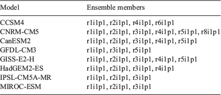
Estimates of the SST changes due to anthropogenic forcing were calculated using CMIP5 models by subtracting the ensemble-average decadal-average (1996–2005) SSTs of ‘natural’ simulations from the corresponding ‘all forcing’ simulations. An estimate was calculated for eight CMIP5 models (Table 1), and this estimated warming signal was then subtracted from the prescribed observed SSTs for 2015. Importantly, each model gives a different spatial distribution of estimated SST change since preindustrial conditions, including over the Indian and Pacific Oceans.
|
As an SST-forced model system, W@H has the advantage of having lower biases and reduced computational requirements than coupled models. However, SST-forced systems do not simulate coupled responses to forcing, and results are vulnerable to biases in the SST signal from other models.
The POAMA seasonal forecasting model has a quite low resolution (T47, ~250 km). It does not resolve land features of Tasmania and associated rainfall pattern (Fig. 1d), but does capture large-scale circulation variability (Hudson et al. 2013; Marshall et al. 2014), and the framework minimises drift (Wang et al. 2016). When used for attribution, POAMA compares a simulation with observed atmosphere, land and ocean initial conditions (‘Factual’) with simulations with CO2 concentrations set to 1960 levels (315 ppm) and the CO2 forced component of ocean temperature and salinity since 1960 removed from initial conditions (‘Counterfactual’), estimated from ensembles of 30-year simulations initialised from 1960 and 1970 compared to 2000 and 2010. Estimates of the CO2-forced component of land and atmospheric (moisture and temperature) responses are also removed. An ensemble of 33 simulations for Factual and 33 for Counterfactual conditions is examined. See additional material of Hope et al. (2015) and also Wang et al. (2016) for more details. An important difference between this method and the others is the ‘Counterfactual’ simulations approximate 1960 rather than preindustrial conditions, and only the change in CO2 forcing is considered (not ozone or aerosol).
We use W@H and POAMA for analysis of circulation anomalies, as these models have a simulation specific to the conditions of 2015 rather than the free-running CMIP5 models, and also because they will typically have lower biases. W@H is an SST-driven, atmosphere-only model, typically having lower biases than CMIP models (Massey et al. 2014; Black et al. 2016). Similarly, POAMA uses initialisations from observations, so it typically avoids large model biases (Wang et al. 2016).
2.2 Methods
The conditions of spring and summer 2015 are examined in observations, then in attribution modelling systems. We compare the Tasmanian October rainfall results from POAMA with the rainfall results from W@H-ANZ and CMIP5 already presented in Karoly et al. (2016). As POAMA has coarse resolution and does not resolve Tasmania, we calculate mean rainfall over a 5° × 5° latitude/longitude box of four cells over the region and examine the percent anomaly from the climatology as a form of bias correction. The histograms of the 36 simulations of rainfall Tasmanian anomaly in Factual and Counterfactual are fitted using the generalised extreme value (GEV) distribution. The significance of the differences between distributions was assessed using a Kolmogorov–Smirnoff (K–S) test at the 5% significance level, and then the FAR was calculated, where FAR = 1 − counterfactual/factual, and FAR risk as a proportion, FAR risk = (Factual/Counterfactual) × 100. As used in Karoly et al. (2016), we define an October rainfall threshold based on the previous observed record (56 mm in 1965) rather than the 2015 record, to reduce selection bias. The 1914 low rainfall value was not used because of the smaller number of rainfall stations available then (the rainfall gauge network has been relatively stable since the mid-1950s). We also examine the spatial distribution of the mean rainfall difference between Factual and Counterfactual in POAMA and compare this to W@H.
We examine the broader context of the dry October by extending the original work looking at precipitation alone to examine temperature, evaporation and a drought index. The increase in temperature attributable to human influence was estimated as the mean difference in Tasmanian temperature in Factual and Counterfactual simulations. The effect on potential evaporation is estimated as the difference in the climatological October Penman–Monteith (Allen et al. 1998) assuming Tasmanian climatological average wind speed, relative humidity and solar radiation remained unchanged. To examine the dryness in spring 2015, incorporating rainfall and evaporation anomalies, we examine the Keetch–Byram Drought Index (KBDI) of Keetch and Byram (1968) as a measure of dryness in each month September to November and spring as a whole. The KBDI uses antecedent rainfall and evaporation estimated from temperature.
Differences in circulation between Factual and Counterfactual simulations from W@H and POAMA were examined in two ways. First, the spatial distribution of the mean differences between Factual and Counterfactual in mean sea level pressure (MSLP) and zonal wind was compared. Second, a wide-ranging set of MSLP indices were calculated and compared, including the MSLP averaged over Tasmania, MSLP in boxes adapted from Hill et al. (2009) and the subtropical ridge (STR). Remote drivers of rainfall variability in Factual and Counterfactual simulations were explored using standard indices, namely atmospheric blocking in eastern Australia, the Southern Annular Mode (SAM), the Indian Ocean Dipole (IOD) and SST of the Indian Ocean. The differences between Factual and Counterfactual distributions of these indices were assessed using a K–S test and FAR analysis performed. Details of the averaging boxes and indices used are listed in Table 2.

|
3 Observed conditions
According to Australian Bureau of Meteorology records, rainfall averaged over all of Tasmania in spring 2015 rainfall was the lowest on record at 155 mm, 42% of the 1961–90 mean of 365 mm. Average October rainfall in Tasmania in 1961–90 is 124 mm, with much higher rainfall on the west coast than the midlands and east coast (Fig. 1a). October 2015 rainfall was also the lowest on record at 21 mm, 18% of the 1961–90 mean of 124 mm mean (Figs 1b, 2a).

|
Temperature was above average in September through February, including the hottest summer on record (mean summer temperature was +1.8°C above the 14.1°C average). October was warmer than average (+1.3°C), especially in daytime maximum temperature (+2.2°C warmer than the 14.3°C average). There was a detectable human influence on the hottest October on record for southern Australia (Black and Karoly 2016) and Australia as a whole (Hope et al. 2016), including the unusually warm conditions in Tasmania.
Turning to atmospheric circulation, variations in circulation and MSLP patterns results in a strong relationship between interannual variability in October MSLP in a box over Tasmania and October total rainfall with high local pressure associated with dry conditions (Table 2). In 1948–2015, MSLP from NCEP/NCAR Reanalysis 1 (Kalnay et al. 1996) has a correlation of R = −0.84 with rainfall in October (Fig. 2b). October 2015 MSLP was higher than average but not an October record over Tasmania; however, it was a record high north of Tasmania and record low north of the Ross Sea in NCEP/NCAR Reanalysis 1 since 1948 (Fig. 2c). This spatial distribution of the MSLP anomaly with and low pressure north of the Ross Sea is similar to the wave train structure of the Pacific South American (PSA) pattern and is typical of dry years in Tasmania reported in Hill et al. (2009). Wind anomalies at 850 hPa were predominately north-easterly, promoting warm air advection from the interior of mainland Australia and preventing cold moist air advection from the southern ocean over Tasmania, consistent with warmer and drier conditions in Tasmania. The MSLP pattern also produced a high STR index through October (+5.2 hPa, fifth highest on record since 1948).
Looking at remote drivers of variability, there was a strong El Niño in the Pacific through spring and summer 2015/16 (October NINO3.4 index was +2.2°C) and a strongly positive IOD event (Dipole Mode Index (DMI) was +0.76), both of which are typically associated with dry spring conditions. There were also record temperatures for any month to date in the southern Indian Ocean (an anomaly of 0.63°C in 30–120°E, 0–60 °S). There was a short-lived atmospheric blocking event in the Tasman Sea early in the month, the Bureau of Meteorology blocking index (Pook and Gibson 1999) at 140°E of the monthly mean conditions was negative. The Madden–Julian oscillation (MJO) was active in phase 2 later in October which is associated with heat extremes in southern Australia, particularly in summer (Marshall et al. 2014; Parker et al. 2014). The SAM was positive from around the 23rd October through to the end of the month, but the monthly mean SAM was weakly negative.
The possible effect of human influence on all of these circulation features and remote drivers of variability will be examined by comparing the Factual and Counterfactual simulations. Also, the issues regarding examining remote drivers in attribution studies are explored.
4 Results
4.1 October rainfall
Results from Karoly et al. (2016) showed a small but statistically significant difference in rainfall between Factual and Counterfactual treatments in both W@H and CMIP5, and the plots are not reproduced here. Here we complement those results with the analysis of rainfall in POAMA.
The distribution of the rainfall anomaly in POAMA for Tasmania has a lower median and a different shape in the Factual simulations compared to Counterfactual (Fig. 3a, averaging box marked in Fig. 3b). The median Tasmanian October rainfall in Factual is 8% (equivalent to −10 mm/month in observations) drier than the median in the Counterfactual simulations, which is similar to the results from W@H (7% or −8 mm/month) and CMIP5 (−6% or 7.5 mm/month) reported in Karoly et al. (2016). The GEV distribution of the Factual not only has a lower median but also is narrower and less skewed with a thinner high tail than the Counterfactual. This change in shape suggests that human influence has driven a reduction in the likelihood of wet months given the set-up in 2015.

|
The difference between the two POAMA distributions at the chosen threshold indicates the likelihood of low rainfall was increased (best estimate FAR risk is 48%), which is within the previous results from W@H-ANZ (at least 39%, median 75%) and CMIP5 (−12% to +82%, median of 25%) reported in Karoly et al. (2016). The 33 Counterfactual and 33 Factual samples are not significantly different (K–S test fails at 5% level). The small sample size is a contributing factor to the lack of significance. If 100 samples are randomly drawn from the GEV distributions fitted to the Factual and Counterfactual data, this creates synthetic data sets that are consistent with those distributions and have a sample size that is commensurate with the rainfall record (and still much smaller than the W@H results). These synthetic data sets are significantly different, where a K–S test passes at the 5% level, suggesting a small but significant role for human influence in the rainfall anomaly, supporting the results from W@H and CMIP5.
Since the difference in rainfall for Tasmania is small and the coarse resolution of POAMA model does not resolve the Tasmanian land mass, the results can only be considered indicative. Further insights into the rainfall signal and the circulation drivers behind it may be derived from the spatial distribution of the rainfall differences in Counterfactual simulations compared to Factual. The spatial pattern of rainfall difference between the mean of Factual and Counterfactual in POAMA shows reduced rainfall in a band across much of 35–45°S and in the Tasman Sea at ~25–30°S, with enhanced rainfall south of ~45°S (Fig. 3b). This pattern in W@H is similar (Fig. 3c), noting that the W@H mean is smoother and has lower values than POAMA as it is the mean of eight models; however, model agreement on the sign of the difference is high (stippling). This spatial pattern is consistent with a zonally consistent MSLP pressure anomaly around the hemisphere, similar to SAM, and is possibly also consistent with an influence from the teleconnection from the IOD that influences southern Australia.
4.2 Temperature and drought index
As well as rainfall, the other components of the dry October were warm temperatures and high evaporation. The results from CMIP5, W@H and POAMA indicate that October 2015 in Tasmania was warmer than a counterfactual world without human influence (Factual compared to Counterfactual). The mean difference in October Tasmanian mean temperature between Factual and Counterfactual in the eight W@H ensembles was 0.0–1.2°C (0.6°C eight-model mean). Tasmanian mean temperature in POAMA was 0.25°C warmer, and daily maximum temperature was 0.4°C warmer in Factual compared to 1960 conditions. Higher temperatures are associated with higher potential evaporation: 0.6°C warmer mean temperature suggests ~5% higher evapotranspiration (from a baseline of ~100 mm/month).
The KBDI drought index is a measure of overall dryness that integrates low rainfall as well as temperature and other variables, commonly used to gauge the contribution of dryness in the landscape to fire danger. In the W@H-ANZ simulations, there is a consistent shift in the distribution to drier values in Factual compared to Counterfactual in October and all spring months and spring as a whole (Fig. 3d). This indicates a higher probability of dry conditions in spring 2015 than for a world without human influence. For example, the median spring KBDI for Tasmania is 4.6 mm in Factual and 3.2 mm in Counterfactual simulations. In October, the median KBDI is 4.2 mm in Factual simulations and 3.0 mm in Counterfactual (75th percentiles are 7.4 and 5.5 mm). This is a more direct measure of the climate on preconditioning the landscape for the fires late in the summer than the rainfall or temperature in isolation and indicates that the human influence was ~30% greater in the Factual world compared to Counterfactual.
4.3 October mean sea level pressure indices and blocking
The results in the previous section suggest that October and spring 2015 in Tasmania were more likely to be dry than in a Counterfactual world without human influence due to lower rainfall, warmer temperatures and higher evaporation. The reduced rainfall has already been shown to be partly driven by the El Niño present. The rainfall difference between Counterfactual and Factual is also consistent with a shift in MSLP and circulation similar to SAM, so next we examine a set of circulation patterns and indices.
The October MSLP anomaly from reanalysis (Fig. 2c), including maxima over Australia and the southeast Pacific and minima north of the Ross Sea, was approximately replicated in the mean of W@H (Fig. 4a) and POAMA (Fig. 4b). However, the difference in MSLP between Factual and Counterfactual in both W@H (Fig. 4c) and POAMA (Fig. 4d) shows that the forced MSLP signal was not an enhancement of the anomaly pattern but has a different spatial structure. This suggests that the specific circulation set-up of the event was not enhanced due to human influence, but some elements of the background circulation state were affected by anthropogenic forcing, and this explains the effect on rainfall. To determine the nature of the human forcing on this background circulation, the spatial pattern of the MSLP signal and a range of indices of various circulation features are analysed.

|
First, we can readily exclude the possibilities of local MSLP, STR, the PSA and blocking. MSLP over Tasmania itself is strongly correlated with rainfall (Fig. 2b); however, an increase in MSLP over Tasmania does not appear to be a component of the human signal on rainfall in this case. There is little difference between Counterfactual and Factual for MSLP within the Tasmanian box in either modelling set-up (Figs 3c and d), with a K–S test failing to detect significance at 5% for 6 of the 8 W@H cases and for POAMA. Similarly, the STR intensity and position is largely similar between Counterfactual and Factual (K–S test fails to detect significant differences in all cases). The forced component of the MSLP response does not appear like a PSA-like pattern, and the MSLP difference between the boxes adapted from Hill et al. (2009) is not enhanced significantly between Factual and Counterfactual (K–S test fails in most cases). Blocking was present early in the month, but the mean Blocking Index at 140°E was negative in the October mean. As expected from the MSLP results, zonal wind at 500 hPa is enhanced south of Tasmania and reduced to the north in Factual compared to Counterfactual in W@H and POAMA (Figs 4e and f). This pattern is not consistent with an enhanced mean blocked state in the Australian sector, with October mean blocking index at 140°E very similar in Counterfactual and Factual in all model groups.
Second, we examine the circulation feature suggested by the rainfall results: SAM. The forced midlatitude MSLP response appears consistent with a shift in the mean state of the circulation that appears similar to SAM (Fig. 4), and indeed the SAM index is significantly enhanced in Factual compared to Counterfactual simulations in both W@H and POAMA (all K–S tests pass). The mean SAM index was higher in Factual compared to Counterfactual by 0.2–0.3 in W@H and 0.3 in POAMA. Therefore, direct examination of the MSLP differences between Factual and Counterfactual support the rainfall results. Namely, that human influence on the mean circulation and background state of MSLP that appears similar to SAM has changed the probability distribution rainfall in the 35–45°S band, including a greater chance of drier conditions, including in Tasmania in October 2015, even though the specific set-up during that month was not enhanced by human influence.
4.4 October Indian Ocean temperature and Indian Ocean Dipole
In spring 2015 there was a strong El Niño present in the Pacific that played a role in the dry October (Karoly et al. 2016), and there was also a strong positive IOD event present, and the Indian Ocean as a whole was particularly warm. Along with the influence from mean circulation described above, there may have been an effect of human influence on the El Niño and positive IOD events present that then had an influence on Tasmania’s rainfall. Mean warming of SST due to human influence is not spatially uniform. The specific SST warming pattern is an important source of uncertainty in regional rainfall projections of future climate (Watterson 2012; Grose et al. 2014), and so it fits that it is a source of uncertainty in the attribution of climate change to date. Here we examine the effect of changes to the mean state on the possible influence from the Indian Ocean as another line of supporting evidence behind attributing the dry event.
In the Indian Ocean, a different warming in the eastern Indian Ocean compared to the west would affect the mean state of the DMI and change the probabilities of IOD positive and negative events. Any persistent shift in the IOD is expected to have flow-on effects to atmospheric circulation and rainfall. The W@H modelling takes the SST signal from eight CMIP5 models, and the mean of these models shows a fairly uniform warming on the Indian Ocean and an enhanced warming of the equatorial Pacific (Fig. 5a). This mean SST warming suggests no strong change in the IOD, but a change to a more El Niño-like mean state in the Pacific. Each CMIP5 model gives a different estimate of the mean warming in the Indian Ocean and Pacific to date (Appendix 1), and this gives each set of W@H simulations a different estimate of the mean shift in the DMI, including some with a more positive and some more negative DMI (Fig. 5c).

|
POAMA generates its own SST difference between 1961 and the present, and the October difference shows a north-south gradient in Indian Ocean warming and a slight enhancement of warming in the equatorial Pacific (Fig. 5b). The POAMA Factual simulations have a slightly higher DMI than the Counterfactual simulations (mean difference 0.03, Fig. 5d).
Without a reliable estimate of the forced warming signal in the Indian and Pacific Oceans, it is not possible to determine the true effect of human influence on the El Niño–Southern Oscillation (ENSO) and IOD to date and examine the effect on individual extremes of circulation and rainfall. The results are more consistent regarding the mean temperature of the Indian Ocean, which is notably higher in the Factual simulations than in Counterfactual for both W@H and POAMA (Figs 5e, 4f).
5 Discussion and conclusions
The aim of this paper is to supplement the initial probabilistic event attribution results on Tasmanian rainfall in October 2015 from Karoly et al. (2016) with further supporting evidence and a wider context. Three lines of new evidence were presented: rainfall results from another modelling system; an examination of temperature, evaporation and drought index; and analysis of the circulation drivers behind the rainfall anomaly.
The outputs of three modelling systems were used, and they differ in how they simulate the current climate and how they condition the counterfactual climate. POAMA uses a coupled seasonal forecast model to simulate the Factual climate from a given initialisation and generate a Counterfactual climate by removing the ocean warming and atmospheric CO2 concentration changes from that initial state. W@H uses an atmosphere-only model using the observed ocean state to generate many simulations of the atmosphere given the observed ocean conditions, then generates a Counterfactual climate by removing an estimated ocean warming pattern as well as atmospheric conditions from CMIP5 climate models. CMIP5 models were also used directly, which are free-running simulations of the global climate system not initialised to the observed conditions, run with either observed forcings or natural forcings only. Any agreement between all three modelling systems indicates a consistent simulation of a human signal in the underlying climate and is less likely to be affected by the model bias of any one system.
The three systems do broadly agree on a statistically significant difference between Factual and Counterfactual simulations of Tasmanian rainfall in October 2015, but with a fairly small mean difference, as would be expected due to the lower signal-to-noise ratio of rainfall compared to variables such as temperature. Rainfall was on average 8% lower in POAMA Factual simulations compared to Counterfactual, similar to 7% in W@H and 6% in CMIP5. Considering that POAMA is an initialised forecast model, W@H is an atmospheric model using the ocean state of 2015 and CMIP5 are free-running climate models; this similarity of results suggests a fairly consistent human signal in reduced rainfall and is reflected in a mean-state difference (CMIP5) as well as in the ocean conditions specifically of that year (POAMA, W@H). These results also suggest there was a greater chance of record-breaking dry conditions due to human influence on the climate, since a drier mean climate for the given ocean and atmospheric state. Specifically on the rainfall record in Tasmania in October, the results suggest the probability was increased due to human influence, with a median estimate of the increase in attributable risk for the previous record threshold (56 mm, experienced in 1965) of ~48% in POAMA, which is of similar order as W@H (75%) and CMIP5 (25%). Detecting and attributing a human signal in rainfall is less clear than for variables such as temperature, and consistent results from three model systems that are relatively independent and quite distinct in their overall approach provide stronger evidence than the results from one model alone.
Another contributor to the extreme dry conditions in spring 2015 in Tasmania was high temperature and evaporation. The combination of rainfall and evaporation is summarised by the KBDI drought index. The results suggest that human influence contributed to both the warmer temperature (by ~0.4–0.6°C), and higher evaporation rate (~10 mm/month or 10%) in October. Results from one modelling method indicate that dryness measured using KBDI was enhanced in each month of spring by values of ~30%. Despite the simple methods used here, the effect of human influence on temperature is well established so there is high confidence in this attribution finding than in rainfall. The drought index is perhaps the most relevant metric to the drying of the landscape that preceded the fires, so this result is particularly relevant there.
The POAMA and W@H models both suggested that human influence did not drive an enhancement of the particular atmospheric set-up of the dry month, as expressed in MSLP over Tasmania, STR, PSA or blocking. The results do suggest that human influence led to enhanced MSLP around the southern hemisphere in October 2015 in a pattern reminiscent of the SAM, and this contributes to a shift in probabilities of rainfall, including the rainfall linked to the particular monthly set-up in October 2015. Human signals on circulation changes are not always clear or detectable (Vallis et al. 2015), but these results are suggestive and consistent with a previously identified forced response, namely that MSLP has been increasing in this latitude band in recent decades and this is partly attributable to human influence (e.g. Gillett et al. 2013). While a higher SAM index is associated with lower rainfall across Tasmania in spring (Risbey et al. 2009), the SAM index was not particularly high in October 2015, so the difference between Factual and Counterfactual is a relative enhancement of the SAM-like state of the atmosphere, not an extreme SAM event. An increased likelihood of a SAM-like MSLP anomaly driving lower rainfall for a particular month is a logical extension of this known change in the mean state. Also, the result is consistent with the evidence that high MSLP south of Australia in August 2014 was more likely due to human influence (Grose et al. 2015). MSLP and SAM changes have been found to be driven by changes to not only greenhouse gases but also stratospheric ozone changes. POAMA does not include the forcing from ozone depletion, and its interaction with greenhouse gas forcing in summer (Morgenstern et al. 2014), and this may affect the results from this model.
The results do not suggest that anthropogenic forcings notably affected mean monthly MSLP over Tasmania itself, mean monthly atmospheric blocking at 140°E, the STR, or the PSA-like MSLP pattern. There has not been a published attribution of a change to these drivers due to human influence previously, so these new results support previous work.
Along with SAM, the results suggest that human influence drove a warmer Indian Ocean, and this may have affected rainfall over southern Australia and may have also influenced the IOD. However, the analysis has revealed a particular concern with the framework for examining this question. Gauging the role of the IOD and other SST-based indices relies entirely on the estimate of mean SST warming and so varies between models and methods. The W@H framework uses SST signals generated by Global Climate Models (GCMs), and these vary widely, while the POAMA framework generates its own distinct SST change signal. The range of these estimates and their possible effects suggests that we need a reliable estimate of mean SST warming to date to properly account for the human influence on phenomena such as IOD, and also the ENSO in the Pacific.
Attribution of rainfall change or extreme rainfall events remains difficult and less clear than for temperature for several reasons. Rainfall events have a low signal-to-noise ratio, meaning any potential signal can be harder to distinguish. Models contain errors and biases in the simulation of the relevant processes, where both dynamic and thermodynamic processes are involved and it is essential to consider both (e.g. Otto et al. 2016). Tasmanian rainfall is strongly determined by the interaction of weather systems with topography, and models typically do not finely resolve the topography of Tasmania.
Given these uncertainties, one useful line of evidence for attributing a rainfall event is the reliable attribution of a large-scale circulation driver that partly or largely influenced the rainfall anomaly, to establish a physical basis or narrative behind the attribution. Here, the results suggest that a SAM-like pressure pattern was enhanced due to human influence, and a change in the mean state of this SAM-like pattern has previously been attributed to human influence. This adds some confidence that at least the circulation component of the rainfall event has some physical basis. But the analysis of circulation and drivers presented here is not comprehensive, and in fact the results illustrate some barriers to fully quantifying the effect of climate change to date on regional rainfall extremes. Thermodynamic drivers, including the direct effects of warmer temperatures, are likely to be more reliably accounted for in the models than circulation.
Overall, three lines of additional evidence presented here strengthen the attribution statement for the record low rainfall conditions in Tasmania in spring 2015 of a small but significant contribution from human influence, but confidence in this attribution is still weaker than for events such as heatwaves or other heat extremes.
Acknowledgements
This research was supported by the Australian Government’s National Environmental Science Programme Earth System and Climate Change hub (NESP ESCC). We would like to thank Weather@Home ANZ, which involves collaboration with Oxford University, the Met Office, NIWA in New Zealand, and the Tasmanian Partnership for Advanced Computing. We thank the POAMA seasonal forecasting group for providing access to POAMA model outputs. We acknowledge the WCRP Working Group on Coupled Modelling, which is responsible for CMIP5 and thank the climate modelling groups for making available their model output. NCEP/NCAR Reanalysis 1 data were provided by the NOAA/CIRES Climate Diagnostics Center in Boulder (USA). This research did not receive any specific funding.
References
Allen, M. R. (2003). Liability for climate change. Nature 421, 891–892.| Liability for climate change.Crossref | GoogleScholarGoogle Scholar |
Allen, R. G., Pereira, L. S., Raes, D., and Smith, M. (1998). Crop evapotranspiration – guidelines for computing crop water requirements. In: ‘FAO Irrigation and Drainage Paper 56’. (Food and Agriculture Organization of the United Nations: Rome, Italy.)
Black, M. T., and Karoly, D. J. (2016). Southern Australia’s warmest October on record: the role of ENSO and climate change. Bull. Am.Meteorol. Soc. 97, S20.
| Southern Australia’s warmest October on record: the role of ENSO and climate change.Crossref | GoogleScholarGoogle Scholar |
Black, M. T., Karoly, D. J., Rosier, S. M., Dean, S. M., King, A. D., Massey, N. R., Sparrow, S. N., Bowery, A., Wallom, D., Jones, R. G., Otto, F. E. L., and Allen, M. R. (2016). The weather@home regional climate modelling project for Australia and New Zealand. Geosci. Model Dev. 9, 3161–3176.
| The weather@home regional climate modelling project for Australia and New Zealand.Crossref | GoogleScholarGoogle Scholar |
Bureau of Meteorology, A. (2015). ‘Monthly Weather Review, Australia October 2015’. (Melbourne, Australia.)
Donlon, C. J., Martin, M., Stark, M., Roberts-Jones, J., Fiedler, E., and Wimmer, W. (2012). The operational sea surface temperature and sea ice analysis (OSTIA) system. Remote Sens. Environ. 116, 140–158.
| The operational sea surface temperature and sea ice analysis (OSTIA) system.Crossref | GoogleScholarGoogle Scholar |
Drosdowsky, W. (2005). The latitude of the subtropical ridge over eastern Australia: the L index revisited. Inter. J. Climatol. 25, 1291–1299.
| The latitude of the subtropical ridge over eastern Australia: the L index revisited.Crossref | GoogleScholarGoogle Scholar |
Gillett, N. P., Fyfe, J. C., and Parker, D. E. (2013). Attribution of observed sea level pressure trends to greenhouse gas, aerosol, and ozone changes. Geophys. Res. Lett. 40, 2302–2306.
| Attribution of observed sea level pressure trends to greenhouse gas, aerosol, and ozone changes.Crossref | GoogleScholarGoogle Scholar |
Grose, M. R., Bhend, J., Narsey, S., Gupta, A. S., and Brown, J. R. (2014). Can we constrain CMIP5 rainfall projections in the tropical Pacific based on surface warming patterns? J. Clim. 27, 9123–9138.
| Can we constrain CMIP5 rainfall projections in the tropical Pacific based on surface warming patterns?Crossref | GoogleScholarGoogle Scholar |
Grose, M. R., Black, M. T., Risbey, J. S., Uhe, P., Hope, P. K., Haustein, K., and Mitchell, D. (2018). Severe frosts in Western Australia in September 2016. Bull. Am. Meteorol. Soc. 99, S150–S154.
| Severe frosts in Western Australia in September 2016.Crossref | GoogleScholarGoogle Scholar |
Grose, M. R., Risbey, J. S., Black, M. T., and Karoly, D. J. (2015). Attribution of exceptional mean sea level pressure anomalies south of Australia in August 2014. Bull. Am. Meteorol. Soc. 96, S158–S162.
| Attribution of exceptional mean sea level pressure anomalies south of Australia in August 2014.Crossref | GoogleScholarGoogle Scholar |
Hill, K. J., Santoso, A., and England, M. H. (2009). Interannual Tasmanian rainfall variability associated with large-scale climate modes. J. Clim. 22, 4383–4397.
| Interannual Tasmanian rainfall variability associated with large-scale climate modes.Crossref | GoogleScholarGoogle Scholar |
Hope, P., Lim, E.-P., Wang, G., Hendon, H. H., and Arblaster, J. M. (2015). Contributors to the record high temperatures across Australia in late spring 2014. Bull. Am. Meteorol. Soc. 96, S149–S153.
| Contributors to the record high temperatures across Australia in late spring 2014.Crossref | GoogleScholarGoogle Scholar |
Hope, P. K., Wang, G., Lim, E.-P., Hendon, H. H., and Arblaster, J. M. (2016). What caused the record-breaking heat across Australia in October 2015? Bull. Am. Meteorol. Soc. 97, S20.
| What caused the record-breaking heat across Australia in October 2015?Crossref | GoogleScholarGoogle Scholar |
Hudson, D., Marshall, A. G., Yin, Y., Alves, O., and Hendon, H. H. (2013). Improving intraseasonal prediction with a new ensemble generation strategy. Mon. Wea. Rev. 141, 4429–4449.
| Improving intraseasonal prediction with a new ensemble generation strategy.Crossref | GoogleScholarGoogle Scholar |
Jones, D. A., Wang, W., and Fawcett, R. (2009). High-quality spatial climate data-sets for Australia. Aust. Meteorol. Ocean. 58, 233–248.
| High-quality spatial climate data-sets for Australia.Crossref | GoogleScholarGoogle Scholar |
Kalnay, E., Kanamitsu, M., Kistler, R., Collins, W., Deaven, D., Gandin, L., Iredell, M., Saha, S., White, G., Woollen, J., Zhu, Y., Leetmaa, A., Reynolds, R., Chelliah, M., Ebisuzaki, W., Higgins, W., Janowiak, J., Mo, K. C., Ropelewski, C., Wang, J., Jenne, R., and Joseph, D. (1996). The NCEP/NCAR 40-year reanalysis project. Am. Meteorol. Soc. 77, 437–471.
Karoly, D. J., Black, M., Grose, M. R., and King, A. D. (2016). The roles of climate change and El Niño in the record low rainfall in October 2015 in Tasmania, Australia. Bull. Am. Meteorol. Soc. 97, S18.
| The roles of climate change and El Niño in the record low rainfall in October 2015 in Tasmania, Australia.Crossref | GoogleScholarGoogle Scholar |
Keetch, J. J., and Byram, G. M. (1968). A drought index for forest fire control. In: ‘Research Paper’, SE-38: 35 p. (Department of Agriculture, Forest Service, Southeastern Forest Experiment Station: Asheville, NC, USA.)
Marshall, A. G., Hudson, D., Wheeler, M. C., Alves, O., Hendon, H. H., Pook, M. J., and Risbey, J. S. (2014). Intra-seasonal drivers of extreme heat over Australia in observations and POAMA-2. Clim. Dyn. 43, 1915–1937.
| Intra-seasonal drivers of extreme heat over Australia in observations and POAMA-2.Crossref | GoogleScholarGoogle Scholar |
Marshall, G. J. (2003). Trends in the Southern Annular Mode from observations and reanalyses. J. Clim. 16, 4134–4143.
| Trends in the Southern Annular Mode from observations and reanalyses.Crossref | GoogleScholarGoogle Scholar |
Massey, N., Jones, R. G., Otto, F. E. L., Aina, T., Wilson, S., Murphy, J. M., Hassell, D., Yamazaki, Y. H., and Allen, M. R. (2014). weather@home—development and validation of a very large ensemble modelling system for probabilistic event attribution. Q. J. R. Meteorol. Soc. 141, 1528–1545.
| weather@home—development and validation of a very large ensemble modelling system for probabilistic event attribution.Crossref | GoogleScholarGoogle Scholar |
Min, S. K., Zhang, X. B., Zwiers, F. W., and Hegerl, G. C. (2011). Human contribution to more-intense precipitation extremes. Nature 470, 378–381.
| Human contribution to more-intense precipitation extremes.Crossref | GoogleScholarGoogle Scholar |
Morgenstern, O., Zeng, G., Dean, S. M., Joshi, M., Abraham, N. L., and Osprey, A. (2014). Direct and ozone-mediated forcing of the Southern Annular Mode by greenhouse gases. Geophys. Res. Lett. 41, 9050–9057.
| Direct and ozone-mediated forcing of the Southern Annular Mode by greenhouse gases.Crossref | GoogleScholarGoogle Scholar |
National Academies of Sciences, Engineering, and Medicine (2016). ‘Attribution of Extreme Weather Events in the Context of Climate Change’. (The National Academies: Washington, DC, USA.)
Otto, F. E. L. (2016). Extreme events: the art of attribution. Nat. Clim. Change 6, 342–343.
| Extreme events: the art of attribution.Crossref | GoogleScholarGoogle Scholar |
Otto, F. E. L., van Oldenborgh, G. J., Eden, J., Stott, P. A., Karoly, D. J., and Allen, M. R. (2016). The attribution question. Nat. Clim. Change 6, 813–816.
| The attribution question.Crossref | GoogleScholarGoogle Scholar |
Parker, T. J., Berry, G. J., Reeder, M. J., and Nicholls, N. (2014). Modes of climate variability and heat waves in Victoria, southeastern Australia. Geophys. Res. Lett. 41, 6926–6934.
| Modes of climate variability and heat waves in Victoria, southeastern Australia.Crossref | GoogleScholarGoogle Scholar |
Pook, M. J., and Gibson, T. T. (1999). Atmospheric blocking and storm tracks during SOP-1 of the FROST Project. Aust. Meteorol. Mag. 48, 51–60.
Risbey, J., and O’Kane, T. (2011). Sources of knowledge and ignorance in climate research. Clim. Change 108, 755–773.
| Sources of knowledge and ignorance in climate research.Crossref | GoogleScholarGoogle Scholar |
Risbey, J. S., Pook, M. J., McIntosh, P. C., Wheeler, M. C., and Hendon, H. H. (2009). On the remote drivers of rainfall variability in Australia. Mon. Wea. Rev. 137, 3233–3253.
| On the remote drivers of rainfall variability in Australia.Crossref | GoogleScholarGoogle Scholar |
Saji, N. H., Goswami, B. N., Vinayachandran, P. N., and Yamagata, T. (1999). A dipole mode in the tropical Indian Ocean. Nature 401, 360–363.
| A dipole mode in the tropical Indian Ocean.Crossref | GoogleScholarGoogle Scholar |
Stott, P. A., Christidis, N., Otto, F. E. L., Sun, Y., Vanderlinden, J.-P., van Oldenborgh, G. J., Vautard, R., von Storch, H., Walton, P., Yiou, P., and Zwiers, F. W. (2016). Attribution of extreme weather and climate-related events. WIREs Clim. Change 7, 23–41.
| Attribution of extreme weather and climate-related events.Crossref | GoogleScholarGoogle Scholar |
Stott, P. A., Stone, D. A., and Allen, M. R. (2004). Human contribution to the European heatwave of 2003. Nature 432, 610–614.
| Human contribution to the European heatwave of 2003.Crossref | GoogleScholarGoogle Scholar |
Taylor, K. E., Stouffer, R. J., and Meehl, G. A. (2012). An overview of CMIP5 and the experiment design. Bull. Am. Meteorol. Soc. 93, 485–498.
| An overview of CMIP5 and the experiment design.Crossref | GoogleScholarGoogle Scholar |
Trenberth, K. E., Fasullo, J. T., and Shepherd, T. G. (2015). Attribution of climate extreme events. Nat. Clim. Change 5, 725–730.
| Attribution of climate extreme events.Crossref | GoogleScholarGoogle Scholar |
Vallis, G. K., Zurita-Gotor, P., Cairns, C., and Kidston, J. (2015). Response of the large-scale structure of the atmosphere to global warming. Q. J. R. Meteorol. Soc. 141, 1479–1501.
| Response of the large-scale structure of the atmosphere to global warming.Crossref | GoogleScholarGoogle Scholar |
Wang, G., Hope, P. K., Lim, E.-P., Hendon, H. H., and Arblaster, J. M. (2016). Three methods for the attribution of extreme weather and climate events. In: Bureau of Meteorology Research Report. 018: 32 pp. Available at http://www.bom.gov.au/research/research-reports.shtml [Verified 20 April 2020].
Watterson, I. (2012). Understanding and partitioning future climates for Australian regions from CMIP3 using ocean warming indices. Clim. Change 111, 903–922.
Appendix 1.
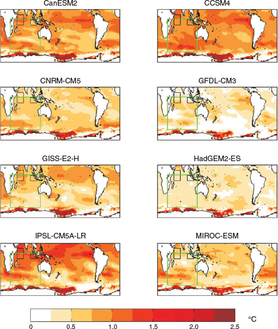
Mean Factual–Counterfactual surface temperature difference in each of the W@H model ensembles (directly inherited from GCM, names indicated in title), showing different estimates of mean warming and also spatial distribution of warming from each model.
|