
Seasonal climate summary for the southern hemisphere (summer 2019–20): a summer of extremes
Naomi Benger A * and Bernard Chapman B *
A Bureau of Meteorology, Science and Innovation Group, Level 4, 431 King William Street, Adelaide, SA 5000, Australia.
B Bureau of Meteorology, Business Solutions Group, GPO Box 413, Brisbane, Qld 4001, Australia.
Handling Editor: Blair Trewin
Abstract
This is a summary of the southern hemisphere atmospheric circulation patterns and meteorological indices for summer 2019–20; an account of seasonal rainfall and temperature for the Australian region is also provided. The antecedent climate conditions and climatic drivers for summer 2019–20 resulted in unprecedented extremes for Australia, with many heat and fire weather extremes. The austral summer of 2019–20 was staged to be hot and dry, with climate drivers supporting higher than average temperatures and lower than average rainfall. These conditions contributed to the highest recorded monthly accumulated national Forest Fire Danger Index. As the dominant climate influence for December receded during the season, dynamic (weather) processes dominated for changeable conditions – particularly in the mid-latitudes. Both January and February were among the 10 hottest on record, although several mid-latitude sites experienced unusually cool days. Across the rest of the hemisphere, conditions were also extreme, with notable drought conditions persisting from spring over large parts of South America. Temperature anomalies for land and ocean areas of the southern hemisphere were respectively the third and second highest on record.
Keywords: 2019, 2020, Black summer of fire, climate summary, Forest Fire Danger Index, Indian Ocean Dipole, Pacific, seasonal summary, severe Tropical Cyclone Damien, southern hemisphere, summer, summer of extremes.
1.Introduction
The austral summer of 2019–20 began hot and dry. The strongly positive Indian Ocean Dipole (IOD) lingered into the summer as the southward progression of the monsoon trough was unusually late. Notably, this dominating climate driver supports higher than average temperatures and lower than average rainfall for much of Australia. The nationally driest spring on record (Bureau of Meteorology 2019a) and continuing hot and dry conditions in early summer led to extreme fire conditions in December, Australia’s warmest and driest December on record (nationally) with December 2019 recording the highest monthly accumulated national Forest Fire Danger Index (FFDI) since 1950 (Bureau of Meteorology 2019b).
As the Australian–Indonesian monsoon trough finally migrated south toward the end of December, rainfall onset commenced in the Australian tropical regions, ~3 weeks later than usual. With the influence of the positive IOD now diminished, stochastic weather processes began to dominate in the mid-latitudes leading to highly changeable conditions across much of Australia. By contrast, during January and February, warm conditions prevailed in the tropics. Tropical cyclones (TCs) and stochastic weather processes in the mid-latitudes brought many sites record rainfall, resulting in wetter than average January and February nationally. Temperatures fluctuated with the stochastic weather systems, although both January and February were among the 10 warmest on record, some mid-latitude sites also experienced record cold days. Conditions across the remainder of the southern hemisphere during the austral summer of 2019–20 were like those experienced in Australia with the key impacts being warmer and drier than average conditions, especially in South America.
This summary reviews the southern hemisphere and near equatorial climate patterns relevant to austral summer 2019–20, and some of the associated impacts, with particular attention to the Australasian and equatorial regions of the Pacific and Indian Ocean basins. The main sources of information for this report are analyses prepared by the Australian Bureau of Meteorology, the United States National Oceanic and Atmospheric Administration (NOAA) and the Global Precipitation Climatology Centre (GPCC). This summary shows a very distinct delineation within the summer for the Australian region, an initial period dominated by strong climate drivers followed by a highly dynamic period driven by synoptic processes.
2.Data sources
In addition to the information sourced from NOAA and GPCC, the Australian Bureau of Meteorology operates a suite of numerical weather prediction (NWP) models, named the Australian Community Climate and Earth System Simulator (ACCESS).1 Objective analyses used in this study are mostly obtained from ACCESS-G at 0.5° resolution. Charts sourced for Section 7 originate from ACCESS-G.
Real-time rainfall analyses (Section 10) of accumulated precipitation are obtained from the Bureau of Meteorology at http://www.bom.gov.au/jsp/awap/rain/index.jsp. The analysis system is described in Jones et al. (2009, pp. 233–248). Temperature anomalies in Section 8.1 are calculated with respect to the period 1961–90, and percentile-based analyses for the period from the start of the relevant dataset to 2017. ACORN-SAT version 2, released in December 2018 was used in the preparation of this document.2
The anomaly maps in Section 9 are a product of a merged land surface temperature (Global Historical Climatology Network, GHCN) and sea surface temperature (SST; ERSST version 5) anomaly analysis. Temperature anomalies for land and ocean are analysed separately and then merged to form the global analysis.3
The ‘CAMS_OPI’ data are 2.5° latitude and longitude spatial means of monthly mean precipitation derived from station gauges and satellite estimates. Anomalies have been recomputed using the 1979–2000 base period.
3.Pacific and Indian Ocean basin climate indices
The Indian and Pacific Oceans play a significant role in Australia’s climate variability. Variations in SSTs in the tropical regions in both oceans have been shown to increase the potential for rainfall and temperature extremes for Australia.
During the summer of 2019–20, all three of the Southern Oscillation Index4 (SOI), El Niño–Southern Oscillation (ENSO) NINO3.4 and 5VAR5 indices remained neutral. These are the primary indices used to measure variations in SSTs and atmospheric conditions along the tropical Pacific Ocean, with such variations well known to influence the climate in the Australian region. When indices are neutral, other climate drivers tend to dominate – this was the case for the summer of 2019–20. The IOD is the difference in ocean temperatures from the western node of the tropical Indian Ocean (centred on the equator, off the coast of Somalia) and the eastern node (off the coast of Sumatra).6 The IOD is said to be in a positive phase when values of the Dipole Mode Index (DMI) are greater than 0.4°C, negative when DMI values are less than −0.4°C and neutral otherwise. The positive and negative phases of the IOD are known to significantly influence Australian rainfall. The IOD is not usually a major driver of the Australian climate during the average austral summer. This is due to the monsoon trough shifting south over the tropical Indian Ocean and changing the overall wind circulation meaning that an IOD ocean temperature pattern cannot be sustained. The influence of the positive IOD event of 2019, however, continued into summer as the monsoon trough remained farther north than usual, supporting a late weakening of the IOD. The monsoon trough had its latest departure from India in history, only beginning its retreat on 9 October, compared to the usual 1 September (ET Bureau 2019). The 2019 strong positive IOD event peaked at +2.06 in late October 2019 and the IOD remained positive until late December when it returned to neutral (Fig. 1).
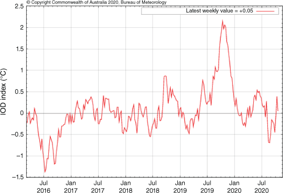
During positive IOD periods we typically observe above average maximum temperatures in the west and south of Australia, and above average minimum temperatures in the south-west, but below average minimum temperature in the tropics. Although the 2019 positive IOD was a contributing factor, the above average maximum temperatures and much below average rainfall for December 2019 were so widespread that the long-term rainfall deficiencies also played a significant role by reinforcing this aridity, along with the positive Southern Annular Mode (SAM) (Section 7.1), see more detail in Section 8.1.
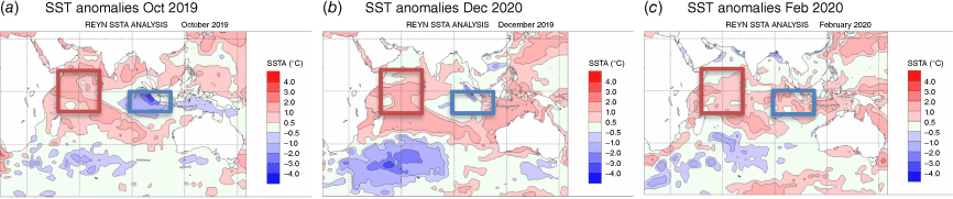
The positive IOD was driven by negative SST anomalies near Java and positive SST anomalies near the Horn of Africa as highlighted by the blue and red boxes respectively in Fig. 2. The peak of the positive IOD was in October 2019 (Fig. 2a). The negative anomaly in the east retracted significantly in December 2019 (Fig. 2b) and became a positive anomaly in February 2020, and the positive anomaly in the west lessened but remained positive (Fig. 2c). Also of note was the significant increase in SST anomalies around Australia in summer (Fig. 2) – this will be referred to again in Section 8.
4.Outgoing longwave radiation (OLR)
The OLR in the equatorial Pacific Ocean can be used as an indicator of enhanced or suppressed tropical convection. Increased positive OLR anomalies typify a regime of reduced convective activity, a reduction in cloudiness and, usually, rainfall. Conversely, negative OLR anomalies indicate enhanced convection, increased cloudiness and chances of increased rainfall. When Australia is under the influence of a positive IOD event, OLR anomalies are positive over southern Australia with broader impacts causing droughts over Indonesia and south-eastern Australia and flooding in the eastern part of Africa (Saji et al. 1999).
There were two distinct bursts of eastward-moving convection during the summer, as approximated by the black ellipses on the Hovmöller diagram of daily averaged OLR anomalies near and along the equator (15°S–15°N) during spring 2019 and summer 2019–20 (Fig. 3). Eastward movement of a strong Madden–Julian Oscillation (MJO) event would be seen as a diagonal line of blue (downward from left to right) in the OLR diagram. These diagonal lines would most likely fall between 60°E and 150°E and they would be repeated nearly every 1–2 months.
Time–longitude plot of daily averaged outgoing long-wave radiation (OLR) anomalies at the equator over the period September 2019 to March 2020. OLR anomaly is from daily data with respect to a base period of 1979–2010, using interpolated OLR data provided by the NOAA/OAR/ESRL PSD, Boulder, CO, USA.
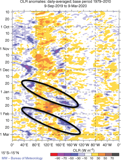
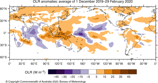
Fig. 3 and 4 also show strongly positive OLR anomalies present across the Maritime Continent and northern Australia, which corresponded with reduced rainfall in these regions. Positive OLR anomalies were analysed over much of the land area in the southern hemisphere, including much of the eastern half of Australia and particularly across the Maritime Continent (Fig. 4). Refer to Section 9 for a description of some impacts of the positive IOD event.
5.MJO, tropical cyclone activity and impacts
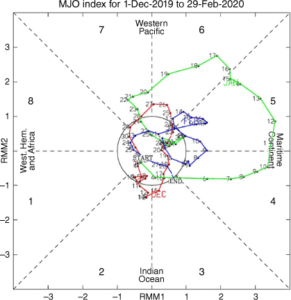
The phase-space diagram of the Real-time Multivariate (RMM) for summer 2019–20 is shown in Fig. 5. The MJO is a tropical convective wave anomaly, which develops in the Indian Ocean and propagates eastwards into the Pacific Ocean (Madden and Julian 1971, 1972, 1994).7 The MJO takes ~30–60 days to reach the western Pacific, with a frequency of 6–12 events per year (Donald et al. 2004). The MJO is associated with areas of increased or decreased tropical convection over the Australian region during summer, depending on its location. A description of the RMM MJO index and the associated phases is documented in Wheeler and Hendon (2004).
In the first week of December, the MJO was in a weak and indiscernible phase, positioned over the western Indian Ocean. Aided by the passage of a Kelvin wave and a favourable window in the MJO, TC ‘Belna’ formed to the west of the Seychelles with the system eventually making landfall along Madagascar’s northern coast. The re-emergence of a weak MJO signal during the last week of December spawned a short-lived TC ‘Sarai’ near Fiji. Refer to Section 9 for information regarding the impacts from these systems.
The MJO remained weak into the first week of January. Notwithstanding this, TC ‘Blake’ formed off the north coast of Western Australia on 6 January. Flooding due to the associated heavy rainfall was the main impact for the West Kimberley and parts of the Interior districts of Western Australia. Re-emergence of the oscillation into phase 4 (Maritime Continent) on 7 January was the commencement of a period of an active MJO into mid-January at least. This contributed to the development of TC ‘Claudia’ (12 January). The precursor low of ‘Claudia’ produced intense rainfall and localised flash flooding west of Darwin on 11 January where Dum In Mirrie Airstrip recorded a 24-h rainfall of 562 mm (a record for the Northern Territory). The strong pulse of the MJO tracked well east of the Australian region by 21 January leaving a widespread suppressing influence in relation to cloud and rainfall over northern Australia in its wake.
Despite a period of weak MJO signal through the first week of February, TC ‘Damien’ formed on 6 February off the north-west Australian coast. On 8 February, ‘Damien’ made landfall along the Pilbara Coast in north-west Western Australia. It was the strongest TC to cross the Western Australian coast since TC ‘Christine’ in 2013. Sustained gales were observed along parts of the Pilbara coast and islands during 8 February. A maximum gust of 194 km h–1 was recorded at Karratha Airport, with significant damage reported to the nearby Dampier radar as the eye of the severe tropical cyclone moved directly over the town of Karratha. Further TC activity was spawned with TC ‘Uesi’ named late evening 9 February as the MJO entered phase 5 and on its way into the western Pacific. Despite ‘Uesi’ remaining well offshore of the eastern Australian coast, its impacts nevertheless were widespread, causing abnormally high tides and large waves along the south-east Queensland and New South Wales coasts and around Lord Howe Island (as the system became extratropical). The system, in conjunction with high pressure in the Tasman Sea, directed moisture from both the Coral and Tasman Seas, adding to the very much above average rainfall for south-east Queensland and eastern New South Wales during February. More details are given in Section 8.1.
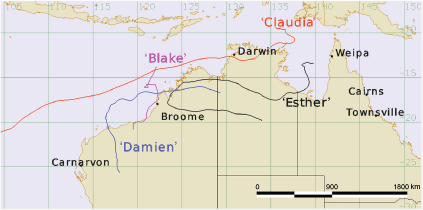
The final week of summer 2019–20 saw a weakened and indiscernible MJO. The TCs ‘Esther’ and ‘Ferdinand’ formed over northern Australian waters on 23 and 24 February respectively and developed in the absence of an active MJO pulse. ‘Esther’ was the fourth and last system to make landfall over Australia. The system was short lived but the associated very heavy rainfall as the remnant system tracked across the Northern Territory and northern Western Australia resulted in very much above average rainfall under and in vicinity of its path (Fig. 6).
Phase-space representation of the Madden–Julian Oscillation (MJO) index for summer 2019–20. Daily values are shown with January in red, February in green and December in blue. The eight phases of the MJO and the corresponding (approximate) locations of the near-equatorial enhanced convective signal are labelled.
Refer to Section 8.1 for a broader perspective on rainfall over Australia during the austral summer 2019–20.
6.SSTs and ocean patterns
The average summer SST in the southern hemisphere was 0.69°C above the 1910–2000 average.8 The SSTs were above average across much of the globe during austral summer 2019–20 (Fig. 7). The austral summer of 2015–16 recorded the highest SST anomaly on record for the southern hemisphere (at 0.76°C). Summer 2019–20 was the second warmest on record for the southern hemisphere ocean.9
Global sea-surface temperature anomaly (°C) for austral summer 2019–20 (Reynolds NCEP Global ERRSTv5).
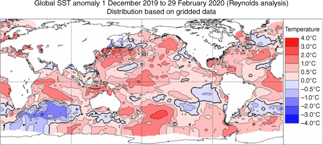
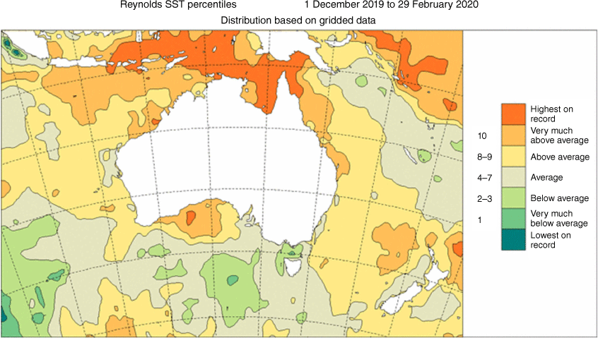
Above-average SSTs were present across much of the Indian Ocean and the maritime Australian region with record-warm summer anomalies across most of the Gulf of Carpentaria, waters surrounding eastern Indonesia as well as Papua New Guinea. Fig. 8 depicts two areas of highest-on-record SSTs for summer off Western Australia, off the south-east and north-west coasts of that state. The anomalously warm waters of the Coral and Tasman Seas (Fig. 9a–c) supported the significant polewards track of TC ‘Uesi’ and its remnant circulation. ‘Uesi’ transitioned into an extratropical system while it moved southwards and remained well offshore of the New South Wales coast, then tracked south-east towards the southern tip of New Zealand around the middle of February.
Summer 2019–20 sea-surface temperature (SST) anomalies: December 2019 (a), January 2020 (b), February 2020 (c).
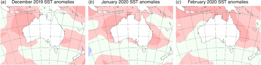
There were discernible SST anomalies over the southern Indian Ocean, which displayed the greatest negative anomalies during the season although these anomalies were greatest in December and January. The magnitude and the areal extent of these negative anomalies decreased and contracted in February. Cold upwelling and anomalously low mean sea level pressure (MSLP) in this region may have contributed to these lower-than-average SSTs. Negative SST anomalies also occurred over parts of the eastern and south-eastern Pacific Ocean as well as the south of the Atlantic Ocean.
Above-average SSTs in the Indian Ocean have continued a trend of positive anomalies that has been particularly strong since the 2010–11 La Niña (Ganter 2011; Lee et al. 2015, pp. 445–449). This ocean basin has been warming rapidly, as a direct result of climate change (CSIRO and Bureau of Meteorology 2022).
Global ocean heat content (OHC), a parameter to gauge trends in excess heat in the Earth’s system, for October–December 2019 was the highest October–December OHC, as well as the second highest quarterly OHC, according to the NOAA/NESDIS/NCEI Ocean Climate Laboratory, where data records extend back to 1955. This quarterly OHC, as well as the January–March 2020 OHC quarter, revealed widespread warmer than normal conditions (above the 1955–2006 mean), which have been observed since the end of 2016 (National Centers for Environmental Information 2019, 2020a).
7.Atmospheric circulation
7.1. SAM
The SAM, which is related to the Antarctic Oscillation (AAO), describes north–south shifts of the belt of strong westerly winds in the middle to high latitudes of the southern hemisphere,10 with positive SAM indicating a poleward shift of these winds and associated frontal systems. The SAM is known to influence temperature and rainfall patterns across Australia with varying influences across the seasons (Hendon et al. 2007).
The SAM had a significant influence early in summer, although its influence lessened into early 2020. During early to mid-December the SAM was strongly negative (Fig. 10), so the westerly winds expanded towards the equator. This led to unusually wet conditions in western Tasmania, and hotter and drier conditions for south-eastern mainland Australia, which dominated the weather in December 2019 (see Section 8.1).
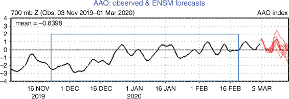
The enhanced westerly flow across central Australia channelled a record hot and dry continental airmass over the south and south-east of mainland Australia, contributing to the dangerous fire weather as detailed in Section 8.3. The SAM conditions eased to be mainly within the neutral range from late December. The combined influence of the negative SAM with other drivers on temperature and rainfall are illustrated in Section 8.1.
7.2. Surface analyses
The MSLP pattern for summer 2019–20 (Fig. 11) was computed using data from the 00:00 hours UTC daily analyses of the Bureau of Meteorology’s ACCESS model.11 The MSLP anomalies are shown in Fig. 12, relative to the 1979–2000 climatology obtained from the National Center for Environmental Prediction (NCEP) II Reanalysis data (Kanamitsu et al. 2002). The MSLP anomaly field is not shown over areas of elevated topography (grey shading).
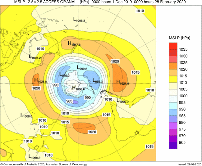
Southern hemisphere mean sea level pressure (MSLP) anomalies (hPa) for summer 2019–20. Anomalies calculated with respect to base period of 1979–2000.
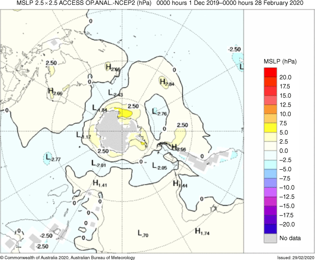
Fig. 12 depicts pressures that were abnormally low surrounding Antarctica, north to ~60°S, as well as over much of the central and eastern Pacific Ocean and across the Indian Ocean, west of 90°E. In comparison, pressure was relatively high over the Australian region and the south Pacific Ocean, with anomalies of up to +3 hPa near and to the east of New Zealand, while an area west of Chile was ~3.5 hPa above normal. The greatest positive anomaly, more than 5 hPa, was evident near the Antarctica coast between longitudes 160°E and 150°W. Negative pressure anomalies within the order of magnitude of 3 hPa were extensive across the Indian and Pacific Oceans.
Anomalously high pressure was analysed over Australia in summer 2019–20, especially in December and January, with a notable period of the absence of cold fronts and the domination of high pressure over the Tasman Sea, also consistent with the negative SAM that shifts the belt of westerly winds over the Southern Ocean towards the equator. Persisting high pressure systems over Australia allow for large reservoirs of heat to build in central parts and move over the south and south-east with favourable synoptic systems; this was a contributing factor to the heat observed in December 2020, see Section 8.1.
7.3. Mid-tropospheric analyses
The 500-hPa geopotential height is an indicator of the steering of surface synoptic systems across the southern hemisphere. The associated anomalies are shown in Fig. 13. Geopotential height is valuable for identifying and locating features like troughs and ridges that are the upper-level equivalents of surface low- and high-pressure systems respectively.
The geopotential mean (GPM) height anomalies summer 2019–20, 500 hPa, from 1979 to 2000 climatology.
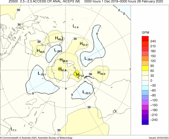
Summer 2019–20 saw above average heights over Antarctica, southern Australia and the Tasman Sea. Positive anomalies were also evident over the south central and south-east Pacific Ocean areas. The most significant positive anomalies were identified over the Antarctic continent, ~70 geopotential mean (GPM) anomalies near the South Pole and the Antarctic Peninsula. Long wave ridging (with positive Z500 anomalies ~40–50 GPM) over southern Australia, especially during December and January, influenced by the strongly negative SAM, led to the below average rainfall and very much below average root-zone soil moisture across large swathes of Australia. Negative anomalies dominated the southern Tasman Sea, the central Pacific, western and south-central parts of the Indian Ocean as well as the south-west Atlantic Ocean.
Above average heights were a feature over Antarctica as well as the southern half of Australia during December. The Climate Diagnostic Bulletin noted that a north–south dipole pattern of 200 hPa stream function anomaly was analysed over Australia during December 2019 (Climate Prediction Center 2019). High (low) stream function corresponds to low (high) geopotential height over the southern hemisphere. Over the south of the continent, anti-cyclonic anomalies were evident with cyclonic anomalies across the north. A poleward shift of the mean jet stream position to the south of Australia as well as anomalous subsidence across the eastern half of Australia accentuated these anomalies. This situation favours synoptic patterns conducive to the buildup of heat across Australia. The return to a neutral IOD and warmer than average SSTs off Australia’s north-west coast, early in 2020, favoured tropical moisture transfer southwards across the continent. This moisture interacted with cold fronts to produce above average rainfall over many areas of eastern Australia, particularly during February.
8.Australian region and the influence of the climate drivers
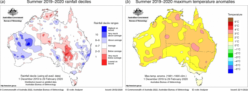
This section provides details about the rainfall, temperatures and fire weather conditions for the austral summer 2019–20. The rainfall decile and temperature anomaly maps for the season as a whole (Fig. 14) hide some of the very extreme conditions experienced on shorter timescales.
8.1. Rainfall and temperature
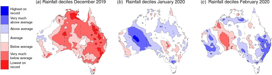
There was significant spatial and temporal variation in the rainfall during the season. Summer 2019–20 started much drier than average and finished relatively wet; the polarity of the season is well illustrated by the monthly decile plots in Fig. 15. December 2019 was the driest December on record for Australia as a whole (Bureau of Meteorology 2020a), and vast areas of Australia had very much below average rainfall to lowest rainfall on record, with only small pockets in Western Australia receiving above average rainfall (Fig. 15a). Rainfall for January and February 2020 was slightly above average nationally (Bureau of Meteorology 2020b, 2020c) with the above average rainfall concentrated in areas rather than broadly (Fig. 15b, c). These areas experienced significant, short-lived weather events – TC activity (southern Western Australia, western South Australia and Northern Territory) and a slow-moving trough followed by period of onshore flow (New South Wales and southern Queensland). The events, although short lived, were so significant that their overall contribution to the seasonal rainfall negated the longer dry periods of the season.
Rainfall deciles for summer 2019–20 by month. Decile ranges based on grid-point data with respect to all available data 1900–2020: December 2019 (a), January 2020 (b), February 2020 (c).
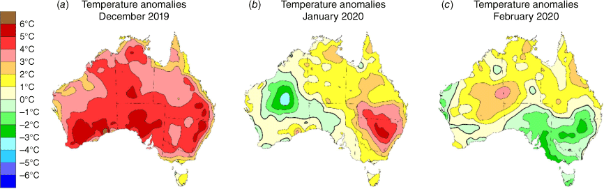
Similarly, summer 2019–20 was a summer of temperature extremes, both hot and cold. Although there were cool periods with record low summer maximum and minimum temperatures recorded in some parts, it was Australia’s second warmest summer on record (second to summer 2018–19). The national mean maximum temperature was 2.11°C above average, the mean minimum temperature was 1.64°C above average and the mean temperature was 1.88°C above average (Bureau of Meteorology 2020d).
As outlined in Sections 3 and 7.1, the two main drivers for December were the lingering positive IOD and the negative SAM (as MJO was weak). The plots in Fig. 17 illustrate the extent to which these drivers influenced the rainfall and temperature for December, following the method of Hope et al. (2022).
Temperature anomalies for summer 2019–20. Anomalies based on available data 1900–2020: Decembr 2019 (a), January 2020 (b), February 2020 (b).
Driver influence on December 2019 rainfall (a) and maximum temperature (b). Provided by Dr Roseanna McKay at the Bureau of Meteorology as early work in the Climate Services for Agriculture project.
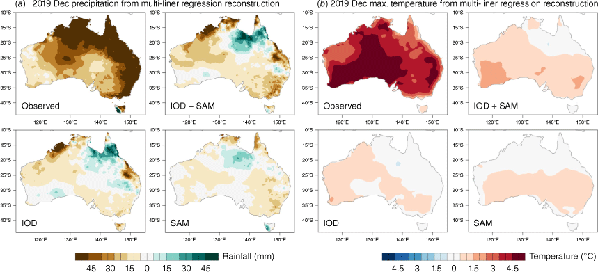
In each of the plots in Fig. 17, the observed values are in the top left and the composite influence of the two main drivers that contributed are on the top right. On the bottom row is influence that can be attributed to the individual drivers.
December 2019 rainfall shows that much of the dry area (although not quite the magnitude) corresponds to regions that would be expected to be drier due to IOD and SAM; even the wetter signal for western Tasmania is indicated by the IOD + SAM plot. Two regions, however, experienced conditions opposite to what would be expected from IOD and SAM alone: the gulf coast and southern Cape York region, and the Queensland and New South Wales border region. The results of Koster et al. (2004) suggest that we expect soil moisture to influence precipitation in the zones between a wet and dry climate, where evaporation is suitably high but still sensitive to soil moisture, and in tropical regions. It is therefore reasonable to assume that the significant rainfall deficiencies in the lead up to December over those two regions (Fig. 18a) had the positive feedback effect of continuing dry conditions, despite the climate influences. This influence may also have contributed to the higher magnitude of rainfall suppression than would have been expected from only the IOD and SAM influences. There were significant rainfall events around south-east Queensland in mid-December, which led to flash flooding, including metropolitan Brisbane, with heavy rainfall and giant hail observed in several locations. These short-lived events were not enough to result in near average rainfall for December, nor to significantly reduce the rainfall deficiencies in that region.
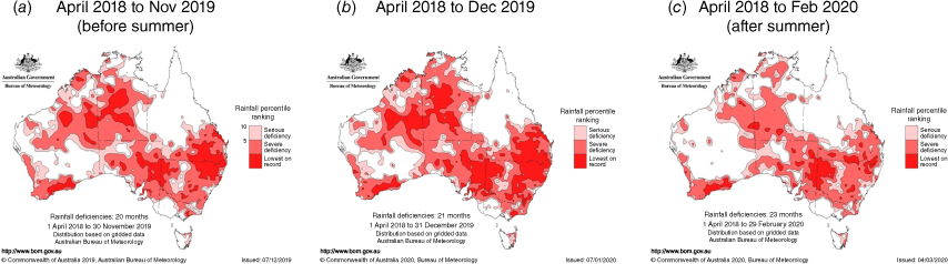
Rainfall deficiencies for the periods around summer: before summer (a), end of December 2019 (b), end of summer (c).
Similar to rainfall, most of the area of above average temperatures can be attributed to the influence of the IOD and SAM (Fig. 17). The record for Australia’s hottest day was set on both 17 and 18 December. The national area-averaged temperature record of 40.7°C set on 17 December (previous record 40.3°C on 7 January 2013) was broken the next day by a national area-averaged temperature of 41.9°C. The week ending 24 December was Australia’s hottest week on record (Bureau of Meteorology 2020a). Arguably, the unusual persistence of the positive IOD into December was a foundational influence enabling the warmest December in 110 years of records in Australia. Interestingly, the observations around the gulf coast and southern Cape York region also differed to the expected influence, as with rainfall. An absence of any significant synoptic feature leads us to consider that this may again be linked to the rainfall deficiencies leading to reduced precipitation (and so cloud cover) and therefore anomalously high maximum temperatures. In Fig. 3 there are high OLR anomalies at 140°E for December, and Fig. 4 supports this conclusion. The spatial signature of anomalies is consistent with the natural climate drivers, but the size of anomalies is much larger than might be expected. Climate change was a clear underlying factor in the magnitude of the anomalies. Australia has warmed, on average, by 1.47 ± 0.24°C since national records began in 1910 and there has been an increase in extreme heat events associated with the warming (CSIRO and Bureau of Meteorology 2022).
Near the end of December, the IOD and SAM both moved into neutral phases; once these more significant drivers ceased to dominate, the influence of more localised drivers became apparent. Stochastic weather processes dominated in January and February, supported by warm ocean waters and the MJO. Elevated SSTs to the north of Australia are known to increase the availability of moisture for rainfall and with SAM now neutral, mid-latitude low pressure systems were able to penetrate further north, tap into the extra available moisture and deliver significant, though short lived, rainfall and tropical conditions further south. There was a significant heatwave across south-eastern Australia in late January and early February, but heat was no longer able to build and linger on a continental scale. Average to cooler conditions prevailed through the end of the summer for the south-east of Australia while heat continued in the Australian tropics.
Consistent with these patterns, the January and February rainfall deciles and temperature anomalies in plots (b) and (c) of Fig. 15 and 16 respectively show a general overlap in areas that experienced warm and dry, and cool and wet conditions. This reinforces the strong influence of the dynamical systems on the Australian region in January and February – the synoptic patterns support the displacement of the inland heat over areas adjacent the movement of cyclones.
Much of the significant rainfall for January and February was associated with TCs, ex-TCs or mid-latitude low pressure systems. Above-average rainfall in north-eastern New South Wales and south-eastern Queensland brought substantial relief for areas experiencing significant bushfires in January.
For January, the most significant contribution to the Australia-wide above-average rainfall was associated with TC ‘Blake’ as it made landfall in Western Australia and moved southward as it decayed over the main blue area, seen in Fig. 15b for January deciles, with totals so significant they are still reflected in Fig. 14a for the full season decile. The tropical low, which would develop into TC ‘Claudia’, also brought significant rainfall to the Northern Territory (see Section 5) but the prevailing dry conditions in early January negated the impact of this rainfall in the decile plot.
Two other areas of above average rainfall in January were also linked to dynamic systems. A vigorous mid-latitude system later in the month linked with the heat trough to funnel tropical moisture over the region again. That system continued to deliver fresh conditions and rainfall to eastern Victoria. A near stationary low around the gulf coast region in the Northern Territory and Queensland for the last week of January provided the mechanism to deliver significant rainfall to that region.
In February, TCs ‘Damien’ and ‘Esther’ contributed to the above average rainfall through the west and north respectively. A band of tropical moisture drawn down through central South Australia and around to Victoria brought significant rainfall early in February, with some stations in South Australia recording daily rainfall records (Bureau of Meteorology 2020c). Above average rainfall across central and eastern New South Wales and south-eastern Queensland was welcome relief for the areas still affected by bushfire activity and contributed to the reduction of long-term rainfall deficiencies. A slow-moving trough and low moving across eastern New South Wales in the second week of February enhanced the rainfall in the east, evident on the rainfall deciles map for February. Riverine and flash flooding resulted in some areas. An extended period of onshore flow on the east coast (including northern Tasmania) from mid-February, supported by anomalously warm SSTs and the passage of TC ‘Uesi’ to the east, also created the environment for continual shower activity that contributed to the significantly above average monthly totals. Although the SAM values remained within the neutral range, the primarily positive values persisting through most of February could have been a contributing factor to the significant rainfall in the far south-east for the end of summer, due to the increased easterly onshore flow.
8.2. Rainfall deficiencies
Summer 2019–20 started with record lowest national rainfall for December. Rainfall for the first half of December was suppressed due to a strong positive IOD continuing to influence rainfall over Australia in December (more details in Sections 1.1 and 8.1) and a positive SAM (Section 7.1). Images show the rainfall deficiencies at the start of summer (Fig. 15a), at the end of December 2019 (Fig. 15b) and at the end of summer 2019–20 (Fig. 15c). The sequence of images in Fig. 18 shows that the drought conditions were exacerbated by the dry December and then eased by the rainfall during January and February.
Although many areas saw above-average rainfall in either January or February, the below average rainfall throughout the other periods of summer generally cancelled out the potential reduction in deficiencies, except for regions that experienced significant rainfall events. Persisting dry conditions throughout summer in western New South Wales and the bordering South Australian and Queensland regions resulted in the drought conditions being further exacerbated in those regions. The rainfall brought by TC ‘Esther’ significantly improved the conditions in central Northern Territory but conditions across the north and south worsened. Likewise, TCs ‘Damian’ and ‘Blake’ helped alleviate long-term rainfall deficiencies through central Western Australia. February rain in eastern New South Wales and south-eastern Queensland helped contract deficiencies.
The significant and widespread rainfall deficits in South Australia, Northern Territory, inland New South Wales and Southern Queensland would require a long period of above average rainfall to recover. The 36-month rainfall deficiencies to February 2020 averaged over the Murray–Darling Basin and New South Wales is the driest such period on record (Bureau of Meteorology 2020e).
8.3. Fire weather
Summer 2019–20 is now widely referred to as ‘Black Summer’ due to the unprecedented extent and severity of fire activity predominately during the first part of the season (and the end of the preceding spring), and since Black Summer is in relation to the globally significant fires, the more appropriate period it refers to is September–December 2019.
Spring 2019 was the driest on record nationally (Bureau of Meteorology 2019a) and the dry conditions persisted into the first half of summer 2019–20. Prolonged periods of heat were followed by shorter cool periods, brought about by changes associated with vigorous cold fronts. The combination of dry, hot and windy conditions resulted in high FFDI.12 The dry and hot conditions leading into the summer preconditioned fuels to be conducive to fires, and the extreme fire weather of early summer supported vigorous fire activity over broad areas.
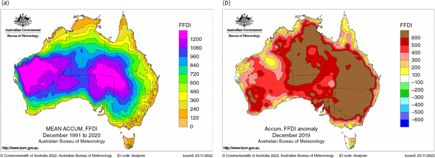
The most dangerous fire weather conditions were from December until early January (Bureau of Meteorology 2020f). The severe rainfall deficiencies (outlined in Section 8.2) contributed to dry fuels across more regions, including forest in tropical and sub-tropical regions usually too wet to burn. The antecedent conditions were conducive for a bad fire weather season. National annual accumulated FFDI for 2019 was the highest since 1950 (when national records began) and December 2019 monthly accumulated FFDI for Australia was the highest on record. The record for highest accumulated FFDI for any month was set for Queensland, New South Wales (and ACT) and South Australia (Bureau of Meteorology 2020f). Fig. 19 shows the average accumulated FFDI for December 2019 on the left, and the anomalies on the right; most of Australia recorded accumulated FFDI anomalies of 400 and over. Catastrophic (or code red: FFDI values 100 and above) fire weather conditions were observed in all mainland states and the Northern Territory; many areas observed days with their highest FFDI value on record.
Mean accumulated FFDI for December, calculated over the period 1981–2010 (a). The accumulated anomaly (with respect to the mean) for December 2019 (b).
Fire weather conditions eased across the country generally from mid-January, though FFDI remained elevated in south-western New South Wales, north-eastern Victoria, eastern Tasmania and south-western Western Australia until early February. Unusually intense fires burnt in each state and territory, with the most affected area in the south and east of the mainland. Extensive areas of smoke caused air quality to drop to hazardous levels across most southern states, including the major population centres (Climate Council 2020). An air quality index value of 2552 was recorded in western Sydney, more than 12 times the hazardous level of 200 (Dockrill 2019). Smoke also travelled across the Tasman Sea and southern Pacific Ocean as far as New Zealand, Chile and Argentina (Reuters 2020). Although the fires were directly linked to 33 deaths, the estimated number of deaths due to smoke inhalation was ~445 people with over 80% of the Australian population affected by bushfire smoke at some time during the 2019–20 bushfire season (Hitch 2020). The IPCC report (Lawrence et al. 2022) summarised the ecological impacts of the 2019–20 south-east wildfires as 5.8 × 10⁶ to 8.1 × 10⁶ ha burnt, 114 listed threatened species losing at least half of their habitat and 49 losing over 80%. The human impacts included the 33 people killed, a further 429 deaths and 3230 hospitalisations due to cardiovascular or respiratory conditions, and over 3000 houses destroyed. A total estimate of losses was given as A$1.95 billion in health costs, A$2.3 billion in insured losses and A$3.6 billion in losses for tourism, hospitality, agriculture and forestry.
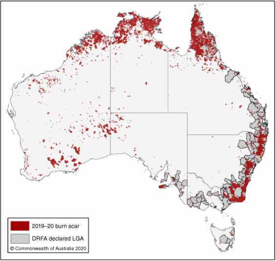
Rainfall during early February helped in the management of bushfires across eastern Australia, with all fires declared contained in New South Wales, Victoria and Tasmania by the end of February. Some fires were still burning within containment lines in the south of New South Wales, the ACT and eastern Victoria. The extent of the fire was shown as part of the Royal Commission that followed the season (Fig. 20).13
2019–20 burn scar. Source: https://naturaldisaster.royalcommission.gov.au/system/files/exhibit/RCN.900.008.0001_2.pdf.
9.Overview of southern hemisphere weather impacts
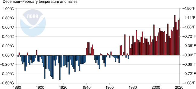
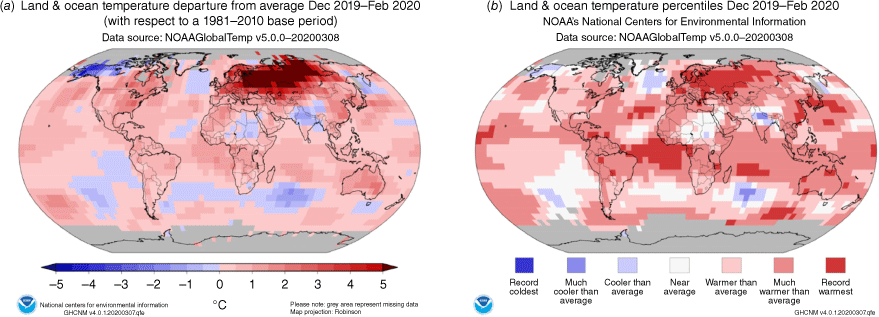
The austral summer of 2019–20 was significantly warmer than average over much of the southern hemisphere. Looking at the ranking of years 1880–2020, it was the third-warmest summer for land (with an anomaly of 1.33°C) and second warmest for land and ocean combined, with an anomaly of 0.79°C (Fig. 21). The ocean area was no different with an anomaly of 0.69°C, and this ranked as the second warmest out of 140 years. Summer SSTs were the warmest on record in 2015–16 in the southern hemisphere (Pepler 2016).
December 2019 saw warmer than usual temperatures in South America and Africa. South America had its second highest temperature departure from average on record in January whereas the continent had its fourth-warmest February on record. South America and Oceania had a near-record warm December–February, falling behind 2016 and 2019 respectively.
The World Meteorological Organisation confirmed a highest on record temperature for Antarctica at Argentina’s Esperanza Base, with a maximum temperature of 18.4°C on 6 February 2020. The previous record was 17.5°C, also recorded at Esperanza on 24 March 2015. Records for this location began in 1961. Marambio is also an Argentinian base, and both bases are located on the tip of Graham Land on the Antarctic Peninsula. A new record for February was reached at Marambio with a temperature of 15.7°C, also on 6 February 2020. This surpassed the previous record of 13.8°C on 24 February 2013 (National Centers for Environmental Information 2020b).
The warmer than average conditions continued across sub-equatorial South America with the second highest departure from average in January on record. It was a similar story in February with the continent having its fourth warmest on record. A continent-wide anomaly of +1.37°C was analysed for South America in January. Only January 2016 saw a greater positive anomaly of ~2.0°C (National Centers for Environmental Information 2016). Fig. 21 shows warmer than average conditions in the sub-equatorial areas of both South America and Africa. By contrast, below to much-below average SSTs occurred off the coast from southern Brazil and Argentina and adjacent to South Africa.
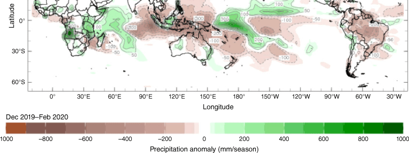
Gomes et al. (2021) documented the Sudden Stratospheric Warming (SSW) event that occurred in September 2019, leading to a negative SAM at the beginning of the austral 2019–20 summer. This in turn generated widespread subsidence over the subtropics, which affected precipitation over South America. The report on the drought impacts on South America from Gomes et al. discusses the heating observed in the stratosphere, which propagated to the troposphere over South America in September 2019 to March 2020. Significant negative precipitation anomalies were evident over Brazil, far northern Australia, parts of Oceania, most of Indonesia and parts of eastern Africa (Fig. 22).
Global land and ocean anomaly (a) and global land and ocean temperature percentiles (b) for austral summer 2019–20.
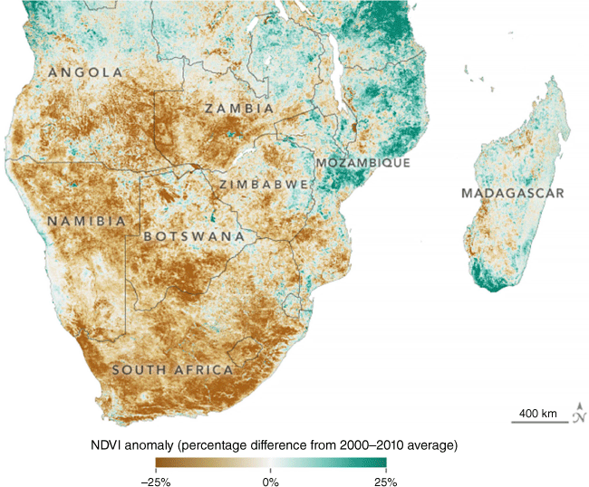
Nine TCs formed in the Indian Ocean Basin between December 2019 and February 2020 (National Centers for Environmental Information 2021). The most damaging was TC ‘Belna’, which made landfall in northern Madagascar on 9 December causing extensive structural damage, inundation and nine fatalities with thousands injured (Tetaud 2019). Heavy rainfall and flooding also affected Mauritius at the end of December as TC ‘Calvinia’ stalled near the island nation. Severe drought and flooding dominated southern Africa at the end of 2019. Several countries recorded their driest seasons since 1981. Major flooding late in 2019 resulted in significant crop damage and a serious food crisis around parts of southern Africa (GEOGLAM 2020). Low water levels in the Zambezi River caused a depletion of fish stocks and very low stream flow over Victoria Falls, which in turn affected hydroelectric power generation at Lake Kariba, with water levels at their lowest in more than two decades. Fig. 23 is the Normalised Difference Vegetation Index (NDVI) anomaly map, based on data from Terra MODIS. The ‘dry season’ of September to early December in 2019 compared with the 2000–10 average showed a large proportion of southern Africa with a negative NDVI anomaly (Fig. 24; NASA Earth Observatory 2019).
Three-month seasonal precipitation anomalies in units of millimetres per season based upon precipitation estimates from the CAMS_OPI dataset. Green areas on the map indicate where precipitation was above the long-term normal for the season, and brown areas on the map indicate where precipitation was below normal. Contours are depicted at increments of ±50, 100, 200 and 1000 mm per season. Source: International Research Institute for Climate and Society, see https://iridl.ldeo.columbia.edu/maproom/Global/Precipitation/Seasonal.html?T=Dec%202019%20-%20Feb%202020 (accessed 23 March 2020).
Normalised Difference Vegetation Index (NDVI) anomaly for southern Africa for 10 September to 8 December 2019.
January rainfall was very much above average in Tanzania, northern Mozambique and northern Madagascar. Areas in northern and southern South Africa and across large parts of Angola saw higher than average January rainfall. There were significant impacts in Mozambique and Madagascar where there were scores of fatalities and over 100 000 displaced.14 Flash flooding occurred in the normally dry areas of western Zimbabwe and southern Zambia during 15–19 January. Meteorological agencies reported 109 mm in a 24-h period at Gwembe (Zambia) on 15 January and Nkayi (Zimbabwe) recorded 124 mm on 18 January. Further flooding ravaged Zambia towards the last week of January, leaving scores dead and affecting thousands of people in the country’s Eastern Province. Flooding in this region commenced in late December 2019.
Numerous flooding events occurred over sub-equatorial Africa including widespread flooding in Malawi (also affecting the capital, Lilongwe, in the last week of February). Floods and landslides also caused loss of life in Kigali, Rwanda, in the first few days of February. Severe flooding also affected Burundi, Tanzania and South Africa during February.
December to February also saw several heavy rain, flood and landslide events in Peru. Flooding blocked roads, interrupted drinking water supply, damaged crops and led to several fatalities. Sao Paulo State in southern Brazil recorded torrential rain, causing some rivers to break their banks c. 10 February. Thunderstorm activity c. 18–19 February caused the San Antonio River (in northern Argentina) to break its banks causing flooding, evacuations and one fatality.
Oceania recorded several flooding events as well as impacts from TC activity. The TC ‘Sarai’ caused cancellation of domestic and international flights in Fiji, Tonga, Niue and the Cook Islands. The impacts were greatest in Fiji with widespread flash flooding and two fatalities during the last week of December. The TC ‘Uesi’ cut power and dumped torrential rain on parts of New Caledonia c. 11–12 February whereas TCs ‘Vicky’ and ‘Wesi’ spun up to the east of Fiji on 21 February, affecting American Samoa and Niue where large waves led to some coastal inundation. Six tropical cyclones formed in the south-west Pacific Basin during the austral summer 2019–20.
Flash flooding left communities in the Eastern Highlands Province of Papua New Guinea without homes and livelihoods c. 12–13 January whereas the Western Highlands Province and more specifically the communities around the Kuma River were severely affected on 3 February 2020. Despite Indonesia generally having below average rainfall (2019 was the fourth-driest year since records commenced in 1981), monsoon rains and flooding caused landslides and fatalities in Indonesia in January (Jakarta) and February (Yogyakarta) when a flash flood affected a school group hiking on Indonesia’s main island of Java.
For the period 1–4 February, MetService New Zealand recorded over 1000 mm of rain at Milford Sound, with 600 mm in 24 h to early 4 February, resulting in severe flooding around this part of the country. Also of significance was heavy rainfall and flooding c. 5–6 December in the Canterbury Region, when flooding and landslides blocked roads stranding hundreds of people in Fox and Franz Josef Glaciers.15 Several locations across the nation had a record or near-record warm February, and February 2020 was drier than average across much of New Zealand. According to NIWA, several locations set a record for longest dry spell while severe meteorological drought was widespread across parts of northern New Zealand in February 2020.
10.Conclusion
The austral summer of 2019–20 comprised two quite markedly different periods. The first month had record heat, widespread drought with dry conditions and unprecedented fire weather. The second half saw much better rainfall, cooler temperatures and reduced fire weather. This shift in pattern occurred with the demise of a strong positive IOD and a shift from strongly negative to neutral SAM. It was significantly warmer than average over the southern hemisphere with notable contrasts between drought and heavy rainfall in many regions – southern and eastern Africa as well as New Zealand experienced the greatest extent of this variability. This summer comprised two quite distinct ‘seasons’ for the Australian region. For the early part of the summer, climate drivers were strong and dominated, and observed outcomes were in line with expected outcomes based on the drivers’ influences. The second part of the season was highly dynamic and changeable.
Acknowledgements
The authors thank Ben Hague and Katie Rosemond (both Bureau of Meteorology) for reviewing an earlier manuscript; their comments provided an opportunity to significantly improve the manuscript. Thanks to Dr Roseanna McKay for reviewing and creating the plots for Fig. 17. Dr Blair Trewin is thanked for his patience.
References
Bureau of Meteorology (2019a) Australia in spring 2019. (BOM) Available at http://www.bom.gov.au/climate/current/season/aus/archive/201911.summary.shtml
Bureau of Meteorology (2019b) Special Climate Statement 71—severe fire weather conditions in southeast Queensland and northeast New South Wales in September 2019. (BOM) Available at http://www.bom.gov.au/climate/current/statements/scs71.pdf
Bureau of Meteorology (2020a) Australia in December 2019. (BOM) Available at http://www.bom.gov.au/climate/current/month/aus/archive/201912.summary.shtml
Bureau of Meteorology (2020b) Australia in January 2020. (BOM) Available at http://www.bom.gov.au/climate/current/month/aus/archive/202001.summary.shtml
Bureau of Meteorology (2020c) Australia in February 2020. (BOM) Available at http://www.bom.gov.au/climate/current/month/aus/archive/202002.summary.shtml
Bureau of Meteorology (2020d) Australia in summer 2019–20. (BOM) Available at http://www.bom.gov.au/climate/current/season/aus/archive/202002.summary.shtml
Bureau of Meteorology (2020e) Drought. Rainfall deficiencies and water availability. (BOM) Available at http://www.bom.gov.au/climate/drought/archive/20200305.archive.shtml
Bureau of Meteorology (2020f) Special Climate Statement 73—extreme heat and fire weather in December 2019 and January 2020. (BOM) Available at http://www.bom.gov.au/climate/current/statements/scs73.pdf
Climate Council (2020) Air quality: what you need to know (Climate Council) Available at https://www.climatecouncil.org.au/resources/air-quality/ [Verified 29 July 2020]
Climate Prediction Center (2019) Climate Diagnostic Bulletin, December 2020, near real-time ocean/atmosphere, monitoring, assessments, and prediction. (US Department of Commerce, NOAA, National Weather Service National Centers for Environmental Prediction) Available at https://www.cpc.ncep.noaa.gov/products/CDB/CDB_Archive_pdf/PDF/CDB.dec2019_color.pdf
CSIRO and Bureau of Meteorology (2022) State of the Climate 2022. (Bureau of Meteorology) Available at http://www.bom.gov.au/state-of-the-climate/2022/documents/2022-state-of-the-climate-web.pdf
Dockrill P (2019) Fires in Australia just pushed Sydney’s air quality 12 times above ‘hazardous’ levels. In Science Alert, 11 December 2019. Available at https://www.sciencealert.com/sydney-air-soars-to-12-times-hazardous-levels-under-toxic-blanket-of-bushfire-smoke [Verified 31 July 2020]
Donald A, Holger M, Brendan P, et al. (2004) Forecasting with the Madden–Julian Oscillation and the applications for risk management. In ‘Proceedings of the 4th International Crop Science Congress (ICSC 2004)’, 26 September–1 October 2004, Brisbane, Qld, Australia. (Eds T Fischer, N Turner, J Angus, L McIntyre, M Robertson, A Borrell, D Lloyd) Paper 1362. (The Regional Institute Ltd: Gosford, NSW, Australia) Available at http://www.cropscience.org.au/icsc2004/poster/2/6/1362_donalda.htm
ET Bureau (2019) Monsoon begins withdrawal on October 9, the most delayed in its recorded history! In The Economic Times, 9 October 2019. Available at https://economictimes.indiatimes.com/news/politics-andnation/monsoon-begins-withdrawal-on-october-9-the-most-delayed-inits-recorded-history/articleshow/71504213.cms
FloodList (2020) Updated: New Zealand – emergency declared after floods in Southland. In Floodlist News, 4 February 2020. Available at https://floodlist.com/australia/new-zealand-floods-southland-february-2020
Ganter C (2011) Seasonal climate summary for the southern hemisphere (winter 2010): a fast developing La Niña. Australian Meteorological and Oceanographic Journal 61, 125-135.
| Google Scholar |
GEOGLAM (2020) Early Warning. In Crop Monitor 46(February). Available at https://reliefweb.int/sites/reliefweb.int/files/resources/EarlyWarning_CropMonitor_202002.pdf
Gomes MS, Cavalcanti IFA, Müller GV (2021) 2019/2020 drought impacts on South America and atmospheric and oceanic influences. Weather and Climate Extremes 34, 100404.
| Crossref | Google Scholar |
Hendon HH, Thompson DWJ, Wheeler MC (2007) Australian rainfall and surface temperature variations associated with the Southern Hemisphere Annular Mode. Journal of Climate 20(11), 2452-2467.
| Crossref | Google Scholar |
Hitch G (2020) Bushfire royal commission hears that Black Summer smoke killed nearly 450 people. In ABC News, 26 May 2020. Available at https://www.abc.net.au/news/2020-05-26/bushfire-royal-commission-hearings-smoke-killed-445-people/12286094 [Verified 28 March 2023]
Hope P, Zhao M, Abhik S, et al. (2022) Subseasonal to seasonal climate forecasts provide the backbone of a near-real-time event explainer service. Bulletin of the American Meteorological Society 103, S7-S13.
| Crossref | Google Scholar |
Jones DA, Wang W, Fawcett R (2009) High-quality spatial climate data-sets for Australia. Australian Meteorological and Oceanographic Journal 58, 233-248.
| Google Scholar |
Kanamitsu M, Ebisuzaki W, Woollen J, et al. (2002) NCEP-DOE AMIP-II reanalysis (R-2). Bulletin of the American Meteorological Society 83(11), 1631-1644.
| Crossref | Google Scholar |
Koster RD, Dirmeyer PA, Guo Z, et al. (2004) Regions of strong coupling between soil moisture and precipitation. Science 305, 1138-1140.
| Crossref | Google Scholar |
Kuleshov Y, Qi L, Fawcett R, Jones D (2009) Improving preparedness to natural hazards: tropical cyclone seasonal prediction for the Southern Hemisphere. Advances in Geosciences 12, 127-143.
| Crossref | Google Scholar |
Lawrence J, Mackey B, Chiew F, Costello MJ, Hennessy K, Lansbury N, Nidumolu UB, Pecl G, Rickards L, Tapper N, Woodward A, Wreford A (2022) Australasia. In ‘Climate Change 2022: Impacts, Adaptation and Vulnerability. Contribution of Working Group II to the Sixth Assessment Report of the Intergovernmental Panel on Climate Change’. (Eds H-O Pörtner, DC Roberts, M Tignor, ES Poloczanska, K Mintenbeck, A Alegría, M Craig, S Langsdorf, S Löschke, V Möller, A Okem, B Rama) pp. 1581–1688. (Cambridge University Press: Cambridge, UK, and New York, NY, USA), 10.1017/9781009325844.013
Lee S-K, Park W, Baringer MO, et al. (2015) Pacific origin of the abrupt increase in Indian Ocean heat content during the warming hiatus. Nature Geoscience 8, 445-449.
| Crossref | Google Scholar |
Madden RA, Julian PR (1971) Detection of a 40–50 day oscillation in the zonal wind in the tropical Pacific. Journal of the Atmospheric Sciences 28, 702-708.
| Crossref | Google Scholar |
Madden RA, Julian PR (1972) Description of global-scale circulation cells in the tropics with a 40–50 day period. Journal of the Atmospheric Sciences 29, 1109-1123.
| Crossref | Google Scholar |
Madden RA, Julian PR (1994) Observations of the 40–50 day tropical oscillation—a review. Monthly Weather Review 122, 814-837.
| Crossref | Google Scholar |
NASA Earth Observatory (2019) Drought threatens millions in Southern Africa. (NASA) https://earthobservatory.nasa.gov/images/146015/drougth-threatens-millions-in-southernafrica [Verified 20 December 2020]
National Centers for Environmental Information (2016) January 2016 Global Climate Report. (NOAA) Available at https://www.ncei.noaa.gov/access/monitoring/monthly-report/global/201601
National Centers for Environmental Information (2019) December 2019 Global Climate Report. (NOAA) Available at https://www.ncei.noaa.gov/access/monitoring/monthly-report/global/201912
National Centers for Environmental Information (2020a) March 2020 Global Climate Report. (NOAA) Available at https://www.ncei.noaa.gov/access/monitoring/monthly-report/global/202003
National Centers for Environmental Information (2020b) Annual 2020 Global Climate Report. (NOAA) Available at https://www.ncei.noaa.gov/access/monitoring/monthly-report/global/202013#gtemp
National Centers for Environmental Information (2021) Annual 2020 Tropical Cyclones Report. (NOAA) Available at https://www.ncei.noaa.gov/access/monitoring/monthly-report/tropical-cyclones/202013
Pepler AS (2016) Seasonal climate summary southern hemisphere (summer 2015-16): strong El Niño peaks and begins to weaken. Journal of Southern Hemisphere Earth Systems Science 66, 361-379.
| Crossref | Google Scholar |
Reuters (2020) Australian bushfire smoke affecting South America, UN reports. In The Guardian, 8 January 2020. Available at https://www.theguardian.com/australia-news/2020/jan/07/australian-bushfire-smoke-drifts-to-south-america-un-reports [Verified 29 July 2020]
Saji NH, Goswami BN, Vinayachandran PN, Yamagata T (1999) A dipole mode in the tropical Indian Ocean. Nature 401, 360-363.
| Crossref | Google Scholar |
Tetaud S (2019) Cyclone hits Madagascar, killing 2 and making 1,400 homeless. In AP News, 11 December 2019. Available at https://apnews.com/article/64af1a7ef302d9445ac7c8656deeda74 [Verified 23 January 2020]
Troup AJ (1965) The ‘Southern Oscillation’. Quarterly Journal of the Royal Meteorological Society 91, 490-506.
| Crossref | Google Scholar |
Wheeler MC, Hendon HH (2004) An all-season real-time multivariate MJO Index: development of an index for monitoring and prediction. Monthly Weather Review 132, 1917-1932.
| Crossref | Google Scholar |
Footnotes
1 For more information on the Bureau of Meteorology’s ACCESS model, see http://http://www.bom.gov.au/nwp/doc/access/NWPData.shtml.
2 For more information on ACORN-SAT version 2, see http://www.bom.gov.au/climate/change/acorn-sat/documents/BRR-032.pdf.
3 For more information, please visit NCEI’s Global Surface Temperature Anomalies page, see https://www.ncei.noaa.gov/access/monitoring/global-temperature-anomalies.
4 The Troup Southern Oscillation Index (Troup 1965) used in this article is 10 times the standardised monthly anomaly of the difference in mean sea level pressure (MSLP) between Tahiti and Darwin. The calculation is based on 60-year climatology (1933–92), with records commencing in 1876. The Darwin MSLP is provided by the Bureau of Meteorology, and the Tahiti MSLP is provided by Météo France inter-regional direction for French Polynesia.
5 ENSO 5VAR was developed by the Bureau of Meteorology and is described in Kuleshov et al. (2009). The principal component analysis and standardisation of this ENSO index is performed over the period 1950–99.
6 For more information on how the Indian Ocean influences on Australian climate, see http://www.bom.gov.au/climate/iod/.
7 For more information on the Madden–Julian Oscillation (MJO), see http://www.bom.gov.au/climate/mjo/.
8 SST anomalies from https://www.ncdc.noaa.gov/monitoring-references/faq/anomalies.php.
9 Southern Hemisphere Ocean Temperature Anomaly Rankings, see https://www.ncdc.noaa.gov/cag/global/rankings/shem/ocean/.
10 For more information on the SAM index from the Climate Prediction Center (NOAA) see http://www.cpc.ncep.noaa.gov/products/precip/CWlink/daily_ao_index/aao/aao.shtml.
11 For more information on the Bureau of Meteorology’s ACCESS model, see http://www.bom.gov.au/nwp/doc/access/NWPData.shtml.
12 The FFDI can be considered a measure of the difficulty of suppressing fires, it is calculated from the temperature, wind speed at 10-m height, relative humidity and drought factor – how dry (ready to burn) the vegetation is.
13 The Royal Commission into National Natural Disaster Arrangements Report, see https://naturaldisaster.royalcommission.gov.au/.
14 Reporting floods and flooding news since 2008, http://floodlist.com/africa/page/6 (accessed 23 August 2020).
15 Reporting floods and flooding news since 2008, see http://floodlist.com/australia/new-zealand-floods-southland-february-2020 (accessed 24 August 2021).