

Factors that drive koala roadkill: an analysis across multiple scales in New South Wales, Australia
Daniel Lunney A B C * , Martin Predavec D , Indrie Sonawane A , Chris Moon E and Jonathan R. Rhodes F
A Department of Planning and Environment, Locked Bag 5022, Parramatta, NSW 2124, Australia.
B Faculty of Science, School of Life and Environmental Sciences, University of Sydney, NSW 2006, Australia.
C Australian Museum, 1 William Street, Sydney, NSW 2010, Australia.
D Mount Simpson Track, Bucketty, NSW 2250, Australia.
E 15 Ficus Street, Katoomba, NSW 2780, Australia.
F School of Earth and Environmental Sciences & Centre for Biodiversity and Conservation Science, The University of Queensland, Brisbane, Qld 4072, Australia.
Australian Mammalogy 44(3) 328-337 https://doi.org/10.1071/AM21040
Submitted: 31 October 2021 Accepted: 20 November 2021 Published: 10 February 2022
© 2022 The Author(s) (or their employer(s)). Published by CSIRO Publishing on behalf of the Australian Mammal Society. This is an open access article distributed under the Creative Commons Attribution-NonCommercial-NoDerivatives 4.0 International License (CC BY-NC-ND)
Abstract
A challenge to understanding the impacts of roads on koalas is that their effects operate across multiple scales. To determine what conditions underlie koala roadkill, we looked at koala roadkill at two spatial scales – the entire state of NSW, and a local government area (Coffs Harbour) – for three road types (primary, arterial and local). We also subdivided the state data into three regions – coast, tableland and inland – to look at regional differences. Our analyses show that koala roadkill is ubiquitous across the distribution of koalas. Similar numbers of roadkilled koalas were recorded on each road type, but because of the vastly different total length of roads in the three types (local roads 122 755 km; arterial 79 706 km; primary 12 972 km) it is clear that an individual koala is more likely to be killed on a primary road than the other two road types. The pattern shown at the LGA scale is similar to that seen across the state. Habitat type adjacent to a road appears to have little influence on the likelihood of a koala being killed on the road. Mitigation measures can reduce koala roadkill, but there is a need to correctly assess the relative importance of koala roadkill compared with other factors that impact on koala populations when allocating resources to koala conservation. We conclude that roadkill is an ever-present threat which will remove an ever-increasing proportion of decreasing koala populations in NSW.
Keywords: coffs harbour, highways, koala, mitigation, monitoring, Phascolartos cinereus, road ecology, roadkill, threatened species, vehicle collisions.
Introduction
Both in Australia and internationally, research into wildlife roadkill since the latter part of the 20th century has been perceptive and encouraging (Harris et al. 2008; Hobday and Minstrell 2008; Ramp and Roger 2008; Fahrig and Rytwinski 2009; Beckman et al. 2010; McCall et al. 2010; Taylor and Goldingay 2010; Jones et al. 2011, 2014; Roger et al. 2011, 2012; Jones 2012; Bond and Jones 2013; Lunney 2013; Soanes et al. 2017; Grueber et al. 2018; Santori et al. 2018; Ascensão et al. 2019; Fox et al. 2019), with Forman (2010) declaring that road ecology now reaches across much of the globe.
The koala (Phascolarctos cinereus) is listed as a threatened species under both New South Wales (NSW) and Commonwealth legislation, with the Commonwealth actively considering uplisting the koala to endangered (DAWE 2021a). Roadkill is recognised as a threat to koalas (DECC 2008; Commonwealth of Australia 2009, 2011; Shumway et al. 2015; OEH 2018; EES 2019; DAWE 2021b). A parliamentary inquiry (Parliament of NSW 2020, 4.1, p. 63) reported that, ‘Throughout the inquiry, many stakeholders told the committee that a key threat to local koala populations were roads, traffic and vehicle strikes.’ DPIE (2020a, 2020b, 2020c) has produced fact sheets on koala vehicle strike and how to avoid it. The Commonwealth of Australia (2011) has also recognised the importance of roadkill of koalas but the report was limited to federally-funded roads and did not include arterial or local roads (Shumway et al. 2015).
McAlpine et al. (2015) reviewed the contrasting regional trends, outlooks and policy challenges for conserving koalas, and concluded that there needs to be a concerted effort to take into account the unrelenting threat of road-related mortality of koalas. Gonzalez-Astudillo et al. (2017) examined the causes of the decline of koalas in south-east Queensland, and 26% of the 20 250 koala hospital admissions in their study comprised otherwise healthy koalas that had been hit by vehicles. Schlagloth et al. (2021) report a similar finding for Victoria, Charalambous and Narayan (2020) for NSW, and Lunney et al. (D. Lunney, I. Sonawane, H. Cope, E. Stalenberg and R. Haering, unpubl. data) have identified that it has been an ongoing issue for koalas in north-east NSW, as recorded by the local wildlife rehabilitation group Friends of the Koala. In fact, of their 596 koalas admitted to rehabilitation over 31 years from road injury, only 32% were released, the remainder died or were euthanised. Thus, the roadkill tally must include most of the koalas that were rescued.
There has been a number of insightful studies on predicting and mitigating koala roadkill. Dique et al. (2003), in a koala speed zone trial in SE Queensland, reported that 83% of the 1407 koalas hit by cars did not survive, and most were young, healthy males, but there was a higher survival rate of koalas on roads with lower speed limits. Ellis et al. (2016) found that daylight saving time can decrease the frequency of koala-vehicle collisions by shifting the timing of commuter traffic relative to darkness for this basically nocturnal mammal. Visintin et al. (2017) found a consistent pattern of vehicle collision risk in Victoria for six native mammal species, including the koala, with species occurrence, traffic volumes and traffic speed as predictors. Dexter et al. (2018) found that koalas were disproportionately more likely to cross a road if they had initially been found within a distance of 100 m of that road. Male koalas were more likely to cross roads than female koalas, as were koalas aged less than 5 years.
Wildlife roadkill is a problem on an international scale, and Australian policy writers and road planners can continue to benefit from knowledge from across the globe (Rajvanshi et al. 2001; Sherwood et al. 2002; Forman et al. 2003; Malo et al. 2004; McCall et al. 2010; Laurance et al. 2014; van der Ree et al. 2015; Dopp 2017; Srbek-Araujo et al. 2018; Collinson et al. 2019; Kreling et al. 2019). However, there remains the pressing need to manage specifically for koalas, meaning that purely generic approaches directed at any type of roadkill may not be adequate.
A challenge to understanding the impact of roads on koalas is the absence of a clear picture of the scales at which roadkill affects koala populations, or at which scale mitigation measures might be applied. Generically, the problem of koala roadkill has been identified at the state and national level (DECC 2008; Commonwealth of Australia 2011), with the most recent iteration being in the NSW Koala Strategy (OEH 2018). At a local scale, the Coffs Harbour Koala Plan of Management (Lunney et al. 1999) identified koala roadkill hotspots, or blackspots, and our 6-year study of an upgrade of a 1 km stretch of highway within Coffs Harbour local government area (LGA), at Lindsay’s cutting, examined the value of localised mitigation measures for koalas (Lunney et al. 2022). Thus conceptually, the scale ranges from an overview of the entire state to a local scale assessment of koala roadkill, with both policy and management needing to work at all scales when allocating resources to reduce the problem.
In this study, we looked at koala roadkill at two spatial scales – the entire state of NSW, and a local government area (Coffs Harbour) – for three road types (primary, arterial and local). These two scales complement our local-scale study of koala roadkill on a 1 km section of primary road in Coffs Harbour (Lunney et al. 2022). We also subdivided the state data into three major regions – coast, tableland and inland – to look at regional differences. Collectively, the aim was to elucidate the factors that drive koala roadkill across multiple scales in NSW in order to examine the conditions that predispose koalas to die on roads. By taking a simultaneous view of all scales, the relative importance of koala roadkill on different road types can be appreciated, such as the impact of major highways compared with arterial and local roads. This has particular relevance because all three levels of government have different responsibilities for roads and their impacts, for funding, mitigation strategies, management of different land tenures, and for fauna management.
Methods
State-wide and three regions
We investigated the state-wide and regional-scale picture of koala roadkill in NSW using data on koalas from the Wildlife Atlas, within Bionet, managed by the NSW Department of Planning and Environment. This database contains spatially explicit records of species of animals within NSW, with date of record as well as observation type, including the option of dead on road. As with any large wildlife database comprising a range of sources, there exists the potential for biases, such as more records in the eastern third of NSW compared with western NSW. This has been graphically shown by Lunney et al. (2017), who explored the strengths and limitations of the Atlas. The database includes the records of koalas collected as part of a major 2006 state-wide community wildlife survey (Lunney et al. 2009, 2010), which had a focus on koalas. Participants in the survey were asked to mark on a map where they had seen both live and dead koalas. Our judgment was that, for the purposes this study, the Atlas data were robust. Records with dates between 1970 and 2014 were extracted from the Atlas.
To determine whether the extent of koala road deaths is related to the type of road, every koala record (including dead on road and others) within 100 m of the centreline of three road types was determined using ArcGIS (version 10.1). Road type, provided by Land and Property Information, NSW Department of Finance and Services, in five categories, was compressed into three categories: primary, i.e. highways and motorways; arterial, i.e. major roads within a particular locality, including sub-arterial and distributor roads; and local roads (Fig. 1). For each of the three road types we calculated the number of koalas recorded as dead on road and the total number of all koalas recorded (regardless of observation type) within 100 m from the centreline on either side of the road.

|
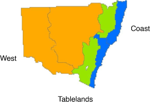
In order to look at the extent of koala roadkill at a regional scale, records were assigned to one of three geographic regions derived from the seven koala management areas (KMAs) (DECC 2008) (Fig. 2). The coastal region consisted of KMA1 (North Coast), KMA2 (Central Coast) and KMA3 (South Coast). The tablelands region consisted of KMA4 (Northern Tablelands) and KMA5 (Central and Southern Tablelands). The western (inland) region consisted of KMA6 (Western Slopes and Plains) and KMA7 (Far West and South West).
|
We used a logistic regression to test for patterns of how road type and location may influence the likelihood of a koala dying on the road. The model included koalas observed as being either alive or dead on road as the dependent binary variable. Two categorical explanatory variables were included: road type and geographic location. A full model was run including interaction between the two explanatory variables using the LOGISTIC procedure in SAS software (SAS Version 9.4, SAS Inc, Cary USA).
Coffs Harbour LGA
In addition to the Atlas of NSW Wildlife data used across the state, the analysis of koala roadkill at the scale of local government area (Coffs Harbour LGA) included data from a major community survey completed in 1990 that formed part of the preparation of a Comprehensive Koala Plan of Management for Coffs Harbour City Council (Lunney et al. 1999, 2000). The survey asked participants where they had seen koalas and if the koala was dead on the road. Using the same three road types as for the state-wide comparison, the number of koala records within 100 m of the road centreline within the Coffs Harbour LGA was determined.
Coffs Harbour LGA also provided the opportunity to look at the relationship of koala roadkill to koala habitat, a variable not available at the state scale. As part of the Comprehensive Koala Plan of Management, a map of koala habitat was prepared ranking koala habitat quality as primary, secondary and tertiary based on a combination of vegetation type, geology and koala vegetation use. Using ArcGIS (version 10.1), each koala record within 100 m of a road centreline was assigned to a koala habitat category (‘habitat type’) based on either the habitat polygon that it sat within or else the nearest koala habitat polygon based on a straight-line distance to the polygon edge. We were able to categorise each koala record, including the roadkill, based on the road type and the koala habitat type.
We used a logistic regression to test for patterns of how road type and koala habitat type may influence the likelihood of a koala dying on the road. The model included koalas observed as either alive or dead as the dependent binary variable and two categorical explanatory variables: road type and koala habitat type. A full model was run including interaction between the two explanatory variables using the LOGISTIC procedure in SAS software (SAS Version 9.4, SAS Inc, Cary USA).
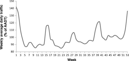
At a local scale, the characteristics of traffic flow can influence, and possibly explain, koala road deaths. One characteristic of traffic that will influence the rate of roadkill is the number of vehicles on the road and, in particular, the number of vehicles passing a particular location (Rhodes et al. 2014). To determine the characteristics of traffic that may affect koalas within Coffs Harbour LGA, we looked at the average time between vehicles passing a set point on the Pacific Highway and the monthly Annual Average Daily Traffic counts (AADT). Data were based on a 2007 AADT count of 21 537 vehicles on the Pacific Highway at a station south of Sawtell Road (data provided by Roads and Maritime Services (RMS) Northern Region) and the hourly breakdown of vehicles from the Woolgoolga to Ballina Pacific Highway Upgrade Environmental Impact Statement (RMS 2012). We further looked at the weekly average daily traffic volume as a percentage of AADT based on traffic counts presented in RMS (2012).
Results
State-wide
Across NSW, 12 970 koala records (1970–2014) occur within 100 m of the centreline of a road. Of these records, 542 (4%) were recorded as being dead on a road (Table 1). While somewhat similar numbers of koalas were recorded as dead on road across the three road type categories, there is a major difference in the percentage of koalas recorded as dead compared with koalas seen within 100 m of a road across the three road type categories. Over a quarter of all koalas observed on or adjacent to primary roads were dead on the road, compared to only 6% on arterial roads and 2% on local roads (Table 1). The overall logistic regression model was significant (likelihood ratio chi-squared = 501.5, d.f. 8, P < 0.0001). There was a significant difference in the likelihood of a koala being dead related to road type (χ2 = 430.16, d.f. = 2, P < 0.0001), no significant difference related to geographic region (χ2 = 2.31, d.f. = 2, P > 0.05) and a significant interaction between road type and geographic region (χ2 = 15.00, d.f. = 4, P = 0.005). Comparing the maximum likelihood estimates among the three road types showed that the levels of koala death were all significantly different from the overall average and contributed to the overall model: local (MLE = −2.82, χ2 = 423.53, P < 0.0001); arterial (MLE = −1.60, χ2 = 143.46, P < 0.0001); primary (MLE = 4.42, χ2 = 318.27, P < 0.0001). Although an individual koala is more likely to die if adjacent to a primary road than the other two road types, the vastly different total length of roads across the state in the three categories (local roads 122 755 km; arterial roads 79 706 km; primary roads 12 972 km) accounts for the similarity in the actual number of koalas seen dead in the three categories, despite the differences in the percentage dead on road. Also, a pronounced result from the regional analyses is that koala records are predominantly coastal, and so are the koala roadkill records.

|
The regional percentage of koalas dead on road shows little variation from a pattern of the highest mortality being adjacent to primary roads (Table 1). Analysis of the Maximum Likelihood Estimates for the nine interaction combinations showed that only the interaction of local roads in the west was significant (MLE = 1.01, χ2 = 8.20, P < 0.005). The remaining eight interaction terms did not contribute to the overall model.
Coffs Harbour LGA
There was a total of 2885 koala records from within the Coffs Harbour LGA within 100 m of a road (Table 2). Of these records, 477 (17%) were recorded as being dead on the road. Although the road mortality here is higher than the average for the state, the pattern shown at the LGA scale is similar to that seen across the state of NSW: a koala has a higher likelihood of being killed on a primary road, followed by an arterial road, and the lowest likelihood of being killed is on a local road (Table 2). However, the high number of koalas observed next to local roads means that the actual number recorded dead is higher than on primary or arterial roads due to the much greater length of local roads (Table 2). Habitat type adjacent to a road appears to have little influence on the likelihood of a koala being killed on the road (Table 2).

|
Overall the logistic regression model was significant (Likelihood ratio χ2 = 274.01, d.f. = 8, P < 0.0001). Road type was a significant contributor to the model (joint test χ2 = 189.58, d.f. = 2, P < 0.0001), whereas koala habitat type (joint test χ2 = 3.36, d.f. = 2, P > 0.05) and the interaction of road type and koala habitat type (joint test χ2 = 8.81, d.f. = 4, P > 0.05) were both not significant. Analysis of the maximum likelihood estimates showed that all three road types made significant contributions to the model: local (MLE = −1.90, χ2 = 161.08, P < 0.0001); arterial (MLE = −0.46, χ2 = 7.95, P < 0.005); primary (MLE = 4.42, χ2 = 72.42, P < 0.0001).
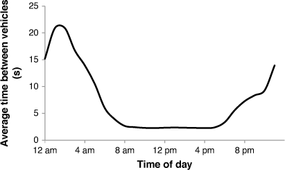
The traffic count data illuminate the problem for a koala attempting to cross a primary road. Gaps between vehicles on the Pacific Highway, when wildlife may be able to cross without being hit, average between 2 and 22 seconds (Fig. 3). However, road traffic tends to clump into ‘platoons’, rather than flow evenly, so that the period from about 10 pm to 5 am likely contains some extended gaps, enabling a safer crossing for any animals able to utilise them. Throughout the year traffic densities fluctuate with school holidays and season (Fig. 4), with a major peak in the middle of the period (September/October) when koalas are most mobile.
|
|
Discussion
We examined koala roadkill at two scales: the state-wide picture (also three NSW divisions of coast, tablelands and inland), and an LGA where we also included habitat type at three levels (primary, secondary and tertiary). At each scale koala roadkill was examined by road type, with three levels (primary, arterial and local). Scale has implications for koala threat management because knowing whether problems are widespread or localised can determine not only how the problems may be addressed, but also where responsibility lies for policy, funding and threat mitigation. This study has provided the first distinct picture of where koala roadkill occurs across NSW.
From our assessment, a number of points become clear. Wherever koala populations and roads occur together there is roadkill. Where more koalas occur in the landscape, there is more roadkill. This is seen spatially with higher numbers of koalas dead on road in the north coast of NSW, a geographic region recognised as having high numbers of koalas, and at the smaller spatial scale of Coffs Harbour LGA, where higher numbers of dead on road are seen in primary koala habitat, which supports higher numbers of koalas, although we note that we found no significant difference in the proportion of the koala population adjacent to primary, secondary or tertiary habitat being killed on the road.
Analysis of the probability of a koala being killed shows that road type is important, with primary roads having the highest likelihood of koalas dying. This is seen at the two spatial scales investigated, and in each of the three regions. This is likely due to the greater width of the primary roads and increased volume and speed of the traffic, and, as shown in Coffs Harbour LGA (Fig. 3), the time available for fauna to effect a safe crossing of a busy primary road is measured in seconds.
Primary roads provide a good opportunity for mitigation. They are managed by the one State government department in NSW (RMS) and mitigation measures, such as gap-free fauna fencing, are generally more accepted along such roads because of the level of disturbance already made by the road. It would be far harder to fence arterial or local roads and the value of this would be questionable given the lower rate of koala deaths per kilometre, the need to balance benefits against cost, and the overall barrier effect that fences produce. As an example, Goldingay and Dobner (2014) address the limitations for mitigation at the local scale in an urban area. Similarly, for arterial roads, where local government is required to pay the costs, more gaps for residences decrease the value of fences because koalas walk through the gaps (Lunney et al. 2022).
Mitigating the impacts of roads on koalas
There is a need to correctly assess the relative importance of koala roadkill compared with other factors. Roadkill is visually confronting, but predation, particularly from dogs, is rarely witnessed. In our radio-tracking study of a large population of koalas after a wildfire at Port Stephens, a coastal LGA between Sydney and Coffs Harbour, no koalas were killed by cars, despite being adjacent to arterial roads, with the surprise finding that dogs were the primary killer (Lunney et al. 2007). The radio-tracking revealed that koalas that were killed by dogs were hidden under bushes behind locked gates on mining and water catchment land. The resulting action was to manage predatory dogs in the post-fire landscape, as well as manage traffic on the surrounding roads, where dead koalas were conspicuous and a big road notice showed the incremental koala road toll. Similarly, a detailed population study in south-east Queensland found that, apart from natural mortality, disease was the biggest killer, with roads being the second biggest (Rhodes et al. 2011). A key point here is that, without a detailed population study, an easy default assumption is that roadkill takes a greater proportion, compared with other threats, of the koala population than is actually the case if the other threats are hidden. This points to the need for population studies that consider all threats, not only studies of roadkill. Somewhat pessimistically, Preece (2007), who modelled threats to koalas in SE Queensland, concluded that urban koala populations will not be able to withstand the high rates of anthropogenic mortality, such as roadkill, in addition to natural mortality with the result being localised extinctions.
The matter of long-term impacts has received considered attention from a number of angles. Eberhardt et al. (2013) pointed out that road mortality hotspots are typically located where wildlife habitats are near to, or straddle, the road. They identify such locations as the most appropriate sites for mitigation where the populations have not already been reduced by road mortality. Polak et al. (2014) examined the vulnerable koala population living in habitat patches separated by roads on the Koala Coast in south-east Queensland, and applied decision science to find the best solutions for a range of possible costs of mitigation. They mathematically formulated the problem of prioritising different road mitigation actions, and in all of the model runs (no action at all, and fences with or without crossings, on different road segments) the ‘Do Nothing’ approach of no mitigation on any road segment was the worst for population numbers. To the authors’ surprise, full mitigation (Fence + Wildlife crossing, i.e. the most costly solution) on all road segments did not maximise mean population numbers. Their analysis also showed that achieving very good outcomes for koalas will be expensive, and that reducing investment will result in a much smaller koala population.
For koalas, this is a pertinent issue because the koala has been recognised as a threatened species under NSW legislation since 1992, with roadkill being recognised as a factor in its decline. The Senate committee (Commonwealth of Australia 2011) also recommended that where the Australian Government provides funding for roads or other infrastructure in or adjacent to koala habitat, it be contingent on the provision of adequate koala protections. Another recommendation was that the Australian Government work with the states to develop new national guidelines to ensure that all new roads and upgrades in or adjacent to koala habitat are koala-friendly. We urge that research both precede, and follow up, implementing such expensive measures to combat koala roadkill. Goldingay et al. (2018) found that no koalas were detected in the escape ramps on the Oxley Highway, which had been installed for koalas, and that only nine were detected in the underpasses.
If ever we are to minimise the impacts of roads, particularly highways, on koalas, then we need to respond to the practical requirements of transport agencies, which in NSW is the Roads and Maritime Services (RMS). The consultation by RMS with one of us (CM) over the Bonville deviation near Coffs Harbour was very responsive to environmental factors which arose during initial planning. Ecologists are now being engaged from the early stages of route selection by RMS. We need to avoid the danger that ecologists do not understand road development processes as much as the other way around. Jones et al. (2015, p. 395) expand this point diplomatically when they state that experience from committees world-wide on road design and the public has identified some common themes, with the most important being the extent to which one side is ignorant of the key concepts of the other. We also have formed the view that roadkill needs to be considered much earlier in the planning process, with Rhodes et al. (2014) providing a numerically worked example, also from coastal NSW. Finally, we need to define the issues more sharply, which is part of the point of this paper, and we need to overcome what is a blind spot in public perception of the issue (Lunney 2013).
Is it too late or too difficult to prevent koala roadkill?
The recognition of the value and importance of managing wildlife, especially threatened species and natural habitats, has mostly occurred since the mid-20th century, and New South Wales is typical (Lunney et al. 2017). By the time any environmental legislation was in place, NSW was criss-crossed with roads and filled with high speed motor vehicles, but there were very few provisions for understanding or managing wildlife roadkill. As is now all too apparent, the speed of economic growth and population increase has far exceeded our capacity to contain the environmental damage that follows in their wake. The focus on mitigating wildlife roadkill presents a clear-cut case that the conservation of the native fauna is an afterthought. The question then is ‘have we left it too late to prevent further roadkill?’.
Some clear recommendations can be made from this study. Specifically, our results indicate that different road types should be treated differently as they affect koala mortality in different ways. Highways are likely to be a good option for targeted mitigation measures as they are likely to provide the biggest benefit per dollar spent. Local and arterial roads, on the other hand, are a more problematic, ubiquitous issue where targeted retrofitting may be less effective overall due to the diffuse nature of the threat. Here education and regulation might be more effective.
We have two primary tools to approach mitigating the adverse impact of roads on native fauna and natural habitats – education, and research in an adaptive management framework, not only of physical structures, such as fences, but policy adjustments such as valuing daylight saving so that peak periods of traffic occur before dark (Ellis et al. 2016).
The case for education is compelling, and it will include relying on a broad-based understanding of, and insights into, issues that go well beyond the normal scope of the work of ecologists and engineers (Stratford et al. 2000; Lunney 2013). Recent studies have shown the potential of crowdsourced geographic citizen science to contribute to biodiversity research on koalas (Predavec et al. 2016; Brown et al. 2018, 2019a, 2019b), to the extent that local, State and Commonwealth governments can gain a better view of the conservation issues and management options for koalas that cross roads. This includes a sense of the willingness of citizens to exercise restraint in activities that endanger koalas and to support government initiatives to manage the issues.
In asking, what is policy-oriented environmental research worth, Pannell et al. (2018) recognise that environmental and conservation scientists are increasingly being asked to justify their work in terms of benefits. Koalas are no exception. The authors conclude that improved measurement of benefits from environmental research would assist environmental scientists. We add that while the cost of research is evident in any policy or management business case, the cost of not conducting research on roadkill and the broader issue of the long-term survival of the local koala populations remains uncosted. We include monitoring as being within the framework of research, because without a rigorous design, and one that draws on the rapidly changing international network of researchers in this subject, we shall never know whether a reduction in roadkill numbers is a measure of the success of a mitigation action or whether, more simply, there are fewer and fewer koalas. To that end, NSW has now adopted a koala monitoring framework (DPIE 2021).
The conclusion can be drawn that roadkill is an ever-present threat to koalas across their entire range in NSW. We can expect that the use of vehicles will steadily rise with the increasing human population size, and that koala habitat will continue to be lost, or fragmented, with more and more developments and thus more roads and road upgrades. The consequence is that koala roadkill will remove an ever-increasing proportion of what is recognised as a decreasing koala population in NSW (Adams-Hosking et al. 2016). Roads are fixtures on the landscape, and there is as yet little public perception of how to understand and tackle this vexatious matter of unwanted animal death (Lunney 2013). Our work provides a framework for planners, government decision-makers and other managers to take action on the issue of koala road death in their locality at a scale appropriate to the scale of the problem, and with an understanding of why koala black spots are where they are. Our answer to the terrible question, ‘is it too difficult to prevent further roadkill?’ is yes, it is too difficult to prevent roadkill, but it is not too difficult to mitigate roadkill, and we now have a better grasp of where to target those efforts.
Data availability
The data that support this study are available in NSW BioNet | NSW Environment, Energy and Science, except for 1990 data from Coffs Harbour, collected before Bionet was created, which is displayed in the Coffs Harbour Comprehensive Koala Plan of Management (Lunney et al. 1999).
Conflicts of interest
The authors declare no conflicts of interest.
Declaration of funding
This research did not receive any specific funding.
Acknowledgements
We wish to thank our DPE Coffs Harbour colleagues, John Turbill and Martin Smith, for their insights into the local issues with koala management, including roadkill. We also wish to thank RMS staff, and Scott Lawrence in particular, for data on roads and traffic, and for a field day in July 2014 in Coffs Harbour. We are also indebted to Rodney van der Ree and other organising members of ANET for a most timely conference (July 2014) at a most fortuitous location (Coffs Harbour). We also thank the editor, Ross Goldingay, for his helpful comments.
References
Adams-Hosking, C., McBride, M., Baxter, G., Burgman, M., de Villiers, D., Kavanagh, R., Lawler, I., Lunney, D., Melzer, A., Menkhorst, P., Molsher, R., Moore, B. D., Phalen, D., Rhodes, J. R., Todd, C., Whisson, D., and McAlpine, C. (2016). Use of expert knowledge to elicit population trends for the koala. Diversity and Distributions 22, 249–262.| Use of expert knowledge to elicit population trends for the koala.Crossref | GoogleScholarGoogle Scholar |
Ascensão, F., Kindel, A., Teixeira, F. Z., Barrientos, R., D’Amico, M., Borda-de-Água, L., and Pereira, H. M. (2019). Beware that the lack of wildlife mortality records can mask a serious impact of linear infrastructures. Global Ecology and Conservation 19, e00661.
| Beware that the lack of wildlife mortality records can mask a serious impact of linear infrastructures.Crossref | GoogleScholarGoogle Scholar |
Beckmann, J. P., Clevenger, A. P., Huijser, M. P., and Hilty, J. A. (Eds) (2010). ‘Safe passages: highways, wildlife, and habitat connectivity’. (Island Press: Washington DC, USA.)
Bond, A. R. F., and Jones, D. N. (2013). Roads and macropods: interactions and implications. Australian Mammalogy 36, 1–14.
| Roads and macropods: interactions and implications.Crossref | GoogleScholarGoogle Scholar |
Brown, G., McAlpine, C., Rhodes, J., Lunney, D., Goldingay, R., Fielding, K., Hetherington, S., Hopkins, M., Manning, C., Wood, M., Brace, A., and Vass, L. (2018). Assessing the validity of crowdsourced wildlife observations for conservation using public participatory mapping methods. Biological Conservation 227, 141–151.
| Assessing the validity of crowdsourced wildlife observations for conservation using public participatory mapping methods.Crossref | GoogleScholarGoogle Scholar |
Brown, G., Rhodes, J., Lunney, D., Goldingay, R., Fielding, K., Garofano, N., Hetherington, S., Hopkins, M., Green, J., McNamara, S., Brace, A., Vass, L., Swankie, L., and McAlpine, C. (2019a). The influence of sampling design on spatial data quality in a geographic citizen science project. Transactions in GIS. 2019, 1–20.
| The influence of sampling design on spatial data quality in a geographic citizen science project.Crossref | GoogleScholarGoogle Scholar |
Brown, G., McAlpine, C., Rhodes, J., Lunney, D., Goldingay, R., Fielding, K., Hetherington, S., Hopkins, M., Manning, C., Wood, M., Brace, A., Vass, L., and Swankie, L. (2019b). Integration of social spatial data to assess conservation opportunities and priorities. Biological Conservation 236, 452–463.
| Integration of social spatial data to assess conservation opportunities and priorities.Crossref | GoogleScholarGoogle Scholar |
Charalambous, R., and Narayan, E. (2020). A 29-year retrospective analysis of koala rescues in New South Wales, Australia. Plos One 15, e0239182.
| A 29-year retrospective analysis of koala rescues in New South Wales, Australia.Crossref | GoogleScholarGoogle Scholar | 33112860PubMed |
Collinson, W. J., Marneweck, C., and Davies-Mostert, H. T. (2019). Protecting the protected: reducing wildlife roadkill in protected areas. Animal Conservation 22, 396–403.
| Protecting the protected: reducing wildlife roadkill in protected areas.Crossref | GoogleScholarGoogle Scholar |
Commonwealth of Australia (2009). National Koala conservation and management strategy 2009–2014. Department of the Environment, Water, Heritage and the Arts, Canberra.
Commonwealth of Australia (2011). The koala – saving our national icon. Senate Environment and Communications References Committee. Senate Printing Unit, Parliament House, Canberra, ACT Australia.
DAWE (2021a). Consultation on species listing eligibility and conservation actions Phascolarctos cinereus (Koala). Department of Agriculture, Water and the Environment. Available at https://www.environment.gov.au/biodiversity/threatened/nominations/comment [Accessed 20 July 2021]
DAWE (2021b). National recovery plan for the Koala: Phascolarctos cinereus (combined populations of Queensland, New South Wales and the Australian Capital Territory), Draft June 2021. Department of Agriculture, Water and the Environment, Canberra, ACT 2601.
DECC (2008). NSW recovery plan for the Koala (Phascolarctos cinereus). Department of Environment and Climate Change, Sydney, NSW. (The department is now the NSW Dept. of Planning, Industry and Environment).
Dexter, C. E., Appleby, R. G., Scott, J., Edgar, J. P., and Jones, D. N. (2018). Individuals matter: predicting koala road crossing behaviour in south-east Queensland. Australian Mammalogy 40, 67–75.
| Individuals matter: predicting koala road crossing behaviour in south-east Queensland.Crossref | GoogleScholarGoogle Scholar |
Dique, D. S., Thompson, J., Preece, H. J., Penfold, G. C., de Villiers, D. L., and Leslie, R. S. (2003). Koala mortality on roads in south-east Queensland: the koala speed trial zone. Wildlife Research 30, 419–426.
| Koala mortality on roads in south-east Queensland: the koala speed trial zone.Crossref | GoogleScholarGoogle Scholar |
Dopp, K. (2017) Reducing wildlife-vehicle collisions & preserving local climate/economy. Available at https://ssrn.com/abstract=2827176
DPIE (2020a). Wildlife vehicle strike and contributing factors. Koala vehicle strike fact sheet 1. Published by: Environment, Energy and Science, Department of Planning, Industry and Environment, Locked Bag 5022, Parramatta NSW 2124.
DPIE (2020b). How to keep koalas off the road. Koala vehicle strike fact sheet 2. Published by: Environment, Energy and Science, Department of Planning, Industry and Environment, Locked Bag 5022, Parramatta NSW 2124.
DPIE (2020c). How to change driver behaviour. Koala vehicle strike fact sheet 3. Published by: Environment, Energy and Science, Department of Planning, Industry and Environment, Locked Bag 5022, Parramatta NSW 2124.
DPIE (2021). NSW Koala monitoring framework. Available at https://www.environment.nsw.gov.au/-/media/OEH/Corporate-Site/Documents/Animals-and-plants/Threatened-species/nsw-koala-monitoring-framework-210261.pdf [Accessed 24 January 2021]
Eberhardt, E., Mitchell, S., and Fahrig, L. (2013). Road kill hotspots do not effectively indicate mitigation locations when past road kill has depressed populations. Journal of Wildlife Management 77, 1353–1359.
| Road kill hotspots do not effectively indicate mitigation locations when past road kill has depressed populations.Crossref | GoogleScholarGoogle Scholar |
EES (2019). NSW Koala strategy 2018–19 annual report. Department of Environment, Energy and Science (in Department of Planning, Industry and Environment) on behalf of the NSW government, Goulburn St., Sydney NSW 2000.
Ellis, W. A., FitzGibbon, S. I., Barth, B. J., Niehaus, A. C., David, G. K., Taylor, B. D., Matsushige, H., Melzer, A., Bercovitch, F. B., Carrick, F., Jones, D. N., Dexter, C., Gillett, A., Predavec, M., Lunney, D., and Wilson, R. S. (2016). Daylight saving time can decrease the frequency of wildlife – vehicle collisions. Biology Letters 12, 20160632.
| Daylight saving time can decrease the frequency of wildlife – vehicle collisions.Crossref | GoogleScholarGoogle Scholar | 27881767PubMed |
Fahrig, L., and Rytwinski, T. (2009). Effects of roads on animal abundance: an empirical review and synthesis. Ecology and Society 14, 21.
| Effects of roads on animal abundance: an empirical review and synthesis.Crossref | GoogleScholarGoogle Scholar |
Forman, R. T. T. (2010). Foreword. In ‘Safe passages: highways, wildlife, and habitat connectivity’. (Eds J. P. Beckmann, A. P. Clevenger, M. P. Huijser, J. A. Hilty), pp. xi–xiii. (Island Press: Washington DC, USA.)
Forman, R. T. T., Sperling, D., Bissonette, J. A., Clevenger, A. P., Cutshall, C. D., Dale, V. H., Fahrig, L., France, R., Goldman, C. R., Heanue, K., Jones, J. A., Swanson, F. J., Turrentine, T., and Winter, T. C. (2003). ‘Road ecology: science and solutions’. (Island Press: Washington DC, USA.)
Fox, S., Potts, J., Pemberton, D., and Crosswell, D. (2019). Roadkill mitigation: trialing virtual fence devices on the west coast of Tasmania. Australian Mammalogy 41, 205–211.
| Roadkill mitigation: trialing virtual fence devices on the west coast of Tasmania.Crossref | GoogleScholarGoogle Scholar |
Goldingay, R. L., and Dobner, B. (2014). Home range areas of koalas in an urban area of north-east New South Wales. Australian Mammalogy 36, 74–80.
| Home range areas of koalas in an urban area of north-east New South Wales.Crossref | GoogleScholarGoogle Scholar |
Goldingay, R. L., Taylor, B. D., Parkyn, J. L., and Lindsay, J. M. (2018). Are wildlife escape ramps needed along Australian highways? Ecological Restoration and Management 19, 198–203.
| Are wildlife escape ramps needed along Australian highways?Crossref | GoogleScholarGoogle Scholar |
Gonzalez-Astudillo, V., Allavena, R., McKinnon, A., Larkin, R., and Henning, J. (2017). Decline causes of koalas in South East Queensland, Australia: a 17-year retrospective study of mortality and morbidity. Scientific Reports 7, 42587.
| Decline causes of koalas in South East Queensland, Australia: a 17-year retrospective study of mortality and morbidity.Crossref | GoogleScholarGoogle Scholar | 28218272PubMed |
Grueber, C. E., Reid-Wainscoat, E. E., Fox, S., Belov, K., Shier, D. M., Hogg, C. J., and Pemberton, D. (2018). Increasing generations in captivity is associated with increased vulnerability of Tasmanian devils to vehicle strike following release to the wild. Scientific Reports 7, 2161.
| Increasing generations in captivity is associated with increased vulnerability of Tasmanian devils to vehicle strike following release to the wild.Crossref | GoogleScholarGoogle Scholar |
Harris, C., Marlow, J., and Harris, A. (2008). No prescription yet to counter the roadkill of our native fauna: a study of roadkill in the Narrabeen Catchment of Sydney. In ‘Too close for comfort: contentious issues in human-wildlife encounters’. (Eds D. Lunney, A. Munn, W. Meikle) pp. 96–102. (Royal Zoological Society of New South Wales: Mosman.)
Hobday, A., and Minstrell, M. (2008). Distribution and abundance of roadkill on Tasmanian highways: human management options. Wildlife Research 35, 712–726.
| Distribution and abundance of roadkill on Tasmanian highways: human management options.Crossref | GoogleScholarGoogle Scholar |
Jones, D. (2012). Fauna overpasses increase habitat connectivity and road permeability. Australasian Wildlife Management Newsletter 26, 5–8.
Jones, D., Bakker, M., Bichet, O., Coutts, R., and Wearing, T. (2011). Restoring habitat connectivity over the road: vegetation on a fauna land-bridge in south-east Queensland. Ecological Management and Restoration 12, 76–79.
| Restoring habitat connectivity over the road: vegetation on a fauna land-bridge in south-east Queensland.Crossref | GoogleScholarGoogle Scholar |
Jones, D. N., Griffiths, M. R., Griffiths, J. R., Hacker, J. L. F., and Hacker, J. B. (2014). Implications of upgrading a minor forest road on traffic and road-kill in southeast Queensland. Australasian Journal of Environmental Management 21, 429–440.
| Implications of upgrading a minor forest road on traffic and road-kill in southeast Queensland.Crossref | GoogleScholarGoogle Scholar |
Jones, D., Bekker, H., and van der Ree, R. (2015). Road ecology in an urbanising world. In ‘Handbook of road ecology’. (Eds R. van der Ree, D. J. Smith, C. Grilo) pp. 391–396. (John Wiley and Sons: West Sussex, UK.)
Kreling, S. E. S., Gaynor, K. M., and Coon, C. A. C. (2019). Roadkill distribution at the wildland–urban interface. Journal of Wildlife Management 83, 1427–1436.
| Roadkill distribution at the wildland–urban interface.Crossref | GoogleScholarGoogle Scholar |
Laurance, W. F., Clements, G. R., Sloan, S., O’Connell, C. S., Mueller, N. D., Goosem, M., Venter, O., Edwards, D. P., Phalan, B., Balmford, A., van der Ree, R., and Arrea, I. B. (2014). A global strategy for road building. Nature 513, 229–232.
| A global strategy for road building.Crossref | GoogleScholarGoogle Scholar | 25162528PubMed |
Lunney, D. (2013). Wildlife roadkill: overcoming a blind spot in public perception. Pacific Conservation Biology 19, 233–249.
| Wildlife roadkill: overcoming a blind spot in public perception.Crossref | GoogleScholarGoogle Scholar |
Lunney, D., Moon, C., Matthews, A., and Turbill, J. (1999). Coffs Harbour city Koala plan of management. Parts A & B. NSW National Parks and Wildlife Service, Hurstville.
Lunney, D., Matthews, A., Moon, C., and Ferrier, S. (2000). Incorporating habitat mapping into practical koala conservation on private lands. Conservation Biology 14, 669–680.
| Incorporating habitat mapping into practical koala conservation on private lands.Crossref | GoogleScholarGoogle Scholar |
Lunney, D., Gresser, S., O’Neill, L. E., Matthews, A., and Rhodes, J. (2007). The impact of fire and dogs on koalas at Port Stephens, New South Wales, using population viability analysis. Pacific Conservation Biology 13, 189–201.
| The impact of fire and dogs on koalas at Port Stephens, New South Wales, using population viability analysis.Crossref | GoogleScholarGoogle Scholar |
Lunney, D., Crowther, M. S., Shannon, I., and Bryant, J. V. (2009). Combining a map-based public survey with an estimation of site occupancy to determine the recent and changing distribution of the koala in New South Wales. Wildlife Research 36, 262–273.
| Combining a map-based public survey with an estimation of site occupancy to determine the recent and changing distribution of the koala in New South Wales.Crossref | GoogleScholarGoogle Scholar |
Lunney, D., Close, R., Crowther, M. S., Bryant, J., Shannon, I., Madden, K., and Ward, S. (2010) The koalas of Campbelltown, south-western Sydney: does their natural history foretell of an unnatural future? In ‘The natural history of Sydney’. (Eds D. Lunney, P. Hutchings, D. Hochuli) pp. 339–370. (Royal Zoological Society of New South Wales: Mosman, NSW.)
Lunney, D., Hope, B., and Shannon, I. (2017). Protect our protected areas!: the value of protected areas for fauna research and conservation, a case study of New South Wales. Australian Zoologist 32, 296–344.
| Protect our protected areas!: the value of protected areas for fauna research and conservation, a case study of New South Wales.Crossref | GoogleScholarGoogle Scholar |
Lunney, D., Moon, C., Sonawarne, I., Predavec, M., and Rhodes, J. R. (2022). A 6-year study of mitigating koala roadkill during an upgrade of the Pacific Highway at Lindsay’s cutting, Coffs Harbour New South Wales. Australian Mammalogy , .
| A 6-year study of mitigating koala roadkill during an upgrade of the Pacific Highway at Lindsay’s cutting, Coffs Harbour New South Wales.Crossref | GoogleScholarGoogle Scholar |
Malo, J. E., Suarez, F., and Diez, A. (2004). Can we mitigate animal: vehicle accidents using predictive models? Journal of Applied Ecology 41, 701–710.
| Can we mitigate animal: vehicle accidents using predictive models?Crossref | GoogleScholarGoogle Scholar |
McAlpine, C. A., Lunney, D., Melzer, A., Menkhorst, P., Phillips, S., Phalen, D., Ellis, W., Foley, W., Baxter, G., de Villiers, D., Kavanagh, R., Adams-Hosking, C., Todd, C., Whisson, D., Molsher, R., Walter, M., Lawler, I., and Close, R. (2015). Conserving koalas: a review of the contrasting regional trends, outlooks and policy challenges. Biological Conservation 192, 226–236.
| Conserving koalas: a review of the contrasting regional trends, outlooks and policy challenges.Crossref | GoogleScholarGoogle Scholar |
McCall, S., McCarthy, M., van der Ree, R., Harper, M., Cesarini, S., and Soanes, K. (2010). Evidence that a highway reduces apparent survival rates of squirrel gliders. Ecology and Society 15, 27–44.
| Evidence that a highway reduces apparent survival rates of squirrel gliders.Crossref | GoogleScholarGoogle Scholar |
OEH (2018). NSW Koala strategy. Office of Environment and Heritage NSW, Sydney South NSW 2000.
Pannell, D. J, Alston, J. M., Jeffrey, S., Buckley, Y. M., Vesk, P., Rhodes, J. R., McDonald-Madden, E., Nally, S., Goucher, G., and Thamo, T. (2018). Policy-oriented environmental research: What is it worth? Environmental Science and Policy 86, 64–71.
| Policy-oriented environmental research: What is it worth?Crossref | GoogleScholarGoogle Scholar |
Parliament of N.S.W (2020). Koala populations and habitat in New South Wales. Portfolio committee no. 7 – planning and environment, report no. 3, Sydney, NSW.
Polak, T., Rhodes, J. R., Jones, D., and Possingham, H. P. (2014). Optimal planning for mitigating the impacts of roads on wildlife. Journal of Applied Ecology 51, 726–734.
| Optimal planning for mitigating the impacts of roads on wildlife.Crossref | GoogleScholarGoogle Scholar |
Predavec, M., Lunney, D., Hope, B., Stalenberg, E., Shannon, I., Crowther, M.S., and Miller, I. (2016). The contribution of community wisdom to conservation ecology. Conservation Biology 30, 496–505.
| The contribution of community wisdom to conservation ecology.Crossref | GoogleScholarGoogle Scholar | 27110657PubMed |
Preece, H. J. (2007). Monitoring and modelling threats to koala populations in rapidly urbanising landscapes: Koala coast, south east Queensland, Australia. PhD thesis, University of Queensland, Australia.
Rajvanshi, A., Mathur, V. B., Teleki, G. C., and Mukherjee, S. K. (2001). ‘Roads, sensitive habitats and wildlife: environmental guideline for India and South Asia’. (Wildlife Institute of India, Dehradun and Canadian Environmental Collaborative Ltd: Toronto, Canada.)
Ramp, D., and Roger, E. (2008). Frequency of animal-vehicle collisions in NSW. In ‘Too close for comfort: contentious issues in human-wildlife encounters’. (Eds D. Lunney, A. Munn, W. Meikle) pp. 118–126. (Royal Zoological Society of New South Wales: Mosman.)
Rhodes, J. R., Ng, C. F., de Villiers, D. L., Preece, H. J., McAlpine, C. A., and Possingham, H. P. (2011). Using integrated population modelling to quantify the implications of multiple threatening processes for a rapidly declining population. Biological Conservation 144, 1081–1088.
| Using integrated population modelling to quantify the implications of multiple threatening processes for a rapidly declining population.Crossref | GoogleScholarGoogle Scholar |
Rhodes, J. R., Lunney, D., Callaghan, J., and McAlpine, D. (2014). A few large roads or many small ones? How to accommodate growth in vehicle numbers to minimise impacts on wildlife. Plos One 9, e91093.
| A few large roads or many small ones? How to accommodate growth in vehicle numbers to minimise impacts on wildlife.Crossref | GoogleScholarGoogle Scholar | 24646891PubMed |
RMS (2012). Woolgoolga to Ballina upgrading the pacific highway. NSW roads and maritime service. Available at https://pacifichighway.nsw.gov.au/sites/default/files/media/documents/2018/Woolgoolga%20to%20Ballina%20upgrade%20Environmental%20Impact%20Statement%20Main%20Volume%201%20-%201.%20Introduction.pdf [Accessed 1 February 2018]
Roger, E., Laffan, S., and Ramp, D. (2011). Road impacts a tipping point for wildlife populations in threatened landscapes. Population Ecology 53, 215–227.
| Road impacts a tipping point for wildlife populations in threatened landscapes.Crossref | GoogleScholarGoogle Scholar |
Roger, E., Bino, G., and Ramp, D. (2012). Linking habitat suitability and road mortalities across geographic ranges. Landscape Ecology 27, 1167–1181.
| Linking habitat suitability and road mortalities across geographic ranges.Crossref | GoogleScholarGoogle Scholar |
Santori, C., Spencer, R-J., Van Dyke, J. U., and Thompson, M. B. (2018). Road mortality of the eastern long-necked turtle (Chelodina longicollis) along the Murray River, Australia: an assessment using citizen science. Australian Journal of Zoology 66, 41–49.
| Road mortality of the eastern long-necked turtle (Chelodina longicollis) along the Murray River, Australia: an assessment using citizen science.Crossref | GoogleScholarGoogle Scholar |
Schlagloth, R., Santamaria, F., Melzer, A., Keatley, M. R., and Houston, W. (2021). Vehicle collisions and dog attacks on Victorian koalas as evidenced by a retrospective analysis of sightings and admission records 1997–2011. Australian Zoologist , .
| Vehicle collisions and dog attacks on Victorian koalas as evidenced by a retrospective analysis of sightings and admission records 1997–2011.Crossref | GoogleScholarGoogle Scholar |
Sherwood, B., Cutler, D., and Burton, J. A. (Eds) (2002). ‘Wildlife and roads: the ecological impact’. (Imperial College Press: London, UK.)
Shumway, N., Lunney, D., Seabrook, L., and McAlpine, C. (2015). Saving our national icon: an ecological analysis of the 2011 Australian Senate inquiry into status of the koala. Environmental Science & Policy 54, 297–303.
| Saving our national icon: an ecological analysis of the 2011 Australian Senate inquiry into status of the koala.Crossref | GoogleScholarGoogle Scholar |
Soanes, K., Mitchell, B., and van der Ree, R. (2017). Quantifying predation attempts on arboreal marsupials using wildlife crossing structures above a major road. Australian Mammalogy 39, 254–257.
| Quantifying predation attempts on arboreal marsupials using wildlife crossing structures above a major road.Crossref | GoogleScholarGoogle Scholar |
Srbek-Araujo, A. C., de Castro Alvarenga, A., and Bertoldi, A. T. (2018). Do we underestimate the impact of roads on arboreal animals? Roadkill as an important threat to Chaetomys subspinosus (Mammalia: Rodentia). Biota Neotropica 18, e20170511.
| Do we underestimate the impact of roads on arboreal animals? Roadkill as an important threat to Chaetomys subspinosus (Mammalia: Rodentia).Crossref | GoogleScholarGoogle Scholar |
Stratford, E., Mazur, N., Lunney, D., and Bennett, D. (2000). Managing the koala problem: interdisciplinary perspectives. Conservation Biology 14, 610–18.
| Managing the koala problem: interdisciplinary perspectives.Crossref | GoogleScholarGoogle Scholar |
Taylor, B. D., and Goldingay, R. L. (2010). Roads and wildlife: impacts, mitigation and implications for wildlife management in Australia. Wildlife Research 37, 320–331.
| Roads and wildlife: impacts, mitigation and implications for wildlife management in Australia.Crossref | GoogleScholarGoogle Scholar |
van der Ree, R., Smith, D. J., and Grilo, C. (Eds) (2015). ‘Handbook of road ecology’. (John Wiley and Sons: West Sussex, UK.)
Visintin, C., van der Ree, R., and McCarthy, M. A. (2017). Consistent patterns of vehicle collision risk for six mammal species. Journal of Environmental Management 201, 397–406.
| Consistent patterns of vehicle collision risk for six mammal species.Crossref | GoogleScholarGoogle Scholar | 28704730PubMed |