

Koala road kills are linked to landscape attributes on Central Queensland’s Peak Downs Highway
Alistair Melzer A * and Leif Black AA Koala Research-CQ, School of Medical and Applied Sciences, CQUniversity, Rockhampton, Qld 4702, Australia.
Australian Mammalogy 44(3) 319-327 https://doi.org/10.1071/AM21018
Submitted: 25 May 2021 Accepted: 6 November 2021 Published: 31 January 2022
© 2022 The Author(s) (or their employer(s)). Published by CSIRO Publishing on behalf of the Australian Mammal Society. This is an open access article distributed under the Creative Commons Attribution-NonCommercial-NoDerivatives 4.0 International License (CC BY-NC-ND)
Abstract
Koala (Phascolarctos cinereus) road kills occur frequently along the Peak Downs highway through the Clarke-Connors ranges. Highway upgrades allowed mitigation of koala-vehicle collision frequency while maintaining koala population connectivity. This project aimed to understand road kill distribution to inform protective infrastructure investment. Koala road kills were associated with: (1) streams and associated alluvia where the dominant vegetation included Eucalyptus tereticornis and E. platyphylla; (2) ridges supporting E. drepanophylla open forest/woodland abutting streams or alluvia; and (3) mid-lower slopes, dominated by E. drepanophylla that were dissected by minor streams fringed by E. tereticornis ± E. platyphylla. Road kills did not occur in E. drepanophylla open forest/woodland on ridge upper slopes, crests or on hills, although koalas occur in this landscape. Explaining why koala road kills are linked to landscape features requires investigation. It is likely that: (1) landscape elements associated with drainage lines, alluvia and E. tereticornis support a relatively high koala abundance, and hence the road kill risk is correspondingly higher; and (2) the engineered road architecture and road verge characteristics in these landscape elements are conducive to koalas crossing the road.
Keywords: hotspots, Phascolarctos cinereus, road kill cluster, highway protective infrastructure, koala-vehicle collision, mitigation measures, Peak Downs Highway, landscape analysis.
Introduction
The negative impacts of roads on wildlife are well recognised (Taylor and Goldingay 2010; van der Ree et al. 2011), and include direct death through vehicle impacts, barriers to dispersal and population fragmentation (Goosem and Marsh 1997; Laurance et al. 2009; de Oliveira et al. 2013). Local population extinctions may occur (e.g. Jones 2000). Community and scientific concern has led to attempts to better define and mitigate these impacts. These research aims have included understanding the spatial and temporal characteristics of the impacts and devising systems to prioritise targeted investment in protective infrastructure (Spanowicz et al. 2020).
Road-associated impacts affect Australia’s iconic koala (Phascolarctos cinereus) wherever such linear infrastructure intersects habitat of resident koala populations (Lassau et al. 2008; NRMMC 2009; de Oliveira et al. 2013). The koala’s distribution extends across four Australian states (Queensland – Qld, New South Wales – NSW, Victoria – Vic, South Australia – SA) and the Australian Capital Territory (ACT) with road impacts occurring in all five jurisdictions. These impacts include injury and death from vehicle collisions (Dique et al. 2003; QLD DERM 2011; NSW DPIE 2020), contributions to local population declines (de Oliveira et al. 2013; Gonzalez-Astudillo et al. 2017), as well as being a factor in population fragmentation and, potentially, genetic isolation (Lee et al. 2010; Dudaniec et al. 2013). In particular, vehicle collisions are recognised as a nationally significant threatening process acting on the species (NRMMC 2009; McAlpine et al. 2015).
The koala is classified as vulnerable in NSW, the ACT and Qld (Australian Environment Protection and Biodiversity Act 1999, NSW Biodiversity Conservation Act 2016, Qld Nature Conservation Act 1992). In NSW, the ACT and Qld road-impact mitigation measures were developed in response to the koala’s vulnerable classification as well as to public concerns for and empathy (Jackson 2007) with the koala. Whilst the threats can be avoided by directing road routes away from known koala populations, in most cases routes are long established and redirection is not feasible. Consequently, there has been considerable investment in developing mitigating measures. Generally, this includes constructed barrier and funnelling fences, underpasses and overpasses (e.g. Qld DTMR 2000, 2010; VicRoads 2012; NSW RMS 2015, 2019a, 2019b), although with varying degrees of effectiveness (e.g. Bond and Jones 2008; Dexter et al. 2016; Goldingay et al. 2018; Goldingay et al. 2019) and, where the opportunity arises, retrofitting existing structures such as bridges.
The Peak Downs Highway runs west from Mackay on the Central Queensland coast. Between the village of Eton and the township of Nebo the highway crosses the Clarke-Connors ranges. These ranges support large stands of remnant eucalypt open forest. An extensive koala population is associated with these open forests (Melzer et al. 2018b) and koala road kills are common along the highway. However, the distribution of road kills is not uniform, and clusters or hotspots are evident (Schlagloth 2018b). The upgrading of part of this highway provided the Queensland Department of Transport and Main Roads (DTMR) with an opportunity to install mitigation measures to reduce koala-vehicle collisions and maintain population connectivity across the road corridor (https://www.tmr.qld.gov.au/projects/eton-range-realignment-project). However, the koala population was poorly understood, and prior to infrastructure investment DTMR commissioned a suite of studies of the koalas, and of the pattern of koala road kills along the highway (Ellis et al. 2018; Melzer et al. 2018a, 2018b; Schlagloth 2018b). This paper reports on one of those studies. The aims of this study were to provide some basis for the classification of road kill risk on the highway and to focus potential investment in protective infrastructure.
Methods
Study area
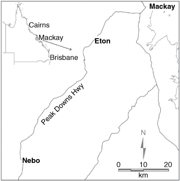
The study occurred on the Peak Downs highway west of Mackay (Fig. 1). It investigated koala road kill clustering and landscape associations that occurred along the 40.7 km stretch of Peak Downs Highway from Nebo Junction to Hazledean. The signed speed limit through this stretch of highway is 100 km/h. The measured traffic speed data has a median of 102.2 km/h (n = 470 874, range 55–135 km/h) (DTMR data Fiery Creek monitoring site January 2016–June 2017). At the time of the study there was no wildlife protection infrastructure in place on this part of the highway. The highway traverses the Clarke-Connors ranges, through a series of ridges and valleys and includes short traverses of undulating alluvial flats. The vegetation is predominantly remnant eucalypt open forest with some small areas of cleared or partially cleared lands, predominantly on the alluvial flats. Eucalyptus drepanophylla dominate the open forests associated with the ridges. Eucalyptus tereticornis and E. platyphylla dominate the minor alluvia associated with the first and second order streams that dissect the ranges as well as the few third and fourth order streams and their associated alluvial flats. The eucalypt open forest is not confined to the road reserve but is part of an extensive forested landscape extending over approximately 400 km of coastal ranges.
|
Interpreting the pattern of koala road kill records
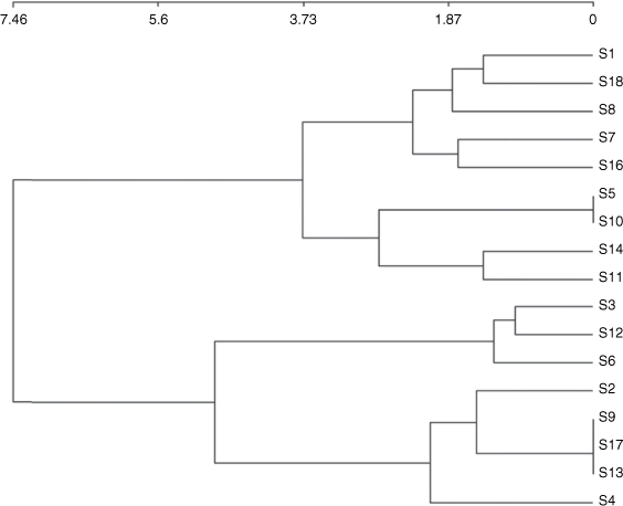
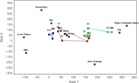
Community volunteers and members of Fauna Rescue Whitsunday monitored the Nebo to Eton stretch of the Peak Downs highway on a daily basis throughout the study period (September 2014–August 2017). The coordinates of koala road kills were recorded with a hand-held GPS (Garmin GPSMAP 64ST) or later derived from the measured road distance from Nebo. The distribution of 69 koala road kills was mapped from Nebo Junction to Hazledean. Each record was given a unique number. These are listed in Table 1. The records were unevenly distributed along the study portion of the highway. This allowed the highway to be divided into road stretches based on whether koala road kills were present or were absent. This visual classification resulted in the highway to be divided into 18 highway stretches. Eleven of these stretches encompassed from 2 to 10 koala road kills. No kills were recorded in the remaining seven stretches. The road kill stretches extended over about 29.4 km (72%) of the 40.7 km study area. The start and endpoint of each stretch was logged as distance in km (±0.01 km) from the DTMR reference point in Nebo using DTMR surveyed ‘chainage’ markers. Broad vegetation descriptions, from field inspections, were made of each road stretch (Table 1). Discrete attributes were derived from the vegetation and landscape description. These included prominent tree species and the types of landform element (Speight 2009) (Table 2). One highway stretch without data (Stretch 15) and rare data (presence/absence of E. raveretiana, Corymbia dallachyana, C. erythrophloia, Melaleuca viridiflora Table 3) were removed from analysis. The remaining set of 17 samples (highway stretches) with 11 variables (Table 2) was analysed using the multivariate analytical software package Community Analysis Package (Pisces Conservation Ltd, www.pisces-conservation.com). Data were investigated using ‘agglomerative cluster analysis’ (Ward’s – Euclidian distance) for the existence of natural grouping in the data set. An analysis of similarity (ANOSIM) was applied to see whether the groups identified in the ‘agglomerative cluster analysis’ were significantly different. The R-statistic was used to indicate the significant differences among the groups. Our examination of those stretches encompassing koala road kills and stretches free of road kills suggested that the koala records may occur across an environmental gradient. Consequently, the clusters and associated attributes were examined using ‘detrended correspondence analysis’ (Hill and Gauch 1980) (DECORANA). This method maps the relationship between sites and attributes, and it is considered particularly useful when data are derived along environmental gradients.

|
|

|
Results
Interpreting the pattern of koala road kills
The 69 koala road kill records had an uneven distribution along the Peak Downs Highway from Nebo Junction to Hazledean. Sixty-nine occurred in 11 highway stretches, with koala records ranging from 2 to 10 per stretch. Among these, Stretch 6 included two isolated records (800 m apart). There were no road kill records associated with the remaining seven stretches (Table 1). The vegetation and landform attributes varied among stretches (Table 3). The dendrogram (Fig. 2) exhibited two major divisions and four significant groups (ANOSIM R = 0.769, P = 0.001). The first level division separated groups 1 and 2 from groups 3 and 4. Groups 1 and 2 were characterised by alluvial flats (Group 1) and lower ridge slopes supporting C. tessellaris (Group 2). Groups 3 and 4 were characterised by ridge upper slopes, ridge crests and hills.
|
The DECORA ordination arranged the clusters and attributes into a generally horizontal pattern (Fig. 3) reflecting a landscape gradient from lowland landform elements and associated tree species (left) to highland elements and tree species (right). The ordination clearly resolved the four groups evident in the dendrogram (Fig. 2). Groups 1 and 2 are at the lowest end of the landscape gradient. Group 4 is at the upper end of the gradient. Group 3 is intermediate. Groups 1, 2 and 3 are associated with koala road kills. There are no kills in Group 4. The highest kill records were associated with groups 1 (N = 5, mean road kills = 5.6, s.d. = 2.9) and 2 (N = 4, mean road kills = 6.5, s.d. = 4.5), with lesser counts for Group 3 (N = 3, mean road kills = 5, s.d. = 3.6) (Table 1).
|
Discussion
This paper examines the distribution of koala road kills along Central Queensland’s Peak Downs Highway as it traverses the Clarke-Connors ranges between Nebo Junction to Hazledean, and identifies an association of road kill occurrence with landform and vegetation attributes.
Koala road kills occurred across a landscape gradient with road kill occurrence highest in lowland habitat and declining upslope to zero in highland habitat. The road kills were associated with (1) streams and associated alluvia where the dominant vegetation included E. tereticornis and E. platyphylla; (2) ridges supporting E. drepanophylla open forest/woodland, where the ridge immediately abutted a stream or alluvia; as well as (3) mid-lower slopes dominated by E. drepanophylla, where the slopes were dissected by minor drainage lines fringed by E. tereticornis ± E. platyphylla or on adjacent minor alluvium. Koala kill records were absent from E. drepanophylla open forest/woodland on the upper slope or crest of ridges and on hills not associated with drainage lines.
The agglomerative clustering results largely reflect the a priori division of highway stretches into two classes, those with and those without koala road kills. There were two exceptions, however, Highway Stretch 11 clustered with group 2 despite having no koala road kill records. Highway Stretch 6, with two road kill records (800 m apart), clustered with Group 3. The vegetation description for highway Stretch 11 suggests that road kills would be expected there. Further investigation is required to ascertain koala usage of that area, and what additional attributes could explain why this highway stretch had a low koala kill frequency. A field inspection of highway Stretch 6 revealed that the two road kill records were each associated with a minor (first order) drainage line fringed by a narrow band of E. tereticornis ± E. platyphylla. The analysis suggests that a separate highway stretch should have encompassed these two road kill records and that two additional stretches without records should be established each side of that stretch.
Other studies and anecdotal accounts indicate that koalas occur in the open forests on the upper slope or crest of ridges and on hills along the highway route (Ellis et al. 2018, K. Harris pers. comm., A. Melzer pers. obs.). The road kills within the study area occurred within an extensive, mostly intact koala habitat landscape. Consequently, questions around habitat patch effects or habitat connectivity do not arise. Rather the question is about why koala road kills were clustered within a broadly occupied koala habitat. Generally, wildlife road kill probability (or risk) seems to be higher in the vicinity of a species’ optimal habitat (e.g. Roger et al. 2012; D’Amico et al. 2015; Balčiauskas et al. 2020) although that is not always the case (Santos et al. 2013). We know from more intensive studies elsewhere in the region (Melzer 1995) that within an occupied habitat koala abundance is greatest on alluvial flats and adjacent lower ridge slopes, with a widespread lower density koala population on the surrounding ridges and hills. Also, in a wide-ranging survey of koalas across the Clarke-Connors ranges, Ellis et al. (2018) most frequently located koalas on the lower slopes and stream flats. So, it is likely that the landscape associated with the kill clusters (groups 1,2 and 3) represents habitat where koala abundance is relatively high and hence the road kill risk is high.
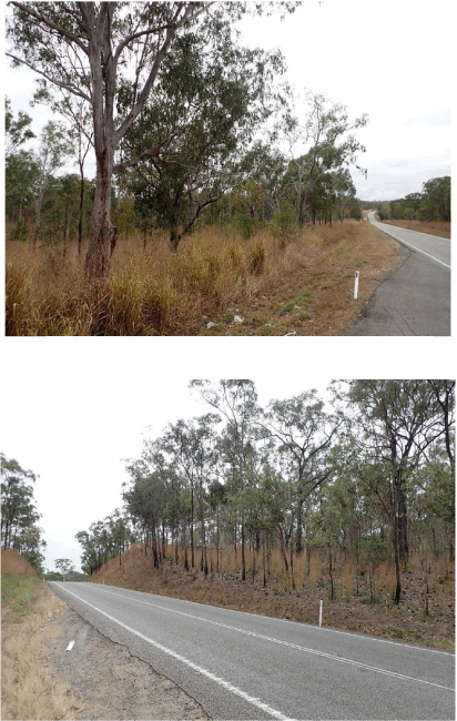
The analysis did not take account of the engineered structural characteristics of the broader road verge associated with the topographical features of the road reserve. This was because along the section of highway studied, the morphology of the road verge closely correlated with the landform element. Road verges on ridge crests and upper slopes were more likely to be characterised by taller/steeper cuttings through the ridges and steep batters over gullies. On the lower slopes, broader valleys and alluvial flats, these engineered features were most likely to be lower, shorter, and less steeply inclined (Fig. 4).
|
It is possible that koalas may be more willing to approach a road where the engineered structures provide the least impediment to movement, and conversely, they may be less inclined to approach a road across a long steeply inclined cutting or batter. More work on koala distribution across the entire landscape, and on koala behaviour around batters and cuttings is required to address this. However, it is likely that any consideration of road kill risk would require the inclusion of both habitat and road engineering parameters.
Despite the limitations, the results provide a basis for the classification of road kill risk and hence, provide a guide to focus potential investment in protective infrastructure. Currently this classification requires field assessment as existing mapping tools, in Qld at least, are at too coarse a scale to resolve smaller landscape and vegetation attributes or provide insufficient information for a desk-top assessment. For example, Qld regional ecosystem (RE) classification and mapping, which incorporates land zone and vegetation attributes (Sattler and Williams 1999), is too coarse to resolve the high road kill risk landscape and vegetation attributes in complex terrain. The RE classification and mapping encompassing Stretch 6 is a polygon combining REs 11.12.1a (90%) and 11.3.4 (10%). This conflates hills and lowlands on granite supporting E. drepanophylla (cluster groups 2, 3 and 4) and alluvium associated with rivers and creeks, supporting E. tereticornis (cluster Group 1). This fails to resolve the first order streams linked to the road kill records in this stretch. In another example, terrain modelling in conjunction with water course and drainage mapping (QGlobe 2021) resolves the minor streams associated with this stretch but does not provide information on soils or vegetation attributes. Field assessment on ground or airborne, is required to undertake the classification at a suitable scale. Finally, the landscape analysis undertaken here has provided a result that gives direction to koala road kill hotspot modelling (e.g. Schlagloth 2018a, 2018b).
Data availability
The data that support this study will be shared upon reasonable request to the corresponding author.
Conflicts of interest
The authors declare no conflict of interest.
Declaration of funding
This project was funded by the Queensland Department of Transport and Main Roads.
Acknowledgements
The support from Queensland Department of Transport and Main Roads for research on koalas and road threats is appreciated. Fauna Rescue Whitsunday volunteers undertook road kill surveys and provided coordinates for each record. Their largely volunteer and in-kind support for this project is greatly appreciated. Ian Denley produced the map for Fig. 1.
References
Balčiauskas, L., Wierzchowski, J., Kučas, A., and Balčiauskienė, L. (2020). Habitat suitability based models for ungulate roadkill prognosis. Animals 10, 1345.| Habitat suitability based models for ungulate roadkill prognosis.Crossref | GoogleScholarGoogle Scholar |
Bond, A. R., and Jones, D. N. (2008). Temporal trends in fauna-friendly underpasses and overpasses. Wildlife Research 35, 103–112.
| Temporal trends in fauna-friendly underpasses and overpasses.Crossref | GoogleScholarGoogle Scholar |
D’Amico, M., Román, J., de los Reyes, L., and Revilla, E. (2015). Vertebrate road-kill patterns in Mediterranean habitats: who, when and where. Biological Conservation 191, 234–242.
| Vertebrate road-kill patterns in Mediterranean habitats: who, when and where.Crossref | GoogleScholarGoogle Scholar |
de Oliveira, S. M., Murray, P. J., de Villiers, D. L., and Baxter, G. S. (2013). Ecology and movement of urban koalas adjacent to linear infrastructure in coastal south-east Queensland. Australian Mammalogy 36, 45–54.
| Ecology and movement of urban koalas adjacent to linear infrastructure in coastal south-east Queensland.Crossref | GoogleScholarGoogle Scholar |
Dexter, C. E., Appleby, R. G., Edgar, J. P., Scott, J., and Jones, D. N. (2016). Using complementary remote detection methods for retrofitted eco-passages: a case study for monitoring individual koalas in south-east Queensland. Wildlife Research 43, 369–379.
| Using complementary remote detection methods for retrofitted eco-passages: a case study for monitoring individual koalas in south-east Queensland.Crossref | GoogleScholarGoogle Scholar |
Dique, D. S., Thompson, J., Preece, H. J., Penfold, D. L., de Villiers, D. L., and Leslie, R. S. (2003). Koala mortality on roads in south-east Queensland: the koala speed-zone trial. Wildlife Research 30, 419–426.
| Koala mortality on roads in south-east Queensland: the koala speed-zone trial.Crossref | GoogleScholarGoogle Scholar |
Dudaniec, R. Y., Rhodes, J. R., Wilmer, J. W., Lyons, M., Lee, K. E., McAlpine, C. A., and Carrick, F. N. (2013). Using multilevel models to identify drivers of landscape-genetic structure among management areas. Molecular Ecology 22, 3752–65.
| Using multilevel models to identify drivers of landscape-genetic structure among management areas.Crossref | GoogleScholarGoogle Scholar | 23730800PubMed |
Ellis W., FitzGibbon S. and Barth B. (2018). Koalas of the Clarke Connors Range: final report of progress October 2018. A report to the Department of Transport and Main Roads. Koala Ecology Group, Brisbane.
Goldingay, R. L., Taylor, B. D., Parkyn, J. L., and Lindsay, J. M. (2018). Are wildlife escape ramps needed along Australian highways? Ecological Management & Restoration 19, 198–203.
| Are wildlife escape ramps needed along Australian highways?Crossref | GoogleScholarGoogle Scholar |
Goldingay, R. L., Taylor, B. D., and Parkyn, J. L. (2019). Movement of small mammals through a road-underpass is facilitated by a wildlife railing. Australian Mammalogy 41, 142–146.
| Movement of small mammals through a road-underpass is facilitated by a wildlife railing.Crossref | GoogleScholarGoogle Scholar |
Gonzalez-Astudillo, V., Allavena, R., McKinnon, A., Larkin, R., and Henning, J. (2017). Decline causes of Koalas in South East Queensland, Australia: a 17-year retrospective study of mortality and morbidity. Scientific Reports 7, 42587.
| Decline causes of Koalas in South East Queensland, Australia: a 17-year retrospective study of mortality and morbidity.Crossref | GoogleScholarGoogle Scholar | 28218272PubMed |
Goosem, M., and Marsh, H. (1997). Fragmentation of a small-mammal community by a powerline corridor through tropical rainforest. Wildlife Research 24, 613.
| Fragmentation of a small-mammal community by a powerline corridor through tropical rainforest.Crossref | GoogleScholarGoogle Scholar |
Hill, M. O., and Gauch, H. G. (1980). Detrended correspondence analysis: an improved ordination technique. Vegetatio 42, 47–58.
| Detrended correspondence analysis: an improved ordination technique.Crossref | GoogleScholarGoogle Scholar |
Jackson S. (2007). ‘Koala; origins of an icon’. (Jacana Books, Allen and Unwin: Alexander St, Crows Nest, NSW.)
Jones, M. E. (2000). Road upgrade, road mortality and remedial measures: impacts on a population of eastern quolls and Tasmanian devils. Wildlife Research 27, 289–296.
| Road upgrade, road mortality and remedial measures: impacts on a population of eastern quolls and Tasmanian devils.Crossref | GoogleScholarGoogle Scholar |
Lassau S. A., Ryan B., Close R., Moon C., Geraghty P., Coyle A., and Pile J. (2008) Home ranges and mortality of a roadside koala Phascolarctos cinereus population at Boniville, New South Wales. In ‘Too close for comfort: contentious issues in human-wildlife encounters’. (Eds D. Lunney, A. Munn, W. Meikle) pp. 127–136. (Royal Zoological Society of New South Wales: Mossman, NSW, Australia.)
Laurance, W. F., Goosem, M., and Laurance, S. G. W. (2009). Impacts of roads and linear clearings on tropical forests. Trends in Ecology and Evolution 24, 659–669.
| Impacts of roads and linear clearings on tropical forests.Crossref | GoogleScholarGoogle Scholar | 19748151PubMed |
Lee, K. E., Seddon, J. M., Corley, S. W., Ellis, W. A. H., Johnston, S. D., de Villiers, D. L., Preece, H. J., and Carrick, F. N. (2010). Genetic variation and structuring in the threatened koala populations of Southeast Queensland. Conservation Genetics 11, 2091–2103.
| Genetic variation and structuring in the threatened koala populations of Southeast Queensland.Crossref | GoogleScholarGoogle Scholar |
McAlpine, C., Lunney, D., Melzer, A., Menkhorst, P., Phillips, S., Phalen, D., Ellis, W., Foley, W., Baxter, G., de Villiers, D., Kavanagh, R., Adams-Hosking, C., Todd, C., Whisson, D., Molsher, R., Walter, M., Lawler, I., and Close, R. (2015). Conserving koalas: A review of the contrasting regional trends, outlooks and policy challenges. Biological Conservation 192, 226–236.
| Conserving koalas: A review of the contrasting regional trends, outlooks and policy challenges.Crossref | GoogleScholarGoogle Scholar |
Melzer A. (1995). Aspects of the ecology of the koala Phascolarctos cinereus (Goldfuss, 1817) in the sub-humid woodlands of Central Queensland. PhD thesis, University of Queensland, Brisbane, Qld.
Melzer A., Black L. and Gottke A. (2018a) Wildlife mortality on the Nebo to Eton stretch of the Peak Downs Highway, Central Queensland. Koala Research CQ, School of Medical and Applied Sciences, CQUniversity, Rockhampton.
Melzer A., Santamaria F., and Allen S. (2018b). The koalas, koala habitat and conservation management in the Clarke-Connors Ranges and associated landscapes. A report to the Queensland Department of Transport and Main Roads. Koala Research CQ, School of Medical and Applied Sciences, CQUniversity, Rockhampton.
NRMMC (2009). National Koala Conservation and Management Strategy 2009–2014. Natural Resource Management Ministerial Council, Department of the Environment, Water, Heritage and the Arts, Canberra.
NSW DPIE (2020). Wildlife vehicle strike and contributing factors; Koala vehicle strike fact sheet 1. Environment, Energy and Science, Department of Planning, Industry and Environment, Locked Bag 5022, Parramatta, NSW 2124.
NSW RMS (2015). Fauna connectivity strategy, Woolgoolga to Glenugie (sections 1 and 2), Pacific Highway Upgrade, Woolgoolga to Ballina. NSW Roads and Maritime Services, North Sydney, NSW.
NSW RMS (2019a). Fauna fencing specifications and design. Appendix G1 in Pacific Highway Upgrade, Woolgoolga to Ballina; Fauna connectivity strategy (sections 3–11). NSW Roads and Maritime Services, North Sydney, NSW.
NSW RMS (2019b). Pacific Highway Upgrade, Woolgoolga to Ballina; Fauna connectivity strategy (sections 3-11). NSW Roads and Maritime Services, North Sydney, NSW.
QGlobe (2021). Queensland Globe, vegetation management water course/drainage layers. Available at https://qldglobe.information.qld.gov.au/
QLD DERM (2011). Summary of koala hospital presentations, releases and major causes of death, 1997 to beginning of mid May 2011 - Southeast Queensland. Queensland Department of Environment and Resource Management, Brisbane.
Qld DTMR (2000). Fauna sensitive road design manual (Volume 1) – Past and existing practices. Department of Transport and Main Roads, Brisbane Qld.
Qld DTMR (2010). Fauna sensitive road design manual (Volume 2). Department of Transport and Main Roads, Brisbane Qld.
Roger, E., Bino, G., and Ramp, D. (2012). Linking habitat suitability and road mortalities across geographic ranges. Landscape Ecology 27, 1167–1181.
| Linking habitat suitability and road mortalities across geographic ranges.Crossref | GoogleScholarGoogle Scholar |
Santos, S., Lourenco, R., and Beja, P. (2013). Relative effects of road risk, habitat suitability, and connectivity on wildlife roadkills: The case of tawny owls (Strix aluco). Plos One 8, e79967.
| Relative effects of road risk, habitat suitability, and connectivity on wildlife roadkills: The case of tawny owls (Strix aluco).Crossref | GoogleScholarGoogle Scholar | 24278226PubMed |
Sattler P. S. and Williams R. D. (Eds) (1999). ‘The conservation status of Queensland bioregional ecosystems’. (Environmental Protection Agency: Brisbane.)
Schlagloth R. (2018a). Modelling koala road-kill blackspots. PhD thesis, Central Queensland University, Rockhampton, Qld.
Schlagloth R. (2018b). Managing Central Queensland’s Clarke Connors Range koala population Predicting future koala road-kill hotspots. A report to the Department of Transport and Main Roads, Qld. Koala Research-CQ, School of Medical and Applied Sciences, CQUniversity, Rockhampton.
Spanowicz, A. G., Zimmermann, T., and Jaeger, A. G. (2020). An adaptive plan for prioritizing road sections for fencing to reduce animal mortality. Conservation Biology 34, 1210–1220.
| An adaptive plan for prioritizing road sections for fencing to reduce animal mortality.Crossref | GoogleScholarGoogle Scholar | 32227646PubMed |
Speight J. G. (2009). Landform. In ‘Australian soil and land survey field handbook’, 3rd edn. (The National Committee on Soil and Terrain. CSIRO: Collingwood, Victoria.)
Taylor, B. D., and Goldingay, R. L. (2010). Roads and wildlife: impacts, mitigation and implications for wildlife management in Australia. Wildlife Research 37, 320–331.
| Roads and wildlife: impacts, mitigation and implications for wildlife management in Australia.Crossref | GoogleScholarGoogle Scholar |
van der Ree, R., Jaeger, J. A. G., van der Grift, E. A., and Clevenger, A. P. (2011). Effects of roads and traffic on wildlife populations and landscape function: road ecology is moving towards larger scales. Ecology and Society 16, 48.
| Effects of roads and traffic on wildlife populations and landscape function: road ecology is moving towards larger scales.Crossref | GoogleScholarGoogle Scholar |
VicRoads (2012). Fauna sensitive road design guidelines. VicRoads Environmental Sustainability, VicRoads, Melbourne, Vic.