

Characterising spatial clusters of forest fire activity in the Western Himalayan region of India: implications for conservation and management
Shanti Kumari A B , Shailja Mamgain A B , Arijit Roy A * and H. C. Prince AA
B
Abstract
Forest fires in Western Himalaya have exhibited changing patterns over past years due to climatic change and human activities. Understanding these fire patterns is essential for developing effective conservation and management strategies.
This study characterises spatial clusters of forest fires and analyses their spatio-temporal patterns across Western Himalaya using long-term data (2005–2022) on fire events, burned area and climatic variables.
The study employs Getis-Ord Gi* and Anselin Local Moran’s I statistics to identify significant spatial clusters of forest fire activity. Furthermore, time-series analysis combined with the Mann–Kendall test are utilised to evaluate the relationship between fire events and climatic and edaphic variables.
Analysis revealed statistically significant clusters of forest fires concentrated in low to mid-elevation regions, which comprise 27–32% of total forest area. These burned areas are primarily located in Uttarakhand and parts of Himachal Pradesh, particularly in the central and south-eastern districts of Pauri and Tehri, indicating a heightened risk of forest fires.
Identification of forest fire clusters and the assessment of contributing factors provide crucial insights into the underlying causes of their activity in the Western Himalaya.
Findings of this study will be instrumental in developing targeted mitigation strategies to protect vulnerable ecological resources in Western Himalaya.
Keywords: Anselin Local Moran’s I statistics, climatic drivers, forest fire clusters, forest fire dynamics, Getis-Ord hotspot analysis, spatio-temporal analysis, vegetation type, Western Himalaya.
Introduction
Forest fires have widespread impacts on ecosystem globally, affecting not only vegetation but also the complex interactions within them (Chaideftou 2022; Roces‐Díaz et al. 2022). Their effects extend beyond immediate burning, leading to ecological losses and cascading impacts on society and the environment (Burrows 2008; Kala 2023). The variability in the spatial and temporal patterns of forest fires is primarily driven by a combination of environmental conditions, weather patterns and human activities, which together influence fire ignition and spread (Gupta et al. 2020). Additionally, the risks associated with forest fires are further exacerbated by climate change, which alters fuel availability and moisture levels, thereby intensifying fire hazards. Studies carried out across the world (Dupuy et al. 2020; Halofsky et al. 2020; Adams and Neumann 2023; Barik and Baidya Roy 2023) have indicated that climatic shifts, coupled with changes in fuel availability and moisture, play a significant role in shaping global fire patterns.
In this context, the Western Himalaya, characterised by frequent fire occurrences and recognised as a globally significant biodiversity hotspot, emerges as a particularly intriguing area for studying forest fire dynamics (Ahmad and Saran 2023). In recent decades, this region has witnessed a significant increase in forest fire incidents, a trend attributed to the combined impact of anthropogenic pressures and shifting climatic regimes. The Western Himalaya’s unique geography, characterised by rugged terrain and remote areas, presents substantial challenges for fire management efforts. Unlike regions with established fire monitoring systems, such as Europe and North America, the challenging terrain and limited accessibility of the Western Himalaya hinder effective fire assessment and control (Dobriyal and Bijalwan 2017). Furthermore, most accessible areas are already subject to various land uses and impacted by human activities, further complicating fire management efforts.
Despite advances in satellite technology and remote sensing that have enhanced global fire detection capabilities, a significant knowledge gap persists regarding the interplay of environmental, climatic and socio-economic factors shaping forest fire dynamics, particularly within the Western Himalayan region. Existing research has often focused on isolated aspects of fire dynamics, leaving a critical gap in understanding how these factors interact within the specific context of the Western Himalaya (Bargali et al. 2022; Bhatt et al. 2022; Ahmad and Saran 2023). Also, statistical tools such as Autoregressive Integrated Moving Average models (ARIMA) (Li et al. 2021; Jesus et al. 2022; Su et al. 2023) and Generalised Linear Mixed Models (GLMM) (Miller and Safford 2012) have been used by other studies to analyse temporal fire patterns. However, these methods may not fully account for the spatial and climatic variability inherent in fire dynamics (Mamgain et al. 2023). Similarly, unsupervised machine learning clustering techniques, such as Density-based Spatial Clustering of Applications with Noise (DBSCAN) and Hierarchical Density-Based Spatial Clustering of Applications (HDBSCAN), have been utilised to identify clusters of fire activity (Coogan et al. 2022; Su et al. 2023). However, these approaches often fail to fully integrate the broader climatic and environmental context.
Climate change, through shifts in temperature and precipitation, and human activities, such as agricultural expansion, logging and forest product collection, significantly alter fire risk by modifying fuel loads and increasing ignition sources (Fréjaville and Curt 2017). Therefore, a comprehensive assessment of spatio-temporal fire patterns in the Western Himalaya necessitates a multi-faceted approach that integrates scientific research, technological advancements, community engagement and robust policy support.
The present study hypothesises that the spatial and temporal patterns of forest fires in the Western Himalaya are influenced by environmental, topographic and climatic factors, which can be analysed using satellite data and spatial techniques. It further posits that the frequency and intensity of fires exhibit significant trends linked to these factors. Finally, the study anticipates that understanding these patterns will reveal ecological implications and support the development of effective fire risk mitigation strategies.
To address these hypotheses, this study aims to identify and analyse spatial and temporal patterns of forest fires using satellite-derived variables, spatial clustering techniques and autocorrelation methods. Secondly, the study seeks to determine the influence of environmental, topographic and climatic factors on forest fire frequency and intensity through statistical analyses, including correlation and trend analysis, for the Western Himalayan region of India. Further, this study intends to develop insights into the ecological implications of fire patterns and contribute to the formulation of targeted fire risk mitigation strategies.
Study area
Western Himalayan states including Uttarakhand and Himachal Pradesh, shown in Fig. 1, are vulnerable to frequent forest fires. This vulnerability comes from a combination of factors such as topography, climatic conditions and the agricultural dependence of residents. Over the last two decades, these states have experienced significant episodes of such fires. The region’s topography varies from valley to plains at the foothills of the Himalayas, with transition in vegetation from tropical forests to high-elevation alpine meadows and treeline ecosystems (Reddy et al. 2015). Precipitation in the region varies between 600 and 4000 mm annually, with most occurring between July and September and significant precipitation during winter. The average temperature ranges between 15 and 40°C and drops to negative values in the mountains, which remain covered with snow. Forest fires are linked to pre- and post-monsoon parameters (i.e. precipitation and temperature). Higher temperatures post monsoon heighten fire risk and vice versa. Also, pre-fire litter accumulation increases forest susceptibility to ignition, exacerbating fire risk during periods of elevated temperatures and low humidity (Adams and Neumann 2023).
(a) Location and distribution of vegetation type within the study area (DDF, Dry Deciduous Forest; MDF, Moist Deciduous Forest); (b) spatial distribution of fire occurrence points (March 2016); and (c) visualisation of study area with respect to digital elevation model.
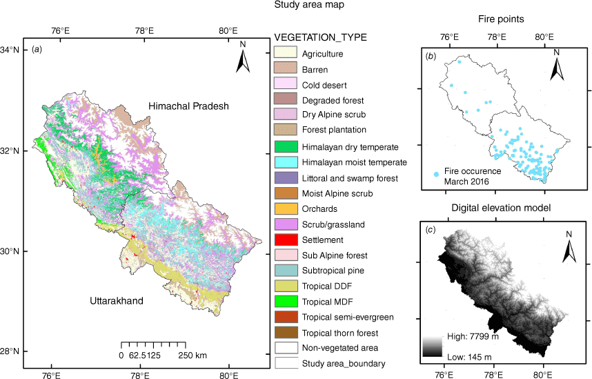
The study focuses on elevations above 500 m up to the tree line, as areas beyond are snow-covered and have no reported fire incidents.
Materials and method
Materials
The Normalized Differenced Vegetation Index (NDVI) and Modified Normalized Difference Fire Index (MNDFI) are valuable tools for understanding vegetation health in response to forest fire (Dang et al. 2021; Kumari et al. 2024), and they also indirectly inform us about fuel availability. The NDVI provides insights into the amount of live vegetation, a key component of fuel. It decreases significantly during fire, based on near-infrared (NIR) and red (R) bands (Digavinti and Manikiam 2021), whereas the MNDFI increases sharply during forest fires owing to its ability to identify burned areas, based on NIR and short-wave infrared (SWIR) bands. Daily surface reflectance images acquired from MOD09GA are used to derive the above indices based on the following equation and respective spectral band combinations:
Satellite-derived daily land surface temperature (LST) data provide insights into the thermal characteristics of land surfaces. Higher LSTs indicate drier vegetation due to less moisture, making it more susceptible to ignition. However, other factors such as solar radiation, atmospheric conditions and land cover also influence LST.
Surface Soil Moisture (SSM), obtained from the Soil Moisture Active Passive (SMAP) mission, measures moisture content in the top few centimetres of soil surfaces. Dry soil contributes to rapid fire spread and intensifies fires by creating drier fuel conditions. Owing to the limited availability of in situ or alternative high-resolution moisture datasets, coarser-resolution SSM from SMAP was used in this study.
Rainfall data derived from CHIRPS – Climate Hazard Group Infrared Precipitation with Station (Funk et al. 2015) – were used in the present work to understand the consequences of rainfall patterns on forest fire.
A DEM (digital elevation model) from SRTM (Shuttle Radar Topography Mission) was used to extract the altitudinal distribution of vegetation types in the Western Himalaya. Differences in slope and aspect create microclimatic zones in hilly regions, which in turn influence the composition and structure of vegetation. Forest fire incidence changes as vegetation composition changes in relation to its associated plant species.
This study utilises active fire records along with burnt area data. We prioritise fires with high confidence intervals and high Fire Radiative Power (FRP) values. As meteorological parameters are dynamic in nature, active fires data are preferred over monthly or annual burnt area records to better observe patterns in environmental variables alongside fire incidents. Forest fire alters weather patterns, potentially leading to increased temperatures and unexpected rainfall due to elevated humidity and heat. These changes in turn affect other phenomena such as phonological activity (e.g. NDVI, MNDFI) and soil moisture (SSM). Therefore, we prioritise the instantaneous information provided by active fire records to gain detailed insight into environmental conditions during fire episodes (Giglio et al. 2016).
All input datasets listed in Table 1 were resampled to the same resolution using a nearest-neighbour method to ensure consistency in spatial resolution for analysis purposes. The historic time series from 2005 to 2022 considered for the present study aimed to understand the complex relationship between climate and fire occurrence by discerning temporal patterns, seasonal variability and trends in climatic variables.
| Satellite-derived dataset | Time period | Spatial resolution | Source | |
|---|---|---|---|---|
| Fire alerts (MOD14/MYD14) | 2005–2022 | 1 × 1 km | https://firms.modaps.eosdis.nasa.gov/ and https://appeears.earthdatacloud.nasa.gov/explore | |
| Burnt area (MCD64A1) | ||||
| Daily surface reflectance (NDVI, MOD09GA) | 2005–2022 | 1 × 1 km | https://lpdaac.usgs.gov/ | |
| MNDFI | 2005–2022 | 1 × 1 km | ||
| Land surface temperature (LST, MYD11A1) | 2005–2022 | 1 × 1 km | https://lpdaac.usgs.gov/ | |
| Precipitation (CHIRPS) | 2005–2022 | 5566 m | https://chc.ucsb.edu/data/chirps | |
| Surface soil moisture (SSM) | 2015–2022 | 9 km | https://nsidc.org/data/spl3smp_e/ | |
| Digital elevation model (elevation, slope, aspect) | 2002 | 90 m | https://srtm.csi.cgiar.org/srtmdata/ | |
| Vegetation type | 2005–10 | 23.5 × 23.5 m | Roy et al. (2015) |
Methods
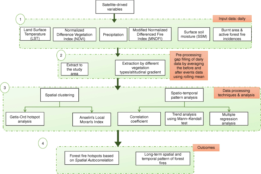
The methodology for the study is outlined in Fig. 2. Steps 1 and 2 involve stages of database preparation from downloading to pre-processing. Step 3 describes the statistical approach used to achieve the objectives: first, a response study of environmental and metrological drivers of fire events with respect to specific vegetation over the long term using the Mann–Kendall test and multiple regression analysis; second, spatial clustering and hotspot analysis using Getis-Ord and Local Moran’s I to determine whether fire events are concentrated in specific areas (hotspot zones), or are sporadic (coldspot zones). The null hypothesis for the study is that the clustering nature of fire events does not significantly respond to specific vegetation types or environmental factors in the Western Himalaya region. Finally, Step 4 focuses on map preparation and analysis of the results including the long-term spatio-temporal patterns of forest fire and spatial autocorrelation map.
Data processing and analysis
Spatial clustering and hotspot analysis were conducted to identify areas with significant fire occurrences. Two methods were employed: Getis-Ord Gi* and Local Moran’s I. Getis-Ord’s Gi* identifies clusters of high or low fire incidence values based on spatial relationships between data points. It calculates Gi-Bin values, z-scores and P-values to determine if fire incidences are clustered, dispersed, or randomly distributed (Ord and Getis 1995), whereas Local Moran’s I identifies local spatial autocorrelations, categorising areas as high–high clusters (high fire incidence surrounded by high incidence), low–low clusters (low incidence surrounded by low incidence) and outliers (high incidence surrounded by low incidence or vice versa) (Anselin 1995). The statistics derived from the Local Moran’s I method differ from those of Getis-Ord, because it calculates local spatial covariance instead of relying on summed values. The consistent identification of similar clusters by both methods strengthens the confidence in the results, acting as a form of cross-validation.
Different vegetation types are adapted to specific environmental conditions, resulting in distinct patterns in their distribution. The type, quantity and moisture content of vegetation, along with dry grasses and accumulated leaf litter, increase the fuel load, so specific vegetation types were selected based on a literature survey to characterise spatial clusters of forest fire by vegetation types. Champion and Seth (1968) proposed 16 types of forests present in India, out of which 14 types exist in Western Himalaya (Roy et al. 2015). Among these, Himalayan Moist Temperate, Tropical Dry Deciduous, Subtropical Pine, Forest plantation, Himalayan Dry Temperate, Degraded Forest, Dry Alpine Forest and Scrub–Grassland vegetation types are most affected by forest fires, as discussed in the following section. The incidence of fire on Alpine Forest, Degraded Forest and Himalayan Dry Temperate were fewer from hotspot counts throughout the year.
In this study, Theil–Sen-Slope and Mann–Kendall tests were used to analyse the temporal fluctuation and spatial variability of indicator parameters, including LST, NDVI, MNDFI, SSM and precipitation for forest fire incidence in selected vegetation.
The Theil–Sen-Slope test estimates the slope of the relationship between pairs, whereas the Mann–Kendall test detects either an increasing or decreasing trend between pairs (Kendall 1948; Sen 1968). These statistical analyses were complemented by line plots and multiple regression methods. The study employed multiple linear regression to analyse the relationship between the dependent variable (forest fire incidence) and independent variables (LST, MNDFI, NDVI, precipitation and surface soil moisture). This method allows the simultaneous analysis of relationships between a dependent variable and multiple predictors. The statistics calculated include z-score, adjusted R2 and P-values to estimate the magnitude and direction of all five indicators (Neeti and Eastman 2011). A positive slope value indicates an increasing trend, whereas a negative slope value indicates a decreasing trend of the indicators (Legates and McCabe 1999). Additionally, a statistically significant trend has a P-value of less than 0.05.
Results
The long term spatio-temporal patterns of forest fire identified spatial clusters of fire incidences that show a significant relationship to various environmental parameters in the Western Himalaya. These findings are elaborated in the following sections.
Analysis of burnt area and forest fire incidences with the vegetation distribution
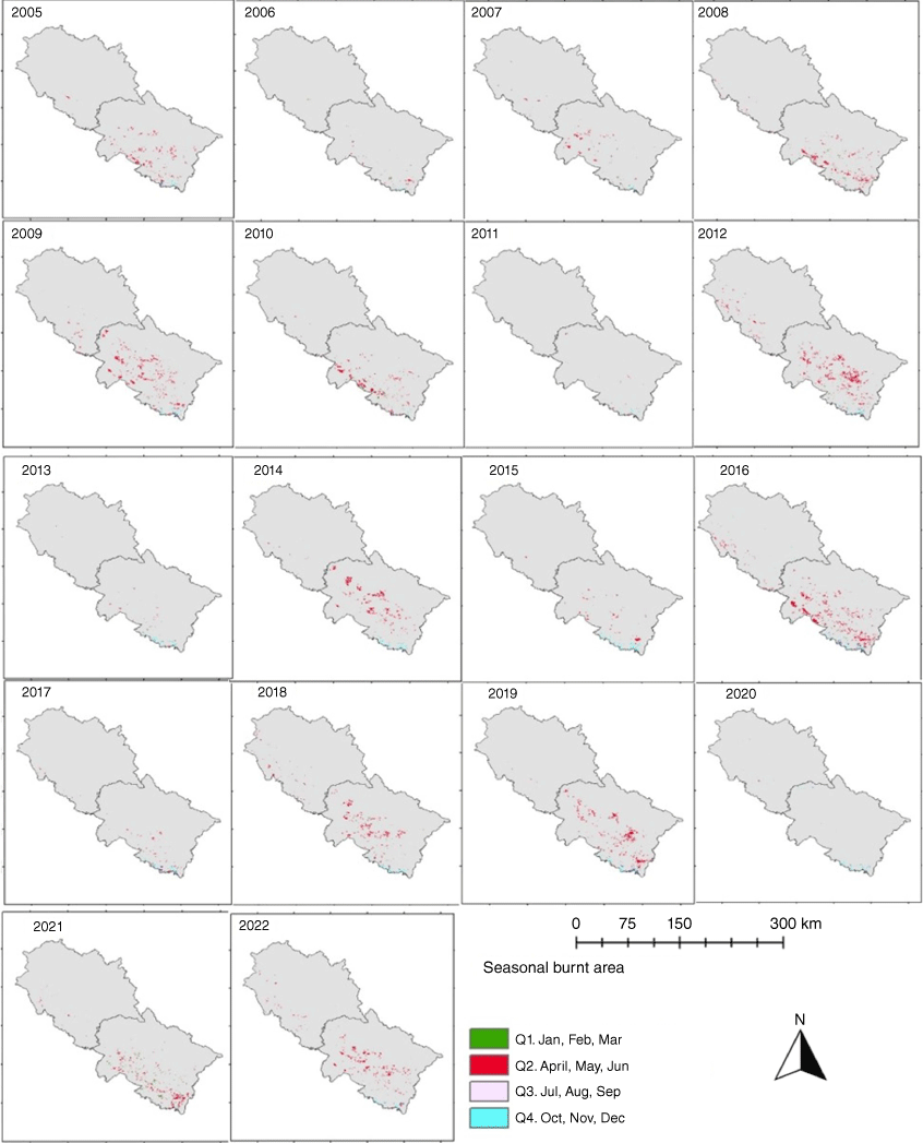
Monthly burnt area was estimated for the period 2005–2022 and then aggregated quarterly for each year as shown in Fig. 3, (Q1: January–March, Q2: April–June, Q3: July–September and Q4: October–December). The annual burnt area in the Western Himalaya varied between 177 and 2790 km2 over the study duration. The highest burnt areas recorded for the duration 2005–2022 by decreasing area affected were during 2016 (2790 km2), 2012 (2590 km2), 2019 (1935 km2), 2009 (1884 km2), 2014 (1583 km2), 2022 (1574 km2) and 2018 (1546 km2). Burnt areas were observed primarily over central and southeast regions of Uttarakhand state. Quarter 2 (Q2: April, May, June) had the maximum fire occurrences compared with other quarters and coincides with the fire season in Indian Himalaya.
Seasonal distribution of burnt areas analysed annually at a 1 × 1 km resolution. (Q1, Quarter 1; Q2, Quarter 2; Q3, Quarter 3; and Q4, Quarter 4).
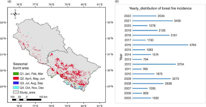
The cumulative burnt area for the entire study duration from 2005 to 2022 was 22,048 km2, constituting nearly 40% of the forest areas in Uttarakhand and 7% of forest areas in Himachal Pradesh, shown in Fig. 4a. Over this 18-year period, more than 37,000 forest fire events were reported across both states, averaging ~1000 fire incidences per year, as shown in Fig. 4b. This study focuses only on forest fires and excludes agricultural fires, which are more prevalent in areas below 500 m and contribute approximately a quarter of the total fire incidences. The spatial statistics of the distribution of burnt area over altitude gradient and in various vegetation types are shown in Fig. 5a, b respectively. Maximum fire incidences were observed below an altitude of 2000 m, with the most significant impact observed in vegetation types at this elevation including Topical Dry Deciduous, Subtropical Pine Forest, Scrub–grassland and Himalayan Dry Temperate Forest.
(a) Cumulative seasonal burnt area affected by forest fires from 2005 to 2022; and (b) annual number of forest fire incidents from 2005 to 2022 within the study area.
(a) Fire incidences at different altitude gradients. (b) Distribution of vegetation type along altitude gradients. (c) Burnt area in selected vegetation type of Uttarakhand and Himachal Pradesh. (d) Fire count in selected vegetation types of Uttarakhand and Himachal Pradesh.
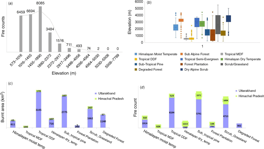
In Uttarakhand between 2005 and 2022, 10% of the cumulative burnt area, comprising 3145 km2, involved 6194 fire incidents in Topical Dry Deciduous Forest. Similarly, 9% of the area, encompassing 2775 km2, involved 5741 fire incidents in Subtropical Pine forest, followed by Scrub–Grassland with 6% of the burnt area (1460 km2) and 4713 fire incidents. Himalayan Dry Temperate forest experienced 1.2% of the total burnt area (232 fire incidents), and degraded forest with 1% of the burnt area (902 fire incidents). It is important to note that the burnt area in Himachal Pradesh is significantly less compared with Uttarakhand (Fig. 5c). However, the impact of fires in Himachal Pradesh’s Himalayan Dry Temperate Forest may be more severe owing to the larger area occupied by this forest type. This observation also indicates that fire incidents are more numerous in the regions below 2500 m altitude (Fig. 5a, b).
Spatial and temporal inter-relation of fire events with environmental variables
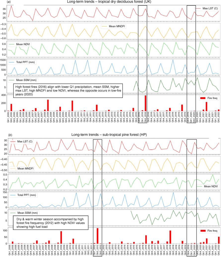
The long-term spatial and temporal patterns of forest fire incidences in the Tropical Dry Deciduous (TDD) forest in Uttarakhand and Subtropical Pine (STP) forest in Himachal Pradesh with respect to the following parameters: NDVI, MNDFI (proxy for fuel moisture), LST, soil moisture (Fig. 6a, b) and for other vegetation types are shown in Supplementary Fig. S2. The spatio-temporal analysis reveals a clear link between fire incidence and environmental conditions. Notably, the high fire occurrence in Uttarakhand Tropical Dry Deciduous forests during the second quarter of 2016 coincided with significantly high temperatures and low precipitation in the preceding 6 months. This combination likely resulted in drier vegetation, as evidenced by the low NDVI values and high MNDFI values recorded during that period. A similar pattern is observed in the TDD forests of Uttarakhand during 2008 (Fig. 6a) and the STP forests of Himachal Pradesh in 2012 (Fig. 6b). These observations reaffirm that drier weather preceding the fire season leads to high fire incidence and intensity in the Western Himalaya. Conversely, periods with high rainfall and lower temperatures during winter months preceding the fire season, as seen in 2011, 2014 and 2020, result in fewer fires in the region owing to increased moisture levels in vegetation.
(a) Spatio-temporal trends of forest fire incidence with variables influencing forest fire (LST, NDVI, MNDFI, SSM and rainfall) in Uttarakhand (UK) Tropical Dry Deciduous forests. (b) Spatio-temporal trends of forest fire incidences with variables influencing forest fire (LST, NDVI, MNDFI, SSM and rainfall) in Himachal Pradesh (HP) Subtropical Pine forests.
Trend analysis of forest fire incidences and environmental variables
The z-scores in Table 2 indicate the direction and strength of the trends for all environmental variables across different vegetation types in Uttarakhand and Himachal Pradesh. Positive z-scores (values > 0) represent increasing trends, while negative values signify decreasing trends. The magnitude of the z-score reflects the strength of the trends.
| Forest type | Fire count | LST | MNDFI | NDVI | Precipitation | SSM | |
|---|---|---|---|---|---|---|---|
| Himalayan Moist Temperate | 1.11 | −0.52 | −0.25 | 0.99 | 1.48 | 3.98 | |
| Sub-Alpine Forest | 1.94 | 1.94 | −0.29 | 2.10 | 1.88 | 2.16 | |
| Tropical DDF | −1.04 | −0.61 | −1.82 | 1.57 | 1.71 | 2.38 | |
| Himalayan Dry Temperate | 0.27 | −0.26 | −0.23 | 0.23 | 1.91 | 6.02 | |
| Subtropical Pine | 1.34 | −0.95 | −1.30 | 1.77 | 1.59 | 2.69 | |
| Forest Plantation | −0.31 | −0.90 | −1.84 | −0.55 | 1.46 | 3.65 | |
| Scrub Grassland | 1.54 | −0.62 | −2.55 | 1.76 | 1.56 | 2.84 | |
| Degraded Forest | 1.20 | −1.05 | −0.01 | 0.95 | 1.54 | 2.41 |
The temporal trend analysis of fire incidence, using the above-mentioned statistical tools, reveals a significant decreasing trend over the years in Tropical Dry Deciduous forests and forest plantations (Table 2). Conversely, all other vegetation types demonstrate a significant increase in fire incidence. Interestingly, fire incidence rises even in regions with decreasing LST, MNDFI and increasing precipitation and soil moisture.
The regression coefficients obtained for different vegetation types are provided in Supplementary Table S1 and for the individual states, refer to Supplementary Table S2 and Supplementary Fig. S3. This analysis revealed a strong relationship with independent variables, supported by a high adjusted R2 (>0.6) and a low P-value (<0.05).
Analysis of hotspot and cluster response
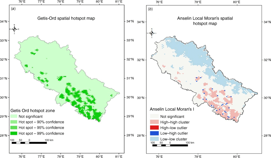
Fire incidents from 2005 to 2022 were analysed for identification of hotspots and cluster response using Getis-Ord and Anselin’s Local Moran’s method. High probability of spatial clustering is indicated by larger z-scores and lower P-values; refer to Supplementary Tables S3 and S4. Conversely, lower z-scores and higher P-values suggest a low clustering probability of the distribution of forest fire incidents. In Fig. 7a (Getis-Ord analysis), darker green areas represent fire hotspots (99% confidence interval) with high Getis-Ord Gi* z-score (GiZ) scores (>2.5) and low Getis-Ord Gi* P-value (GiP) values. Meanwhile, Fig. 7b (Anselin’s Local Moran’s analysis) reveals that the high–high (HH) clusters, represented in pink, significantly overlap with the hotspots identified through Getis-Ord. Hotspot analysis using Getis-Ord in the Western Himalaya found ~27% (40,462 km2 of total forest area) as fire hotspot with 99% confidence level. Anselin’s Local Moran (LMi) analysis found that nearly 32% of the area falls within HH clusters with a positive Local Moran’s I value (>0.02 to 196), high z-score (1.84 to 11.19) and low P-value (>0.05), suggesting a possible overestimation. Getis-Ord is utilised as a local measure to visualise and detect spatial autocorrelation. It allows users to set confidence levels to determine the significance of identified clusters of high or low values. However, Anselin’s method focuses on global measures, indicating whether similar values (high–high or low–low) tend to be clustered. Employing local as well as global statistics serves to cross-validate the results, providing stronger support for the outcomes in this study.
Discussion
Forest fires in the Western Himalaya show distinct seasonality as well as spatial clustering and are influenced by various environmental and topographical factors (Ganteaume et al. 2013). These factors include vegetation type, topography (altitude, aspect and slope), temperature and precipitation patterns, and edaphic factors (Prasad et al. 2008). Development of these factors over time, along with external pressure such as anthropogenic activities, climate change and tectonic action, can influence the spatial and temporal distribution of fire clusters within the region (Barik and Baidya Roy 2023).
Spatial cluster analysis within a landscape provides significant insights into how ecosystems respond and adapt to external forces such as forest fire. A high proportion of forest fire incidents are clustered in regions dominated by Tropical Dry Deciduous and Subtropical Pine forest in Uttarakhand and Himachal Pradesh (Ahmad and Goparaju 2019). Space-based observation indicates that these regions are characterised by extended warm and dry summers, as well as dry and warm winters with minimal snowfall. Studies based on extensive ground observations in selected locations across the Himalayas and other mountainous regions worldwide support these findings (Fulé et al. 2021). Furthermore, these regions feature well-drained soils predominantly situated on the southern aspect of the Himalayas, leading to relatively lower soil moisture levels (Maletha et al. 2022). Forest fire damage in the Himalayan region primarily occurs on southern aspects. Here, increased exposure to solar insolation leads to drier environmental conditions compared with northern aspects.
Variation in altitude also plays an important role in shaping forest fire dynamics. The elevation range of 1000–2000 m experiences the maximum number of fire incidences and burnt area annually. This can be attributed to abundant fuel sources (dry leaves, shrubs), dominated by coniferous tree species such as pine trees containing resinous sap, making them highly vulnerable to ignition. Degraded forests further contribute to the fuel load by the accumulation of dry, dead material. Exposed to sunlight, this creates a dry and conducive environment for intense fires (Joshi et al. 2015). Forest fire incidences above 2300 m are sporadic and show a decline in nature due to the dominance of forest types like Tropical–Semi Evergreen, Himalayan Dry Temperate, Sub-Alpine, Dry Alpine and some extent of Himalayan moist forests. These forests have different moisture and fire-adapted species, a cooler environment and experience less interference from land use management practices, with lower human presence at these higher elevations (Bar et al. 2021). Scrub and grasslands in the middle-elevation zones are also affected by forest fires. This may be driven by the complex interaction of fire regimes, climatic state and land management practices in the region.
The pre-monsoon season, characterised by rising temperatures, longer sunshine periods leading to dry conditions, and leaf fall, renders the Himalayan forests highly susceptible to wildfires (Singh et al. 2016). The seasonality of forest fire risk in the Western Himalayan region is primarily defined by several key variables: LST, precipitation, MNDFI, NDVI and SSM. The combined effect of these factors creates a period of heightened risk from February to June. The environmental variables influencing forest fire behaviour exhibit distinct seasonality during the fire season. However, the severity of forest fire during the fire season is not solely determined by pre-monsoon conditions. Snowy winters with cool temperatures and high precipitation lead to lower fire severity, whereas drier winters with lower soil and fuel moisture content, regardless of vegetation type, can lead to higher fire incidence and severity.
The long-term observations of annual fire incidence and burnt area in the region over the last two decades show a significant increase. However, the increase is not continuous, as the inter-annual variation in weather phenomena influences the vulnerability of forests to fire (Kale et al. 2017). The long-term trend of forest fire incidence and associated environmental and soil characteristics exhibit distinct spatial variability along the vegetation and elevation gradient. For example, spatially, the trend in burnt area is seen to increase in the central part of Uttarakhand over the years, whereas the trend is non-significant for parts of Himachal Pradesh, especially during the second quarter (April, May and June), which is the fire season in the region.
Analysis of the spatio-temporal variability of forest fire clusters provides a valuable opportunity to identify the forest fire hotspots in a region. Statistical approaches like Getis-Ord’s and Anselin’s Local Moran’s analysis help in the identification of these fire hotspots. Identifying fire hotspots is critical for characterising the factors influencing fire incidence in the region (Zahran and Shams 2020). In addition to the environmental factors mentioned above, accessibility and topographic variability also play an important role in fire hotspots. This is because fire ignition, which is mostly anthropogenic, is more common in regions with better accessibility. The results of Getis-Ord’s and Anselin’s Local Moran’s analysis identified that the Middle Himalayan regions of Uttarakhand and the forested areas of the foothills in the south, consisting of the districts of Pauri, Almora, Nainital, Tehri, Chamoli, parts of Uttarkashi and Udham-singh Nagar, and parts of Himachal Pradesh, mostly in Sirmour and Shimla districts, are the hotspots of forest fires in the Western Himalaya.
The results coincide with the findings of Kumar and Kumar (2022) who also reported a significant increase in forest fires in similar regions based on elevation, vegetation type and climatic parameters. However, their study was limited in that it was not able to account for spatial accuracy as effectively as the current study. The present study is based on an improved scale of temporal and spatial resolution, accounting for daily fire incidents and climatic data to understand and analyse spatio-temporal patterns more effectively. This provides a better understanding why the forest of Western Himalaya is vulnerable to fire.
The driving forces and constraints of forest fire activity in a specific area are shaped by a complex combination of environmental variables and temperature plays a crucial role in shaping forest fire. Temperature and precipitation affect the moisture and ignition potential of vegetation (Benson et al. 2008). In the Western Himalayan region, spatial clusters of forest fires have shown an overall decreasing trend annually for LST, although precipitation and soil moisture show increasing trends for the major forest types in the region. These trends highlight the intricate inter-relationship among the environmental parameters, which can be attributed to the complex topography and micro-climatic conditions in the Himalayan region. This complexity often leads to non-significant trends for most of the vegetation types. Fuel type, load and moisture significantly impact fire behaviour and spread. Characterising the environmental conditions, topographic variables, edaphic parameters and fuel characteristics of forest fire in a region can help to determine the forest fire regime of the region.
Conclusion
This study indicates that forest fire frequency is highest in the Western Himalaya within the altitude range of 500 to 2500 m dominated by vegetation types such as Tropical Dry Deciduous, Subtropical Pine, moist deciduous tree species and to some extent to shrub–grasslands. The long-term spatial variability of forest fire incidence from 2005 to 2022, considering variables such as LST, NDVI, MNDFI, SSM and rainfall, suggests that the second quarter of the year serves as the baseline for defining forest fire season. Regarding the severity of fire incidences, the years 2009, 2012, 2014, 2016, 2018, 2019, 2021 and 2022 exhibit higher burnt area and frequencies with low NDVI, high MNDFI and elevated maximum temperatures. Hotspot clustering analysis further supports that the central and lower zone of Uttarakhand experiences high fire incidence compared with Himachal Pradesh. Years characterised by warm and dry winters experience increased numbers of forest fires, leading to a loss in fuel and soil moisture, whereas the opposite is also observed as discussed above. Geospatial tools, along with statistical techniques like Mann–Kendall and Theil–Sen tests, allow trend detection in spatial data. In this study, multiple regression provides comprehensive insights into the combined influence of various variables on spatial trends. This makes the method powerful for analysing complex geospatial phenomena such as fire ignition and progression. These findings will contribute to the development of more effective forest fire management strategies at both regional to global scales.
Acknowledgements
The authors are grateful to FIRMS (Fire Information for Resource Management System), USGS (United State Geological Survey) and MODIS (Moderate Resolution Imaging Spectroradiometer) for the open-acess data that made this work possible. The Google Earth Engine platform for geospatial analysis of satellite data is acknowledged. The authors are thankful to the Indian Institute of Remote Sensing for providing necessary facilities to accomplish the work.
References
Adams MA, Neumann M (2023) Litter accumulation and fire risks show direct and indirect climate-dependence at continental scale. Nature Communications 14, 1515.
| Crossref | Google Scholar | PubMed |
Ahmad F, Goparaju L (2019) Forest fire trend and influence of climate variability in India: a geospatial analysis at national and local scale. Ekológia (Bratislava) 38, 49-68.
| Crossref | Google Scholar |
Ahmad L, Saran S (2023) Anthropogenic evidences as precursors to forest fire trigger in Western Himalayan Region. Environment, Development and Sustainability 26, 16827-16846.
| Crossref | Google Scholar |
Anselin L (1995) Local Indicators of Spatial Organization – LISA. Geographical Analysis 27, 93-115.
| Crossref | Google Scholar |
Bar S, Parida BR, Roberts G, Pandey AC, Acharya P, Dash J (2021) Spatio-temporal characterization of landscape fire in relation to anthropogenic activity and climatic variability over the Western Himalaya, India. GIScience and Remote Sensing 58, 281-299.
| Crossref | Google Scholar |
Bargali H, Calderon LPP, Sundriyal R, Bhatt D (2022) Impact of forest fire frequency on floristic diversity in the forests of Uttarakhand, western Himalaya. Trees, Forests and People 9, 100300.
| Crossref | Google Scholar |
Barik A, Baidya Roy S (2023) Climate change strongly affects future fire weather danger in Indian forests. Communications Earth & Environment 4, 452.
| Crossref | Google Scholar |
Benson R, Roads J, Weise D (2008) Chapter 2. Climatic and weather factors affecting fire occurrence and behavior. Developments in Environmental Science 8, 37-59.
| Crossref | Google Scholar |
Bhatt A, Rana D, KHAN ML (2022) Forest fires in the Western Himalayan region of India: a review. International Journal of Ecology and Environmental Sciences 48, 137-142.
| Crossref | Google Scholar |
Burrows ND (2008) Linking fire ecology and fire management in south-west Australian forest landscapes. Forest Ecology and Management 255, 2394-2406.
| Crossref | Google Scholar |
Chaideftou E (2022) Review of ‘Fire ecology and management: past, present, and future of US forested ecosystems’ by Cathryn H. Greenberg and Beverly Collins (editors) and 75 contributing authors. Fire Ecology 18, 7.
| Crossref | Google Scholar |
Coogan SCP, Aftergood O, Flannigan MD (2022) Human- and lightning-caused wildland fire ignition clusters in British Columbia, Canada. International Journal of Wildland Fire 31, 1043-1055.
| Crossref | Google Scholar |
Dang ATN, Kumar L, Reid M, Mutanga O (2021) Fire danger assessment using geospatial modelling in Mekong delta, Vietnam: effects on wetland resources. Remote Sensing Applications: Society and Environment 21, 100456.
| Crossref | Google Scholar |
Digavinti J, Manikiam B (2021) Satellite monitoring of forest fire impact and regeneration using NDVI and LST. Journal of Applied Remote Sensing 15, 42412.
| Crossref | Google Scholar |
Dobriyal M, Bijalwan A (2017) Forest fire in Western Himalayas of India: a review. New York Science Journal 10, 39-46.
| Google Scholar |
Dupuy J, Fargeon H, Martin-StPaul N, Pimont F, Ruffault J, Guijarro M, Hernando C, Madrigal J, Fernandes P (2020) Climate change impact on future wildfire danger and activity in southern Europe: a review. Annals of Forest Science 77, 35.
| Crossref | Google Scholar |
Fréjaville T, Curt T (2017) Seasonal changes in the human alteration of fire regimes beyond the climate forcing. Environmental Research Letters 12, 035006.
| Crossref | Google Scholar |
Fulé PZ, Garkoti SC, Semwal RL (2021) Frequent burning in chir pine forests, Uttarakhand, India. Fire Ecology 17, 20.
| Crossref | Google Scholar |
Funk C, Peterson P, Landsfeld M, Pedreros D, Verdin J, Shukla S, Husak G, Rowland J, Harrison L, Hoell A (2015) The climate hazards infrared precipitation with stations—a new environmental record for monitoring extremes. Scientific Data 2, 150066.
| Crossref | Google Scholar |
Ganteaume A, Camia A, Jappiot M, San-Miguel-Ayanz J, Long-Fournel M, Lampin C (2013) A review of the main driving factors of forest fire ignition over Europe. Environmental Management 51, 651-662.
| Crossref | Google Scholar | PubMed |
Giglio L, Schroeder W, Justice CO (2016) The collection 6 MODIS active fire detection algorithm and fire products. Remote Sensing of Environment 178, 31-41.
| Crossref | Google Scholar | PubMed |
Gupta A, Bhatt CM, Roy A, Chauhan P (2020) COVID-19 lockdown: a window of opportunity to understand the role of human activity on forest fire incidences in the Western Himalaya, India. Current Science 119, 390-398.
| Crossref | Google Scholar |
Halofsky JE, Peterson DL, Harvey BJ (2020) Changing wildfire, changing forests: the effects of climate change on fire regimes and vegetation in the Pacific Northwest, USA. Fire Ecology 16, 4.
| Crossref | Google Scholar |
Jesus CSLD, Delgado RC, Wanderley HS, Teodoro PE, Pereira MG, Lima M, Rodrigues RDÁ, Silva Junior CAD (2022) Fire risk associated with landscape changes, climatic events and remote sensing in the Atlantic forest using ARIMA model. Remote Sensing Applications: Society and Environment 26, 100761.
| Crossref | Google Scholar |
Joshi K, Sharma V, Mittal S (2015) Social entrepreneurship through forest bioresidue briquetting: an approach to mitigate forest fires in pine areas of Western Himalaya, India. Renewable and Sustainable Energy Reviews 51, 1338-1344.
| Crossref | Google Scholar |
Kala CP (2023) Environmental and socioeconomic impacts of forest fires: a call for multilateral cooperation and management interventions. Natural Hazards Research 3, 286-294.
| Crossref | Google Scholar |
Kale MP, Ramachandran RM, Pardeshi SN, Chavan M, Joshi PK, Pai DS, Bhavani P, Ashok K, Roy PS (2017) Are climate extremities changing forest fire regimes in India? An analysis using MODIS fire locations during 2003–2013 and gridded climate data of India meteorological department. Proceedings of the National Academy of Sciences, India Section A: Physical Sciences 87, 827-843.
| Crossref | Google Scholar |
Kumar S, Kumar A (2022) Hotspot and trend analysis of forest fires and its relation to climatic factors in the western Himalayas. Natural Hazards 114, 3529-3544.
| Crossref | Google Scholar | PubMed |
Kumari S, Mamgain S, Roy A, Prince HC, Ahlawat A (2024) Earth Observation Based Characterization of Environmental Conditions for Forest Fire Risk in Western Himalayan Ecosystems Using Machine Learning Approach. Journal of the Indian Society of Remote Sensing 53: 307–318. 10.1007/s12524-024-02002-0
Legates DR, McCabe GJ (1999) Evaluating the use of “goodness‐of‐fit” Measures in hydrologic and hydroclimatic model validation. Water Resources Research 35, 233-241.
| Crossref | Google Scholar |
Li Z, Angerer JP, Wu XB (2021) Temporal patterns of large wildfires and their burn severity in rangelands of western United States. Geophysical Research Letters 48, e2020GL091636.
| Crossref | Google Scholar |
Maletha A, Maikhuri RK, Bargali SS, Sharma A, Negi VS, Rawat LS (2022) Vegetation dynamics and soil nutrient availability in a temperate forest along altitudinal gradient of Nanda Devi Biosphere Reserve, Western Himalaya, India. PLoS One 17, e0275051.
| Crossref | Google Scholar | PubMed |
Mamgain S, Roy A, Karnatak HC, Chauhan P (2023) Satellite-based long-term spatiotemporal trends of wildfire in the Himalayan vegetation. Natural Hazards 116, 3779-3796.
| Crossref | Google Scholar |
Miller JD, Safford H (2012) Trends in Wildfire Severity: 1984 to 2010 in the Sierra Nevada, Modoc Plateau, and Southern Cascades, California, USA. Fire Ecology 8, 41-57.
| Crossref | Google Scholar |
Neeti N, Eastman JR (2011) A contextual Mann–Kendall approach for the assessment of trend significance in image time series. Transactions in GIS 15, 599-611.
| Crossref | Google Scholar |
Ord JK, Getis A (1995) Local spatial sutocorrelation statistics: distributional issues and an application. Geographical Analysis 27, 286-306.
| Crossref | Google Scholar |
Prasad VK, Badarinath KVS, Eaturu A (2008) Biophysical and anthropogenic controls of forest fires in the Deccan Plateau, India. Journal of Environmental Management 86, 1-13.
| Crossref | Google Scholar | PubMed |
Reddy CS, Jha CS, Diwakar PG, Dadhwal VK (2015) Nationwide classification of forest types of India using remote sensing and GIS. Environmental Monitoring and Assessment 187, 777.
| Crossref | Google Scholar | PubMed |
Roces‐Díaz JV, Santín C, Martínez‐Vilalta J, Doerr SH (2022) A global synthesis of fire effects on ecosystem services of forests and woodlands. Frontiers in Ecology and the Environment 20, 170-178.
| Crossref | Google Scholar |
Roy PS, Roy A, Joshi PK, Kale MP, Srivastava VK, Srivastava SK, Dwevidi RS, Joshi C, Behera MD, Meiyappan P, Sharma Y, Jain AK, Singh JS, Palchowdhuri Y, Ramachandran RM, Pinjarla B, Chakravarthi V, Babu N, Gowsalya MS, Thiruvengadam P, Kotteeswaran M, Priya V, Yelishetty KMVN, Maithani S, Talukdar G, Mondal I, Rajan KS, Narendra PS, Biswal S, Chakraborty A, Padalia H, Chavan M, Pardeshi SN, Chaudhari SA, Anand A, Vyas A, Reddy MK, Ramalingam M, Manonmani R, Behera P, Das P, Tripathi P, Matin S, Khan ML, Tripathi OP, Deka J, Kumar P, Kushwaha D (2015) Development of decadal (1985-1995-2005) land use and land cover database for India. Remote Sensing 7, 2401-2430.
| Crossref | Google Scholar |
Sen PK (1968) Estimates of the regression coefficient based on Kendall’s tau. Journal of the American Statistical Association 63, 1379-1389.
| Crossref | Google Scholar |
Singh RD, Gumber S, Tewari P, Singh SP (2016) Nature of forest fires in Uttarakhand: frequency, size and seasonal patterns in relation to pre-monsoonal environment. Current Science 111, 398.
| Crossref | Google Scholar |
Su H, Ma X, Li M (2023) An improved spatio-temporal clustering method for extracting fire footprints based on MCD64A1 in the Daxing’anling Area of north-eastern China. International Journal of Wildland Fire 32, 679-693.
| Crossref | Google Scholar |
Zahran E-SMM, Shams S (2020) Validation of forest fire hotspot analysis in gis using forest fire contributory factors. Systematic Reviews in Pharmacy 11, 249-255.
| Google Scholar |