

Exploration potential of Papua New Guinea – latest multiclient 3D provides new insight into the underexplored Papuan Basin over the Papuan and Eastern Plateaus
Tad Choi A * , Jens Beenfeldt B and Marcin Przywara BA
B

Tad Choi is currently the Sales and New Ventures Manager for Asia-Pacific, PGS based in Perth. He has over 22 years of experience in the oil and gas industry, working primarily in the Asia-Pacific region. He started his career in 2002 at Woodside Energy, where he spent 10 years in Exploration then he joined PGS as a Principal Geoscientist in 2012. He holds a master’s and a PhD degree in geology from Niigata University, Japan. He is a member of PESA, EAGE, SEAPEX and AAPG. |

Jens Beenfeldt is currently a Senior Geoscientist in the Sales and Services Eurasia PGS based in Oslo. He has over 17 years of experience in the oil and gas service industry, working primarily in Europe. He started his career in 2007 at ElectroMagnetic GeoServices (EMGS), where he spent 6 years before joining PGS in 2012 as a project geoscientist. He holds a master’s degree in geology from Copenhagen University, Denmark. |

Marcin Przywara is a Senior QI Geoscientist in the Sales and Services Eurasia PGS with 15 years of experience in the oil and gas industry from both service (Geofizyka Torun, Halliburton/Landmark and PGS), and oil and gas companies (Hansa Hydrocarbons). Lead PGS Reservoir Characterisation outpost in Asia-Pacific (KL, Malaysia). Holds a master’s degree in Geophysics from AGH University of Science and Technology in Krakow. Main technical areas of expertise are Quantitative Interpretation, AVO, Rock Physics and Seismic Inversions. |
Abstract
The Gulf of Papua, part of the regional Papuan Basin, is characterised by extensional to passive margin tectonics from the Triassic to Late Oligocene and collisional tectonics from the Late Oligocene until the present day. The basin has experienced rapid clastic deposition in the late Neogene which covers an underlying extensive Miocene carbonate shelf with local bioherms and associated carbonate facies. Underlying the carbonates, an array of deformed and complex rift basins are present, with potential petroleum plays in undifferentiated Mesozoic sediments which onlap basement highs. The Miocene carbonates are the primary exploration targets, along with Pliocene clastic turbidite sediments in the Fly River Delta, Western Gulf of Papua. It is postulated that these were charged by Mesozoic marine–deltaic/terrestrial source rocks that were deposited during the opening of the Coral Sea. The offshore Papuan Basin is underexplored and the Gulf of Papua play types seen in the onshore Aure Fold Belt and offshore Fly River Platform could potentially extend offshore into the Coral Sea area. New broadband Pre‐Stack Depth Migration seismic data covering a part of the Eastern and Papuan Plateaus reveals new insights into the structural development of the region, rift basin geometries, configuration, and association of rift clastics and post-rift carbonates. Internal carbonate features can be observed on the new seismic data set, and new plays in the yet undifferentiated rift sediments of Mesozoic age are proposed in this study.
Keywords: AVO, Coral Sea, frontier exploration, Gulf of Papua, Mesozoic, Miocene carbonate, Papuan Plateau, PNG.
Introduction
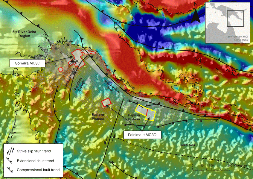
The Gulf of Papua, part of the regional Papuan Basin, is situated between the tip of Cape York (Queensland, Australia) and the eastern part of Papua New Guinea (PNG). The Aure Foreland Basin to the east and the Pandora Ridge separating the shallow shelf area of the Fly River Delta region from deeper waters with the Moresby Trough, Eastern- and Papuan Plateaus are the main structural elements established during the Paleozoic (Fig. 1). Structuration was enhanced during the opening of the Coral Sea in the Paleocene–Eocene (Jablonski et al. 2006). Seismic exploration in the Gulf of Papua has been sporadic and is intricately linked to discoveries in the area as seen by the wells and seismic acquisition density on the shallow shelf from nearshore to the Pandora Ridge in Fig. 1. Over the last two decades several 2D surveys have been acquired in the deep-water part designed to assist in the re-interpretation and understanding of the geology of the Gulf of Papua. The Painimaut multiclient data used in this study, is a broadband dual-sensor, triple-source streamer acquisition acquired in 2020 totalling 6116 km2 of coverage over parts of the Eastern- and Papuan plateaus, with a focus to cover a variety of potential plays and imaging of deeper structures. This study focussed on the Papuan Plateau (outlined in yellow in Fig. 1), an unexplored offshore area and the potential offshore extension of the play types seen onshore. As there are no wells within the study area, a sequence stratigraphic approach using mega-sequence interpretation has been used to better understand the depositional variations and their relation to major tectonic events as shown in Fig. 2.
A freeair gravity map overlain with a simplified map of the present-day tectonic setting, 2D/3D seismic acquired in the Gulf of Papua, wells, and fields/discoveries. Outlined in red and yellow are the multiclient 3D seismics available in this study with a focus on data within the yellow polygon. The map is compiled from Sandwell, Van Ufford and Cloos (2005), Struckmeyer et al. (1993), Pingram and Symonds (1993) and Bulois et al. (2018).
(a) A seismic geo-section from the Painimaut 3D dataset showing the tectonic complexity and a thick undifferentiated Mesozoic package separated into stratigraphic mega sequences. The location of the seismic line is shown on the inset map as A–A′ where A is NNE and A′ is SSW. The inset map displays a sediment isochore map between BTU (Base Tertiary Unconformity) and Basement where blue is thick, and red is thin. (b) A generalised stratigraphic chart of the Papuan Basin compiled and adapted from Struckmeyer et al. (1993), Jablonski et al. (2006), Gordon et al. (2000), Nelson (2004), and Carman (1993).
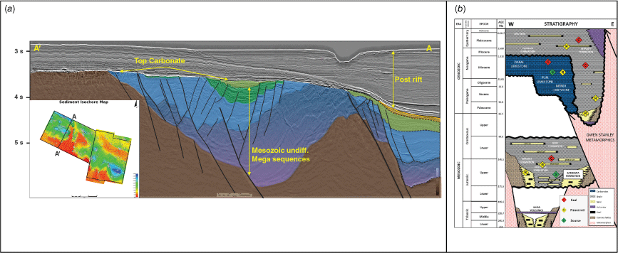
Several gas discoveries, in Miocene carbonate reefs and Pliocene clastic turbidites, have been made on the Fly River Platform proving the existence of a working Paleogene petroleum system, while the prolific onshore Mesozoic petroleum system has been elusive so far in offshore exploration. In contrast to the Fly River Platform, where Mesozoic sediments are buried beneath a very thick Paleogene sediment package, the Papuan Plateau is observed to have a thinner Paleogene overburden overlying thick undifferentiated Mesozoic to Palaeozoic sediments, which is separated by the Base Tertiary Unconformity (BTU) as shown in Fig. 2.
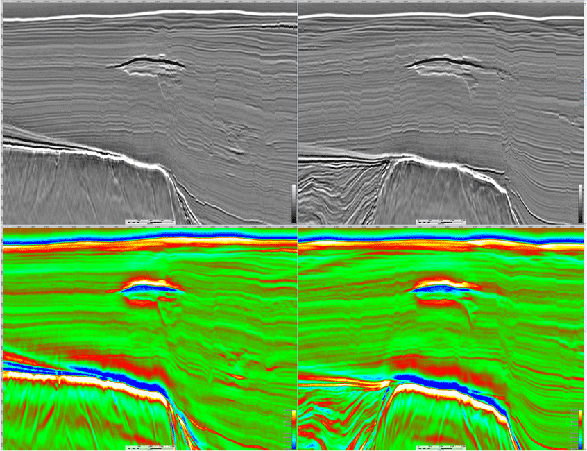
Following the processing sequence, a seismic amplitude versus offset (AVO) screening of the dataset was conducted. The AVO screening involved an inversion methodology rapidly yielding relative Acoustic Impedance, Shear Impedance and Vp/Vs Ratio volumes, which can be used in prospectivity analysis. The workflow allowed the identification of convincing AVO supported leads, particularly in the Neogene as shown in Fig. 3. It also indicates the possibility of hydrocarbon migration pathways from a deeper thermogenic source into the traps and implies evidence of a working petroleum system in the basin. This indication is based on observed seismic anomalies and their proximity to the edge of structural highs and the interpretable faults in the data which could imply a linkage to a deeper working hydrocarbon source.
Top image displays an inline/crossline view from the full stack Painimaut 3D dataset, showing a shallow seismic anomaly with a soft top and amplitude brightening. Lower image displays the relative Acoustic Impedance inversion (blue = soft and red = hard) showing a clear amplitude shut-off suggesting a possible gas-water contact (GWC).
The result of this study focusses on the exploration and hydrocarbon trapping potential of the underexplored Papuan Plateau in the southern Papuan Basin/Coral Sea region supported by seismic and shallow AVO anomalies with a potential linkage to the underlying undifferentiated Mesozoic–Paleozoic.
Data availability
The data that support this study will be shared upon reasonable request to the corresponding author.
References
Bulois C, Pubellier M, Chamot‐Rooke N, Delescluse M (2018) Successive Rifting Events in Marginal Basins: The Example of the Coral Sea Region (Papua New Guinea). Tectonics 37, 3-29.
| Crossref | Google Scholar |
Carman G (1993) Palaeogeography of the Coral Sea, Darai and Foreland Megasequences in the eastern Papuan Basin, Petroleum Exploration and Development in Papua New Guinea. In ‘Proceedings of the Second PNG Petroleum Convention’, Port Moresby, 31 May–2 June 1993. pp. 291–309. (PNG Chamber of Mines and Petroleum)
Jablonski D, Pono S, Larsen OA (2006) Prospectivity of the Deepwater Gulf of Papua and surrounds in Papua New Guinea (PNG)- a New Look at a Frontier Region. The APPEA Journal 46, 179-200.
| Crossref | Google Scholar |
Pingram CJ, Symonds PA (1993) Eastern Papuan Basin- a new model for the tectonic development, and implications for petroleum prospectivity, Petroleum Exploration and Development in Papua New Guinea. In ‘Proceedings of the Second PNG Petroleum Convention’, Port Moresby, 31 May–2 June 1993. pp. 213–231. (PNG Chamber of Mines and Petroleum)
Struckmeyer HIM, Yeung M, Pingram CJ (1993) Mesozoic to Cainozoic plate tectonic and paleogeographic evolution of the New Guinea Region, Petroleum Exploration and Development in Papua New Guinea. In ‘Proceedings of the Second PNG Petroleum Convention’, Port Moresby, 31 May–2 June 1993. pp. 261–290. (PNG Chamber of Mines and Petroleum)
Van Ufford AQ, Cloos M (2005) Cenozoic tectonics of New Guinea. AAPG Bulletin 89, 119-140.
| Crossref | Google Scholar |
Tad Choi is currently the Sales and New Ventures Manager for Asia-Pacific, PGS based in Perth. He has over 22 years of experience in the oil and gas industry, working primarily in the Asia-Pacific region. He started his career in 2002 at Woodside Energy, where he spent 10 years in Exploration then he joined PGS as a Principal Geoscientist in 2012. He holds a master’s and a PhD degree in geology from Niigata University, Japan. He is a member of PESA, EAGE, SEAPEX and AAPG. |
Jens Beenfeldt is currently a Senior Geoscientist in the Sales and Services Eurasia PGS based in Oslo. He has over 17 years of experience in the oil and gas service industry, working primarily in Europe. He started his career in 2007 at ElectroMagnetic GeoServices (EMGS), where he spent 6 years before joining PGS in 2012 as a project geoscientist. He holds a master’s degree in geology from Copenhagen University, Denmark. |
Marcin Przywara is a Senior QI Geoscientist in the Sales and Services Eurasia PGS with 15 years of experience in the oil and gas industry from both service (Geofizyka Torun, Halliburton/Landmark and PGS), and oil and gas companies (Hansa Hydrocarbons). Lead PGS Reservoir Characterisation outpost in Asia-Pacific (KL, Malaysia). Holds a master’s degree in Geophysics from AGH University of Science and Technology in Krakow. Main technical areas of expertise are Quantitative Interpretation, AVO, Rock Physics and Seismic Inversions. |