

A Merningar Bardok family’s Noongar oral history of Two Peoples Bay Nature Reserve and surrounds
Lynette Knapp A , Dion Cummings A , Shandell Cummings A , Peggy L. Fiedler B and Stephen D. Hopper C *
C *
A
B
C
Abstract
Aboriginal and Torres Strait Islander readers should be aware that this document may contain sensitive information, images or names of people who have since passed away.
Two Peoples Bay Nature Reserve on Western Australia’s south coast is world renowned for its biodiversity, particularly its threatened fauna. Future co-management of the Reserve with Aboriginal peoples is likely, although very little information on the Noongar cultural heritage of the Reserve has been published and thus available for stewardship guidance.
This study used oral history interviews on Country based on open-ended questioning and respect for intellectual property. Comprehensive surveys for Noongar cultural heritage were conducted on foot on the Reserve.
A rich trove of women’s and men’s stories from the Knapp family about Two Peoples Bay is recalled and recorded. The Reserve features prominently in Wiernyert/Dreaming stories with classical human moral dilemmas, and transformations for wrong-doing are featured. Threatened animals and important plants are named as borongur/totems. Trading of gidj/spears of Taxandria juniperina is prominent. Use of fire traditionally was circumspect, and is confined to small areas and pathways in lowlands. Granite rocks are replete with lizard traps, standing stones, and stone arrangements.
The Reserve has a long and layered oral history for Merningar Bardok Noongars, exemplified here by the Knapp family, members of which have enjoyed continuous oral history for countless generations. Granite rocks, wetlands, flora, and fauna are vitally important vessels of such knowledge.
Cultural suppression has inhibited free cross-cultural exchange of kaatidjin/knowledge until recently. As respect for culture and Elders becomes paramount, positive co-stewardship of the Reserve will become a reality. Vibrant cultural interpretation and active management by Noongar guides and rangers is recommended.
Keywords: borongur, continuous oral history, dreaming, elders, family-based cross-cultural research, granite rocks, lizard traps, OCBIL, spears, stone arrangements, totems.
Our paper begins this Special Issue on The Natural History of Two Peoples Bay Nature Reserve to provide context for the information presented herein, and so doing, we honour and respect Noongars, the Aboriginal peoples of southwest Australia. Of particular importance is that the Knapp Family, ancestors and custodians of Country – past, present, and future, have contributed generously both as authors and informants. Stewardship of Country was focused at the family level in Noongar culture, not by higher political units such as ‘tribes’ or nation-states. Noongar vocabulary is written along with the English translation as ‘Noongar/English’ to assist in cross-cultural understanding.
We begin with a précis of the ethnography of the Two Peoples Bay landscape (Fig. 1), and then progress to a discussion of significant cultural features, such as landscapes associated with the Wiernyert/Dreamtime, lizard traps, and granite rock stone arrangements. This examination concludes with a 16-part conversation illustrating the remarkable legacy of Merningar Bardok oral history. The conversation is the verbatim transcription about Two Peoples Bay Nature Reserve between Steve Hopper, one of the authors and extant members of the Knapp Family: Lynette Knapp, Dion Cummings, and Shandell Cummings. This respectful and engaging exchange reveals the rich knowledge and landscape stewardship practices of the Merningar Bardok, and bears testimony to the cultural richness of Noongar lifeways across the south coast of Western Australia.
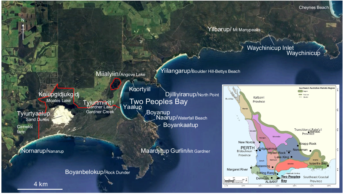
Google Earth image of Two Peoples Bay Nature Reserve (red boundary) and adjacent lands giving Merningar place names and spellings developed at an Elder-led workshop in January 2024. Inset map shows context of Two Peoples Bay and some places mentioned in the text in the Southwest Australian Floristic Region, Provinces and Districts (base map from Gioia and Hopper 2017). Camelot farm near the southwest boundary of the Reserve is where the Knapp/Cummings family lived and worked from 1982 to 1986, within a few kilometres of the traditional Knapp family camp below the Tyuirtyallup sand dunes.
Introduction
Scant attention has been paid to Aboriginal peoples and their care of Country in previous papers or anthologies of Two Peoples Bay Nature Reserve (TPBNR), even as recently as the 30+ year old draft of this special issue. The original ethnographic narrative – the discussion of cultural history and land stewardship – began in 1791, with Vancouver’s charting of the southwestern coast and naming of Mt Gardner. It represents an oversight of Aboriginal land tenure not uncommon even a few decades ago.
The Two Peoples Bay area was under active management for tens of thousands of years by Noongar people. Management was by family groups who operated under a set of lores that evolved over tens of thousands of years. These lores were handed down through generations by way of narratives passed down by Elders to those initiated to receive the knowledge and put it into practice. By the time Vancouver arrived, TPBNR was a cultural and social landscape cared for by a small group of families to provide an environment in which people could live in perpetuity and be able to pass on the same options for future generations that the current inhabitants enjoyed. Passing knowledge down through narratives/stories, the physical elements of the landscape were critical as they stood over time as landmarks to the consequences of not following lore; e.g. the story below of the star-crossed lovers and reminders in the landscape of departing from lore governing relationships.
A proper ethnographic chapter originates in the Wiernyert/Dreaming – a time far earlier than the European occupation of TPBNR. Yet a comprehensive treatment of the lives, beliefs, and ways of Noongar land stewardship at Two Peoples Bay is beyond the scope of our paper. What we offer in the remaining text is an ethnographic précis, an illustration of cultural features of the Two Peoples Bay landscape, and an engaging cross-cultural conversation among trusted friends about caring for Country.
The ethnographic record for traditional Noongar life in southwest Australia is rich for some places and Aboriginal groups, but it is strongly biased towards male interpretations and perspectives. Regardless, there are rewards in reading accounts of traditional Noongar life, e.g. in Perth by Moore (1884), and Hallam (1975), and, in Albany by Barker (1830), Nind (1831), and Collie (1832), among others. Dictionaries and collated vocabularies also deliver insights for specific places, including those written by Rooney (2011) for New Norcia and by Bussell (n.d.) and Webb (n.d.) for the Margaret River. Other examples can be found from across the southwest (von Brandenstein 1988), and across Australia (Pascoe 2014). Among the most familiar is the extensive, largely unpublished archive of Daisy Bates, who explored genealogies and broader stories across campsites from the early 1900s (Thieberger 2017). We recall several of her insights about Noongar ethnography in the following text.
An important consideration in pursuing enquiries about traditional life, however, is the recognition that so much is specific and place-based, with interpretations hinging on the extended family unit and its domain (e.g. Mokare’s domain; Ferguson 1987) rather than ‘tribes’ or nation-states. Often, early ethnographers did not attribute information obtained to specific individuals or families and tended to generalise for the Perth and Albany regions, as well as for other communities. This tendency ultimately disengaged the central importance and agency of individuals from their families, causing significant personal harm and loss of continuous oral history (Haebich 1992).
Herein, we draw attention to the need to attribute information to specific families and specific places. As we will demonstrate, there is a tremendous depth and breadth of intimate, place-based knowledge still held by some living Noongar families that is largely unrevealed to the wider public, for cogent reasons. Generations enduring the consequences of white cultural suppression keenly feel the need to hold their family information close as the single unbroken link to traditional culture central to their sense of identity and well-being. Moreover, those relatively few Noongar families that escaped the stolen generations1 (Haebich 1992) have a remarkably rich archive of continuous oral history upon which to draw.
Ethnography of Two Peoples Bay Nature Reserve
Two Peoples Bay Nature Reserve (the Reserve) and the surrounding landscape have a lean body of published ethnographical information, despite a rich trove of Noongar cultural practices overall. A comprehensive literature mostly begins around 1840, according to Daisy Bates, the Irish-born ethnographer and journalist renowned for her meticulous anthropological field work in western and southern Australia. Although Bates left an extensive set of notes and manuscripts (Thieberger 2017), we relate those most relevant to the history of the Reserve.
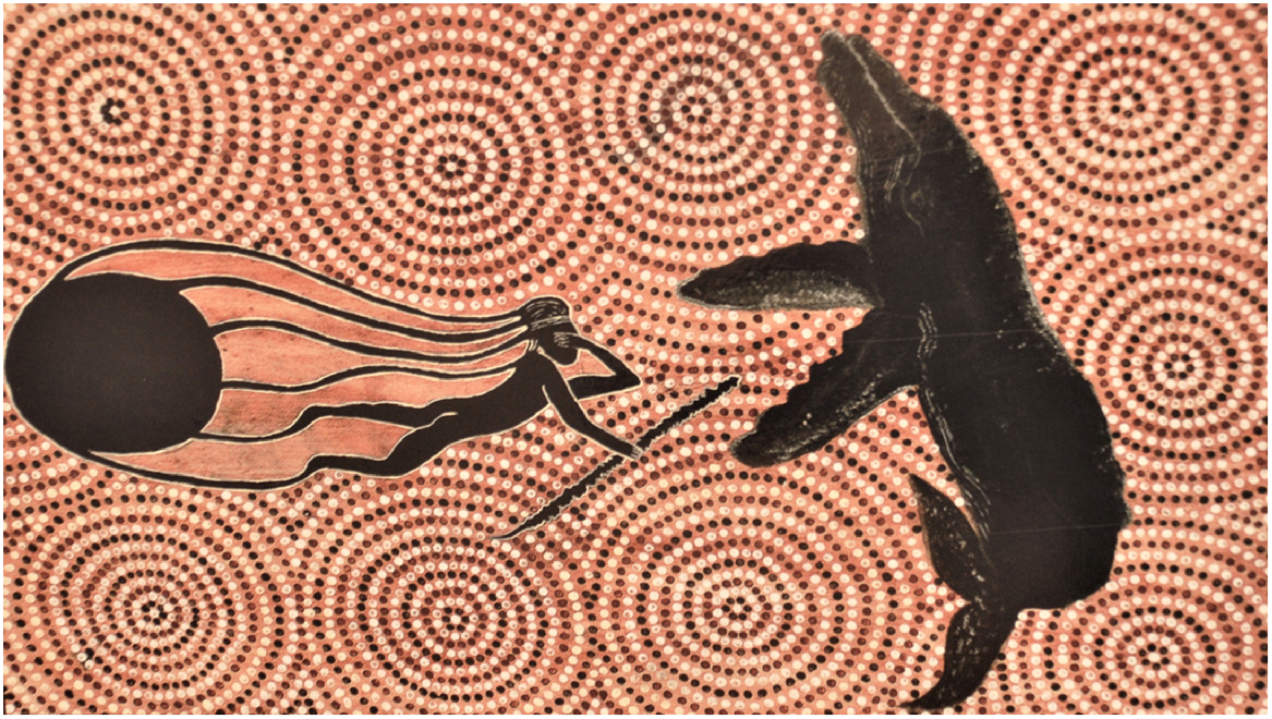
Bates interviewed a man, Nebinyan born near Albany at Oyster Harbour’s Katta burnup/Mt Martin around 1840 (Gibbs 2003). His genealogy and vocabulary recorded by Bates highlight a life spent associated with the whaling industry (Fig. 2). Hired in 1862 as a boat hand with the nydiyang/white settlers, he told his powerful stories of 15 years of whaling in song, which attracted the attention of workers including Gibbs (2003), as well as contemporary Noongar scholars and musicians such as Clint Bracknell (2017). Indeed, Noongars like Nebinyan were recruited by the whaling companies onto their crews and were rewarded equally to Europeans for their efforts (Gibbs 2003). Regrettably, Bates did not record the words of Nebinyan’s repertoire, but instead, gave a brief, melancholic account of his campfire renditions at Katanning in 1907 (Bates 1985; Gibbs 2003).
Nebinyan artwork by Shandell Cummings commissioned for the Two Peoples Bay Nature Reserve Visitor Centre. Nebinyan’s Wiernyert/Dreaming streams from his head and it is much to do with whales and whaling. Photo S. D. Hopper.
In 1837, a seasonal whaling station was established at Two Peoples Bay (Chatfield and Saunders 2024), lasting for a few years but resurrected briefly in 1873. Whaling is believed to be the European industry least disruptive to Noongar lives, compared with pastoralism and farming (Gibbs 2003). Indeed, it may have been celebrated by the Noongars, given that whale strandings provided occasional gathering points for ceremonies and week-long meat consumption from time immemorial. Because European whalers sought only baleen and oil, whale carcasses were left to the Noongars and thus used in a traditional manner. Nebinyan’s prowess afforded an opportunity to command respect as a relatively young Noongar man. This development inevitably came at a time of dramatic change to traditional lifeways, as the transition to the dominance of European settler society must have been a cause of great concern to traditional Elders. Unfortunately, the written record of the Noongar custodians of Two Peoples Bay is silent on this matter.
Bates recorded that Nebinyan’s father was Burduwan/‘maker of the burdon’ from Yilbering/Two Peoples Bay (Thieberger 2017), and his borongur/totems were wordung/raven (Corvus coronoides) and merderung/sea mullet (Mugil cephalus). His father was married to Nungilan, a woman from Yiilangarup/Yulingarup near Two Peoples Bay (Fig. 1). Her borongur/totems were manitch/white-tailed black cockatoo (Zanda latirostris) and ngwar/Western ringtail possum (Pseudocheirus occidentalis). Both parents were recorded as ‘Minang speakers’ by Bates, which is somewhat confusing, although ‘Minang’ may be an abbreviation of Merningar, meaning ‘whale people.’ Alternatively, ‘those who eat mean’ (Haemodorum spicatum) was suggested by Nind (1831). Bates’ genealogy for Nebinyan mentions that Nebinyan’s father(s) were skilled in spear construction, particularly burdon/‘heavy war spears’ (Thieberger 2017). This is an important early reference to spears and spear-making as being a special cultural focus of the Noongars of Two Peoples Bay.
Nebinyan had two consorts, only one of whom is well documented: Nguranit from Takilarap/Lake Andrew north of the Stirling Range, and Ngurakoyt, whose brothers Talarit and Tutinwer had identical places of birth and totems to Nebinyan. Two children were born from Ngurakoyt and Nebinyan’s marriage, a boy, Karalit, who inherited his father’s totems; and a girl, Kaneran, whose borongur/totems were manitch/white-tailed black cockatoo and ngamalar/chestnut-breasted shelduck (Tadorna tadornoides).
Thus, the small amount of information on Two Peoples Bay lifeways that can be gleaned from Nebinyan’s genealogy relate to spear-making, a few culturally important animals, and the sheoak tree (Allocasuarina huegeliana). Even Bates, in her two most prominent publications, cited Two Peoples Bay only in passing mention of Nebinyan’s death in 1907 (Bates 1992 but given as 1910 in Thieberger 2017) and in quoting a brief description of his whaling song (Bates 1985).
Bates wrote more about another Elder, Wandinyilmirnong, also known as Tommy King, whom she stated was born in Kinjilyilling/Albany, but who may actually have come from Two Peoples Bay (Knapp unpublished family history). Wandinyilmirnong was Lynette Knapp’s great uncle. His genealogy as recorded by Bates gives his borongur/totems as ‘Gidj (didar)’ and ‘Ngilgaitch (like a bandicoot)’. The latter most likely is Gilbert’s Potoroo (Potorous gilbertii).
An introduction to the Merningar Bardok Knapp family
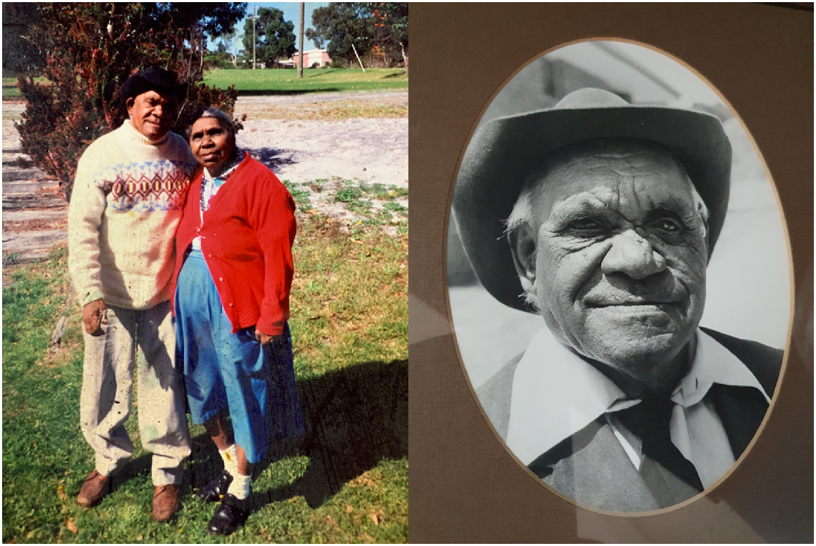
Lynette Knapp (LK, b. 19 July 1954), her daughter Shandell Cummings (SC, b. 8 March 1971), and son Dion Cummings (DC, b. 30 September 1978) belong to the Knapp Family (Appendix 2 in Arnold 2015). All three were instructed by Alf Knapp (Fig. 3), Lynette’s father, who was born in Albany in 1914. Alf was a full Noongar language speaker who enjoyed continuous oral history from his father Johnny, mother Lilian Bevan/Annie Williams, and other Noongars. LK escaped long-term placement in Gnowangerup Mission because when taken there as a child, she immediately contracted meningitis. LK was given back to her father within 2 weeks of falling ill; she remained in hospital for several months and then was nursed back to health by Alf. When she could not sleep, LK was entertained by her father around the campfire with songs and stories from her family’s long history on the south coast.
Alf Knapp with one of his sisters Bonnie Knapp, whose words and stories primarily are reflected herein as memorised by LK, DC and SC over countless yarns on Merningar Bardok Country. Many other Elders from the Knapp family and others also contributed to this remarkable body of orally transmitted katidjin (knowledge). Photographers unknown.
As Merningar Bardok people, the Knapps ranged over 800 km from Israelite Bay to Denmark, 50 km west of Albany, and as far inland as extended the northern geographic limit of the blue mallee (Eucalyptus pleurocarpa), an important botanical marker of territory for Noongars (Oldfield 1865). The family travelled regularly along their maart/paths over this extensive region, applying fire where and when appropriate, i.e. principally on lowlands and travel paths in autumn (Lullfitz et al. 2021). They kept largely to themselves and at LK’s grandfather Johnny Knapp’s insistence, only drew water from nightwells, not from open pools. Nightwells are dry in daylight but fill with water after sunset. The family had well-remembered travel routes to take advantage of such watering points.
The group of people with whom they identify are Merningar/‘whale people’ Bardoks/‘people of rough stony Country who will spear you to death.’ Merningar regard themselves also as people of the white sand, and shell people. The Bardok Noongars were mentioned in a few historical accounts as rarely encountering nydiang/white people (Dempster 1865; Helms 1896; Hassell 1975). Their geographical range broadly correlated with the distribution of the Taalyeraak (blue mallee and E. extrica) eucalypts, whose combined geographic range extends from the edge of the Nullarbor cliffs northeast of Israelite Bay, west to the Stirling Range, and extending as far inland (north) as The Lake King–Norseman Road. However, we know from their family history that Johnny Knapp travelled as far north as Hyden Rock (360 km), and as far east as Knapp Rock, west of Lake Johnston (400 km). A railway siding 50 km north of Kalgoorlie was also named Bardoc, indicating some family communication well north into the Goldfields (Fig. 1). The Merningar Bardoks had a special affinity with white sand Country on the south coast, particularly associated with dunal blowouts known as Tyiurrt yaalap or Tyirnduyalaba.2
Apart from their fearsome reputation, the Bardoks were famous for some individuals being polydactylous, with six fingers and six toes on their limbs (Helms 1896; Hassell 1975). This genetic attribute is still evident today in the extended family. Such an unusual physical trait added to the Knapp family’s reputation as being enspirited people with six-toed footprints.
Because of their elusive and sometimes secretive nature, the Merningar Bardoks were not mapped by Tindale (1974) as a distinct dialect group of Noongars. Yet contemporary linguistic studies highlight several words and phrases that are uniquely Bardok (Knapp and Yorkshire 2022). Some have been incorporated into placenames, such as the Bardok word ‘yeel’ for hill rather than ‘kaat’ used by Menang people. Yilberup is the traditional name for Mt Manypeaks (Fig. 1), which means ‘the rough and rocky hill’ (Table 1). The word Noongar itself is a Bardok word for a warrior who has gone through two sets of law – desert and coastal (von Brandenstein 1988). Hence strictly speaking, women cannot be Noongar warriors. It seems ironic that ‘Noongar’ has been widely adopted in recent times as the name for the Nation that extends from Yued Country in the northwest to Bardok Country beyond Israelite Bay. LK says she is not a Noongar but a Bibbulmun, another Bardok word for the Nation also advocated for by Bates (1992). The Knapp’s Bardok language was written down by Bates when she interviewed Lynette’s great grandmother, Jakbam, with one of her husbands, Wobinyet, in the early 1900s (Thieberger 2017).
| Place name | Existing name | Derivation | Translation | |
|---|---|---|---|---|
| Boyanbelokup | Rock Dunder | Boyan = orphan; belok = ankle | Boyankaatup’s ankle, where he tripped forward and turned into a shark after being hit in the back by the No. 7 boomerangA | |
| Boyankaatup | Hilltop south-west above Little Beach | Boyan = orphan; kaat = hill, head | Stone head of the orphan of the first of the Seven Sisters turned to stone | |
| Boyanup | Tidal pool | Boyan = orphan | Place of the orphans | |
| Djilliyiranup | North Point | Djilli = wing tip, yir = upturned, an = kept; | White-breasted Sea Eagle (Icthyophaga leucogaster) place, signifying men’s law ground | |
| Kaiupgidjukgidj | Moates Lagoon | Kaiup = water, gidj = spear, uk = for, on, to, gidj = spear | Lake with an abundance of gidj (Taxandria juniperina) for making spears | |
| Koortyill | Unnamed red hill adjacent Herring Bay at the north end of Two Peoples Bay | Koort = heart, yill = hill | Hill where Tandara placed her broken heart after seeing her baby die at the hand of Yilberup | |
| Maardjitup Gurlin | Mount Gardner | Maardjit = white-pointer shark; gurlin = movement, no. 7 kylie/boomerang | Place of Boyankaatup in the form of a white-pointer shark, moving, with the dorsal fin the No. 7 boomerang thrown by Yilberup | |
| Miialyiin | Angove lake | Miial = eyes; yinn = tears | Tears of Tandara grieving for her baby | |
| Naarup | Waterfall Bay | Naar = edge of cupped hand, edge of bay | Place for drinking freshwater with cupped hands by the ocean | |
| Nornarup | Nanarup | Norn = black snake; arup = become | Place where black snakes thrive | |
| Tyiurrtmiirity | Gardner Lake - Angove Lake wetlands | Tyiurrt = spirit man, ancestral being of the southern coast, sandy blondy; miirity = water snake | Giant spirit snake place | |
| Tyiurrtyaalup | Moates dunes | Tyiurrt = sandy spirit man, ancestral being of the southern coast, sandy, blondy; yaal = sand | Enspirited dunes where people camped to trade for spears, and where Boyankaatup stood throwing rocks north at Yilberup across Two Peoples Bay | |
| Yaalup | South Point | Yaal = sand, grave | Place of graves dug in sand | |
| Yiilangarup | Boulder Hill, Bettys Bay | Yiil = hill, an = kept, gar = people of | Place of the people of the hills | |
| Yilberup | Mount Manypeaks | Yiil = hill, bar = rough, stony | Rough hill of stones. Also place where the stars fell to the ground when the dark emu was flung up into the sky. Place of ancestral bordier/boss Djimaalap’s son. | |
| Waychinicup, Waichinicap | Waychinicup estuary, inlet | Waitch = emu; tyianaq = little foot, ghost, spirit; up = place of | Place where the Wiernyert/Dreamtime emu stepped when being chased by the black magic snake from Alice Springs to Albany, or river that puts Emus into being (von Brandenstein 1988 pg 150) |
The use of Tyiurrt is not without precedent, e.g. Tyiurrtgellong for Lake Seppings at Albany; Mt Chudalup = tyiurrtilup south of Northcliff. Similarly, Boyanup has been used for orphan place on the southern Swan Coastal Plain. Derivation and translations from Knapp family oral history, Jakbam’s vocabulary and Nebinyan’s geneology (von Brandenstein 1988; Thieberger 2017).
Merningar Bardok Tales of Two Peoples Bay Nature Reserve
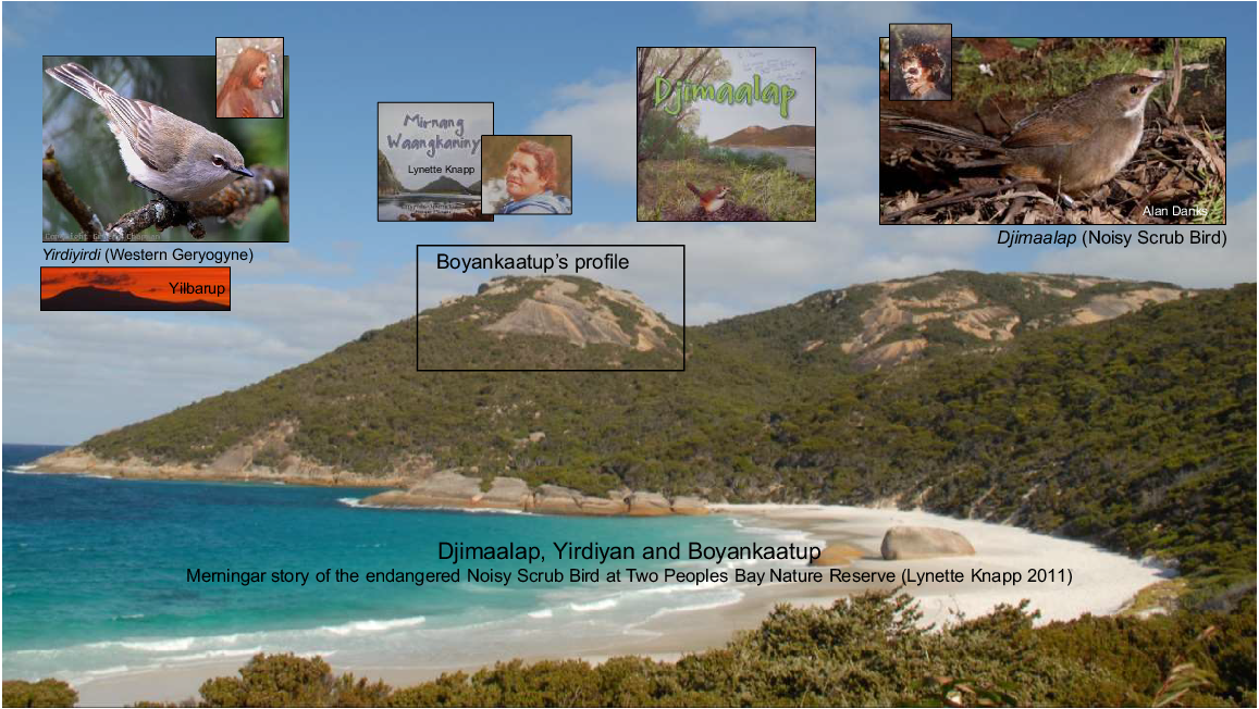
Two short tales from the published Knapp family stories (Knapp 2011) illustrate that TPBNR is clearly part of traditional Merningar Bardok Country. First, Djimaalap is the ‘sad story of two young people from the same tribe who were madly in love with each other, and what happened to them when they disobeyed the Elders. Djimaalap and Yirdiyan were two young lovers who could never marry because it was forbidden’ (Knapp 2011, p. 3). When trying to elope with the help from Djimaalap’s friend, Boykaatap3 as a lookout, the young lovers were discovered by the Elders. Boyankaatup was turned into stone forever looking across the bay to Yilberup/Mt Manypeaks (Fig. 1). Yirdiyan was turned into a little bird, the Western gerygone (Gerygone fusca), which is the Knapp family’s animal borongur/totem. Djimaalup became the noisy scrub-bird (Atrichornis clamosus) (Fig. 4) forever calling out to his beloved Yirdiyan. This story is told in depth in the oral transcriptions later in the paper.
Country speaks at Little Beach, Two Peoples Bay Nature Reserve. A prohibited elopement of Djimaalap and Yirdiyan sealed their fate as humans transformed into birds, with the orphan lookout Boyankaatup forever turned to stone looking north at Yilbarup/Mt Manypeaks. Landscape photos S. D. Hopper. Birds Graeme Chapman, Alan Danks. Other images from Knapp (2011).
A second story, Margit wer Barmba/shark and stingray, is a men’s tale about two brothers who fought over a young woman. One brother was good at throwing gidj/spears and the other, a kylie/boomerang. The Elders, tired of the brothers squabbling, sent them to The Gap in today’s Torndirrup National Park south of Albany. Each stood on one side of The Gap and together they threw their weapons at the other brother; each hit their mark. Falling into the water, the brother hit by the kylie/boomerang turned into a shark, and the other, a stingray. As will become evident below, this story is foundational to an understanding of the origins of TPBNR. Again, this tale is featured in the oral transcriptions.
Most activities of traditional everyday life, including the use of small-scale cool burning of camps and tracks, were conducted low in the landscape near beeliar/fresh water sources and good hunting and gathering grounds. For example, we feature for the first time in the transcripts below a form of aquaculture practised to foster the growth of edible freshwater mussels (Westralunio inbisi) in TPBNR.
Uplands, particularly granite rocks, were only for day use and usually special ceremonial occasions, with various access restrictions depending upon age and gender (Lullfitz et al. 2021; Cramp et al. 2022; Rodrigues et al. 2022). In many ways this perspective on differential land use developed by Noongars over thousands of generations is reflected in the independently derived theory of old, climatically buffered infertile landscapes (OCBILs; Hopper 2009, 2018, 2023). Once this overlap in world views was realised, strong collaboration developed between the Knapp family and conservation biologists based at The University of Western Australia’s (UWA) Albany campus and elsewhere, as recognised by Hopper and colleagues (2016, 2021; Hopper 2023), Lullfitz et al. (2017), Silveira et al. (2021), and exemplified in the present paper.
LK and the extended Knapp family have increasingly shared and celebrated their culture through various activities, including publications (Lullfitz et al. 2020, 2021, 2023a; Knapp and Yorkshire 2022) and modern electronic newsletters such as The Conversation (Lullfitz et al. 2023b). LK is now an Adjunct Elder/Research Associate with the University of Western Australia’s Albany campus and plays an active role in teaching and co-supervising advanced degree students working in conservation biology and ethnobiology (e.g. Cramp et al. 2022; Rodrigues et al. 2022).
Merningar Cultural Legacy at Two Peoples Bay Nature Reserve: lizard traps and stone arrangements on granites of the reserve
Not surprisingly, the oldest signs of ancestral practice on TPBNR and elsewhere are in the oldest parts of the landscape that persist for the longest time; the granite outcrops. Lizard traps, for example, are to be found everywhere vehicular access is difficult and is distant from nydiyang/white people’s trails (Cramp et al. 2022; Fig. 5). These simple rock constructions of a rock slab propped up (‘coverstones’) provided shelter and habitat for lizards and snakes, but also served to create lizard hunting sites for Noongars. Mining of these coverstones was widely practised using stone axes and fire to crack thin slabs orthogonally (Fig. 6). Other common stone structures erected by ancestors include standing stones, and stone arrangements (Fig. 7). Certain configurations of standing stones are known to be markers warning women and uninitiated children not to go further. The significance of other stone arrangements is sacred knowledge and not to be widely shared. Moreover, large stone structures such as the summit of Maardjitup Gurlin/Mt Gardner often relate to Wiernyert/Dreaming or astral connections. In short, the entire eastern inselberg of the Reserve is replete with special cultural sites on granite.
Lizard traps are common on the upper slopes of Maardjitup Gurlin/Mt Gardner. They consist of a flatrock averaging approximately 1 m square, held above the bed rock at one end by one or more propstones. This creates a dark space opposite the propstone which lizards and snakes retreat to when threatened. Susie Cramp and Larice Guislain in centre photo for scale. Photos S. D. Hopper.
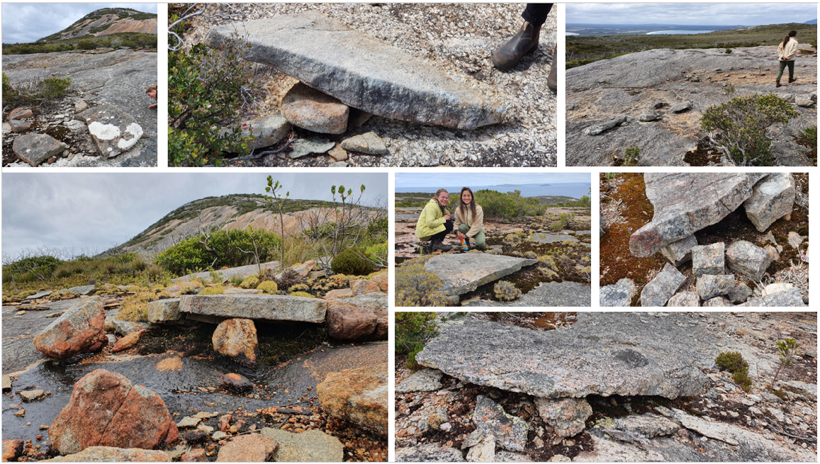
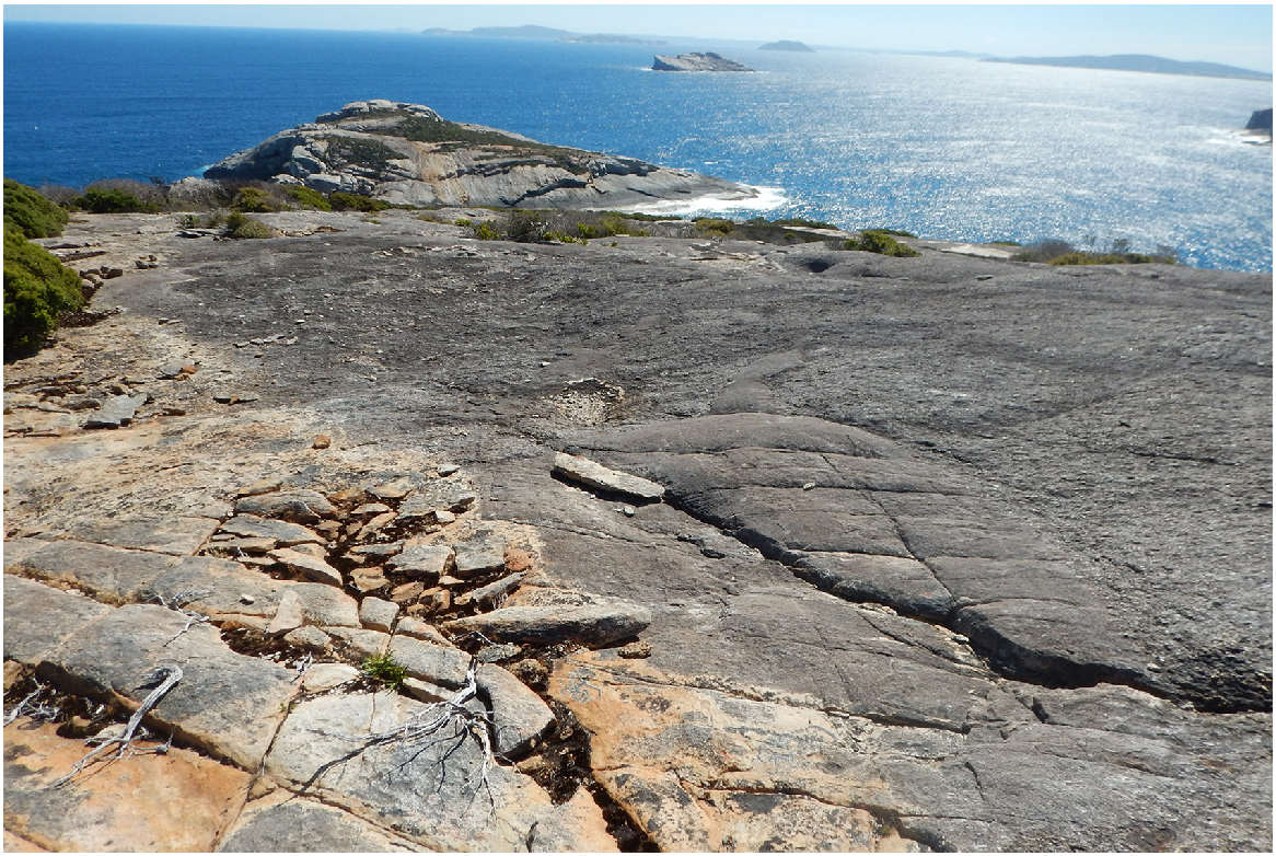
Mine for lizard trap top slabs. A thin sheet of exfoliating granite is chosen to chip away orthogonal squares to which fire is applied along the joins (the orange colour of the rock indicates it has been burnt). This weakens the granite and enables slabs to be prised off the bedrock. Note the finer texture of the mined apalite, as distinct from the rougher-surfaced granite rock with bigger crystals adjacent. Cape Vancouver looking south-southwest, with Boyanbelokup/Rock Dunder in the midground and Breaksea Island on the horizon. Photo S. D. Hopper.
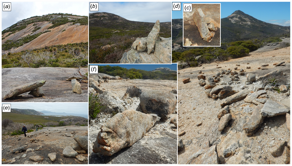
Various stone arrangements not due to natural causes that have been created by Noongars west and south of Maardjitup Gurlin/Mt Gardner including: (a) Lizard trap adjacent a standing stone pointing to the summit; (b) another standing stone propped up atop a tor and pointing east past the summit; (c) standing stone; (d) complex quartz mine with lizard traps, standing stones and arranged small boulders; (e) lizard trap and circular stone arrangement; and (f) standing stone with face engraved at one end on seal-shape pointing to Boyanbelokup/Rock Dunder. Photos S. D. Hopper.
The bare dunes near Kaiupgidjukgidj/Moates Lagoon similarly is an entire landform of significance as it served as a major trading centre connected to the Wiernyert/Dreaming where Boyankaatup threw rocks at Yilberup (see transcripts below). Within the dunes are countless archaeological sites that are exposed then reburied as the sand shifts with the wind. A much more generous concept of Aboriginal ‘special site’ is needed if the full gamut of Noongar spirituality and daily life are to be respected.
Discussion
The remarkable body of Merningar Bardok oral history, as retold in the following text and published here for the first time, bears testimony to the cultural richness of Noongar lifeways across the south coast of Western Australia. Specifically, regarding TPBNR and environs, there is now a perceptive and insightful account of landscapes managed by Noongars for tens of thousands of years.
There is an elegance and rhythm to the stories revealed herein. They are and were spoken in plain language, and they are easily remembered; although some of their richness is lost in the written word. There is something moving and powerful witnessing their telling on Country that the associated video archive held by UWA highlights. Of course, much has been lost or cannot be told in this format; the songs, specific dances, secret rock art, and the special knowledge of people, plants, animals, and places. The stories were filtered by Alf Knapp and other Elders as recited to LK, DC, and SC, and they have been filtered again by the authors of this paper. Aspects of secret men’s and women’s business, and age-related controls over conveyed knowledge were and are managed carefully. Yet sufficient cultural heritage has been transmitted into the public domain here to enliven understanding of the cultural importance of the Reserve to all who live today and for the descendants of the Knapp family and others. Agency and respect have been restored to the Noongar intellectual property holders of the Knapp family as best as possible in this process.
Some of the layering of Noongar stories emerges from a reading of the Knapp family oral history. There are countless perspectives on each tale, depending upon who the storyteller is, who the receivers of the story are, and where in the landscape the storytellers and receivers are positioned. Yet central themes concerning the Wiernyert/Dreaming and creation of landscapes and lifeways emerge repeatedly.
Most stories of landscape and ancestral characters have a clear moral to them. Djimaalap and Yirdiyan disobeyed the Elders in trying to elope, so as punishment they were turned into birds (Fig. 4). Boyankaatup tried to help the planned elopement as a lookout and is forever now looking across at Yilberup/Mt Manypeaks as punishment for the transgression of traditional law. Boyankaatup and Yilberup committed the cardinal sin of brothers fighting over their sister as a marriage partner and were turned into marine animals before being locked into stone after their great fight.
A legacy of the Knapp’s oral history is the potential to adopt Noongar place names within and adjacent to the Reserve. Fig. 1 was derived in a family workshop with suggestions that make sense in terms of many of the stories told herein (Table 1). Something would be lost in translation if these were adopted under the belief that there is only a single placename for each feature in Noongar culture. Every family has its own stories and they differ within and among families depending upon context and historical interpretation. It is important to remember this and appreciate the diversity as collective truths. We should not be worried by the lack of agreement on specific details nor language used. That is part of the richness of the culture, as are the general themes that emerge and provide the overarching superstructure to the layers of tales beneath.
Faunal persistence and the megafauna
The great biological success of TPBNR and surrounds has been the assisted persistence of endangered animals rendered extinct elsewhere across their original ranges. Noongars would argue that the persistence of animals such as the Djimaalap/noisy scrub-bird and Nilgaitch/Gilbert’s potoroo is because they have continued to be celebrated through oral history right up to the present day. Their stories and key roles in Wiernyert/Dreaming events, as well as use as borongur/totems have been fundamental to keeping them alive and healthy. Nydiyang/white people’s efforts have also contributed materially to the care of these endangered species in recent decades (e.g. Danks 1997). The Reserve sits on the south-eastern edge of the high rainfall heavily forested Country of the south-west. Yet it has been managed thoughtfully in a different way with regards to the use of fire than today’s approach to prescribed burning based on aerial ignition (Bradshaw et al. 2018).
The deliberate exclusion of prescribed burning from Maardjitup Gurlin/Mt Gardner is replaced by the use of a wide slashed firebreak across the isthmus of the peninsula on the Reserve. We also know through the Knapp family oral history interviews below that Two Peoples Bay Noongars as well as their northern neighbours from Yillangarup/Boulder Hill performed ceremonies to call up the giant snakes of Tyiurrtmiirity/Gardner Lake, Gardner Creek, and Miialyiin/Angove Lake. That the Tyiurrtmiirity were revered and respected culturally cannot be denied. They had their own Wiernyert/Dreaming stories, considered so important that Alf Knapp taught his grandson (DC) their essential content in modern times. The Knapp family also recounts very large snakes associated with Tyiurrtmiirity/Gardner Lake, Gardner Creek, and Angove Lake. DC’s description of the dimensions of the snake 5 m long with a big head he once observed with his father four decades ago intriguingly may match those of the fossil species of snake, Wonambi naracoortensis (Palci et al. 2018). Careful study of these fossil snakes suggests that they may have been semiaquatic as well as subfossorial, and they persisted right up to the late Pleistocene in habitats that were cooler and drier than those favoured by a sister genus that went extinct much earlier (Palci et al. 2018). Wonambi fossils have been recovered from Mammoth Cave and Koala Cave on the Leeuwin Naturaliste Ridge south of Margaret River (Scanlon 1995).
Intriguingly, as recorded in a 19th century whaling journal, a harpoonist wrote:
… After breakfast (in December 1849) one boat was lowered in which some shovels and buckets were put, and manned by six men with an officer in charge… and went onshore to clear out a spring of water, and get it ready for taking onboard some 100 or more barrels.
By noon the boat returned reporting the spring clear of mud and weeds but the water would not be fit to put into the casks until next day. The officer reported that on their arrival at the spring, and commencing to cut away the vegetation that had grown around it, a terrible crashing of brush and shrubs was heard, accompanied by loud hissing sounding like escaping steam from a small engine. They all beat a hasty advance backwards, dropping shovels and hatchets…. After getting out on the beach, they saw an immense snake crawling slowly up a slight hill, now and then rearing his head four or five feet above the ground, turning his head from side to side with his large mouth wide open. He said no doubt the snake was not more than twenty or thirty feet long, but it did look like it was a hundred, and seemed in no great hurry to move on. They went back on tiptoes, and worked for a while without touching their heels to the ground, so he said. This bay is named Two Peoples … (Haley 1849–1853, 2013)
Place naming using Merningar Bardok language
There are place names in and around TPBNR that are so clearly powerful that they have persisted to the present day, either through the ethnographic record, oral history or both; Boyankaatup and Yilberup/Mt Manypeaks are two examples (Fig. 1). Here, we aim to enlarge the available Noongar place names in Merningar Bardok based on the rich oral history given below, and the equally rich language resources that persist through oral transmission and the vocabulary of Knapp’s great grandmother, Jakbam, and great uncle, Wandinyilmirnong (Tommy King), as recorded by Bates in the early 1900s (Thieberger 2017). Also, von Brandenstein’s (1988)Nyungar Anew records useful information on the Merningar Bardok language. Using these resources the language will continue, establishing an ongoing respectful connection to the ancestors who were one with the Reserve over countless generations.
Our investigations as to apposite Merningar place names are given in Fig. 1, and in Table 1. We hope that these will be taken up by others.
OCBIL theory hypotheses concerning cross-cultural issues
This study has obtained evidence that supports cross-cultural hypotheses of OCBIL theory. The latest formulation of the theory (Hopper 2023) has three specific hypotheses on cross-cultural matters: (1) First Nations revere sacred uplands; (2) minimise human disturbance of OCBILs; and (3) conserve biodiversity through cross-cultural stewardship. Rational reverence (Laudine 1991) of OCBILs is evident for Maardjitup Gurlin/Mt Gardner. This is seen in the fundamental Wiernyert/Dreaming story involving the fight between Boyankaatup and Yilberup told below. Moreover, other layers of stories for women or initiated men pertain to specific places on Maardjitup Gurlin/Mt Gardner, and revealed in the Djimaalup/Yiridiyan elopement story, and the floating rock near Naarup/Waterfall Beach for men’s business associated with calling up sharks and whales.
Minimising disturbance is also evident for the OCBIL granites of Maardjitup Gurlin/Mt Gardner, notably the predominant absence of the use of fire for countless generations but for mining activities associated with lizard trap construction (Cramp et al. 2022). Conserving cross-culturally may be achieved in many ways in future management of Two Peoples Bay Nature Reserve.
Future management to celebrate and actively involve Merningar Bardok cultural custodians
A way to ensure healthy Country and cultural connections is to involve Noongar Elders and multigenerational family participation in the ongoing management of the land in partnership with contemporary land owners. The fundamental importance of TPBNR as a source of gidj/Taxandria juniperina for spears, for example, encourages us to recommend that places are selected on or near the Reserve where gidj/Taxandria juniperina swamps are managed to retain a succession of slender, straight, regrowth suitable for spear construction. Such sites could be interpreted liberally through appropriate information signs, but most importantly, by the engagement of Noongar guides and rangers, coupled with regular demonstrations of spear making on site. To establish such a program, an Elder-led approach would be essential and could be achieved through agreed cross-cultural collaboration with land managers under the auspices of a Healthy Country Plan developed by Noongars.
The importance of Noongar guides telling their own stories on Country cannot be over-emphasised. This is a powerful demonstration of respect for culture and intellectual property holders, as well as shared commitment to cross-cultural collaboration. Cross-cultural conservation with active participation and leadership from First Nations is a key hypothesis developed to care for old, climatically buffered, infertile landscapes (OCBILs) such as seen on TPBNR’s Maardjitup Gurlin/Mt Gardner (Hopper 2023; Hopper et al. 2024). We see a bright future for the Reserve and its surrounds if this path is followed.
Conversations about caring for Country
We conclude this chapter on the cultural context of TPBNR with rare narrative by the Knapp family. In conversation with SDH, LK, DC, and SC provide a deep, intimate perspective across the time and space of the Reserve. Sixteen oral vignettes shared among friends, in a spirit of friendship and deep respect, illustrate the rich, rewarding collaboration, and crucially important cross-cultural caring for Country.
The oral history accounts that follow are based on transcribed video recordings on Country that were undertaken under the University of Western Australia’s (UWA) Human Ethics Approval RA/4/1/6836. Such approval is based on the principles of prior informed consent, respecting Noongar participants as intellectual property holders, and ensuring open-ended questions with no pressure to answer any particular way. Thus, all video recordings, photographs, and transcriptions belong exclusively to the Knapp family. The family holds the copyright and gives ultimate approval (or not) to publish or otherwise share the information recorded upon request.
As to the veracity of the Knapp family’s oral history, a number of checks rendered them highly credible. Firstly, coming from an oral history cultural tradition, LK and her two children, DC and SC, display remarkably consistent recall. Their memories are formidable. Moreover, ensuring that the sequence and detail is accurate, every telling is vital in First Nations’ oral traditions, as survival often depended upon it. Stories told two decades ago to other recorders such as Goode et al. (2005) were delivered verbatim or nearly so when recorded for this and other projects. Such internal consistency was also reflected in shared consistency among family members.
The recollections of places never visited by the story-teller, but conveyed to her by Elders of the family in the past were another check for consistency among participants. Several times on Country LK would say, ‘I recognise this place’, and before arrival accurately describe what we were about to see. Thirdly, stories told by other Noongar families would contain elements of what the Knapps had conveyed orally, details that not always, but sufficiently often, were recounted to deliver a sense of a shared oral history tradition across Noongar families (e.g. Lullfitz et al. 2021; Rodrigues et al. 2022).
Lastly, some have suggested that LK couldn’t know about a site that was for men’s business only (Goode et al. 2005). Although LK was fastidious in referring such matters to her sons or other males in the family, her father shared many things privately with her around countless campfires that were not for public ears. She has knowledge broader than most women because of her close connection to her father, stemming in large part from when he was nursing her recovery from meningitis contracted when she was taken from her family as a child.
First contact between LK, DC and SC and SDH occurred in February 2013 on a survey of the cultural heritage of Quaranup Peninsula south of Albany (Mitchell 2013). After several years of gradually getting to know each other and building trust, it was agreed that LK’s oral history would be recorded for the family records by SDH and his team at UWA. SC and DC subsequently agreed to participate.
Visits to TPBNR occurred in the context of far-ranging trips between Israelite Bay and Denmark on the south coast on traditional Merningar Bardok lands and waters. On the Reserve, LK and DC chose where to stop and conduct interviews at places at which they felt comfortable sharing and recording stories. This method often prompted memories that otherwise would not have come to mind.
SDH visited the Reserve many times between 1973 and 2024 as a research biologist working mainly on plant life and pollination biology, as well as the ecology of granite outcrops (Hopper et al. 2024). Extensive surveys of the Reserve occurred on foot, by vehicle, and in canoes. Particularly since the November 2015 wildfire on Maardjitup Gurlin/Mt Gardner, evidence of Noongar cultural heritage, including the presence of lizard traps (Cramp et al. 2022), standing stones and stone arrangements, were recorded photographically (Figs 5, 6 and 7) and in notebooks.
Following are verbatim transcripts of oral history discussions among LK, DC, SC, and SDH that elucidate aspects of the Reserve and traditional lifeways practised thereon. They are given verbatim to ensure the words of LK and DC and their sequencing are authentically reported. Essentially their form and structure follow Alf Knapp’s and other Elders’ rendition of the family’s oral history going back countless generations.
Merningar place names (Fig. 1, Table 1) were decided at a workshop on 16 January 2024 involving LK, DC, SC and SDH, and videotaped subsequently (5 March 2024) on the Reserve. The objective was to ensure reconnection with ancestors through the use of Merningar language as conveyed to the authors by family members, and thus to associate names with the oral history stories reported below. This process brought forward memories of past discussions with Alf Knapp and other family members. For example, when the name, Kaiupgidjukgidj, emerged for Moates Lagoon after LK had read von Brandenstein’s (1988) account of disputed waterholes near Israelite Bay, she then recalled her father using Kaiupgidjukgidj to refer to Moates Lagoon. It is perfectly apposite, translated as ‘water spear on spear’, as the Lagoon is surrounded by gidj/Taxandria lanceolata forests, the prime source of wood for spears. Here we use Merningar place names first to respect cultural and temporal priority and continue to include the English place name following a forward slash or in parentheses whenever known.
Part 1. Traditional Knapp camp on Two Peoples Bay Nature Reserve and Nornarup/Nanarup – Lynette Knapp and Stephen Hopper. 16 January 2024
| SH: | Lynette we’ve just finished identifying place names in Two Peoples Bay Nature Reserve and you have a very important family campsite to mention. Could you tell us a bit about where it was and who told you about it? |
| LK: | I used to live at Nanarup on a farm (Camelot), the closest farm to the water, and I often had Aunty Bonnie down (Fig. 3). She used to come and stay with us. She and I walked all the way through the bush (to the east). She knew it very well. She used to say how they used to burn through there and it was like parkland. She also used to say they had a camp over between the sand, the white sand (Tyiurrtyaalup) and the ocean. That’s the camp that you’ve got marked (on the screen, Google Earth). It’s funny to me because we used to also walk along the beach and come out opposite that and sit on a cliff front and watch the dolphins. She was a very fit old lady. I used to crawl under the fences and Aunty Bonnie jumped the fences! She jumped the fences with a 22-rifle on her back, after rabbits. We used to go over there and she used to talk nonstop. I guess coming back at different times helped to reconnect her with the Country that she was used to. The Country that they had those Noongar names for. |
| SH: | So when are we talking? How old were you when they were camped there? |
| LK: | Oh Dion was about four. |
| SH: | Dion you’re 45 now right? So 40 years ago. Early 1980s. |
| LK: | 1984 I believe, because I lost my sister in ’84. |
| SH: | And how long would they camp there at that spot? |
| LK: | Oh they’d possibly camp to rest up. Find some muringe or tucker or food. And rest up for a while. Do some hunting. Just go along fishing. My grandfather was a great fisherman. He used to be able to time the salmon (Arripis trutta) fishing season at most of these spots and this was one of them. When he saw the salmon he used to call the dolphins in. He was a dolphin man. Dolphins used to look after him when he was swimming. And he called the dolphins in by standing waist-deep in water slapping the water and the dolphins used to push all the salmon up on to the beach. So he more or less would have fed that full camp if he was around. And he was a young bloke when all the traditional black fellas was camped out there. |
| SH: | What sort of murring/food ‘tucker’ can you recall eating there apart from fish? |
| LK: | Oh well marron was called murring. They twisted that around and called, from our food word marron (Cherax tenuimanus). The old murring (became) marron. Imagine living on marron! Fish. Just over from that camping area there’s a beautiful bit of salt water full of bream (Acanthopagrus spp.), so in them days you’d catch them on anything. |
| SH: | That was the estuary at Nanarup you’re talking about? |
| LK: | At Nanarup or Nornarup (Fig. 1). Nanarup is today’s word for it but it’s Nornarup – place of black snakes. And there’s lots of pythons there. My family lived off them. We used to eat ‘em. And of course the paandee (Acanthopagrus australis), what we call bream, that’s really paandee, that was prolific. |
| SH: | And plant life, can you recall what you would eat at that particular camp. |
| LK: | Oh there was kooding (Haemodorum discolor), Cummuck (Billardiera heterophylla). Lots of stuff. |
| SH: | Wattle seed I suppose – Acacia cyclops? |
| LK: | Wattle seed yes. Everywhere out there. That was one of the main staple diets of bashing it in with fish to make little fish cakes. |
| SH: | Great. Anything else you can remember about the place of significance? |
| LK: | Oh it’s highly significant. It was especially nice walking through the bush with Aunty Bonnie listening to all her yarns. Amazing. |
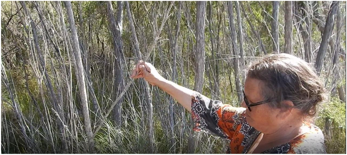
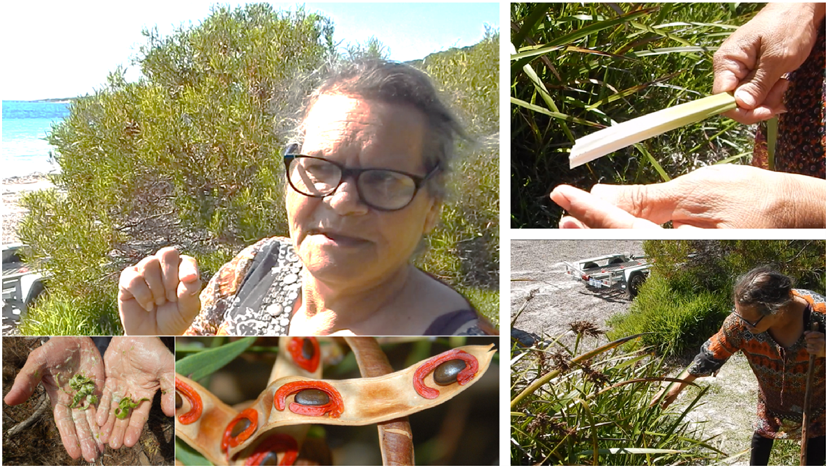
Part 2. Gidj – Lynette Knapp and Stephen Hopper yarning about spears on Two Peoples Bay Road. 10 April 2017
| SH: | We’re in Two People’s Bay still, just near the crossing of Two Peoples Bay Road over Tyiurrtmiirity/Gardner Creek. And Lynette has a very special plant to talk about here. |
| LK: | I would like to take this opportunity to tell you that around, in the Two People’s Bay area, or particularly over near a lake to the west of here (Kaiupgidjukgidj/Moates Lagoon), which isn’t far off, there’s a special sand dune area that we’ll pull up and have a look at when we go past there. And it was a place where people from other countries, their countries, would come into here, be allowed to stay here, and do trade. And the trade in this area was because the Gidj, this is the Noongar name for spear down here, or Mirningar name for spear down here. And they were farmed from this tree. I don’t know the botanical name for it, but we call it Gidj. |
| SH: | Gidj. So this is Taxandria juniperina. |
| LK: | Lovely. And if they, when they grow like this, but in a thicker denser area, you’ll get a lot of spear sticks out of here. And that, spear sticks weren’t really big either. They were small, almost you know… |
| SH: | What sort of size Lynette? Can you tell or show us? |
| LK: | See this one? See this one? (Fig. 8) This would be the size, but it would… they’d look for things that would be longer than this. |
| SH: | That’s quite thin eh? |
| LK: | Yeah it’s very thin. And that would be the proper stick, spear stick. You see spears made out of stuff like this, but it’s not the right way of doing it. These are the sizes of all these, the spear sticks that were collected from down here. And it was a big trade. It was a huge trade in traditional times. |
| SH: | Did you ever see your grandfather or father make a spear out of this? |
| LK: | Yeah! |
| SH: | Can you describe what they did? |
| LK: | Especially when we were around the fresh swamp areas that were where we travelled and lived around, and out this way. They’d come and collect, but the spear sticks would be a lot taller than this, they’d be like seven foot something. But that’s what they’d look for. The size of that. |
| SH: | And to make a spear what was the process? |
| LK: | Oh they’d cut it down and take it back to their camp fires. Skin ‘em, I mean put them in the fire and skin them at the same time. And the fire, the heat would take out all the little bends, such as this. They’d bang them into place. But most times these ones grew up tall and tall and healthy and long. |
| SH: | So not much time really to convert that into a spear by the looks? It’s pretty straight. |
| LK: | This one’s pretty straight, I’ll let it go. See it’s gonna grow pretty straight. |
| SH: | Yes. |
| LK: | But then we come into the times now, where you can only find these growing by the roadside. They would have put a road right through a great big growth of these trees. And when it’s thicker, it grows, these tend to grow higher. Reaching for the light, especially if they’re thick and dark inside then they grow higher for the light. And they’d be farmed (Pascoe 2014) and used in the trades. Black fellas had big trades in this area. And this is pretty famous for all those trades. |
| SH: | Can you describe the farming? What do you mean by that? |
| LK: | Oh people coming looking for the spears and taking them out. They’d probably look through this little grove here and leave it because I can’t see very many that would of any use unless the ones that I just picked up then grow a bit taller. |
| SH: | Would they use fire to keep them at the right growth stage? |
| LK: | With this, with this stuff the fires, the farm, fire farming that they did way back when, they’d probably all be burnt through but if they could avoid, because they needed that dark area to grow up, they… More often than not fires went through and cleaned them all out. But it probably, with the spindly one, it’d do more damage than anything else to burn them. |
| SH: | Yeah. So they’d actually protect these from fire? |
| LK: | Yes. And because this only grows in fresh water. A lot of our trees that we use are all freshwater trees. They grow only in freshwater and don’t like salt. The paperbark, the paperbark tree is, I think it’s a family of the paper bark tree, or very similar, paperbark tree |
| SH: | That’s a Melaleuca, this is a Taxandria, but they both are in the same family. |
| LK: | Is it? Oh! |
| SH: | The Eucalypt family. |
| LK: | Oh OK! |
| SH: | With Eucalypt-like oils. |
| LK: | But the paperbark grows in briny salty water to clean it, but this stuff likes only freshwater. |
| SH: | Well let’s go further up on the hill and take a look at the Country you’re describing. |
Part 3. View over Lake Gardner and big snake wetlands (Tyiurrtmiirity, Miialyiin) from Tandara Hill – Lynette Knapp and Stephen Hopper yarn. 10 April 2017
| SH: | Can you tell us about this place Lynette? |
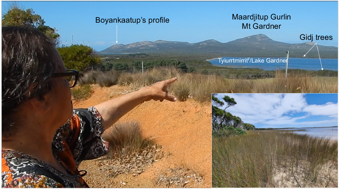
| LK: | Well we’re looking back over what they call Lake Gardner. They call that there Mount Gardner. It’s a huge thing in traditional history in Albany and in Western Australia. The part of the old campgrounds and the trade grounds up to the right of me are going back that way but this lake here was a spear collecting area, where people came down for the trade and especially for spears. They were good down here. But we’re looking back over here, over my head, to Boyankaatup (profile) from this view (Fig. 9). And you can still see his head and his face sitting up there in that thing, looking back over towards Yilberup/Mt Manypeaks. And just down here there’s a part of this water system that goes over here as well. And there are snakes. They were so big. I remember, I do know this place because we are friends with the people that own that farm. |
| SH: | That’s Tandara? |
| LK: | Tandara. The farm Tandara. |
| SH: | Yes. |
| LK: | Owned by old man Milgrum who’s just passed away, bless his soul. But there are snakes, water snakes or whatever snakes that are so big they used to swallow sheep or small calves. And this place was renowned for snakes. So it’s very, well quite dangerous. Never walk by yourself round this bush area. Or in this water area. |
| SH: | And the name of the Taxandria juniperina that they made spears out of was? |
| LK: | The Gidj, the Gidj. You can see them growing. They’re actually starting to flower now, and you just see a white tint in all that growth. |
| SH: | So it’s the same name for the spear and for that tree? |
| LK: | Yes. Gidj. That’s where they got the Gidgie word from. |
| SH: | Like Gidgegannup? |
| LK: | Oh Gidgegannup could be, but the name, the Gidj, when you go, when people go spear fishing or whatever and they take Gidgies with them, that’s where it got its name from. The Gidgie sticks. The spear sticks of this area. That’s Noongar, that’s Mirningar language. |
| SH: | Gidj? |
| LK: | Gidj. For spear. |
| SH: | So we’ve got the big trade centre on the dunes to have a look at now. |
| LK: | Yes. Yes. |
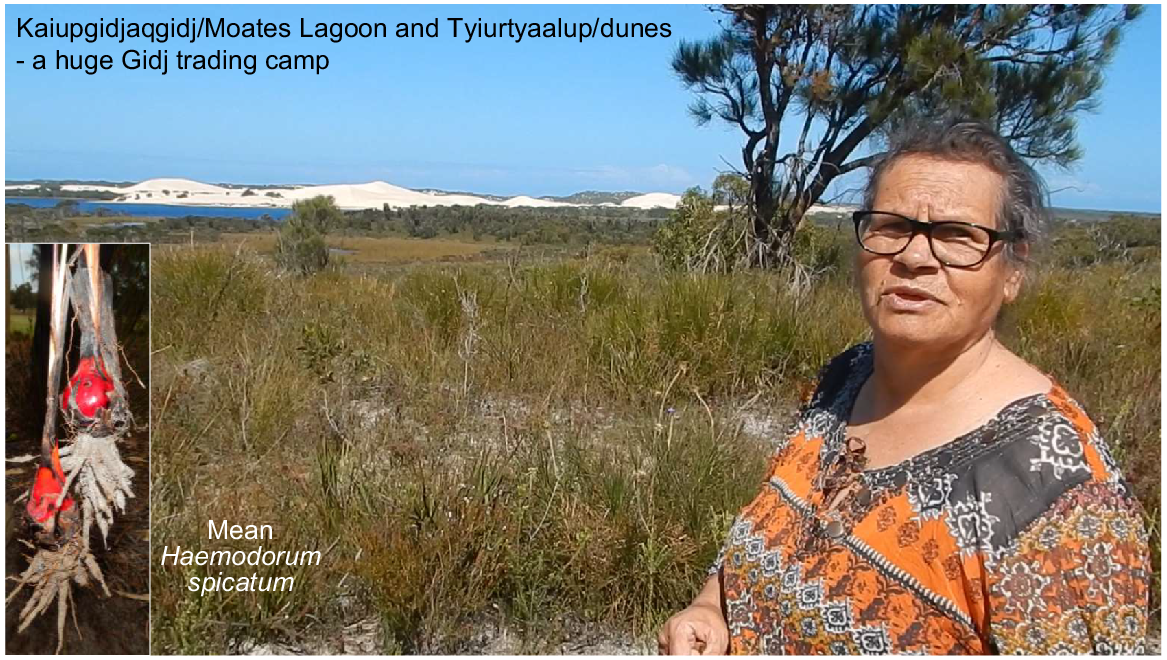
Part 4. Kaiupgidjukgidj/Moates Lagoon and Tyiurrtyaalup/dunes – the huge trade camp – Lynette Knapp and Stephen Hopper. 10 April 2017
| SH: | What’s the significance of this place Lynette? |
| LK: | This is the area that I spoke about in the last little bit of video. This is the area where the huge trade camp used to be, and people used to come from their Country, or Countries, to here. They were allowed here, and to trade for those spears that we spoke of (Fig. 10). |
| SH: | From how far away would people come? |
| LK: | Oh, goodness. Central desert probably. |
| SH: | Really? |
| LK: | Yes! We found stone over there that came from the top of Queensland. Stone. |
| SH: | Spears were that good that people would come thousands of kilometres? |
| LK: | Yeah, yes. Thousands of kilometres they’d walk just to do trade, trade down in this area. And that’s what’s left of it all (pointing south to Tyiurrtyaalup/the bare dunes lining the southern shore of Kaiupgidjukgidj/Moates Lagoon). Every time I come here it reminds me of the old people. And the way they lived. |
| SH: | So the camps, where would people actually camp? |
| LK: | Where all those dunes are, they’d have their camps all set up over that way. That would be all their Kornts, their Mia-Mias, as they’re called. And that’s what it’s turned into (bare dunes). People will tell you that animals (rabbits) did that but it wasn’t animals at all. It was a huge trade area, this place. But you can see all the fresh water? |
| SH: | Yeah that’s a place called Moates Lagoon these days. |
| LK: | Oh. |
| SH: | By nydiyang/white people. Probably has a good Noongar name? |
| LK: | Yeah, yeah it does. I’ll have to remember, bring it back when I do another thing (subsequently remembered as Kaiupgidjukgidj). But it’s full of fish, full of marron and gilgies (Cherax quinquecarinatus). Full of everything. And the bird life there is second to none, when you go in the quiet areas. But like a lot of places, a lot of people don’t realise how particularly special that is. We go to other countries to see this kind of thing and we can’t even be bothered to look at our own, amazing place. And this, when we were looking at the spear, the Gidj, this is a young one of that plant. And in blossom. When it’s in blossom, the season for it to be in blossom, and specially if it’s hanging over waterways, and the bees and the insects all love these, but they fill up with nectar and pollen and things get heavy and they drop in the water. And that fed all the mullet. All the Mederung. All the Mederung. |
| SH: | So that would be a signal, this flowering? |
| LK: | When this flowers, it was a signal to know that those mullet were biting and taking things off the top of the water. And they’d be fat. The mullet fat was just as prized as the emu (Dromaius novaehollandiae) fat and the kangaroo fat was as well, for medicinal reasons. |
| SH: | There’s a bulb crop here too? |
| LK: | Yeah, Mean (Haemodorum spicatum). To the Albany, the Albany Mirning people, that blood root that’s called Mean. And it’s connected somehow to why the Mirningar people were called Mirning, because when they ate the blood root it was one of the main staple diets. This would be all red (stroking chin below the mouth) from that. |
| SH: | And your tongue would go purple? |
| LK: | Yeah, your tongue would go purple or red. It’d be horrible tasting but they loved it. But the black stalks you see, are those. |
| SH: | And did you have to cook it or could you eat it raw? |
| LK: | You could eat it raw, but it’d be better cooked because they’re funny tasting things. |
South of Two Peoples Bay Road in the west of Two Peoples Bay Nature Reserve, Kaiupgidjukgidj/Moates Lagoon and Tyiurtyaalup/dunes are where people camped to trade Gidj spears. Also, the red bulbs of mean (Haemodorum spicatum) were a staple in summer, turning peoples’ mouths and lips purple due to the strong red pigmentation. Photos S. D. Hopper.
And you’d have to, well I’d prefer them cooked. I’d just put them on the coals or ashes, they cooked up and that takes most of that tarty taste out. But this time of year they’re not as good as they normally are because they’re getting ready for their wet season.
| SH: | Were there prohibitions on when you could dig it up? |
| LK: | With all plants, yeah. All plants you had to use at certain times of the year. And there were more plants that you could use at any time. But to get the best out of them, they were used, dug up at a certain time of the year. |
| SH: | And so for the Mean? |
| LK: | Mean? |
| SH: | It was a certain time? |
| LK: | Summer. |
| SH: | In the summer was it? That was the best time. |
| LK: | Yeah, mostly summer. And because it was just all year round down here, the winter, they would have dug them up. If I dug one up to eat it, I wouldn’t touch it if it was a pale colour, which is what it is now. You get some that are, these are probably… because they’ve had the sun all day, these are probably OK. |
| SH: | I can imagine the old people, the women and girls digging here. |
| LK: | Oh yeah, they’d love all that. They’d all have a fight over that probably! But there’s also another one that we call Kwerding (Haemodorum discolor), and it’s got different leaves altogether that we will pull up anywhere, dig that up. |
| SH: | This Mean has a round leaf, a round section, like a leek, but Kwerding is flat and bit curly? Is that the shape? |
| LK: | Oh the leaf? |
| SH: | Yeah. |
| LK: | Yeah, that’s got a special leaf. There’s normally one on it that’s curly, which is used, how you can tell the difference between these flat leafed things (pointing to Anarthria and Lepidosperma sedges) and the Kwerding itself. And it grows in gravelly, sandy colour places like this. But more out sort of east of here. |
| SH: | Away from the coast? |
| LK: | Away from the coast. Not all together, that’s not found. We lived on it, so a lot of that wasn’t far off the coast. But sort of gravelly areas. It’s like most plants that have certain things in the soil. |
| SH: | Can you remember a couple of places where you particularly enjoyed eating it? |
| LK: | The Gardiner River area, Bremer, Cape Riche. Oh yeah, most of our walks. Yeah most of our places where we went to sleep, walked around the place, found them all. |
| SH: | What about further inland when you were living at Kebaringup near Gnowangerup? |
| LK: | Yes, yes. Found some inland. Yep, found a bit inland. But they like the gravelly areas. But when they were around here, they’d target mainly the fishing, gilgies and marron. Marron are quite beautiful in there, beautiful. And just up the river, in one of the tributaries to the lake up here, there’s a little red fish, that’s so long (indicating about 3–4 cm long), and a little brown fish up there. |
| SH: | Oh on the Goodga River? |
| LK: | Yeah that one. |
| SH: | Just over the hill? |
| LK: | Yeah. So that’s one of the big tributaries for this. |
| SH: | Fortunately, these dunes system (Tyiurrtyaalup) and the big lake (Kaiupgidjukgidj) are all in Two Peoples Bay Nature Reserve, so they can’t be developed. |
| LK: | OK, awesome. We’re having trouble with people developing whatever. Even the roads are a little bit off-putting because they go through areas and rare plants systems and that’s how we learn, but it’s nice to see that this is still intact. |
| SH: | There’s plenty of Albany pitcher plants (Cephalotus follicularis) here as well. |
| LK: | Yes. |
| SH: | Peaty soils – the pitcher plant loves swamps. |
| LK: | Yeah they like it as well don’t they? They’re a special plant, all plants are special plants because they all belong to somebody’s totem. You know everything’s totemic with us. You know some families belong to, because I’m standing around a variety of stuff that could probably involve about 10 different families. It’s just a different types of things. |
| SH: | I was told by (Goreng man) Aden Eades that Gidj was his totem. Spear was his totem. |
| LK: | OK, awesome. |
| SH: | But some people might have Mean as a totem? |
| LK: | Mean? Yes, definitely. I think that it ran in the Mirning people’s thing, but it was a staple food diet. Trees and things are pretty full in the totemic system, but so are the other, all flowering plants as well. |
| SH: | Right, thanks very much. |
Part 5. Two Peoples Bay beach traditional camp and women’s plants – Lynette Knapp and Stephen Hopper. 10 April 2017
| LK: | We’ve come here today (Two Peoples Bay Beach picnic ground) to the place where the women camped when they were preparing that girl (Yirdiyan) for the wedding. And when we see these stories it’s good because it verifies that the granny-eyed wattle, or whatever they call it, cyclops wattle (Fig. 11). |
| SH: | Yeah, cyclops. |
| LK: | Is the one that tells me and many other people, that the old women used to camp here in this area together. It was the women who carried seeds around in their little bags, for kids to mix in with fish. But this is one of the big camping areas that we were talking about in that story. And you can see that we’re still within earshot of Yilberup. We’ll see. |
| SH: | So this is the main Two Peoples Bay beach picnic area? |
| LK: | Two Peoples Bay beach. Yes. |
| SH: | And you mentioned where they got water from? |
| LK: | Yeah to the west of here, just up there about a 100 m, there’s a little creek that comes out water, that was fresh in them days. And it came from the great lakes over the other side (Moates and Gardner Lakes) where the old camps were and the sand dunes that run out of those lakes. But this plant here is what we call the Yorga’s (women’s) plant, and it’s used in various ways for women. That grows prolifically round here but it also indicates ground water. So where-ever this is you find appropriate places to dig. You almost always dig up, dig up water. So there’s no shortage of water. And this (pointing to the sword sedge Lepidosperma effusum) is also used in basket weaving and women’s business, that I probably can’t explain on camera. But it’s an appropriate plant. It’s women’s plant. |
| SH: | Is it called Gerbain (same as Lepidosperma gladiatum)? |
| LK: | Gerbain. Yeah. |
| SH: | And this is the one that has edible leaf bases? |
| LK: | Yes. |
| SH: | Do you want to show us how to grab something to eat off it? |
| LK: | Well it was a good plant to show the kids how to feed themselves I suppose. And normally you’d look for a young leaf in the centre of things that you just pull out like that. There’s a knack to that. And the white, the white area would be a good source of having a bit of a feed. And water. Pretty moist. Really, really moist. See the water on my skin there? But that’s tucker, bush tucker. |
| SH: | And you’d eat that eh? |
| LK: | Yeah. Yeah you’d eat that. And it’s normally in the middle of the plant. |
| SH: | So can I try? |
| LK: | Oh you can have a go! |
| SH: | Mm it’s a bit… |
| LK: | Taste alright? Yeah, yeah they’d chew that until the white runs out… |
| SH: | Gerbain? |
| LK: | Gerbain! |
LK highlights cyclops wattle (Acacia cyclops) as an indicator of the old women bringing seeds into the main Two Peoples Bay camp to add flavour to meat dishes. The red fleshy material surrounding the seeds in the dry pods make the eye-like appearance. The green pods when rubbed vigorously with water form a soap lather. Also, a form of coastal sword sedge or Gerbain (Lepidosperma effusum) is a women’s plant with edible leaf bases and used for secret business. Photos S. D. Hopper.
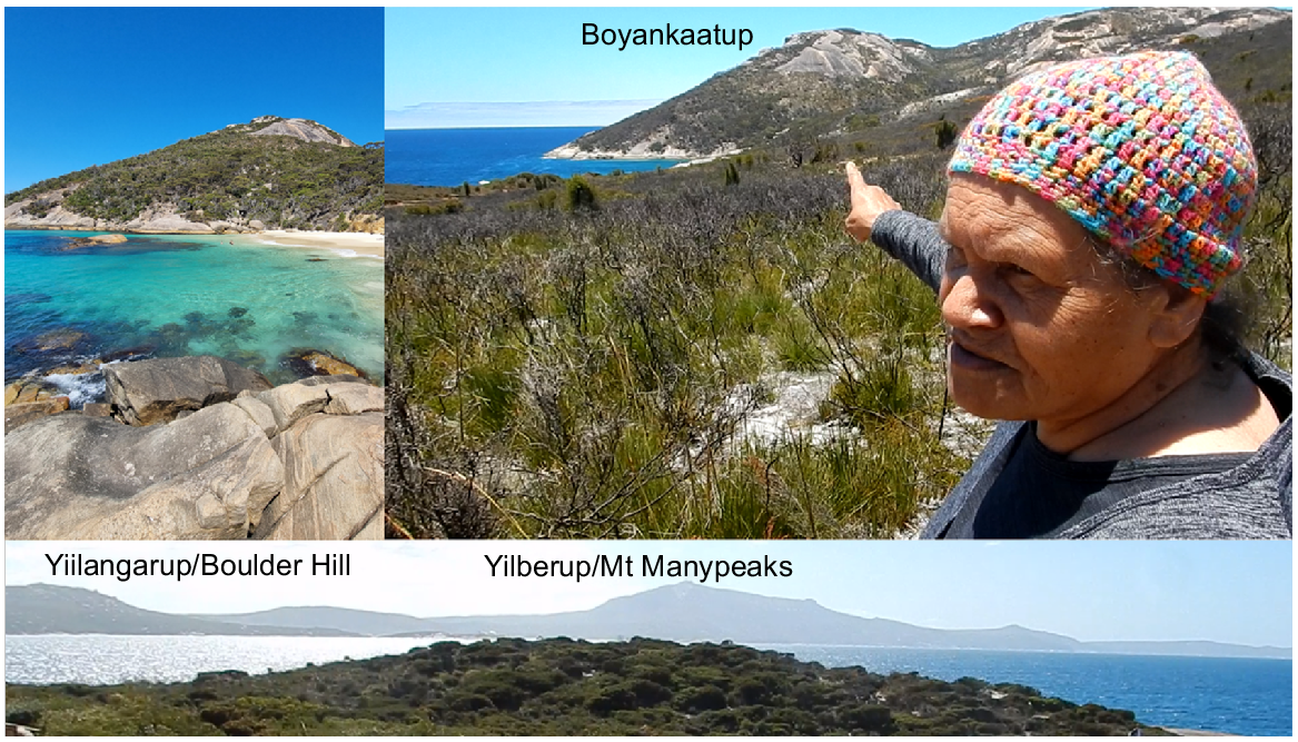
Part 6. Kinjaarling, Boyankaatup’s profile at Little Beach, Yilberup/Mt Manypeaks and Waychinicup – Wiernyert/Dreaming stories Lynette Knapp yarning with Stephen Hopper. 10 April 2017
| SH: | We’re situated at Little Beach in Two People’s Bay Nature Reserve and we’re going to talk about the story of this place in a minute but firstly, Lynette, can you tell a little bit about the name for Albany and what it might mean? |
| LK: | OK. My family, we were regulars on the coastline. We used to travel from Denmark in the west, right through to Israelite Bay in the east. The Noongar name that they use for Albany was Kinjaarling (Goode et al. 2005), and was also, there was another word also used- Chenjaarling. Chenj is rain, light rain called Chenj, and it normally happens when somebody that is connected to the Country, someone that’s maybe an Elder, but if they’re connected to this Country, that was this region’s way of crying. And telling people that someone from the Country has died, and sorrow. Tells of sorrow. So when we see the Chenj, we knew that there’s someone gone. |
| SH: | Was it a special sort of rain? |
| LK: | Yeah it was a light, very light misty rain. The type that would soak into you. And we always put it down to being like soaking, and maybe that person getting sick from that, from that kind of weather. And we knew that most Noongars in my time when I was a kid all lived in the bush, they didn’t live in the houses and suburbs. So yeah, they never had that connection with getting wet. But that was called Chenj. |
Kinjaarling means ‘place of rain’, so when you was travelling and someone said
‘Where you going?’ and they said ‘Kinjaarling’ or ‘Chenjaarling’ we knew they were headed to where Albany now is. This is all a part of Albany as well. This area down here. Boyankaatup, that’s one of the people that was involved. They sent him to sleep and he was a sentry. He was the one that was looking out for people, because in one of the families from Yilberup/Mt Manypeaks, over in that direction (to the north, Fig. 12), there was a girl and a boy who fell in love and it was taboo. So when the oldies, when the women got hold of that news they decided that that was to stop. So they arranged a marriage for this girl. And they brought her over to Two People’s Bay, where Two People’s Bay now is to get her ready for marriage. And when this other person arrived, this bloke arrived from Kangaroo people, which is out near the Stirlings, she was to leave and get away from the fella, Djimaalap, who is what we call the noisy scrub-bird now. And the noisy scrub-bird is pretty rare down here. He lives in this area, and he was the boy that the girl had to part from. When they were preparing her for marriage, Djimaalap and Boyankaatup decided to come around, sneak around, and he (Djimaalap said to Boyankaatup), he said ‘Can you keep an eye out while I go in and I’ll run away, get my woman back and run away with her. I don’t want her marrying anyone else.’
LK pointing to Boyankaatup’s head in profile at the south-west end of Little Beach on Two Peoples Bay Nature Reserve. Boyankaatup is locked in stone looking north at Yilberup/Mt Manypeaks. This is a central location for the story of Djimaalap and Yerdiyan, turned into birds for disobeying Elders and attempting to elope, 20 December 2016. Photos S. D. Hopper.
And so, he got Boyankaatup to sit and wait and watch back home to see if anyone was following.
Anyway he (Djimaalup) snuck into camp and got caught. And was punished for that. Punished. The girl eventually had to marry the boy she was intended for. Boyankaatup was turned into stone. That’s him there (pointing to the granite hilltop at the west-southwest end of Waterfall Beach/Little Beach), still keeping an eye on the Country for anyone sneaking in (Fig. 12). And the bloke that wanted his woman back is Djimaalap, which is the noisy scrub-bird. You hear him calling out. He’s still lost, he still calls out looking for his bride-to-be. And this is this whole area.
With Yilberup, Mount Manypeaks, that’s our connection to the astral, astral stuff down here (pointing upwards). That’s our connection to the sky. And the stories of the sky. That’s where there used to be a family of emus, and there was one emu who thought he knew more than everybody else and he boasted about everything and didn’t do the right thing. He broke every law that was around, every black fella law. He was just a silly, naughty person. All the oldies, he made that much trouble, all the Elders got together down in this area and decided to punish him by grabbing him and slinging him up into the Milky Way. And when they did that, you know they told him ‘You can’t stay – you’re just causing too much trouble’. We just want to go along and be normal emus, we don’t wanna be troublemakers. So they grabbed him and they threw him up into the Milky Way, and all the little stars that fell out of the Milky Way to make way for the emu, are all represented by the stone peaks on Yilberup, over in that direction (to the north). And you can see them starting from the hill across there (Yiilangarup/Boulder Hill north-northwest) and going right around. They go into Cheynes Beach (to the north-east). So all those little rocks are from the sky. So that’s our Astral connection.
| SH: | So that’s the rocks above Norman’s (Betty’s) beach? |
| LK: | Norman’s beach yes. |
| SH: | Are the nearest ones? |
| LK: | Yes. |
| SH: | Right around to? |
| LK: | Right around to Cheyne’s Beach. |
| SH: | To Cheyne’s Beach? So the whole Manypeaks National Park as we now call it? |
| LK: | Yeah, yep. Yep. |
| SH: | And I’ll just pan around now to look at those hills. |
| LK: | There’s Yilberup. |
| SH: | That’s Norman’s Beach straight down the pathway. |
| LK: | Yes. |
| SH: | And there’s Manypeaks now coming into view, right around to Cheyne’s Beach and Bald Island. And is there another side to the story of Yilberup as well that you mentioned? |
| LK: | Yilberup is Waychinicup, or what they call Waychinicup now, and Waychinicup that’s there now isn’t the real Waychinicup. Waychinicup is further over. It’s a small beach, long beach, where no one was allowed to go. But my family camped over there, they camped over there, but before, in the traditional times, and the stories that were passed down to me were that it was a healing place. We call it Yilberup. So if anybody was sick or wounded or whatever they’d go over there and heal. But the ones that didn’t go back to the people, would have eventually passed away, which is why they never returned. And the Elders, the men, used to move in looking for these people, and if they were noitch (dead), they’d get them and put them on rafts and float them out in the water. Give them up to the ocean. Because the ocean’s a great big part of our culture. Once we’re finished with our totems here (on land) we take our long journey to this land you see between the sky and the sea (Kooranup). You become part of the sea totems, so it’s pretty high. Mount Manypeaks is a place also of healing plants. Got some healing plants over there and so they heal. But mainly not (relying) on plants. A big thing of healing, you know when we had sores on our feet or our legs, you’d use urine, you’d piddle on your sores, without touching it. Cause once it’s touched it becomes infected. |
| SH: | Infected? |
| LK: | You can’t treat any sore or rashes or anything with it. |
| SH: | So you had a sort of custom almost like a parallel to the Viking burials, with people who are noitch – noitch means passed away? |
| LK: | Yes, yes. But that was only people that were round here, were the only people that did those. |
| SH: | Did that? |
| LK: | Yep. |
| SH: | Put the person who’s passed away on a log raft and pushed them out to sea? |
| LK: | Yes. And you can see in the trees over there, they go (bend) over and their whole branches have got a bit of a hook on the end of it (Fig. 13). And that’s where the old camps used to be, the old healing camps. And that’s all messed up now with the DEC, Department of Environment (now DBCA, Department of Biodiversity, Conservation and Attractions). They’ve put in campsites and things, and they’ve cleared all our trees. |
| SH: | So what’s the significance of the hooks? |
| LK: | The hooks were where they pull the tree over and hooked them into the ground, you know with stakes. And then they put their bush or paperbark- Yoorl- over the top for protection. |
| SH: | Protection. So the hook would help? |
| LK: | The hook would stay in the ground and keep the tree. |
| SH: | The tree would stay put? |
| LK: | Over like that, yeah. |
| SH: | Yes. So you’d bury the hook basically and hold it in place? |
| LK: | Yeah yeah yeah. You’d get it and stake it down. And the tree would, the longer they left it there, the part of the branch had grown upwards, you know. So I don’t know if there’s any more left there. It would be nice to go over and have a look one day. So we must make Yilberup part of our story. |
| SH: | That sounds like a plan. And just to nail Waychinicup, real Waychinicup, is it past Cheyne Beach caravan park? |
| LK: | No, it’s in between Yilberup or where they call Waychinicup (Estuary) now, and Cheyne Beach (Fig. 1). But it’s not very far past over the hill, because I remember my two aunties and an uncle, but the uncle was a cousin. They, Uncle Harold McEvoy’s parents and our parents used to work for Hassells, and they built a fenceline up and over, over half-way up Mount Manypeaks, or Yilberup. And there’s still a fence line there, apparently with stone holding it up, because they couldn’t dig into rock. And I’ve never seen it! But I’ve heard so much about it. My two aunties and uncle were left home in the camp, and the horses were there. The oldies and everyone else had walked upslope to do this fence line. And they decided to get up to some mischief because they were told never to go there (Waychinicup) because it was so sacred. It had a burial cave there. When everybody had disappeared for a while, they decided to jump on those horses to take them up over the hills, and long onto that beach where they were not allowed to go. And as they waited for the huge waves to go back, they got the horses and they just galloped over there. Because they knew, they rode without saddles and things, you know. So they were holding onto the manes to stay on and when they got halfway across this huge wave came up and just dumped them out onto the beach and took the horses. But the horses were eventually recovered, and one of them wasn’t in very good shape. And when they got home, they got the flogging of their lives. They just never ever forgot it. I got that story from one of the aunties that was on those horses. |
| SH: | So which two aunties are you talking about Lynette? |
| LK: | Oh Aunty Bonnie (Fig. 3), who’s the mother of Albert Knapp, and Aunty Lena, who’s Mrs Joe Woods. And they lived in and around Gnowangerup area. |
| SH: | Were they teenagers when they did this? |
| LK: | They were teenagers! They were naughty. Naughty! |
| SH: | There’s a beach called I think Mermaid Beach, |
| LK: | Mermaid Beach? |
| SH: | Opposite Bald Island. Are you talking about somewhere like that place? |
| LK: | Oh they might be there, but I thought it might have been closer to Waychinicup where the Waychinicup (Estuary lies), but that’s the proper Waychinicup that I’m talking about. |
| SH: | Yes. |
| LK: | And that’s got like an emu print on a rock, and what it says is probably a natural crack, but it’s what they say you can’t go past. |
| SH: | So is this up on top of the beach is it? |
| LK: | These three, yeah right on the beach, or near the beach. |
| SH: | Oh right on the beach? |
| LK: | And this is where these three people didn’t listen. They rode past that, they thought they were better than everyone else! |
| SH: | Oh. |
| LK: | But they learnt their lesson and they never ever forgot it. And I, my, one of my, the Aunty Bonnie that I spoke to, she was in her eighties when she was telling me that one. Yeah, she never ever forgot it. Cause Grandfather always carried a whip. And they got a whipping. Not a wopping, a whipping! |
| SH: | A whipping! |
| LK: | Yeah! |
| SH: | And finally, then, can you just point out Boyankaatup’s profile, and tell us, describe it. Is it…? There’s a big hill there? |
| LK: | There’s a huge hill here. |
| SH: | Is the whole hill his head? Is that the story? |
| LK: | That’s his head and this is his beard. See all the bushes? That’s his beard. |
| SH: | Ah. |
| LK: | And you know up on the skyline, there’s his bottom lip. And I think you can actually see, cause of the fire there, you can actually see his top lip a little bit. |
| SH: | Yes. |
| LK: | And his nose, and his eyes. |
| SH: | Big flat nose, and a big brow. |
| LK: | He’s, he’s furrowed, yeah. His eyes. |
| SH: | And then all the dreadies (deadlocks) eh? |
| LK: | And all the dreadies! |
| SH: | And all the granite… |
| LK: | And all the dreadies hanging, or that’s his head. |
| SH: | Yes. |
| LK: | And he’s asleep. |
| SH: | He’s asleep is he? |
| LK: | He’s asleep. He’ll stay there for many more millions of years probably. |
| SH: | Very good. Thank you. |
Moiny tree (Eucalyptus cornuta) trained to bend over to form a kornt/hut for the healing camp by generations of the Knapp family at Waychinicup Inlet, Yilberup/Mt Manypeaks. The large poison pea (Gastrolobium bilobum) has grown up where the main use of the kornt by the Knapps would occur, 12 December 2022. Photo S. D. Hopper.
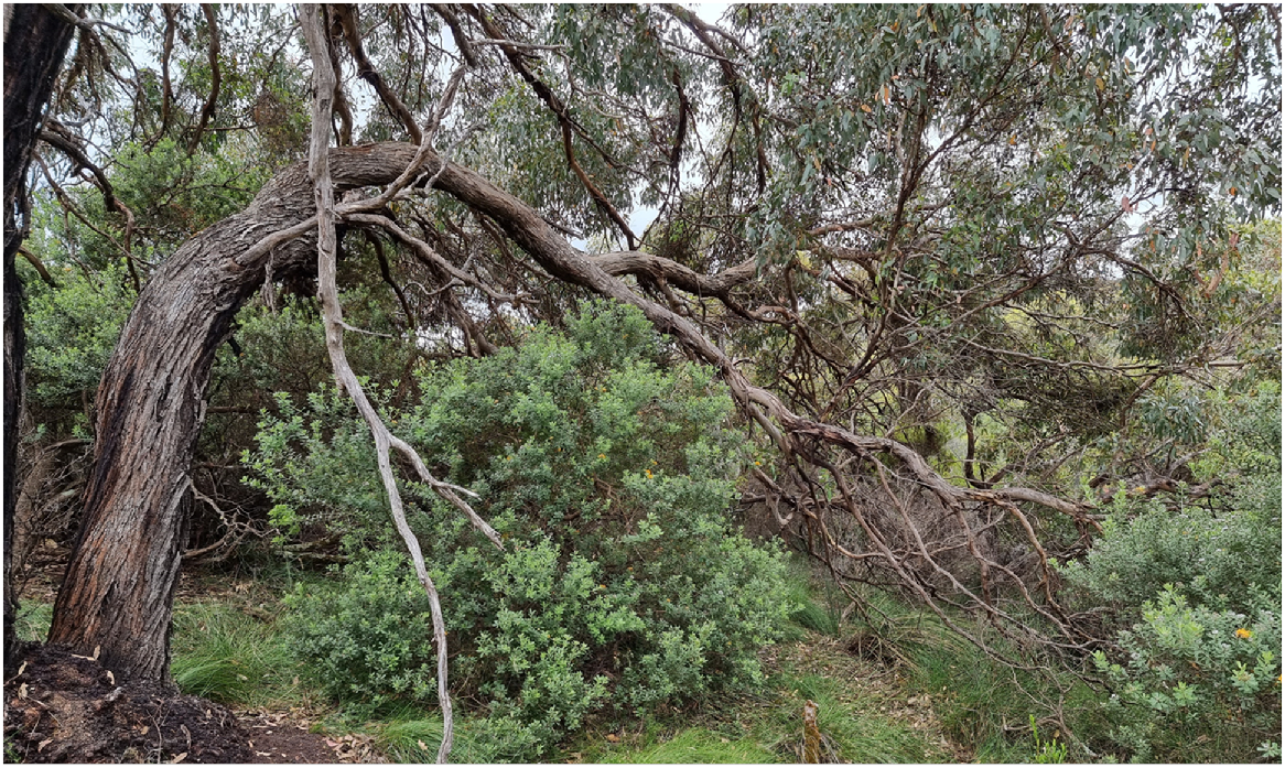
Part 7. Shark and whale calling ceremonial men’s business rock near Little Beach – Lynette Knapp and Stephen Hopper 3 November 2022
| SH: | Here’s a video of Harrison Rodd-Knapp and Billy Ugle on a mobile rock at Duke of Orleans Bay (east of Esperance) on the isthmus that connects the Hammerhead peninsular to the mainland. And they’re rocking side to side on the flat rock that’s making a deep sound of rock-on-rock on every cycle up and down. Lynette knows about these rocks. |
| LK: | The rocks that the boys are jumping on, they can be all different sizes as well. There could be some also sticking out of the water. But this one in particular grinding against the other rock brings a noise that attracts whales and sharks. So, if you’ve got something with that kind of noise that makes and put it in the water, you’d be visited in a couple of minutes by sharks in particular. |
| SH: | Really? That quickly? |
| LK: | Yeah. That quickly. And we also have one out at a place called, out here at Two Peoples Bay or around a bit more at Little Beach, past Little Beach. And it’s a big one that balances in the water, and it just creates the noise needed to bring the sharks in. And it was used for ceremonial purposes. |
| SH: | Was it? |
| LK: | Yes. Oh yes. |
| SH: | By your family? |
| LK: | We’re whale people. Yeah, we’re shell people. |
| SH: | Of course. Yes. |
| LK: | So, ceremonial as well. Particularly with men probably. |
| SH: | So, have you observed family members use these things? |
| LK: | Well, my Dad was with me when we found the rock that’s floating in the water out at, past Little Beach. And he told me about it. |
| SH: | He told you that’s what it’s for. |
| LK: | He told me about it. That’s what it was for, was bringing in the sharks and the whales. The whales were about, but more so the sharks because they’re there all the time. |
| SH: | And why would they want to bring in the sharks? Do you know? |
| LK: | No, I don’t know. I don’t know men’s business. |
| SH: | I see. Yeah. Yeah. |
| LK: | Yeah. Yeah. He told me it was ceremonial stuff for the shell men. |
| SH: | Oh, was it? So, it’s men’s business. Yeah. Terrific. I’ll just turn on the video here so we can listen to the sound again. |
| LK: | Yeah. |
| SH: | There it is with the two boys. |
VIDEO – tapping, rocking sound (Fig. 14).
Harrison Rodd-Knapp and Billy Ugle located the right point to stand on this rock and shift their weight sideways back and forth to make the rock hinge up and down, with a cyclical rock-on-rock deep grinding sound on each up and down movement. The noise was either part of Seven Sisters Wiernyert/Dreaming or used for calling up sharks or whales. Near Duke of Orleans Bay, 28 October 2022. Photos S. D. Hopper.
| SH: | Timing right mate. Keep it up. Hey, now you got the rhythm. That’s true, that’s the sort of noise, that deep, deep boom, boom. |
| LK: | Yeah, it’s like something in the water. Boom. Of course. Because our land is one big rock, isn’t it? |
| SH: | Of course, yeah. |
| LK: | (laughs) So, it works everywhere. |
| SH: | So, Two Peoples Bay is the only other place you’ve seen this? |
| LK: | Yeah. Two Peoples Bay. And at that time, I was quite a fit person. Dad was quite alright; he could walk along down through the bottom. But we got to this certain spot where there was a bit of a deep rock running into the ocean. And I just jumped on the rock. And she just went like that. (LK waves her flat hand up and down). |
| SH: | Started to wobble? |
| LK: | So, I sat there for about an hour. It had a different feel about it. But I didn’t move it up and down because I think I was frightened of the rock going into the water. |
| SH: | Oh, really. Yeah. Yeah. |
| LK: | Yeah. So, I don’t know how it’s balancing. It’s just amazing. |
| SH: | Yeah. Must be just on a pivot. And when it rocks it just scrapes against another rock to get that deep sound. Is that the story? (Fig. 14) |
| LK: | Yeah. It just seemed to be sitting in something. And that must be a natural hinge that was going. And it was making the same noise the rock is. |
| SH: | Same noise. |
| LK: | As the rock that the boys are standing on. |
| SH: | I’ll just mention, the only place I’ve seen this phenomenon is at the entrance to the Nornalup Inlet where Garry Muir showed me (Muir 2020). |
| LK: | Yeah. Wow. |
| SH: | He’s got a YouTube video of about 20 school kids jumping up and down. |
| LK: | Up and down on it. Wow. |
| SH: | And it does the same thing. |
| LK: | And was it out of the water like that or was it in the water? |
| SH: | Yeah. Out of the water. |
| LK: | Wow. |
| SH: | Thanks Lynette, that’s great. |
| LK: | Nice one. |
Part 8. Floating Rocks and Seven Sisters Wiernyert/Dreaming (Neale 2017) – Dion Cummings and Stephen Hopper at Naarup/Waterfall Beach, Two Peoples Bay Nature Reserve. 15 December 2022
| SH: | Dion, we were talking with your Mum, who mentioned there’s a shark and whale calling rock here? |
| DC: | Yeah, it’s supposed to be around the corner there (Fig. 15). I can’t remember, I was a bit too young back then, but Mum will point it out. Yeah. |
| SH: | Yeah. |
| DC: | Along the coastline there’s a lot of floating rocks, like right next to those (solid) ones. Like this one here. Sometimes you come out and next minute it’d be floatin’ but if you stay on it, it’s part of the Seven Sisters trek, so when that bloke grabbed his wives in Albany, to hold marriages. They go back towards Seven Sisters New South Wales and all that. And they’d go along the coastline, and every floating rock would have something to do with the Seven Sisters. So the women would sit on the rock, and the old bloke would sing his song. Yeah. But he wouldn’t get on the rock and sing. |
| SH: | He wouldn’t sing on the rock? |
| DC: | That was their (the women’s) rock because it was part of the Seven Sisters story. |
| SH: | So were they calling up sharks and whales? The Seven Sisters in that Wiernyert/Dreaming story? With the big booming sound that you get? |
| DC: | They were looking for their dog. |
| SH: | Their dog? |
| DC: | Their dingo. Took off and went huntin’ and joined his mob over here. |
| SH: | Yeah. |
| DC: | So when they heard the howling of them trying to catch the emu, over in New South Wales, they got up and they heard all the big commotion and they knew where the dingo was. Cause they called him. Heard his voice. (Dion here is alluding to Alf Knapp’s big creation story for Albany involving ancestral twert/dingoes and a wagyl/rainbow serpent chasing a waitch/emu from Alice Springs to Torndirrup peninsula south of Albany.) |
| SH: | Yeah. |
| DC: | So they come over (west) lookin’ for him. |
| SH: | Yep. |
| DC: | But before they come over, they got the advice from an old Elder over there (east) not to look at the harbour ‘cause it was full of black magic. |
| SH: | Ah. |
| DC: | So as soon as they looked at the harbour that’s when they turned to stone around the harbour. |
| SH: | Yes. |
| DC: | Yeah. |
| SH: | Yeah. And you mentioned that the Menang were the only people who knew where sister number seven was? |
| DC: | Yeah. That’s right. That was the trick. So to find out where the seventh sister was, you’d have to go across (from Albany to Torndirrup) and through the traditional law. You know what I mean? Then you become a secret, come into that mob, and you wouldn’t be able to leave. |
| SH: | Is that the story? |
| DC: | Yeah. |
| SH: | Yeah. What a spot, eh? |
DC points where the shark and whale calling rock is located ‘around the corner’ from Waterfall Beach. He relayed that these ‘floating rocks’ were associated with Seven Sisters Wiernyert/Dreaming as special places along the coast where the women sat. Lynette’s father, on the other hand, told her they were ceremonial men’s business sites used for calling up sharks and whales, 15 December 2022. Photo S. D. Hopper.
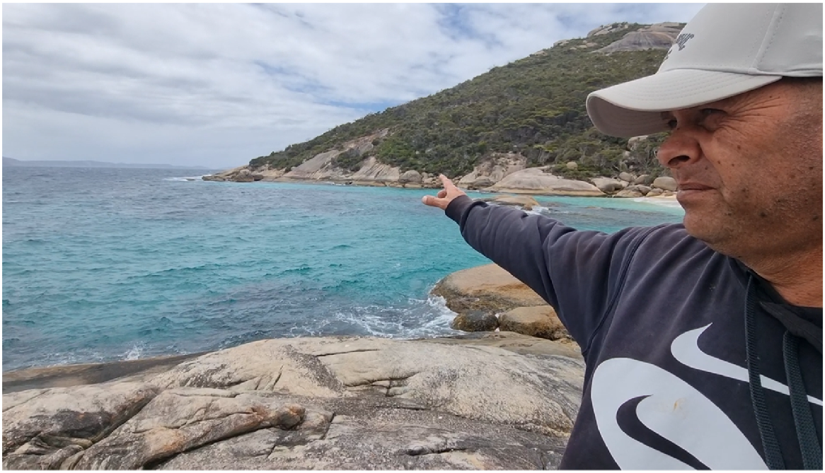
Part 9. Yiilangarup/Boulder Hill overlooking Two Peoples Bay – the big fight over Tandara’s baby and Seven Sisters Wiernyert/Dreaming – Dion Cummings and Stephen Hopper. 28 September 2022
| SH: | I’m with Dion Cummings standing on the bend which takes you down to Betty’s Beach just below Yillangarup/Boulder Hill (Fig. 16). And Dion you’ve got some men’s business stories here eh? |
| DC: | Well the whole story about this whole area is when Boyankaatup was born from one of the Seven Sisters (Neale 2017), that’s Boyankaatup over there yep (camera pans to south at the Madddjitup Gurlin/Mt Gardner inselberg). When he was born from one of the Seven Sisters, Djimaalup the big chief stuck him here to teach him how to live off the land. But he stuck him here with his daughter, Tandara, (indicating southwest) and his son (indicating north to Yilberup/Mt Manypeaks), and they’re supposed to get married together, they were supposed to marry each other; they were promised to each other. |
| SH: | The daughter and son? |
| DC: | Yeah. They was promised to each other so Djimaalap he used to go to Poikeclerup Hill and turn into a noisy scrub-bird and he used to watch over ‘em. Come here and they didn’t realise he was looking after ‘em, making sure they was alright. Anyway, Tandara ended up getting pregnant and she was in love with Boyankaatup but the other brother didn’t accept them, so they didn’t know who the father of the baby was. They had a big argument and they come to this one hill which was all dirt and Boyankaatup used to grab the sand dunes over at Two Peoples, which used to be all gravel granite rock. But Boyankaatup grabbed it rock by rock, throwing it at Yilberup. And Yilberup over here, see where the sand dunes over there he grabbed all the rocks from there and throwing them one by one but they was all ducking, ducking each other and they hit the hill here and created all the boulders on the hill (Yillangarup). And Tandara got sick of the arguing so she grabbed her baby and stuck him on side of the hill (Yillangarup) to stop ‘em arguing and then Yilberup saw the baby, so he come all the way from over there with his number seven (kylie/)boomerang and he realised that the baby wasn’t his it was Boyankaatup’s son. So what he done he hit the side of the hill over here and created a little spring that comes down to the creek over here and he made the creek with his number seven boomerang around the baby and then he was that wild (meaning, he was so angry) that he hit the baby in the head which is laying here and the baby is a boy you can see the part there and the head rolled all the way down towards the beach. At Betty’s Beach. |
| SH: | You can still see the head at Betty’s Beach? |
| DC: | Yeah. Tandara realised that her son had died so near the little hill at East Bay over here, she ripped out her heart. Tandara ripped out her heart which is the hill at East Bay (Koortyiil) and that’s the only red hill here which is her heart. She cried all the way and went and laid, where she is laying now and covered herself halfway up with the dirt and all the rocks in the ground and laid there and died. |
| SH: | Oh. |
| DC: | So the lagoons you see near Tandara over here, are the ones she created when she scooped up the dirt from the Earth to bury herself as she died. This place at the north end of Two Peoples Bay, that hill of red dirt represents Tandara’s heart (hence Koortyill is its name). So when Tandara was crying and the two brothers, Boyankaatup and Yilberup were arguing over whose baby it was. The baby got its head chopped off by Yilberup and Tanadara started crying and hitting herself in the head with rocks which represents the red rocks down there. And also when she knew she was going to die she ripped her heart out and popped her heart here and she fell down. As she fell down she dug all the dirt up and made the lagoon (behind the north end of Two Peoples Bay beach) here, see how it’s all been pushed up (Fig. 17)? |
| SH: | Yes. |
| DC: | She covered herself half underneath and then laid down and died. But that’s where after she ripped her heart out, stretched her arm eastwards across the top end of Two Peoples Bay beach and put her heart there. So that hill (Koortyiil Fig. 17) represents Tandara’s heart that she ripped out. Where Tandara’s heart is ripped out up there is actually a hole in the granite rock where the town water comes from. |
| SH: | Is there? |
| DC: | Yeah. So that’s where the town’s water comes from. It is a sacred water hole and I think that’s why everybody’s having health problems. Oh yeah that’s where Tandara put her heart and that’s the only red dirt hill for hundreds of kilometres I’d say. |
| SH: | And the hill with the two bumps across there that’s Tandara herself? |
| DC: | Right here, yep that’s her mimis (breasts). |
| SH: | That’s her mimis? |
| DC: | Yep she laid down but what you can see is her mimis sticking out. Otherwise all the rocks and that covered her up in dirt. |
| SH: | Oh right. |
| DC: | So she dug this out here but where she cried the water come in. So she dug it out and made it but the water wasn’t there but when she cried the waters become the lagoon (Angove Lake). Yeah. |
| SH: | And just say again on that hill there’s a granite with a hole in it where her heart has come out? |
| DC: | There’s a place on the hill, I’ve been told, and they’ve never found the bottom of the waterhole. And that place represents where Tandara took her heart out and placed it here. So her heart belonged to Boyankaatup, cause if her heart belonged to Yilberup it’ll be on that side. |
| SH: | Oh I see. |
| DC: | Yeah, so she fell in love with Boyankaatup and the baby was actually Boyankaatup’s kid so, the baby’s grandparent or grandmother was the oldest one of the Seven Sisters. |
| SH: | Ah okay, yeah. |
| DC: | That what she done was laid down, pulled up all the ground all the rocks and the dirt, they created on top of the hill there, on the sides. She created the lagoon where she scooped all the dirt up, over there. And what she done, before she laid she ripped her heart out and she used her arm, halfway or about a quarter of that beach over there. Used her arms and, her heart is that little hill straight over here. |
| SH: | Hmm. |
| DC: | So she put her heart down, and where she put her heart down her arm rested on the beach. And that become the woman’s section of that beach over there. That’s the womans’ side (Fig. 17). |
| SH: | So it’s the north end of Two Peoples Bay beach? |
| DC: | Yeah. That’s where they belong to, the woman’s that’s their story. |
| SH: | Right. |
| DC: | So there, whenever she touched the beach and put her hand, her heart there with her hand and that. |
| SH: | Yep. |
| C: | That belongs to the women. |
| SH: | Does it? Yeah. |
| DC: | So that’s a part of the women’s body and it’s a part of the women’s Wiernyert/Dreaming |
| SH: | Right. |
| DC: | And then these two blokes, they had an argument and Boyankaatup threw the spear which hit Yilberup and the spear went straight through his stomach and created the tail (pointing at the lower eastern end of Yilberup/Mt Manypeaks) and he became the stingray. At the same time Boyankaatup threw the spear, Yilberup threw the number seven boomerang which is Mount Gardner on top and then Boyankaatup ended up falling into the water and becoming the shark (Fig. 17). So you got the stingray and the shark. |
| SH: | The number seven boomerang? |
| DC: | Is Mount Gardner on top. |
| SH: | That’s the tip of the boomerang |
| DC: | Yep. |
| SH: | And the handle is coming out to the peninsula, nearest to the ocean. |
| DC: | Yep. Yep. |
| SH: | So that’s the shark fin. Is the white pointer’s fin? |
| DC: | Yeah, it is the white pointer. |
| SH: | He fell in the water. |
| DC: | He fell in the water and his spirit became the shark. |
| SH: | Ah. And back to Yiilangarup/Boulder Hill here, you mentioned also there’s also caves and things? |
| DC: | On the ridge here you’ll see the white flat rock on this side and if you go to the other side you’ll see a leaning triangle rock there. |
| SH: | Yeah, yeah. |
| DC: | It was actually the first rock which was thrown at each other. Boyankaatup started the fight and this bloke here (Yilberup) picked up his rocks from the sand dunes over here and threw them back. But over, up top there underneath the cave you’ll see a cave where handprints are when people come here all the time for their ceremonies and stuff. |
| SH: | So that’s the leaning rock? |
| DC: | Yeah, yeah. |
| SH: | Down below it there is a really low heath with grass trees (Kingia australis), with black boys what’s the story about them? |
| DC: | Well the black boys are the old fire places. So when the old black fellas lit fires they also left the seeds there as well so more black boys come up and more fires for the rest of their ancestors in the long run to come along do the same thing. |
| SH: | I see yeah. And on the baby’s belly you mentioned there’s some vertical white lines? |
| DC: | Yep you can see the three marks. |
| SH: | Three stripes. |
| DC: | Represents the three different tribes that live here. You got the woman’s tribe that lived over in Tandara, the Boyankaatup, the shark tribe that lived at Two Peoples and you got the stingray tribe that lived over here at Mount Manypeaks. |
| SH: | Yilberup/Mount Manypeaks? |
| DC: | That’s when they all come together and have their ceremonies. So basically it was marriage ceremonies, birthing ceremonies, ceremonies when they’re the right age to go through lore, stuff like that so. There’s a lot to do here in this one spot. |
| SH: | So it was all on Yiilangarup/Boulder Hill. It was the sort of a meeting place. |
| DC: | Yeah, meeting place. That’s why they call it Two Peoples Bay, two different tribes. |
| SH: | Oh yeah, yeah. |
| DC: | All from the one Menang tribe but then their totems were two different like the shark and the stingray. |
| SH: | The Two People’s Bay name is attributed to Rossiter I think, the American whaler here talking about the French boats meeting the American boats (actually the French sailor Ransonnet proposed the name – Chatfield and Saunders 2024). |
| DC: | Yep. |
| SH: | But, the Noongars called it Two People’s Bay a long time before that? |
| DC: | Yeah, well it’s two different tribes, this tribe over here and this tribe over there and through their Wiernyert/Dreamtime stories they never ever got along. They had to do mock arguments and stuff like that so it’s part of their spiritual way I suppose. |
| SH: | So all of these boulders are debris from the big stone fight basically? |
| DC: | Yeah, they threw rocks at each other yeah. |
| SH: | And I presume because all the ceremonies were here you’d find lots of artefacts and maybe artwork in caves? |
| DC: | Yeah. You’d find artwork up on that leaning rock up there. That’s the very first one that was thrown. That’s the story I’ve been told and that’s the story I’ll keep. |
| SH: | That’s come from your Pop again? |
| DC: | Yeah my Pop. We stood right here. |
| SH: | Ah did you? |
| DC: | Yeah right here. |
| SH: | Fantastic, how long ago was that, Dion? Do you recall? |
| DC: | I’m 44 now, I would’ve been about eight. |
| SH: | Eight wow. |
| DC: | Yeah, eight or nine. Long time ago. |
| SH: | Wonderful. I’ve never heard that story. |
| DC: | But this one here (points to island-like Djillyiranup/North Point behind, Fig. 1), when the two brothers were arguing a sea eagle (Icthyophaga leucogaster) was flying and he accidently got hit by the rocks, you can see the rocks on top of the hill there. |
| SH: | Yeah. |
| DC: | And it actually pushed him down there and he ended up turning into rock, staying here and you can see the beak over there. Wherever you see the sea eagle Wiernyert/Dreaming along the coast (Fig. 17) you know it’s men’s lore grounds. So sea eagles (Djillyiran or Chillian) are the guardians of the lore grounds down this way. |
| SH: | Thanks. |
| DC: | (Looking back up the hill) You can see the baby laying back. |
| SH: | He’s definitely a boy isn’t he? |
| DC: | Yeah (laughter). |
| SH: | He’s definitely a boy. |
| DC: | Not many people know about that. This old story, a lot of the Noongars they would’ve heard stories and they go oh yeah that’s this and that. But they don’t know the whole story from start to finish you know what I mean? That’s something you’ve got to be taught to know. |
| SH: | Now your Mum worked with her brothers and got their approval to talk a little bit about the fight between the brothers that ended up with the shark and the stingray over at The Gap in Torndirrup National Park. |
| DC: | Yeah. |
| SH: | So what’s the significance of The Gap in that story? |
| DC: | Well The Gap to me is one of the Seven Sisters laying back. Cause when they come looking for their dog, their dog ran away to join all the other dingoes to trap the emu (running from Alice Springs to Albany). So when they heard all this commotion over in New South Wales, they knew the bark. The Seven Sisters knew their dingo was over here, so they come along and they asked someone over that way because they didn’t know the land, and the person said when you get to the harbour, the koort (heart), the emu’s koort, don’t look at it cause it’s full of black magic. So when they come over they didn’t realise they was over the emu’s koort in Albany harbour (Princess Royal Harbour) and they ended up turning into the hills and the black magic ended up catching them. So when the last one was pregnant with Boyankaatup, she lays back where the Albany windfarm is. |
| SH: | Yeah. |
| DC: | All the way down to the Albany Gap (i.e. she became most of Torndirrup peninsula). When she died the chief, Djimaalap, knew that she was pregnant so he created the Albany Gap. He cut her with a cutting tool, grabbed the baby out and when the baby came out, he grabbed the afterbirth and stuck it where that rock is. |
| SH: | On the sand patch? |
| DC: | No. That rock when you going towards Quaranup and you get towards the Albany Gap Road. That rock and you say that’s men’s business, that’s actually the afterbirth of Boyankaatup. When the chief pulled him out and he cut the cord and the afterbirth and grabbed it and stuck it there where that rock is (Fig. 18). |
| SH: | So just explain to me where the rock is again? |
| DC: | Ah just before you get to the Albany Gap Road around the corner. When you are coming from Quaranup Road towards Albany Gap Road and you see that one rock and you say oh that’s the whale Wiernyert/Dreaming. |
| SH: | Oh that one. |
| DC: | That’s supposed to be the afterbirth, his afterbirth is put there. |
| SH: | I thought it was whale Wiernyert/Dreaming because it looks a bit like a whale spout but it’s actually not? |
| DC: | Yeah it looks like a whale spout but an actual whale spout is whistling rock (the summit of Stony Hill). So you got these differing stories. You’ve got this story, and then you got the other story about when the (Princess Royal) harbour was all freshwater and the freshwater turtles used to live there. All of a sudden a whale come past and he spouted and then the salt water ended up getting into the freshwater. So the two, on this side of Albany (east of), the Yakamia side, the two sacred freshwater turtles come out because the water was too salty and they come out to the sacred water holes at North Road. |
| SH: | At North Road. Ah yeah. |
| DC: | So when you look at Albany on this side (from the east) you can see the rocks (hills, Mt Melville, Mt Clarence) and it looks like shell turtles. |
| SH: | Yeah. |
| DC: | Yeah, so its two turtles coming out (eastwards). And one went in the sacred waterholes this side and the other went to sacred waterholes at Yakamia. |
| SH: | At Yakamia yeah, yeah. |
| DC: | So that’s what made Yakamia, because the whale come along, spouted the water and made the freshwater salty. |
| SH: | Yeah. So just going back to The Gap briefly, your Mum put the sign up there talking about the big fight. |
| DC: | Yep. |
| SH: | Between the two as though it happened there would be one interpretation but that is not the case? |
| DC: | No, this is where (it happened). |
| SH: | This is the fighting ground? |
| DC: | Where I showed you, he (Boyankaatup) was a baby and Djimaalap grabbed him and cleared it (making the Sand Patch) and put him next to the mother. |
| SH: | Next to the sand patch? |
| DC: | And he (Djimaalap) woke up, woke up the next morning and could still hear the baby crying. |
| SH: | Yes. |
| DC: | So he knew he was going to live. |
| SH: | Going to live yeah. |
| DC: | Knew that that baby was special. |
| SH: | Yes. |
| DC: | To be a part of the, basically born from a god it was a bit hard, you know born from a god spirit. |
| SH: | Yes. |
| DC: | Yeah but this (here at Two Peoples Bay) is where Boyankaatup was stuck out, placed here to work and live off the land. Shown how to live. |
| SH: | Ah yes. |
| DC: | Basically like a type of lore ground type of thing how to live you know. |
| SH: | And the stingray do you recall the men’s name for that? |
| DC: | That’s Yilberup. |
| SH: | That’s Yilberup? |
| DC: | Yeah Yilberup was the boy king. So he was Djimaalap’s son. |
| SH: | Yes. |
| DC: | So Djimaalap, he ended up getting to the stage where he was the Elder and this bloke here (pointing to Yilberup) took over as the king. |
| SH: | Oh okay. |
| DC: | That’s why you have King Creek coming out the other side of it (Yiilangarup/Boulder Hill). |
| SH: | Oh is it? |
| DC: | Yeah. |
| SH: | King Creek is named for here, yeah. Wonderful. |
| DC: | So he was the next in line to become big boss for the Menang Country. |
| SH: | Yeah. And the baby behind us here, you were saying he was special? |
| DC: | Yeah, he was basically like a spiritual god. |
DC at Yiilangarup/Boulder Hill relaying the men’s story of the big fight over Tandara’s baby son between step-brothers Boyankaatup and Yilberup, 28 September 2022. Photo S. D. Hopper.
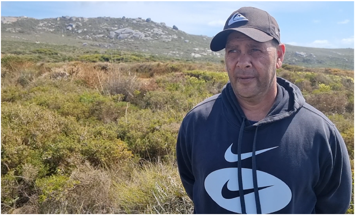
Profile of Two People’s Bay Nature Reserve as seen from the north showing the clear difference in elevation between the 408 m eastern upland and the isthmus lowlands. Men’s business in Merningar Bardok culture is concentrated east and women’s business west and north on lower boodjar/Country. Thicker white line represents Tandara’s arm where she stretched out during self-burial to emplace her heart (Koortyiil) at the top end of the Two People’s Bay beach, now women’s business Country. Bottom figure illustrates aspects of the men’s story for the creation of the Reserve’s landscapes. Notably how Boyankaatup, the orphan, was killed by a No. 7 kylie/boomerang, stumbled and tripped, became a maardjit/white pointer shark, and then turned to stone on Two Peoples Bay Nature Reserve (see oral history text for details). Photos S. D. Hopper; kylie The MET; shark guidesly.com.
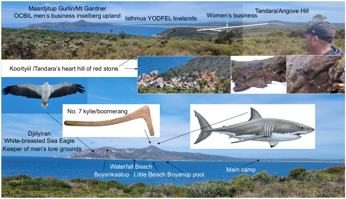
Boyankaatup’s afterbirth rock at The Gap turnoff on Frenchman’s Bay Road in Torndirrup National Park. Banksia grandis in the foreground. Photo S. D. Hopper.
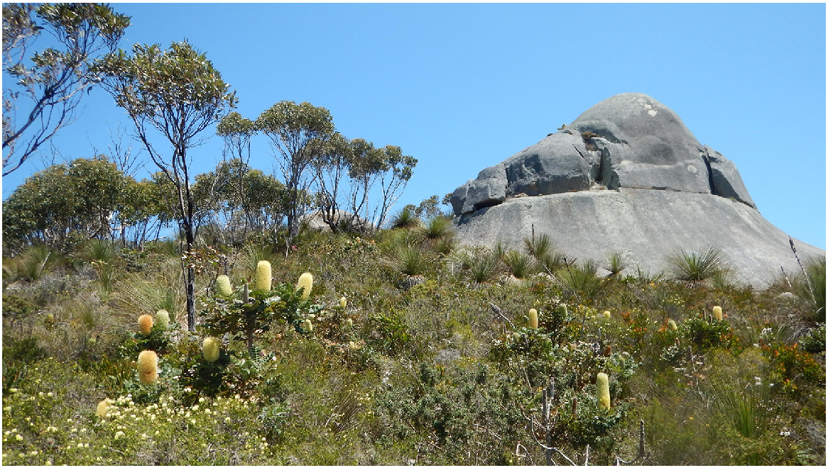
So when you get to a lot of them boy’s places, so basically get a lot of boys coming around from Two People’s Bay way. You get a lot of tribes coming in used to camp at Norman’s Beach from the other parts of Australia and tribes from over this part here at Yilberup. They all meet up (pointing to Yiilangarup/Boulder Hill) and it’s like a men’s lore business here.
| SH: | Yeah. Terrific, so you got anything else to say about the place? |
| DC: | Nah. I don’t think so. |
| SH: | That’s really impressive. This is Norman’s Beach heading over (north) to Yilberup. |
| DC: | Yes. |
| SH: | That’s where people came from over east did you say? |
| DC: | Eastern side, yeah over east. Different tribes come from inland. Menang like the Stirlings and all that stuff. |
| SH: | They all come down there (from the north)? |
| DC: | Yeah. If the Menang people they seen someone was in a tribe like the Bibbulmun, Whadjuk, whatever tribe was around them, not every tribe could come into Albany. The only time they could come into Albany was if they was chosen by the Menang people to come in for certain spiritual ways. Bit like the gnamma tree (on Maxwell Road, Mt Melville), the Bibbulmun track used to go past the gnamma tree. |
| SH: | Yep. |
| DC: | And like the old bloke would come down from the old Djimaalap camp on Mount Clarence. The old bloke used to come down and when the Bibbulmun used to come along and if they seen someone special to them they’d pull ‘em, bring ‘em, take ‘em up the hills and hold ceremonies and push them into the Menang tribe, yeah. |
| SH: | Thank you. |
Part 10. Tandara’s Hill and the giant green serpent of Tyiurrtmiriity/Gardner Lake wetlands – Dion Cummings and Stephen Hopper. 15 December 2022
| SH: | We’re on the hill approaching Tandara (from the west)? |
| DC: | Yeah. |
| SH: | Tandara Farm. And Two Peoples Bay Nature Reserve. What’s the story here, Dion? |
| DC: | The story on the right-hand side of Tandara is, a long time ago a big, big wagyl (carpet snake/Morelia spilota Rainbow Serpent) came through and turned day into night. And the cloud was so big that when it came through it was giving birth. And every lightning strike that it gave birth to a snake. And one of the spots is where the big snake in the lagoons down at Two Peoples Bay here, this is where it was born, on top of the hill here where the snake, the big giant snake gave birth to it. Sent it down into one of the waterholes here. And as soon as it got bigger it went down into the main waterhole where it lives down at Two Peoples Bay here. |
| SH: | So, that’s (Tyiurrtmirrity/)Gardner Lake you’re talking about? The big lake (with a creek running into the ocean, Fig. 9)? |
| DC: | Gardner Lake, yeah. |
| SH: | Yeah. That’s where it lives? |
| DC: | Yep. I’ve actually seen it. Because Dad used to work here for old Mr Edwards (manager of Tandara farms). I was a kid and then I wondered why I can hear this baby crying. And he said, ‘Look up there.’ And on top of the shed railings was a snake, it was about from here to that pole away (5 m long!). |
| SH: | Was it? |
| DC: | Carpet snake, crying. And yeah, that’s when Mr Edwards said don’t go down to the creek because the big ones (have) taken my sheep. And Dad couldn’t be told. And we ended up going down to where that lagoon was, that I was telling you about. |
| SH: | Yeah. On the (Gardner) creek there (Fig. 19). |
| DC: | Yeah. It was on the other side of that. And Dad cut the sheep’s throat. Put the blood in the water. Next minute this green bloody head. It was huge (measuring 50 cm across indicated). It was, it was like the trees, you know, green of the trees here. |
| SH: | Was it? Yeah. |
| DC: | It just came out of the water and just stared at us. And my Dad’s a white bloke and he’ll tell you the same, yeah. Yeah. It was huge. |
| SH: | Scary stuff. Great. |
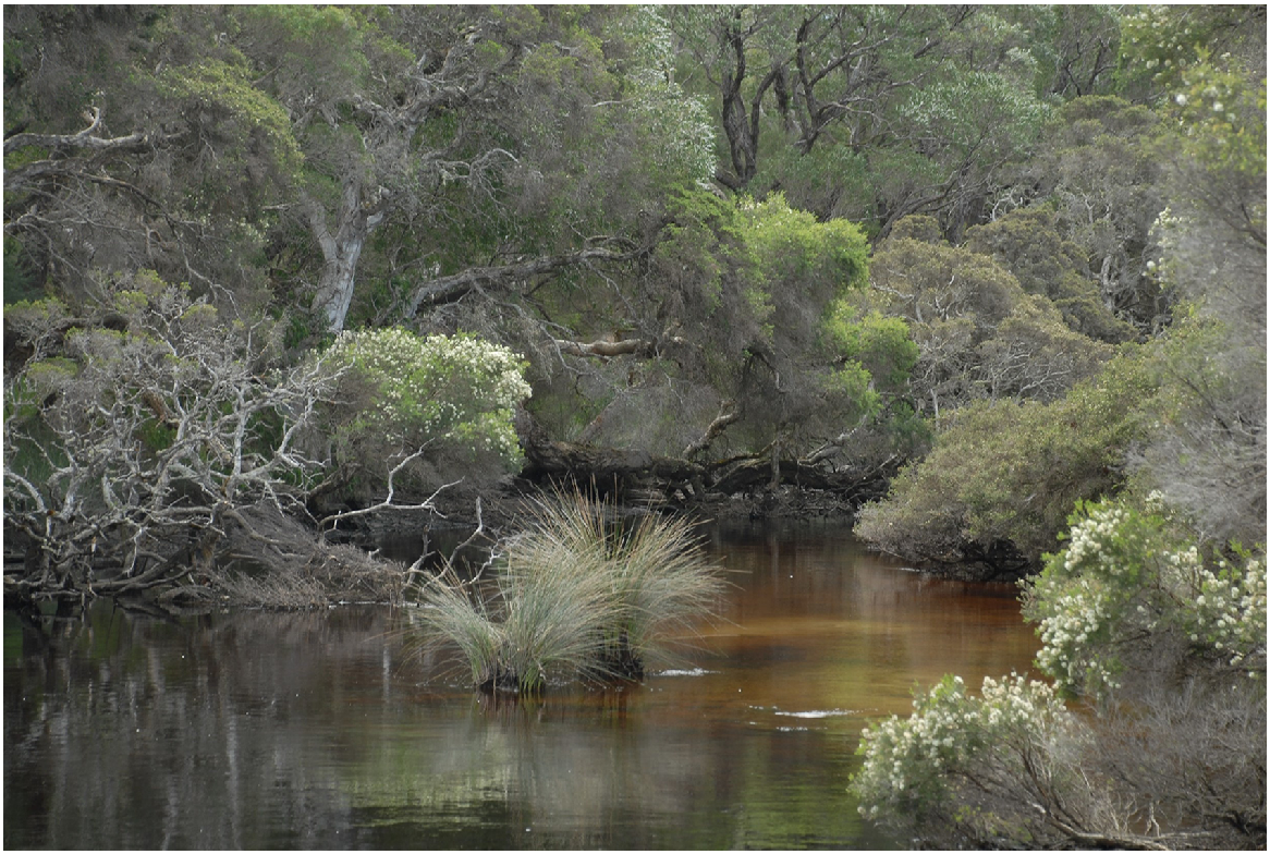
Part 11. The giant green serpent of Tyiurrtmiriity/Gardner Lake wetlands and Mt Gardner’s Merningar name – Dion Cummings, Lynette Knapp and Stephen Hopper. 19 January 2024
| SH: | Dion we were just talking about you and your Pop standing at the bridge over Gardner Creek on Two Peoples Bay Nature Reserve. What did he have to say to you? |
| DC: | Well he showed us the ti tree, the big ti tree (yoorl; Melaleuca preissiana, M. croxfordiae) on the side there before you get to the bridge, and you always wonder why it’s all knocked down? Pop used to tell us that’s where the big snake used to shed its skin. So you see it all knocked down yeah, they rubbed all them trees. And then he looked at the lagoons (Angove Lake) and said ‘that’s the woman’s tears’ (Miialyiin), and what we named it (Tyiurrtmiriity) for the lagoon on which we were standing (Gardner Lake). That’s the right name for it. Then he told me that the Two Peoples Bay people that humoured the snake or done their ceremonies and that was where that billabong was on the left-hand side (Gardner Creek). Going towards Two Peoples Bay you go over the creek, but you don’t know you think it’s just a creek going up but then it’s like being bitten out. It’s like a lagoon, like a billabong. |
| SH: | That’s between the bridge and the coast? |
| DC: | Yes. That’s where the Two Peoples Bay mob, one old bloke used to sing, and this snake used to come up. And the East Bay mob they used to go on the other side. On the left-hand side of Tandara goin’ down you see bullrushes where they did their ceremonies for that big snake. The story goes that a long time ago day turned into night. A big cloud came from out of nowhere and it was just black. And a big Wagyl (carpet snake/Rainbow Serpent) came through. She was pregnant. Then she dropped a lightning strike at the top of that hill where Tandara is and hit it. Everywhere the lightning strike happened that’s where she gave birth. That’s where the baby snake was born and rolled all the way down into the water. |
| SH: | Into the creek? |
| DC: | Yeah, that’s how he got there. |
| SH: | He was in Gardner Lake as well was he? |
| DC: | No. There were lots of big snakes. Been there for thousands of years. |
| LK: | Still are. |
| DC: | So when you are going down past Tandara going down the hill, you’ll see that little creek part. |
| SH: | Yes, on the left? |
| DC: | That’s where he would have come into the water. |
| SH: | So that’s where the Two Peoples Bay (mob) did their ceremonies? |
| DC: | No down on the other side. They (Yilberup mob) wouldn’t go on the other side because that’s the Two Peoples Bay mob. They’re two different people. Because Yilberup and Boyankaatup had a fight. That’s the way they lived. |
| SH: | Dion you’ve got a few further reflections on what your Pop told you about place names in Two Peoples Bay? |
| DC: | Yeah, well Mt Gardner that’s where the number 7 boomerang hit Boyankaatup and he became the shark. Pop always said it was Maardjitup Gurlin. Sounded like a ‘g’ or something. |
| SH: | Maardjitup Gurlin? |
| DC: | Gurlin yeah. Because he turned into the shark. Got hit with the number 7 (a boomerang fashioned in the shape of the numeral ‘7’; see Fig. 17). So that’s the pronunciation that basically goes with the story. |
| LK: | I think that’s the other name for the number 7 down here. |
| SH: | What is? |
| LK: | Gurlin yeah. |
| SH: | Ah. So it’s the maardjit’s boomerang? |
| DC: | Yeah. The boomerang that turned him into the shark. Because you know how they say he was a shark and then he got a boomerang? But no, when he was a shark then he got hit by a boomerang. That’s why the pronunciation, the story is around the other way. |
| SH: | Oh well that’s fantastic. So it’s Goorlin? Madjitup Goorlin? Wonderful. |
| DC: | I think for some it’s Gurlin yeah. |
| LK: | And Guling is what I call one of my cousins. I think I’m the only one that does it. I call her Guling. It means that person, or that important person. |
| SH: | So, it’s Maardjitup Gurlin and that’s for the whole hill? |
| DC: | That’s Mt Gardner. |
| SH: | That’s Mt Gardner so if we wanted to talk about the whole headland with all its granites? |
| DC: | The head part is Boyankaatup, the hilltop, but on the other side you’ll see on Yilberup, where that teddy bear ear is that you (LK) talk about, when he got hit in the stomach, the spear went through, so that’s where the end of the spear is. That rock formation underneath, that’s his stomach. |
| SH: | That’s his stomach? The big sheet rock you can see on the main peak (of Mt Manypeaks)? |
| DC: | That’s the thing that turned him into the stingray. So getting back to Pop, I remember him saying the one that we wrote down for the lagoons (Tyiurrtmiirity), that’s the right one for the snake. Yeah. And I remember him pointing at Mt Gardner and saying ‘Maardjitup Gurlin’. |
| LK: | But Popeye [Alf Knapp], when he mentioned that place name, he would never ever have thought about the big green snake either. He would have thought ’shark’, so it’s all the shark story. |
| DC: | Two different names. |
| LK: | That’s where it’s all comin’ in now. So the Maardjit story (for the rainbow serpent) belongs to people from inland. It’s not our story. Our Maardjit is a shark. |
Part 12. Naarup/Waterfall Beach, sea serpent and kylie/boomerang making – Dion Cummings and Stephen Hopper. 15 December 2022
| DC: | This is one of the main spots where, when we was kids, we used to go out swimmin’. And if the water was rough like this, my old Pop would be sitting on top of the rock. Keeping an eye on us, and light a fire, and sing a song to calm the water down, and the day would become just so good. |
| SH: | Would it? |
| DC: | Yeah. |
| SH: | So Alf Knapp sang a song in Noongar Language? |
| DC: | In Noongar Language. Dunno what song it was but yeah… I knew as soon as he made that fire, I knew that we would be alright. |
| SH: | He was just up behind us here, eh? Just on up there? |
| DC: | Yeah. Just on the rocks (between Naarup/Waterfall Beach and Little Beach). He was always sittin’ there and one day he said that he seen the big serpent. And he made us boys stand up and not look at the water. Because if we looked at the water, the serpent would have had us, so he ended up singing his own Noongar songs…I… I can’t remember it, but yeah that’s how he calmed the water down, the waves never flicked up no more, and yeah, it seemed to be alright. The day turned good. |
| SH: | Yeah. So the water serpent, was that the same one as at Nanarup? |
| DC: | No. It’s the one that’s over in Tyiurrtmiirity/Gardner Lake |
| SH: | Ah, that big fella. |
| DC: | Yeah. |
| SH: | He was down here? |
| DC: | He’s the one that controls this whole area. |
| SH: | So he was in the marine water here? |
| DC: | Yeah. He was in the water, yep. Yeah. So sea serpents, you get the fresh water and the salt water. |
| SH: | And you mentioned about boomerangs here? What’s the story? |
| DC: | Boyankaatup. There’s a story about how he got hit in the back with a (kylie/)boomerang and the boomerang stood in his back. Over in this water where these big trees (quararl, Eucalyptus angulosa, Fig. 20) are over here. This is one of the main boomerang trees where they make boomerangs for their tribes. This is the way they lived and all that. So with Boyankaatup gettin’ hit by the boomerang he ended up becoming a sacred part of their story about boomerang making on that corner over there. |
| SH: | On that corner. So that’s Eucalyptus angulosa. It’s the one with the flowers on it at the moment. Is that right? |
| DC: | Yep, yep, yep. Nice big thick carved wood, you know you carve it right down and dry it out, like you’d wet one end, what you’d do is you’d burn the same end at the same time. What it does is the two ends draw water into the middle and make it heavy in the middle. So the boomerang can go ‘round’ (spinning in the air signalled) and come back. So the two outsides are light, and the water-logged middle is where the water goes to, makes it heavier. It affects the balance of the boomerang I suppose. |
| SH: | Yeah. Is that where the main waterfall is? That cascade of rocks? Oh, it’s just up there, that’s right. Yeah, has that got any stories? |
| DC: | Uh, not that I know of anyways, no. |
| SH: | Ah. And behind us here you mentioned across the bay that the Manypeaks mob would make spears, eh? |
| DC: | Yeah. I know that Yilberup lived on that side (pointing to Mt Manypeaks). Boyankaatup threw the spear and hit him (Yilberup) straight through the stomach, so where the rock is, up top of the mountain, that’s the edge of the spear (Fig. 20). |
| SH: | The highest point? |
| DC: | Yeah. |
| SH: | Ah okay. Yeah, yeah. |
| DC: | That rock is supposed to be the edge of the spear. Like when he turned, he turned his guts inside out, and then became the stingray. So, over at the bottom of that hill, around Manypeaks, you’ll see spear-making trees, and you’ll actually see where they have been cutting them out. When he got speared by Boyankaatup he took the spear and that’s where the spears get made. Same as vice versa for Boyankaatup. He got hit by the boomerang, and that’s where the boomerangs get made. |
| SH: | So, this is boomerang Country (on Naarup/Waterfall Beach) and that’s spear (Country on Manypeaks). |
| DC: | Yeah. Shark mob (points to Naarup/Waterfall Beach) and Stingray mob (points across the bay to Yilberup/Manypeaks). |
| SH: | Yeah? |
| DC: | Yeah. |
| DC: | Lastly here at Waterfall Beach, on the other side of that big rock, the main rock that comes into the water. On the other side you see a cave, and it goes down into the water as well. It stretches along. And when you look inside the cave, you’ll see a couple of whale carvings (Fig. 20). |
| SH: | Whale carvings? |
| DC: | Yeah. |
| SH: | Fantastic. |
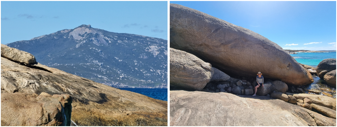
Part 13. Little Beach and Boyan/orphans plus giant spear sharpening rock – Dion Cummings and Stephen Hopper. 15 December 2022
| SH: | Now we’re just between Waterfall Beach and Little Beach. |
| DC: | Yep. |
| SH: | And this is quararl, Eucalyptus angulosa (Fig. 21). |
| DC: | Yep. One of the trees that Dad made boomerangs out of. The main thing is the water in the tree. If you burn both ends of the boomerang when you carved it out, to harden it up, to fire it you know, what you’d do is when you burn both ends of the boomerang, it makes the water go in the middle and balances the boomerang. Yeah, so when they fly it goes round then comes back. |
| SH: | Comes back? |
| DC: | Yeah. |
| SH: | Have you seen the old boys making boomerangs out of these? |
| DC: | I’ve seen one old bloke. They reckon I wasn’t born yet, but he was using the Medicine tree. The snottygobble (Persoonia longifolia). |
| SH: | Yeah. |
| DC: | Yeah, the medicine tree? He used to grab that out, and the root, he’d carve the root out into a boomerang. That’s why there’s none at the old reserve no more because old Grandfather Garnet Jones was the one that was making the boomerangs. |
| SH: | Which reserve are you talking about? The one in Albany (on Mt Melville)? |
| DC: | The one in Albany. See that old bloke was Nanna’s old cousin from up Meekatharra way (1000 km) north. |
| SH: | Ah, was he? |
| DC: | Yeah. But he ended up marrying Auntie Gail’s mother Nana Jock (Dorothy Yorkshire). Most of the medicine trees they reckon that he pulled out and then carved the boomerangs out of it, and the old Noongars at the reserve didn’t like it because that was their medicine. |
| SH: | Their medicine tree. Ah. |
| SH: | We’re down on the southern end of Little Beach now. Dion, you have a story about orphans? |
| DC: | Boyankaatup was actually born from one of the Seven Sisters, so she was pregnant with Boyankaatup. Chief Djimaalup took him in as his own child. Boyan means orphan in our lingo (language). So, when they used to find kids from deserts or they came from different Countries they was by themselves and their families were gone they’d stick them on the little waterhole just around the corner here (pointing north of Little Beach, Fig. 22). The test used to be the ocean. So if the ocean would grab them and take them they weren’t supposed to be here. If the ocean left them they’d come back up and be brought into this tribe here. |
| SH: | Oh really? |
| DC: | Yep. Part of the family (nodding). |
| SH: | So it’s a place for orphans as well? |
| DC: | Yeah. |
| SH: | How long would they leave the orphans in the pool? Just overnight? |
| DC: | About a week! And it’s up to the ocean serpent that flicks his tail or whatever. If they (the orphans) were chosen they’d go and live with the mob up top of here (behind Little Beach). |
| SH: | Let’s move to the central rock on Little Beach (Fig. 22). What’s its story? |
| DC: | Boyankaatup, before he threw the spear, he needed to sharpen it. In our black fellas ways, we used to carry a little rock around, and used to sharpen the spear, heads up. And before he threw the spear, that’s what Boyankaatup sharpened his spear on the spear sharpening rock, this rock here. |
| SH: | This giant one because he was a spirit man (Fig. 22)? |
| DC: | He threw the spear. And at same time, Yilberup threw the boomerang and then turned into the stingray and the Boyankaatup turned into the shark. Yeah. |
| SH: | So, giant spear sharpening rocks? |
| DC: | Yeah. Yep. |
| SH: | Great. |
DC affirms that this quararl (Eucalyptus angulosa) is the local kylie/boomerang tree at Little Beach. The bend where the aerial trunks run into the lignotuber below ground was sought after. LK also indicated the same species and parts were popular for making traditional hockey sticks at Bremer Bay. Inset shows buds, fruits and flowers with broad coppice leaf and slender mature leaf. S. D. Hopper main photo; inset Nathan McQuoid.
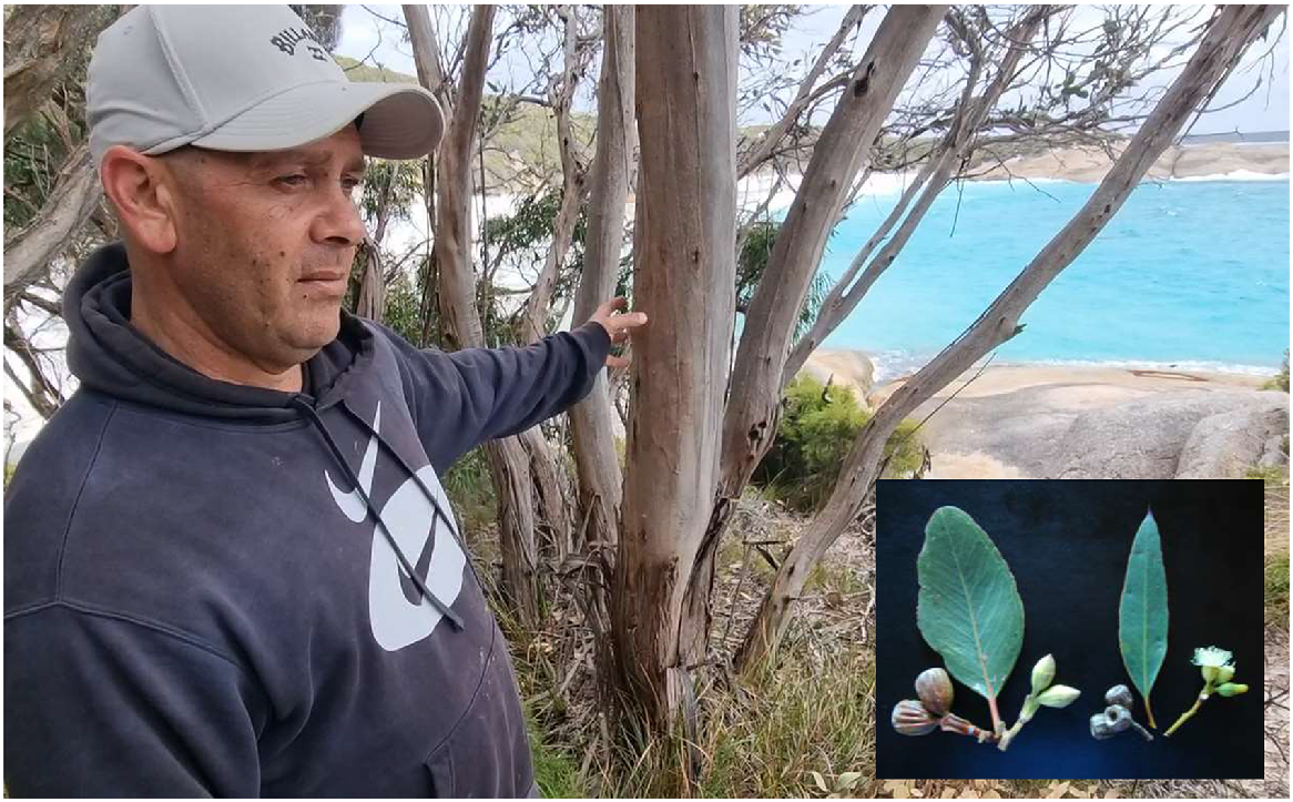
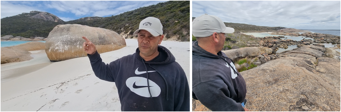
Part 14. Boyanup (orphan’s) pool and its use in recruiting young men into the Two Peoples Bay camp – Dion Cummings and Stephen Hopper. 15 December 2022
| SH: | We’ve just come around to the north, northeast maybe of Little Beach, Two Peoples Bay. And this is the orphan pool in front of us (Fig. 22). |
| DC: | Yeah. They used to stick the orphans here. They were boyans, we called them. So, it was a test with the ocean. If the ocean came, it would come completely over the rocks. So, if the ocean came over the rocks and took them, they weren’t meant to be here. If they were still here in a couple of days well, they would get taken up back to (the) Boyankaatup mob, the tribe up on the hill here. |
| SH: | And the main campground was up top there? |
| DC: | The main campground was up top here, yeah. The old main camp. So, they had to have been able to have everything, their traditional ways and stuff. |
| SH: | Yeah. Yeah. And you mentioned there’s all sorts of other stuff here. |
| DC: | Yeah, well, you’ll see, you’ll find petroglyphs. Probably even artefacts along the beach and all stuff like that. But a lot of grinding rocks. Especially in that group of rocks, just here. |
| SH: | Just there? |
| DC: | Yep. You wouldn’t realise it, but there’s rocks on rocks. And where you look there’s like little caves, so, yeah. |
| SH: | Where people have stored grinding stones and stuff? |
| DC: | Yeah. Sat in there. And you can see where they have been, a couple of them have been grinding and stuff, whatever. But this is the main spot they stuck the orphans as a test to see if they go up the hill, go into our mob. Or they go, wasn’t meant to be. See, (points to his right) this is a quiet day. |
| SH: | Quiet day, yeah. Yeah, you can see there’s hardly any vegetation on these rocks. It’s obviously hammered by the big swell. |
| DC: | Oh, yeah. |
| SH: | Great. Sorry. These were orphans, young fellas on their own, often had been. |
| DC: | Yeah. Well, their family probably got killed. Payback or things like that. And like being Aboriginal they knew exactly where, through stories, where to come. You know what I mean. So, if they heard about Boyankaatup or boyan, being orphaned, and he’s a part of one of the Seven Sisters, they knew to down come this way, down here. |
| SH: | To come. And have a chance of being adopted. |
| DC: | Yep. Have a chance of being adopted. |
Part 15. Poikeclerup Hill – Djimaalap’s camp, views east to Two Peoples Bay and Boyanbelokup/Rock Dunder – Dion Cummings and Stephen Hopper. 15 December 2022
| DC: | On Poikeclerup, Djimaalap used to camp up here so he could oversee Boyankaatup, Tandara, and Yilberup the way they used to live, so he could make sure they were right living off the land and doing the right thing. Usually he’d camp up at the rock, straight up in the bush there. That’s the old Djimaalap, one of Djimaalap’s camps. And the other camp is on top of Mount Clarence. The other of Djimaalap’s camps is on top of Mount Clarence. |
| SH: | There’s two main camps. |
| DC: | Yep. |
| SH: | So, it’s that rock you can just see a little bit of. |
| DC: | And he used to turn into the noisy scrub-bird, that was his totem. Yep. So, they didn’t know who he was so, he used to fly from here all the way to Two Peoples Bay to keep an eye on them. Yes. |
| SH: | We’ve got a nice view of Two Peoples Bay. Yeah. You can see. Manypeaks is hidden by rain today, hey? |
| DC: | Yeah. Yep. Yeah, you can see the sand dunes (Tyiurrtyaalup) where all the rocks were where Boyankaatup picked up all the rocks and turned it into normal sand. So, all the rocks ended up at Betty’s Beach (Yiilangarup), because they were thrown. And same as the other bloke. At the bottom of Mount Manypeaks the sand dunes, that’s where he picked up his rocks and threw them. |
| SH: | Ah. Yeah. With the big fight. And that made the sand dunes? |
| DC: | That made the sand dunes. Yeah. |
| SH: | Yes. A fine view. I often wondered, that’s called Boyanbelkup/Rock Dunder, that island to the right there (Fig. 23). Do you know anything about that? |
| DC: | I’ve heard yarns about the old traditional ways of that. Them going on their walks and swimming to that island to get shells. |
| SH: | Really? |
| DC: | Yeah. To get that special shell as part of the Shell People initiation. |
| SH: | Is it? |
| DC: | Yeah. |
| SH: | So, you think abalone or something like that? |
| DC: | I don’t know. They reckon there was a special shell on there. And they knew if you get the shell, they knew that you’d been there. So, when you go back the oldies knew that you’d been to that island, and you’d done your traditional initiation. |
| SH: | How about that. So, that was part of the male initiation. |
| DC: | Male initiation. Yeah. You’d have to be a good swimmer to swim out there. |
Views to the east-southeast from Poikeclerup Hill (top) and Nanarup Beach showing Boyanbelokup/Rock Dunder’s position relative to Cape Vancouver and the rest of Maadjitup Gurlin/Mt Gardner. In this profile Boyanbelokup/Rock Dunder is the ankles/belok of Boyankaatup when he tripped and fell face forward with the kylie/boomerang in his back forming the summit of Maardjitup Gurlin/Mt Gardner. Photos S. D. Hopper.
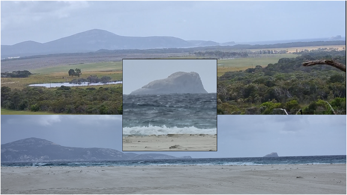
Part 16. West end of Kaiupgidjukgidj/Moates Lake and mussel aquaculture – Dion Cummings, Stephen Hopper and Sarah Comer (ecologist, Department of Biodiversity, Conservation and Attractions). 5 March 2024
| SH: | We’re at the west end of Moates Lagoon or Kaiupgidjukgidj as we now know it. And Dion what are you looking at? |
| DC: | I’m just looking at how the bases (of wardaruk/jointed sedge Machaerina articulata) have been carved out through the years (Fig. 24). The old black fellas would have carved it out and shoved the dirt in, you know, so the mussels could clam up and against the trunk. A bit like a farming game (Pascoe 2014), mussels, in the water. So, when the water goes out, they can collect them. |
| SC: | A bit like that one there? |
| DC: | Yeah. |
| SC: | And underneath that one? |
| DC: | Yeah, you see where they’ve been scratching around, you know. Even fish traps and that as well. |
| DC: | Yeah. You can see that’s one of the ways they farmed the mussels, anyway, just dig out the bottoms and then the mussels would clam up to the plant. And then just go and collect a feed when they want. |
| SH: | Gives them a bit of protection, yeah? |
| DC: | Awesome. So, you can see that one. Second one, you can see all the mussels down the bottom. |
| SC: | Yep. |
| SH: | Oh, yeah, I can now, from here, yeah. There’s a shell. |
| DC: | Even in the water over there. It’s awesome. |
| SH: | And Sarah (Comer), do you know what mussel it is? |
| SC: | No, I’m not sure. We need to check that manuscript but there’s two freshwater mussels here. |
| SH: | Is there? |
| SC: | One’s the clustering one. And then this is the bigger, solitary one (Westralunio inbisiKlunzinger et al. 2022). |
| DC: | Yeah. So, I’d say that one that’s open here is the other one. Just see, see a different colour on it? |
| SC: | Yeah. |
| DC: | It’s a bit like the pipi (Donax (Plebidonax) deltoids), but a bigger one. |
| SC: | Pipi, yeah, yeah. |
| SH: | Yep. Thanks. |
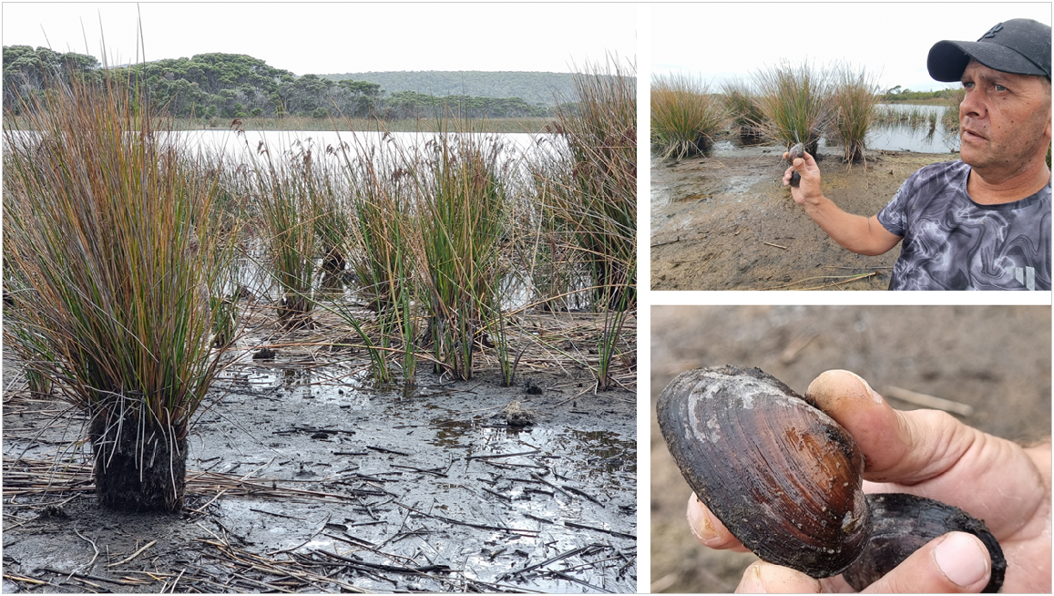
Declaration of funding
This paper is part of the Walking Together project conducted by Noongar families and The University of Western Australia (UWA) in partnership with South Coast Natural Resource Management, supported by Lotterywest, UWA’s Research Priority Fund, and a startup grant from Janet Holmes à Court. This research would not have been possible without the invaluable assistance of SDH’s salary paid for by The University of Western Australia.
Acknowledgements
This paper is written to honour and respect Noongars (Aboriginal peoples of south-west Australia), particularly the Knapp family ancestors and custodians of Country, past, present, and future. We are grateful to all who contributed to the collective kaatidjin/knowledge shared herein. The oral history interviews were undertaken under the University of Western Australia’s (UWA) Human Ethics Approval RA/4/1/6836. This approval broadly follows the AITSIS Code of Ethics for Aboriginal and Torres Strait Islander Research 2022 (aiatsis.gov.au/research/ethical-research/code-ethics). Our UWA colleagues on the Walking Together project provided invaluable discussion and support, including Dr Alison Lullfitz, Catherine Vasiliu, Susie Cramp, Ursula Rodrigues, Rocio Almuna, Anna Ischenko, Genevieve Carey, and several other students. Transcriptions of oral history recordings were first drafted by Annabelle Atkins, Susannah Cramp, Hannah Demerise, Steve Hopper, Anna Ischenko, Sonja Pascho, and Beau Ziere, to whom we are grateful. We have benefitted by ongoing discussions with many Elders, family, and friends. We thank them all. Dr Alison Lullfitz is thanked for critical comment on the manuscript. Reviewers Professor Peggy Fiedler and Dr Denis Saunders made many helpful suggestions for major revisions needed on the original manuscript. Indeed, Professor Fiedler’s contributions were so substantial that she was invited to join the writing team as a coauthor. Dr Denis Saunders provided strong editorial support in seeing this paper through to publication. We are grateful for his approval to use his words in the second introductory paragraph.
References
Bracknell C (2017) Conceptualizing Noongar Song. Yearbook for Traditional Music 49, 92-113.
| Crossref | Google Scholar |
Bradshaw SD, Dixon KW, Lambers H, Cross AT, Bailey J, Hopper SD (2018) Understanding the long-term impact of prescribed burning in mediterranean-climate biodiversity hotspots, with a focus on south-western Australia. International Journal of Wildland Fire 27, 643-657.
| Crossref | Google Scholar |
Chatfield G, Saunders DA (2024) History and establishment of Two Peoples Bay Nature Reserve. Pacific Conservation Biology 30, PC24004.
| Crossref | Google Scholar |
Cramp S, Murray S, Knapp L, Coyne H, Eades A, Lullfitz A, Speldewinde P, Hopper SD (2022) Overview and investigation of Australian Aboriginal lizard traps. Journal of Ethnobiology 42, 400-416.
| Crossref | Google Scholar |
Danks A (1997) Conservation of the Noisy Scrub-bird: a review of 35 years of research and management. Pacific Conservation Biology 3, 341-349.
| Crossref | Google Scholar |
Dempster A (1865) Journal of A. Dempster on a trip north of Esperance Bay. Perth Gazette and West Australian Times Friday 10 November 1865, p. 3.
| Google Scholar |
Ferguson WC (1987) Mokare’s domain. Canberra Times 27 October 1987, p. 32.
| Google Scholar |
Gibbs M (2003) Nebinyan’s songs: an Aboriginal whaler of south-west Western Australia. Aboriginal History 27, 2-15.
| Google Scholar |
Haley NC (1849–1853) Journal, Charles W. Morgan (Ship: 1841) Log 145. Available at https://research.mysticseaport.org/item/l030775/#55-56 [Accessed 26 January 2024]
Helms R (1896) Report of the elder expedition anthropology. Transactions of the Royal Society of South Australia 16(Ptiii), 237-332.
| Google Scholar |
Hopper SD (2009) OCBIL theory: towards an integrated understanding of the evolution, ecology and conservation of biodiversity on old, climatically buffered, infertile landscapes. Plant and Soil 322, 49-86.
| Crossref | Google Scholar |
Hopper SD (2018) Natural hybridization in the context of Ocbil theory. South African Journal of Botany 118, 284-289.
| Crossref | Google Scholar |
Hopper SD (2023) Ocbil theory as a potential unifying framework for investigating narrow endemism in Mediterranean climate regions. Plants 12, 645.
| Crossref | Google Scholar | PubMed |
Hopper SD, Silveira FAO, Fiedler PL (2016) Biodiversity hotspots and Ocbil theory. (Marschner Review). Plant and Soil 403, 167-216.
| Crossref | Google Scholar |
Hopper SD, Lambers H, Silveira FAO, Fiedler PL (2021) OCBIL theory examined: reassessing evolution, ecology and conservation in the world’s ancient, climatically buffered and infertile landscapes. Biological Journal of the Linnean Society 133, 266-296.
| Crossref | Google Scholar |
Hopper SD, Harvey JM, Hopkins AJM, Moore LA, Smith GT (2024) Plant diversity on the edge: floristics, phytogeography, fire responses, and plant conservation of Two Peoples Bay Nature Reserve in the context of OCBIL theory. Pacific Conservation Biology 30, PC24024.
| Crossref | Google Scholar |
Klunzinger MW, Whisson C, Zieritz A, Benson JA, Stewart BA, Kirkendale L (2022) Integrated taxonomy reveals new threatened freshwater mussels (Bivalvia: Hyriidae: Westralunio) from southwestern Australia. Scientific Reports 12(1), 20385.
| Crossref | Google Scholar | PubMed |
Lullfitz A, Dortch J, Hopper SD, Pettersen C, Reynolds RD, Guilfoyle D (2017) Human niche construction: Noongar evidence in pre-colonial Southwestern Australia. Conservation and Society 15, 201-216.
| Crossref | Google Scholar |
Lullfitz A, Byrne M, Knapp L, Hopper SD (2020) Platysace (Apiaceae) of south-western Australia: silent story tellers of an ancient human landscape. Biological Journal of the Linnean Society 130, 61-78.
| Crossref | Google Scholar |
Lullfitz A, Pettersen C, Reynolds R, Eades A, Dean A, Knapp L, Woods E, Woods T, Eades E, Woods S, Dortch J, Guilfoyle D, Hopper SD (2021) The Noongar of south-western Australia: a case study of long-term biodiversity conservation in a matrix of old and young landscapes. Biological Journal of the Linnean Society 133, 432-448.
| Crossref | Google Scholar |
Lullfitz A, Knapp L, Cummings S, Woods J, Hopper SD (2023a) Talking Mungee – a teacher, provider, connector, exemplar: what’s not to celebrate about the world’s largest mistletoe, Nuytsia floribunda. Plant and Soil
| Crossref | Google Scholar |
Lullfitz A, Woods J, Knapp L, Cummings S, Hopper SD (2023b) ‘WA’s Christmas tree’: what mungee, the world’s largest mistletoe, can teach us about treading lightly. The Conversation Available at https://theconversation.com/was-christmas-tree-what-mungee-the-worlds-largest-mistletoe-can-teach-us-about-treading-lightly-205568.
| Google Scholar |
Mitchell M (2013) Report of a Heritage Assessment of the Quaranup (Vancouver) Peninsula, Albany, Western Australia: phase II. A report prepared for the Albany Heritage Reference Group Aboriginal Corporation and South Coast Natural Resource Management. Applied Archaeology Australia, Albany, Western Australia.
Moore GF (1842, reprinted 1884) ‘A descriptive vocabulary of the language in common use amongst the Aborigines of Western Australia; with copious meanings, embodying much interesting information regarding the habits, manners, and customs of the natives, and the natural history of the Country.’ (William S. Orr and Co.: London, UK)
Muir G (2020) The Beat Of Ursus - WOW Eco Tours The BHE. Students activating whale-calling rock at Walpole. Available at https://www.youtube.com/watch?v=StjEnFYp-fU [Accessed 10 March 2024]
Nind S (1831) Description of the natives of King George’s Sound (Swan River Colony) and adjoining Country. Journal of the Royal Geographical Society of London 1, 21-51.
| Crossref | Google Scholar |
Oldfield A (1865) On the Aborigines of Australia. Transactions of the Ethnological Society of London 3, 215-298.
| Crossref | Google Scholar |
Palci A, Hutchinson MN, Caldwell MW, Scanlon JD, Lee MSY (2018) Palaeoecological inferences for the fossil Australian snakes Yurlunggur and Wonambi (Serpentes, Madtsoiidae. Royal Society Open Science 5, 172012.
| Crossref | Google Scholar | PubMed |
Rodrigues U, Lullfitz A, Coyne L, Dean A, Eades A, Flowers E, Knapp L, Pettersen C, Woods T, Hopper SD (2022) Indigenous knowledge, aspiration, and potential application in contemporary fire mitigation in Southwest Australia. Human Ecology 50, 963-980.
| Crossref | Google Scholar |
Scanlon JD (1995) First records from Wellington Caves, New South Wales, of the extinct madtsoiid snake Wonambi naracoortensis Smith 1976. Proceedings of the Linnean Society of New South Wales 115, 233-238.
| Google Scholar |
Silveira FAO, Fiedler PL, Hopper SD (2021) OCBIL theory: a new science for old ecosystems. Editorial Biological Journal of the Linnean Society 133, 251-265.
| Crossref | Google Scholar |
Thieberger N (2017) Digital Daisy Bates. Available at http://bates.org.au
Footnotes
2 Since colonisation, numerous government laws, policies and practices resulted in the forced removal of generations of Aboriginal and Torres Strait Islander children from their families and communities across Australia. Thousands of children were forcibly removed by governments, churches and welfare bodies to be raised in institutions, fostered out or adopted by non-Indigenous families, nationally and internationally. They are known as the Stolen Generations. More information available at https://aiatsis.gov.au/explore/stolen-generations, accessed 19 April 2024.
3 Tyirnduyalaba transliterally means ‘white Earth become’ (see von Brandenstein 1988, pg vii). Tyiurrt means sandy or blondy, and alludes to the ‘ancestral hero involved in the creation of the southern coastline’ (von Brandenstein 1988, pg 113).