

The relationship between the presence of people, fire patterns and persistence of two threatened species in the Great Sandy Desert
Rachel Paltridge A B * , Yalti Napangati C , Yukultji Ward C , Johnny Nangagee C , Mantua James C , Raymond Olodoodi C , Nanyuma Napangati C , Stephen Eldridge D , Andrew Schubert D , Edward Blackwood C E and Sarah Legge F G
A
B
C
D
E
F
G
Abstract
Indigenous Australians who lived in the desert used fire for many purposes. The interruption of these practices following colonisation, and the spread of invasive predators, coincided with massive faunal loss. Many extant species are still threatened by invasive predators and changed fire regimes. The study indicates that reinvigoration of traditional fire practice could help conserve declining species. The work presented here arises from a collaboration of scientists and Pintupi people (Traditional Custodians of the Kiwirrkurra Indigenous Protected Area, IPA). Some Pintupi co-authors grew up with a traditional nomadic lifestyle, and they include members of the Pintupi Nine, the last Pintupi people to walk out of that nomadic life, joining the Kiwirrkurra community in 1984.
To understand how traditional burning practices affect two threatened and culturally significant species: ninu (greater bilby, Macrotis lagotis) and tjalapa (great desert skink, Liopholis kintorei), on the Kiwirrkurra IPA.
We used satellite imagery to examine fire regimes in a 40-year time series (1980–2020) that includes transitions of people leaving, or returning, to different parts of the IPA. We collated information about traditional fire practices shared by Kiwirrkurra co-authors. Finally, we examined how ninu and tjalapa are affected by people presence and the fire regime.
People influenced the fire regime by burning while hunting, by increasing the number of fires, decreasing their size, shifting the fire season (towards cooler months), and increasing the extent of long-unburnt vegetation. This regime reduced the fire extent after prolonged, widespread rainfall. Hunters have been active in the Kiwirrkurra community over the past 35 years, and fire patterns resemble those in the 1950s before the desert was depopulated. Under this fire regime, both bilbies and great desert skinks have persisted over 20 years of monitoring, with no large fires occurring since 2002. By contrast, they have disappeared from surrounding unmanaged parts of the landscape.
We suggest traditional burning helps ninu and tjalapa by increasing food resources in the fresh firescars and reducing vulnerability to predators by maintaining more mature habitat.
We support the use of traditional foot-based hunting fires in accessible hunting areas. Where prescribed burning is used for conservation, we recommend burns that are the width of typical hunting fires (~100−200 m wide). After significant rainfall events, burning should occur as grasses cure so that fuel continuity can be broken up, and extensive fires prevented.
Keywords: bilby, ethnobiology, fire, great desert skink, Indigenous land management, threatened species, two-way science.
| Short summary and translation |
| Kiwirrkurra Traditional Owners use fire as an important tool to assist the harvest of bush meats and promote growth of favoured food plants. Forty years of firescar mapping across managed and unmanaged areas of Kiwirrkurra country show that where traditional burning has been maintained, populations of threatened species (bilby and great desert skink) have persisted, while disappearing from the surrounding landscape. |
| Pintupi summary: Yanangu Kiwirrkurra tjana kututja waru kutjani panya kukaku an yukiri mangarri puutjinuku yurrunpa tjintu nganti yarra-paluda yirrititja tjutangku. 40 yiya panya waru yilkarri katunguru nintini Ninu anta Tjalapaku yaaltji-wana Yanangu tjutangku yankula kuka an warukitjangkulpi nyanganyi ngurra Tjalapaku. |
Introduction
Everyday walking, with tjangi [firestick], burning. Coolamon, firestick, warna [digging stick]. [Yukultji Ward]
Fire is a key disturbance process worldwide, occurring at varying frequencies in diverse ecosystems (Pausas and Ribeiro 2013). Fire is a particularly prominent feature of Australian deserts (Morton et al. 2011) where the vegetation is often dominated by spinifex (Triodia spp.), a group of perennial hummock grasses that are slow to decompose and highly flammable. Fires therefore spread easily once sufficient spinifex biomass has accumulated to allow fire to carry between hummocks (Allan and Southgate 2002; van Etten and Burrows 2018; Ruscalleda-Alvarez et al. 2023). Heavy rainfall events can also encourage fire spread by stimulating a carpet of ephemeral annual grasses and forbs that provide fuel continuity even if spinifex hummocks are small and widely spaced (Verhoeven et al. 2020). Fires are started by lightning strikes (Kuleshov et al. 2006; Russell-Smith et al. 2007) and people (Edwards et al. 2008; Pausas and Keeley 2009).
Indigenous Australians have used fire in Australian deserts for millennia, to manage resources, communicate, protect sites from wildfire, and generally look after Country (Gould 1971; Kimber 1983; Lowe 2002; Bird et al. 2005; Burrows et al. 2006; Pike 2008).
My father used to go hunting and do burning in the bush. That was the land management for the bush people, looking after the land. Right spinifex, right weather and right season, they used to light them in the right season. Because they had to look after the land properly. Because too much wildfire might come out. That’s why they used to burn the bushfire. To keep the land just lovely, and equal. Just good way. [Johnny Nangagee]
Studies of pre-colonisation fire regimes in widely separated geographic locations such as the Great Sandy Desert, Gibson Desert and Great Victoria Desert have shown that Indigenous people had strong effects on local fire regimes. People vastly increased the ignition rate and extended the fire season from hot to cooler months, creating fires that were much smaller in extent that contributed to a fine-scale seral mosaic. These burning practices moderated the fire regime that would otherwise be determined primarily by rainfall patterns (Burrows et al. 2006; Burrows and Chapman 2018; Blackwood et al. 2022). The degree of human influence on fire regimes may have varied across space and time; traditional fire practices were probably not used intensively or consistently across every part of the deserts (Kimber and Friedel 2015).
Following European colonisation, desert Indigenous people left their nomadic lifestyle, moving into missions, pastoral stations, and other settlements, mostly through the first half of 1900s, but as late as the 1980s (Long 1989). As the nomadic lifestyle diminished, traditional fire practices lessened and desert fire regimes became dominated by extensive fires (Burrows et al. 2006; Turner et al. 2011; Blackwood et al. 2022).
Australian desert fires are now among the most extensive in the world, regularly exceeding one million hectares (Edwards et al. 2008; Turner et al. 2011). These very extensive fires usually burn after widespread, heavy rainfall events that occur irregularly (every 5–30 years; Van Etten 2009). Although some argue that traditional hunting fires can maintain a fine-scale mosaic of different aged vegetation even during periods of high regional fire risk following above-average rainfall (Bliege Bird et al. 2012), others have reported that anthropogenic burning cannot contain the spread of extensive wildfires after widespread extreme rainfall events that trigger fuel accumulation (Kimber and Friedel 2015; Wright et al. 2021).
The exodus of people from the deserts coincided with the decline of mammal populations from arid and semi-arid Australia (Burbidge et al. 1988; Burbidge and McKenzie 1989). Desert mammal extinctions began in the second half of the 1800s, accelerating between 1930 and 1950, as the human diaspora neared completion (Finlayson 1961; Woinarski et al. 2019).
Changes in fire regimes caused by the loss of traditional fire practices in these decades may have contributed to mammal extinctions. Extensive fire homogenises vegetation structure and food availability over large areas, potentially reducing habitat quality for some species (Bolton and Latz 1978; Burbidge et al. 1988). Extensive fire also removes cover at scales much larger than most animal movements, and this lack of cover can increase the vulnerability of those animals to predators (Doherty et al. 2022). In addition to the native predators present, by the mid-1900s, both cats (Felis catus) and foxes (Vulpes vulpes) were established over the Australian desert (Abbott 2008; Fairfax 2019). These introduced predators are responsible for most of the modern Australian mammal extinctions; in the deserts, 60% of the species present at the time of European colonisation are now extinct (Woinarski et al. 2015). Correlative and experimental evidence has shown that predation pressure from cats and foxes can increase after fire, and that these effects may be accentuated in more open habitats such as deserts (Lundie-Jenkins 1993; Short and Turner 1994; Hradsky 2020; Doherty et al. 2022; Moore et al. 2024; but see Doherty et al. 2024).
As well as the extinctions, many other desert species experienced marked range contractions during this period of ecological change, and they continue to decline (Burbidge and McKenzie 1989; McKenzie et al. 2007; Woinarski et al. 2015). Examples include the greater bilby (Macrotis lagotis) and great desert skink (Liopholis kintorei). Both species have suffered significant range contractions in their continental distributions and now exist as highly fragmented, remnant populations (Department of Climate Change, Energy, the Environment and Water 2023; Indigenous Desert Alliance 2023). Fire regime changes are believed to threaten both species, by affecting the availability of key food resources (Southgate and Carthew 2007) and increasing vulnerability to cats and foxes (Moore et al. 2015; Department of Climate Change, Energy, the Environment and Water 2023; Indigenous Desert Alliance 2023; Geyle et al. 2024a, 2024b; Moore et al. 2024).
Pintupi people were one of the last desert groups to leave their nomadic lifestyles; 160 people were recorded emigrating east to settlements in the Northern Territory between 1956 and 1966 (Long 1989). In 1984, the last family (the Pintupi Nine) was found near Wilkinkara (Lake Mackay) and persuaded to join relatives in the newly established Kiwirrkurra community (Long 1989). Some of this family group are alive today, and along with other older Pintupi people who were born and grew up on country in earlier years, they have direct experiential knowledge of pre-contact nomadic lifestyles and desert ecology. The oldest people witnessed the loss of desert mammal species that were still present when they moved away from their country in the 1960s, but had ‘finished up’ by the time people returned to establish the Kiwirrkurra community in the 1980s. Species such as the jajirti (western quoll, Dasyurus geoffroii), wayurta (brush-tailed possum, Trichosurus vulpecula), and mala (rufous hare-wallaby, Lagorchestes hirsutus) were well known to people born in the bush in the 1940s and 1950s (Yuyuwa Nampitjinpa, pers. comm., June 2020; Nanyuma Napangati, pers. comm., April 2021), but were not seen by Pintupi who grew up on country in the 1970s and 1980s (Yukultji Ward and Yalti Napangati, pers. comm., April 2021). As well as these species losses, Kiwirrkurra residents have seen changes to the distribution of tjalapa (great desert skink) and ninu (greater bilby) during their lifetimes (Nanyuma Napangati, pers. comm., April 2021).
In addition to these personal testimonies of changes to country, the effects of traditional burning practices on fire regimes are captured in a series of aerial photographs from 1953 over a region that encompasses the eastern half of our study area (Burrows et al. 2006). These photographs show that people created a fine-scale patchwork of many small fires (averaging 64 ha in size), and that 22% of the area had burnt within the 5–6 years prior to 1953. Burrows et al. (2006) then used satellite imagery, which first became available in the 1970s, to trace changes in the fire regime from the 1950s through to 2000. They found that by the 1970s, the fine-scale mosaic produced previously by Pintupi living on country was being erased and replaced by a coarser grain. By 1981, 87% of the area had been recently burnt and the mean size of burnt patches had increased over 800-fold, from ~60 to 50,000 ha. This was a result of the extensive fires that occurred throughout central Australia after the exceptional rainfall in 1974–75.
Although much of Pintupi Country was left vacant and unmanaged for a 25-year period (1960–84), there has been a dynamic movement of people out of and into various parts of the area over the past 40 years. As well as the departure of the Pintupi people from near Wilkinkara in 1984, there was a period of intense reconnection elsewhere on the IPA when the Kiwirrkurra community was established in the same year, and when families returned to country at Nyinmi outstation from 1990 to 2000. Reconnection allows burning practices, especially those associated with hunting, to be restored (Bliege Bird et al. 2012). Opportunities for accessing and burning away from the community and outstation have also increased since the Kiwirrkurra Indigenous Protected Area (IPA) was dedicated in 2014, and the Ranger program was initiated. During these 40 years of varying connection to country in different parts of the Kiwirrkurra IPA, the distributions of ninu and tjalapa have changed; these changes have been quantified through a series of surveys conducted between 2000 and 2021.
Here we examine the relationships between Kiwirrkurra people, fire regimes and the persistence of threatened, culturally significant species. We use satellite imagery to examine changes in fire regimes across the Kiwirrkurra IPA in a 40-year time series (1980–2020) that includes transitions of people leaving from, or returning to, different parts of the IPA. We explore the influence of these transitions on the fire regime (using the same fire regime attributes as reported by Burrows et al. 2006), while accounting for variation in antecedent rainfall and previous fire extents. We also compare the fire regimes as evidenced by satellite imagery to information about traditional fire practices shared by Kiwirrkurra co-authors who were on-country, living a traditional lifestyle, until the 1980s. This information (primarily from Pintupi women’s perspective) adds to fire knowledge previously collated from interviews with Pintupi men (Burrows et al. 2006). Finally, we examine the patterns of persistence of two threatened and culturally significant species, ninu and tjalapa, in relation to people presence and the fire regime, at long-term monitoring sites across the Kiwirrkurra IPA. The purpose of this work is to inform management to ensure the continued survival of ninu and tjalapa on the Kiwirrkurra IPA, and potentially in other parts of their distributions, where they are cared for by other Traditional Custodians.
Poor thing ninu. We used to dig for ninu for meat a long time ago. We used to go and look at every burrow to check for ninu, in the winter time. We had to dig right down deep to catch a ninu. There were lots of ninu at Nyinmi in those days. We used to put the white bilby tail tips in our hair to make us look pretty. Old Men put the tails in their beards. This is our law and gave us special powers. [Nanyuma Napangati]
Methods
Study area
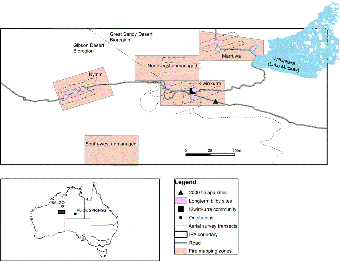
The Kiwirrkurra Indigenous Protected Area (IPA) is located 700 km west of Alice Springs in eastern Western Australia (Fig. 1). It lies at the intersection of the Great Sandy Desert and Gibson Desert. The IPA encompasses 42,857 km2 of predominantly spinifex hummock grassland on red sandy dunes and swales, but also features salt lakes and a series of low rocky ranges and outcrops. Built roads are limited to an east–west road connecting Alice Springs with the Pilbara, and a northern road that passes the western end of Wilkinkara (Lake Mackay) and continues to Balgo. There is a network of hunting tracks within 50 km of Kiwirrkurra, but beyond this area access is limited to driving vehicles off-track or travelling by helicopter. Kiwirrkurra is now the only permanently occupied settlement on the IPA, with a population of ~150 people, but there are several unoccupied outstations.
Map showing the main tracks, the community, and outstations of the Kiwirrkurra IPA; the locations of the five zones, ninu (pink circles) and tjalapa (black triangles) monitoring sites, and aerial survey routes (dashed lines). The inset shows the Kiwirrkurra IPA in Western Australia. The fine dotted line is the boundary between the Great Sandy Desert and Gibson Desert bioregions.
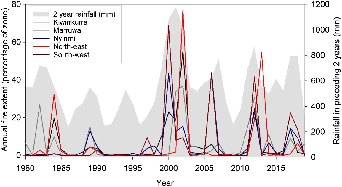
The area has a hot, dry climate with a mean annual rainfall of 280 mm, and high interannual variability. Rain can occur in any month of the year but December to March are generally the wettest months, with short, scattered rainfall events associated with thunderstorms or tropical cyclones. Rainfall is a primary driver of fire extent in spinifex deserts (Turner et al. 2011; Ruscalleda-Alvarez et al. 2023), and we needed to account for it in analyses. We sourced daily rainfall data from SILO interpolated datasets (see https://www.longpaddock.qld.gov.au/silo/), and summed this into annual totals, after modifying the definition of year to run from April to March, and thus align with rainfall seasonality (and fire seasonality, see below). Over the 40-year time series, there were several heavy rainfall periods, where >700 mm of rainfall fell over a 2-year period (Fig. 2).
The annual fire extent (percentage of zone burnt) for each of the five zones (shown in different coloured lines), with a grey backdrop that shows the cumulative rainfall of the preceding 2 years (mm). Fire extent is highest after large rainfall events (e.g. 2000–02; 2011–12). Note that during high fire-extent episodes, the fire extents for one or both unmanaged zones (north-east and south-west) are the highest.
We used satellite imagery to map each year’s fire activity from 1980 to 2020, in five large ‘zones’ (each 155,000 ha) of the Kiwirrkurra IPA (Fig. 1). Three of the zones had varying levels of human presence during the study period: Kiwirrkurra was unoccupied for the first few years, then continuously occupied by at least 100 people from 1984 until present, except for the entire evacuation of the community from March 2001 to August 2002 because of flooding. Marruwa was occupied by a single nomadic family, the Pintupi Nine, until they moved to the Kiwirrkurra community in October 1984. At Nyinmi, people lived a nomadic lifestyle until c. 1960. They returned to live at the outstation there from 1990 to 2000, but the outstation has not been inhabited since then apart from the occasional ranger camping trip. Two additional zones (north-east and south-west) have not had any human presence or visitation during the study period and were included as control areas.
The five zones are all dominated by spinifex dunefields but there are wider areas of sandplain (also with a spinifex ground layer) in the Kiwirrkurra and Marruwa zones. The Kiwirrkurra zone also contains an area of low quartzite ranges (Pollock Hills). The Marruwa zone includes a narrow section of the vast salt lake Wilkinkara (Lake Mackay), as well as a series of claypans in the middle of the zone.
Fires were mapped using Landsat images downloaded from the United States Geological Survey (see https://earthexplorer.usgs.gov/). Most images had a resolution (pixel size) of 30 m, except for those captured prior to mid-1982, which had a resolution of 60 m. For each year, at least two cloud-free images were downloaded; one from late summer (February–March) and the other from late winter (August–September), to allow us to map cool-season (April–August) and hot-season (September–March) fires separately. Fire scars were mapped by creating difference images (comparing images taken in two consecutive periods). Burnt areas were visualised using two burn indices, namely, the normalised burn ratio (NBR, (near infrared − short-wave infrared) ÷ (near infrared + short-wave infrared), and the near infrared band (dB4 = Band 4 in Landsat 5 and 7) (Key and Benson 1999). Fire scars were mapped using interactive supervised classification; training polygons were situated within and outside of visible fire scars and used to automate mapping over the rest of the raster image. Rasters were converted to vector format, with burnt polygons manually checked against the original Landsat image. Each fire scar was given a unique ID, and attributed with its year, season (hot or cool) and size (ha). Note that two separate fires that burnt in the same season, and had a shared boundary, were mapped as a single fire scar. For each of the five zones, we calculated the annual fire extent by summing the areas of all fire scars that occurred in that year; the fire season was the percentage of the annual fire extent that occurred in the hot season. We tallied unique fire scars to obtain the number of fires in a year. We calculated the average fire size each year. To calculate the area of each post-fire vegetation age at the end of the study (March 2020) for each zone, we overlaid and merged the annual fire-scar mapping in raster formats, attributing each pixel with the year of the most recent fire, using the Cell Statistic tool in ArcGIS (ver. 10.8, ESRI, see https://www.arcgis.com/). The resultant raster was converted to vector format before calculating the areas that were last burnt in different time-since-fire classes (0 to <2 years; 2–5 years; 6–10 years; 11–15 years; >15 years). Image processing and spatial analysis was performed using ArcGIS (ver. 10.8).
Years were defined to align with the seasonality of rainfall and thus fire; years began at the start of the dry, cool season in April. Rain that fell, and fires that burned, from April 1980 to March 1981 were labelled 1980 for year.
To examine attributes of the fire regimes associated with human presence in a zone, we used generalised linear modelling and compared models with an information-theoretic approach by using the JMP statistical package (ver. 8, see https://www.jmp.com/en_au/home.html). Models were evaluated using the Akaike information criterion corrected for small samples (AICc) (Akaike 1973); top-ranked models were those with the smallest AICc and others with a ΔAICc within two of the best model. We also tested the significance of effects using Chi-Square statistics. The response variables were (1) fire extent (the percentage of the zone that burnt in the year); (2) fire season (whether >70% of the extent burned in the hot season (1) or not (0) (fitted with a binomial error distribution and a logit link); (3) number of fires that burnt in the year (fitted with a Poisson error distribution); and (4) the average size of fires (with individual fire patch sizes first transformed with natural log) in the year.
The explanatory variables in the candidate models for each of the four response variables included human presence (yes or no); zone; rainfall in the preceding 2 years; and the fire extent of the previous year. As well as evaluating models with each of these variables singly, we evaluated models with rainfall plus zone, rainfall plus human presence, and a model with all three terms. We used rainfall over the preceding 2 years because exploratory analysis showed that this variable explained more of the variation in annual fire extent than did rainfall in the preceding year (r2 = 27 v. 18%). We included the previous annual fire extent because of its potential influence; for example, in the extreme case, if most of a zone burns in 1 year, (except during years of extreme rainfall) there is little area available to burn in the next year. We used diagnostic plots (available in the JMP package) to check the assumptions of the error distributions.
To examine heterogeneity of fire stages in each zone, we created an expected distribution of the extents of time-since-fire ages, assuming a geometric distribution with a 20-year fire-return interval (with this interval chosen because the average annual fire extent was 5%) (Tulloch et al. 2018). We grouped the expected extents into the same classes as described in the mapping (0–1, 2–5, 6–10, 11–15, >15 years since fire). Then, for each zone, we calculated the absolute differences between the expected and observed extents in each time-since-fire class and summed these shortfalls. Low values mean that the observed distribution is close to the expected, and high values mean that there are larger deviations from expected (Tulloch et al. 2018).
The Kiwirrkurra co-authors who grew up using fire as part of their traditional lifestyle were shown satellite imagery and fire scar maps for each decade to prompt discussions about the historical use of fire. Quotes from the informal, free-ranging discussions are included through the text to provide local perspectives on how fire regimes have changed, and why and how people used fire in the past. All quotes recorded were checked with co-authors by Pintupi interpreters at the time of collection. Once the manuscript was completed, a summary of the manuscript was explained to co-authors and other Kiwirrkurra Rangers, and all figures and quotes were checked in detail.
From 2000 to 2020, the presence of ninu and tjalapa at long-term sites in three zones (Kiwirrkurra, Marruwa, Nyinmi) was determined using sign or track-based surveys (Moseby et al. 2009). Both species have unique tracks, scats, and burrows that are readily detected and identified by Kiwirrkurra Expert Trackers, who are people recognised by their peers as authorities on sign identification.
The tjalapa were present in the Kiwirrkurra and Marruwa zones in 2000. There are stories about hunting tjalapa at Jupiter Well in the Nyinmi zone in the 1950s, but no sign has been found in this zone during surveys conducted between 2000 and 2020. At Marruwa, tjalapa were recorded in 2000 at three burrows within a few 100 m of each other. We consider these as one site here. Within the Kiwirrkurra zone, tjalapa burrows are scattered across an area measuring 20 km long by at least 5 km wide. Monitoring has occurred at several sites within this area in recent years, but only one of these sites has been monitored from 2000, and we present information from that long-term monitoring here.
Surveys for ninu were conducted at three widely separated sites within each of the three management zones (making nine sites in total; Fig. 1). Here we consider a site to be a 5-km diameter circle, separated from the next nearest site by at least 5 km (considered independent with respect to the size of a ninu’s weekly home-range). The sites were first identified in 2000 during surveys for threatened species, which were conducted opportunistically on the basis of local knowledge, in the Kiwirrkurra, Marruwa and Nyinmi zones. From 2012 on, we revisited these sites during broader track plot surveys across the zones, which were conducted using standardised timed sign searches at 2-ha plots. The number of 2-ha plot surveys conducted varied over time, including 29 in 2012 (Marruwa and Nyinmi zones), 43 in 2014 (Kiwirrkurra and Marruwa), 36 in 2015 (Kiwirrkurra, Nyinmi and the Northeast zone), 16 in 2016 (Marruwa), 84 in 2018 (Kiwirrkurra, Marruwa, Nyinmi) and 18 in 2019 (Marruwa). Each plot was searched by a team of four or five people walking through each track plot for ~15 min. No plots were resurveyed within a single year.
In addition to the ground surveys, aerial surveys for ninu were conducted in three zones (Nyinmi, Kiwirrkurra and Marruwa) in 2020, and the north-eastern zone in 2021. Aerial surveys were conducted from a Jet-Ranger helicopter travelling (with doors off) at 70 kph, at an average height of 15 m above the ground, consistent with the speed and height of aerial bilby surveys previously conducted in the Tanami Desert (Southgate et al. 2007). Within each zone, we surveyed four parallel 35-km pre-determined transects positioned at 5-km intervals (Fig. 1). Surveys were conducted by two Expert Trackers seated at each side in the rear of the helicopter and a scientist and pilot searching from the front seats. Three of the observers (pilot, scientist, one Expert Tracker who had previous experience in aerial surveys for ninu) were present for all three sites, whereas we alternated four other tracking experts through the fourth observer position. Whenever any possible ninu sign was detected, we circled back and either landed or hovered just above the ground until ninu presence could be confirmed by observations of their distinctive tracks. The purpose of the aerial surveys was to check for ninu presence beyond the area that could be accessed during the track plot surveys on the ground.
We used the Landsat-based fire history to determine the years in which a ninu site was affected by fire, and the size of that fire. We also scored each year according to whether the rainfall in the previous year was above or below the long-term average.
Analysis of species persistence
The ninu surveys were irregular through time, so we formatted the data on ninu presence or absence into 5-year periods. At the end of each 5-year period from 2000 to 2020, we noted whether ninu were present (1 or 0) at the site. We also summed the fire extent that had occurred in the preceding 5 years (with fire extent transformed using natural log after adding 0.1 to avoid logging zeros), whether people had occupied the site in that 5-year period (‘human occupation’ score, 1 or 0), and the number of years with below-average rainfall (‘drought’ score, 0 to 5; note this is inversely correlated with the number of years with above-average rainfall).
Some surveys at the same site occurred at intervals exceeding 5 years (e.g. surveyed in 2000 then 2012); if ninu were present on both surveys, we assumed they were present in the intervening 5-year period (i.e. 2005, 2010). However, if ninu disappeared between these surveys, we could not know when the disappearance happened. We noted ninu as absent in the closest 5-year period to the survey (in this case, 2010), and used the average human occupation score, the highest drought score, and the highest summed fire extent from either the 2000–04 period or the 2005–09 period to match with the ninu disappearance.
We then examined the probability that ninu were present at the end of each 5-year period, given the fire, rainfall and people context over the preceding 5 years. We fitted generalised linear models with a binomial error distribution and a logit link and compared models using an information-theoretic approach. Models were evaluated using the AICc; top-ranked models were those within two AICc of the best model. We tested the significance of effects using Chi-Square statistics. We fitted models with each of the main effects people, low-rainfall years and fire extent. We did not fit interactions because the sample size was low and unbalanced across combinations of variables.
Results
The influence of people on the fire regime
Over the 40-year time series, the average annual fire extent was 5.3%, and was similar across the five zones (Table 1). However, there was substantial variability in fire extent among years, ranging from zero to almost 80% (Fig. 2). During years with high fire extents, the fire extents for one or both unmanaged zones (north-east and south-west) were always higher than for the three managed zones (Kiwirrkurra, Marruwa, Nyinmi; Fig. 2).
| Zone | People present | Number of years | Mean number of fires per year | Mean fire size (ha) | Median of fire size (ha) | Average fire extent (%) | Average fire season (percentage of fire that burnt in hot season) | |
|---|---|---|---|---|---|---|---|---|
| Kiwirrkurra | Yes | 34 | 77 | 83 | 4.6 | 4 | 53 | |
| No | 6 | 14 | 1082 | 13 | 12 | 76 | ||
| Marruwa | Yes | 5 | 10 | 1284 | 37 | 9 | 98 | |
| No | 35 | 5 | 2394 | 59 | 5 | 63 | ||
| Nyinmi | Yes | 10 | 17 | 554 | 2.9 | 2 | 59 | |
| No | 30 | 5 | 1764 | 38 | 7 | 69 | ||
| North-east | No | 40 | 3 | 2592 | 31 | 5 | 72 | |
| South-west | No | 40 | 2 | 4035 | 28 | 6 | 95 |
Fire season varied across the zones, with Kiwirrkurra having the least amount of fire occurring in the hot season, whereas Marruwa and the two unmanaged zones (south-west and north-east) experienced most of their fire extents in the hot season. Kiwirrkurra also had a much larger number of fires, of much smaller size, than did other zones. The two unmanaged zones had the smallest number of fires, and much larger fires (Table 1).
In the analysis of the drivers for variation in the fire regime, the best models to explain fire extent included rainfall and people. It indicated that the annual fire extent increased with an increasing rainfall in the preceding 2 years, and decreased when people were present (although this term was not significant). Fire extent was similar across zones and was not related to the fire extent of the previous year (Tables 2, 3).
| Item | Annual fire extent (n = 200) | Fire season (n = 145) | Number of fires (n = 200) | Fire size (n = 145) | |||||
|---|---|---|---|---|---|---|---|---|---|
| AICc | ΔAICc | AICc | ΔAICc | AICc | ΔAICc | AICc | ΔAICc | ||
| 2-year rainfall | 1511 | 0 | 194.1 | 19.2 | 9563 | 6585 | 624.6 | 15.7 | |
| Zone | 1580 | 69 | 174.9 | 0 | 4408 | 1430 | 650.8 | 41.9 | |
| People | 1572 | 61 | 182.5 | 7.6 | 4912 | 1934 | 643.2 | 34.3 | |
| Previous year fire extent | 1538 | 27 | 192.6 | 17.7 | 9835 | 6857 | 654.5 | 45.6 | |
| 2-year rainfall + people | 1513 | 2 | 184.5 | 9.6 | 3709 | 731 | 610.8 | 1.9 | |
| 2-year rainfall + zone | 1519 | 8 | 176.8 | 1.9 | 3986 | 1008 | 608.9 | 0 | |
| 2-year rainfall + zone + people | 1521 | 10 | 178.9 | 4 | 2978 | 0 | 609.7 | 0.8 | |
The sample size for each set of models is shown in the column headings. The best supported models in each analysis are shown in bold.
| Item | Estimate | Lower CL | Upper CL | χ2 | P | |
|---|---|---|---|---|---|---|
| Annual fire extent (%) | ||||||
| Intercept | −10.2 | −14.1 | −6.37 | 25.6 | <0.001 | |
| 2-year sum (per 1000 mm) | 28.1 | 21.7 | 34.6 | 62.6 | <0.001 | |
| Occupation[no] | −0.06 | −1.76 | 1.65 | 0.004 | 0.949 | |
| Fire season (probability that >70% occurs in hot season) | ||||||
| Intercept | 0.65 | −0.47 | 1.81 | 1.29 | 0.26 | |
| 2-year sum (per 1000 mm) | 0.42 | −1.25 | 2.14 | 0.24 | 0.62 | |
| Zone[Kiwirrkurra] | −1.49 | −2.30 | −0.80 | 18.9 | <0.001 | |
| Zone[Marruwa] | −0.40 | −1.26 | 0.42 | 0.93 | 0.33 | |
| Zone[north-east non-management] | 0.08 | −0.79 | 0.95 | 0.04 | 0.85 | |
| Zone[Nyinmi] | −0.36 | −1.16 | 0.36 | 0.95 | 0.33 | |
| Fire size (ha; logged) | ||||||
| Intercept | 2.31 | 1.41 | 3.21 | 23.7 | 0.000 | |
| Occupation[no] | 0.31 | −0.21 | 0.82 | 1.35 | 0.25 | |
| 2-year sum (per 1000 mm) | 4.84 | 3.41 | 6.28 | 38.6 | <0.001 | |
| Zone[Kiwirrkurra] | −0.99 | −1.84 | −0.14 | 5.23 | 0.02 | |
| Zone[Marruwa] | 0.25 | −0.42 | 0.91 | 0.53 | 0.47 | |
| Zone[north-east non-management] | −0.29 | −0.99 | 0.40 | 0.70 | 0.40 | |
| Zone[Nyinmi] | 0.15 | −0.42 | 0.73 | 0.27 | 0.60 | |
| Number of fires (logged) | ||||||
| Intercept | 0.93 | 0.81 | 1.04 | 236 | <0.001 | |
| Zone[Kiwirrkurra] | 1.19 | 1.09 | 1.29 | 606 | <0.001 | |
| Zone[Marruwa] | −0.16 | −0.28 | −0.04 | 6.91 | 0.01 | |
| Zone[north-east non-management] | −0.34 | −0.50 | −0.19 | 19.2 | <0.001 | |
| Zone[Nyinmi] | 0.02 | −0.09 | 0.13 | 0.15 | 0.70 | |
| 2-year sum (per 1000 mm) | 2.31 | 2.17 | 2.46 | 916 | <0.001 | |
| Occupation[no] | −0.90 | −0.97 | −0.84 | 1010 | <0.001 | |
For categorical variables, the estimate shown is in relation to people presence = yes; and zone = south-west. Significant effects are shown in bold.
The best models for fire season included zone and rainfall. Occupied zones had the smallest proportion of hot season fires with the least in the Kiwirrkurra zone. The south-western unoccupied zone had the greatest proportion of hot season fires (Table 3). More of the annual fire extent occurred in the hot season when rainfall over the preceding 2 years increased. Although the raw data suggested that more fires burned in the hot season when people were absent (Fig. 3b), people presence was not included in the best models. Fire season was not affected by the fire extent of the previous year (Tables 2, 3, Fig. 3b).
Fire regime attributes across zones (grey bars); and when people were present or not (the open bars). (a) The annual fire extent, (b) the fire season, (c) the number of fires each year; and (d) the fire size. All graphs show means and standard errors of data.
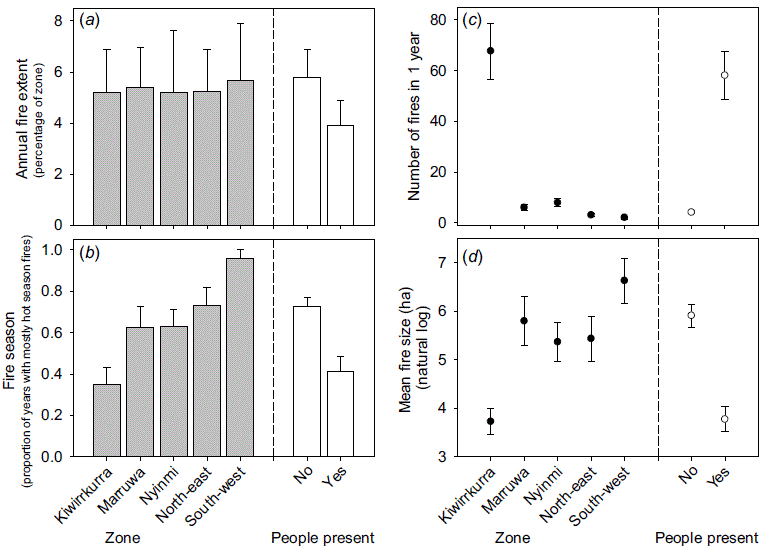
The best-ranked candidate model for the number of fires included rainfall and zone and people. The Kiwirrkurra zone had more fires than any other zones, there were more fires when people were present and the number of fires increased with preceding rainfall but was unaffected by the previous year’s fire extent (Tables 2 and 3).
Fire sizes were larger when rainfall in the preceding 2 years was greater but this was mediated when people were present. There were differences among zones, with Kiwirrkurra having smaller fires than other zones, and the south-western zone having the largest fires (Tables 2, 3, Fig. 3d).
The largest fires across all zones occurred in 2000–02 following exceptional rainfall. In the Kiwirrkurra zone, a fire of 34,000 ha occurred in 2002, at Nyinmi a fire of 63,000 ha occurred in 2002, at Marruwa a fire of 40,900 ha occurred in 2002. The maximum fires sizes in the two unmanaged zones were larger; a fire of 107,400 ha occurred in the north-eastern zone in 2002 and a fire of 103,000 ha occurred in the south-western zone in 2000.
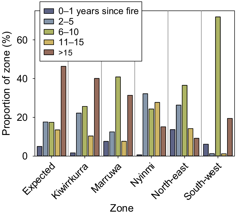
At the end of the 40-year time series, Kiwirrkurra’s distribution of areal extents of five seral (time-since-fire) classes was the closest to the expected distribution (assuming a 20-year fire interval; Fig. 4). The summed differences from expected were 13% for Kiwirrkurra, 26% for Marruwa, 36% for Nyinmi, and 37 and 66% for the north-eastern and south-western unoccupied zones respectively. The distribution of time-since-fire classes in the south-western zone differed the most from expected, mainly because of a very large area of 6–10-year-old vegetation that burnt in 2011–12 after heavy rain. The area of this vegetation age class was also higher than expected in the other zones (apart from Kiwirrkurra), because of the same, extensive post-rain fires (Fig. 4).
The distribution and dispersion of time-since-fire classes in the five zones. The areas (percentage of zone) of time-since-fire classes (0–1 years; 2–5 years; 6–10 years; 11–15 years; and >15 years) in each of the five zones. The first group of bars shows the expected areas assuming a 20-year fire interval.
Oral accounts of fire practices and regimes
The contrast in fire patterns from numerous small fires primarily lit by people to a regime of much larger wildfires ignited by lightning was evident to Kiwirrkurra co-authors when shown the fire scar maps for each decade:
Little fires! Palya [Good], that’s us mob making fires. Walking around with a firestick. Little fires, long time. [Yukultji Ward]
The Pintupi Nine family covered a large area including all the Marruwa zone as well as a considerable distance further north. Pintupi sisters Yukultij and Yalti describe travelling through their country, from soakage to soakage, each carrying firesticks all the way:
Carrying it for a long time, little firestick, not big one. One each, burning spinifex. When you’ve finished and the fire still burning the trees you can walk around. You can leave the firestick on the ground, when it gets all nyaru [burnt clean]. We light the fire then go hunting for kuka [meat]. When it’s all clean rumiya tjuta [lots of goanna]. And lungkata [bluetongue lizard]. [Yukultji Ward]
Yalti said they did not like carrying firesticks in hot weather, suggesting that opportunistic burning conducted during transit or hunting expeditions would have been more likely in the cool weather. This is not to say that fire was not used in the hot season, only that a new fire would need to be ignited for intentional use during hunting and cooking.
Only cold time carrying firestick. Can’t carry in the hot time, just make a new fire when you sit down at camp to cook a feed under a tree using langkaru [spear thrower] and kali [boomerang]. [Yalti Napangati]
Yukultji and Yalti described the succession of plant foods that would become available after an area was burnt:
We walk around to another spot look for tjurnu [soakage] to drink some water and then hey – bushtucker coming in the lurnta [recently burnt areas]. Growing in the nyaru [fresh firescar]. Itakati seed [Yakirra australiensis], lukararra [Fimbristylis oxystachya], wangunu [Eragrostis eriopoda], wayali [Portulaca oleracea]. Then kampurarrpa [desert raisin, Solanum centrale] and pintalypa [bush tomato, S. chippendalei].
Some of the early successional plants also have small grubs (Cossidae larvae) in their roots, which are extracted by ninu:
kanpirr kanpirr [Senna notabilis] and punyani [Indigofera georgei] ninu maku [witchetty grubs], mangari [food] for ninu. After fire ninu coming back for mangari. [Yukultji Ward]
Important game animals would be attracted to the regenerating habitats:
kipara [Australian bustard, Ardeotis australis], emu [Dromaius novaeholladiae] and marlu [red kangaroo, Osphranter rufus] eating pintalypa. [Yukultji Ward]
In contrast to the nomadic family group living at Marruwa until 1984, the Nyinmi families were based at an outstation in the 1990s. They also spent a lot of time engaged in traditional hunting for rabbits, goannas and feral cats, but their activity was confined to a smaller area. They had access to a tractor to travel along the single road between Nyinmi Outstation and Jupiter Well (a distance of 20 km), but most of their foot-based hunting and burning was conducted within several kilometres of the road, so they could return to the outstation each night to sleep.
We were hunting around there [Nyinmi] in the nineties. We’d go hunting all along the roads from Nyinmi to Puntutjarrapa [Jupiter Well]. Travelling on the tractor. [Raymond Olodoodi]
We used to do a lot of rabbit hunting… Puntutjarrapa, Nyinmi, Ngurti, everywhere. My father used to cook a lot of rabbits for supper, breakfast, lunch and tea… We’d burn the scrub and hunt for the rabbits. We were also hunting for Pussycat, goanna, kuniya (woma python), and maybe perentie sometimes. My father would go out hunting all day, leaving in the morning and coming back sunset time, all day hunting and come back with lots of bush tucker. Like three pussycats and goannas. [Johnny Nangagee]
For rumiya and pussycat. So they can see the rumiya hole or pussycat, that’s why they burn him first, waru, bushfire, yuwa [yes]. They take sticks, wood, little one, they burn him right up, take it, leave it there, put another one… Yeah when there’s a lot of spinifex we used to burn fire and if there’s a lot of spinifex burnt, the cats run away to an open place where there’s a good track. And that’s how we catch the cat. [Mantua James]
Although the ignition tools have now progressed from langkurru and kali to matches, the methods Kiwirrkurra people use to burn during hunting activities remain very similar to pujiman days. They still use a tjangi (firestick) or a handful of tjanpi (spinifex grass) to carry the fire between spinifex hummocks, walking in lines perpendicular to the wind to create a larger burnt strip or around in a small circle if they wish to contain the fire to a tight patch.
Since the Kiwirrkurra Ranger program commenced in 2014, Rangers also use other tools to achieve their land management priorities. Rangers use drip-torches to burn fire-breaks for asset protection and conduct aerial incendiary burning in more remote areas.
Persistence of threatened species
The Kiwirrkurra co-authors report hunting for tjalapa at Marruwa in the 1980s. People left Marruwa in 1984. The tjalapa were still present at the Marruwa site in 2000, but were absent by 2012, and have remained absent since. Between the survey visits in 2000 and 2012, the tjalapa site was affected by two large fires of 288,000 ha (in 2002) and 23,000 ha (in 2012). Searches throughout the Marruwa zone have not shown any other tjalapa colonies, although some burrows have been found just outside the zone, 47 km from the original site. The tjalapa were present in the Kiwirrkurra zone in 2000, and have maintained a continuous presence in this area since surveys recommenced in 2014. The fires at this site were more numerous but much smaller than those at Marruwa. After the 2000 survey, a fire of 3 ha affected the site in 2002, and a fire of 480 ha affected the site in 2003, then the site was partly burned in a fire of 40 ha in 2015. Throughout 2000–20, there were several fires in the area around (but not covering) the tjalapa site, with the largest fire of 4300 ha occurring in 2002.
In 2000, we found ninu at nine sites, three in each of the Kiwirrkurra, Marruwa, and Nyinmi zones. By the time the next surveys were conducted in 2012, ninu had disappeared from all three sites in the Nyinmi zone (Fig. 5). Although transient ninu sign occurred west of Nyinmi fleetingly in 2018, no further sign was found on subsequent visits. Ninu were still present at four of the original six sites in the Kiwirrkurra and Marruwa zones during ground surveys in 2020 (Fig. 5). During the aerial surveys in the Kiwirrkurra, Nyinmi, and Marruwa zones in 2020, and the north-eastern zone in 2021, ninu sign was recorded in three separate areas (>10 km apart) in the Kiwirrkurra zone, and four locations (7–10 km apart) in the Marruwa zone, but no sign could be found within the Nyinmi or north-eastern zones.
Schematic showing the presence of ninu at each of nine sites over successive 5-year periods from 2000 to 2020. Ninu persistence is shown by the grey bars, which end (with a black ninu symbol) when ninu became absent at a site, or continue to the right side of the survey period, with a grey ninu, if the species was still present in 2019–21. The accumulated fire extent during each 5-year period is shown for each site by using graded symbols: fire extent was zero or less than 300 ha (an area easily traversed by ninu in 1 week) (no symbol); between 300 and 3000 ha (small symbol); 3000 to 30,000 ha (medium symbol); and over 30,000 ha (large symbol). People presence at the sites is shown with the black bar and the upside-down U-shape (signifies people in Pintupi iconography). Information on the number of low-rainfall years in the Kiwirrkurra IPA during each 5-year period is shown for each interval at the top of the schematic.
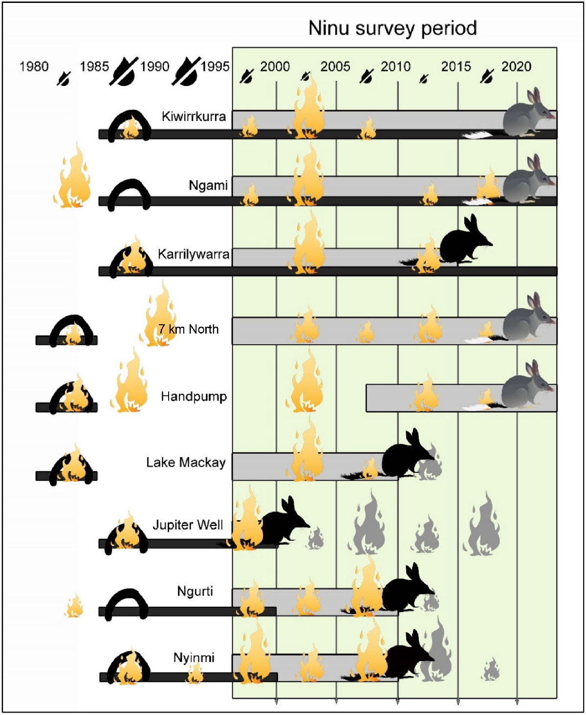
The best-supported model for the presence of ninu at the end of 5-year survey periods included the terms people (ninu presence was more likely when people were present in the previous 5 years) and fire extent (ninu presence was less likely as fire extent in the preceding 5 years increased) (Table 4).
| Term (n = 44) | AICc | ΔAICc | χ 2 | P | Estimate | s.e. | |
|---|---|---|---|---|---|---|---|
| Low-rainfall years | 61.8 | 13.4 | 0.14 | 0.71 | 0.22 | 0.58 | |
| Fire extent (logged) | 59.9 | 11.5 | 4.0 | 0.05 | −0.18 | 0.1 | |
| People | 49.9 | 1.5 | 12.1 | <0.001 | 2.53 | 0.85 | |
| People + fire extent | 48.4 | 0 | People: 11.9 | <0.001 | 2.64 | 0.90 | |
| Fire: 3.79 | 0.05 | −0.21 | 0.11 |
The top-ranked models are shown in bold. χ2 statistics, P-values, estimates and their standard errors, are shown for each variable.
Discussion
This study adds to the growing body of work that demonstrates how Indigenous fire management practices can influence fire regimes in the Australian deserts. Following the pioneering work of Burrows et al. (2006) who showed that the fine-scale seral mosaic evident in the Kiwirrkurra area in 1953 had been homogenised by 1981, here we provide an update that the seral mosaic has been reinstated across a 1550-km2 area surrounding the community of Kiwirrkurra. Through burning activities motivated by the desire to hunt and consume bush foods, Kiwirrkurra people are maintaining a seral mosaic akin to patterns documented during pujiman (pre-contact) time. A similar impact of Indigenous burning practices on the contemporary fire mosaic has been demonstrated from several other Indigenous communities in the Western Deserts (Bliege Bird et al. 2012; Greenwood et al. 2022).
Pintupi co-authors who grew up living traditional lifestyles before 1984 describe burning as an essential tool for food harvesting and production. Information provided by Pintupi women in this study corroborated well with information recorded from male informants in the 1980s (Burrows et al. 2006). Clearing the vegetation makes it easier to find burrows to harvest reptiles, including goannas (Varanus sp.), blue-tongue lizards (Tiliqua sp.) and woma pythons (Aspidites ramsayi) in the fresh firescar. Fire is also used to flush cats from vegetation during a hunt, and to attract Australian bustards to the charred insects immediately after the fire. When sufficient rain follows fire, short-lived seeding and fruiting plants germinate. People know when to return to the regenerating habitat to harvest these seeds and fruits, and to hunt for the bustards, emus and kangaroos that are also attracted to the fresh growth in these areas.
In the pujiman days, most burning was intentional and related to food harvest (or communication), but fires would also have started along travel routes while people kept firesticks alight as they moved between campsites. On the basis of the recollections of our Pintupi co-authors, firesticks were generally not carried as much in the hot weather (presumably because of reasons of personal comfort), meaning casual burning arising from dropped embers during transit was more likely to occur in the cooler months. However fire-making occurred throughout the year for cooking, and specific hunting activities (Burrows et al. 2006).
After people settled in Kiwirrkurra community and at Nyinmi Outstation, they continued to use fire to assist in their harvest of kuka (bush meat) and mirrka (plant foods), despite the availability of food in the Community Store. Although traditional fire lighting tools have been replaced with matches and cigarette lighters, the methods of spreading fire between spinifex clumps, and the reasons for burning remain unchanged. At Nyinmi hunting was limited to a narrow strip along the only access road, but at Kiwirrkurra a network of hunting tracks extends the zone of influence across the 1550-km2 area.
Our analysis of 40 years of satellite imagery documents the strong influence of Pintupi people on the fire regime in the part of the Great Sandy and Gibson Deserts that is now the Kiwirrkurra IPA. When people are on country, using fire during hunting, the number of fires ignited each year is substantially higher, there is a reduction in hot-season fire, and average fire size is significantly smaller than in remote, unmanaged areas devoid of people. While people were present in Kiwirrkurra community, the average fire size was 83 ha, only slightly larger than the average fire size estimated for the Kiwirrkurra region in the 1950s (64 ha, Burrows et al. 2006). The median fire size at Kiwirrkurra was 4.6 ha, compared with 10.2 ha in 1953. By contrast, fires in the two unmanaged zones over the 40-year study period averaged 2680 and 5300 ha.
The largest fires in the 40-year series occurred after heavy rainfall in 1999–2001. All areas of the IPA were affected by large fires after this record rainfall event, including the Kiwirrkurra zone, but this was after the community had been evacuated for 18 months because of flooding. With no-one present to burn as the annual grasses proliferated, large fuel loads accumulated and cured. When people returned to Kiwirrkurra in August 2002, they immediately started burning but extensive fires ensued, affecting 55% of the Kiwirrkurra zone in that year. By contrast, during the high rainfall event of 2010–11, people stayed in the community and continued burning. Notably, this rainfall event was not followed by extensive fires in the Kiwirrkurra zone, yet large wildfires affected all the other four zones at that time (Fig. 2). In fact, there have been no large fires in the Kiwirrkurra zone since the early 2000s, despite heavy rain events that increased fuel loads and resulted in widespread fires elsewhere on the IPA in 2006–07, 2012–13 and 2017–18 (Fig. 2). Perhaps somewhat paradoxically, the area where burning activity has been most frequent and intense throughout the study period has maintained the most area of habitat in mature state; by the end of the study, over 40% of the Kiwirrkurra zone supported long-unburnt vegetation compared with 9 and 19% of the unmanaged zones (Fig. 6).
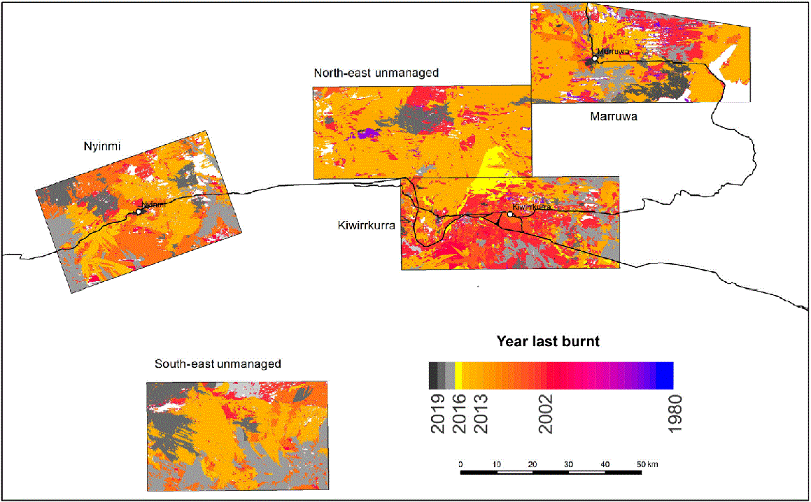
Map showing the dispersion of fire-ages across the five zones at the end of 2019, showing a predominance of medium-aged vegetation across most areas (orange colours: last burnt in 2010–13), but a much higher proportion of old-growth vegetation (red tones: last burnt 2000–05) in the Kiwirrkurra zone.
Desert fire regimes and the persistence of ninu and tjalapa
We argue that the pattern of persistence of ninu and tjalapa on the Kiwirrkurra IPA is related to the presence of people. People can help ninu, tjalapa and other native species by hunting introduced cats and foxes (Paltridge et al. 2020). But another benefit of hunting is that it is often accompanied by burning and perhaps the key influence of people may operate through their effect on the fire regime. Traditional use of fire potentially promotes persistence of ninu and tjalapa in two ways, namely, reducing vulnerability to predators and increasing food resources.
Traditional small-scale burning reduces vulnerability to predators by creating a fine-grain mix of seral stages, and increasing the extent and connectivity of the unburnt vegetation that provides cover and reduces exposure to cats and foxes. Reduced tjalapa burrow occupancy 4 months after fire in another study area was attributed to increased hunting success of predators in the absence of vegetation cover (Moore et al. 2015). Tjalapa were still present in the firescar 1 month after the fire, but the disappearance of most of these skinks in the ensuing months coincided with a very high proportion of tjalapa remains in cat scats (Moore et al. 2018). Surveys in north-western Western Australia demonstrated the importance of long-unburnt spinifex for ninu, where feral cats were much less prevalent than in frequently burnt habitats (Moore et al. 2024). In the northern Tanami Desert, cat activity did not increase after fire, but there was an increase in detection of foxes, and this coincided with a decline in ninu activity after the fire (Geyle et al. 2024a). The amplification of predation following extensive or severe fire has been experimentally demonstrated in diverse habitats such as tropical savannas and temperate forests (McGregor et al. 2014; Leahy et al. 2016; Hradsky et al. 2017; Doherty et al. 2022).
The other advantage of continuously creating a network of small firescars scattered across the landscape is that it provides ongoing opportunities for germination of a diverse range of post-fire ephemerals (Burrows et al. 2020). Many of the early successional species provide edible seeds, fruits or root-dwelling larvae, greatly increasing the productivity of spinifex sandplain habitat, which otherwise has few plant food resources (Burrows et al. 2020). If sufficient rainfall occurs within a few months of hot-season fire, one of the first species to colonise freshly burnt patches is the prolifically seeding grass itakati (Southgate and Carthew 2007). This is one of the most important dietary items for ninu in desert country (Southgate and Carthew 2006). Efficient to harvest because ants clean and gather the seed into piles around their holes (‘like mining’, Yukultji Ward), itakati was also a staple food for Pintupi people who ground the seeds to cook seedcakes (Ward et al. 2023). Thus, as the nomadic Pintupi people walked through country, burning patches of spinifex to produce little gardens of itakati seed and other seeds, fruits and edible grubs in the roots of shrubs, they were also promoting food resources for the ninu, demonstrating a tangible link between the presence of people and ninu. Maintaining country in a heterogenous state with lots of seral stages including recent firescars makes it possible to burn small patches at any time of year, including the hot season, safe in the knowledge of where low fuels will stop the fire. It is important that some hot-season fires occur each year, whether ignited by lightning or people, because these fires are most likely to yield itakati, if sufficient summer rainfall is received. Little itakati is produced on cool-season burns because of the extent of recovery of perennial vegetation cover before summer rainfall is received (Southgate and Carthew 2007).
Between our initial threatened species surveys from 1999 to 2001 and the next survey in 2012, ninu disappeared from Nyinmi and tjalapa disappeared from Marruwa. Despite regular visits to these sites every year since 2014, including track plot searches on the ground, and very low flying helicopter surveys, we have been unable to find any further evidence of either species re-establishing at the previously recorded sites, although there was ninu sign fleetingly in 2018 and a small population of tjalapa has recently been found near the north-western edge of Lake Mackay, 47 km from the original site (and outside the fire mapping zone).
During the same period (between 2001 and 2008) ninu disappeared from the adjacent area of the Northern Territory. The last ninu records from Kintore community were in the 1990s and from Nyirripi community in the early 2000s (R. Paltridge, unpubl. data). These localised extinctions have pushed the southern edge of the range of ninu in the Northern Territory ~100 km further north (Department of Climate Change, Energy, the Environment and Water 2023).
The loss of ninu from both Nyinmi and Nyirripi, and tjalapa from Marruwa, followed the wettest 2 years of the 40-year study period and the most extensive wildfires documented during the study (Fig. 2). The remnant tjalapa colony at Marruwa was affected by two large fires, including one of 288,000 ha in 2002. We postulate that the combination of extensive hot summer wildfires coupled with elevated predator populations after La Niña-driven rodent irruptions led to the local extinctions of ninu at both Nyinmi and Nyirripi and tjalapa at Marruwa soon after 2002. Foxes have been present at Nyirripi, Nyinmi, Kiwirrkurra and Marruwa throughout the 20-year period that tracking surveys were conducted (R. Paltridge and Kiwirrkurra Rangers, unpubl. data) and also feature in hunting stories from Nyinmi in the 1950s where Nanyuma Napangati describes following ninu tracks to a burrow from which she dug up and killed a fox (Nanyuma Napangati, pers. comm., April 2021). In 2000, evidence of fox impacts on ninu was observed at both Nyinmi (where we found the remains of fresh ninu kill with fox tracks and scats), and at the Lake Mackay site on the edge of the Marruwa zone where a fox was raising three cubs in a hole that had recently been occupied by ninu (Y. Ward and R. Paltridge, unpubl. data). High predator densities still prevailed in the freshly burnt landscape in 2004, with tracks of cats and foxes recorded at 88 and 75% of eight track plots surveyed (Kiwirrkurra Rangers, unpubl. data), ultimately leading to localised extinctions. Predator activity was similarly high in 2012 (e.g. foxes were recorded in 72% of 25 track plots; Kiwirrkurra Rangers, unpubl. data); however, no localised extinctions are known to have occurred on the Kiwirrkurra IPA after this La Niña event, possibly because the ninu sites were less affected by fire.
The disappearance of ninu from Nyinmi coincided with the abandonment of the outstation, which led to a reduction in average number of fires per year from 12 to 5, and an increase in average fire size from 770 to 2260 ha. People had an influence only on a small part of this zone during the study period, but this was where the ninu were known to occur. After people left, the three ninu monitoring sites in the Nyinmi zone were repeatedly burnt, mostly in extensive fires (>30,000 ha), in every 5-year period between 2000 and 2020, except for one site–period combination (Ngurti escaped fire in 2015–20; Fig. 5).
By contrast, tjalapa and ninu have persisted in the Kiwirrkurra zone where people have been present, actively hunting and burning, since the 1980s. Within this zone, ninu have persisted at two monitoring sites throughout the 20-year monitoring period, and only recently disappeared from the third (Karrilywarra; Fig. 5). They have also been found at various other sites across the Kiwirrkurra zone in recent years. Although occasional large fires have occurred after exceptional rainfall, these post-rain fires are still much smaller than analogous fires in the unmanaged zones, leaving more long-unburnt vegetation available. Fire size has generally remained at a scale where ninu can move between burrows situated in unburnt habitat where they have greater protection from predators, and adjacent regenerating habitats that support a greater diversity of food.
Ninu have also persisted at Marruwa, where traditional burning was continuous until 1984, and then conducted relatively regularly during the past 20 years as the Pintupi Nine families returned to visit their country or travelled through to the neighbouring community to the north. Since the commencement of the Ranger program in 2014, cool-season burning has been prioritised here in the Ranger’s annual workplan.
Management recommendations
The information presented here demonstrates how traditional burning practices associated with hunting can modify the fire regime in ways that benefit species such as ninu and tjalapa. By burning many small fires each year, a fine-scale network of burnt and unburnt vegetation is created. Although the seral mosaics will occasionally be swamped by extensive wildfires, our analysis of 40 years of fire in the Kiwirrkurra IPA showed that the frequency of rainfall-driven extensive fire was much lower, the size of the largest fires was much smaller, and there was more long-unburnt vegetation, where people hunt regularly.
We recommend supporting the maintenance of traditional foot-based hunting, accompanied by burning, in accessible hunting areas. Where Traditional Owners and rangers are using prescribed burning for conservation purposes, we recommend aiming to create burns that resemble the width of typical hunting fires (~100–200 m wide) and running these fires as long lines adjacent to sites with threatened or culturally significant species. Such fire lines should delay or limit the spread of hot summer fires and protect the sites from being burnt. At the very least, they will diversify food resources and provide an adjacent area for animals to move into that retains some vegetation.
Although the fire-return intervals are generally 10–20 years in dry spinifex deserts such as those around Kiwirrkurra, two successive years of above-average rainfall, yielding at least 800 mm of rain, will produce sufficient cover of ephemeral grasses to carry fire through any seral stage (Fig. 2). To limit the spread of hot summer fires in these situations, pre-emptive cool-season burning, whether from hunting or prescribed, is critical. If the grass has not cured sufficiently to burn in the cool season, further attempts in successive months early in the hot season may be required to find the narrow window of time where fires will carry far enough to produce useful breaks, but not burn vast areas.
Little fire good for ninu, big fire bad one. When ninu piti [burrow] burns tjantu [dingo], waltaki [fox] and pussycat eating ninu. Little fires palya lingku [very good]. When Yukultji and Yalti living in the bush, little fire, little fire, ninu still living. [Yukultji Ward]
Conflicts of interest
Sarah Legge is an Editor-in-Chief of Wildlife Research. To mitigate this potential conflict of interest she had no editor-level access to this manuscript during peer review. The authors have no further conflicts of interest to declare.
Declaration of funding
This project was supported by the 10 Deserts Project/Indigenous Desert Alliance. Funding for the Kiwirrkurra Ranger Program is provided by the National Indigenous Australians Agency through Desert Support Services.
Acknowledgements
We gratefully acknowledge the efforts of Kiwirrkurra Rangers, community members and past and present Traditional Owners of the Kiwirrkurra Indigenous Protected Area for their enduring fire management over many centuries. We acknowledge IPA coordinators Kate Crossing and Dannica Shultz and previous ranger coordinator Shane Doudle. We thank Hannah Cliff from Indigenous Desert Alliance for her oversight of the project and Katrin Doederer for her expert flying skills during both aerial surveys for ninu, and aerial incendiary burning.
References
Abbott I (2008) The spread of the cat (Felis catus) in Australia: re-examination of the current conceptual model with additional information. Conservation Science Western Australia 7, 1-17.
| Google Scholar |
Bird DW, Bird RB, Parker CH (2005) Aboriginal burning regimes and hunting strategies in Australia’s Western Desert. Human Ecology 33, 443-464.
| Crossref | Google Scholar |
Blackwood EMJ, Karajarri Rangers, Bayley S, Biljarni H, Fensham R, Lindsay M, Noakes E, Wemyss J, Legge S (2022) Pirra Jungku: comparison of traditional and contemporary fire practices on Karajarri Country, Western Australia. Ecological Management & Restoration 23, 83-92.
| Crossref | Google Scholar |
Bliege Bird R, Codding BF, Kauhanen PG, Bird DW (2012) Aboriginal hunting buffers climate-driven fire-size variability in Australia’s spinifex grasslands. Proceedings of the National Academy of Sciences 109, 10287-10292.
| Crossref | Google Scholar |
Bolton BL, Latz PK (1978) The western hare-wallaby Lagorchestes hirsutus (Gould) (Macropodidae), in the Tanami Desert. Wildlife Research 5, 285-293.
| Crossref | Google Scholar |
Burbidge AA, McKenzie NL (1989) Patterns in the modern decline of Western Australia’s vertebrate fauna: causes and conservation implications. Biological Conservation 50, 143-198.
| Crossref | Google Scholar |
Burbidge AA, Johnson KA, Fuller PJ, Southgate RI (1988) Aboriginal knowledge of the mammals of the central deserts of Australia. Australian Wildlife Research 15, 9-39.
| Crossref | Google Scholar |
Burrows N, Chapman J (2018) Traditional and contemporary fire patterns in the Great Victoria Desert, Western Australia. Final Report, Great Victoria Desert Biodiversity Trust Project GVD-P-17-002. (Biodiversity and Conservation Science Division, Department of Biodiversity, Conservation and Attractions: Perth, WA, Australia). Available at https://gvdbiodiversitytrust.org.au/wp-content/uploads/2024/03/GVDBT-Final-Report-Traditional-Contemporary-Fire-Patterns.pdf
Burrows ND, Burbidge AA, Fuller PJ, Behn G (2006) Evidence of altered fire regimes in the Western Desert region of Australia. Conservation Science Western Australia 5, 14-26.
| Google Scholar |
Burrows N, Rampant P, Loewenthal G, Wills A (2020) Fire, plant species richness and plants of significance to Australian desert Aboriginal people. International Journal of Wildland Fire 29, 939-942.
| Crossref | Google Scholar |
Department of Climate Change, Energy, the Environment and Water (2023) Recovery plan for the greater bilby (Macrotis lagotis). (DCCEEW: Canberra, ACT, Australia) Available at https://www.dcceew.gov.au/sites/default/files/documents/recovery-plan-greater-bilby-2023.pdf
Doherty TS, Geary WL, Jolly CJ, Macdonald KJ, Miritis V, Watchorn DJ, Cherry MJ, Conner LM, González TM, Legge SM, Ritchie EG, Stawski C, Dickman CR (2022) Fire as a driver and mediator of predator–prey interactions. Biological Reviews 97, 1539-1558.
| Crossref | Google Scholar | PubMed |
Doherty TS, Fandiño DFB, Watchorn DJ, Legge SM, Dickman CR (2024) Experimentally testing animal responses to prescribed fire size and severity. Conservation Biology 38, e14231.
| Crossref | Google Scholar | PubMed |
Edwards GP, Allan GE, Brock C, Duguid A, Gabrys K, Vaarzon-Morel P (2008) Fire and its management in central Australia. The Rangeland Journal 30, 109-121.
| Crossref | Google Scholar |
Fairfax RJ (2019) Dispersal of the introduced red fox (Vulpes vulpes) across Australia. Biological Invasions 21, 1259-1268.
| Crossref | Google Scholar |
Finlayson HH (1961) On central Australian mammals. Part IV – The distribution and status of central Australian species. Records of the South Australian Museum 14, 141-191.
| Google Scholar |
Geyle HM, Schlesinger C, Banks S, Dixon K, Murphy BP, Paltridge R, Doolan L, Herbert M, North Tanami Rangers, Dickman CR (2024a) Unravelling predator–prey interactions in response to planned fire: a case study from the Tanami Desert. Wildlife Research 51, WR24059.
| Crossref | Google Scholar |
Geyle HM, Young AR, Murphy BP, Dickman CR, Schlesinger C, Dixon KM, Moore H, Legge S, Silcock J, Indigo N, Dziminski M, Greatwich B, Newsome TM, Paltridge R, Southgate R, Arkinstall C, Bradley K, Central Land Council Rangers, Jackett N, Kanyirninpa Jukurrpa Rangers, Karrajarri Rangers, Kiwirrkurra Rangers, Kimberley Land Council Land and Sea Management Unit, Moore D, Ngurrara Rangers, Parna Ngururrpa Aboriginal Corporation, Nyangumarta Rangers, Nyikina Mangala Rangers, Skroblin A, Southwell DM, Tait L, Webeck K, Wiluna Martu Rangers, Yawuru Country Managers, Banks S (2024b) Declines in greater bilby (Macrotis lagotis) geographic range and realised niche are best explained by the invasive red fox (Vulpes vulpes). Biological Conservation 302, 110872.
| Crossref | Google Scholar |
Gould RA (1971) Uses and effects of fire among the Western Desert Aborigines of Australia. The Australian Journal of Anthropology 8, 14-24.
| Crossref | Google Scholar |
Greenwood L, Bliege Bird R, Nimmo D (2022) Indigenous burning shapes the structure of visible and invisible fire mosaics. Landscape Ecology 37, 811-827.
| Crossref | Google Scholar |
Hradsky BA (2020) Conserving Australia’s threatened native mammals in predator-invaded, fire-prone landscapes. Wildlife Research 47, 1-15.
| Crossref | Google Scholar |
Hradsky BA, Mildwaters C, Ritchie EG, Christie F, Di Stefano J (2017) Responses of invasive predators and native prey to a prescribed forest fire. Journal of Mammalogy 98, 835-847.
| Crossref | Google Scholar |
Indigenous Desert Alliance (2023) Looking after Tjakura, Tjalapa, Mulyamiji, Warrarna, Nampu. A National Recovery Plan for the Great Desert Skink (Liopholis kintorei). (Department of Climate Change, Energy, the Environment and Water: Canberra, ACT, Australia) Available at www.dcceew.gov.au/environment/biodiversity/threatened/recovery-plans
Kimber R (1983) Black lightning: Aborigines and fire in central Australia and the Western Desert. Archaeology in Oceania 18, 38-45.
| Crossref | Google Scholar |
Kimber RG, Friedel MH (2015) Challenging the concept of Aboriginal mosaic fire practices in the Lake Eyre Basin. The Rangeland Journal 37, 623-630.
| Crossref | Google Scholar |
Kuleshov Y, Mackerras D, Darveniza M (2006) Spatial distribution and frequency of lightning activity and lightning flash density maps for Australia. Journal of Geophysical Research: Atmospheres 111, D19105.
| Crossref | Google Scholar |
Leahy L, Legge SM, Tuft K, McGregor HW, Barmuta LA, Jones ME, Johnson CN (2016) Amplified predation after fire suppresses rodent populations in Australia’s tropical savannas. Wildlife Research 42, 705-716.
| Crossref | Google Scholar |
Long J (1989) Leaving the desert: actors and sufferers in the Aboriginal exodus from the Western Desert. Aboriginal History 13, 9-43.
| Google Scholar |
Lundie-Jenkins G (1993) Ecology of the rufous hare-wallaby, Lagorchestes hirsutus Gould (Marsupialia: Macropodidae) in the Tanami Desert, Northern Territory. I Patterns of habitat use. Wildlife Research 20, 457-475.
| Crossref | Google Scholar |
McGregor HW, Legge S, Jones ME, Johnson CN (2014) Landscape management of fire and grazing regimes alters the fine-scale habitat utilisation by feral cats. PLoS ONE 9, e109097.
| Crossref | Google Scholar | PubMed |
McKenzie NL, Burbidge AA, Baynes A, Brereton RN, Dickman CR, Gordon G, Gibson LA, Menkhorst PW, Robinson AC, Williams MR, Woinarski JCZ (2007) Analysis of factors implicated in the recent decline of Australia’s mammal fauna. Journal of Biogeography 34, 597-611.
| Crossref | Google Scholar |
Moore D, Kearney MR, Paltridge R, McAlpin S, Stow A (2015) Is fire a threatening process for Liopholis kintorei, a nationally listed threatened skink? Wildlife Research 42, 207-216.
| Crossref | Google Scholar |
Moore D, Kearney MR, Paltridge R, McAlpin S, Stow A (2018) Feeling the pressure at home: predator activity at the burrow entrance of an endangered arid-zone skink. Austral Ecology 43, 102-109.
| Crossref | Google Scholar |
Moore H, Yawuru Country Managers, Bardi Jardi Oorany Ranger, Nyul Nyul Rangers, Nyikina Mangala Rangers, Gibson L, Dziminski MA, Radford IJ, Corey B, Bettink K, Carpenter FM, Mcphail R, Sonneman T, Greatwich B (2024) Where there’s smoke there’s cats: long-unburnt habitat is crucial to mitigating the impacts of cats on the Ngarlgumirdi, greater bilby (Macrotis lagotis). Wildlife Research 51(5), WR23117.
| Crossref | Google Scholar |
Morton SR, Stafford Smith DM, Dickman CR, Dunkerley DL, Friedel MH, McAllister RRJ, Reid JRW, Roshier DA, Smith MA, Walsh FJ, Wardle GM, Watson IW, Westoby M (2011) A fresh framework for the ecology of arid Australia. Journal of Arid Environments 75, 313-329.
| Crossref | Google Scholar |
Paltridge R, Ward NN, West JT, Crossing K (2020) Is cat hunting by Indigenous tracking experts an effective way to reduce cat impacts on threatened species? Wildlife Research 47, 709-719.
| Crossref | Google Scholar |
Pausas JG, Keeley JE (2009) A burning story: the role of fire in the history of life. BioScience 59, 593-601.
| Crossref | Google Scholar |
Pausas JG, Ribeiro E (2013) The global fire–productivity relationship. Global Ecology and Biogeography 22, 728-736.
| Crossref | Google Scholar |
Ruscalleda-Alvarez J, Cliff H, Catt G, Holmes J, Burrows N, Paltridge R, Russell-Smith J, Schubert A, See P, Legge S (2023) Right-way fire in Australia’s spinifex deserts: an approach for measuring management success when fire activity varies substantially through space and time. Journal of Environmental Management 331, 117234.
| Crossref | Google Scholar | PubMed |
Russell-Smith J, Yates CP, Whitehead PJ, Smith R, Craig R, Allan GE, Thackway R, Frakes I, Cridland S, Meyer MCP, Malcolm Gill A (2007) Bushfires ‘down under’: patterns and implications of contemporary Australian landscape burning. International Journal of Wildland Fire 16, 361-377.
| Crossref | Google Scholar |
Short J, Turner B (1994) A test of the vegetation mosaic hypothesis: a hypothesis to explain the decline and extinction of Australian mammals. Conservation Biology 8, 439-449.
| Crossref | Google Scholar |
Southgate R, Carthew SM (2006) Diet of the bilby (Macrotis lagotis) in relation to substrate, fire and rainfall characteristics in the Tanami Desert. Wildlife Research 33, 507-519.
| Crossref | Google Scholar |
Southgate R, Carthew S (2007) Post-fire ephemerals and spinifex-fuelled fires: a decision model for bilby habitat management in the Tanami Desert, Australia. International Journal of Wildland Fire 16, 741-754.
| Crossref | Google Scholar |
Southgate R, Paltridge R, Masters P, Carthew S (2007) Bilby distribution and fire: a test of alternative models of habitat suitability in the Tanami Desert, Australia. Ecography 30, 759-776.
| Crossref | Google Scholar |
Tulloch AIT, McDonald J, Cosier P, Sbrocchi C, Stein J, Lindenmayer D, Possingham HP (2018) Using ideal distributions of the time since habitat was disturbed to build metrics for evaluating landscape condition. Ecological Applications 28, 709-720.
| Crossref | Google Scholar | PubMed |
Turner D, Lewis M, Ostendorf B (2011) Spatial indicators of fire risk in the arid and semi-arid zone of Australia. Ecological Indicators 11, 149-167.
| Crossref | Google Scholar |
van Etten EJB (2009) Inter-annual rainfall variability of arid Australia: greater than elsewhere? Australian Geographer 40, 109-120.
| Crossref | Google Scholar |
Verhoeven EM, Murray BR, Dickman CR, Wardle GM, Greenville AC (2020) Fire and rain are one: extreme rainfall events predict wildfire extent in an arid grassland. International Journal of Wildland Fire 29, 702-711.
| Crossref | Google Scholar |
Woinarski JCZ, Burbidge AA, Harrison PL (2015) Ongoing unraveling of a continental fauna: decline and extinction of Australian mammals since European settlement. Proceedings of the National Academy of Sciences 112, 4531-4540.
| Crossref | Google Scholar |
Woinarski JCZ, Braby MF, Burbidge AA, Coates D, Garnett ST, Fensham RJ, Legge SM, McKenzie NL, Silcock JL, Murphy BP (2019) Reading the black book: the number, timing, distribution and causes of listed extinctions in Australia. Biological Conservation 239, 108261.
| Crossref | Google Scholar |
Wright BR, Laffineur B, Roye D, Armstrong G, Fensham RJ (2021) Rainfall-linked megafires as innate fire regime elements in arid Australian spinifex (Triodia spp.) grasslands. Frontiers in Ecology and Evolution 9, 296.
| Crossref | Google Scholar |