

Waterbird and migratory shorebird monitoring in the Gippsland Lakes
Birgita D. Hansen A * , Chris Healey B C , Deb Sullivan B D and Dan R. Weller E
A
B
C
D
E
Abstract
The Gippsland Lakes is 1 of 12 wetland systems in Victoria listed under the Ramsar Convention on Wetlands, with waterbird abundance and species diversity being major contributing factors toward the nomination (Criteria 5 and 6). Waterbird monitoring in the Gippsland Lakes region has been running since the 1980s. The key programs are BirdLife Australia’s Beach-nesting Birds program and Australian Shorebird Monitoring Program, the Gippsland Lakes Important Bird Area monitoring program and the Latham’s Snipe Project. Overall, these programs have revealed variable patterns in abundances across species, with some appearing to decline and others likely to be moving out of the Gippsland Lakes system in wet years. Apparent population decreases may reflect changes in foraging habitat suitability but gaps in survey coverage mean that some birds are almost certainly being missed during monitoring. Investment to support a comprehensive assessment of all data sources to determine the specific nature of apparent species’ trends is urgently required.
Keywords: citizen science, East Asian-Australasian Flyway, ecological character, fairy tern, Gippsland Lakes Key Biodiversity Area, hooded plover, little tern, monitoring, waders.
Introduction
The Gippsland Lakes Ramsar site is 1 of 20 Australian sites listed in 1982 under the Ramsar Convention on Wetlands. It was nominated because of four criteria, of which Criteria 5 and 6 are specific to wetland-dependent birds or waterbirds (BMT WBM 2011; Hansen et al. 2021). At the time of nomination, the Gippsland Lakes regularly supported 40,000–50,000 waterbirds (Criterion 5) and at least six waterbird species occurring in internationally significant numbers (i.e. representing 1% or more of their population; Criterion 6) (Casanelia 1999).
The Gippsland Lakes have supported substantial congregations of migratory shorebirds in the past, and it was traditionally one of the most well-known waterbird and migratory shorebird sites in Victoria (Corrick and Norman 1980; Lane 1987; Watkins 1993; BMT WBM 2011). This diversity of waterbirds reflects the geomorphological, hydrological and ecological complexity of the lakes system. However, even prior to listing there were clear signs of deterioration in the ecological character of the Ramsar site (Newall and Fisk 2023). Reliance of waterbirds on diverse wetland habitats and their influence on aquatic food webs mean that changes in waterbird populations may be associated with significant changes in other ecosystem functions (Green and Elmberg 2014; Loyn et al. 2023). Therefore, detailed knowledge of waterbird population trends is important for understanding key threats and drivers, and devising appropriate management responses.
There are four main monitoring programs conducted in the Gippsland Lakes region that target waterbirds: the Australian Shorebird Monitoring Program (formerly Shorebirds 2020), the Hooded Plover Biennial Count via the Beach-nesting Birds program, the Gippsland Lakes Important Bird Area (GLIBA) Project and the Latham’s Snipe Project. These medium- to longer-term programs are conducted alongside shorter, targeted projects like the Managing Threatened Terns in the Gippsland Lakes project (Andrews n.d.). A fifth program, the Summer Waterfowl Count, is coordinated by the Victorian State Government and collects aerial and ground-based survey data on game bird species to inform harvest models for annual hunting season regulation (Menkhorst et al. 2023).
Despite a vast amount of activity and data collection over the decades, insights from these monitoring programs are surprisingly limited. The aim of this short paper is to compile information from these monitoring programs in order to provide an indication of patterns in key species abundance that warrant further investigation and potentially a management response.
Methods
The Australian Shorebird Monitoring Program, the Hooded Plover Biennial Count via the Beach-nesting Birds program, the GLIBA project and the Latham’s Snipe Project were the focus for this compilation due to their duration, coverage and/or relevance for informing Ramsar planning and management. The Summer Waterfowl Count was excluded as the data summaries are restricted in detail and no information is provided on abundance or trends in waterbirds in relation to the Ramsar site (although it is noted that the Summer Waterfowl Count has expanded in scope in recent years to collect this information: Menkhorst et al. 2023).
Information on the four monitoring programs was assembled via the collective knowledge of the authors, each of whom has been involved in these programs and has detailed local knowledge about waterbird populations in the Ramsar site. Where possible, online or peer-reviewed published material was used to compile information on these programs. However, some programs have very little supporting published information, requiring this compilation to rely on other (unpublished) resources each author had access to.
The compilation was used to provide a brief history of each program and document the details of survey methods. Where available, raw abundance data were used to determine daily, seasonal or annual maximum abundance of 13 species listed in relation to criterion 6 in the 2011 ECD (BMT WBM 2011), as well as Latham’s Snipe, over the last 10 years (or less, depending on data availability). Abundance data from the GLIBA surveys were constrained to their 12 core survey sites.
Monthly rainfall data from the Bairnsdale Airport gauge (085279) were downloaded from the Bureau of Meteorology (2024) and summed to produce an annual rainfall total over the same time frame as the waterbird surveys. Rainfall data was plotted against total waterbird abundance (all waterbird species recorded) from the GLIBA survey 12 core sites to explore patterns in relation to wet and dry years, as it is well known that Australian waterbirds will move in response to both local and inland weather patterns (Norman and Chambers 2010).
Results
Overview of Gippsland Lakes survey programs
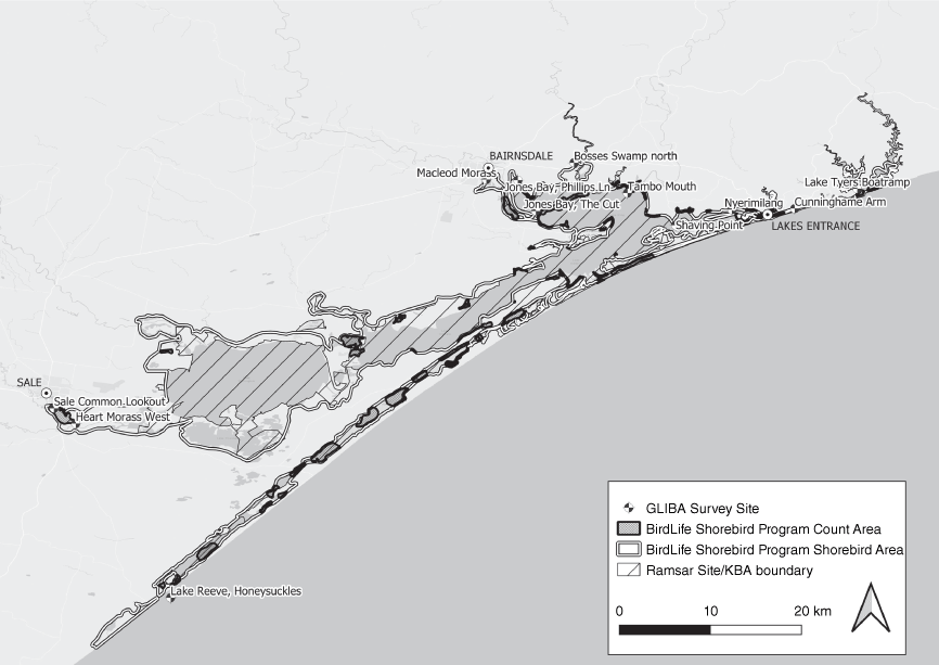
The Gippsland Lakes have been part of the Australian Shorebird Monitoring Program conducted by the Australasian Wader Studies Group, and now BirdLife Australia, since program commencement in the 1980s (Hansen et al. 2019). The Gippsland Lakes shorebird survey area covers around 115,000 ha (Fig. 1), which is surveyed twice a year (mid-summer and mid-winter) by BirdLife Australia volunteers (Table 1). The program aims to collect data on national species distribution and abundance for analyses of longitudinal trends. These inform periodic revision of the East Asian-Australasian Flyway (EAAF) population estimates for migratory shorebird species.
Map of the Gippsland Lakes in eastern Victoria showing the BirdLife Australia shorebird monitoring areas, the Ramsar site and Key Biodiversity Area (KBA) site boundaries, and the locations of the Gippsland Lakes Important Bird Area core monitoring sites.
| Program name | Lead organisation | Start year | Frequency | Coverage | Species targeted | Survey method | Further information | |
|---|---|---|---|---|---|---|---|---|
| Australian Shorebird Monitoring Program | BirdLife Australia (previously Australasian Wader Studies Group) | 1981 | Bi-annual (mid-summer, mid-winter) | Gippsland Lakes Shorebird Area | Migratory and resident shorebirds | Foot-based and boat-based fixed point counts and 500 m area searches | Hansen et al. (2019) | |
| Hooded Plover Biennial Count via the Beach-nesting Birds program | BirdLife Australia | 1980 | Biennial (single weekend in November) | Lake Tyers to Seaspray coastline including some inner islands within the lakes | Hooded Plover, Red-capped Plover, Sooty and Pied Oystercatchers | Census along fixed survey routes | Ekanayake (2023) | |
| Gippsland Lakes Important Bird Area monitoring program | BirdLife East Gippsland | 2012 | Bi-annual (to 2019); quarterly (since 2019) | Between 13 and 23 major wetlands identified in the Gippsland Lakes Ramsar Site Management Plan | Wetland-dependent bird species | Fixed point counts (20 min) | Healey (2020) | |
| The Latham’s Snipe Project | Federation University | 2016 | Single day count, thrice yearly (mid-Sept, mid-Nov, mid-Jan) | Hollands Landing, Point Fullarton, Heart Morass, Flooding Creek plus 8 adjacent wetlands | Latham’s Snipe | Foot-based ‘flushing transects’ (variable time and distance) | Hansen (2017); Hansen et al. (2022b) | |
| Summer Waterfowl Count | Game Management Authority | 1987 | Annual (over 3 week window during hunting season) | Priority wetlands (Dowds Morass, Clydebank Morass, Heart Morass, Hollands Landing, Macleods Morass) | Primarily (game) ducks with other waterbird species added from 2015 | Fixed point counts | Menkhorst et al. (2023) |
The Hooded Plover Biennial Count is part of BirdLife Australia’s Beach-nesting Birds program (Table 1) that began in the 1980s in Victoria. It aims to track the trajectory of the hooded plover (Thinornis cucullatus) population across its eastern Australian mainland range over time, and to simultaneously assess the importance of ocean beach habitats for hood plovers and other non-migratory coastal shorebird species.
The GLIBA Project has been conducted by BirdLife East Gippsland (BLEG) since November 2011, monitoring wetland bird communities across ~60,000 ha of the Gippsland Lakes from Lake Tyers in the east to Lake Reeve and Sale in the west. There are 23 sites that have been surveyed 2–4 times a year for a minimum of 5 years, with 12 of these representing core sites that have been surveyed for 10 years (Fig. 1, Table 1). The project was initiated to collect information on the composition of wetland bird communities and abundance of constituent species. The basis for this monitoring was to determine waterbird responses to anticipated changes to the ecological character of the lakes caused by (1) increasing salinity from projected sea level rise, diminishing freshwater inflows and reduced rainfall; and (2) increases in sediment, nutrient and contaminant loads caused by more frequent wildfire and consequent changes in catchment vegetation cover (Kirono et al. 2022).
The Latham’s Snipe Project commenced in 2014 and includes a national-scale monitoring program for the migratory Latham’s snipe (Gallinago hardwickii). The program has 150 sites across Victoria, 12 of which are located within and adjacent to the Gippsland Lakes IBA–Ramsar site boundary (Table 1). The aim of this program is to collect data that will improve knowledge about the distribution and abundance of this species and enable trends analysis (Hansen 2017).
Patterns in waterbird abundance
The Australian Shorebird Monitoring Program is the most comprehensive (in terms of spatial coverage) and longitudinally consistent dataset. It has been subject to several major analyses with two of the more recent ones focused on estimating East Asian-Australasian Flyway population estimates (Hansen et al. 2022a; BirdLife Australia unpubl. data). These use maximum annual (modelled) abundance over a 10-year analytical window to determine flyway population sizes. Red-necked stint (Calidris ruficollis) was the only species reported in substantial numbers in the 2016 revision (although not exceeding the 1% population threshold), while estimates of the number of other shorebird species were relatively low (Table 2). Abundance of individual shorebird species since has been relatively low compared with historical numbers and no species meets the criterion 6 threshold (Table 2).
| Species | 1% threshold A | 2016 FPE revision | Birdata 2014–2023 B | GLIBA surveys C | |
|---|---|---|---|---|---|
| Australasian grebe | 10,000 | NA | NA | 11 | |
| Black swan | 10,000 | NA | NA | 4060 | |
| Chestnut teal | 1000 | NA | NA | 2074 (6/2023) | |
| Curlew sandpiper | 900 | 0 | 30 | 0 | |
| Eurasian coot | 10,000 | NA | NA | 13,006 (6/2018) | |
| Fairy tern | 15 | NA | NA | 14 | |
| Great cormorant | 1000 | NA | NA | 4005 (12/2014) | |
| Grey teal | 20,000 | NA | NA | 1052 | |
| Latham’s snipe | 360 | 0 | 50 | 11 | |
| Little tern | 1000 | NA | NA | 17 | |
| Musk duck | 250 | NA | NA | 27 | |
| Red knot | 1100 | 1 | 3 | 0 | |
| Red-necked stint | 4750 | 3959 | 300 | 29 | |
| Sharp-tailed sandpiper | 850 | 0 | 300 | 127 |
The Hooded Plover Biennial Count findings have been reported up to 2022 (Ekanayake 2023), where surveys in the Gippsland Lakes form part of a larger area between Lake Tyers and Seaspray (Ekanayake 2023). This region had a marginal increase in the number of hooded plovers between 2020 and 2022; however, this was likely related to an increase in survey area coverage (Ekanayake 2023). Densities of hooded plovers have varied substantially over the previous decade with 2022 densities very similar to 2012 densities (around 0.2 birds/ha), but with much larger densities in 2018 and 2020. This largely stems from this region having the most variability in coverage over time due to the challenges of access (requiring boat and vehicle surveys) and the lack of investment in coordination. This makes it difficult to determine actual trends in population size and distribution.
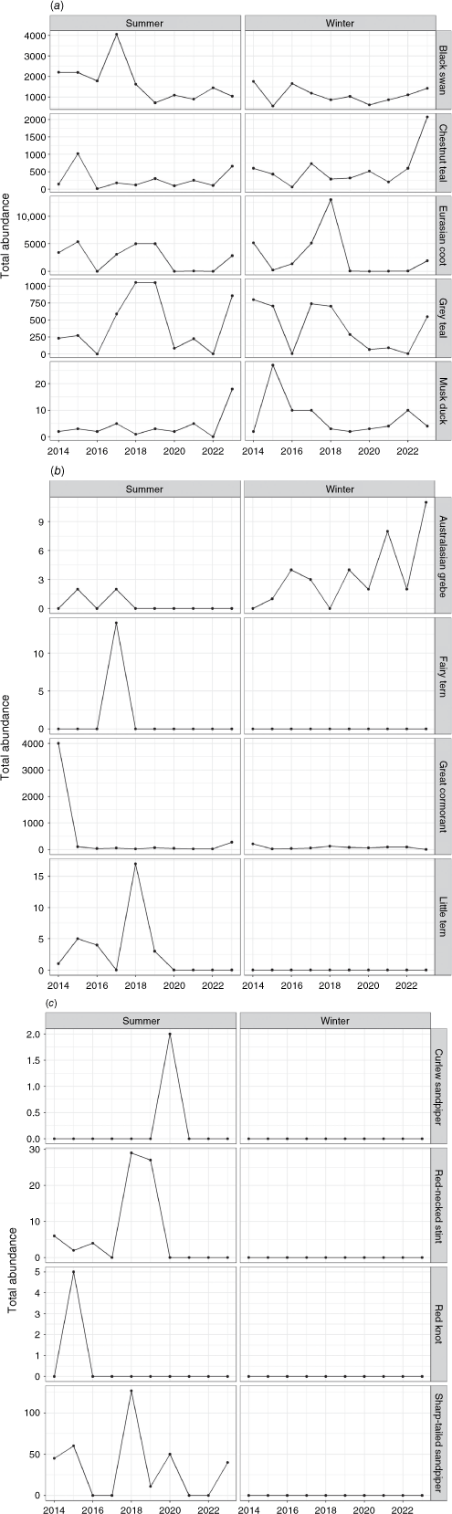
The GLIBA monitoring data revealed highly variable seasonal population patterns in the 14 species documented here (Fig. 2). There were decreases in black swan (Cygnus atratus) (summer) and grey teal (Anas gracilis) (winter), and increases in Australasian grebe (Tachybaptus novaehollandiae) and chestnut teal (Anas castanea) (winter) (Fig. 2a). Red knot (Calidis canutus) and curlew sandpiper (Calidris ferruginea), once significant species for the Ramsar site, were virtually absent from the Gippsland Lakes IBA over the entire period (Fig. 2c).
Seasonal patterns in waterbird abundance of 13 key species listed in relation to criterion 6 (Table 2) across 12 core Gippsland Lakes Important Bird Area project monitoring sites. (a) Contains swans, coots and ducks. (b) Contains grebes, terns and cormorants. (c) Contains shorebirds. There was insufficient information on Latham’s snipe to include.
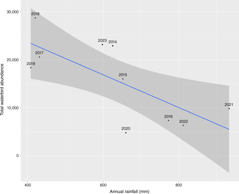
There was a strong negative correlation between total waterbird abundance across the 12 core sites and total annual rainfall at the Bairnsdale Airport gauge (Fig. 3), which supports the notion that many birds move out of the Gippsland Lakes system in wet years.
Total waterbird abundance of all species summed over the 12 core survey sites from summer and winter surveys, plotted against total annual rainfall recorded at the Bairnsdale Airport gauge. The smoother is a linear model with standard errors. Individual years are labelled.
Latham’s snipe has been recorded in numbers typically ranging from 100 to 200 birds across ~8 sites since the Latham’s Snipe Project commenced in the region in 2018 (BirdLife Australia unpubl. data). Three individual sites (Heart Morass, Flooding Creek–Lake Guyatt and Point Fullarton) have exceeded the criteria for national importance under the Environment Protection and Biodiversity Conservation Act (18 snipe: Commonwealth of Australia 2017) on several occasions (BirdLife Australia unpubl. data). However, there have been no records of Latham’s snipe meeting criterion 6 (Table 2).
Discussion
The 2011 Ecological Character Description (ECD) listed red-necked stint and sharp-tailed sandpiper (Calidris acuminata) based on maximum counts (8000 and 3187, respectively) exceeding 2% of the EAAF population (BMT WBM 2011). Since that time, shorebird numbers have dropped markedly with no species listed in relation to Criterion 6 (BMT WBM 2011) exceeding 300 individuals. Over all survey programs, the only waterbird species that appear to have met Ramsar criterion 6 in the last 10 years are chestnut teal, Eurasian coot (Fulica atra) and great cormorant (Phalacrocorax carbo). This is reflected in the recent addendum to the 2011 ECD, which lists no migratory shorebirds against Criterion 6 (Hale 2023). The apparent loss of migratory shorebirds may be attributable to changes in population size but may also reflect changes in survey coverage, as some sites used by shorebirds are not included in contemporary surveys.
Population size changes may reflect changes in habitat suitability and/or survey effort over time. Locations such as Lake Reeve and Jones Bay support shorebirds depending on hydrological and climatic conditions. For example, Lake Reeve has previously supported significant populations of sharp-tailed sandpiper and red knot, but in drought periods the habitat is unsuitable for shorebirds due to hypersalinity and drying of the mudflats. Jones Bay will often support migratory shorebirds dependent on outflows from the Mitchell River. Areas such as the western morasses and fringing wetland habitat on the southern side of Lake Wellington contain habitat suitable for shorebirds, but the southern lake shores and barrier islands are mostly unsurveyed. Many of these areas are also ephemeral, with habitat conditions being suitable for migratory shorebird species only for limited periods and not on a predictable annual basis.
GLIBA project observers have noted that up until 2020 the main part of Jones Bay frequently supported large feeding concentrations (up to 10,000) of Eurasian coot and black swan. Since winter following the 2019–2020 Eastern Victorian fires, numbers of birds have plummeted to a few dozen grebes and cormorants, and no swans or coots (BirdLife East Gippsland unpubl. data). This change in numbers coincides with the commencement of the La Niña climate cycle, which would have resulted in many species shifting inland (as is typical for Australian waterbirds: Norman and Chambers 2010). Indeed, there was a strong negative correlation between total waterbird abundance and annual rainfall, which supports this notion. There may also have been a concurrent impact on food resources due to sediment inputs to the bay by the heavy rains following the fires (Kirono et al. 2022).
Local actions are important to maintaining and reinstating habitat for waterbirds and may require continual implementation to ensure sufficient resources for waterbirds over different climate periods. For example, an extensive multi-agency sand renourishment program to improve habitat for shorebirds and beach-nesting birds was completed in 2016 (Alluvium 2020). There was an immediate increase in breeding success of fairy terns (Sterna nereis) and little terns (Sterna albifrons), target species in the Ramsar management plan, as well as an increase in foraging habitat for shorebirds (Andrews n.d.). Based on the success of this project, it will be repeated in 2024. This illustrates the need for appropriate management actions based on documented population trends.
Collectively, these waterbird monitoring programs cover substantial areas and include many species. However, despite these efforts, key habitats such as the barrier islands are largely underrepresented in these datasets. This is reflected in anecdotal records of larger groups of some shorebirds contained in citizen science platforms such as eBird (www.ebird.org), which have not been detected in standard surveys. A relatively recently established waterbird monitoring program funded by the Gippsland Lakes Coordinating Committee, and being undertaken by BirdLife Australia, is aiming to increase information on all waterbird species including threatened species such as small terns.
It is clear from this data snapshot that there are patterns in waterbird abundance that warrant further investigation. This should include comprehensive analyses of all datasets for waterbird population size and distribution across the lakes system, as well as an assessment of the representativeness of key habitats for priority waterbird species in each survey program. As these programs largely rely on passive volunteer uptake for data collection, further investigation of population trends and standardised threats assessment will require targeted investment. This will be important to determine whether changes in waterbird and shorebird populations reflect broader changes in ecological character and/or factors operating outside the Gippsland Lakes system.
Data availability
The data reported in this paper are available from BirdLife Australia on direct request https://birdata.birdlife.org.au/wp-content/uploads/2022/12/Birdata-Request-Form.pdf. The Latham’s Snipe Project data for the Gippsland region are accessible through BirdLife Australia. For a full dataset please contact the lead author (b.hansen@federation.edu.au).
Acknowledgements
This article provides an overview of the outcomes from decades of (largely) volunteer monitoring, for which we are very grateful. We would like to thank Grainne Maguire and Judi Walters for helpful comments on a draft version.
References
BirdLife Australia (2024) Birdata [Dataset]. BirdLife Australia. Available at https://birdata.birdlife.org.au/request-data
Bureau of Meteorology (2024) CDO (Climate Data Online) – Temperature, Rainfall, and Solar Exposure - Daily and Monthly Values per site (1832 onwards) [Dataset]. Available at http://www.bom.gov.au/metadata/catalogue/19115/ANZCW0503900338 [accessed 22 March 2024]
Casanelia S (1999) Gippsland Lakes, Victoria - 21. Information Sheet on Ramsar Wetlands (RIS). Available at https://www.ramsar.org/ramsar-fact-sheets [accessed 22 February 2019]
Commonwealth of Australia (2017) ‘EPBC Act Policy Statement 3.21—Industry guidelines for avoiding, assessing and mitigating impacts on EPBC Act listed migratory shorebird species.’ (Australian Government) Available at https://www.dcceew.gov.au/environment/epbc/publications/shorebirds-guidelines
Corrick AH, Norman FI (1980) Wetlands and waterbirds of the Snowy River and Gippsland Lakes catchment. Proceedings of the Royal Society of Victoria 91, 1-15.
| Google Scholar |
Ekanayake K (2023) Report on the 2022 Biennial Hooded Plover Population Count. (Report by BirdLife Australia) Available at https://beachvol.birdlife.org.au/public_files/42/Report%20on%20the%202022%20Biennial%20Hooded%20Plover%20Population%20Count.pdf
Green AJ, Elmberg J (2014) Ecosystem services provided by waterbirds. Biological Reviews 89(1), 105-122.
| Crossref | Google Scholar | PubMed |
Hale J (2023) ‘Addendum to the Ecological Character Description for the Gippsland Lakes Ramsar Site.’ (Department of Energy, Environment and Climate Change: East Melbourne) Available at https://www.water.vic.gov.au/waterways/wetlands/significant-wetlands#heading-6
Hansen B (2017) Site fidelity, migration, movement and habitat preference of Latham’s Snipe: the story so far. Wader Quest Newsletter 4, 12-14.
| Google Scholar |
Hansen BD, Clemens RS, Gallo-Cajiao E, Jackson MV, Kingsford RT, Maguire GS, Maurer G, Milton D, Rogers DI, Weller DR, Weston MA, Woehler EJ, Fuller RA (2019) Shorebird monitoring in Australia: a successful long-term collaboration among citizen scientists, governments and researchers. In ‘Monitoring threatened species and ecological communities’. (Eds S Legge, DB Lindenmayer, NM Robinson, BC Scheele, DM Southwell, BA Wintle) pp. 149–164. (CSIRO Publishing: Melbourne)
Hansen BD, Szabo JK, Fuller RA, Clemens RS, Rogers DI, Milton DA (2021) Insights from long-term shorebird monitoring for tracking change in ecological character of Australasian Ramsar sites. Biological Conservation 260, 109189.
| Crossref | Google Scholar |
Hansen BD, Rogers DI, Watkins D, Weller DR, Clemens RS, Newman M, Woehler EJ, Mundkur T, Fuller RA (2022a) Generating population estimates for migratory shorebird species in the world’s largest flyway. Ibis 164, 735-749.
| Crossref | Google Scholar |
Hansen B, Ura T, Tajiri H (2022b) Insights into migration and distribution of Latham’s Snipe. Tattler 51, 22-24.
| Google Scholar |
Kirono D, Hopkins M, Melbourne-Thomas J, Biswas T, Dunlop M, Round V, Sheppard M, Joehnk K, Briggs P (2022) Vulnerability of the Gippsland Lakes Ramsar Site and its catchment to bushfire and climate change. Final Report submitted to the Department of Agriculture, Water and the Environment, DAWE. (CSIRO: Australia) Available at https://www.dcceew.gov.au/water/wetlands/publications
Loyn RH, Rogers DI, Swindley RJ, Menkhorst PW, Stamation K, Haynes S, Graham H, Hepworth G, Steele WK (2023) Waterfowl populations decline with nutrient reduction and increase with nutrient restoration: 20 years of adaptive management at a Ramsar-listed wastewater treatment plant. Hydrobiologia 850(19), 4127-4147.
| Crossref | Google Scholar |
Menkhorst P, Brown G, Stamation K (2023) Victorian Duck Season Priority Waterbird Count, 2023. Unpublished Client report for the Wildlife Policy Section, Department of Energy, Environment and Climate Action and the Game Management Authority. (Arthur Rylah Institute for Environmental Research, Department of Energy, Environment and Climate Action: Heidelberg, Vic.) Available at https://www.parliament.vic.gov.au/490e8a/contentassets/c71be3ecfc8841969d3725db72a92a02/reply-qon_3-attachment-from-deeca-hearing_03072023.pdf
Norman FI, Chambers LE (2010) Counts of selected duck species at Corner Inlet, Victoria: changes in relation to local and distant meteorological variations. International Journal of Biometeorology 54, 269-282.
| Crossref | Google Scholar | PubMed |
Wetlands International (2024) Waterbird Populations Portal. Retrieved from wpp.wetlands.org [5 April 2024]