

VegMachine.net. online land cover analysis for the Australian rangelands
Terrence S. Beutel A B C , Rebecca Trevithick B , Peter Scarth B and Dan Tindall BA Department of Agriculture and Fisheries, PO Box 6014, Red Hill, Rockhampton, Qld 4701, Australia.
B Department of Environment and Science, GPO Box 2454, Brisbane, Qld 4001, Australia.
C Corresponding author. Email: terry.beutel@daf.qld.gov.au
The Rangeland Journal 41(4) 355-362 https://doi.org/10.1071/RJ19013
Submitted: 18 March 2019 Accepted: 27 May 2019 Published: 5 August 2019
©The State of Queensland (through the Department of Agriculture and Fisheries) 2019 Open Access CC BY-NC-ND
Abstract
This paper documents the development and use of the VegMachine.net land cover monitoring tool. From 2002 to 2015, VegMachine® software was used by government agencies, natural resource management (NRM) groups and individual pastoralists in northern Australia to assess and benchmark vegetation cover levels. In 2016 the VegMachine.net website was launched to build a wider user base and assure service continuity. Users can now graph historical (1990–) cover on one or more user defined areas of interest (AOI), produce comprehensive paddock-by-paddock property monitoring reports, and view a range of land cover raster images through the website map panel. In its first 32 months of operation 913 users logged 1604 sessions on the website and more than 1000 of the website’s most comprehensive monitoring reports were distributed to users. Levels of use varied; 26% of users (n = 237) have used the website more than once, and within this group a smaller set of regular users (n = 36) have used the site more than five times, in many cases to provide analyses to multiple clients. We outline four case studies that document the significant impact VegMachine.net has had on users including graziers, government agencies, NRM groups and researchers. We also discuss some possible paths forward that could widen the user base and improve retention of first time users.
Additional keywords: environmental change, grazing pressure, land management, rangeland health, rangeland management, remote sensing.
Introduction
Remote sensing assists rangeland monitoring at many scales, and the range and volume of available datasets derived from remote sensing has increased rapidly over recent decades. Correspondingly, as rangeland stakeholders have recognised the value of remotely sensed data to inform management and demonstrate stewardship, demand for these data has also increased (Reeves et al. 2015). In the rangelands, remotely sensed datasets have quantified and mapped topography, productivity, fire and ecological degradation (Reeves and Baggett 2014, Lawley et al. 2016; Ramoelo et al. 2018), but the most frequent focus has been on land cover. This may be because total cover is easier to define and remotely quantify than more complex attributes like erosion and degradation, and also because cover is a component/correlate some more complex attributes, which has encouraged its use as a proxy for them.
Australian agencies have invested heavily in remote assessment of vegetation cover, and particularly ground cover (Caccetta et al. 2007; Guerschman et al. 2009; Scarth et al. 2010; Trevithick et al. 2014; Guerschman et al. 2015; Scarth et al. 2015; Barnetson et al. 2017). Today, there are comprehensive multi-decadal ground cover time series derived from both MODIS and Landsat sensors that cover the entire country (Clancy et al. 2013; Stewart et al. 2014). These data can be used to monitor ground cover levels, and perhaps more interestingly, longer term patterns that correlate with other landscape attributes like land condition (e.g. Wallace et al. 2004; Karfs et al. 2009). Consequently, the ground cover archives are incorporated in a wide range of national, state and regional monitoring and evaluation processes (e.g. Bastin 2008; Leys et al. 2016; Queensland Government 2018; Zhang and Carter 2018).
At the farm scale, there is clear potential for these data to support better management. On-ground, site scale knowledge improves the interpretation of remote sensing (Lawley et al. 2016; Eddy et al. 2017), and most managers have detailed knowledge of their land and management history. This gives them unique capacity to interpret ground cover changes in the context of their paddock layouts, stocking rates and other local variables. In turn, they can better quantify the effects of their management on the grazed landscape, and so inform more sustainable management. Despite this potential though, the size of ground cover archives and the cost and complexity of interrogating them have hampered land manager access. This has left ground cover data out of the reach of most rangeland managers.
VegMachine® software was developed as a simple tool for interrogating large raster time series. It was built to bridge the gap between emerging cover datasets and land managers wanting to use them (Beutel et al. 2004; Karfs et al. 2004). From 2002 to 2015 it pioneered land cover analysis for land managers and natural resource management (NRM) groups in the Australian rangelands (Thornes 2007; Beutel et al. 2015), allowing non-technical users to better understand the effects of management on landscape, and particularly on vegetation cover dynamics. Work began in 2015 to move VegMachine services to an online delivery mode, and in 2016 the VegMachine.net website was launched as a national land cover monitoring tool. The web service is not the only web-based tool providing ground cover analysis in the Australian rangelands (e.g. Zhang and Carter 2018, FarmMap4D 2018); however, it is the only nationwide web service that allows any user to monitor ground cover (1990–) at any location in Australia. Consequently, it significantly advances the way rangeland stakeholders measure landscape change, and their ability to understand the relationships between rangeland change and rangeland management.
In this paper we describe the VegMachine.net web service and how it is used. We then outline its history including that of the preceding VegMachine software. We detail the website’s layout, underlying datasets and major functions. We then focus on user demographics and activity including four case studies that show how the tool is currently used. We conclude with some learnings from the website’s development and a discussion regarding future developments on the website.
Development history
In 2002, the Commonwealth Scientific and Industrial Research Organisation (CSIRO) developed the VegMachine software for Microsoft Windows personal computers (PC). It allowed simple interrogation of large image time series. In particular, it could compare cover history on a user defined area of interest (AOI) with simultaneous cover levels on similar land types in the surrounding region (Karfs et al. 2004). The rationale for this comparison was that if the AOI and region shared both rainfall history and land type, any differences were likely management driven. This gave users insights into the impacts of past management decisions on the landscape. As part of the same multi-agency project, extension staff supported software users on 31 pastoral properties across northern Australia, providing software, training and annually updated property datasets (Peel et al. 2006). From 2005 to 2008 the same support was extended to an additional 16 properties western Queensland, and a final survey of software users showed that 75% agreed that the software was easy to use, and 53% agreed that having VegMachine influenced their land management (Beutel and Silcock 2008). However, two significant challenges were evident by 2008; the cost of face-to-face support for geographically dispersed users, and the difficulty of keeping users proficient on software they used irregularly.
The VegMachine software was updated in 2009 and a training package was developed in 2010 (Beutel et al. 2015). In Queensland, a new approach to delivery was also trialled to overcome the cost and proficiency issues identified above. Extension providers in the grazing industry were assisted to operate the software on behalf of grazier clients, freeing graziers from operating the software, deferring some support costs to operators, and giving operators a useful client engagement tool. Between 2010 and 2015, more than 60 Queensland government, NRM and agricultural consultancy personnel were trained on the upgraded software, and provided with regional datasets. The software was embedded in the corporate activities of several agencies and NRM groups. The Department of Agriculture and Fisheries (DAF) used VegMachine in one-on-one extension activities, mostly in discussions about management practices. VegMachine was also used to evaluate potential investments on more than 300 grazing sites by the Fitzroy Basin Association (FBA) and North Queensland Dry Tropics (NQDT) NRM groups (Beutel et al. 2015). By the end of 2015 though, the software was due for either another update or transfer online to assure its continuity. Online delivery was viewed as a better option to reach more users, and work began in 2015 on the web service.
The VegMachine.net website
The VegMachine.net website launched on 28th of July 2016. The site can be accessed for free via a web browser, with no user registration and no geographic restrictions on user queries. It was designed for a broad user group including land managers, agency staff and researchers, so website design focussed on maintaining a small number of simple layouts and workflows. This was intended to ensure most users could operate the website without significant support.
The main elements of the VegMachine.net homepage are a menu bar, graph panel and map panel. AOIs are defined by polygons in the map panel, which has tools for drawing, deleting, naming, importing and saving these polygons. The map panel can display a base map as well as images from seven cover time series. Users can search for locations within Queensland using land parcel identifiers, and nationally using street address or geographic coordinates. The website has several help facilities including a manual, help popups, and links to a YouTube channel with instructional help videos. The site offers three groups of tools; interactive analyses which are shown in the website graph panel (Table 1), delivered reports that users request on the website and receive by email (Table 1), and visual image displays that allow users to progressively view raster time series in the map panel (Table 2). These are each discussed below.

|

|
Interactive analyses
Interactive analyses use code called an application programming interface (API) to interrogate cover data stored in the cloud, and deliver results to the website graph panel. These analyses can use either of two possible fractional cover time series – ground cover or fractional cover (Table 1) – both of which include an image for each season since summer 1990. The user defines their AOI in the map panel and then the AOI is passed to the VegMachine.net API. The API samples up to 4068 pixels of each seasonal image within the AOI. The sampled values statistically summarised, and the API returns the summary for display in the graph panel. Graphed data can also be exported as a spreadsheet or an image of the graph panel. VegMachine.net delivers three interactive analyses; single polygon analysis, polygon comparison, and PEPER analysis (paddock erosion predictor using RUSLE) (Table 1).
The single polygon analysis returns a graph of average cover inside one AOI for each season (1990–). This is the simplest VegMachine.net analysis, and is useful where AOI cover histories are required. It also graphs monthly rainfall in the AOI to assist interpretation of results. The polygon comparison is a potentially powerful ground cover benchmarking tool. It contrasts cover in two AOIs, graphing the median and range of total cover on each site in each season along with monthly rainfall. In these analyses, cover on a well known site can benchmark cover on another site with similar land type and rainfall history. Since any significant difference in cover history is probably attributable to management differences (and not rainfall or land type), this analysis highlights the effects of management on cover. For sites outside Queensland, this is an accessible alternative to the more detailed regional comparison report (discussed below) which is only available for Queensland sites. Fig. 1 shows an example polygon comparison where cover on a site with consistently higher levels of cover benchmarks cover on a nearby site. Finally, the PEPER report estimates sediment loss from one AOI under three historical cover scenarios using the revised universal soil loss equation (Renard et al. 1997). PEPER is used by FBA, which co-funded VegMachine.net, for evaluations of potential NRM investment sites.

|
Delivered reports
VegMachine.net can deliver three reports – ground cover, foliage projected cover and regional comparison – to the user’s email (Table 1). These reports are requested via AOIs in the map panel, and generated on cloud facilities shared with FORAGE (Zhang and Carter 2018), an online service creating and delivering climate and landscape reports for Queensland cadastral parcels. These PDF reports are delivered within ~20 min. The ground cover report includes a map, graphic and table summaries of total ground cover history for a single AOI. The foliage projected cover report provides a map and table summary of woody vegetation cover in an AOI. Both of these reports are identical to those served through the FORAGE service (Zhang and Carter 2018).
The most important report delivered by VegMachine.net is the regional comparison report. This summarises ground cover in multiple AOIs, so can provide comprehensive ground cover monitoring for each paddock of a grazing property in a single document (a similar FORAGE document reports at land parcel scale). The report is particularly efficient if users already have existing paddock mapping, since they can upload their paddock vector files (SHP or KML) and immediately request the report. The regional comparison report includes a single page for each paddock (AOI), graphing ground cover history in up to three land types per paddock. Each graph also shows ground cover in the same land type in the surrounding region (Fig. 2), and thus effectively benchmarks cover in each paddock/land type combination against relevant region values. Grazing enterprises commonly own suitable digital mapping of their paddocks, making this information rich report very accessible for many grazing enterprises in Queensland. The regional comparison report has been critical in making VegMachine.net products more accessible to pastoralists, and we have actively encouraged extension/technical specialists working with graziers to produce this report for their clients. This arrangement has several advantages; it frees graziers from operating the website, provides the operator with a high value client engagement tool, and provides VegMachine.net with face-to-face third party client support.

|
Image time series displays
Users can also view seven separate raster time series in the map panel. These time series each depict different seasonal derivatives of cover datasets (Table 2). Any of these continent scale, seasonal images can be overlaid on a base map along with a legend to assist interpretation of the overlaid cover image. When time series imagery is displayed in the map panel users can toggle between image dates, adjust their transparency, or run the temporal series of images in a movie style format.
User activity
Since July 2016, 1010 regional comparison reports have been requested and emailed to 145 VegMachine.net user emails addresses. Sixteen addresses account for 74% of delivered reports, and these addresses mostly belong to DAF and NRM extension staff working in the Queensland grazing industry. The presence of these high volume users shows that a third party support network has begun to form, and the case studies below indicate where many of the reports are ultimately directed.
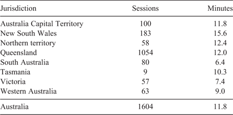
Table 3 shows Google analytics data summarising the numbers of user sessions completed on the website up to 28 February 2019. A user session is a period of time in which a user (from Australia only) interacts with the website beyond opening the home page. 1604 VegMachine.net sessions lasting an average of 11.8 min ran in this period. The higher level of use by Queensland users (66% of all sessions) reflects the better functionality and greater promotion provided in Queensland, though more than 50 sessions were completed in all Australian states and territories except Tasmania.
|
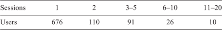
VegMachine.net has had 913 users up to February 2019 (Table 4). The number of sessions per user is highly skewed with 676 users (74%) completing one session and 36 users (4%) completing more than five sessions. These numbers show a clear demand for the service, with many users trialling it and one-quarter returning to use it again. It is worth note that repeat-use is underestimated in these data. Google identifies users by a unique combination of their device and browser. If a user operates VegMachine.net on two device/browser combinations or clears browser cookies between sessions on the same device/browser, Google counts them as two users. Consequently, one-time users and total users (Table 4) are very likely overestimated, though it is unclear by what amount. Even allowing that single-use is overestimated though, a large group of users still must not have returned after their first visit. There are several possible reasons for this, but the two most likely are that some users struggle to operate the website independently so don’t return, or some see insufficient benefit in repeat use after a first viewing. At this point in time we have no data to clarify the situation, but reducing one-time use is an obvious avenue for improving the service, and is discussed later.
|
VegMachine.net has clear potential to assist rangeland users in a variety of activities that require cover data and analysis (Cowley 2018; Russell-Smith and Sangha 2018; Chen et al. 2019), and its impact has been substantial given its recency. This is demonstrated in four case studies below, where it has been applied by users for a range of purposes.
-
VegMachine.net products are used directly in the grazing community to assist in property scale management decisions. Beef producers Dan and Emma-Jane Burnham from Stonehaven near Thangool in Queensland are one example. They use regional comparison reports to benchmark ground cover and for ‘identifying paddocks in need of more attention’ (Brinsmead 2017; QRIScloud 2018).
-
VegMachine.net is part of the extension practices of Grazing Best Management Practice (BMP) (Willis et al. 2017), a partnership between FBA, the grazing industry and the Queensland government to improve practices and sustainability in the Queensland grazing industry. Over 200 regional comparison reports have been provided to grazing enterprises participating in Grazing BMP audits and related extension activities. Enterprise managers use these reports to demonstrate their stewardship during audit, to document and interpret changes in their grazing landscape, and to communicate with family and other stakeholders in their business.
-
Several NRMs regularly use VegMachine.net analyses to engage clients and evaluate potential NRM investments. FBA has generated more than 100 PEPER reports to evaluate potential investment sites, including 20 properties where $468 000 of Reef Trust 2 funding has been invested to reduce sediment runoff. Similarly, the Mary River Catchment Coordinating Committee have used PEPER analyses on 13 investment sites where $129 000 of Reef Trust 3 funds will be invested. NQDT has used ground cover analyses and regional comparison reports on more than 50 potential investment sites for planning and client engagement.
-
VegMachine.net has provided data for several peer reviewed studies (Elledge and Thornton 2017; Saiz et al. 2018; Bird et al. 2019; Chen et al. 2019). These studies have extracted cover data from the site for both descriptive and analytical purposes, using the numeric and graphic outputs of the site.
Discussion
The rationale for developing VegMachine.net was to reach more users and provide continuity for the ageing VegMachine software. The results of that development show that is possible to deliver land cover monitoring in an accessible online format. More importantly though, the user statistics and case studies show a demand for the service and a user community with a wide range of uses for the tool. VegMachine.net has exceeded the capacity of its PC forerunner, and provided a significant advance in the ability of users to remotely monitor land cover and understand landscape change. Consequently, it has widened the scope for more sustainable management decisions, better stewardship, better NRM investment and better science in the rangelands.
Online delivery has had several advantages. As expected, a larger and more diverse user group has accessed and interrogated the ground cover archive online. Online delivery also ensures that the site interface and data are equally current for all users. Finally, although we have not compared the relative costs under PC and online delivery, ongoing support per user is certainly less time consuming and very likely less costly when delivered online.
However, lower support costs also reflect lower capacity for face-to-face user assistance. One risk of this is that users will depart the website if they cannot find adequate online support to operate the site. Whether this happened to our users is unclear, since we don’t have user survey data. It is possible that all our single visit users exited because site content was not what they wanted or were simply misclassified repeat visitors using a novel device/browser combination. However, given the large proportion of one-time users (74%) we think it is very possible that at least some users departed because they had difficulties and could not find sufficient help online. Anecdotally, users at our training events (where personal help is available) regularly request assistance, which indicates some users don’t immediately master site operation without personal help. This shows the challenge of building a single tool for a diverse user group (e.g. graziers, technicians, extension providers, scientists). Obviously, users can be better supported through more face-to-face assistance, but online delivery cannot rely heavily on personal support. Factors like website design, better connecting particular users to particular workflows, and further development of the third party support network seem likely paths for future development if one-time use is to be reduced.
Historically, graziers have had little access to the type of data VegMachine.net provides, and improved access for this group is particularly advantageous. This is because most graziers know the layout and management history of their land, and can interpret ground cover changes through that prism. Multiple studies show local knowledge assists the interpretation of remotely sensed data (e.g. Karfs et al. 2009; Lawley et al. 2016; Eddy et al. 2017). The on-ground knowledge of graziers is no exception to this finding, and grazier access through VegMachine.net creates many positive outcomes. These include informing more sustainable management decisions, improved tools for communication with stakeholders, and better ability to demonstrate stewardship to markets and regulators.
One way to increase public use of large datasets like the ground cover archive is to provide users with multiple access points. VegMachine.net is currently one of several web services that access land cover time series data (Leys et al. 2017; Russell-Smith and Sangha 2018). The costs, products and complexity of these services vary widely, but we should view the presence of multiple services as advantageous. For example, the VegMachine.net regional comparison report provides high return for effort if users have existing property mapping, since mapping can be uploaded and a report for all paddocks delivered promptly. By comparison, users without mapping must plot their paddocks in VegMachine.net before requesting the same report. This can be time consuming, and these users might prefer a less detailed land parcel report through the FORAGE website (Zhang and Carter 2018). The availability of multiple access points is beneficial for end users, and particularly less experienced users, but it also requires clear messaging to users about how services differ and whom they best suit (Whish 2016). This should be considered in future programs that promote the use of ground cover data and services.
Ground cover is one aspect of grazing land ecology, and it has some limitations that affect how it is viewed in VegMachine.net. At present the cover imagery in VegMachine.net is seasonal, so the most recent imagery is often at least three months old. This limits how well it can support short-term decisions, and consequently, the service largely focuses on longer term trends and assists longer-term decisions. Cover is often also interpreted as a surrogate for land condition. Over the longer term this relationship is reasonably reliable, particularly where consistently low levels of cover indicate poor land condition. At higher cover levels though, the cover–condition relationship is less robust, for example where increaser species are abundant. This is why cover analysis is enhanced by knowledge about species composition and other local features. There is clearly a place for additional products besides cover data. Good examples are pasture biomass and land condition, though these have proven harder to monitor remotely (Karfs et al. 2009; Kumar et al. 2015; Punalekar et al. 2018). If and when they are developed, VegMachine.net is well suited to deliver them to users. Until then it will remain important for users to consider analyses of ground cover in light of the local context at the AOI.
A core engagement strategy has been encouraging third party extension providers to operate the website for their grazier clients. As previously noted, this has benefits for both the provider and the grazier client. The large number of regional comparison reports generated by a relatively small number of users suggests both that this is happening and that the support network has room to grow. Since VegMachine.net can deliver to land managers in multiple jurisdictions with different funding and policy environments, it is unlikely any single group would have either the scope or resources to support all pastoralist users. A more segmented support network is needed, and for this reason, developing third party support networks will remain an important engagement strategy into the future.
A second strategy for future development is better connecting users to the workflows they need. This could take several forms. Improved website design can make it easier for users to extract the data and analyses they need, and so increase repeat user numbers. There is also scope to provide more and different time series data. Work is underway to deliver monthly rather than seasonal cover data, making VegMachine.net more relevant for short-term decision support, and there is also demand for other datasets like land condition and pasture biomass data. A third approach could be the development of more bespoke tools for specific user groups. The PEPER tool is one example, but there are many potential tools and analyses that would suit smaller groups of users better than those currently provided.
In the Australian rangelands VegMachine.net provides a unique capacity for public, private and institutional users to measure and understand landscape change on a range of scales. Since its inception in 2016, it has had a significant impact on how rangeland users operate. It has provided large numbers of users with a simple means of accessing a vast archive of historical landscape measurements. It has allowed users to quantify the impact of their management on their landscape, to demonstrate stewardship, to assess the potential of NRM investment at specific locations, and to extract data for scientific analysis. Despite these successes, there is still a great deal of scope to expand the size and geographic spread of the user population, and to enhance user experience. We are considering several strategies to achieve these goals.
Conflicts of interest
The authors declare no conflicts of interest.
Acknowledgements
VegMachine.net was funded by Fitzroy Basin Association through funding from the Australian Government’s Reef Program, with in-kind technical support from the Queensland Government. The Fitzroy Basin Association, NQ Dry Tropics and the Mary River Catchment Coordinating Committee shared data about their use of VegMachine.net. We would like to acknowledge the community of scientists, extension staff, NRMs and graziers who developed and trialled the original VegMachine PC software, and particularly its originators, Jeremy Wallace and Bob Karfs. Drafts of this paper were reviewed by Giselle Whish and Bob Karfs: many thanks to all.
References
Barnetson, J., Phinn, S., Scarth, P., and Denham, R. (2017). Assessing landsat fractional ground-cover time series across Australia’s arid rangelands: separating grazing impacts from climate variability. The International Archives of the Photogrammetry, Remote Sensing and Spatial Information Sciences XLII-3/W2, 15–26.| Assessing landsat fractional ground-cover time series across Australia’s arid rangelands: separating grazing impacts from climate variability.Crossref | GoogleScholarGoogle Scholar |
Bastin, G. N. (2008). Rangelands 2008: taking the pulse. National land & Water Audit on behalf of the ACRIS Management Committee, Canberra, ACT.
Beutel, T. S., and Silcock, J. (2008). Final Report for the Sustainable Management of Grazing Lands in Queensland’s Rangelands Project (Monitoring Component). Department of Primary Industries and Fisheries, Queensland.
Beutel, T. S., Karfs, R. A., Bull, A. L., Peel, L., and Wallace, J. F. (2004). VegMachine – putting pastoralists in the picture. Agricultural Science 17, 18–20.
Beutel, T., Karfs, R., Wallace, J., Trevithick, R., Scarth, P., and Tindall, D. (2015). VegMachine® in Queensland. In: ‘Innovation in the Rangelands. Proceedings of the 18th Australian Rangeland Society Biennial Conference’. Alice Springs, NT. (Ed. M. H. Friedel.) (Australian Rangeland Society: Parkside, SA)
Bird, M. I., Brand, M., Diefendorf, A. F., Haig, J. L., Hutley, L. B., Levchenko, V., Ridd, P. V., Cassandra Rowe, C., Whinney, J., Wurster, C. M., and Zwart, C. (2019). Identifying the ‘savanna’ signature in lacustrine sediments in northern Australia. Quaternary Science Reviews 203, 233–247.
| Identifying the ‘savanna’ signature in lacustrine sediments in northern Australia.Crossref | GoogleScholarGoogle Scholar |
Brinsmead, N. (2017). Let’s get technical. Introducing you to VegMachine®. Envoy 2017, 17.
Caccetta, P., Furby, S. L., O’Connell, J., Wallace, J. F., and Wu, X. (2007). Continental monitoring: 34 years of land cover change using Landsat imagery. In: ‘32nd International Symposium on Remote Sensing of Environment’. Costa Rica. (International Center for Remote Sensing of Environment: Tuscon, AZ, USA)
Chen, Y., Guerschman, J. P., Cheng, Z., and Guo, L. (2019). Remote sensing for vegetation monitoring in carbon capture storage regions: A review. Applied Energy 240, 312–326.
| Remote sensing for vegetation monitoring in carbon capture storage regions: A review.Crossref | GoogleScholarGoogle Scholar |
Clancy, T., Long, S., Christensen, B., and Gibson, A. (2013). Transforming Australian Ecosystem Science. NCRIS final report. Terrestrial Ecosystem Research Network, University of Queensland.
Cowley, R. (2018). VegMachine - Looking at the ground from the sky. Katherine Rural Review 335, 1–3.
Eddy, I. M., Gergel, S. E., Coops, N. C., Henebry, G. M., Levine, J., Zerriffi, H., and Shibkov, E. (2017). Integrating remote sensing and local ecological knowledge to monitor rangeland dynamics. Ecological Indicators 82, 106–116.
| Integrating remote sensing and local ecological knowledge to monitor rangeland dynamics.Crossref | GoogleScholarGoogle Scholar |
Elledge, A., and Thornton, C. (2017). Effect of changing land use from virgin brigalow (Acacia harpophylla) woodland to a crop or pasture system on sediment, nitrogen and phosphorus in runoff over 25 years in subtropical Australia. Agriculture, Ecosystems & Environment 239, 119–131.
| Effect of changing land use from virgin brigalow (Acacia harpophylla) woodland to a crop or pasture system on sediment, nitrogen and phosphorus in runoff over 25 years in subtropical Australia.Crossref | GoogleScholarGoogle Scholar |
FarmMap4D (2018). Fact sheet: Time series satellite data products. FarmMap4D. Available at: http://www.farmmap4d.com.au/wp-content/uploads/2018/02/Time-series-data-satellite-productsV2.pdf (accessed 12 March 2019).
Guerschman, J. P., Hill, M. J., Renzullo, L. J., Barrett, D. J., Marks, A. S., and Botha, E. J. (2009). Estimating fractional cover of photosynthetic vegetation, non-photosynthetic vegetation and bare soil in the Australian tropical savanna region upscaling the EO-1 Hyperion and MODIS sensors. Remote Sensing of Environment 113, 928–945.
| Estimating fractional cover of photosynthetic vegetation, non-photosynthetic vegetation and bare soil in the Australian tropical savanna region upscaling the EO-1 Hyperion and MODIS sensors.Crossref | GoogleScholarGoogle Scholar |
Guerschman, J. P., Scarth, P. F., McVicar, T. R., Renzullo, L. J., Malthus, T. J., Stewart, J. B., Rickards, J. E., and Trevithick, R. (2015). Assessing the effects of site heterogeneity and soil properties when unmixing photosynthetic vegetation, non-photosynthetic vegetation and bare soil fractions from Landsat and MODIS data. Remote Sensing of Environment 161, 12–26.
| Assessing the effects of site heterogeneity and soil properties when unmixing photosynthetic vegetation, non-photosynthetic vegetation and bare soil fractions from Landsat and MODIS data.Crossref | GoogleScholarGoogle Scholar |
Karfs, R. A., Daly, C., Beutel, T. S., Peel, L., and Wallace, J. F. (2004). VegMachine - delivering monitoring information to Northern Australia’s pastoral industry. In: ‘Proceedings of the 12th Australasian Remote Sensing and Photogrammetry Conference’. Fremantle, WA. (Spatial Sciences Institute: Canberra, ACT)
Karfs, R. A., Abbott, B. N., Scarth, P. F., and Wallace, J. F. (2009). Land condition monitoring information for reef catchments: a new era. The Rangeland Journal 31, 69–86.
| Land condition monitoring information for reef catchments: a new era.Crossref | GoogleScholarGoogle Scholar |
Kumar, L., Sinha, P., Taylor, S., and Alqurashi, A. F. (2015). Review of the use of remote sensing for biomass estimation to support renewable energy generation. Journal of Applied Remote Sensing 9, 097696.
| Review of the use of remote sensing for biomass estimation to support renewable energy generation.Crossref | GoogleScholarGoogle Scholar |
Lawley, V., Lewis, M., Clarke, K., and Ostendorf, B. (2016). Site-based and remote sensing methods for monitoring indicators of vegetation condition: An Australian review. Ecological Indicators 60, 1273–1283.
| Site-based and remote sensing methods for monitoring indicators of vegetation condition: An Australian review.Crossref | GoogleScholarGoogle Scholar |
Leys, J., Heidenreich, S., Koen, T., and Colson, I. (2016). DustWatch Network and Roadside Survey 2016. Report for contract WN00732. Local Land Services, New South Wales Government.
Leys, J., Chappell, A., Mewett, J., and Barson, M. (2017). Wind Erosion Assessment for National Landcare Program. NSW Office of Environment and Heritage, Australia.
Peel, L. J., Beutel, T. S., Bull, A. L., Karfs, R. A., and Wallace, J. (2006). NBP.315 VegMachine – Extending Integrated Rangeland Monitoring Information to Industry. Meat and Livestock Australia, North Sydney, NSW.
Punalekar, S. M., Verhoef, A., Quaife, T. L., Humphries, D., Bermingham, L., and Reynolds, C. K. (2018). Application of Sentinel-2A data for pasture biomass monitoring using a physically based radiative transfer model. Remote Sensing of Environment 218, 207–220.
| Application of Sentinel-2A data for pasture biomass monitoring using a physically based radiative transfer model.Crossref | GoogleScholarGoogle Scholar |
QRIScloud (2018). QRIScloud delivers satellite data to Australian farmers, government and the public. Available at: https://www.qriscloud.org.au/about-qriscloud/case-studies/item/82-qriscloud-delivers-satellite-data-to-australian-farmers-govt-and-the-public (accessed 12 March 2019).
Queensland Government (2018). Reef 2050 Water Quality Improvement Plan 2017–2022. Available at: https://www.reefplan.qld.gov.au/about/assets/reef-2050-water-quality-improvement-plan-2017-22.pdf (accessed 12 March 2019).
Ramoelo, A., Stolter, C., Joubert, D., Cho, M. A., Groengroeft, A., Madibela, O. R., Zimmermann, I., and Pringle, H. (2018). Rangeland monitoring and assessment: a review. In: ‘Climate Change and Adaptive Land Management in Southern Africa – Assessments, Changes, Challenges, and Solutions’. (Eds R. Revermann, K. M. Krewenka, U. Schmiedel, J. M. Olwoch, J. Helmschrot and N. Jürgens.). Biodiversity & Ecology 6, 170–176. (Klaus Hess Publishers: Göttingen and Windhoek.)
Reeves, M. C., and Baggett, L. S. (2014). A remote sensing protocol for identifying rangelands with degraded productive capacity. Ecological Indicators 43, 172–182.
| A remote sensing protocol for identifying rangelands with degraded productive capacity.Crossref | GoogleScholarGoogle Scholar |
Reeves, M. C., Robert, A., Angerer, J., Hunt, E. R., Jr, Wasantha, R., and Kumar, L. (2015). Global View of Remote Sensing of Rangelands: Evolution, Applications, Future Pathways. In: ‘Land Resources Monitoring, Modeling, and Mapping with Remote Sensing’. pp. 237–266. (CRC Press/Taylor and Francis Group: Boca Raton, FL, USA.)
Renard, K. G., Foster, G. R., Weesies, G. A., McCool, D. K., and Yoder, D. C. (1997). ‘Predicting Soil Erosion by Water: A Guide to Conservation Planning with the Revised Universal Soil Loss Equation (RUSLE).’ USDA, Agriculture Handbook No. 703. (United States Department of Agriculture: Washington, DC.)
Russell-Smith, J., and Sangha, K. K. (2018). Emerging opportunities for developing a diversified land sector economy in Australia’s northern savannas. The Rangeland Journal 40, 315–330.
| Emerging opportunities for developing a diversified land sector economy in Australia’s northern savannas.Crossref | GoogleScholarGoogle Scholar |
Saiz, G., Goodrick, I., Wurster, C., Nelson, P. N., Wynn, J., and Bird, M. (2018). Preferential production and transport of grass-derived pyrogenic carbon in NE-Australian savanna ecosystems. Frontiers of Earth Science 5, 115.
| Preferential production and transport of grass-derived pyrogenic carbon in NE-Australian savanna ecosystems.Crossref | GoogleScholarGoogle Scholar |
Scarth, P., Röder, A., and Schmidt, M. (2010). Tracking grazing pressure and climate interaction – the role of Landsat fractional cover in time series analysis. In: ‘Proceedings of the 15th Australasian Remote Sensing and Photogrammetry Conference (ARSPC)’. 13–17 September, Alice Springs, NT. pp. 13–17. (Spatial Sciences Institute: Canberra, ACT)
Scarth, P., Guerschman, J. P., Clarke, K., and Phinn, S. (2015). Validation of Australian Fractional Cover Products from MODIS and Landsat Data. AusCover Good Practice Guidelines: A Technical Handbook Supporting Calibration and Validation Activities of Remotely Sensed Data Product, 123–138.
Stewart, J. B., Rickards, J. E., Randall, L. A., McPhee, R. K., and Paplinska, J. Z. (2014). Ground cover monitoring for Australia: Final report July 2012 to June 2013. ABARES Technical report 14.1. Australian Bureau of Agricultural and Resource Economics and Sciences, Canberra.
TERN AusCover (2017a). Seasonal ground cover. Available at: http://www.auscover.org.au/purl/landsat-seasonal-ground-cover (accessed 12 March 2019).
TERN AusCover (2017b). Seasonal fractional cover. Available at: http://auscover.org.au/purl/landsat-seasonal-fractional-cover (accessed 12 March 2019).
TERN AusCover (2017c). Foliage Projective cover. Available at: http://data.auscover.org.au/xwiki/bin/view/Product+pages/qld_fpc (accessed 12 March 2019).
TERN AusCover (2017d). Seasonal persistent green cover. Available at: http://www.auscover.org.au/purl/landsat-seasonal-persistent-green (accessed 12 March 2019).
TERN AusCover (2018). Seasonal cover deciles – Landsat. Available at: (http://www.auscover.org.au/purl/landsat-seasonal-cover-deciles (accessed 12 March 2019).
TERN AusCover (2019). Seasonal fractional cover – Sentinel-2. Available at: http://data.auscover.org.au/xwiki/bin/view/Product+pages/Sentinel-2+Seasonal+Fractional+Cover (accessed 12 March 2019).
Thornes, J. B. (2007). Modelling soil erosion by grazing: recent developments and new approaches. Geographical Research 45, 13–26.
| Modelling soil erosion by grazing: recent developments and new approaches.Crossref | GoogleScholarGoogle Scholar |
Trevithick, R., Scarth, P., Tindall, D., Denham, R., and Flood, N. (2014). Cover under trees: RP64G Synthesis Report. Department of Science, Information Technology, Innovation and the Arts, Brisbane, Qld.
Wallace, J. F., Caccetta, P. A., and Kiiveri, H. T. (2004). Recent developments in analysis of spatial and temporal data for landscape qualities and monitoring. Austral Ecology 29, 100–107.
| Recent developments in analysis of spatial and temporal data for landscape qualities and monitoring.Crossref | GoogleScholarGoogle Scholar |
Whish, G. (2016). Accelerating the use of FORAGE and other complementary tools to support sustainable grazing land practices. DAF Final Report 3214B. Department of Agriculture and Fisheries, Queensland.
Willis, M., Nelson, B., and Brown, K. (2017). Extension through Grazing BMP: An integration of production and natural resource management. Rural Extension and Innovation Systems Journal 13, 156.
Zhang, B., and Carter, J. (2018). FORAGE – An online system for generating and delivering property-scale decision support information for grazing land and environmental management. Computers and Electronics in Agriculture 150, 302–311.
| FORAGE – An online system for generating and delivering property-scale decision support information for grazing land and environmental management.Crossref | GoogleScholarGoogle Scholar |