

Feral horses (Equus caballus) increase suspended sediment in subalpine streams
Peter Raymond Scanes A C , Adam McSorley B and Adrian Dickson A
A Estuary and Catchments Science, Science, Economics and Insights Division, Department of Planning Industry and Environment, NSW, 480 Weeroona Road, Lidcombe, NSW 2142, Australia.
B Department of Planning Industry and Environment, Pests and Weeds Unit, NSW National Parks and Wildlife Service, 12 Darcy Street, Parramatta, NSW 2150, Australia.
C Corresponding author. Email: peter.scanes@environment.nsw.gov.au
Marine and Freshwater Research 72(9) 1290-1302 https://doi.org/10.1071/MF20353
Submitted: 8 December 2020 Accepted: 2 March 2021 Published: 19 April 2021
Journal Compilation © CSIRO 2021 Open Access CC BY-NC
Abstract
Feral horses preferentially utilise aquatic landscape elements. Damage to stream banks by feral horses potentially degrades water quality and affects aquatic ecosystems. Despite the global predominance of horse activity in or near water, there is poor understanding of in-stream impacts. Motion-sensing cameras were used near subalpine streams to quantify frequency and behaviour of horses interacting with streams. Deployed turbidity loggers were used to indicate the presence of suspended sediment from interactions and to assess long-term (3 year) seasonal suspended sediment regime at sites with very small and large amounts of horse activity. In summer, 99.9% of large grazer interactions with streams were horses and we estimate 130 horse interactions per kilometre of stream per day, resulting in stream turbidity increases up to 100 NTU. Long-term turbidity at sites with greater riparian damage from horses was significantly greater than at control sites. Turbidity in horse-affected streams peaked at 50 times the national turbidity guideline and, in summer, averaged eight times the guideline. Suspended sediment leads to a high risk of loss of aquatic diversity and impairment of ecosystem function. Linear relationships between turbidity and riparian damage suggest that any level of horse presence affects subalpine waterways.
Keywords: suspended sediment, turbidity, riparian damage, stream ecology, feral horses.
Introduction
Populations of feral horses have established in numerous countries across North America, Oceania, Europe, South America, Africa and central Asia (Eldridge et al. 2020). Feral horses have been shown to cause a wide range of environmental and ecological harm including loss of native species, introduction and facilitation of weeds and damage to riparian zones and stream banks (Driscoll et al. 2019). Eldridge et al. (2020) reviewed global impacts and concluded that feral horse activity reduced environmental values and that the degree of harm increased as horse activity increased. Feral horses have adapted to a wide range of habitats, including arid, riparian, wetlands and alpine. Across these habitats, the effects of horses are not evenly distributed in the landscape. Horses favour valley bottoms, wetlands, peatlands, stream-side areas and other open areas with low vegetation, usually associated with water (Dyring 1990; Rogers 1994; Crane et al. 1997; Dawson 2009). Concentrated horse activity in these landscape elements increases the risk of detrimental impacts (Eldridge et al. 2020). However, the literature available on global horse impacts is focussed on terrestrial settings. Despite the global predominance of horse activity in or near landscape elements associated with water, there is a very poor understanding of in-stream impacts on those water bodies.
The impacts of large grazing animals near to streams have been well documented (Kauffman et al. 1983; Kauffman and Krueger 1984) and include bank erosion, slumping and undercutting of banks (Dyring 1990), increased runoff (Dyring 1990; Rogers 1994) and acceleration of gully erosion (Berman and Jarman 1988). Riparian damage increases nutrient runoff into streams (Airaksinen et al. 2007) and physical damage by hoofs break and slump banks, leading to large inputs of unconsolidated soils into waterways (Robertson et al. 2019). Increased siltation of river substrates can significantly affect fish spawning, as has been demonstrated for the critically endangered fish Galaxias tantangara (Driscoll et al. 2019). Open boggy habitats that retain water in subalpine landscapes and provide critical habitat (Hope et al. 2012) can also be altered by free-ranging horses (Dyring 1990; Rogers 1991; Clemann 2002; Pittock and Finlayson 2018), mainly through soil compaction on tracks and pugging (indentations from hoof pressure). Decreases in physical and chemical water quality (Nimmo and Miller 2007), changes to stream flow and increases in siltation (Rogers 1991) are reported for waterways, although no data are presented. A consequence of riparian damage is a decline in ecosystem integrity of in-stream and riparian habitats. Poor understanding of feral horse impacts on instream habitats prevents proper assessment of ecological consequences and implications for water quality and water supply. Although a link to poor water quality is often inferred, there is a marked absence of published data to quantify impacts. This will be the focus of our study.
In the Australian Alps, and in particular Kosciuszko National Park, parts of the alpine, subalpine and montane (hereafter referred to as subalpine) areas are now threatened by rapidly increasing populations of feral horses (Equus caballus, Linnaeus, 1758; Driscoll et al. 2019). At the time of our study (2019), horse populations in the Australian Alps were estimated at 25 318 animals (3.4 animals km−2), an increase from 9187 in 2014 at a rate of 23% per annum (Cairns 2019). In northern Kosciuszko region, feral horses increased in abundance from 3255 in 2014 to 15 687 in 2019 at a rate of 37% per year (Cairns 2019).
Habitat degradation and loss due to feral horses is listed as a key threatening process for alpine ecosystems in the New South Wales Biodiversity Conservation Act (2016). High-intensity usage of stream banks by feral horses results in significant changes in riparian vegetation, increases in soil compaction (which favours water runoff rather than water infiltration) and damage to soft structures such as sphagnum bogs, which, when intact, are known to slow the flow of rainfall runoff (Hope and Clark 2008) and reduce erosion (Kauffman and Krueger 1984; Dyring 1990; Rogers 1991). This is critical because the streams and wetlands of the Alps are unique ecosystems in Australia and are the source of most of the water for electricity generation and lowlands irrigation in eastern Australia (Pittock and Finlayson 2018). Similar consequences were also demonstrated as a result of cattle grazing in adjacent subalpine landscapes some decades ago, and removal of cattle followed by active rehabilitation was required to reverse many of the impacts, although some damage persists over 40 years later (Good and Johnston 2019).
The intensive usage of riparian corridors by horses has a secondary impact of trampling and compaction of subalpine grasslands and wetlands. The vegetation damage leads to the loss of critical habitat for threatened animal species such as broad-toothed rat, various alpine skinks, alpine spiny crayfish, alpine tree frog and corroboree frog (Clemann 2002; O’Brien et al. 2008; Driscoll et al. 2019; Eldridge et al. 2019). Robertson et al. (2019) measured nine variables of soil and stream stability and vegetation cover at stratified random sites on high-altitude treeless plains, and horse-occupied sites had significantly poorer outcomes for all stream stability and soil variables.
This paper focuses on changes to suspended fine sediment (measured as turbidity) and stream ecology resulting from the actions of horses in or near subalpine streams. There is some dispute about whether horses are responsible for the damage observed (Driscoll et al. 2019), so confirmation of the role of horses versus other animals is also an important component.
Suspended fine sediment and siltation in affected subalpine waterways are consequences of introduction of soils from riparian and streambank degradation (Robertson et al. 2019) and are exacerbated through resuspension of bed sediments when horses are active within the stream. Horse use of riparian zones also leads to the loss of streambank vegetation (Robertson et al. 2019), which typically overhangs streams and provides habitat, refugia and shading (Pusey and Arthington 2003; Marsh et al. 2005). The net result is potential changes to water clarity, suspended sediment loads, water temperature, conductivity of waters, habitat availability and carbon and nutrient sources and cycling through ecosystems (Pusey and Arthington 2003). Changes to fine and coarse sediment and water inputs, and in-stream habitats, have the potential to lead to profound changes in stream ecology and, potentially, biodiversity and structure of aquatic invertebrates, fish assemblages and productivity of streams (Pusey and Arthington 2003). Studies of direct impacts of cattle grazing have shown that it leads to changes in structure of aquatic invertebrate communities (Conroy et al. 2016). There are also indirect effects of horses on mobile invertebrates and fish (e.g. Levin et al. 2002). Horses have been identified as a major threat to one critically endangered Australian fish, namely, stocky galaxias (Galaxias tantangara; Allan and Lintermans 2018; Driscoll et al. 2019), through increased siltation of spawning substrate.
Despite the prevalence of correlative evidence about impacts of horses on water quality (Paull 2018; Pittock and Finlayson 2018; Driscoll et al. 2019), we cannot find any published studies with direct measurements of changes to physical and chemical properties of water as a result of feral horse interactions with streams. This paper addresses the following four primary questions:
-
Are feral horses the principal grazers interacting with subalpine riparian and stream systems?
-
Does horse activity in and on the banks of streams increase the suspended sediments (as indicated by turbidity) of those streams and damage the banks and riparian zone?
-
What are the differences in turbidity among sites and seasons, and the frequency of turbidity above Australian and New Zealand Guidelines for Fresh and Marine Water Quality (ANZG 2018) at each site?
-
Is the turbidity experienced likely to lead to ecological harm?
Materials and methods
Our study area is the northern part of Kosciuszko National Park, New South Wales (NSW), Australia (35.57°S–35.87°S, 148.47°–148.67°). The landscape is a dissected subalpine (altitude 1200–1400 m) plateau with broad flat valleys containing extensive sphagnum wetlands and generally narrow low-gradient streams. Soils are predominantly sandy alpine humus loams with peat lithosols in wetlands (Eldridge et al. 2019). The valleys are tree-less grass plains and the intervening low ridges support woodlands dominated by cold-adapted eucalypt trees. Temperatures range from –0.7°C to 34°C (mean 21.7°C) in austral summer (January) to −6.8°C to 11.8°C (mean 3.9°C) in austral winter (July); (1996–2020 data for Cabramurra, Site Number 072 161, Australian Bureau of Meteorology). All study sites are within a 15 km radius on this broad, low-relief plateau and have similar soils, surrounding vegetation, elevation, catchment areas and distance to source (and, hence, flow characteristics), stream size and rainfall (Table 1, Fig. 1).

|

|
Study sites (Fig. 1) were chosen to represent a gradient of horse activity. Putative horse activity was based on results from published horse occupation maps (NPWS 2008), surveys of dung density (Eldridge et al. 2019) and information from Park Rangers. Bullocks Head Creek (BH1) and Eucumbene River (ER1; Fig. 1) are expected to have little or no near-stream horse activity; Murrumbidgee River (MR1) and Mosquito Creek (MC1) and two secondary sites (MR3 and MC2) are expected to have high levels of riparian horse activity (Table 1). Bullocks Head Creek and Eucumbene River sites were burnt by intense wildfires on 4 January 2020. As a consequence, only data from before 1 January 2020 are presented in comparative analyses of low and high horse use sites (Question 3 below). The analysis of whether direct horse interactions resulted in turbidity at Murrumbidgee River and Mosquito Creek sites includes data up to 20 February 2020, as the catchments of these sites were not burnt.
Throughout this paper, turbidity is used as a surrogate for the mass (or load) of fine suspended sediment. So as to confirm the relationship between turbidity and suspended sediments, samples of stream water were collected in April 2019 to determine the relationship between turbidity and the mass of suspended sediments present in waters. Water samples from MC1, MR1, ER1 and BH1 plus other sites (A. Dickson, P. Scanes, unpubl. data) were collected by submerging a 2-L container in the water and allowing it to fill with subsurface water. Samples were kept cool and dark until analysis. Prior to filtering, containers were shaken vigorously to resuspend material and turbidity of the samples was determined using a laboratory turbidity meter (Hach 2100P, USA). The mass of sediment was determined by filtering the sample onto a pre-weighed glass-fibre filter (2 μm pore size), oven drying at 105°C to a constant weight and then re-weighing to determine the mass of sediment on the filter. The mass of organic sediment was determined by firing the filter in an oven at 320°C and reweighing to determine the mass of organic material lost on ignition.
(1) Are feral horses the principal grazers interacting with subalpine riparian and stream systems?
We used infrared motion sensing camera traps (Reconyx Hypefire PC800, USA) to record the presence of animals near waterways at four sites in areas where horses were known to be present (MC1, MC2, MR1, MR3) and at one site presumed to have no horses (BH1). Cameras were put in place 10–11 December 2019 and retrieved 20 February 2020. There were three cameras deployed at each of MC1 and MR1 and single cameras at MC2 and MR3 and BH1. Cameras were placed to record animal interactions with water and activities on stream banks immediately upstream of stream turbidity loggers (see below). Each camera included ~20–30 m of stream and bank in its field of view.
Images from each camera were grouped into detection events consisting of consecutive images of the same species within 10 min performing the same interaction with the stream. All images were viewed and tagged using ExifPro 2.1 (Kowalski and Kowalski 2015). We recorded the species present, the stream interaction type (Crossing, moving from one bank to another without stopping; Stream, other forms of contact with the water; Bank, present but not making contact with water, e.g. grazing or walking along banks) and the number of individual animals involved in the interaction. When detection events had multiple interaction types Stream and Crossing were recorded rather than Bank interactions. Only large grazers (e.g. horse, deer, pigs) were assessed because previous work (Robertson et al. 2019) showed that small native and introduced grazers (e.g. kangaroos, rabbits) do not cause riparian damage, nor do small carnivores (e.g. foxes, dogs).
(2) Did horse activity in streams and on the banks of streams increase suspended sediments (as indicated by turbidity) of those streams and damage the banks and riparian zone?
To assess whether specific horse interactions led to concomitant increases in stream turbidity, we deployed calibrated turbidity loggers (Observator NEP495, Australia) at three of the horse-affected camera sites (MC1, MC2, MR1) and one low horse-use site (BH1). The loggers record turbidity and temperature and have an in-built wiper to ensure that the sensor is kept clean of any aquatic fouling or sediment. Turbidity loggers were calibrated for their lower range to measure the very low turbidity expected in subalpine streams (1–4 NTU). At this calibration setting, the loggers are unable to accurately distinguish values greater than 90 NTU and record a maximum value of ~100 NTU in these conditions. Loggers were ~5–10 m downstream of the most downstream camera. They were deployed in a shallow (~0.5 m deep) section within the stream in a housing that suspended the logger horizontally ~200 mm above the substrate. Sensors faced upstream and were set to record data at 3.5-min intervals.
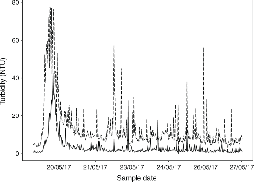
Turbidity can also increase after rainfall due to suspended sediments in runoff and remobilisation of benthic sediments by water flow. It is expected that horse-affected streams with disturbed riparian boundaries and greater benthic sediment loads would have greater turbidity after rain than do streams that have no horse-related disturbance and intact riparian areas. On 20 May 2017, there was an isolated rainfall event when 39 mm of rain fell in the study region (Bureau of Meteorology, Rainfall Station 72 141, Yarrangobilly Caves) at a time when there had been very little rain in the preceding 3 weeks. Data from turbidity loggers that were already deployed at BH1 and MC1 were compared to determine whether horse disturbance also increased post-storm turbidity.
Riparian damage from long-term horse activity at each site was determined quantitatively using the methods of Robertson et al. (2019) to assess disturbance within a single 50 × 20 m (10 m either side of stream) riparian area at each site. Soil compaction was also measured directly by inserting a portable dial penetrometer (Penetrometro ST207, Italy) into soil 20 times at haphazardly selected places distributed over each site.
(3) What are the differences in turbidity among sites and seasons, and the frequency of turbidity above guideline values at each site?
Long-term turbidity was measured using the same turbidity loggers (Observator NEP495, Australia). Deployments were made from May 2017 to February 2020, but were not continuous in that period (Supplementary material Table S1, available at the journal’s website). Loggers collected data every 30 min for the majority of the sampling time (Table S1). Turbidity loggers were calibrated before deployment, and, after deployment, they were checked against each other and a calibrated multiprobe (YSI EXO2 or ProDSS, USA) to assess consistency and calibration drift during deployment. Drift was less than 1 NTU and no corrections to raw data were necessary. Data were quality assured to remove anomalous data points (individual data points >3 standard deviations, rapid fluctuations) and sensor malfunction. Deployments were at BH1 (no horse activity in streams), ER1 (minimal horse activity in streams), MR1 (substantial horse activity in streams), and MC1 (substantial horse activity in streams).
(4) Is the turbidity likely to lead to ecological harm?
Whether the turbidity that we measured was likely to lead to alteration of in-stream ecological outcomes was assessed using the existing National Water Quality Management Strategy (NWQMS) Water Quality Guidelines (Australian Government 2018). It is important to note that turbidity is the measure used in the guidelines to indicate a risk to ecological health from suspended fine sediment. Guidelines are designed to assist with risk management and indicate that, above a certain level, there may be an impact on ecological condition. Turbidity was compared with guideline values (GVs) for physical and chemical stressors from the Australian and New Zealand Guidelines for Fresh and Marine Water Quality (ANZG 2018). The guidelines used to indicate ecological risk were Victorian Alpine Guidelines, which were developed specifically for the Australian alpine and subalpine region.
Statistical analysis
The relationship between turbidity and suspended solids was determined by linear regression of turbidity and suspended solids in each sample.
-
Question 1: The number of detection events per species (regardless of stream interaction type) was used to estimate the relative potential to affect waterways. Data are presented as total number of interactions and the percentage of events attributed to each species.
-
Question 2: A random subsample of 8–10 consecutive days in December 2019 was examined in detail for one camera at each site. The change in turbidity being logged at that site was recorded at each detection event, and the short-term temporal pattern and intensity of turbidity change for each type of interaction were noted. This provided detailed information on the turbidity generated by different types of interaction.
To determine whether increases in turbidity occurred concurrently with animal interactions, the time of occurrence of all Stream and Crossing detection events was graphically compared with the equivalent times in the turbidity record for the duration of camera deployments.
The relationship between number of animals in a detection event and the size of turbidity spikes was examined using generalised linear model (GLM) regression.
Raw scores from the Robertson et al. (2019) assessment method were normalised to create a disturbance metric (0, no disturbance; 1, maximum possible disturbance) by calculating the difference between the raw score (from field assessment) and the best possible raw score (i.e. 38 = the sum of the highest possible scores for every question) divided by the greatest possible difference from best score (i.e. 23 = (38 – sum of lowest possible scores for every question); e.g. if the field assessment of a site resulted in a score of 19, then the disturbance grade = (38 –19)/23 = 0.826). For some comparisons, scores from the nine individual indices were grouped into functional groups, including animal presence, vegetation and bank and channel morphology.
Question 3: A random subset of the long-term turbidity data was created because there were unequal numbers of data points among sites and seasons, which violates one of the main assumptions of parametric statistics (Underwood 1997; see the Supplementary material text S1). Statistical analyses (NCSS 2020) of turbidity data addressed the following two hypotheses:
-
Hypothesis 1: there are no differences in turbidity among sites, nor among season
A two-factor ANOVA was used to test for differences in mean turbidity among sites (fixed; d.f. = 3) and seasons (fixed; d.f. = 3) and interactions (d.f. = 9; MSE d.f. = 1059). Where ANOVA showed significant effects of season and/or site on mean turbidity, post hoc tests (Tukey–Kramer, TK) were used to determine whether mean turbidity for sites differed among seasons; and to test whether mean turbidity for seasons differed among sites.
-
Hypothesis 2: that the frequency distribution of turbidity does not differ among sites or seasons, and that the frequency of turbidity values greater than guidelines does not differ among sites and seasons
Percentile curves were generated to present the distributions of turbidity values for sites and seasons. Distributions of turbidity were compared using Fisher’s exact test to determine whether the turbidity distribution profiles differ significantly among sites within a season, and at each site among seasons.
Results
The relationships between turbidity and concurrently measured suspended sediments were significant and very strong (n = 25; P < 0.05, r2total = 0.97, r2mineral = 0.84, r2organic = 0.98). Suspended sediments were, on average, 74% organic and 26% mineral by weight. Using the derived relationships, turbidity of 10, 25, 50, 100 NTU represents ~6, 15, 30, 60 mg L−1 suspended sediments (respectively).
(1) Are feral horses the principal grazers interacting with subalpine riparian and stream systems?
The camera at BH1 (putatively no horse activity) was damaged by fire on 4 January 2020, but it was possible to retrieve images from the memory card. In the 24 days before loss, there were no large grazers detected. Cameras at putatively high horse-activity sites (MC1, MC2, MR1 and MR3) recorded a total of ~1800 detection events in the 30 m field of view of the cameras. Data were recorded for 216 camera days. Lost days were due to full memory cards, vegetation and vandalism. There were detection events in the 30 m field of view on ~2/3 of the 216 days recorded (Mosquito Creek 66% (range 41–86%), Murrumbidgee River 69% (range 52–87%) of days). Of these, all but two events (99.9%) were due to horses, and both non-horse events were deer at one site only (MR1). No other large feral animals (e.g. pigs) were observed.
Most detection events were classified as Bank (59%) followed by Crossing (20%) then Stream (21%). The large percentage of bank events was primarily due to the same horses spending large amounts of time grazing in the vicinity of the cameras. The maximum number of unique individual horses in a detection event was 17; however, only 24 events had 10 or more individuals. There was a mean of 2.5 (s.d. ± 2.2) individuals per event and 4.8 events per camera per day.
(2) Did horse activity in and on the banks of streams increase the suspended sediments (as indicated by turbidity) of those streams?
Analysis of the subset of turbidity logger and camera data showed that horse interactions with streams were clearly linked to turbidity. Each horse interaction resulted in a peak in turbidity, with magnitudes ranging from 10 to 90 NTU (Table S2) and lasting from less than 5 min to over 6 h (Table S2). The magnitude and duration of turbidity peaks was dependent on the type of interaction. Interactions ranged from a single horse crossing to multiple horses remaining in or interacting with the stream for an extended period of time, either continuously (typically 15–30 min) or having multiple interactions over extended periods (1–5 h; Table S2).
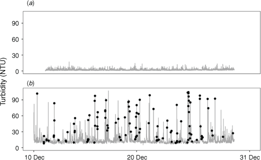
Analysis of the full turbidity dataset from 10 to 28 December 2019 for all camera deployments confirmed the trends seen in the detailed subsample. No interactions were observed at the low horse-activity site and turbidity was low with no large peaks (Fig. 2a). At the high-use site, there was a clear concurrence between animal interactions with streams and turbidity in streams (Fig. 2b, see also Supplementary material Fig. S1). Some interactions did not cause high turbidity and occasional turbidity peaks occurred with no interactions observed on our cameras. However, most interactions, particularly intense or extended interactions, led to increased turbidity, with turbidity often reaching the maximum for the selected range on the logger (90–100 NTU). The turbidity spikes associated with stream interactions ranged from 5.3 to 105 NTU with a mean of 35 NTU (95% CI = 31–39). No significant rain fell in this period (Daily Rainfall, Yarrongobilly, Station Number 72141, Australian Bureau of Meteorology).
|
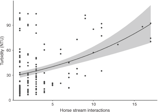
The number of horses interacting with the stream is a significant predictor of the size of the turbidity spikes (chi-square test, P < 0.001), but explains only 11% of the variation (Fig. 3). For horse groups of four or more, turbidity increases as the number of animals increases and never results in low turbidity. However, groups of three or fewer individuals can result in low turbidity, but can also create maximum turbidity, depending on their activity.
|
Post-rainfall turbidity at Bullocks Head Creek (no horse activity; 45 NTU) was considerably less than that at Mosquito Creek (substantial horse activity; 80 NTU; Fig. 4). At Bullocks Head Creek, turbidity also took longer to increase and was quicker to decline than at Mosquito Creek. Turbidity at Bullocks Head had reduced to pre-rainfall conditions within 2 days, but, at Mosquito Creek, had still not returned to pre-rain condition 7 days after rain (data no presented).
|
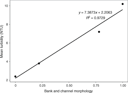
For all measures of riparian condition (scores or normalised disturbance index, Table S3), there is a clear gradient from sites with no or minimal horse presence (Bullocks Head Creek, Eucumbene) to sites with a large horse presence (Murrumbidgee River, Mosquito Creek). The bank and channel subindex (Table S3) showed a very strong linear relationship with annual mean turbidity (Fig. 5).
|
These measures showed differences in degree of horse disturbance that are consistent with the photographic analysis that showed more stream interactions at Mosquito Creek than at Murrumbidgee. The disturbance index was used as a proxy for horse presence and disturbance in subsequent analyses.
Riparian soil compaction was strongly related to horse disturbance (animal presence and vegetation subindices and summed scores; P < 0.05; r2 = 0.96) and increased as disturbance increased.
(3) What are the differences in turbidity among sites and seasons, and frequency of turbidity measurements above guideline values at each site?
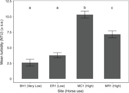
There were significant seasonal and site differences in turbidity (ANOVA, P < 0.0001). There was also a highly significant interaction term. Overall, turbidity is low and constant all year round in the Eucumbene River and Bullocks Head Creek (sites with low or no horse activity). Turbidity at Eucumbene River was slightly (but not significantly, TK, P > 0.05) greater than at Bullocks Head Creek. Overall mean turbidity was significantly greatest (TK, P < 0.05) at Mosquito Creek and intermediate at Murrumbidgee River (Fig. 6).
|
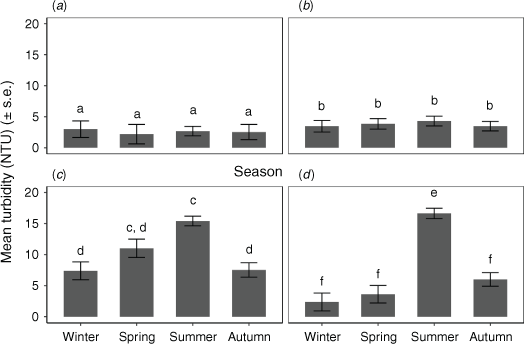
There were no significant differences among seasons for Bullocks Head Creek or Eucumbene River (Fig. 7); at Murrumbidgee River, turbidity was significantly greatest in summer, and at Mosquito Creek, it was greatest in spring and summer. Among sites within seasons (Fig. S2), Mosquito Creek and Murrumbidgee River had significantly greatest turbidity in autumn and summer, Mosquito Creek had significantly greatest turbidity in spring and there were no significant differences among sites in winter, although turbidity was greatest at Mosquito Creek.
|
There was a strong link between overall turbidity and riparian horse damage (as measured by the riparian disturbance scores) at the four sites monitored. Mean annual turbidity had a positive linear relationship with bank and channel subindex (P < 0.001, r2 = 0.97; Fig. 5; Table S3) and overall riparian damage score (P < 0.001, r2 = 0.94), whereas bank damage subindex had a negative exponential relationship with percentage of summer turbidity values that were less than guideline values (r2 = 0.99; Fig. S3).
In all seasons, frequency distributions of turbidity at Mosquito Creek (horse affected) were more strongly skewed towards larger turbidity than expected (compared with a hypothesis of no difference among distributions; Fig. S4 and Table S4); Murrumbidgee River (horse affected) showed a similar trend in all seasons except winter. In spring, summer and autumn, distributions at Bullocks Head (not horse affected) were skewed towards less turbidity than was expected. Murrumbidgee River (horse affected) had the greatest percentage of low values in winter, but Bullocks Head and Eucumbene had the greatest percentage in all other seasons (Fig. S4). Conversely, Murrumbidgee River (horse affected) had the lowest percentage of small turbidity values in summer and autumn (Fig. S4).
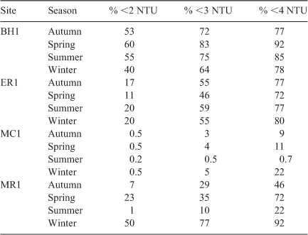
Overall compliance with national guideline values for turbidity was greatest at Bullocks Head Creek, followed by Eucumbene River, Murrumbidgee River (except summer) and Mosquito Creek (Table 2).
|
Discussion
We have shown that over a 10-week period in summer, horses were responsible for 99.9% of large grazer interactions with streams, and the horse interactions led directly to increased turbidity in streams. Long-term turbidity in horse-affected streams peaked at up to 50 times the national guideline value, and in summer months average turbidity was eight times greater than the guideline value. We conclude that the risk of ecological harm from this turbidity and associated deposited sediments is very high.
These conclusions were reached by addressing the following four specific questions:
Are feral horses the principal grazers interacting with sub-alpine riparian and stream systems?
Over 1800 large grazer interactions were photographed over 216 days and 99.9% at one site and 100% at the other three sites were by horses. At the site expected to have no horses in the riparian zone, Bullocks Head Creek, no large grazers were observed in 24 days of camera deployment. There have been consistent arguments that any damage to waterways is not due to the actions of horses, but by other large grazers such as deer and pigs (Eldridge et al. 2020). Our results indicated that the overwhelming majority of large grazer visits are by horses and provide no support for the idea that deer and pigs cause riparian damage or suspended sediment at our study sites. This is consistent with the findings of Driscoll et al. (2019), who synthesised observations across several studies, and the field studies by Robertson et al. (2019).
Did horse activity in and on the banks of streams increase the suspended sediments (as indicated by turbidity) of those streams?
Damage to riparian vegetation and bank and stream morphology was proportional to horse activity. The main forms of damage were close grazing of riparian grasses, crushing and pugging of banks and erosion at crossing points. However, horse activity is not evenly distributed within riparian strips. Horses tend to follow defined tracks as they move (Robertson et al. 2019), and when these lead to established stream crossing points, it concentrates impacts (Dyring 1990). In heavily used areas, crossings and access points can occur every 5–10 m for extended lengths of stream bank (P. Scanes, A. Dickson, pers. obs.). Our cameras had a field of view of ~30 m and were randomly allocated with respect to access points. They allowed quantification of stream interactions at multiple access points as well as at intervening less favoured sections of bank. We estimated that during summer 2019–2020, there were ~130 stream interaction events by horses per kilometre of stream (includes both banks) per day in the upper Murrumbidgee River and Mosquito Creek areas, with an average of 2.5 individuals per event. Of these 130 events, 77 would be confined to the bank, and 53 involved contact with water. Bank events have potential to result in physical damage and soil deposition in streams (Robertson et al. 2019), and stream contact events have potential to directly generate turbidity through disturbance of sediments already in streams. We observed that there are many tens of kilometres of riverbank present in the valleys used by horses over our broader study area of northern Kosciuszko National Park, and many more kilometres in other parts of the subalpine areas. Much of the immediately surrounding area is already being used intensively by horses and resembles the riparian areas sampled in our study, other parts represent opportunity for expansion as horse abundances increase. This represents a significant potential for intensive disturbance of riparian and aquatic ecosystems over a large spatial scale.
Turbidity loggers deployed downstream of cameras showed directly that stream interactions resulted in increases in turbidity. Simulation experiments showed that turbidity plumes with an intensity equal or greater than the mean summer concentration would be detectable 230 m from a disturbance site (see the ‘Spatial extent of turbidity’ section and Fig. S5). It was clear that turbidity is strongly dependant on horse behaviour while interacting with streams, and that a single animal can, in some circumstances, cause as much turbidity as does a group of 17 horses. Turbidity was significantly related to the number of horses involved in interaction events, the nature of the interaction (e.g. crossing, drinking, pawing) and the time that horses spent interacting. Intense or extended interactions frequently resulted in turbidity in excess of 90 NTU for long periods of time (hours). These findings are consistent with international studies of other large grazer interactions with streams (Kauffman et al. 1983; Kauffman and Krueger 1984).
When relating turbidity to direct stream interactions (Fig. 2b), there were some peaks that were not associated with any stream interactions recorded by our cameras in the 30 m field of view. We demonstrated that turbidity spikes can travel hundreds of metres (and probably further for extended events; see the Supplementary material Text S2, Fig. S5), and that over 99% of camera records are of horses interacting with streams. The most likely explanation is, therefore, that these additional peaks are the result of horse interactions with the stream that occurred out of the field of view of the cameras. Most interactions that did not result in a large increase in turbidity (that was observable at the scale of Fig. 2b) were the lower-intensity ‘stream’ interactions, which tend to be more subtle and result in less intense and shorter turbidity plumes.
Elevated turbidity is a recognised occurrence in streams after intense rainfall, and is caused by suspended sediments in runoff and re-suspension of in-stream sediments by increased water velocity. Runoff-related turbidity peaks in streams with intact catchments are less intense and of shorter duration than those with disturbed catchments (Cornish 2001; Scanes et al. 2007). After rainfall, turbidity in a horse-affected stream was almost double that in the control stream and increased more quickly and decreased much more slowly, indicating that horse-related damage (removal of ground cover, damage to banks and deposition of soils in streams) exacerbates rainfall-related turbidity (Fig. 4).
What are the differences in turbidity among sites and seasons, and frequency of turbidity measurements above guideline values at each site?
Spring, summer and autumn turbidity was significantly elevated at sites with the greatest horse-related riparian damage. Seasonal patterns in stream turbidity were apparent only at horse-affected sites. Horse interactions (as indicated by turbidity) are most intense in summer and autumn and least intense in winter. Further work is needed to determine whether this is due to horses leaving the open plains in winter or whether they just interact less with streams.
Australia’s National Water Quality Management Strategy (NWQMS) provides guideline values for physical and chemical stressors that, if not exceeded, will maintain biological diversity in the system (ANZG 2018). Turbidity at horse-affected sites in summer was greater than the guideline value (2 NTU) for 99 to 99.8% of samples, whereas at the control site with no horse activity, it was above the guideline value 45% of the time, much of this by a small amount. If we compare to 4 NTU as a slightly elevated alternative guideline value, sites with none or low horse activity exceeded between 15 and 23% of the time, but sites with extensive horse activity exceeded 78–99% of the time.
Is the turbidity likely to lead to ecological harm?
Turbidity is identified as having potential to affect biological diversity and ecosystem processes within aquatic environments. The impacts of turbidity on aquatic ecosystems include behavioural modifications; such as, for example, Chivers et al. (2013) demonstrated a reduced ability of prey fish to avoid predators (e.g. native galaxids in the presence of feral predators such as trout); loss of habitat when fine sediments cover open aerated cobble river beds (Campbell and Doeg 1989); clogging of feeding apparatus and gills (Metzeling et al. 1995); direct smothering of organisms (Hogg and Norris 1991). Bilotta and Brazier (2008) noted that turbidity is a measure of optical loss owing to fine suspended sediments, but associated with that are coarser sediments that usually settle too quickly to be measured as turbidity.
Ecological impacts of soil and sediment introductions to streams are due to reduction in light climate, impacts of deposited sediment filling and coating other habitats and interference of feeding apparatus and gills by suspended sediments (Metzeling et al. 1995). Realistically, the last two mechanisms cannot be functionally separated because settling and suspension is a mutually inter-dependant and dynamic process determined by potentially rapidly changing local energy characteristics. For example, soils can be dislodged from a bank by a horse and settle rapidly in the water, and then be re-suspended by horses in the water. In our camera record, resuspension of existing settled sediments by horses crossing or moving within streams was the primary cause of peaks in recorded turbidity. Re-suspension by intense or prolonged horse activity can result in high (>90 NTU) and prolonged (up to 6 h) turbidity that can affect long distances downstream. These events were common in the logged turbidity at horse-affected sites and contributed to the significantly greater seasonal elevation of turbidity.
The natural substratum in alpine low-order subalpine streams is mostly small cobbles and pebbles (P. Scanes, A. Dickson, unpubl. data) and the interstices among pebbles and cobbles provide a wide diversity and area of habitat for aquatic macroinvertebrates (Metzeling et al. 1995) and fish (Allan and Lintermans 2018). Deposition of sediment from riparian and bank damage by horses covers and fills the interstices, reducing oxygen exchange and access (Allan and Lintermans 2018). This, in turn, reduces the variety of habitats available for aquatic biota and reduces diversity or changes community structure (Campbell and Doeg 1989; Lloyd 1987; Ryan 1991; Metzeling et al. 1995). The critically endangered stocky galaxias exists in just one stream network in the Australian Alps and requires well oxygenated cobble beds for reproduction. Damage to banks by horses and subsequent infilling of reproduction sites is considered a major threat to the continued existence of this fish (Allan and Lintermans 2018).
Impacts of turbidity on benthic macroinvertebrates have been well documented. Bates et al. (2007) demonstrated that livestock trampling, and associated sediment disturbance, reduced the conservation value of endangered beetles. Larsen and Ormerod (2010) concluded that low-level and short-term increases in fine sediment reduces benthic diversity in cobbled headwater streams. Harrison et al. (2008) described the detrimental impacts of fine sediment accumulation on benthic invertebrates in the same river reaches as is site MR1. However, Suren et al. (2005) reported that in an experimental setting, mayflies were resilient to hours to weeks of high turbidity. They concluded that the demonstrated absence of mayflies from sediment-affected streams is most likely to reflect long-term loss of habitats by infilling from sediments or impacts on food resources from sediment or poor water quality. Armstrong et al. (2005) came to similar conclusions after short-term experimental sediment additions did not alter macroinvertebrate assemblages. However, they noted that the press disturbance of catchment clearing and subsequent habitat loss owing to sedimentation had profound effects. Together, these papers indicated ecological impact at two scales, short-term impairment or disturbance of macroinvertebrates by addition of fine sediment and long-term fundamental shifts in ecological structure and function as a result of the associated loss of habitat from the settlement of sediments on stream beds.
Other studies in the Australian Alps have shown a strong correlation between turbidity and benthic macroinvertebrate community structure (A. Dickson, unpubl. data). Sites with macroinvertebrate communities similar to reference (Australian River Assessment Scheme macroinvertebrate index; Turak and Waddell 2002) had 80th percentile turbidity values of 2 NTU, whereas sites with impaired macroinvertebrate communities had 80th percentile of 18 NTU. These compare to summer 80th percentiles of 3–4 NTU at our less horse-affected sites and 20 NTU at our heavily horse-affected sites. On the basis of these comparisons, it would be expected that there would be significant loss of diversity and ecological function in macroinvertebrate communities in Mosquito Creek and upper Murrumbidgee River and any other sites with similar turbidity profiles.
There was a linear relationship between turbidity and riparian damage, which suggests that any level of horse presence affects subalpine waterways. At present, we have data that show that horses cause elevated turbidity, resulting in a high likelihood of harm to aquatic ecosystems from suspended sediments. However, confirming the degree of harm to aquatic ecosystems will require further research.
Conclusions
This study has clearly demonstrated that damage to riparian areas and degradation of in-stream water quality of subalpine streams at the sites sampled was unequivocally caused by horses, and that increasing levels of interaction between horses and streams resulted in increased turbidity both immediately and further downstream. The turbidity in horse-affected streams significantly exceeds national guideline values and poses a clear risk to instream biodiversity and ecological processes. Ecological risk results from sediments that are mobilised from banks by horses and re-suspension of sediments from stream beds when horses enter waterways.
Conflicts of interest
The authors declare that we have no conflicts of interest in this research.
Declaration of funding
All research was funded by the NSW Department of Planning, Industry and Environment.
Acknowledgements
The Department of Planning, Industry and Environment is thanked for supporting this work, in particular, Rob Gibbs for encouraging us to address these gaps in our knowledge, and other staff of the National Parks and Wildlife Service for facilitating the research and providing access to sites. We are particularly grateful to Chris Baiada, Dominic Lawler, Adam ‘Hi Ho Silver’ Wethered and all the other members of the Estuary and Catchments Team who provided field and laboratory assistance. Observator Instruments were helpful in refining the turbidity loggers to meet the requirements for long deployments in alpine waterways.
References
Airaksinen, S., Heiskanen, M. L., and Heinonen-Tanski, H. (2007). Contamination of surface run-off water and soil in two horse paddocks. Bioresource Technology 98, 1762–1766.| Contamination of surface run-off water and soil in two horse paddocks.Crossref | GoogleScholarGoogle Scholar | 16949278PubMed |
Allan, H., and Lintermans, M. (2018). The threat from feral horses to a critically endangered fish. In ‘Feral Horse Impacts: The Kosciuszko Science Conference’. (Ed. G. L. Worboys.) pp. 88–89. (Australian Academy of Science, the Australian National University and Deakin University: Canberra, ACT, Australia.)
ANZG (2018). ‘Australian and New Zealand Guidelines for Fresh and Marine Water Quality.’ (Ed. AaNZGaAsat governments.) (Australian Government: Canberra, ACT, Australia.)
Armstrong, K., Storey, A., and Davies, P. (2005). Effects of catchment clearing and sedimentation on macroinvertebrate communities of cobble habitat in freshwater streams of southwestern Australia. Journal of the Royal Society of Western Australia 88, 1–11.
Australian Government (2018).’ Charter: National Water Quality Management Strategy. Department of Agriculture and Water Resources.’ (Australian Government: Canberra, ACT, Australia.)
Bates, A. J., Sadler, J. P., and Fowles, A. P. (2007). Livestock trampling reduces the conservation value of beetle communities on high quality exposed riverine sediments. Biodiversity and Conservation 16, 1491–1509.
| Livestock trampling reduces the conservation value of beetle communities on high quality exposed riverine sediments.Crossref | GoogleScholarGoogle Scholar |
Berman, D. M., and Jarman, P. J. (1988). ‘Feral horses in the Northern Territory.’ (Conservation Commission of the Northern Territory: Alice Springs, NT, Australia.)
Bilotta, G., and Brazier, R. (2008). Understanding the influence of suspended solids on water quality and aquatic biota. Water Research 42, 2849–2861.
| Understanding the influence of suspended solids on water quality and aquatic biota.Crossref | GoogleScholarGoogle Scholar | 18462772PubMed |
Cairns, S. (2019). Feral Horses in the Australian Alps: the Analysis of Aerial Surveys Conducted in April-May, 2014 and April-May 2019. Report to Australian Alps Liaison Committee, September 2019. G.E. & S.C. Cairns Consulting, Armidale, NSW, Australia.
Campbell, I. C., and Doeg, T. J. (1989). Impact of timber harvesting and production on streams: a review. Marine and Freshwater Research 40, 519–539.
| Impact of timber harvesting and production on streams: a review.Crossref | GoogleScholarGoogle Scholar |
Chivers, D. P., Al-Batati, F., Brown, G. E., and Ferrari, M. C. (2013). The effect of turbidity on recognition and generalization of predators and non‐predators in aquatic ecosystems. Ecology and Evolution 3, 268–277.
| The effect of turbidity on recognition and generalization of predators and non‐predators in aquatic ecosystems.Crossref | GoogleScholarGoogle Scholar | 23467451PubMed |
Clemann, N. (2002). A herpetofauna survey of the Victorian alpine region, with a review of threats to these species. Victorian Naturalist 119, 48–58.
Conroy, E., Turner, J. N., Rymszewicz, A., O’Sullivan, J. J., Bruen, M., Lawler, D., Lally, H., and Kelly-Quinn, M. (2016). The impact of cattle access on ecological water quality in streams: examples from agricultural catchments within Ireland. The Science of the Total Environment 547, 17–29.
| The impact of cattle access on ecological water quality in streams: examples from agricultural catchments within Ireland.Crossref | GoogleScholarGoogle Scholar | 26780128PubMed |
Cornish, P. (2001). The effects of roading, harvesting and forest regeneration on streamwater turbidity levels in a moist eucalypt forest. Forest Ecology and Management 152, 293–312.
| The effects of roading, harvesting and forest regeneration on streamwater turbidity levels in a moist eucalypt forest.Crossref | GoogleScholarGoogle Scholar |
Crane, K.K., Smith, M.A., and Reynolds, D. (1997). Habitat selection patterns of feral horses in south central Wyoming. Rangeland Ecology & Management/Journal of Range Management Archives 50, 374–480.
Dawson, M. (2009). 2009 aerial survey of feral horses in the Australian Alps. A report to the Australian Alps Liaison Committee, August 2009. Faunalytics, Australia.
Driscoll, D. A., Worboys, G. L., Allan, H., Banks, S. C., Beeton, N. J., Cherubin, R. C., Doherty, T. S., Finlayson, C. M., Green, K., Hartley, R., Hope, G., Johnson, C. N., Lintermans, M., Mackey, B., Paull, D. J., Pittock, J., Porfirio, L. L., Ritchie, E. G., Sato, C. F., Scheele, B. C., Slattery, D. A., Venn, S., Watson, D., Watson, M., and Williams, R. M. (2019). Impacts of feral horses in the Australian Alps and evidence-based solutions. Ecological Management & Restoration 20, 63–72.
| Impacts of feral horses in the Australian Alps and evidence-based solutions.Crossref | GoogleScholarGoogle Scholar |
Dyring, J. (1990). The impact of feral horses (Equus caballus) on sub-alpine and montane environments in Australia. Master of Applied Science thesis, University of Canberra, ACT, Australia.
Eldridge, D. J., Travers, S. K., Val, J., Zaja, A., and Veblen, K. E. (2019). Horse activity is associated with degraded subalpine grassland structure and reduced habitat for a threatened rodent. Rangeland Ecology and Management 72, 467–473.
| Horse activity is associated with degraded subalpine grassland structure and reduced habitat for a threatened rodent.Crossref | GoogleScholarGoogle Scholar |
Eldridge, D. J., Ding, J., and Travers, S. K. (2020). Feral horse activity reduces environmental quality in ecosystems globally. Biological Conservation 241, 108367.
| Feral horse activity reduces environmental quality in ecosystems globally.Crossref | GoogleScholarGoogle Scholar |
Good, R., and Johnston, S. (2019). Rehabilitation and revegetation of the Kosciuszko summit area, following the removal of grazing: an historic review. Ecological Management & Restoration 20, 13–20.
| Rehabilitation and revegetation of the Kosciuszko summit area, following the removal of grazing: an historic review.Crossref | GoogleScholarGoogle Scholar |
Harrison, E. T., Norris, R. H., and Wilkinson, S. N. (2008). Can an indicator of river health be related to assessments from a catchment-scale sediment model? Hydrobiologia 600, 49–64.
| Can an indicator of river health be related to assessments from a catchment-scale sediment model?Crossref | GoogleScholarGoogle Scholar |
Hogg, I. D., and Norris, R. H. (1991). Effects of runoff from land clearing and urban development on the distribution and abundance of macroinvertebrates in pool areas of a river. Marine and Freshwater Research 42, 507–518.
| Effects of runoff from land clearing and urban development on the distribution and abundance of macroinvertebrates in pool areas of a river.Crossref | GoogleScholarGoogle Scholar |
Hope, G., and Clark, R. (2008). A tale of two swamps: sub-alpine peatlands in the Kelly-Scabby area of Namadgi National Park. In ‘NPA ACT Symposium 2008: Corridors for Survival in a Changing World’. (Eds K.F. McCue, S. Lenz.) pp. 61–76. (National Parks Association of the ACT: Canberra.)
Hope, G., Nanson, R., and Jones, P. (2012). Peat-forming Bogs and Fens of the Snowy Mountains of New South Wales. Technical Report. Office of Environment and Heritage, Sydney.
Kauffman, J. B., and Krueger, W. C. (1984). Livestock impacts on riparian ecosystems and streamside management implications. A review. Journal of Range Management 37, 430–438.
| Livestock impacts on riparian ecosystems and streamside management implications. A review.Crossref | GoogleScholarGoogle Scholar |
Kauffman, J. B., Krueger, W. C., and Vavra, M. (1983). Impacts of cattle on streambanks in northeastern Oregon. Journal of Range Management 36, 683–685.
| Impacts of cattle on streambanks in northeastern Oregon.Crossref | GoogleScholarGoogle Scholar |
Kowalski, M., and Kowalski, M. (2015). ExifPro 2.10. Available at www.exifpro.com/index.html.
Larsen, S., and Ormerod, S. J. (2010). Low‐level effects of inert sediments on temperate stream invertebrates. Freshwater Biology 55, 476–486.
| Low‐level effects of inert sediments on temperate stream invertebrates.Crossref | GoogleScholarGoogle Scholar |
Levin, P. S., Ellis, J., Petrik, R., and Hay, M. E. (2002). Indirect effects of feral horses on estuarine communities. Conservation Biology 16, 1364–1371.
| Indirect effects of feral horses on estuarine communities.Crossref | GoogleScholarGoogle Scholar |
Lloyd, D. S. (1987). Turbidity as a water quality standard for salmonid habitats in Alaska. North American Journal of Fisheries Management 7, 34–45.
| Turbidity as a water quality standard for salmonid habitats in Alaska.Crossref | GoogleScholarGoogle Scholar |
Marsh, N., Rutherford, J. C., and Bunn, S. E. (2005). ‘The role of riparian vegetation in controlling stream temperature in a southeast Queensland stream.’ (Cooperative Research Centre for Catchment Hydrology, Monash University: Vic., Australia.)
Metzeling, L., Doeg, T., and O’connor, W. (1995). The impact of salinization and sedimentation on aquatic biota. In ‘Conserving Biodiversity: Threats and Solutions’. pp. 126–136. (Surrey Beatty: Sydney, NSW, Australia.)
NCSS (2020). ‘Statistical Software.’ (LLC: Kaysville, UT, USA.)
Nimmo, D. G., and Miller, K. K. (2007). Ecological and human dimensions of management of feral horses in Australia: a review. Wildlife Research 34, 408–417.
| Ecological and human dimensions of management of feral horses in Australia: a review.Crossref | GoogleScholarGoogle Scholar |
NPWS (2008). Kosciuszko National Park Horse Management Plan, Report Number DECC 2008/254, Department of Environment and Climate Change (NSW). Sydney, ISBN 978 1 74122 831 1.
O’Brien, C. M., Crowther, M. S., Dickman, C. R., and Keating, J. (2008). Metapopulation dynamics and threatened species management: why does the broad-toothed rat (Mastacomys fuscus) persist? Biological Conservation 141, 1962–1971.
| Metapopulation dynamics and threatened species management: why does the broad-toothed rat (Mastacomys fuscus) persist?Crossref | GoogleScholarGoogle Scholar |
Paull, D. (2018). Using drones to monitor stream-bank impacts of feral horses in Kosciuszko National Park. In ‘Feral Horse Impacts: The Kosciuszko Science Conference’. (Ed. G. L. Worboys.) pp. 69–70. (Australian Academy of Science; The Australian National University; Fenner School of Environment and Society; and Deakin University, Canberra, ACT, Australia.)
Pittock, J., and Finlayson, M. (2018). Impacts to water. In ‘Feral Horse Impacts: The Kosciuszko Science Conference’. (Ed. G. L. Worboys.) pp. 64–67. (Australian Academy of Science, the Australian National University and Deakin University: Australia.)
Pusey, B. J., and Arthington, A. H. (2003). Importance of the riparian zone to the conservation and management of freshwater fish: a review. Marine and Freshwater Research 54, 1–16.
| Importance of the riparian zone to the conservation and management of freshwater fish: a review.Crossref | GoogleScholarGoogle Scholar |
Robertson, G., Wright, J., Brown, D., Yuen, K., and Tongway, D. (2019). An assessment of feral horse impacts on treeless drainage lines in the Australian Alps. Ecological Management & Restoration 20, 21–30.
| An assessment of feral horse impacts on treeless drainage lines in the Australian Alps.Crossref | GoogleScholarGoogle Scholar |
Rogers, G. (1991). Kaimanawa feral horses and their environmental impacts. New Zealand Journal of Ecology 15, 49–64.
Rogers, G. (1994). Kaimanawa feral horses: recent environmental impacts in their northern range. Conservation Advisory Science Notes No. 105. Department of Conservation, Wellington, New Zealand.
Ryan, P. A. (1991). Environmental effects of sediment on New Zealand streams: a review. New Zealand Journal of Marine and Freshwater Research 25, 207–221.
| Environmental effects of sediment on New Zealand streams: a review.Crossref | GoogleScholarGoogle Scholar |
Scanes, P., Coade, G., Doherty, M., and Hill, R. (2007). Evaluation of the utility of water quality based indicators of estuarine lagoon condition in NSW, Australia. Estuarine, Coastal and Shelf Science 74, 306–319.
| Evaluation of the utility of water quality based indicators of estuarine lagoon condition in NSW, Australia.Crossref | GoogleScholarGoogle Scholar |
Suren, A. M., Martin, M. L., and Smith, B. J. (2005). Short-term effects of high suspended sediments on six common New Zealand stream invertebrates. Hydrobiologia 548, 67–74.
| Short-term effects of high suspended sediments on six common New Zealand stream invertebrates.Crossref | GoogleScholarGoogle Scholar |
Turak, E., and Waddell, N. (2002). ‘New South Wales (NSW) Australian River Assessment System (AUSRIVAS) Sampling and Processing Manual July 2001.’ (Environment Protection Authority.)
Underwood, A. J. (1997). ‘Experiments in Ecology: Their Logical Design and Interpretation Using Analysis of Variance.’ (Cambridge University Press: Cambridge, UK.)