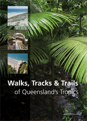
Walks, Tracks and Trails of Queensland's Tropics
By: Derrick Stone
More than 150 of the best walks, tracks and trails in Queensland's Tropics, covering the best the state has to offer.
Queensland’s tropics provide numerous environments for enjoyable walking: lush rainforests, cloud-shrouded mountains, extinct volcanoes, savanna woodlands, and magnificent beaches on the coast and Great Barrier Reef islands. + Full description
This book brings together more than 150 of the best walks, tracks or trails in Queensland’s tropics, located within the coastal strip between Rockhampton and Cooktown. Walks vary from short boardwalk strolls in the lowland rainforests of Daintree National Park to 4-6 day hiking and camping trips on Hinchinbrook Island. Other routes follow old gold miners’ and forestry tracks or coaching routes or feature historical sites, rivers, lagoons, geological and geographical formations or much earlier Aboriginal communication tracks where Dreamtime stories add a further dimension. Man-made environments of abandoned gold towns, heritage riverfronts, Art Deco streetscapes and Second World War installations also feature. Most routes are best completed during the ‘Dry’ season (May to October) and walked by moderately fit individuals. Most do not require specialist navigation or bushcraft skills.
Walks, Tracks and Trails of Queensland’s Tropics highlights the best the region has to offer. Easy-to-interpret maps are included to help you navigate, and the book’s size makes it convenient to carry in the backpack.
- Short descriptionNews
Also available from the same author: Walks, Tracks and Trails of Victoria and Walks, Tracks and Trails of New South Wales.
Details
Paperback | March 2016 | $ 39.95ISBN: 9781486303076 | 288 pages | 240 x 172 mm
Publisher: CSIRO Publishing
Colour photographs, Maps
ePDF | March 2016
ISBN: 9781486303083
Publisher: CSIRO Publishing
Available from eRetailers
ePUB | March 2016
ISBN: 9781486303090
Publisher: CSIRO Publishing
Available from eRetailers
Features
- Highlights of a particular walk are identified
- Easy to follow directions on location and duration of walk
- Maps are simple, easy to interrupt and provide basic accurate information
- All walks/trails which require maps have them
- Most of the routes chosen are relatively well-defined and do not require specialist navigation or bushcraft skills
- Up to date photography illustrates part of the environment and concentrates on features that identify a particular walk from another
- Historical or geological information that adds to the walk/trail experience
- Easy to handle size in the field
- Specialist equipment is not required for most of the walks
Contents
AcknowledgementsIntroduction
Rockhampton - Yeppoon
Mackay - Cape Hillsborough
Whitsundays
Bowen
Townsville
Ingham - Cardwell
Tully - Mission Beach
Innisfail - Cairns
Atherton - Herberton
Cairns
Mossman - Cape Tribulation
Bloomfield River - Cooktown


