

A remotely sensed weight gain model for sheep in the semi-arid Karoo shrublands of South Africa
Christiaan J. Harmse A B * and Adriaan van Niekerk B
A Northern Cape Department of Agriculture, Environmental Affairs, Land Reform and Rural Development, Eiland Research Station, Upington, South Africa.
B Department of Geography & Environmental Studies, Stellenbosch University, Stellenbosch, South Africa.
The Rangeland Journal 45(1) 1-11 https://doi.org/10.1071/RJ22049
Submitted: 19 August 2022 Accepted: 11 March 2023 Published: 3 April 2023
© 2023 The Author(s) (or their employer(s)). Published by CSIRO Publishing on behalf of the Australian Rangeland Society. This is an open access article distributed under the Creative Commons Attribution-NonCommercial-NoDerivatives 4.0 International License (CC BY-NC-ND)
Abstract
The monitoring of animal weight gain is expensive as it often involves the rounding up of animals over large areas and long distances. Such monitoring is an arduous process that causes stress related health problems and weight loss in animals. The aim of this study was to evaluate the use of remotely sensed vegetation indices for modelling sheep weight gain in semi-arid rangelands. The temporal and spatial patterns of grazing were investigated using Sentinel-2 imagery, collar data obtained from a global position system (GPS), and data of sheep weight related to grazing hotspots. Historical animal weight data were compared statistically with nine commonly used spectral indices extracted from Sentinel-2 imagery to determine how vegetation conditions relate to sheep weight gain. Sheep appeared to adapt their grazing behaviour according to time of the year, with the average distance walked per sheep per day in line with previous studies. In contrast to distance walked, sheep at lower stocking densities used less grazing area than at higher densities. The normalised difference vegetation index (NDVI) proved to best model liveweight changes. By combining remote sensing (RS) and GPS data, our understanding of sheep grazing patterns and sheep weight gain was improved. This can lead to the optimisation of production potential through precision farming. The finding has applications for studies conducted on non-reproductive sheep in semi-arid Karoo rangeland systems of South Africa. Because the model is both cost-effective and replicable, it offers a long-term monitoring template for livestock studies elsewhere.
Keywords: grazing management, livestock weight gain, normalised difference vegetation index, precision farming, rangelands, semi-arid, Sentinel 2, shrublands.
Introduction
To meet the expected 43% growth in the world’s population, global meat production must increase by 73% by 2050 (Myers and Bernstein 2011). The South African livestock industry encompasses more than 45 million cattle, sheep, and goats (Meissner et al. 2014). The economic pressures on South African farmers brought on by the Covid-19 pandemic and recent droughts have resulted in livestock being retained for longer before sale. This has increased grazing pressure, exacerbated by livestock’s tendency to frequent areas with the most palatable plant species within grazing camps (Harmse et al. 2022). The sustainability of extended grazing periods and the selective grazing behaviour when animals are retained for longer periods for unforeseen reasons are little researched topics.
Monitoring livestock weight is crucial in arid to semi-arid rangelands for assessing animal health (Brown et al. 2015), and determining optimal breeding times, given that low weight gain can significantly reduce the livestock productivity (Kenyon et al. 2004; Ferguson et al. 2011; Saul et al. 2011). Sudden weight loss in animals can also indicate severe disease, health condition or dehydration (Chedid et al. 2014). Body weight data are therefore a useful indicator of when to increase or reduce additional feed (Brown et al. 2015). Increases or decreases in animal weight indicates the state (quantity and quality) of available forage (Mahgoub et al. 2000).
Regular livestock weighing helps reduce the impact of livestock price volatility on farming businesses by maximising output and reducing input costs and wastage because producers can achieve price premiums by meeting the livestock buyers’ specifications. Monitoring animal weight gain is costly and is stressful to animals, so farmers often rely on visual estimates (Jones et al. 2011; Grandin 2014). But visual estimates are prone to inaccuracy, with some methods having been reported to underestimate actual animal weight by around 18% (Besier and Hopkins 1988; van Dijk et al. 2015). Moreover, in extensive rangelands, the spatial scale, inaccessibility, and lack of necessary specialised skills and knowledge result in farmers not conducting regular visual estimates.
Alternative animal and weight gain monitoring methods include proximal sensors such as walk-over weighing (Filby and Turner 1975; González-García et al. 2018). However, such instruments are expensive to acquire and maintain, particularly for extensive rangelands. A viable alternative to animal weighing, visual estimates and proximal sensors is to monitor the vegetation condition (Browning et al. 2018). Improved vegetation condition can contribute to healthier animals and increased weight gain.
Satellite imagery is efficient for monitoring vegetation condition (Lawley et al. 2016; Rokni and Musa 2019), especially imagery having high spatial and temporal resolutions, and aids the calculation of vegetation indices correlated with rangeland condition (Brandt et al. 2015). Comparisons of vegetation indices with animal weight gain data can support decisions about when to rotate sheep to new grazing camps or when to provide supplementary feed (Browning et al. 2018; Pearson et al. 2021). However, keeping track of where animals are grazing is essential to the monitoring of rangeland condition as it indicates animals’ preferred grazing areas that may need protection from trampling and overgrazing.
This paper reports on a study aimed to evaluate the use of remotely sensed vegetation and moisture indices for modelling sheep weight gain in semi-arid rangelands. Historical animal weight data were statistically compared to nine commonly used vegetation indices extracted from Sentinel-2 imagery to determine how vegetation condition related to sheep weight gain.
Materials and methods
Study area
The study was conducted at the Carnarvon Agricultural Research Station (Fig. 1), approximately 25 km west of Carnarvon in the Northern Cape province of South Africa (31.0086°S, 21.8939°E). The research station is located within the Nama-Karoo Biome (>400 000 km2) (Mucina et al. 2006).

|
The vegetation consists primarily of dwarf shrubs such as Pentzia spp., Eriocephalus spp. and Ruschia intricata, and grass species such as Aristida spp., Enneapogon spp. and Stipagrostis spp. The soils are very shallow, with the A horizon ranging between 10 and 500 mm deep and consist mainly of Glenrosa and Mispa forms.
Mean annual precipitation (1927–2019) is 201 mm, with most rain occurring during late summer and early autumn. March is the wettest month. Temperatures range from 39.9°C (maximum) in summer to −7.5°C (minimum) in winter. The primary land use is small stock farming (Hoffman et al. 2018).
The long-term grazing trial
This study forms part of a stocking density grazing trial on 360 ha established in 1988 by the Department of Agriculture to assess the effects of four stocking densities on vegetation condition. The stocking densities were set at rates representing ‘high’ (4.0 ha per small livestock unit (ha SSU−1)), ‘recommended’ (5.5 ha SSU−1), ‘low’ (7.0 ha SSU−1) and ‘very low’ (8.0 ha SSU−1) stocking densities (Harmse and Gerber 2018). Each herd in the trial consists of 12 Afrino ewes per stocking density treatment and the camps differ in size. For example, the three largest camps (32 ha each) have a low stocking density of 8 ha SSU−1 and the three smallest camps (16 ha each) have the highest stocking density of 4 ha SSU−1. The animals are alternated every 12 weeks in a three-camp rotational grazing management system. Each camp is considered a replication, thus three replications per stocking density. A camp is similar to the term ‘paddock,’ which is used to describe a fenced-in area used for grazing. Additional information on the grazing trial is available from Harmse and Gerber (2018).
Data collection and preparation
Satellite data
The Copernicus Open Access Hub was used to acquire Sentinel-2 (S2) imagery (Copernicus 2 2022). The twin S2 Earth observation satellites captured 13-band multispectral images of the study site at a 5-day interval. The data set contained 26 cloud-free surface reflectance images representing each month from November 2017 to December 2019. The images were used to generate nine vegetation condition and soil moisture indices by using spectral bands 2, 3, 4 and 8 (10-m spatial resolution), 9 (60-m spatial resolution) and 11 (20-m spatial resolution). Nine spectral indices were calculated, namely the atmospherically resistant vegetation index (ARVI) (Kaufman and Tanre 1992); bare soil index (BSI) (Rikimaru and Miyatake 1997; Diek et al. 2017); colour infrared (CIR) (Sripada et al. 2006; Ihse 2007); green chlorophyll index (GCI) (Gitelson et al. 2005); green normalised difference vegetation index (GNDVI) (Gitelson et al. 1996); modified soil adjusted vegetation index 2 (MSAVI2) (Qi et al. 1994); moisture stress index (MSI) (Meng et al. 2016); normalised difference moisture index (NDMI) (Gao 1996); and the normalised difference vegetation index (NDVI) (Tucker 1979).
Sheep movement data (GPS tracking collars)
Three GPS/GSM collars (supplied by African Wildlife Tracking) were fitted to randomly selected sheep from each herd. In total, 12 GPS collars were fitted across all four stocking density treatments. The collared sheep were released into the grazing camps and 1 month was allowed for customisation to the GPS collars. Because the Afrino breed is a herd animal, the movements of the collared sheep represent the movements of the herds. The GPS collars were fitted at the beginning of each season (November), after which the sheep were free to graze undisturbed for the rest of the season (they were only handled briefly once every 2 weeks when the sheep were weighed). The collars recorded the GPS positions every hour over the study period (November 2017 to December 2019). Each record comprised the observation’s date, time and coordinate (location) with a geo-position error of 10 m.
Sheep weight data
All 48 sheep were weighed at the start of each season and subsequently every 14 days. Weight gain or loss was determined per season per year. Animal weight was recorded both at the start and end of each 12-week grazing period, and used to determine individual animal weight gain or loss and average weight gain or loss per herd (12 sheep). Weight measurements were taken across each grazing period (summer, autumn, winter, spring), resulting in 44 individual weight measurements from the end of 2017 to the end of 2019, resulting in 2112 weight measurements in total. No supplementary feed was given.
Mapping of grazing hot spots
Preferred grazing areas, or hotspots, were identified using GPS point densities and hot spot analysis. The Getis-Ord Gi* statistic, as implemented in the Optimised Hot Spot Analysis tool of ArcGIS 10.7 (ESRI 2017), was used to identify statistically significant spatial clustering in the GPS data. A significant hot spot is indicated by a feature’s high Getis-Ord Gi* z-score and low P-value. A significant coldspot exists when the P-value is low and the negative z-score is low. There is no spatial clustering if the z-score is close to 0. The camp boundaries were used to define the bounding polygon. Additional information on determining preferred grazing areas is available in Harmse et al. (2022).
Data analysis
Statistical comparison of hot spots and grazing times
One-way analysis of variance (ANOVA) and Tukey’s pairwise post hoc test (TPPHT), as implemented in PAST ver. 4.03 (Hammer et al. 2001), were used to determine whether there are a significant seasonal (summer and winter) differences in daily temporal usage of hot spot grazing areas.
Distance walked and total grazing area used
Daily distances walked by sheep were determined and comparisons were made of the mean distance walked by sheep under different stocking density treatments. In addition, the ratio between the distance walked and the available grazing area was calculated by dividing the daily average distance walked by the size of the grazing area available for each specific stocking density. By applying ANOVA and TPPHT the significant differences in the distance walked per day determined and the grazing areas used for different stocking densities were calculated.
Statistical comparisons of animal weight gain and spectral indices
Individual sheep weight gains or losses were calculated per season over two years. The average sheep weight gain of the herd per camp (i.e. stocking density) per season was correlated with the average spectral index value derived from the S2 imagery over the same period. Index values were subjected to logarithmic, reciprocal, square, and square root transformations to find the best approximation to the normal distribution. Data normality was tested using quantile plots. Linear and quadratic regressions were used to compare average sheep weight gain to the average spectral index values per camp.
The best correlation was determined with linear and quadratic regression analysis fitted to the average spectral index scores. The magnitude of the trends for each vegetation, moisture and soil index was calculated to determine the highest correlation between animal weight gain and different spectral index scores.
Results
Grazing hotspots
Harmse et al. (2022) found that grazing camps A1, B2, B3, B4, C2 and C4 (see Fig. 2) featured grazing hot spots (areas where sheep tend to cluster) along drainage lines. Sheep spent significantly more time in the hot spots although they represent a relatively small portion (average 3.4 ha) of the total available grazing land (average 25.9 ha). In contrast to this clustering, no flocking of sheep occurred when they were allocated to grazing camps with no drainage lines (A2, A3, A4, B1, C1 and C3 in Fig. 2). The identified hot spots (and cold spots) correlated highly (R2 = 0.82) with NDVI (Harmse et al. 2022).

|
Grazing times
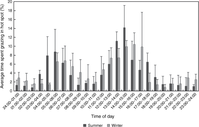
During summer the sheep spent an average of 48.9% of their time in hot spots. According to Fig. 3, the sheep tended to move into the hot spot grazing areas from 03:00 with a large proportion (28.6%) of time spent in hot spots between 03:00 and 07:00, peaking at about 05:00. Sometime around 08:00 the sheep moved to water points, returning to hot spots between 12:00 and 18:00. Most (14%) hot spot grazing occurred between 14:00 and 15:00. Significantly more time was spent in hot spots between 13:00 and 15:00 than any other time.
|
Grazing patterns were different in winter (Fig. 3) when sheep moved into grazing areas later (from 05:00). On average the sheep spent 22.9% of their time in grazing hot spots between 05:00 and 08:00. The sheep spent less time outside the hot spots (e.g. at watering holes) in winter mornings compared with their behaviour in summer. Most (26.8%) of the time spent in hot spots occurred from 11:00 to 17:00, peaking between 15:00 and 16:00. Significantly, in winter more time was spent in hot spots between 14:00 and 17:00 compared with other times.
Grazing area utilised under different stocking densities
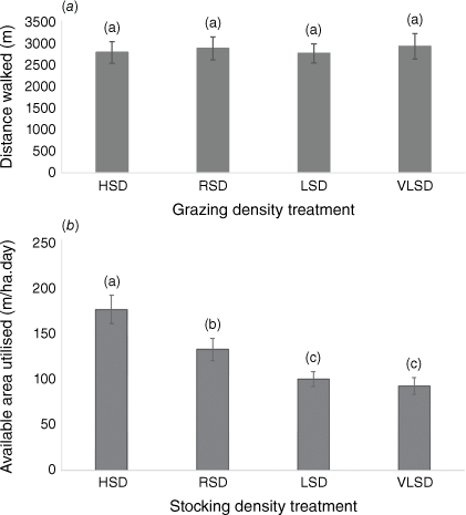
Sheep walked an average of 2600–3000 m per day (Fig. 4a). No significant differences were found in the distances walked by sheep under different stocking densities. In contrast, the grazing area used by sheep under the different stocking densities varied significantly (Fig. 4b). The sheep in the LSD (light) group used less grazing area compared with the RSD (recommended) and HSD (high stocking density) groups (Fig. 4b).
|
Animal weight gain versus spectral indices
Nine spectral indices were statistically compared to average animal weight gain. Two indices, the bare soil index (BSI) and the green normalised difference vegetation index (GNDVI), were best described by linear models based on the Akaike information criterion (Akaike 1974), whereas the atmospherically resistant vegetation index (ARVI), colour infrared (CIR), green coverage index (GCI), modified soil adjusted vegetation index 2 (MSAVI2), moisture stress index (MSI), normalised difference moisture index (NDMI) and the normalised difference vegetation index (NDVI) were best described using quadratic models. Strong (R2 > 0.72) models were achieved for MSAVI2 and NDVI, the latter producing the strongest (R2 = 0.77) model (Table 1).

|
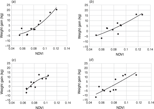
The residual standard deviation of weight gain was 3.6 kg. The regression equation for the untransformed data was: Ó¯ = 930.41x2 + 188.72x − 18.766, where Ó¯ is the estimated weight gain (kg) and x is the mean NDVI value. The mean calculated weight gain was 3.1 kg (±3.7 s.e.) at an average NDVI of 0.08 (±0.009 s.e.). The minimum and maximum NDVI values (0.009 and 0.127, respectively), and the recorded sheep weight gain or loss (20.3 and −11.8 kg, respectively) reflect the broad range and variability in terms of average seasonal NDVI values and animal weight gain. Fig. 5 depicts the best performing regression model.

|
Because NDVI was the most successful index for modelling sheep weight gain (Table 1), the magnitude of the model’s trend was determined for each stocking density (Table 2). A quadratic regression model best described the trends based on the Akaike information criterion (Akaike 1974) for all densities. A statistically significant increase in weight gain with increasing NDVI was found for all stocking densities (Table 2, Fig. 5). The strongest model was produced for the very light stocking density (VLSD) class. The mean calculated weight gain for the VLSD class was 4.2 kg (±3.3 s.e.), as NDVI increased by 0.082 (±0.008 s.e.). The weakest (R2 = 0.691) NDVI-based weight gain model was produced for the HSD class, with a mean weight gain of 1.0 kg (±5.0 s.e.) as NDVI increased by 0.078 (±0.011 s.e.). Generally, a higher mean weight gain was noted for the VLSD cases compared with the HSD cases, while the increase in mean NDVI remained relatively stable (Fig. 6).

|
|
Discussion
Temporal grazing behaviour
Sheep congregate around watering points at a certain time of the day. Harmse et al. (2022) found that these sheep later move to preferred patches of pasture (grazing hot spots) away from the watering points. The sheep in this study tended to graze mostly in the late afternoon and for a few hours in the morning. The animals were absent from grazing hot spots for most of the late morning and early afternoon. It is assumed this time was spent around the watering points to rest, drink and ruminate (Dwyer 2009). The temporal patterns were, however, characteristically seasonal. During winter months, morning grazing started and ended two hours later than in summer, whereas afternoon grazing excursions started and ended earlier in winter. For example, summer grazing ended around 17:00, while in winter grazing ended around 19:00. These results suggest that sheep adapt their grazing behaviour to compensate for the lower winter temperatures common in the Karoo and a later winter sunrise. Sheep appeared to wait for first light during winter before moving into the grazing areas. Shorter grazing time during the winter months means that the animals have to increase their rate of food intake. This agrees with Iason et al. (1999) who observed that daily foraging times affect instantaneous intake rates.
In this study, animals started moving into hot spot areas as early as 03:00 in summer, suggesting they preferred the lower morning temperatures to graze before returning to the watering points where they spent longer in the late morning and early afternoon to hydrate before returning to grazing areas in the late afternoon when the temperatures started to drop. Farmers opting to kraal (i.e. keep animals in overnight holding pens) their animals for protection against stock theft and predators consequently forfeit valuable grazing time and alter typical sheep grazing behaviour in summer.
Sheep adapted their grazing behaviour according to the season. This has significant implications for rangeland management, particularly in relation to extensive rangelands such as those in South Africa and Australia, where animals are often herded over long distances into holding pens (krale). Management of sheep grazing patterns (e.g. when they would likely be close to watering points or in grazing hot spots) could reduce animal stress and vegetation damage caused by trampling and vehicles.
Grazing area utilised under different stocking densities
The average distance walked per sheep per day accorded with the distances recorded in previous studies, i.e. about 3 km (Roux 1992; Brand 2000). When assuming less competition for forage among sheep at lower stocking densities (i.e. they would reach a level of fulfillment sooner and return to the watering point), one expects sheep occupying higher stocking densities to walk longer distances per day compared to those at lower densities. But it transpired that distances walked did not significantly differ between the various stocking densities. A plausible explanation is that sheep have a survival instinct to cover a certain distance per day in search of fodder. The distance sheep walk has adverse consequences for animal productivity, and increases their energy requirements (Maurya et al. 2012). Walking longer distances in search of fodder results in reduced weight gain and milk production while negatively influencing reproductive performance due to substantial amounts of energy being used to combat walking stress (Henning 1987; Matthewman et al. 1993). In contrast to the findings about distance walked, significant differences became evident in the use of grazing area between the various stocking density classes. Lower stocking densities revealed the use of less available grazing land compared to use at higher stocking densities. Sheep grazing at lower stocking densities experience less competition from other sheep in finding fodder and meeting nutritional requirements. This likely reduces the need for the sheep to travel longer distances in these camps and utilise the larger available areas in search of forage (Winder et al. 1996; Browning et al. 2018).
Statistical comparisons between animal weight gain and spectral indices
Average NDVI correlated best with sheep weight gain, outperforming the other eight indices (ARVI, BSI, CIR, GCI, GNDVI, MSI, NDMI, MSAVI2). The NDVI makes use of the red and near infrared light reflectance of vegetation. Chlorophyll absorbs most of the red light, while leaves’ internal structure reflects most near infrared light (Nemani and Running 1989). A possible explanation for NDVI’s top performance is that it is a good indicator of the presence of vegetation with higher nitrogen content and digestibility (Insua et al. 2019; White et al. 2019). In such circumstances, weight gain in sheep in camps with a high NDVI value would be higher through consuming the better quakity forage. NDVI is also useful for monitoring vegetation at continental or global scales, as to the index compensates for changing illumination conditions, surface slope and aspect (Olthof et al. 2008). In the semi-arid rangelands of the Karoo these criteria are highly variable across space and time.
The effectiveness of NDVI for estimating sheep weight in Karoo shrublands has several important implications. NDVI is relatively well understood by farmers and it is easily obtainable from a wide range of sources at high spatial and temporal resolutions. For instance, the S2 imagery used in this study is available at 5-day intervals and at 10-m spatial resolution. Consequently, sheep weight gain can be estimated per camp on an ongoing basis for determining if and when supplementary feed is necessary. Feed supplementation can start as soon as weight loss is detected (modelled) (González et al. 2018; Pearson et al. 2021). If supplementary feed cannot be provided, stocking densities can be reduced. NDVI-based weight gain modelling can inform livestock farmers when to remove animals from camps to ensure health-conscious consumers that standards for maximum fat levels are met. Under a rotational grazing management system, knowing when and where (depending on available forage) to move animals can significantly improve meat production and quality. Even the very large camps of the Karoo can be easily managed in this way. Also, remotely sensed weight monitoring can help livestock farmers in this harsh environment to make more informed and timely decisions (Handcock et al. 2009; Pearson et al. 2021).
This is the first study to show the relationships between vegetation indices and sheep weight gain in Karoo rangelands using remote sensing technologies. The methods used and tested in the semi-arid study environment can be applied across all Karoo rangelands and integrated with fine-scaled studies of resource selection to inform interpretations about livestock space use across spatial scales.
Limitations of the study
The NDVI-based weight gain models performed very well (R2 from 0.72 to 0.91) for low to medium stocking densities, but less so for high stocking densities. This is most likely due to rangelands being over utilised or degraded under high stocking densities. On farms that are not managed sustainably, the NDVI-based model may not provide accurate estimates of weight gain.
Daily temperatures and their impacts on time spent grazing were not assessed. The rainfall-based weight gain model performed relatively well (R2 of 0.81) for high stocking densities. More work is needed to investigate whether a combination of the two approaches (i.e. NDVI and rainfall) would offer a more robust solution.
The role of herd size on time spent grazing was not assessed. Previous studies have found that sheep in smaller groups spent less time grazing than sheep in larger groups (Penning et al. 1993). The finding of this study that lower stocking densities utilise smaller grazing areas supports these earlier findings. A main limitation of this study is that the animals studied were not reproductive. The weight gain of reproductive sheep and the additional load on the vegetation during the lambing season could lead to different results. A similar study focussing on reproductive sheep is recommended.
Conclusion
Combining RS and GPS data improved our understanding of sheep grazing patterns and sheep weight gain. This can lead to the optimisation of production potential through precision farming. GPS-based remote monitoring of sheep behaviour across rangelands can assist in managing flocks, as well as their impacts on the environment.
The model developed for the prediction of sheep weight gain is accurate and suitable for use in semi-arid rangelands of the Karoo. The stocking densities used by farmers were accounted for by sampling weight gain under varying degrees of grazing pressures. The regression equation is applicable to NDVI values derived from Sentinel-2 images to support livestock-related decisions in the Karoo rangelands. The novel weight gain model can assist farmers in their land management decisions and help prevent overgrazing by determining optimal stocking densities. Given that the model can be applied per pixel, it is useful for redesigning grazing camps to increase the production potential of these rangelands. If a camp shows the potential for additional weight gain, the farmer can decide to utilise the camp for a longer period, or allocate additional sheep to ensure the camp is utilised to its full potential.
The best prices for livestock are achieved when animals are bought by companies selling to health-conscious consumers (Wilson 2015; Hughes 2016). Therefore, these companies prefer qualifying free-ranging sheep and often reject sheep that are too fat. This weight gain model allows flock monitoring and provides near real-time information on the ideal time for removing the animals, thereby ensuring that the standards set by such companies are maintained.
Knowing the time of day sheep graze can help to optimise livestock production. Our findings suggest that animals fenced at night would lose valuable grazing time during the summer months, depending on the time the flock is fenced. Lighter stocking densities with less competition among sheep reduce both the need for sheep to travel long distances and the need for larger available areas to obtain forage to meet nutritional requirements.
The methods developed in this study provide a novel framework for understanding the space use and weight gain of sheep in the semi-arid Karoo and similar environments. As such, the framework should have broad applications for studies conducted in arid systems globally and owing to its cost-effectiveness and repeatability, it could provide a long-term monitoring template for livestock studies elsewhere.
Data availability
The corresponding author will provide the data on request.
Conflicts of interest
The authors declare no conflicts of interest.
Declaration of funding
This research did not receive any specific funding.
Author contributions
Conceptualisation, CJH and AvN; methodology, CJH; formal analysis, CJH; investigation, CJH; writing – original draft preparation and wrote main manuscript text, CJH; reviewing and editing, CJH and AvN; visualisation and prepared figures, CJH; supervision, AvN; project administration, CJH. All authors have read and agreed to the published version of the manuscript.
Acknowledgements
The authors thank the Northern Cape Department of Agriculture, Environmental Affairs, Land Reform and Rural Development for the maintenance and monitoring of this valuable long-term grazing trial. The care and management of the trial by the farm manager, Mr Tommie Buys, is gratefully recognised. The authors thank Helene van Niekerk (www.linguafix.net, accessed 12 July 2022) and Dr Pieter de Necker (11 December 2022) for language editing of this manuscript.
References
Akaike, H (1974). A new look at the statistical model identification. IEEE Transactions on Automatic Control 19, 716–723.| A new look at the statistical model identification.Crossref | GoogleScholarGoogle Scholar |
Besier, RB, and Hopkins, DL (1988). Anthelmintic dose selection by farmers. Australian Veterinary Journal 65, 193–194.
| Anthelmintic dose selection by farmers.Crossref | GoogleScholarGoogle Scholar |
Brand, TS (2000). Grazing behaviour and diet selection by Dorper sheep. Small Ruminant Research 36, 147–158.
| Grazing behaviour and diet selection by Dorper sheep.Crossref | GoogleScholarGoogle Scholar |
Brandt, M, Mbow, C, Diouf, AA, Verger, A, Samimi, C, and Fensholt, R (2015). Ground‐ and satellite‐based evidence of the biophysical mechanisms behind the greening Sahel. Global Change Biology 21, 1610–1620.
| Ground‐ and satellite‐based evidence of the biophysical mechanisms behind the greening Sahel.Crossref | GoogleScholarGoogle Scholar |
Brown, DJ, Savage, DB, Hinch, GN, and Hatcher, S (2015). Monitoring liveweight in sheep is a valuable management strategy: a review of available technologies. Animal Production Science 55, 427–436.
| Monitoring liveweight in sheep is a valuable management strategy: a review of available technologies.Crossref | GoogleScholarGoogle Scholar |
Browning, DM, Spiegal, S, Estell, RE, Cibils, AF, and Peinetti, RH (2018). Integrating space and time: a case for phenological context in grazing studies and management. Frontiers of Agricultural Science and Engineering 5, 44–56.
| Integrating space and time: a case for phenological context in grazing studies and management.Crossref | GoogleScholarGoogle Scholar |
Chedid, M, Jaber, LS, Giger-Reverdin, S, Duvaux-Ponter, C, and Hamadeh, SK (2014). Review: Water stress in sheep raised under arid conditions. Canadian Journal of Animal Science 94, 243–257.
| Review: Water stress in sheep raised under arid conditions.Crossref | GoogleScholarGoogle Scholar |
Copernicus 2 (2022) Copernicus Open Access Hub. European Commission. Available at https://scihub.copernicus.eu/ [accessed 1 May 2022]
Diek, S, Fornallaz, F, Schaepman, ME, and De Jong, R (2017). Barest pixel composite for agricultural areas using landsat time series. Remote Sensing 9, 1245.
| Barest pixel composite for agricultural areas using landsat time series.Crossref | GoogleScholarGoogle Scholar |
Dwyer C (2009) ‘The behaviour of sheep and goats. The ethology of domestic animals.’ 2nd edn: An introductory text. pp. 161–176. (CAB International: Oxfordshire, UK)
ESRI (2017) ‘ArcGIS desktop: release 10.5’. pp. 844–845. (Environmental Systems Research Institute: Redlands, CA, USA)
Ferguson, MB, Thompson, AN, Gordon, DJ, Hyder, MW, Kearney, GA, Oldham, CM, and Paganoni, BL (2011). The wool production and reproduction of Merino ewes can be predicted from changes in liveweight during pregnancy and lactation. Animal Production Science 51, 763–775.
| The wool production and reproduction of Merino ewes can be predicted from changes in liveweight during pregnancy and lactation.Crossref | GoogleScholarGoogle Scholar |
Filby, DE, and Turner, MJB (1975). Improvements in livestock weighing techniques. Agricultural Research Council Research Review 1, 90–96.
Gao, B-C (1996). NDWI—A normalized difference water index for remote sensing of vegetation liquid water from space. Remote Sensing of Environment 58, 257–266.
| NDWI—A normalized difference water index for remote sensing of vegetation liquid water from space.Crossref | GoogleScholarGoogle Scholar |
Gitelson, AA, Merzlyak, MN, and Lichtenthaler, HK (1996). Detection of red edge position and chlorophyll content by reflectance measurements near 700 nm. Journal of Plant Physiology 148, 501–508.
| Detection of red edge position and chlorophyll content by reflectance measurements near 700 nm.Crossref | GoogleScholarGoogle Scholar |
Gitelson, AA, Viña, A, Ciganda, V, Rundquist, DC, and Arkebauer, TJ (2005). Remote estimation of canopy chlorophyll content in crops. Geophysical Research Letters 32, L08403.
| Remote estimation of canopy chlorophyll content in crops.Crossref | GoogleScholarGoogle Scholar |
González, LA, Kyriazakis, I, and Tedeschi, LO (2018). Review: Precision nutrition of ruminants: approaches, challenges and potential gains. Animal 12, s246–s261.
| Review: Precision nutrition of ruminants: approaches, challenges and potential gains.Crossref | GoogleScholarGoogle Scholar |
González-García, E, Alhamada, M, Pradel, J, Douls, S, Parisot, S, Bocquier, F, Menassol, J-B, Llach, I, and González, LA (2018). A mobile and automated walk-over weighing system for a close and remote monitoring of liveweight in sheep. Computers and Electronics in Agriculture 153, 226–238.
| A mobile and automated walk-over weighing system for a close and remote monitoring of liveweight in sheep.Crossref | GoogleScholarGoogle Scholar |
Grandin T (2014) Behavioural principles of handling cattle and other grazing animals under extensive conditions. In ‘Livestock handling and transport’. 4th edn. (Ed. T Grandin) pp. 39–64. (CABI) https://books.google.co.za/books/about/Livestock_Handling_and_Transport_4th_Edi.html?id=O8eWBAAAQBAJ&redir_esc=y
Hammer, Ø, Harper, DAT, and Ryan, PD (2001). PAST: Paleontological statistics software package for education and data analysis. Palaeontologia Electronica 4, 9–10.
Handcock, RN, Swain, DL, Bishop-Hurley, GJ, Patison, KP, Wark, T, Valencia, P, Corke, P, and O’Neill, CJ (2009). Monitoring animal behaviour and environmental interactions using wireless sensor networks, GPS collars and satellite remote sensing. Sensors 9, 3586–3603.
| Monitoring animal behaviour and environmental interactions using wireless sensor networks, GPS collars and satellite remote sensing.Crossref | GoogleScholarGoogle Scholar |
Harmse, CJ, and Gerber, HJ (2018). Effect of stocking density on vegetation and animal performance within the semi-arid shrublands of the Karoo, South Africa. African Journal of Range & Forage Science 35, 13–22.
| Effect of stocking density on vegetation and animal performance within the semi-arid shrublands of the Karoo, South Africa.Crossref | GoogleScholarGoogle Scholar |
Harmse, CJ, Gerber, H, and Van Niekerk, A (2022). Evaluating several vegetation indices derived from Sentinel-2 imagery for quantifying localized overgrazing in a semi-arid region of South Africa. Remote Sensing 14, 1720.
| Evaluating several vegetation indices derived from Sentinel-2 imagery for quantifying localized overgrazing in a semi-arid region of South Africa.Crossref | GoogleScholarGoogle Scholar |
Henning, PH (1987). The effect of increased energy demand through walking exercise on intake and ruminal characteristics of sheep fed a roughage diet. The Journal of Agricultural Science 109, 53–59.
| The effect of increased energy demand through walking exercise on intake and ruminal characteristics of sheep fed a roughage diet.Crossref | GoogleScholarGoogle Scholar |
Hoffman, TM, Skowno, A, Bell, W, and Mashele, S (2018). Long-term changes in land use, land cover and vegetation in the Karoo drylands of South Africa: implications for degradation monitoring. African Journal of Range & Forage Science 35, 209–221.
| Long-term changes in land use, land cover and vegetation in the Karoo drylands of South Africa: implications for degradation monitoring.Crossref | GoogleScholarGoogle Scholar |
Hughes SJ (2016) Loyalty vs deception: the truth behind ‘organic’ and ‘free-range’ brand labels. Doctoral Dissertation, The IIE, Vega School of Brand Leadership in Cape Town, South Africa. https://iiespace.iie.ac.za/bitstream/handle/11622/101/Sarah‐Jane%20Hughes.pdf?sequence=1
Iason, GR, Mantecon, AR, Sim, DA, Gonzalez, J, Foreman, E, Bermudez, FF, and Elston, DA (1999). Can grazing sheep compensate for a daily foraging time constraint? Journal of Animal Ecology 68, 87–93.
| Can grazing sheep compensate for a daily foraging time constraint?Crossref | GoogleScholarGoogle Scholar |
Ihse, M (2007). Colour infrared aerial photography as a tool for vegetation mapping and change detection in environmental studies of Nordic ecosystems: a review. Norsk Geografisk Tidsskrift-Norwegian Journal of Geography 61, 170–191.
| Colour infrared aerial photography as a tool for vegetation mapping and change detection in environmental studies of Nordic ecosystems: a review.Crossref | GoogleScholarGoogle Scholar |
Insua, JR, Utsumi, SA, and Basso, B (2019). Estimation of spatial and temporal variability of pasture growth and digestibility in grazing rotations coupling unmanned aerial vehicle (UAV) with crop simulation models. PLoS One 14, e0212773.
| Estimation of spatial and temporal variability of pasture growth and digestibility in grazing rotations coupling unmanned aerial vehicle (UAV) with crop simulation models.Crossref | GoogleScholarGoogle Scholar |
Jones, A, Van Burgel, AJ, Behrendt, R, Curnow, M, Gordon, DJ, Oldham, CM, Rose, IJ, and Thompson, AN (2011). Evaluation of the impact of lifetime wool on sheep producers. Animal Production Science 51, 857–865.
| Evaluation of the impact of lifetime wool on sheep producers.Crossref | GoogleScholarGoogle Scholar |
Kaufman, YJ, and Tanre, D (1992). Atmospherically resistant vegetation index (ARVI) for EOS-MODIS. IEEE transactions on Geoscience and Remote Sensing 30, 261–270.
| Atmospherically resistant vegetation index (ARVI) for EOS-MODIS.Crossref | GoogleScholarGoogle Scholar |
Kenyon, PR, Morel, PCH, and Morris, ST (2004). The effect of individual liveweight and condition scores of ewes at mating on reproductive and scanning performance. New Zealand Veterinary Journal 52, 230–235.
| The effect of individual liveweight and condition scores of ewes at mating on reproductive and scanning performance.Crossref | GoogleScholarGoogle Scholar |
Lawley, V, Lewis, M, Clarke, K, and Ostendorf, B (2016). Site-based and remote sensing methods for monitoring indicators of vegetation condition: an Australian review. Ecological Indicators 60, 1273–1283.
| Site-based and remote sensing methods for monitoring indicators of vegetation condition: an Australian review.Crossref | GoogleScholarGoogle Scholar |
Mahgoub, O, Lu, CD, and Early, RJ (2000). Effects of dietary energy density on feed intake, body weight gain and carcass chemical composition of Omani growing lambs. Small Ruminant Research 37, 35–42.
| Effects of dietary energy density on feed intake, body weight gain and carcass chemical composition of Omani growing lambs.Crossref | GoogleScholarGoogle Scholar |
Matthewman, RW, Oldham, JD, and Horgan, GW (1993). A note on the effect of sustained exercise on straw intake and body weight in lactating cattle. Animal Science 57, 491–494.
| A note on the effect of sustained exercise on straw intake and body weight in lactating cattle.Crossref | GoogleScholarGoogle Scholar |
Maurya VP, Sejian V, Kumar K, Singh G, Naqvi SMK (2012) Walking stress influence on livestock production. In ‘Environmental stress and amelioration in livestock production’. (Eds V Sejian, S Naqvi, T Ezeji, J Lakritz, R Lal) pp. 75–95. (Springer: Berlin, Heidelberg)
Meissner, H, Scholtz, M, and Palmer, A (2014). Sustainability of the South African livestock sector towards 2050 Part 1: Worth and impact of the sector. South African Journal of Animal Science 43, 282–297.
| Sustainability of the South African livestock sector towards 2050 Part 1: Worth and impact of the sector.Crossref | GoogleScholarGoogle Scholar |
Meng, Q, Xie, Q, Wang, C, Ma, J, Sun, Y, and Zhang, L (2016). A fusion approach of the improved Dubois model and best canopy water retrieval models to retrieve soil moisture through all maize growth stages from Radarsat-2 and Landsat-8 data. Environmental Earth Sciences 75, 1377.
| A fusion approach of the improved Dubois model and best canopy water retrieval models to retrieve soil moisture through all maize growth stages from Radarsat-2 and Landsat-8 data.Crossref | GoogleScholarGoogle Scholar |
Mucina, L, Rutherford, MC, Palmer, AR, Milton, SJ, Scott, L, Lloyd, JW, Van der Merwe, B, Hoare, DB, Bezuidenhout, H, and Vlok, JHJ (2006). Nama-karoo biome. The vegetation of South Africa, Lesotho and Swaziland. Strelitzia 19, 324–347.
Myers, SS, and Bernstein, A (2011). The coming health crisis: indirect health effects of global climate change. F1000 Biology Reports 3, 3.
| The coming health crisis: indirect health effects of global climate change.Crossref | GoogleScholarGoogle Scholar |
Nemani, RR, and Running, SW (1989). Estimation of regional surface resistance to evapotranspiration from NDVI and thermal-IR AVHRR data. Journal of Applied Meteorology and Climatology 28, 276–284.
| Estimation of regional surface resistance to evapotranspiration from NDVI and thermal-IR AVHRR data.Crossref | GoogleScholarGoogle Scholar |
Olthof, I, Pouliot, D, Latifovic, R, and Chen, W (2008). Recent (1986–2006) Vegetation-specific NDVI trends in Northern Canada from satellite data. Arctic 61, 381–394.
Pearson, C, Filippi, P, and González, LA (2021). The relationship between satellite-derived vegetation indices and live weight changes of beef cattle in extensive grazing conditions. Remote Sensing 13, 4132.
| The relationship between satellite-derived vegetation indices and live weight changes of beef cattle in extensive grazing conditions.Crossref | GoogleScholarGoogle Scholar |
Penning, PD, Parsons, AJ, Newman, JA, Orr, RJ, and Harvey, A (1993). The effects of group size on grazing time in sheep. Applied Animal Behaviour Science 37, 101–109.
| The effects of group size on grazing time in sheep.Crossref | GoogleScholarGoogle Scholar |
Qi, J, Chehbouni, A, Huete, AR, Kerr, YH, and Sorooshian, S (1994). A modified soil adjusted vegetation index. Remote Sensing of Environment 48, 119–126.
| A modified soil adjusted vegetation index.Crossref | GoogleScholarGoogle Scholar |
Rikimaru A, Miyatake S (1997) Development of forest canopy density mapping and monitoring model using indices of vegetation, bare soil and shadow. In ‘Paper presented at the 18th ACRS’, Kuala Lumpur, Malaysia.
Rokni, K, and Musa, TA (2019). Normalized difference vegetation change index: a technique for detecting vegetation changes using Landsat imagery. CATENA 178, 59–63.
| Normalized difference vegetation change index: a technique for detecting vegetation changes using Landsat imagery.Crossref | GoogleScholarGoogle Scholar |
Roux FA (1992) The influence of the composition of mixed Karoo vegetation on the grazing habits of Merino and Dorper wethers. PhD Dissertation, Rhodes University, Grahamstown, South Africa.
Saul, G, Kearney, G, and Borg, D (2011). Pasture systems to improve productivity of sheep in south-western Victoria 2. Animal production from ewes and lambs. Animal Production Science 51, 982–989.
| Pasture systems to improve productivity of sheep in south-western Victoria 2. Animal production from ewes and lambs.Crossref | GoogleScholarGoogle Scholar |
Sripada, RP, Heiniger, RW, White, JG, and Meijer, AD (2006). Aerial color infrared photography for determining early in‐season nitrogen requirements in corn. Agronomy Journal 98, 968–977.
| Aerial color infrared photography for determining early in‐season nitrogen requirements in corn.Crossref | GoogleScholarGoogle Scholar |
Tucker, CJ (1979). Red and photographic infrared linear combinations for monitoring vegetation. Remote Sensing of Environment 8, 127–150.
| Red and photographic infrared linear combinations for monitoring vegetation.Crossref | GoogleScholarGoogle Scholar |
van Dijk, J, Eagle, SJ, Gillespie, AV, Smith, RF, Holman, AN, and Williams, HJ (2015). Visual weight estimation and the risk of underdosing dairy cattle. Veterinary Record 177, 75.
| Visual weight estimation and the risk of underdosing dairy cattle.Crossref | GoogleScholarGoogle Scholar |
White, CM, Bradley, B, Finney, DM, and Kaye, JP (2019). Predicting cover crop nitrogen content with a handheld normalized difference vegetation index meter. Agricultural & Environmental Letters 4, 190031.
| Predicting cover crop nitrogen content with a handheld normalized difference vegetation index meter.Crossref | GoogleScholarGoogle Scholar |
Wilson S (2015) An exploratory study of consumer behaviour with the view to determine the effectiveness of the red meat classification system. MBA Thesis, University of Stellenbosch Business School, Stellenbosch, South Africa.
Winder, JA, Walker, DA, and Bailey, CC (1996). Effect of breed on botanical composition of cattle diets on Chihuahuan desert range. Journal of Range Management 49, 209–214.
| Effect of breed on botanical composition of cattle diets on Chihuahuan desert range.Crossref | GoogleScholarGoogle Scholar |