

An archaeological example of Aboriginal management of a hydro-ecological system in the Murray River valley, South Australia
Craig Westell A * , Amy Roberts A , Daniel McCullough B and the River Murray and Mallee Aboriginal Corporation C
A College of Humanities, Arts and Social Sciences, Flinders University, Adelaide, SA, Australia.
B Department for Environment and Water, Water Science and Monitoring Branch, Water and River Murray Division, Adelaide, SA, Australia.
C River Murray and Mallee Aboriginal Corporation RNTBC, Adelaide, SA, Australia.
Marine and Freshwater Research 74(12) 1026-1038 https://doi.org/10.1071/MF23049
Submitted: 3 April 2023 Accepted: 13 June 2023 Published: 10 July 2023
© 2023 The Author(s) (or their employer(s)). Published by CSIRO Publishing. This is an open access article distributed under the Creative Commons Attribution-NonCommercial-NoDerivatives 4.0 International License (CC BY-NC-ND)
Abstract
Context: A rare archaeological example of Aboriginal water management in a Murray River floodplain upstream of Renmark is described and contextualised.
Aims: Historical accounts, archaeological descriptions and hydrological modelling are used to propose a likely function of the site.
Methods: The site was documented through archaeological field recording, a digital elevation model (DEM) developed through a real-time kinematic (RTK) survey and flood inundation modelling (FIM), and is interpreted through a review of archival and documentary sources.
Key results: The site represents one of only a few extant physical examples of Aboriginal water management in the Riverland and greater Murray–Darling Basin.
Conclusions: Our assessment indicates that Aboriginal people had excavated an artifical channel within the Calperum floodplain in order to manipulate natural water connectivity, most likely as part of a fish trap or weir structure.
Implications: The site builds an appreciation of the complexity of Aboriginal land practices and supports the impression gained though historical accounts of a curated and managed riverscape.
Keywords: Aboriginal archaeology, fish trap, flood inundation modelling, floodplain management, freshwater fishery, hydro-ecology, Murray–Darling Basin, Murray River.
Introduction
Australian Aboriginal peoples are known to have manipulated hydro-ecological systems in support of diverse lifeways. This included the use of various forms of fish traps and weirs positioned in intertidal, estuarine and freshwater environments (Smyth 1878; Mathews 1903; Dix and Meagher 1976; Lourandos 1980; Walters 1985; Welz 2002; Builth et al. 2008; Ross 2009; Rowland and Ulm 2011; McNiven et al. 2012; Roberts et al. 2016; Traill 2017; Kreij et al. 2018; McNiven and Lambrides 2021; Martin et al. 2023). The antiquity of this technology remains largely unknown, with direct and relative dating having been applied in only a small number of studies (e.g. McNiven et al. 2012). Complications in dating also arise owing to the landscape settings and the nature of construction and maintenance of these features (e.g. Dortch et al. 2006). In coastal settings, the height of traps relative to modelled sea-level curves has provided some indirect measure of chronology (e.g. Kreij et al. 2018).
However, the use of traps and weirs is widely reported in historical accounts from the mid-19th century and later, including numerous examples from the inland rivers and floodplains of the Murray–Darling Basin (MDB) (see summaries in Scott 2005; Humphries 2007; Trueman 2011; Kelly 2014). Indeed, given the widespread use of this technology, an argument could be made that the MDB represented a series of managed fisheries at the time of European invasion. According to Gilmore (1934), for instance, fish traps and weirs in the MDB were designed to allow passage for immature fish and selectively trap the ‘70-pound’ [~32 kg] top-tier predators. Keystones (or their wooden equivalents) were able to be removed to allow restocking above the structures. The management of fish stocks also extended to the identification of ‘sanctuaries’ that represented no-take zones where natural fish stock could reproduce and mature, and ‘pens’ where caught fish were able to be temporarily placed for later consumption (Gilmore 1934). Gilmore (1934) attributed the decline in fish populations to the collapse of these types of Aboriginal management practices following European invasion:
When I asked my father why we could not get fish as formerly, he said, ‘when the [Aboriginal people] went, the fish went’, meaning that the habit of preserving the wild was destitute in the ordinary white settler [p. 117].
In this paper, we describe a rare example of Aboriginal earthworks preserved on the Calperum anabranch floodplain, located within the Murray River tract upstream of Renmark in the upper Riverland region of South Australia (SA) (Fig. 1). In this instance, a section of artificial trenching has modified a natural swale in a low sand ridge, augmenting a flowpath between two adjacent, seasonally inundated areas of the floodplain. Stone artefacts extend onto the spoil excavated from the channel, and, given this relationship, we argue that the earthworks were in operation prior to European invasion.
The Murray–Darling Basin (dashed line) showing the locations of fish traps and weirs (red dots) and other places and waterways mentioned in the text.

The Calperum feature illustrates a form of place-making that is assumed to have been present in the floodplains of the MDB on the basis of historical accounts, although it is rarely observed in the extant archaeology. Sites such as this inform a deeper appreciation of the diversity in Aboriginal riverine economies that had operated in this region and the ways in which riverscapes were actively manipulated to enhance food production. A flood inundation model (FIM) and observations of the 2022–23 flood event are used to determine the conditions in which water would flow through the channel in a modern unregulated system. A context and interpretation of the feature is suggested in respect to the broader Calperum floodplain archaeology and through a review of archival and other documentary materials.
Materials and methods
Archival and other documentary materials
Historical observations of fish traps and weirs have been attributed to various riverine corridors in the MDB, although principally through the upper-catchment tributaries of the Darling River, the floodplains of the Murray, Lachlan and Murrumbidgee Rivers, and lakes in the Wimmera region (see Fig. 1). Dame Mary Gilmore’s recollections from the late 1800s (Gilmore 1934, 1935) provide an essential resource in reconstructing the structure, operation and distribution of these sites and are complemented with earlier accounts dating as far back as the 1820–40s (Eyre 1845; Curr 1883; Hovell et al. 1965). These observations relate to various riverine settings, although a common theme in many accounts is the selective placement of weirs on the inlet–outlet creeks of lagoons and lakes, or across small flood-runner channels connecting the larger streams and backplain areas. Curr (1883), for instance, described ‘fishing weirs on the numerous channels which connected the flood-waters back into the Murray’ (p. 243) near Cobram. An oral history collected by Clarke (2009) suggested that Aboriginal fish traps in the main channel of Murray River itself had posed a hazard to riverboat navigation before the installation of locks from the 1920s. Similarly, Gilmore (1934) noted that stone weirs on the Murrumbidgee were destroyed to allow passage for wool barges.
The operation of traps and weirs also tended to occur over short seasons, typically when floods began to recede. Beveridge (1883; see also Kirby 1895) provided the following description of this scenario from the Murray River near Swan Hill. Seasonal flooding from August through January would disperse into the complex floodplain topography via narrow creeks that regularly cut through the higher stream banks. The inundated backplain areas provided important feeding habitat for various fish species that returned to the main channels via these creeks as the flood waters receded. Fish traps were erected on these flood runners using wooden stakes placed ~1″ (~2.5 cm) apart, so that anything wider would remain above the weirs (Beveridge 1883). The trapped fish would be caught using spears from canoes over a period of ‘abundance’ lasting 5–6 weeks. Kirby (1895) referred to fibre-line fish snares being set among openings left in the brush fences.
Edward John Eyre, Resident Magistrate and Protector of Aborigines at Moorunde on the Lower Murray during the early 1840s, observed that an ‘unlimited supply’ of fish could be obtained from early December as floodwaters receded back to the river via small channels (Eyre 1845, p. 253). At these times:
…the natives repair to these channels, and making a weir across them with stakes and grass interwoven, leave only one or two small openings for the stream to pass through. To these they attach bag nets, which receive all the fish that attempt to re-enter the river. The number procured in this way in a few hours is incredible. Large bodies of natives depend upon these weirs for their sole subsistence, for some time after the waters have commenced to recede [Eyre 1845, p. 253].
William Hovell and Hamilton Hume observed the following method of catching fish near Albury on the Upper Murray River in late 1824:
…they select the outlet from a lagoon, which generally consists of a little stream of about two feet [~0.6 m] deep, and of about five or six feet [~1.5–1.8 m] broad. Across this, at no great distance from its junction with the river, they form a palisade with small stakes, which are driven firmly into the mud, and then carefully interwoven with wattles. Beyond this palisade, at the distance of five or six feet [~1.5 or ~1.8 m] higher up the stream, they form a similar palisade, but leave an opening midway in its length, of about two feet [~0.6 m] wide. A dam being thus prepared, the natives go into the lagoon, where it is sufficiently shallow for their purpose, and beating the water with their wattles, and disturbing it in every possible way, drive the fish before them into the dam, which on being sufficiently full, is immediately closed, the fish in consequence falling an easy prize [Hovell et al. 1965, p. 39].
Thomas Mitchell (1839) noted weirs on two occasions during his 1831–32 expedition through the Upper Darling catchment. On the Gwydir River, Mitchell (1839, p. 100) observed trellises constructed from interwoven twigs and erected across the various ‘currents’ in the river. These panels directed fish through small openings that were able to accommodate a bag or nets. On the Barwon River, ‘several wears [sic] for catching fish, worked very neatly, stood on ground quite dry and hard’ (Mitchell 1839, p. 93). In the same region, this time on the Macquarie Marshes (Macquarie River), Charles Sturt (1833) described passing:
…a singular scaffolding erected by the natives, on the side of the channel, to take fish; and also found a weir at the termination of it for the like purpose so that it was evident the natives occasionally ventured into the marshes [p. 41].
Later, on the Bogan River, Sturt (1833) located a weir constructed from fragments of a coarse red granite that outcropped in the bed of the river.
The operation of weirs had, at least in some instances, also involved earthworks and the direct manipulation of natural water movement and connectivity. This is particularly relevant in relation to the example described in this paper. Smyth (1878, vol. I, p. 201) referred to the management of flows through the construction of dams or by excavating the outlet channels of lakes or lagoons. George Augustus Robinson, the Victorian Protector of Aborigines, observed canals excavated using digging sticks on various scales during an excursion through western Victoria in the late 1840s (Robinson and Clark 2000; McNiven and Bell 2010).
Several references to weirs and other forms of earthworks constructed by Aboriginal people also exist in the Riverland region of South Australia. Harris Browne’s account of a dam and fish trap near Overland Corner is perhaps the most descriptive local reference. Browne, while accompanying Charles Sturt on his 1844–45 expedition, wrote the following:
… I noticed a dam across a channel leading from the river to a lagoon, made by the natives for catching fish. All the lagoons are lower than the river; when the water in the river rises to a certain height a strong stream sets into them. This dam was made of slight rods stuck into the ground in a double row about a foot [~0.3 m] apart, sloping towards each other at the top. The intermediate space was filled with Polygonum [lignum] brush. The dam obstructs the passage of the fish and enables the natives to spear them or take them in their nets in immense quantities [Browne in Finniss 1966, p. 25].
George Augustus Robinson noted that weirs for taking fish were ‘common’ between Lake Victoria and the Chowilla floodplain, i.e. immediately upstream of Calperum (Robinson and Clark 2000). Correspondence cited in Gilmore (1935, p. vi) described ‘fish-trees’ in the area of Renmark and on Markaranka Station (near Waikerie) as late as the 1870s. These ‘fish-trees’ were typically large gums that were felled across channels and had brush placed underneath them so as to impound fish.
The ethnographic-material collections held in the South Australian Museum (SAM) include an example of a woven, reed ‘fish net’ (SAM A#45090) reported to have been made by Sarah Perry, an ancestor of many RMMAC members. The ‘net’ comprises a large oval mat that has been formed into a broad cone shape, similar to that described by Berndt and Berndt (1993) and used in combination with movable barriers of vegetation.
On the basis of these accounts, it is evident that the form, construction materials and function of traps and weirs were variations on a theme, namely, timber rods, brush fencing, stone walling, channel diversions, the strategic felling of trees and other forms of dam were employed to regulate and manipulate natural hydro-ecological systems. The historical observations also invariably relate the structures to cooperative efforts and pay-offs that tended to benefit groups of people rather than individuals over extended periods of time or during specific ceremonial gatherings (e.g. Eyre 1845; Gilmore 1934). In this sense, fish traps may have operated as a form of social nexus (sensuCoutts et al. 1978; Lourandos 1980, 1983; McNiven and Lambrides 2021), a method of food production developed around non-domesticated resources, although applied through the curation of landscapes and natural hydro-ecological systems. The significance of these sites may have also extended beyond the utilitarian. It is known, for instance, that certain sites were ascribed ritual, ceremonial or mythological significance. The Brewarrina (Ngunnhu) complex on the Darling River is one such example (Mathews 1903).
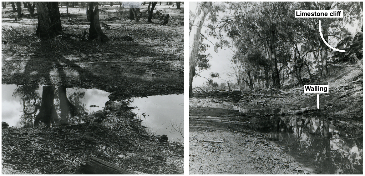
However, despite the widespread and frequent accounts, few extant examples of traps or weirs have been reported in the MDB. This is perhaps unsurprising, given the natural decay of plant materials commonly used in their construction, the inundation of floodplains following the construction of locks, and active erosion along the channels the traps and weirs had been constructed on. Within the general area of the Riverland, Pretty (1977) reported a fish trap near McBean Pound that had been constructed out of limestone blocks across a narrow (2.5 m wide) flood runner at the outer edge of the floodplain. Two images taken by Pretty of this structure are reproduced in Fig. 2. The weir measured ~0.75 m at its base and was 0.6 m high (Pretty 1977). This remains the only reported physical example of a weir in the greater Riverland region.
The study site
The Calperum feature is shown in Fig. 3. The feature was identified during archaeological research conducted by Westell (2022) and designated as Site CAPR17_08. An initial site plan identified key features and other content in the site and was referenced to hand-held GPS coordinates. A subsequent real-time kinematic positioning (RTK) survey was conducted across the site and adjoining area by using a Leica GS16/CS35 receiver/tablet combination. A digital elevation model (DEM) was constructed from this data by using Vertical Mapper software (ver. 3.0, Mapinfo Corporation). Additional detail was also added to the site plan at this time.
View looking west along the channel (increments on the range pole are 20 cm). Gravel spoil is visible outside the channel on either side of the range pole.

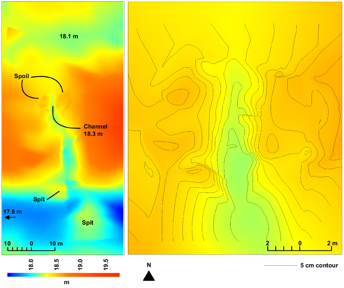
The site comprises a shallow, short (~9 m) excavation that deepens a natural swale within a sand ridge on a relic scroll plain of the Murray River. The swale forms a shallow flow path that connects seasonally inundated areas to the north of the ridge and a deeper basin to the south. The deep basin occupies several hectares and forms some of the lowest topography in this section of floodplain, being ~60 cm lower than the adjoining inundated flats and 80 cm deeper than the channel bed (Fig. 4). Given this topography, it is likely that a volume of water would naturally pool in the basin after flooding had receded. Sand spits have developed around the southern end of the swale (Fig. 4), a clear indication of currents flowing through the channel. Sediment collection around the northern end of the channel is less defined. The channel is ~1.5–2 m at its widest point and is 30–40 cm deep. A hard soil profile extends through the core of the sand ridge and is exposed in the swale and channel. Spoil extends several metres either side of the channel and is clearly visible in the DEM constructed on the RTK survey, as shown in Fig. 4.
(Left) The topography in the general area of the channel showing the spot elevations of the channel (18.3 m), the deep basin (17.4 m) and the seasonally inundated flat outside the channel inlet (18.1 m). (Right) Detailed topography across the channel and spoil heaps.
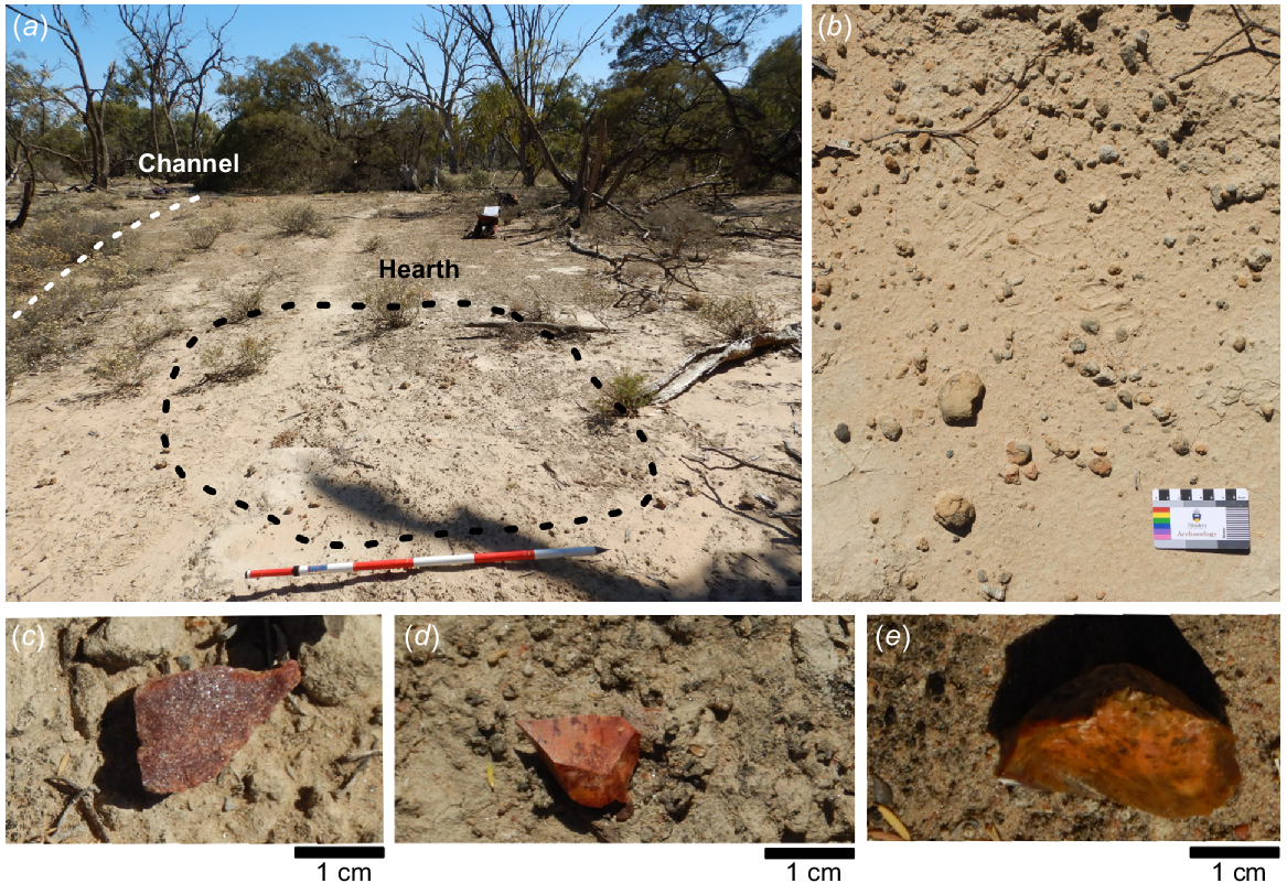
A low frequency concentration of chert and silcrete stone artefacts and baked clay heat retainers extends across the gentle slopes rising above both sides of the channel (Fig. 5, 6). The artefacts are typical of the flaked materials recorded in this region (e.g. Jones et al. 2017; Thredgold et al. 2017; Ross et al. 2019; Westell 2022). Importantly, a number of stone artefacts were noted on the surface of the spoil extending from the channel. This provides a relative chronology for the excavation, i.e. pre-European, regardless of whether the artefacts were placed on top of the spoil or represent a lag deposited out of the spoil.
Archaeological materials identified in the area of the channel, including (a) view looking east across an eroding hearth, (b) baked sediment heat retainer, and (c–e) silcrete and chert flakes.
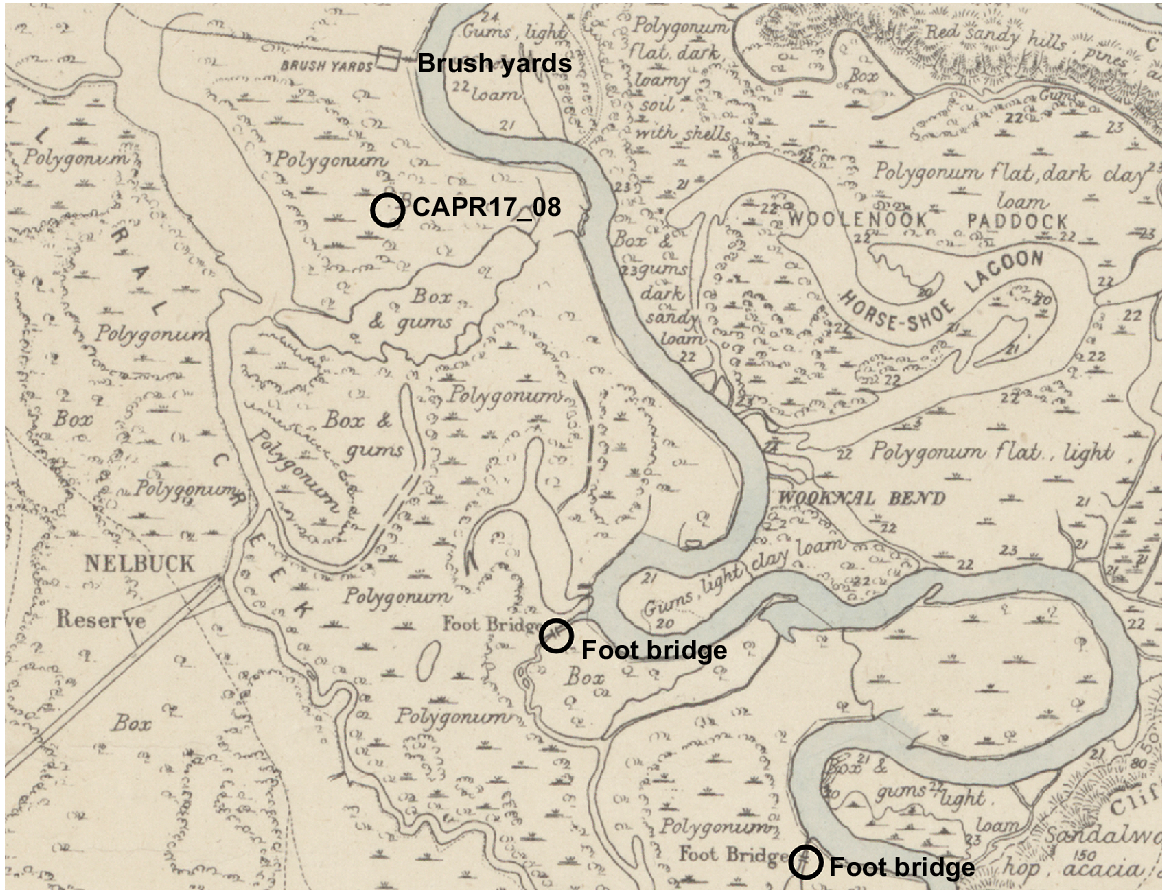
A survey map of the area c. 1891 (Vaughan 1891) shows ‘brush yards’ ~1 km to the north and various tracks on Calperum Station (Fig. 7). None of these tracks intersects the channel and no other historical infrastructure is shown in the immediate area. Interestingly, two ‘foot-bridges’ are also labelled on the map ~3 and 5 km downstream of the Calperum site. These foot-bridges are located on more substantive flood-runners and are both positioned ~200 m upstream of the junction with the Murray River. The annotation of ‘foot-bridges’ on this c. 1891 map is noteworthy, given the reference to ‘fish-trees’ near Renmark (see above) and the use of similar structures as foot-bridges in other parts of the MDB (Gilmore 1935).
The location of CAPR17_08 in relation to ‘foot bridges’ and brush yards depicted in Vaughan (1891).
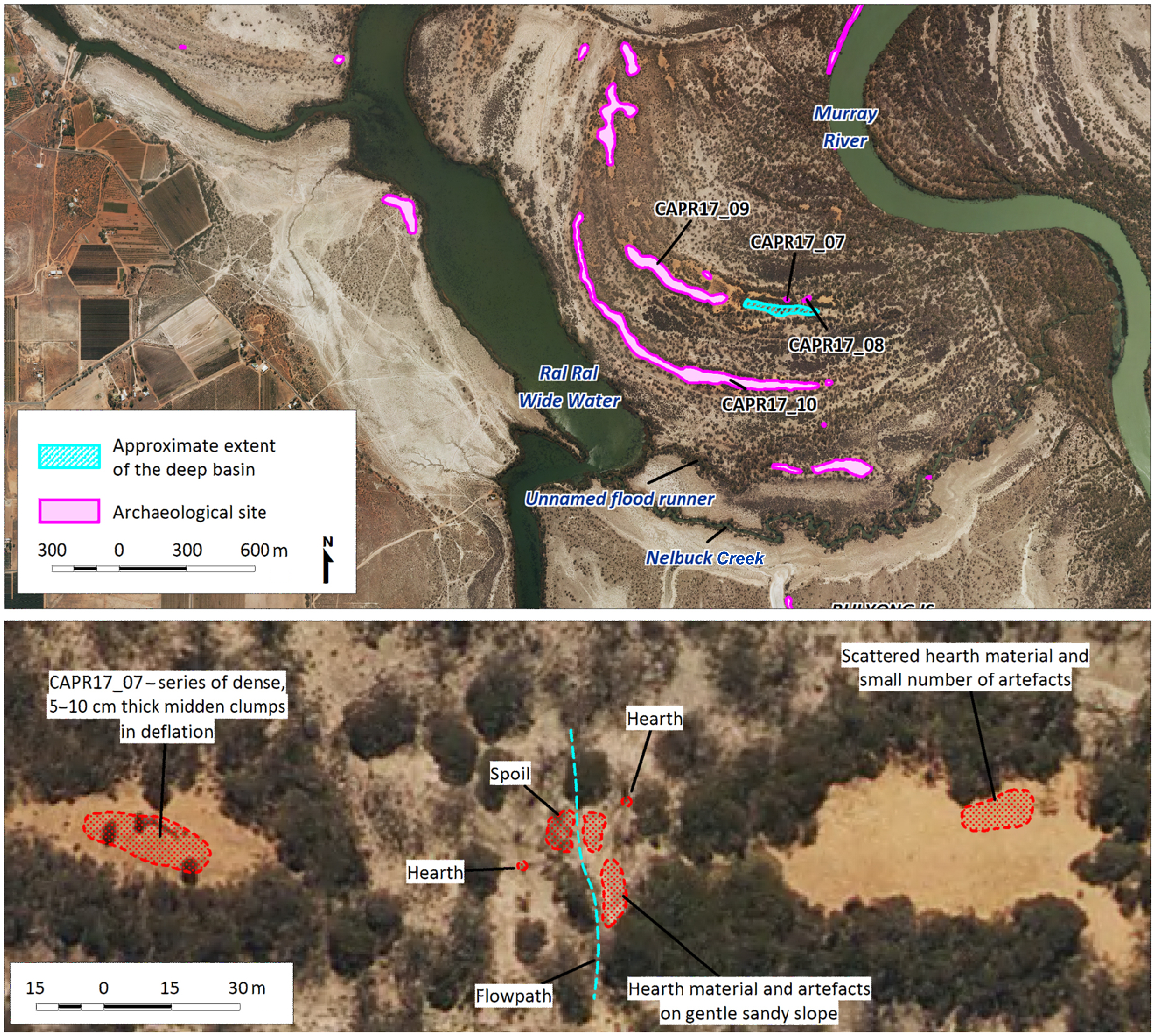
The channel lies on the periphery of a complex of Aboriginal occupation and burial sites extending along the eastern side of the Ral Ral Wide Water oxbow and into the low-lying flats around the margins of the lagoon (Fig. 6). This complex includes some of the most extensive archaeological sites at Calperum and, on this basis, Westell (2022) referred to the area as an occupation ‘node’ in the broader floodplain. A series of calibrated radiocarbon ages (cal BP) returned on freshwater mussel (Velesunio ambiguus) shell from these sites span the period from ~1300 to 450 cal BP (Westell et al. 2020; Westell 2022). A similar age range was reported by Jones et al. (2022) on an oven-mound (RRWWS3) located on the northern end of the Ral Ral Wide Water oxbow. As shown in Fig. 6, CAPR17_08 is associated with small exposures of dense shell midden, artefacts and hearth materials in dune swales immediately east and west of the site. Given this context, the impression is of intensive Aboriginal occupation centred on the Ral Ral oxbow over the past 1300 years, and within this, a highly focussed and unique activity centred on a discrete outlier in the form of CAPR17_08.
Hydrological setting
The placement and operation of weirs and fish traps would have been dictated by the natural variation in yearly and longer-term flooding overlain onto inherently complex floodplain topographies. In effect, no location would experience predictable flood responses year in and year out. Access to these sites would also vary. Given this, a degree of flexibility may have been embedded in this form of economic strategy, with various options activated in response to each unique seasonal flood scenario.
Bathymetry and FIMs have been used in studies elsewhere in Australia to reconstruct and interpret the operation and season(s) of fish-trap use (e.g. van Waarden and Wilson 1994; Builth 2002; Gippel et al. 2006; Richards 2013) and to suggest the age of structures by comparing their elevations with palaeo-sea level curves (Kreij et al. 2018). A FIM and observations of the 2022–23 flood event are applied here to indicate the flooding scenarios in which the Calperum channel may have operated. FIMs are essentially based on elevation, although they also consider water connectivity within the topography. Areas of floodplain only fill, for instance, when the sill heights of any obstructions along the interconnected flow paths are breached. The impact of land cover on movement of water through the landscape is also considered in the FIM. Fig. 8 shows a series of FIMs in the area of CAPR17_08 relating to flow rates observed in the Murray River at return periods of between 1 and 10 years under natural (unregulated) flows. The FIM outputs were generated using the pike floodplain hydrodynamic model as detailed in Department for Environment and Water (2021). The model was developed in the MIKE FLOOD software package (DHI Group 2022), with the topographic elevation being based on the latest DEM available for the region (Austin and Gallant 2010). The DEM was supplemented with bathymetric surveys of the River Murray and wetland channels collected from a variety of sources to generate a flexible mesh for the model, with some estimation of channel elevations necessary in the absence of data. Detailed calibration of the model was performed against a number of flow bands of up to 90 GL day−1 flow to South Australia (QSA), which represented the approximate peak QSA flow in the 2010–11 high-flow event. Validation of the FIM outputs at flood flows (i.e. over 100 GL day−1) was performed using water-level records available at the lock and weir structures for historical flood events of various sizes. The model was run in a ‘without development’ condition, with all modern infrastructure removed. Note that the inundation extent for a given flow should be considered as an approximation only because of a number of factors that affect the water level to flow relationship in the system. Owing to the relative coarseness of the mesh compared with the DEM, there may be localised connectivity issues within the mesh that may affect the commence-to-flow level in specific areas of the landscape. The data used to validate the model at flood flows were captured during periods with some level of development in the landscape (e.g. levee banks for flood protection), in contrast to a natural, pre-development condition of the basin. The hydraulics of a given flood event are also affected by the antecedent conditions within the system, which may affect the characteristics of the event such as the amount of loss occurring as the peak moves through the system, and the duration of the peak. Flow was also modelled to steady-state conditions, which may result in a greater extent of inundation than a sharper, transient flood peak. These impacts may contribute to a higher water level, and therefore greater inundation extent, for a given flow than the levels experienced in the basin under a natural state.
The channel feature in relation to FIMs calculated at flood-return periods of 1–2 years (75 GL day−1), 3 years (95 GL day−1), 4 years (110 GL day−1) and 10 years (167 GL day−1). Also shown are the return periods and durations of flood heights to ~160 GL day−1 (on the basis of data provided in Bloss et al. 2015 and Ecological Associates and Australian Water Environments 2008).
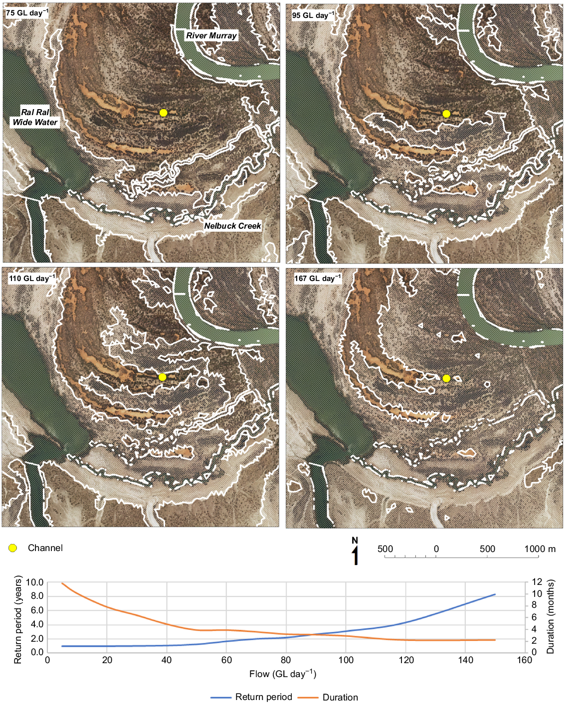
It is also important to note that the return periods for each flow rate are based on relatively recent (i.e. within the past 100 years) instrumental records and do not necessarily reflect return periods that may have occurred under hydroclimatic conditions different from those at the present. In addition, the model, which essentially translates flow rates into inundation extents, does not consider changes that are likely to have occurred in the configuration of the Murray River channel or the landscape topography over time. These points represent important caveats in relation to the functioning of the channel, because the feature may have been constructed during a flooding regime that differed from the system observed in instrumental records. Westell (2022), for instance, suggested that regular higher flows may have persisted in the Murray River over a brief period c. 500 years before present (see also Stone 2006; Tibby et al. 2018). It is also likely that, without ongoing maintenance, the channel may have infilled. The current base level should, therefore, be seen as an approximation only.
On the basis of the various FIM scenarios, seasonal flows rising to 110 GL day−1 gradually fill the lower parts of the floodplain in the area of the channel. Without the blocking effect of the sand ridges, the deep basin to the south of the channel would fill at significantly lower flows than this. The lowering of the swale, even by 20–30 cm, is likely to have seen water occupy the channel at flows of between 95 and 110 GL day−1, i.e. at a return period of roughly one in 2 or 4 years, but again, some flexibility is required here to accommodate potential infilling of the channel. This scenario was essentially replicated in the 2022–23 flood event, as captured in satellite imagery available through the Sentinel Hub EO Browser facility (see https://apps.sentinel-hub.com/eo-browser/). Water had extended into low-lying areas at both ends of the channel by 17 November 2022 at a flow rate approaching 108 GL day−1.1 The swale and channel were filled in the next cloud-free image taken on 2 December 2022. On the basis of an approximated water line and the RTK-derived DEM, the channel and swale had filled to a depth of between 1.2 and 1.3 m by this time. By interpolating the flow rates and water heights, the base of the channel would have been wet at a flow rate slightly higher than 108 GL day−1. In an unregulated system, floods of this magnitude would have occurred at a return period of 1 in 2 or 3 years on the basis of the available data, and water levels would be expected to remain at or above this level for a minimum of 3 months during these events. It remains conjecture as to whether the channel would have been utilised over this entire period or during specific phases within a flooding cycle.
Results and discussion
Historical accounts suggest that Aboriginal fish traps, weirs and other forms of water management had been commonplace in the MDB. However, these sites are rarely preserved. The common use of organic materials in their construction (see McNiven and Lambrides 2021), the erosive nature of their settings and the destruction of sites are likely to have contributed to a cumulative loss of this form of place-making in the archaeological record. The Calperum site, for instance, is unique in the documented archaeology both at Calperum and within the broader Riverland. The location of the feature is atypical of other descriptions where fish traps and weirs were strategically placed along more substantive waterways, for example, flood-runner creeks and inlet streams to lagoons and lakes. The channel may have also ‘operated’ under flows with minimum return periods of 2–4 years, accounting for potential differences in the water level to flow relationship in the channel occurring between natural and recent conditions.
Given this context, the question is what purpose the channel may have served. In this case, the excavation of a shallow channel represents a subtle modification in the natural topography that would have improved water connectivity between two seasonally inundated areas of floodplain. This included a deep basin, which seems inconsequential in terms of the broader floodplain, although it is noticeably deep; is bounded by higher topography and it is certain to retain water after flooding in the surrounding areas recedes (as observed in the Sentinel Hub EO image 31 January 2023). The basin is also located within an area of the floodplain containing extensive archaeology and seems to represent a discrete and distinctive activity-point within this broader site complex.
Two suggestions are canvassed here. The first is that the channel formed part of a more complex trap structure, perhaps spanning the broader swale and fitted with stakes in a similar fashion as that observed by Harris Browne at Overland Corner (see above). Fish migrating along the augmented flow path could be speared, scooped or netted. It is evident that fish migrate into this seasonally inundated area of the scroll plain as fish remains (from natural mortality) were noted close to the northern end of the channel (field notes, C. Westell, 11 October 2019). Alternatively, the channel may have simply improved fish movement into the deeper basin, in essence stocking a long-lasting pool or pen. Although some fish remains were located in Site CAPR17_10 (see Westell 2022), there is, admittedly, no corroborating evidence in the associated archaeology to suggest the intensive collection of fish. However, in comparing descriptions of site content from various historical media accounts to the extant archaeology at Calperum, Westell (2022) suggested that the preservation of animal bone in open sites may be compromised, at least to some extent. On this basis, the potential use of this feature in the capture or management of fish cannot be discounted on the basis of a paucity of fish remains in the associated archaeology.
The antiquity of the feature also remains uncertain. At this stage, the occurrence of stone artefacts on top of the spoil from the channel excavation provides a relative chronology only. If the channel had been regularly maintained, it might also be expected that sediments would have been repeatedly turned over, thereby complicating the use of optically stimulated luminescence and radiocarbon methods. However, these options should be considered in any further analysis of the site, ideally in combination with an excavation of the spoil heaps themselves. The large number of radiocarbon age estimates returned on archaeological materials (shell and charcoal) from sites in the immediate area are constrained to approximately the past 1300 years (Westell et al. 2020; Westell 2022), and in lieu of any direct dating of the feature itself, a similar timeline is currently assumed for the channel. It should also be noted, again, that the site lies at the centre of a discrete group a small scatters of midden shell, hearth material and stone artefacts that continue along the sand ridge either side of the channel. This association provides further circumstantial evidence in support of the channel having been excavated prior to European invasion.
Conclusions
A rare archaeological example of Aboriginal earthworks is described in this paper and is attributed to the management of water flows in a seasonally inundated area of the Calperum floodplain. On the basis of an extensive corpus of historical data, the feature is interpreted as either a trap where fish were actively caught by spear or nets, or a weir structure that regulated water (and fish) movement within the interior of the scroll plain. Fish traps and weirs in the greater MDB are known to have been constructed and maintained through communal efforts and ultimately supported the intensive, albeit seasonal, harvesting of fish to the benefit of large groups of people. The social role and implications of this economic strategy have been highlighted in examples of fish traps both within, and beyond, the MDB (e.g. Lourandos 1980, 1983; McNiven and Lambrides 2021). In this regard, it is notable that the Calperum feature lies on the periphery of an archaeological ‘node’ within the Calperum floodplain archaeology, that includes several major cemeteries, i.e. places of ritual significance.
A FIM has been applied here to suggest the flooding scenarios in which the channel would have potentially operated. However, FIMs are based on instrumental records and do not factor in the longer-term changes that are certain to have occurred in the configuration of the floodplain or in hydrological regimes. In this respect, archaeological sites that have a clear relationship to flooding regimes, such as fish traps, could potentially be used to inform or scrutinise hydrological models. Ultimately, the Calperum site lends an appreciation to the diversity and complexity in Aboriginal lifeways and supports an impression gained though historical accounts of a curated and managed riverscape, i.e. a riverscape abounding with multiple-layered uses and meanings (Roberts et al. 2017; Roberts et al. 2023).
Acknowledgements
This paper is based on PhD research conducted by Craig Westell in collaboration with the River Murray and Mallee Aboriginal Corporation (RMMAC) and approved by Flinders University’s Social and Behavioural Research Ethics Committee (Project Number: 6618). The authors sincerely thank all of the RMMAC members who participated in the fieldwork for this project and the RMMAC Directors who have supported this work. The authors specifically thank RMMAC members Angus Giles, Julie Cook, Jason Johnson and Winnie Johnson, and Flinders University volunteers and staff including Robert Jones, Marc Fairhead and Catherine Morton. Thanks also go to William Trueman for providing reference material and Lea Gardam (Archives Collections Manager, South Australian Museum) for her help in locating images of the McBean Pound site reproduced in this paper.
References
Austin J, Gallant J (2010) Stitching elevation and bathymetry data for the Murray River and Lower Lakes, South Australia. CSIRO Water for a Healthy Country Flagship, Technical Report EP105652. (CSIRO Land and Water) Available at http://hdl.handle.net/102.100.100/106228?index=1
Beveridge P (1883) Of the Aborigines inhabiting the great Lacustrine and Riverine depression of the Lower Murray, Lower Murrumbidgee, Lower Lachlan and Lower Darling. Proceedings of the Royal Society of New South Wales 17, 19-74.
| Google Scholar |
Builth H, Kershaw AP, White C, Roach A, Hartney L, McKenzie M, Lewis T, Jacobsen G (2008) Environmental and cultural change on the Mt Eccles lava-flow landscapes of southwest Victoria, Australia. The Holocene 18, 413-424.
| Crossref | Google Scholar |
DHI Group (2022) MIKE FLOOD, Urban, coastal and riverine flooding. Available at https://www.mikepoweredbydhi.com/products/mike-flood [Verified January 2022]
Dix WC, Meagher SJ (1976) Fish traps in the south-west of Western Australia. Records of the Western Australian Museum 4, 171-187.
| Google Scholar |
Dortch J, Dortch C, Reynolds R (2006) Test excavation at the Oyster Harbour Stone Fish Traps, King George Sound, Western Australia: an investigation aimed at determining the construction method and maximum age of the structures. Australian Archaeology 62, 38-43.
| Crossref | Google Scholar |
Finniss HJ (1966) Dr Harris Browne’s journal of the Sturt Expedition, 1844–45. South Australiana 5, 23-54.
| Google Scholar |
Humphries P (2007) Historical Indigenous use of aquatic resources in Australia’s Murray–Darling Basin, and its implications for river management. Ecological Management & Restoration 8, 106-113.
| Crossref | Google Scholar |
Jones R, Morrison M, Roberts A, the River Murray and Mallee Aboriginal Corporation (2017) An analysis of Indigenous earth mounds on the Calperum Floodplain, Riverland, South Australia. Journal of the Anthropological Society of South Australia 41, 18-62.
| Google Scholar |
Jones R, Roberts A, Westell C, Moffat I, Jacobsen G, Rudd R (2022) Aboriginal earth mounds of the Calperum Floodplain (Murray–Darling Basin, South Australia): new radiocarbon dates, sediment analyses and syntheses, and implications for behavioural change. The Holocene 32, 816-834.
| Crossref | Google Scholar |
Kreij A, Scriffignano J, Rosendahl D, Nagel T, Ulm S (2018) Aboriginal stone-walled intertidal fishtrap morphology, function and chronology investigated with high-resolution close-range unmanned aerial vehicle photogrammetry. Journal of Archaeological Science 96, 148-161.
| Crossref | Google Scholar |
Lourandos H (1980) Change or stability? Hydraulics, hunter-gatherers and population in temperate Australia. World Archaeology 11, 245-264.
| Crossref | Google Scholar |
Lourandos H (1983) Intensification: a Late Pleistocene–Holocene archaeological sequence from southwestern Victoria. Archaeology in Oceania 18, 81-97.
| Crossref | Google Scholar |
Martin S, Chanson H, Bates B, Keenan-Jones D, Westaway MC (2023) Indigenous fish traps and fish weirs on the Darling (Baaka) River, south-eastern Australia, and their influence on the ecology and morphology of the river and floodplains. Archaeology in Oceania 58, 91-114.
| Crossref | Google Scholar |
Mathews RH (1903) The aboriginal fisheries at Brewarrina. Journal and Proceedings of the Royal Society of New South Wales 37, 146-156.
| Google Scholar |
McNiven IJ, Bell D (2010) Fishers and farmers: historicising the Gunditjmara freshwater fishery, western Victoria. The La Trobe Journal 85, 83-105.
| Google Scholar |
McNiven IJ, Lambrides ABJ (2021) Stone-walled fish traps of Australia and New Guinea as expressions of enhanced sociality. In ‘The Oxford Handbook of the Archaeology of Indigenous Australia and New Guinea’. (Eds IJ McNiven, B David) (Oxford University Press) doi:10.1093/oxfordhb/9780190095611.013.49
McNiven IJ, Crouch J, Richards T, Dolby N, Jacobsen G (2012) Dating Aboriginal stone-walled fishtraps at Lake Condah, southeast Australia. Journal of Archaeological Science 39, 268-286.
| Crossref | Google Scholar |
Roberts A, Mollenmans A, Agius Q, Graham F, Newchurch J, Rigney L-I, Sansbury F, Sansbury L, Turner P, Wanganeen G, Wanganeen K (2016) ‘They planned their calendar… they set up ready for what they wanted to feed the tribe’: a first-stage analysis of Narungga fish traps on Yorke Peninsula, South Australia. The Journal of Island and Coastal Archaeology 11, 1-25.
| Crossref | Google Scholar |
Roberts A, van Duivenvoorde W, Morrison M, Moffat I, Burke H, Kowlessar J, Naumann J, the River Murray and Mallee Aboriginal Corporation (2017) ‘They call ‘im Crowie’: an investigation of the Aboriginal significance attributed to a wrecked River Murray barge in South Australia. The International Journal of Nautical Archaeology 46, 132-148.
| Crossref | Google Scholar |
Roberts A, Westell C, Fairhead M, Lopez JM, River Murray and Mallee Aboriginal Corporation (2023) ‘Braiding knowledge’ about the peopling of the River Murray (Rinta) in South Australia: ancestral narratives, geomorphological interpretations and archaeological evidence. Journal of Anthropological Archaeology 71, 101524.
| Crossref | Google Scholar |
Ross D, Morrison M, Simyrdanis K, Roberts A, Moffat I, the River Murray and Mallee Aboriginal Corporation (2019) A geophysical analysis of Aboriginal earth mounds in the Murray River Valley, South Australia. Archaeological Prospection 26, 313-323.
| Crossref | Google Scholar |
Rowland MJ, Ulm S (2011) Indigenous fish traps and weirs of Queensland. Queensland Archaeological Research 14, 1-58.
| Crossref | Google Scholar |
Thredgold J, Roberts AL, the River Murray and Mallee Aboriginal Corporation (2017) Stone artefacts and earth mounds at Calperum Station, South Australia, together with a consideration of comparative Murray–Darling Basin data. Journal of the Anthropological Society of South Australia 41, 93-122.
| Google Scholar |
Tibby J, Tyler JJ, Barr C (2018) Post little ice age drying of eastern Australia conflates understanding of early settlement impacts. Quaternary Science Reviews 202, 45-52.
| Crossref | Google Scholar |
Traill M (2017) An astonishing technology: Aboriginal fish traps on the south coast. Early Days: Journal of the Royal Western Australian Historical Society 101, 13-34.
| Google Scholar |
van Waarden N, Wilson B (1994) Developing a hydrological model of the Lake Condah fish traps in western Victoria using GIS. In ‘Methods in the mountains’. (Ed. I Johnson) pp. 81–90. (Archaeological Computing Laboratory, Department of Prehistoric and Historical Archaeology, The University of Sydney: Sydney, NSW, Australia)
Walters I (1985) The Toorbul Point Aboriginal fish trap. Queensland Archaeological Research 2, 38-49.
| Crossref | Google Scholar |
Westell C, Roberts A, Morrison M, Jacobsen G, the River Murray and Mallee Aboriginal Corporation (2020) Initial results and observations on a radiocarbon dating program in the Riverland region of South Australia. Australian Archaeology 86, 160-175.
| Crossref | Google Scholar |
Footnotes
1 Flow rates are based on the relevant South Australian River Murray Flow Report available at https://www.sawater.com.au/water-and-the-environment/south-australias-water-sources/river-sources/river-reports-daily-flow.