

Road orientation affects the impact of roads on wildlife
Margarita Mulero-Pázmány A B * , Laura Rollán C , Marcello D’Amico D E and Manuela González-Suárez F
A Department of Animal Biology, Facultad de Ciencias, University of Málaga, 29071 Málaga, Spain.
B School of Biological and Environmental Sciences, Liverpool John Moores University, 3 Byrom Street, Liverpool L3 3AF, UK.
C Cybertracker Conservation, Plaza del Comercio 2, 21750 El Rocío, Huelva, Spain.
D CIBIO-InBIO, School of Agriculture, University of Porto and University of Lisbon, Tapada da Ajuda Campus, 1349-017 Lisbon, Portugal.
E Present address: Department of Conservation Biology, Doñana Biological Station CSIC, C/Américo Vespucio 26, 41092 Seville, Spain.
F Ecology and Evolutionary Biology, School of Biological Sciences, University of Reading, Reading RG6 6EX, UK.
Wildlife Research 50(1) 39-46 https://doi.org/10.1071/WR21149
Submitted: 12 October 2021 Accepted: 16 April 2022 Published: 14 July 2022
© 2023 The Author(s) (or their employer(s)). Published by CSIRO Publishing. This is an open access article distributed under the Creative Commons Attribution 4.0 International License (CC BY)
Abstract
Context: Understanding the factors determining the impacts of roads and how they fragment landscapes limiting the movement of animals, is key to implement efficient mitigation measures.
Aims: Here we investigate if road orientation in relation to limiting resources, a largely overlooked factor on road impact assessments, can influence the movement of animals within a landscape where water resources are spatially clustered.
Methods: We evaluated movement by monitoring animal tracks on unpaved roads: two with a North–South orientation and two with an East–West orientation.
Key results: Animals were more likely to follow roads leading to limiting resources (i.e. East–West orientation), confirming human linear structures can facilitate wildlife movements. Carnivores were more likely to follow roads with any orientation and for longer compared to ungulates, whereas ungulates followed roads mainly in the orientation of limiting resources.
Conclusions: Road orientation affects how roads influence the movement of animals in landscapes where resources are distributed along a spatial gradient with different effects for ungulates and carnivores.
Implications: The key implications of this work affect the planning and implementation of mitigation strategies and safety measures. Our results suggest road-crossing infrastructure and fences will be most important in roads traversing a gradient to allow wildlife movement while preventing collisions. For roads along a gradient, crossing structures may be less important, but fences or appropriate signage could be useful to prevent or warn drivers of animals travelling on the road.
Keywords: animal movement, habitat fragmentation, landscape connectivity, mitigation, road ecology, roadkill, track census, wildlife collisions.
Introduction
Roads fragment landscapes, contribute to ecosystem degradation and threaten biodiversity (Bennett 2017). These linear structures are expected to increase by more than 60% globally by 2050 (Meijer et al. 2018), therefore, understanding the factors determining their impact on wildlife before they are designed and built is crucial to minimise environmental impact and reduce human safety risks along with the financial implications of wildlife collisions (Diaz-Varela et al. 2011; Мorelle et al. 2013; Rytwinski et al. 2016; Visintin et al. 2018; Ascensão et al. 2019a). The most studied road impacts for wildlife are roadkill and fragmentation, both consequences of an animal choice to cross or avoid a road (Grilo et al. 2012). Their interaction produces the so-called barrier effect, which contributes to subdivide and isolate animal populations (Grilo et al. 2012) eventually compromising their viability (Ceia-Hasse et al. 2017). How roads affect wildlife depends on which species are in an area, their characteristics, and their local abundance (Jacobson et al. 2016; Visintin et al. 2016; González-Suárez et al. 2018; Ascensão et al. 2019a; Duffett et al. 2020), as well as on traffic and road properties (e.g. road width, traffic speed) and the characteristics of the surrounding environment (Borkovcová et al. 2012; D’Amico et al. 2015; Visintin et al. 2016). While diverse factors related to road properties and surrounding environment have been studied, there is still a gap in the literature regarding how the spatial properties of roads, such as their orientation in relation with limiting resources for animals, can influence how roads impact wildlife.
The objective of this work was to fill this gap evaluating how a largely overlooked aspect of road design, orientation, affects the impact of these linear structures on wildlife. To achieve this goal, we conducted a study within a Mediterranean ecosystem, in which water is a limiting resource that shows strong spatial aggregation. Road orientation can be important because limiting resources for animals, such as water, are often associated to geographical features (e.g. rivers, mountain chains or coastlines) that form landscape gradients. These gradients result in periodic movements of animals to and from resources that may occur across different spatio-temporal scales, from individual daily movements connecting water/refuge/food to large seasonal migrations to track fresh pastures. Therefore, we predict that in landscapes with a resource gradient, such as our study area, animals will respond differently to roads that run along the gradient compared to those that intersect it. In general, we expect that animals could either avoid completely, or alternatively use as movement corridors, roads that run along the gradient, while roads that intersect the gradient, i.e. blocking their access to the resources, will have to be regularly crossed but will rarely be used as travel corridors.
Additionally, we anticipate that different species groups will be influenced differently by road orientation. To test this possibility, we studied two groups of mammals: large herbivores and carnivores for which we predict different responses. Herbivores, namely ungulates, are dependent on primary productivity and regularly move across the landscape water gradient, but previous work suggest they may avoid roads (D’Amico et al. 2016). Conversely, carnivores’ movements are less influenced by water and pasture resources and previous work suggests they can be attracted to roads and use these for travelling and marking (Whittington et al. 2011). Thus, we predict carnivores will use and travel on roads more often and be less affected by their orientation as their movement across the landscape is not strongly directional. Large herbivores, which are those most often involved in deadly collisions (Bissonette et al. 2008), are expected to cross roads traversing the gradient and could either avoid or travel along those roads that link resources.
Our study provides new understanding regarding how wildlife is affected by road design, in particular orientation within the landscape. When designing a road, its orientation will largely be determined by the need to connect areas and relevant socioeconomic factors, yet, even if overall orientation is unlikely to be flexible, mitigation measures and safety guidance (e.g. speed limits and signage) could be adapted to reduce impact to wildlife and humans. Understanding how orientation influences the movement of wildlife can anticipate the probability of animals crossing roads or moving along them, behaviours which pose different challenges to wildlife and human safety. Here we offer insights to promote more effective mitigation strategies, with implications for sustainable road management and wildlife conservation.
Materials and methods
Study area
Our study was carried out in Doñana Biological Reserve, a management unit of 6794 ha with the highest level of environmental protection in the core of the Doñana Natural Area. The Doñana Natural Area (36°59′N, 6°26′W) comprises both National and Natural Parks, and is located in the Guadalquivir river estuary, in the Atlantic coast of South-western Spain (Fig. 1). The climate is Mediterranean sub-humid with marked seasons (i.e. hot dry summer and mild winter, with precipitations mainly during winter and spring). Doñana Biological Reserve hosts three main ecosystems: sandy dunes; Mediterranean shrubland/forest; and marshland in the eastern area of the reserve (Fig. 1). During summer (June–September) most available water and pastures are concentrated along the ecotone between Mediterranean shrubland/forest and marshland, that runs mainly in a North–South direction within the Biological Reserve. Ungulate species in this area include wild boar Sus scrofa, feral cattle Bos taurus, red deer Cervus elaphus, feral horse Equus caballus, and fallow deer Dama dama (listed in approximate order of abundance; Castroviejo 1993). Carnivore species include red fox Vulpes vulpes, large grey mongoose Herpestes ichneumon, European badger Meles meles, feral dog Canis lupus familiaris, small-spotted genet Genetta genetta, feral cat Felis silvestris catus, Iberian lynx Lynx pardinus, Eurasian otter Lutra lutra, and European wildcat Felis silvestris (listed in approximate order of abundance; Castroviejo 1993). Doñana Natural Area has a heterogeneous road-network mostly composed by unpaved sandy roads that were built according to the transportation needs for humans (i.e. park management, historical reasons), with low traffic volume (∼10 vehicles/day; Román et al. 2010).

|
Data collection and variables definition
Within Doñana Biological Reserve, we selected a section of 50 m length in each of four unpaved roads (with sandy soil) close to the ecotone between Mediterranean shrubland/forest and marshland. Two of the surveyed roads run North–South (2° and 4°) perpendicular to the landscape water gradient. The other two roads run East–West (82° and 89°) in parallel with landscape water gradient (Fig. 1).
During 10 days in June–July 2019 we monitored ungulate and carnivore tracks on the selected road sections daily. The day before starting the data collection, we swept the sand in each road section using a heavy piece of wood pulled by a 4 × 4 vehicle to create a clean and homogeneous surface. Then, each road section was swept with a broom daily after tracks were recorded to avoid double counting them on subsequent days. Every sampling day, soon after sunrise, we surveyed the four road sections to record tracks starting each day on a different road section. For each track found we recorded: the species (when possible) or species group (i.e. ungulates or carnivores), the angle of the track where entering the road section and the angle where exiting it (recorded with a compass), track length within the road section (measured in metres with a tape), and described the speed of the animal that made the track as gait type: walk, trot, gallop. For each road section, we also visually estimated and recorded the percentage of shrub coverage in the band of 3 m adjacent to the roads because vegetation may affect animal movement.
Because not all tracks could be identified to species, our analyses focused on the two species groups (ungulates and carnivores). Track speed was also reclassified in two levels for analyses: slow for tracks that only showed gait = walk, and fast for all others. Track movement type was classified in two levels based on the entrance and exit angles and the road orientation: cross for tracks where the animal had entered the road from one side and exited from the other (regardless of track length) and follow for tracks of >3 m in length where entrance and exit occurred from the same side of the road or were beyond the 50 m section (entrance or exit angle were not recorded). We excluded nine tracks with a length <3 m that we could not clearly classify as ‘cross’ or ‘follow’. Finally, track movement direction was defined as the travel direction (e.g. North–South or South–North) within the road for tracks with movement type = follow.
Data analyses
We fitted logistic mixed effects regression models using the glmer function from the lme4 package in R (R Foundation for Statistical Computing 2013) to:
-
Predict the movement type (cross vs follow) of each observed track as a function of three predictors: road orientation, species group and estimated shrub coverage in the adjacent terrain of each road.
-
Predict the speed (fast vs slow) of each observed track as a function of three predictors: road orientation, species group and movement type, (we expected animals crossing to move faster than those following roads).
-
Predict the movement direction for animals following roads (movement type = follow) for each road orientation (one model for each orientation) as function of two predictors: species group and speed.
-
Predict the track length, a proposed proxy for the duration of road travel, for animals following roads (movement type = follow) as a function of four predictors: road orientation, species group, movement speed and shrub coverage.
In models that included road orientation and species group as predictors, we tested for an interaction between these two predictors to explore differential responses. We report interaction terms if these were significant and otherwise report simpler additive models. In all fitted models we used observation date nested within transect ID (unique identifier for each of road sections) as a random factor to control for temporal and spatial non-independence of the track data.
Results
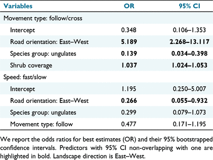
We analysed a total of 289 tracks (Table 1). Of these, 264 were made by ungulates including 24 by feral species (horses and cattle), 240 by wild species (wild boars, red and fallow deer) and 25 by carnivores (foxes, badgers, felids and other unidentified meso-carnivores). We found 132 tracks in East–West roads and 157 in North–South roads. A total of 163 tracks crossed the road and 126 followed its trajectory.

|
Animals moved differently on roads with different orientations being over five times more likely to follow and three times less likely to move fast on East–West roads compared to those with North–South orientation (Table 2, Figs 2, 3). Species differed in their use of roads, with carnivores being over seven times more likely to follow roads than ungulates and having a tendency (not significant) to move slower. However, groups did not differentially respond to road orientation: the interactions between road orientation and species group were not significant for movement type or speed. Finally, roads were used differently depending on the adjacent terrain and animals were more likely to follow roads in areas with more shrub coverage (Table 2).
|

|

|
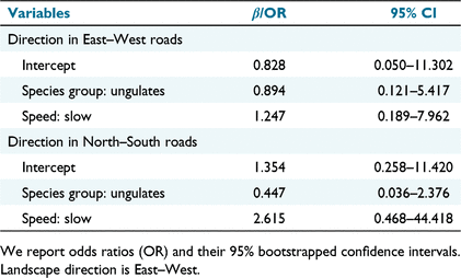
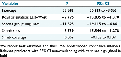
There were no differences in movement direction associated with species group or movement speed (Table 3). However, several factors influenced track length, and thus, presumably the time animals followed roads. In particular, tracks were longer in North–South roads, if they belonged to carnivores, and when left by animals moving faster (Table 4, Fig. 3).
|
|
Discussion
As predicted, our results showed that the movement of animals in relation to roads varies depending on the orientation of these structures, at least in landscapes where resources are spatially distributed along a gradient. We also found that ungulates and carnivores make different use of these structures, which suggests these groups could face different roadkill risk and fragmentation impacts.
Animals were more likely to follow roads along the environmental gradient that could be used to move to and from a key resource, which in this study area is freshwater. In semi-arid environments, wildlife depends highly on limited water (Kihwele et al. 2020), and many species travel daily to and from water and associated resources such as fresh pastures (Kasiringua et al. 2017). Our findings suggest that the animals may be taking advantage of existing roads for these movements, at least in the dry season when water is scarce. Several studies have described wildlife using roads, including some of the species we detected (e.g. wild boars and red foxes) (Macdonald 1979; Boughton et al. 2019). Roads can offer opportunities for foraging and marking behaviour (Monclús et al. 2009; Toger et al. 2018) and facilitate movement because they often present a flatter surface without vegetation or snow (Whittington et al. 2005; Brown et al. 2006). Indeed, we found that animals were more likely to follow unpaved roads in areas surrounded by more shrub coverage where movement may be hampered and left longer tracks when travelling faster because when flatter, obstacle-free terrain may be most important. However, wildlife may not use roads if these are heavily used by humans. In fact, wildlife are more likely to take advantage of roads with low traffic volume (Brown et al. 2006; Boughton et al. 2019), which is the case for our study area (10 vehicles/day; (Román et al. 2010). Similarly, wildlife can travel along heavily trafficked roads and associated roadsides during low-traffic periods, such as night-time for certain roads (Brown et al. 2006).
As hypothesised, the two species groups differed in their use of roads, with carnivores over seven times more likely to follow roads and doing so for longer compared to ungulates. Carnivore species have been shown to use roads for diverse purposes, including as travel corridors (Whittington et al. 2005), for territorial displays (Monclús et al. 2009), for hunting (Andersen et al. 2017) and scavenging (Barrientos et al. 2018). In our study area, red foxes are known to actively select roads for defecation, probably as a marking behaviour (Suárez-Esteban et al. 2013). Conversely, prey species, such as ungulates in our case study, are more likely to exhibit road-gap avoidance as part of their anti-predator behaviour (Laurance et al. 2004; Chen and Koprowski 2016). In agreement with a previous study in this area (D’Amico et al. 2016), we found that ungulates do sometimes use roads, with a tendency to follow East–West roads more than those oriented North–South. This suggests road use may be an acceptable risk when there is a benefit such as easier travel to and from limiting resources.
Previous studies have evaluated how road design and some related characteristics influence wildlife impacts. Road design depends on road alignment, profile and section (Garber and Hoel 2019). Regarding road alignment, both the presence of curves and road sinuosity can affect roadkill risk (Grilo et al. 2011; D’Amico et al. 2015). Similarly, regarding road profile, road slope can have an effect on roadkill probability (D’Amico et al. 2015; Kang et al. 2016). Many road features related to road section have been often considered as predictors of different road impacts, such as roadkill and fragmentation, for example road size and the presence of road shoulders or ditches (Matos et al. 2012; D’Amico et al. 2015; Jacobson et al. 2016). Our study is the first assessment of how road orientation in relation to key resources affects animal movement, which can ultimately influence landscape connectivity and direct impacts to wildlife and humans, but our approach had some limitations. First, we did not monitor animal tracks outside roads; thus, we could not test whether the studied species used roads differently from the natural landscape. However, our study design allowed us to compare the use on roads running both across and along the environmental gradient, testing the hypothesis that road use by animals could differ when both orientations are available. Second, our study area is small (<1 km2) and did not allow us to confirm that the patterns found here will apply to larger geographical scales. Studies addressing the consequences of animal movement on landscape connectivity are usually performed at a larger scale (landscape or regional, up to global) involving high economic costs (e.g. tagging or radio-marking several individuals of the target species; Blazquez-Cabrera et al. 2016) or complex modelling efforts (e.g. Ascensão et al. 2019b). Here, we used a smaller-scale approach that can represent a valuable first step to assess landscape connectivity with a relatively small effort, both economically and analytically. Third, the low traffic levels and the lack of pavement of the studied roads seem to facilitate animal movement along them, but effects may be different for busy or paved roads. Future research would be necessary to understand how different types of roads facilitate or prevent access of wildlife to spatially aggregated limiting resources and how this may affect landscape connectivity and ultimately the persistence of animal populations.
Our results have potential implications for the conservation and management of species and areas, and for human safety by helping in understanding the mechanisms potentially reducing wildlife-vehicle collisions. Roadkills occur when wildlife use roads, which we show can be influenced by road orientation, suggesting this aspect of road design should be considered as a factor affecting collision probability. Road orientation seems to influence particularly large ungulates, which due to their size pose the greatest risk to humans in case of a collision (Conover 2019). We recommend that mitigation measures should be prioritised for roads paralleling resource gradients as these may be preferably used by large ungulates to access limiting resources. Fenced roadsides could be designed to act as suitable corridors for ungulates, allowing for required movements to essential resources but limiting collision risks (Jakes et al. 2018). For roads that transverse the environmental gradient, wildlife road-crossing structures will be essential to ensure access to limiting resources. Finally, while road orientation may be primarily driven by human requirements (i.e. which areas need to be connected), whenever possible the construction of new roads in directional landscapes should consider road orientation in relation to key resources for wildlife to reduce the impact on animals movement and landscape connectivity.
Conclusion
The main finding of our study is that road orientation affects how these linear structures influence animal movement in landscapes where resources are distributed along a spatial gradient with distinct effects for ungulates and carnivores. When a road is planned and designed its orientation will be primarily determined by human needs and costs, although environmental impact assessments will also take into consideration aspects that we studied here such as animal movement and critical resources (Stokes 2015; Broniewicz and Ogrodnik 2020). However, we consider the key implications of our work affect the planning and implementation of mitigation strategies and safety measures. Our results suggest road-crossing structures and fences will be most important for roads traversing a gradient to allow wildlife movement while preventing collisions. For roads along a gradient, crossing structures may be less important, but fences or appropriate signage could be useful to prevent or warn drivers of animals travelling on the road.
Future work will be necessary to expand on our research by covering different areas with varying resource gradients, representing different species, and comparing roads with higher levels of traffic and other features (e.g. paved, multiple lanes). Additional work should also consider overcoming some of the limitations of our study, by including off-road data on animal movement and covering a wider region. Despite its limitations, our study expands our knowledge of how largely overlooked aspects of how roads are designed can affect animal movement and ultimately landscape connectivity.
Data availability
The data that support this study are available at https://doi.org/10.6084/m9.figshare.20032637.v1.
Conflicts of interest
The authors declare no conflicts of interest.
Declaration of funding
MM work was funded by European Union ‘NextGenerationEU’ (Programa María Zambrano, Ministerio de Universidades, Spain) and Liverpool John Moores University, UK. MD was supported by a post-doctoral grant from Fundação da Ciência e Tecnologia (CEECIND/03798/2017). Universidad de Málaga, Spain, provided funding to publish this article as open access.
Acknowledgements
Logistic and technical support was provided by ICTS-RBD-CSIC, Ministry of Science and Innovation and co-financed by FEDER Funds, and Instituto de Investigación en Recursos Cinegéticos Universidad de Castilla la Mancha (Consejo Superior de Investigaciones Científicas). We thank Jose María Galán (Espacio Natural Doñana) for his help on animal track identification. Doñana National Park registered project 2018/18.
References
Andersen, GE, Johnson, CN, Barmuta, LA, and Jones, ME (2017). Use of anthropogenic linear features by two medium-sized carnivores in reserved and agricultural landscapes. Scientific Reports 7, 11624.| Use of anthropogenic linear features by two medium-sized carnivores in reserved and agricultural landscapes.Crossref | GoogleScholarGoogle Scholar | 28912508PubMed |
Ascensão, F, Kindel, A, Teixeira, FZ, Barrientos, R, D’Amico, M, Borda-de-Água, L, and Pereira, HM (2019a). Beware that the lack of wildlife mortality records can mask a serious impact of linear infrastructures. Global Ecology and Conservation 19, e00661.
| Beware that the lack of wildlife mortality records can mask a serious impact of linear infrastructures.Crossref | GoogleScholarGoogle Scholar |
Ascensão, F, Mestre, F, and Barbosa, AM (2019b). Prioritizing road defragmentation using graph-based tools. Landscape and Urban Planning 192, 103653.
| Prioritizing road defragmentation using graph-based tools.Crossref | GoogleScholarGoogle Scholar |
Barrientos, R, Martins, RC, Ascensão, F, D’Amico, M, Moreira, F, and Borda-de-Água, L (2018). A review of searcher efficiency and carcass persistence in infrastructure-driven mortality assessment studies. Biological Conservation 222, 146–153.
| A review of searcher efficiency and carcass persistence in infrastructure-driven mortality assessment studies.Crossref | GoogleScholarGoogle Scholar |
Bennett, VJ (2017). Effects of road density and pattern on the conservation of species and biodiversity. Current Landscape Ecology Reports 2, 1–11.
| Effects of road density and pattern on the conservation of species and biodiversity.Crossref | GoogleScholarGoogle Scholar |
Bissonette, JA, Kassar, CA, and Cook, LJ (2008). Assessment of costs associated with deer–vehicle collisions: human death and injury, vehicle damage, and deer loss. Human-Wildlife Conflicts 2, 17–27.
| Assessment of costs associated with deer–vehicle collisions: human death and injury, vehicle damage, and deer loss.Crossref | GoogleScholarGoogle Scholar |
Blazquez-Cabrera, S, Gastón, A, Beier, P, Garrote, G, Simón, MÁ, and Saura, S (2016). Influence of separating home range and dispersal movements on characterizing corridors and effective distances. Landscape Ecology 31, 2355–2366.
| Influence of separating home range and dispersal movements on characterizing corridors and effective distances.Crossref | GoogleScholarGoogle Scholar |
Borkovcová, M, Mrtka, J, and Winkler, J (2012). Factors affecting mortality of vertebrates on the roads in the Czech Republic. Transportation Research Part D: Transport and Environment 17, 66–72.
| Factors affecting mortality of vertebrates on the roads in the Czech Republic.Crossref | GoogleScholarGoogle Scholar |
Boughton, RK, Allen, BL, Tillman, EA, Wisely, SM, and Engeman, RM (2019). Road hogs: implications from GPS collared feral swine in pastureland habitat on the general utility of road-based observation techniques for assessing abundance. Ecological Indicators 99, 171–177.
| Road hogs: implications from GPS collared feral swine in pastureland habitat on the general utility of road-based observation techniques for assessing abundance.Crossref | GoogleScholarGoogle Scholar |
Broniewicz, E, and Ogrodnik, K (2020). Multi-criteria analysis of transport infrastructure projects. Transportation Research Part D: Transport and Environment 83, 102351.
| Multi-criteria analysis of transport infrastructure projects.Crossref | GoogleScholarGoogle Scholar |
Brown, GP, Phillips, BL, Webb, JK, and Shine, R (2006). Toad on the road: use of roads as dispersal corridors by cane toads (Bufo marinus) at an invasion front in tropical Australia. Biological Conservation 133, 88–94.
| Toad on the road: use of roads as dispersal corridors by cane toads (Bufo marinus) at an invasion front in tropical Australia.Crossref | GoogleScholarGoogle Scholar |
Castroviejo J (1993) ‘Memoria: Mapa del Parque Nacional de Doñana.’ (Consejo Superior de Investigaciones Cientifícas (CSIC))
Ceia-Hasse, A, Borda-de-Água, L, Grilo, C, and Pereira, HM (2017). Global exposure of carnivores to roads. Global Ecology and Biogeography 26, 592–600.
| Global exposure of carnivores to roads.Crossref | GoogleScholarGoogle Scholar |
Chen, HL, and Koprowski, JL (2016). Differential effects of roads and traffic on space use and movements of native forest-dependent and introduced edge-tolerant species. PLoS ONE 11, e0148121.
| Differential effects of roads and traffic on space use and movements of native forest-dependent and introduced edge-tolerant species.Crossref | GoogleScholarGoogle Scholar | 26821366PubMed |
Conover, MR (2019). Numbers of human fatalities, injuries, and illnesses in the United States due to wildlife. Human–Wildlife Interactions 13, 12.
| Numbers of human fatalities, injuries, and illnesses in the United States due to wildlife.Crossref | GoogleScholarGoogle Scholar |
D’Amico, M, Román, J, de los Reyes, L, and Revilla, E (2015). Vertebrate road-kill patterns in Mediterranean habitats: who, when and where. Biological Conservation 191, 234–242.
| Vertebrate road-kill patterns in Mediterranean habitats: who, when and where.Crossref | GoogleScholarGoogle Scholar |
D’Amico, M, Périquet, S, Román, J, and Revilla, E (2016). Road avoidance responses determine the impact of heterogeneous road networks at a regional scale. Journal of Applied Ecology 53, 181–190.
| Road avoidance responses determine the impact of heterogeneous road networks at a regional scale.Crossref | GoogleScholarGoogle Scholar |
Diaz-Varela, ER, Vazquez-Gonzalez, I, Marey-Pérez, MF, and Álvarez-López, CJ (2011). Assessing methods of mitigating wildlife–vehicle collisions by accident characterization and spatial analysis. Transportation Research Part D: Transport and Environment 16, 281–287.
| Assessing methods of mitigating wildlife–vehicle collisions by accident characterization and spatial analysis.Crossref | GoogleScholarGoogle Scholar |
Duffett, D, D’Amico, M, Mulero-Pázmány, M, and González-Suárez, M (2020). Species’ traits as predictors of avoidance towards roads and traffic. Ecological Indicators 115, 106402.
| Species’ traits as predictors of avoidance towards roads and traffic.Crossref | GoogleScholarGoogle Scholar |
Garber NJ, Hoel LA (2019) ‘Traffic and highway engineering.’ (Cengage Learning)
González-Suárez, M, Zanchetta Ferreira, F, and Grilo, C (2018). Spatial and species-level predictions of road mortality risk using trait data. Global Ecology and Biogeography 27, 1093–1105.
| Spatial and species-level predictions of road mortality risk using trait data.Crossref | GoogleScholarGoogle Scholar |
Grilo, C, Ascensão, F, Santos-Reis, M, and Bissonette, JA (2011). Do well-connected landscapes promote road-related mortality? European Journal of Wildlife Research 57, 707–716.
| Do well-connected landscapes promote road-related mortality?Crossref | GoogleScholarGoogle Scholar |
Grilo, C, Sousa, J, Ascensão, F, Matos, H, Leitão, I, Pinheiro, P, Costa, M, Bernardo, J, Reto, D, Lourenço, R, Santos-Reis, M, and Revilla, E (2012). Individual spatial responses towards roads: implications for mortality risk. PLoS ONE 7, e43811.
| Individual spatial responses towards roads: implications for mortality risk.Crossref | GoogleScholarGoogle Scholar | 22970143PubMed |
Jacobson, SL, Bliss-Ketchum, LL, de Rivera, CE, and Smith, WP (2016). A behavior-based framework for assessing barrier effects to wildlife from vehicle traffic volume. Ecosphere 7, e01345.
| A behavior-based framework for assessing barrier effects to wildlife from vehicle traffic volume.Crossref | GoogleScholarGoogle Scholar |
Jakes, AF, Jones, PF, Paige, LC, Seidler, RG, and Huijser, MP (2018). A fence runs through it: a call for greater attention to the influence of fences on wildlife and ecosystems. Biological Conservation 227, 310–318.
| A fence runs through it: a call for greater attention to the influence of fences on wildlife and ecosystems.Crossref | GoogleScholarGoogle Scholar |
Kang, W, Minor, ES, Woo, D, Lee, D, and Park, C-R (2016). Forest mammal roadkills as related to habitat connectivity in protected areas. Biodiversity and Conservation 25, 2673–2686.
| Forest mammal roadkills as related to habitat connectivity in protected areas.Crossref | GoogleScholarGoogle Scholar |
Kasiringua, E, Kopij, G, and Procheş, Ş (2017). Daily activity patterns of ungulates at water holes during the dry season in the Waterberg National Park, Namibia. Russian Journal of Theriology 16, 129–138.
| Daily activity patterns of ungulates at water holes during the dry season in the Waterberg National Park, Namibia.Crossref | GoogleScholarGoogle Scholar |
Kihwele, ES, Mchomvu, V, Owen-Smith, N, Hetem, RS, Hutchinson, MC, Potter, AB, Olff, H, and Veldhuis, MP (2020). Quantifying water requirements of African ungulates through a combination of functional traits. Ecological Monographs 90, e01404.
| Quantifying water requirements of African ungulates through a combination of functional traits.Crossref | GoogleScholarGoogle Scholar |
Laurance, SGW, Stouffer, PC, and Laurance, WF (2004). Effects of road clearings on movement patterns of understory rainforest birds in central Amazonia. Conservation Biology 18, 1099–1109.
| Effects of road clearings on movement patterns of understory rainforest birds in central Amazonia.Crossref | GoogleScholarGoogle Scholar |
Macdonald, DW (1979). Some observations and field experiments on the urine marking behaviour of the red fox, Vulpes vulpes L. Zeitschrift für Tierpsychologie 51, 1–22.
| Some observations and field experiments on the urine marking behaviour of the red fox, Vulpes vulpes L.Crossref | GoogleScholarGoogle Scholar |
Matos, C, Sillero, N, and Argaña, E (2012). Spatial analysis of amphibian road mortality levels in northern Portugal country roads. Amphibia-Reptilia 33, 469–483.
| Spatial analysis of amphibian road mortality levels in northern Portugal country roads.Crossref | GoogleScholarGoogle Scholar |
Meijer, JR, Huijbregts, MAJ, Schotten, KCGJ, and Schipper, AM (2018). Global patterns of current and future road infrastructure. Environmental Research Letters 13, 064006.
| Global patterns of current and future road infrastructure.Crossref | GoogleScholarGoogle Scholar |
Monclús, R, Arroyo, M, Valencia, A, and de Miguel, FJ (2009). Red foxes (Vulpes vulpes) use rabbit (Oryctolagus cuniculus) scent marks as territorial marking sites. Journal of Ethology 27, 153–156.
| Red foxes (Vulpes vulpes) use rabbit (Oryctolagus cuniculus) scent marks as territorial marking sites.Crossref | GoogleScholarGoogle Scholar |
Мorelle, К, Lehaire, F, and Lejeune, P (2013). Spatio-temporal patterns of wildlife-vehicle collisions in a region with a high-density road network. Nature Conservation 5, 53–73.
| Spatio-temporal patterns of wildlife-vehicle collisions in a region with a high-density road network.Crossref | GoogleScholarGoogle Scholar |
R Foundation for Statistical Computing (2013) ‘R: a language and environment for statistical computing.’ (R Foundation for Statistical Computing: Vienna, Austria)
Román J, Barón A, Revilla E (2010) Evaluación de los efectos del tránsito a motor sobre especies y comunidades de interés en el Espacio Natural Doñana. Estación Biológica de Doñana CSIC, Seville, Spain.
Rytwinski, T, Soanes, K, Jaeger, JAG, Fahrig, L, Findlay, CS, Houlahan, J, van der Ree, R, and van der Grift, EA (2016). How effective is road mitigation at reducing road-kill? A meta-analysis. PLoS ONE 11, e0166941.
| How effective is road mitigation at reducing road-kill? A meta-analysis.Crossref | GoogleScholarGoogle Scholar | 27870889PubMed |
Stokes J (2015) What transportation agencies need in environmental impact assessments and other reports to minimise ecological impacts. In ‘Handbook of road ecology’. (Eds R van der Ree, DJ Smith, C Grilo) pp. 43–50. (Wiley-Blackwell)
Suárez-Esteban, A, Delibes, M, and Fedriani, JM (2013). Barriers or corridors? The overlooked role of unpaved roads in endozoochorous seed dispersal. Journal of Applied Ecology 50, 767–774.
| Barriers or corridors? The overlooked role of unpaved roads in endozoochorous seed dispersal.Crossref | GoogleScholarGoogle Scholar |
Toger, M, Benenson, I, Wang, Y, Czamanski, D, and Malkinson, D (2018). Pigs in space: an agent-based model of wild boar (Sus scrofa) movement into cities. Landscape and Urban Planning 173, 70–80.
| Pigs in space: an agent-based model of wild boar (Sus scrofa) movement into cities.Crossref | GoogleScholarGoogle Scholar |
Visintin, C, van der Ree, R, and McCarthy, MA (2016). A simple framework for a complex problem? Predicting wildlife–vehicle collisions. Ecology and Evolution 6, 6409–6421.
| A simple framework for a complex problem? Predicting wildlife–vehicle collisions.Crossref | GoogleScholarGoogle Scholar | 27648252PubMed |
Visintin, C, Golding, N, van der Ree, R, and McCarthy, MA (2018). Managing the timing and speed of vehicles reduces wildlife-transport collision risk. Transportation Research Part D: Transport and Environment 59, 86–95.
| Managing the timing and speed of vehicles reduces wildlife-transport collision risk.Crossref | GoogleScholarGoogle Scholar |
Whittington, J, St. Clair, CC, and Mercer, G (2005). Spatial responses of wolves to roads and trails in mountain valleys. Ecological Applications 15, 543–553.
| Spatial responses of wolves to roads and trails in mountain valleys.Crossref | GoogleScholarGoogle Scholar |
Whittington, J, Hebblewhite, M, DeCesare, NJ, Neufeld, L, Bradley, M, Wilmshurst, J, and Musiani, M (2011). Caribou encounters with wolves increase near roads and trails: a time-to-event approach. Journal of Applied Ecology 48, 1535–1542.
| Caribou encounters with wolves increase near roads and trails: a time-to-event approach.Crossref | GoogleScholarGoogle Scholar |