

Developing a correction factor to apply to animal–vehicle collision data for improved road mitigation measures
Tracy S. Lee A D , Kimberly Rondeau B , Rob Schaufele A , Anthony P. Clevenger C and Danah Duke A
A Miistakis Institute, Mount Royal University, 4825 Mt Royal Gate SW, Calgary, Alberta T3E 6K6, Canada.
B University of Calgary, 2500 University Drive NW, Calgary, Alberta T2N 1N4, Canada.
C Western Transportation Institute, Montana State University, 2327 University Way, Bozeman, Montana 59715, United States.
D Corresponding author. Email: tracy@rockies.ca
Wildlife Research - https://doi.org/10.1071/WR20090
Submitted: 12 June 2020 Accepted: 12 February 2021 Published online: 9 April 2021
Journal Compilation © CSIRO 2021 Open Access CC BY-NC
Abstract
Context: Road mitigation to reduce animal–vehicle collisions (AVCs) is usually based on analysis of road survey animal carcass data. This is used to identify road sections with high AVC clusters. Large mammals that are struck and die away from a road are not recorded nor considered in these analyses, reducing our understanding of the number of AVCs and the cost–benefit of road mitigation measures.
Aims: Our aim was to develop a method to calculate a correction factor for large mammal carcass data reported through road survey. This will improve our understanding of the magnitude and cost of AVCs.
Method: Citizen scientists reported animal carcasses on walking surveys along transects parallel to the highway and reported observations using a smartphone application at three sites over a 5-year period. These data were compared with traditional road survey data.
Key result: We found that many large mammals involved in AVCs die away from the road and are, therefore, not reported in traditional road surveys. A correction factor of 2.8 for our region can be applied to road survey data to account for injury bias error in road survey carcass data.
Conclusions: For large mammals, AVCs based on road survey carcass data are underestimates. To improve information about AVCs where little is known, we recommend conducting similar research to identify a correction factor to conventionally collected road survey carcass data.
Implications: Identifying road mitigation sites by transportation agencies tends to focus on road sections with above-threshold AVC numbers and where cost–benefit analyses deem mitigation necessary. A correction factor improves AVC estimate accuracy, improving the identification of sites appropriate for mitigation, and, ultimately, benefitting people and wildlife by reducing risks of AVCs.
Keywords: animal vehicle collisions, citizen science, road ecology, road mitigation.
Introduction
Animal–vehicle collisions (AVCs), particularly those involving ungulates, are increasingly recognised as a significant concern for traffic safety, socioeconomics, animal welfare and wildlife management in the United States, Canada, Australia and Europe (Groot Bruinderink and Hazebroek 1996; Huijser et al. 2008; Ward et al. 2011; Ang et al. 2019). In the USA alone, it is estimated that 1 million deer (Odocoileus sp.)–vehicle collisions occur annually, with an associated cost of more than US$1 billion in vehicle damages and 29 000 human injuries (Conover et al. 1995). Similar patterns and growing concerns about vehicle collisions with large animals are found in Canada and Europe (Langbein et al. 2011; Vanlaar et al. 2012; Morelle et al. 2013; Rosell et al. 2013).
In an effort to reduce the frequency of AVCs, transportation agencies around the world have implemented road mitigation measures such as wildlife under- and overpasses, fencing, animal detection systems, and variable message signs (Huijser et al. 2008; van der Ree et al. 2015). AVC records are often used to locate optimal sites for these measures. For example, AVC data have been used solely, or in conjunction with, wildlife movement data to plan the location of mitigation measures on roads (Lenhert and Bissonette 1998; Van Manen et al. 2012; Gagnon et al. 2019). AVC data are also analysed together with landscape and road variables to identify where high AVC rates might occur, so as to help inform the underlying mechanisms leading to future AVCs (Ramp et al. 2005; Litvaitis and Tash 2008; Ward et al. 2011; Clevenger et al. 2015). For both purposes, it is imperative that transportation agencies collect sound data to ensure that analyses provide strong inferences to inform decision making (Snow et al. 2015).
This includes systematically collected AVC information to avoid potential observation bias (Huijser et al. 2007; Santos et al. 2018). Common factors related to how the survey is conducted can affect the reliability and accuracy of AVC data. These range from speed at which surveys are conducted, the number and consistency of observers, to time of day when surveys are conducted (Slater 2002; Santos et al. 2011).
Animal–vehicle collision data collection can also be strongly biased if observers fail to detect road-kills along the survey (Ascensão et al. 2019). These biases may occur due to (1) carcass removal, for example, by scavenging animals or people, (2) detectability, as small road-killed animals are less likely to be observed than are large animals and (3) injury; that is, animals are not immediately killed by the collision but are injured and die some distance, out of sight of the road (Winton et al. 2018).
For many years, there has been speculation regarding a systematic discrepancy between reported or recovered numbers of AVCs and the actual numbers killed on roadways (Huijser et al. 2007). It is important to know the real road-kill rate to identify and prioritise road sections for mitigation planning (Lee et al. 2006; Polak et al. 2014; Sáenz-de-Santa-María and Tellería 2015). AVCs can be a significant cost to society and thresholds in the number of AVCs are used to identify what roads and segments are cost effective (Conover et al. 1995; Huijser et al. 2009). Having a more accurate estimate of AVCs will aid transportation agencies in selecting road segments where motorist safety is at high risk and benefits of mitigation outweigh costs.
Unreported AVCs include those collisions where animals are hit by vehicles, are injured and move well away from the road to die. These animals may not be observed during road surveys by road maintenance clean-up crews. We designed the present study to better understand injury bias in AVC data by comparing the relationship between AVC survey data obtained by a standard method of road survey (reported animal carcasses on the road by road maintenance clean-up crews) and data obtained by walking surveys using citizen scientists (detecting animal carcasses off the road to quantify the number of unreported animal carcasses). This will enable us to develop a correction factor for related landscapes in North America that can be applied to road survey carcass reports to both obtain a more reliable estimate of AVCs and to better understand the true societal costs of AVCs. Although the correction factor calculated in the present study may not be applicable to other landscapes with different habitats and species assemblages, our study outlines field-based methods for determining a road-kill correction factor.
Materials and methods
The Crowsnest Pass region
The Highway 3 transportation corridor is located in the Crowsnest Pass, Alberta, in the southern Canadian Rocky Mountains. The corridor is in a low-elevation, east–west aligned mountain pass bisecting the predominately north–south aligned Canadian Rocky Mountains. The elevation of the region ranges from 1113 m at the valley bottom to 2804 m at the mountain peaks and is characterised by a rapid ecological transition from the prairie to alpine ecological zones. The complement of large mammals for the region includes grizzly bear (Ursus arctos), black bear (Ursus americanus), lynx (Lynx canadensis), cougar (Puma concolor), wolf (Canis lupus), wolverine (Gulo gulo), elk (Cervus elaphus), mountain goat (Oreamnos americanus), moose (Alces alces), mule deer (Odocoileus hemionus), white-tailed deer (Odocoileus virginianus), and Rocky Mountain bighorn sheep (Ovis canadensis).
In this region, Highway 3 is a 45 km long, two-lane paved road, supporting between 6000 and 9000 weighted average annual daily vehicle traffic. The highway connects six small settlements (ranging in size from 100 to 1500 people) and is a major trucking and commuter route between Alberta and British Columbia. Most of the region is managed for multiple values, including resource extraction, agriculture, human settlement, and tourism that includes both motorised and non-motorised recreation. The lower-elevation lands parallel to the highway are predominantly privately owned, with some government-owned crown land. The lower valley connects crown forest reserves and protected areas to the north and south. The Crowsnest Pass is recognised as a key wildlife linkage zone at a local and transboundary scale (Apps et al. 2007; Weaver 2013). Highway 3 bisects this critically important landscape for a variety of large mammal species (McKelvey et al. 2011; Proctor et al. 2012).
Site selection for road and walking surveys
Animal–vehicle collisions are common along Highway 3 and involve a diversity of large-bodied mammals, with deer species being the most common. Road sections with a high number of AVCs (identified in Clevenger et al. 2010) and animal connectivity models were reviewed to identify nine mitigation emphasis sites (MES) where road mitigation measures would improve motorist and wildlife safety (Fig. 1; Apps 1997; Apps et al. 2007; Chetkiewicz 2008; Chetkiewicz and Boyce 2009; Clevenger et al. 2010). Two of the sites, Rock Creek and Emerald Lake MESs, have also been prioritised by Alberta Transportation for road mitigation. In addition to the two priority MESs, a third site, Iron Ridge, was selected as a control site where no road mitigation measures are being planned.

|
All three MESs occur in the montane natural subregion of Alberta, occurring in a lower-elevation valley consisting of moderately dry south- and west-facing slopes vegetated by open forests or grasslands. Open forests typically include lodgepole pine (Pinus contorta), Douglas fir (Pseudotsuga menziesii), trembling aspen (Populus tremuloides) and white spruce (Picea glauca) as pure or mixed stands. Grasslands are also common on moderately dry south- and west-facing aspects and include mountain rough fescue (Festuca campestris), Idaho fescue (Festuca idahoensis) and Parry’s oatgrass (Danthonia parryi; Alberta Sustainable Development 2008).
At each MES (Rock Creek, Iron Ridge, Emerald Lakes), we established three walking transects, parallel to, but off the road surface, 1000 m long. Each transect was separated by 50 m to the north and south of the highway, except where limited by terrain (see Fig. 2 for Rock Creek transects). For example, on the northern side of Iron Ridge, we established only two walking transects (1000 m) separated by 50 m intervals. A third transect was not included on the northern side because of dense tree cover that was inhospitable for surveying. An observer reported animal carcasses up to 10 m on either side of the transect by using a visual scan. Areas with complex topography and tree patches caused some variability in line of sight along transects, potentially leading to missed animal carcass detections.

|
The majority of transects were difficult to see from the road, owing to terrain complexity and vegetation. Species presence for all three MESs was similar, including white tailed deer, mule deer, moose, elk, black bear, grizzly bear, wolf, cougar and coyote. The Emerald Lake MES also included bighorn sheep.
Animal-carcass road and walking surveys
Animal carcass data were acquired from two sources, namely, by road maintenance clean-up crews during regularly driven road surveys and by citizen scientists walking designated surveys at the three MESs.
Road maintenance clean-up crews reported animal carcass data during routine road surveys every weekday morning and late afternoon. From 1997 to 2017, animal carcasses were recorded on paper forms and then transcribed into a GIS environment by using local landmarks and distance to measurements (m). Local landmarks are consistently used by surveyors and were, on average, 250 m apart. It is, therefore, estimated that accuracy of animal carcasses collected by road maintenance clean-up crews is within 250 m of a landmark. For 2018, animal carcass data were reported using the Alberta Wildlife Watch (AWW) smartphone application using GPS for location information (Alberta Transportation 2017). There were no duplicate records in road survey data because animal carcasses were removed by road maintenance clean-up crews during the survey. To compare with walking surveys, AVC data were clipped to the spatial distribution of each MES. All three MESs occur at a local landmark used by road surveyors and, therefore, observed road survey animal carcasses are assumed to be accurately associated with each MES.
Citizen scientists reported animal carcasses during walked surveys at all three MESs. Animal carcasses were recorded using a smart phone application by 20 citizen scientists that walked transects once a week for approximately 5 years (2014–2018 inclusive).
For each animal carcass, citizen scientists reported species, date, time, and whether the carcass was visible from the road. Some animal carcasses had deteriorated beyond recognition and were classified as unknown species. A local project coordinator trained citizen scientists on data collection protocols, safety guidelines and the use of the smartphone application. The coordinator assigned transects to paired volunteers.
Understanding error
We acknowledge possible sources of error associated with multiple people reporting observations. Risk of error may increase as a result of multiple observers being involved in walking surveys, which can lead to double counting animal carcasses or species identification errors. To address this, participant groups (made up of two people for safety) walked the same transects reducing the number of people surveying at each MES. For example, Rock Creek south was surveyed by two groups who participated on alternate weeks. A series of rules were used to reduce possibility of duplicate records, animal carcasses reported during walking surveys were compared by species, date range (within month), and data were plotted spatially to ensure independent records. Citizen scientists were encouraged to report a species as unknown when not confident in the identification. In some cases, photos were taken to aid species verification.
Data analysis
To determine the trend in AVCs along Highway 3, animal carcass data reported by road maintenance clean-up crews between 1997 and 2018 were summarised per year and linear regression was used to determine AVC trend over time.
Citizen science data collection started in April 2014 and was completed in December 2018. Walking survey data were verified to remove duplicate records and data were removed for the Emerald Lake MES after September 2016 because road mitigation measures were implemented there (including fencing tied into an existing underpass and jump-outs). In addition, from April through June 2014, animal carcass data reported as bones were excluded from the walking surveys to account for older animal carcasses that were likely to have occurred before the initiation of the project.
Through discussion with local biologists, we determined that walking surveys should occur at a minimum of once a week to ensure detection of carcasses before deterioration. However, surveys were missed sporadically during periods of heavy snow that prevented citizen scientists from parking safely in designated areas, or during periods of extremely high fire hazard, such as in the autumn of 2017 and winter of 2018. To account for differences in sampling effort among sites, walking surveys were standardised by multiplying the number of carcasses found per actual surveys walked with the expected number of surveys walked.
Previous research has indicated that driving surveys for large mammal detection should occur at a minimum of every 2 days (Santos et al. 2011). In our study, road maintenance crews surveyed the highway twice daily during weekdays, meeting the minimum survey requirements. In addition, because each method was designed for adequate carcass detection under the conditions, we did not standardise for sampling effort between survey types.
To calculate an injury-bias correction factor, animal carcasses reported by the road maintenance crews and walking surveys were both summed for each MES. The summed total was then divided by road survey data to determine the correction factor to apply to road survey datasets.
Cost–benefit assessment
We calculated the total cost of AVCs per 1 km road section with and without the correction factor for a 45 km section of Highway 3, by using a published cost–benefit model (Huijser et al. 2009). The model estimated the cost of an AVC for large-bodied ungulates such as a deer (US$6617), an elk (US$17 483), and a moose (US$30 760) in 2007 US$ values (Huijser et al. 2009). We compared this to the cost per kilometre of investing in road mitigation measures (i.e. underpass, jump-outs with fencing estimated to be US$32 457 annually discounted at 7%) to reduce AVCs (Huijser et al. 2009). The authors calculated a 7% discount rate that was amortised into equivalent annual terms to account for the asymmetry between cost and benefit elements over time (Huijser et al. 2009).
To determine the cost of AVCs per 1 km road section per year, we used the number of animal carcasses reported during road surveys and calculated the average AVC for each species on the basis of a 5-year time-period (2014–2018). We included all large-bodied ungulates, namely, white tailed deer, mule deer, elk, moose and bighorn sheep. For each 1 km road section, we multiplied the cost of collisions of the specific species as provided by Huijser et al. (2009) to that species average number of AVCs and then summed among species to determine the total annual cost of AVCs. We applied the average cost of a collision of a deer to bighorn sheep as a conservative estimate of societal costs from collisions with bighorn sheep, because this species was not included in the study of Huijser et al. (2009). All other large-bodied species, such as carnivores recorded in AVCs, were not included in the model because collision costs for carnivore species are not currently available. Collision cost estimates are conservative because AVCs involving carnivore species are not included. So as to determine the difference in collision costs before and after applying the correction factor, we adjusted each species total per 1 km by multiplying the AVCs for each species by the correction factor, and then multiplying by the species estimated collision cost.
The resulting collision cost per 1 km was graphed to highlight the difference with and without the correction factor, and we then compared collision costs to the cost threshold for investing in an underpass, jump-outs and fencing, so as to document any change in the number of 1 km road sections where road mitigation is cost-effective.
Results
AVC trends and correction factor
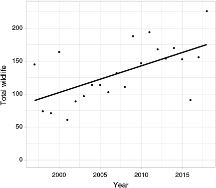
Over the past 20 years, road maintenance clean-up crews have reported 2385 animal carcasses along Highway 3 resulting from AVCs. We found a significant increasing trend in annual AVCs in our study area from 1997 to 2018 (r2 = 0.36, P = 0.003; Fig. 3). The species reported in the AVC data included white tailed deer, mule deer, elk, moose, bighorn sheep, black bear and grizzly bear.
|
|
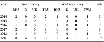
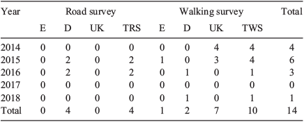
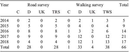
The number of animal carcasses detected per year at each MES from road and walking surveys are shown in Tables 1–3. Animal carcasses recorded at MES during walking surveys include deer species, elk, cougar and bighorn sheep. Deer species were most common at Rock Creek and Iron Ridge, whereas bighorn sheep were most common at Emerald Lake. To account for the difference in walking survey sampling effort, we calculated the number of carcasses per MES standardised to walking survey effort (Table 4).
|
|
|

|
We determined a correction factor applied to road-surveyed carcass data for large mammals of 2.8 ± 0.74 (Table 4), so as to account for injury bias in traditional road survey datasets. There was variability among the MESs, with a correction factor of 2.4 at Rock Creek, 3.5 at Iron Ridge and 2.1 at Emerald Lake.
Cost–benefit of road mitigation with a correction factor
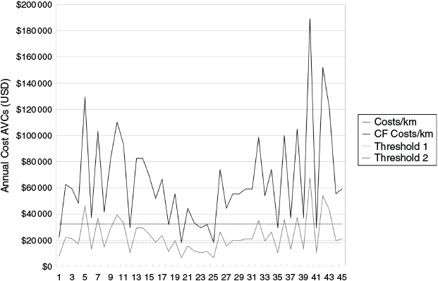
The total annual cost of AVCs for the 45 km stretch of Highway 3 from the Alberta–British Columbia border to Lundbreck, Alberta, is US$1 045 417. With the calculated correction factor of 2.8, the annual cost increases to US$2 927 168. To better understand the implications for cost–benefit of road mitigation, we compared the total cost of collisions per 1 km with and without the correction factor applied (Table 5). Without the correction factor, 10 km of road (representing 22% of the study area) exceed the cost–benefit threshold for underpass, jump-outs and fencing on the basis of US$32 457 annual cost (7% discounted rate) associated with the mitigation (Fig. 4). With the correction factor applied, 36 km of road (representing 80% of the study area) exceeded the cost–benefit threshold for mitigation of an underpass, jump-outs and fencing.

|
In addition, the correction factor increased the number of neighbouring road sections where road mitigation would be cost-effective. Without the correction factor, two road mitigation neighbourhoods (defined as a grouping of adjacent road sections where road mitigation is cost-effective) were identified. With the correction factor, six road mitigation neighbourhoods were identified, ranging from 4 to 10 km long (Table 5, represented in dark grey).
Discussion
The Canadian road network supports continually increasing traffic volumes. Traffic on Canada’s National Highway System grew by 18% from 2005 to 2018, increasing the risk of AVCs (Transport Canada 2018). Along Highway 3 in Alberta, our results show a statistically significant increase in the number of AVCs over 20 years. Increasing AVCs are a concern to both motorist safety and maintaining healthy wildlife populations in this important landscape (Clevenger et al. 2010; Weaver 2013). In rural Alberta, 50% of collisions are due to AVCs, costing the province an estimated C$280 million per year (Alberta Transportation 2017). Concern for motorist safety and the high cost of AVCs create strong socioeconomic incentives for transportation agencies to implement road mitigation strategies. Decision-making associated with road mitigation measures tends to be driven by identifying road sections with AVC clusters and where cost–benefit assessments justify road mitigation measures. Providing a more accurate assessment of the number of AVCs equips transportation agencies to implement effective road mitigation.
Our study demonstrated that AVCs involving large mammals are underestimated; more animal carcasses were reported during walking surveys off the road than were reported during road surveys. These animal carcasses represent error sources in traditional AVC datasets generated by road surveys, because of injury bias. In our region of the Rocky Mountains, we suggest that a correction factor of 2.8 can be applied to road survey datasets to account for undetected road-kills. Factors affecting sources of error are not likely to be consistent across sites, habitat types and/or species guilds and should, therefore, be assessed by region and species assemblage (Slater 2002). Our correction factor will not be appropriate for smaller species that are harder to detect and whose carcasses persist for shorter periods of time, for example, small mammals, amphibians and reptiles (Santos et al. 2011; Degregorio et al. 2011; Santos et al. 2016). We recommend that in regions with different habitat types and species guilds, similar studies be conducted to determine a correction factor for AVC data collection and cost–benefit analyses.
Although our correction factor is specific for our landscape, our general result that traditional roadside AVC counts are underestimates applies to other landscapes and species assemblages. Improving methods should improve existing systems to account for animal carcasses observed off the road right of way. Alternatively, in areas where animal carcass visibility from the road surface is limited, the survey methodology presented here could improve estimate accuracy.
We found some variability among the MESs in our study area, ranging from a correction factor of 2.1 to 3.5. This highlights the importance of including multiple study sites in correction factor assessments. All three sites offer limited visibility to the surrounding landscape from the road surface, occur in similar vegetation communities and have similar traffic volumes and speed limits. The variability could be partially attributed to differences in species diversity at each MES; although all three sites reported deer AVCs, bighorn sheep occur only at the Emerald Lake MES and elk occur most commonly at Iron Ridge MES. Although there is some species diversity among the MESs, our study was not able to assess species responses to AVC injury bias because of the low numbers of large mammal species (other than deer) reported during the study at all three sites.
Our analysis was dependent on detecting animal carcasses through systematic monitoring by using two different survey types, namely, walking and driving. Possible detection errors include carcass persistence rate (how long carcasses remain visible), overlooked carcasses, removal by predators and/or difference in survey protocols (Santos et al. 2011, 2016). In the present study, the two survey methodologies (road vs walking surveys) differed in temporal resolution; road surveys were undertaken twice daily, whereas walking surveys occurred at ~7-day intervals on the basis of assumed differences in carcass detection probabilities. Carcass detection while driving at 110 km h−1 along a highway was estimated to be lower than at walking speed; thus, walking surveys were less frequent.
Carcass persistence is dependent on body size and habitat type or vegetative cover. A study by Santos et al. (2011) suggested a 2-day interval between surveys on the basis of large-mammal carcass persistence on road rights-of-way. Our road surveys took place twice daily and, therefore, occurred more frequently than recommended, which further improves our confidence that carcasses on the road were accounted for. A week between walking surveys was deemed a minimum survey period appropriate on the basis of expert knowledge and deterioration rates that would enable species identification. However, many of the large carcasses reported by citizen scientists were no longer identifiable and were, therefore, recorded as an unknown species. In addition, the expected number of walking surveys did not occur because of inclement conditions such as wildfires and snow events. To address the concern that walking surveys occurred less frequently than recommended, we normalised walking survey data to the expected number of surveys across the three MESs.
In addition, predators occur at all three sites, including cougar, coyote, wolf, black bear and grizzly bear. All will scavenge road-killed animal carcasses. It is possible that the presence of predators may have resulted in an underestimate of animal carcasses during walking surveys. Our method is not able to account for this error, nor cases where injured animals had moved further from the roadway than our walking survey was designed to detect. Given these limitations, and the small area covered during walking surveys, we believe our correction factor is a conservative estimate of injury bias caused by AVCs.
Our results demonstrated how an injury-bias correction factor can affect cost–benefit models for road mitigation. Once the correction factor was applied, cost–benefit analysis suggested that 21 additional kilometres of road in our study area would qualify for road mitigation, including underpasses, jump-puts and fencing. Such road mitigation measures have proven to be effective in reducing AVCs, improving both motorist safety and animal survival, while enabling animal movement across roads (Huijser et al. 2008; Rytwinski et al. 2016).
In addition, the correction factor identified six road mitigation neighbourhoods, ranging in length from 4 to 10 km. A road mitigation neighbourhood represents longer stretches of highway where it is cost-effective to mitigate, and including longer road sections enables a more comprehensive road mitigation system to be designed. For example, long sections justify a series of crossing structures linked by fencing, further reducing the risk to motorists and wildlife and offering more opportunities for animal movement across the highway. A larger series of mitigations has cost efficiencies compared with single or multiple, isolated interventions. Without application of the correction factor, road mitigation measures along Highway 3 would remain focussed on few, isolated structures with wing fencing and have less overall impact on motorist and wildlife safety.
Conflicts of interest
The authors declare no conflicts of interest.
Acknowledgements
The authors thank citizen scientists who collected data over the 5-year period, Elizabeth Anderson, Monica Bartha, Emilie Brien, Chris Clarke, Cindy Crane, Shirley Enzol, Gary Enzol, Travis Huss, Tracey Kaisner, Barbara Koch, Victor Koch, Glenda Newsted, Loretta Schaufele, Gerry Smith, Dorthy Smith, Chris Weickert, Sue Weickert, Nelson White, and Kat Williams. The authors also thank Ken Sanderson from Miistakis Institute who built the smartphone application to support data collection. Animal carcass data were collected by Highway Maintenance Contractors, Volker Stevin, and we thank Chester Markowski and the staff at Coleman maintenance shop for keeping accurate records. This research was generously funded by the Wilburforce Foundation, the Woodcock Foundation, The Calgary Foundation and TD Friends of the Environment.
References
Alberta Sustainable Development (2008). Profile of the South Saskatchewan Region. Edmonton, AB, Canada. Available at https://open.alberta.ca/dataset/5cbbb985-596d-44d3-a55d-efa3bd059c92/resource/65eafbce-966b-4fa6-88de-7fe6b124f1d3/download/profile-of-the-south-saskatchewan-region-2009-11.pdf [verified 24 January 2019].Alberta Transportation (2017). Alberta Wildlife Watch Program. Edmonton, AB, Canada. Available at https://open.alberta.ca/dataset/7c852b82-ecd3-4701-8d84-0b5addbe54ce/resource/d986571a-22bb-41ab-9630-cd4fa9c8cb7b/download/albertawildlifewatchprogramplan.pdf [verified 24 January 2019].
Ang, J. Y., Gabbe, B., Cameron, P., and Beck, B. (2019). Animal–vehicle collisions in Victoria, Australia: an under-recognised cause of road traffic crashes. Emergency Medicine Australasia 31, 851–855.
| Animal–vehicle collisions in Victoria, Australia: an under-recognised cause of road traffic crashes.Crossref | GoogleScholarGoogle Scholar | 31361079PubMed |
Apps, C. (1997). Identification of grizzly bear linkage zones along the Highway 3 corridor of southeast British Columbia and southwest Alberta, British Columbia, Ministry of Environment, Lands and Parks, Victoria, British Columbia, Canada.
Apps, C., Weaver, J., Paquet, P., Bateman, B., and McLellan., B. (2007). Carnivores in the southern Canadian Rockies: core areas and connectivity across the Crowsnest Highway. Wildlife Conservation Society Canada Conservation Rept. 3. Toronto, Ontario, Canada.
Ascensão, F., Kindel, A., Teixeira, F. Z., Barrientos, R., D’Amico, M., Borda-de-Água, L., and Pereira, H. M. (2019). Beware that the lack of wildlife mortality records can mask a serious impact of linear infrastructures. Global Ecology and Conservation 19, .
| Beware that the lack of wildlife mortality records can mask a serious impact of linear infrastructures.Crossref | GoogleScholarGoogle Scholar |
Chetkiewicz, C. B. (2008). Conservation corridors for carnivores: integrating pattern and process in the Canadian Rocky Mountains. University of Alberta, Edmonton, Alberta. Available at https://central.bac-lac.gc.ca/.item?id=NR46297&op=pdf&app=Library&oclc_number=694678247 [verified 5 January 2019].
Chetkiewicz, C. B., and Boyce, M. (2009). Use of resource selection functions to identify conservation corridors. Journal of Applied Ecology 46, 1036–1047.
| Use of resource selection functions to identify conservation corridors.Crossref | GoogleScholarGoogle Scholar |
Clevenger, A. P., Apps, C., Lee, T., Quinn, M., Paton, D., Poulton, D., and Ament, R. (2010). Transportation mitigation for wildlife and connectivity in the Crown of the Continent Ecosystem. Available at https://www.rockies.ca/crossroads/files/H3 Final Report 0610_FINAL SHORT VERSION W CVR.pdf [verified 30 April 2018].
Clevenger, A. P., Barrueto, M., Gunson, K. E., Caryl, F. M., and Ford, A. T. (2015). Context-dependent effects on spatial variation in deer-vehicle collisions. Ecosphere 6, 1–20.
| Context-dependent effects on spatial variation in deer-vehicle collisions.Crossref | GoogleScholarGoogle Scholar |
Conover, M. R., Pitt, W. C., Kessler, K. K., DuBow, T. J., and Sanborn, W. A. (1995). Review of human injuries, illnesses, and economic losses caused by wildlife in the United States. Wildlife Society Bulletin 23, 407–414.
Degregorio, B. A., Hancock, T. E., Kurz, D. J., and Yue, S. (2011). How quickly are road-killed snakes scavenged? Implications for underestimates of road mortality. Journal of the North Carolina Academy of Science 127, 184–188.
| How quickly are road-killed snakes scavenged? Implications for underestimates of road mortality.Crossref | GoogleScholarGoogle Scholar |
Gagnon, J. W., Dodd, N. L., Sprague, S. C., Ogren, K. S., Loberger, C. D., and Schweinsburg, R. E. (2019). Animal-activated highway crosswalk: long-term impact on elk-vehicle collisions, vehicle speeds, and motorist braking response. Human Dimensions of Wildlife 24, 132–147.
| Animal-activated highway crosswalk: long-term impact on elk-vehicle collisions, vehicle speeds, and motorist braking response.Crossref | GoogleScholarGoogle Scholar |
Groot Bruinderink, G. W. T. A., and Hazebroek, E. (1996). Society for conservation biology ungulate traffic collisions in Europe. Conservation Biology 10, 1059–1067.
| Society for conservation biology ungulate traffic collisions in Europe.Crossref | GoogleScholarGoogle Scholar |
Huijser, M. P., Fuller, J., Wagner, M. E., Hardy, A., and Clevenger, A. P. (2007). Animal–vehicle collision data collection: a synthesis of highway practice. Washington, DC, USA. Available at https://www.researchgate.net/publication/281332340_Animal-Vehicle_Collision_Data_Collection_A_Synthesis_of_Highway_Practice [verified 27 April 2020].
Huijser, M. P., McGowen, P., Fuller, J., Hardy, A., Kociolek, A., Clevenger, A. P., Smith, D., and Ament, R. (2008). Wildlife–Vehicle Collision Reduction Study: Report to US Congress. Washington, DC, USA. Available at https://www.fhwa.dot.gov/publications/research/safety/08034/
Huijser, M. P., Duffield, J. W., Clevenger, A. P., Ament, R. J., and McGowen, P. T. (2009). Cost–benefit analyses of mitigation measures aimed at reducing collisions with large ungulates in the United States and Canada: a decision support tool. Ecology and Society 14, 15.
| Cost–benefit analyses of mitigation measures aimed at reducing collisions with large ungulates in the United States and Canada: a decision support tool.Crossref | GoogleScholarGoogle Scholar |
Langbein, J., Putman, R. J., and Pokorny, B. (2011). Road traffic accidents involving ungulates and available measures for mitigation. In ‘Ungulate Management in Europe: Problems and Practices’. (Eds R. J. Putman, M. Apollonio, and R. Andersen.) pp. 215–259. (Cambridge University Press: Cambridge, UK.)
Lee, T., Quinn, M. S., and Duke, D. (2006). Citizen, science, highways, and wildlife: using a web-based GIS to engage citizens in collecting wildlife information. Ecology and Society 11, 11.
| Citizen, science, highways, and wildlife: using a web-based GIS to engage citizens in collecting wildlife information.Crossref | GoogleScholarGoogle Scholar |
Lenhert, M. A., and Bissonette, J. A. (1998). Effectiveness of highway crosswalk structures at reducing deer–vehicle collisions. Wildlife Society Bulletin 25, 809–818.
Litvaitis, J. A., and Tash, J. P. (2008). An approach toward understanding wildlife–vehicle collisions. Environmental Management 42, 688–697.
| An approach toward understanding wildlife–vehicle collisions.Crossref | GoogleScholarGoogle Scholar | 18427884PubMed |
McKelvey, K. S., Copeland, J. P., Schwartz, M. K., Littell, J. S., Aubry, K. B., Squires, J. R., Parks, S. A., Elsner, M. M., and Mauger, G. S. (2011). Climate change predicted to shift wolverine distributions, connectivity, and dispersal corridors. Ecological Applications 21, 2882–2897.
| Climate change predicted to shift wolverine distributions, connectivity, and dispersal corridors.Crossref | GoogleScholarGoogle Scholar |
Morelle, K., Lehaire, F., and Lejeune, P. (2013). Spatio-temporal patterns of wildlife-vehicle collisions in a region with a high-density road network. Nature Conservation 5, 53–73.
| Spatio-temporal patterns of wildlife-vehicle collisions in a region with a high-density road network.Crossref | GoogleScholarGoogle Scholar |
Polak, T., Rhodes, J. R., Jones, D., and Possingham, H. P. (2014). Optimal planning for mitigating the impacts of roads on wildlife. Journal of Applied Ecology 51, 726–734.
| Optimal planning for mitigating the impacts of roads on wildlife.Crossref | GoogleScholarGoogle Scholar |
Proctor, M. F., Paetkau, D., McLellan, B. N., Stenhouse, G. B., Kendall, K. C., Mace, R. D., Kasworm, W. F., Servheen, C., Lausen, C. L., Gibeau, M. L., Wakkinen, W. L., Haroldson, M. A., Mowat, G., Apps, C. D., Ciarniello, L. M., Barclay, R. M. R., Boyce, M. S., Schwartz, C. C., and Strobeck, C. (2012). Population fragmentation and inter-ecosystem movements of grizzly bears in western Canada and the northern United States. Wildlife Monographs 180, 1–46.
| Population fragmentation and inter-ecosystem movements of grizzly bears in western Canada and the northern United States.Crossref | GoogleScholarGoogle Scholar |
Ramp, D., Caldwell, J., Edwards, K. A., Warton, D., and Croft, D. B. (2005). Modelling of wildlife fatality hotspots along the Snowy Mountain Highway in New South Wales, Australia. Biological Conservation 126, 474–490.
| Modelling of wildlife fatality hotspots along the Snowy Mountain Highway in New South Wales, Australia.Crossref | GoogleScholarGoogle Scholar |
Rosell, C., Fernández-Bou, M., Camps, F., Boronat, C., Navàs, F., Martínez, M., and Sorolla, A. (2013). Animal–Vehicle Collisions: a new cooperative strategy is needed to reduce the conflict. In ‘Proceedings ICOET 2013 International Conference on Ecology and Transportation’, Arizona, USA. Available at https://www.researchgate.net/publication/273758330_Wildlife-vehicle_collisions_in_Spain [verified 27 April 2020].
Rytwinski, T., Soanes, K., Jaeger, J., Fahrig, L., Findlay, C., Houlahan, J., van der Ree, R., and van der Grift, E. (2016). How effective is road mitigation at reducing road-kill? A meta-analysis. PLoS One 11, .
| How effective is road mitigation at reducing road-kill? A meta-analysis.Crossref | GoogleScholarGoogle Scholar | 27870889PubMed |
Sáenz-de-Santa-María, A., and Tellería, J. L. (2015). Wildlife–vehicle collisions in Spain. European Journal of Wildlife Research 61, 399–406.
| Wildlife–vehicle collisions in Spain.Crossref | GoogleScholarGoogle Scholar |
Santos, S. M., Carvalho, F., and Mira, A. (2011). How long do the dead survive on the road? Carcass persistence probability and implications for road-kill monitoring surveys. PLoS One 6, .
| How long do the dead survive on the road? Carcass persistence probability and implications for road-kill monitoring surveys.Crossref | GoogleScholarGoogle Scholar | 21980437PubMed |
Santos, R. A. L., Santos, S. M., Santos-Reis, M., De Figueiredo, A. P., Bager, A., Aguiar, L. M. S., and Ascensão, F. (2016). Carcass persistence and detectability: reducing the uncertainty surrounding wildlife–vehicle collision surveys. PLoS One 11, e0165608.
| Carcass persistence and detectability: reducing the uncertainty surrounding wildlife–vehicle collision surveys.Crossref | GoogleScholarGoogle Scholar |
Santos, R. A. L., Mota-Ferreira, M., Aguiar, L. M. S., and Ascensão, F. (2018). Predicting wildlife road-crossing probability from roadkill data using occupancy-detection models. The Science of the Total Environment 642, 629–637.
| Predicting wildlife road-crossing probability from roadkill data using occupancy-detection models.Crossref | GoogleScholarGoogle Scholar |
Slater, F. M. (2002). An assessment of wildlife road casualties: the potential discrepancy between numbers counted and numbers killed. Web Ecology 3, 33–42.
| An assessment of wildlife road casualties: the potential discrepancy between numbers counted and numbers killed.Crossref | GoogleScholarGoogle Scholar |
Snow, N. P., Porter, W. F., and Williams, D. M. (2015). Underreporting of wildlife–vehicle collisions does not hinder predictive models for large ungulates. Biological Conservation 181, 44–53.
| Underreporting of wildlife–vehicle collisions does not hinder predictive models for large ungulates.Crossref | GoogleScholarGoogle Scholar |
Transport Canada (2018). ‘Transportation in Canada 2018. Transport Canada, Ottawa, Ontario, Canada.’ pp. 1–155. https://doi.org/T1–23A/2011E-PDF.
van der Ree, R., Smith, D., and Grilo, C. (2015). ‘Handbook of Road Ecology.’ (John Wiley & Sons: New York, NY, USA.)
Vanlaar, W. G. M., Gunson, K., Brown, S. W., and Robertson, R. D. (2012). Wildlife vehicle collisions in Canada: a review of the literature and a compendium of existing data sources. Ottawa, ON, Canada. Available at https://tirf.ca/wp-content/uploads/2017/01/WildlifeVehicle_Collision_Deliverable1_Eng_6.pdf [verified 6 March 2018].
Van Manen, F. T., McCollister, M. F., Nicholson, J. M., Thompson, L. M., Kindall, J. L., and Jones, M. D. (2012). Short-term impacts of a 4-lane highway on American black bears in eastern North Carolina. Wildlife Monographs , .
| Short-term impacts of a 4-lane highway on American black bears in eastern North Carolina.Crossref | GoogleScholarGoogle Scholar |
Ward, G., Gunson, K., Brown, S., and Robertson, R. (2011). Creating a wildlife–vehicle collision clearinghouse in Canada. Ottawa, Ontario, Canada. Available at https://tirf.ca/wp-content/uploads/2017/01/WildlifeVehicle_Collision_Deliverable2_Eng_5.pdf [verified 27 April 2020].
Weaver, J. (2013). Safe Havens, Safe Passages for Vulnerable Fish and Wildlife. Critical Landscapes in the Southern Canadian Rockies, British Columbia and Montana. Available at https://programs.wcs.org/beta/Resources/Publications/Publications-Search-II/ctl/view/mid/13340/pubid/DMX3102200000.aspx [verified 16 October 2019].
Winton, S. A., Taylor, R., Bishop, C. A., and Larsen, K. W. (2018). Estimating actual versus detected road mortality rates for a northern viper. Global Ecology and Conservation 16, e00476.
| Estimating actual versus detected road mortality rates for a northern viper.Crossref | GoogleScholarGoogle Scholar |