

Bridging knowledge gaps on the role of spatial planning in wildfire risk reduction: insights from Portugal
Fantina Tedim A * , André Samora-Arvela A , José Aranha B , Catarina Coimbra C , Fernando Correia A and Diogo M. Pinto A
A Centre of Studies in Geography and Spatial Planning (CEGOT), Faculty of Arts and Humanities, University of Porto, 4150-564 Porto, Portugal.
B Centre for the Research and Technology of Agroenvironmental and Biological Sciences (CITAB), University of Trás-os-Montes and Alto Douro, 5001-801 Vila Real, Portugal.
C Guarda Municipal Council, Serviço Florestal e Desenvolvimento Rural, Praça do Município 5A, 6300-854 Guarda, Portugal.
International Journal of Wildland Fire 32(3) 403-416 https://doi.org/10.1071/WF22131
Submitted: 1 July 2022 Accepted: 10 February 2023 Published: 2 March 2023
© 2023 The Author(s) (or their employer(s)). Published by CSIRO Publishing on behalf of IAWF. This is an open access article distributed under the Creative Commons Attribution-NonCommercial-NoDerivatives 4.0 International License (CC BY-NC-ND)
Abstract
Background: This paper identifies the weaknesses of the Portuguese approach to promote wildfire risk reduction through spatial planning.
Aims: This paper contributes to bridging a critical gap in knowledge on the role of spatial planning in the reduction of wildfire hazard, given that the characteristics of fire hazard are distinctive from other natural hazards.
Methods: Firstly, we used an online questionnaire answered by 175 municipalities of Portugal in order to examine local technicians’ experience in applying spatial planning legislation and wildfire management policies. In a second step, we collected data from a Delphi survey with 27 experts with the aim of confirming or repudiating the importance of each need for integration between spatial planning and rural fire management indicated by the replies of the 175 municipalities.
Key results, conclusions, and implications: One of the main identified weaknesses relates to the integration of the National Hazard Map in the Constraints Map of the Master Plans, considering the high inter-annual variability of fire hazard and the long-term definition of the municipal spatial planning framework.
Keywords: communities, hazard index, planning, policies, risk reduction, spatial planning, threats, wildfire.
Introduction
Wildfire losses are increasing in many parts of the world as a consequence of urban sprawl, i.e. ‘the rapid expansion of the geographic extent of cities and towns often characterised by low-density housing’ (Rafferty 2023), the characteristics of the wildland–urban interface and the occurrence of extreme wildfires, whose intensity and frequency are expected to increase owing to climate change (Keeley and Syphard 2016). As these events overwhelm fire suppression capabilities, a stronger focus on prevention and mitigation is required (Tedim et al. 2018, 2020).
Several factors contribute to reduce building losses such as an effective defensible space, landscape-scale factors including housing density and distance to major roads, building construction materials, like the standards for home siding, roof covering, door and window materials, and type of occupation (e.g. permanent house, occasional house, rented house) (Srivastava and Laurian 2006; CA.GOV 2010; Syphard et al. 2014, 2017; Syphard and Keeley 2019; Almeida et al. 2021; Samora-Arvela et al. 2023).
Spatial planning and development regulations are recognised as instruments for reducing wildfire hazard and exposure across the wildland–urban interface (Mowery et al. 2019, Mockrin et al. 2020; Gatti and McGee 2021; Gonzalez-Mathiesen et al. 2021). Whereas for other natural hazards (e.g. floods, coastal erosion), there is long experience of using spatial planning to reduce risk, in the wildfire domain remain, there are some critical gaps in knowledge and operationalisation strategies (Mockrin et al. 2020). This is because the traditional static approaches to spatial planning limit the consideration of new understandings about the dynamic temporal and spatial dimensions of wildfires, not accommodating risk reduction context-specific characteristics (Gonzalez-Mathiesen and March 2018; Gonzalez-Mathiesen 2020).
The National Program for Spatial Planning Policy (NPSPP), the main Portuguese instrument for spatial planning at the national scale, that defines the strategies for other programs and plans, approved by Law No. 99/2019, states that the ‘articulation of the master plans with the instruments of forest management, forest defense, and wildfire fighting, is paramount to build a more integrated planning approach that better responds to the challenges of the territories and to safeguard people and goods’ (DGT 2019, p. 243).
The National Plan for Integrated Rural Fire Management (NPIRFM), which emanated from Resolution of the Council of Ministers No. 45-A/2020, established the need to implement the Integrated Management System for Rural Fires (IMSRF), which operating rules were enacted in the Decree Law No. 82/2021. This legal instrument defines the norms and institutional articulation processes in the integrated management of wildfires with two focuses of intervention: protection against wildfires, directed at the safeguarding of people and buildings, and rural fire management, directed at the defence and valorisation of rural territories, considering its protection role by reducing conditions for the occurrence and progression of wildfires. It proposes the integration of wildfire management into spatial planning.
With a higher focus on integrated management, protection of people and property from wildfires, and the development of rural areas, the NPIRFM revoked the previous National Plan for Defence of Forest against Wildfires (NPDFW – Resolution of the Council of Ministers No. 65/2006, 26 May), and its respective system of operation rules (IMSRF) revoked the previous Defence System of Forest Against Wildfires (DSFW), which had been instituted by the Decree Law No. 124/2006, following the NPDFW (Table 1). The previous NPDFW tried to eliminate wildfire risk, while the new NPIRFM advocates a “living with fire” approach. As such, table 1 expresses a comparison between strategic goals of each national plan and the respective wildfire management systems created in its sequence.

|
As such, the previous requirement to draw up Municipal Plans for the Defence of Forests Against Wildfires (MPDFW) of the DSFW was replaced by the requirement of Municipal Programs for the Execution of Integrated Management of Wildfires established by the IMSRF.
In light of the goal of spatial planning and wildfire risk reduction alignment, the IMSRF, as the previous DSFW, stipulates the integration of wildfire hazard maps with five classes (very low, low, medium, high, and very high) in the Constraints Map of the Master Plans, and defines restrictions on building permits within and outside the areas of high and very high fire hazard (Table 2).

|
In this context, both systems proposed the integration of the wildfire hazard map in the Constraints Map of Master Plans, the difference being that the wildfire hazard map in the DSFW was produced by each municipality and focused on the municipal scale, whereas the wildfire hazard map in the IMSRF is developed at the national scale by the Portuguese Institute for the Conservation of Nature and Forests.
Unlike the Master Plans, the MPDFWs and their hazard maps were not legal spatial plans and were not directly binding on individuals as they did not meet the requirements of public advertising and public discussion, essential for the production of effects by any normative act, as enshrined in the respective Paragraph 2 of Article 119 and Paragraph 5 of Article 64 of the Portuguese Republic Constitution (Oliveira 2018), a situation only resolved by the Law No. 76/2017, 17 August.
Owing to this setback, the building permit constraints regarding the DSFW, although more prohibitive, did not have much expression, owing to the lower representation of high and very high hazard areas. With the publication of the National Wildfire Hazard Map in March 2022, the high and very hazardous areas gained, in general terms, greater spatial representation, which led to a greater expression of the building permit constraints of the new IMSRF, despite having created more building permit exceptions than DSFW.
The main instrument for the alignment between spatial planning and wildfire management is the National Wildfire Hazard Map, which becomes one more layer of the Constraints Map of the Master Plan that is the main tool of spatial planning in Portuguese legislation at the local scale. The National Wildfire Hazard Map was produced using a methodology that considers deterministic factors (Verde and Zêzere 2010; Oliveira et al. 2021). The National Wildfire Hazard Map was calculated by multiplying fire probability and susceptibility to wildfires. In this context, while the fire probability is derived from the probabilistic recurrence of fires, slope, elevation, aspect and land cover, susceptibility refers to potential damage, which consists of the product economic value and vulnerability (Verde and Zêzere 2010; Oliveira et al. 2021). The Master Plan informs spatial planning development and allocation of buildings permits. It regulates, at the spatial level, land use/land cover (LULC) change in order to promote sustainable development in a given municipal territory, while its Constraints Map shows restricted areas that limit desirable development, safeguarding the biophysical and cultural character of the territory, as well as avoiding the occupation of areas with the highest hazard index values.
This paper contributes to identifying challenges, strengths and potential impacts of the integration of the National Wildfire Hazard Map into the Master Plans.
The overall research question is: what are the benefits and disadvantages of the National Hazard Map integration in the Constraints Map of the Master Plan? This paper is organised as follows: data and methos’ section summarises the mixed–methods approach used to collect and analyse data; results’ section identifies the difficulties that local governments face in the implementation of the new legislation, namely in the integration of the wildfire hazard map into spatial planning; discussion’s section debates about the the alignment of spatial planning and wildfire risk reduction, the current limitations of the current National Wildfire Hazard Map, the potential impact of the current IMSRF on rural challenges, and the limitations of the research and its next steps; and finally, the conclusions are provided on the last section.
Data and methods
Review of legislation
In this mixed-methods research, we started by reviewing the most recent legislation documents related to wildfire management and spatial planning published in mainland Portugal.
Data collection and analysis
As a first step, an online survey was sent between April and June of 2022 to 275 municipalities (the municipalities of Lisbon, Porto and São João da Madeira were excluded because they are only urban areas). The questionnaire consisted of two questions: (i) what are the main difficulties you face with the implementation of the IMSRF? (ii) do you agree with the decision to integrate the National Wildfire Hazard Map in the Constraints Map of the spatial plans? Please justify your reply.
The response rate was 64%. This exceeds the necessary minimum sample size (161 replies for a confidence level of 95% and a margin of error of 5%), using Kish (1995) and Laureano (2013) equations, for extrapolating conclusions from the results.
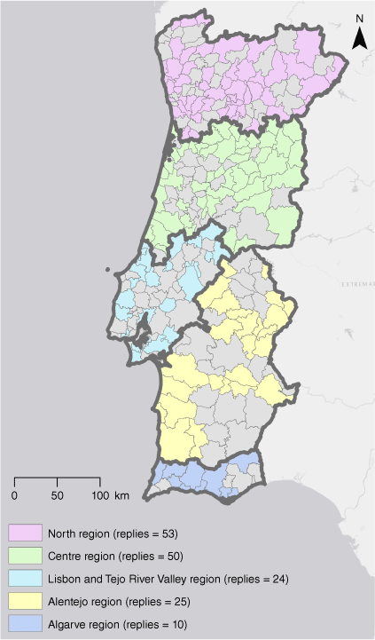
The 175 municipality responses were organised by five territorial regions within the IMSRF governance structure: North (with 53 replies; 62% of the region’s municipalities), Centre (with 50 replies; 73% of the region’s municipalities), Lisbon and Tejo River Valley (with 24 replies; 44% of the region’s municipalities), Alentejo (with 25 replies: 53% of the region’s municipalities) and Algarve (with 10 replies; 63% of region’s municipalities) (Fig. 1). Thirteen municipalities chose to remain anonymous.
|
The data collected was analysed in NVivo software (QSR, 2022), version 1.6.1 (1137). Coding in NVivo enabled the categorisation of the responses to the survey’s open-ended questions and consequently made it possible to count the frequency of each response category.
In a second step, a workshop was held at Guarda Municipal Council on 3 June 2022, where a Delphi questionnaire was applied to 27 stakeholders with practice in spatial planning and wildfire management in order to determine the importance of the main categories emanating from the previous step. The difficulties identified and the justifications presented for accepting or rejecting the inclusion of the National Wildfire Hazard Map in the Master Plan Constraints Map in the national survey were presented and evaluated by the panel of the 27 experts, who chose 15 as the most important. Subsequently, the same panel was invited to rank the relative importance of each one through a one-round real-time Delphi survey supported by a 5-point Likert scale (1 – completely disagree, 2 – disagree, 3 – fairly agree, 4 – agree, 5 – completely agree).
Procedures for measuring consensus and agreement vary widely, so there are several criteria available to determine the convergence of opinion among Delphi participants (Rayens and Hahn 2000; von der Gracht 2012; Beiderbeck et al. 2021). In the present research, the interquartile range (IQR) was used as a consensus criterion, where low values are an indicator of consensus ([0–1]), values of ]1–2[ indicate average consensus, and [2–3] refer to low consensus) (Hahn and Rayens 1999; von der Gracht 2012). According to Rayens and Hahn (2000), a null IQR range indicates complete consensus. The IQR of Delphi responses was calculated in Statistical Package for the Social Sciences 26 (IBM 2022). It was also decided to use the arithmetic mean (Mean) as an agreement criterion. In this sense, an arithmetic mean value above 3.5 (mainly integrating answers 4 – agree, and 5 – completely agree) expresses a tendency to agreement, while an average value lower than 2.5 (mainly integrating answers 1 – completely disagree, and 2 – disagree) reflects a discordant trend. The third criterion used was the percentage of concordant answers (answers 4 – agree, and 5 – completely agree) (Level of Agreement), which is also an agreement criterion that helps analysis of the response trend.
For analysis purposes, the statements that had an arithmetic mean above 3.5 and a level of agreement above 51% are presented in the results.
Results
Main difficulties faced by the municipalities with the implementation of the IMSRF
Results from the online survey
The forestry technicians that responded to the online survey identified several difficulties regarding the integration of the National Wildfire Hazard Map into the Constraints Map of the Master Plans (Table 3).

|
The main difficulties are:
‘New hazard map does not correspond to the existing reality in the territory’ due to spatial resolution, and it is not based on the Master Plan’s urban spaces; the redundancy of the previous hazard maps, among others aspects, were mentioned by 17% of the municipalities. The greatest worries are from municipalities of the Centre region (22% of replies) and North region (19% of replies) (Supplementary Table S1), which have ~50% of their territory in high and very high hazard classes, but also Alentejo (16% replies), where 56% of the surface presents low or no wildfire hazard.
‘LULC map (COS 2018: DGT 2018) does not reflect the existing reality at the local level’, mentioned by 1% of the municipalities. It is a main worry from the Algarve region (10% of replies);
‘Obstacles to cultural and sporting activities’, as articles 67 and 68 of the IMSRF establish the prohibition of many activities in high and very high hazard areas and on days with high Fire Weather Index. It was mentioned by 1% of the municipalities. This is a worry of many municipalities in the Centre region (4% of replies);
‘Difficulties in surveying and mapping burned areas’ was mentioned by 1% of the municipalities. It is a worry of Alentejo municipalities (4% of replies);
‘Confusion between the concept of hazard (structural) and Fire Weather Index (daily)’, mentioned by 1% of the municipalities. It was stated by 4% of the municipalities in the Centre region.
‘Difficulty in understanding the criteria for defining hazardous areas’ was mentioned by 2% of the municipalities from the Centre region;
‘The execution of the fuel management strips has contributed to colossal forest destruction’ was mentioned in the North region (2% of replies) (1% of national replies);
‘The current dimension of the defensible space is not justified, as there is no gain in defence beyond 30 m’ was mentioned by 1% of the municipalities of the North region (2% of North replies).
Consensus of the Delphi panel
Subsequently, the robustness of the consensus in the Delphi survey responses (n = 27 experts) regarding the difficulties and needs for the integration of the hazard map in the Constraints Map of Master Plan was analysed. Those that generated a strong consensus were ‘hazard map does not correspond to the existing reality in the territory (spatial resolution; not based on the Master Plan’s urban spaces; redundancy of the previous hazard maps, among others)’ (mean = 4.41; IQR = 1; level of agreement = 85%), ‘LULC map (COS 2018) does not reflect the existing reality at the local level’ (mean = 4.11; IQR = 1; level of agreement = 85%); ‘confusion between the concept of hazard (structural) and fire weather risk (daily)’ (mean = 3.93; IQR = 1; level of agreement responses = 78%); and ‘difficulty in understanding the criteria for defining hazardous areas’ (mean = 4.37; IQR = 1; level of agreement = 89%) (Table 4).

|
Agreement with the decision to integrate the National Wildfire Hazard Map in the Constraints Map of the Master Plans
Results from the online survey
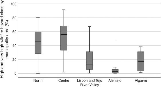
Regarding the integration of the National Wildfire Hazard Map in the Constraints Map of Master Plan, most municipalities agreed with their integration (74%) (Table 5). Within the regions, the representation of high and very high wildfire hazard areas in each region is shown in next figure (Fig. 2).
Lisbon and Tejo River Valley respondent municipalities agree with the integration (96% of region’s replies, where high and very high hazardrepresent 24% of the territory);
Alentejo respondent municipalities agree with the integration (92% of region’s replies, where high and very high hazard represent 5% of the territory);
North region respondent municipalities agree with the integration (79% of region’s replies, where high and very high hazard represent 49% of the territory);
Centre region respondent municipalities agree with the integration (74% of region’s replies, where high and very high hazard represent 51% of the territory);
Algarve region respondent municipalities agree with the integration (60% of region’s replies, where high and very high hazard represent 34% of the territory).

|
|
However, both those who agree and those who disagree presented suggestions for improvement on this subject.
The concordant responses were categorised into decision making, hazard map methodology and expected impacts.
Regarding decision making, the concordant respondents stated that ‘the integration of the hazard map facilitates decision making regarding the licensing of construction and expansion of buildings in rural areas depending on the hazard’ (21% of national replies; 33% of Lisbon and Tejo River Valley; 24% of Alentejo region replies; 21% of North region replies; 20% of Algarve region replies; 14% of Centre region replies).
In addition, ‘the integration of the hazard map in the Constraints Map of the Master Plan is necessary in order to be binding for individuals’ (3% of national replies; 4% of North region replies; 4% of Centre region replies; 4% of Alentejo region replies).
Analysing the hazard map methodology, one of its positive aspects is ‘the criteria, at a national level, for the development of this cartography, leaving no room for discrepancies’ (3% of national replies; 8% of Lisbon and Tejo River Valley replies; 2% of North region replies). Nevertheless, there are municipalities that established some conditions like ‘the methodology for executing the hazard map should be reviewed and should be dynamic’ (2% of national replies; 6% of North region replies), ‘the artificialised territories in the LULC map (COS 2018) do not correspond to the urban spaces of the Master Plan, which makes building permit licensing difficult’ (1% of national replies; 10% of Algarve region replies; 2% of Centre region replies), and that the ‘hazard map must be integrated into the Constraints Map of Master Plan only if it is prepared by the municipality’ (1% of national replies; 2% of North region replies).
About the expected impacts, the concordant respondents acknowledge that ‘the structural hazard map leads to major restrictions’ (2% of national replies; 4% of Centre region replies), ‘the hazard map must not lead to the prohibition of occupation of rural areas, increasing their vulnerability, abandonment, and inherently, increasing hazardousness’ (1% of national replies; 10% of Algarve region replies), and ‘hazard index encourages the management of rural areas insofar as the less dangerous nature of the plots will increase their financial value’ (1% of national replies; 4% of Lisbon and Tejo River Valley replies).
Discordant respondents, however, presented answers that were grouped into four themes: expected impacts, mismatches in the planning framework, legal framework and hazard map methodology.
For these respondents, the main expected impacts were related to major restrictions determined through the hazard map (5% of national replies; 10% of Algarve region replies; 6% of North region replies; 6% of Centre region replies).
Within mismatches in the planning framework, municipalities stated that the ‘hazard index, due to its dynamic nature, becomes impracticable to be transposed into the Master Plan’s Constraints Map’ (3% of national replies), ‘there is an incompatibility between the rigidity of the spatial plans and the dynamics of transformation of the territory’ (1% of national replies; 2% of Centre region replies), and that ‘the hazard map must maintain its independent character from the spatial plans, supporting forestry planning and rural fire management’ (1% of national replies; 10% of Algarve region replies).
Among legal aspects, municipalities stated that the hazard map binds individuals without having been published for public consultation’ (2% of national replies; 10% of Algarve region replies; 4% of Centre region replies).
Regarding to hazard map methodology, ‘the hazard mapping should be carried out by the municipalities’ (1% of national replies; 2% of North region replies) and ‘the hazard map was created by identifying spaces with high fire recurrence and from a standpoint of definition of defence areas, so it cannot be used as a building constraint’ (1% of national replies; 2% of North region replies).
It is not surprising that the highest participation rate and greatest concern with hazard-related restrictions was from municipalities in the North and Centre regions, as these are the regions that have ~50% of their territory in high and very high hazard index areas (Fig. 2, Table 6).

|
The greatest agreement with the integration of the National Wildfire Hazard Map in the Constraints Map of Master Plans can be seen in municipalities in the southern regions of the country (Lisbon and Tejo River Valley, Alentejo and Algarve), while municipalities further north (North and Centre region) are more resistant.
Consensus of the Delphi panel
Regarding the justification of the concordant and discordant answers, and the suggestions for improvement, there is consensus in (Table 7):
‘the methodology for executing the hazard map should be reviewed and should be dynamic’ (mean = 3.56; IQR = 1; level of agreement = 89%);
‘the hazard map binds individuals without having been published for public consultation’ (mean = 4.15; IQR = 1; level of agreement = 77%);
‘the hazard mapping should be carried out by the municipalities’ (mean = 4.00; IQR = 2; level of agreement = 69%).

|
Below the arithmetic mean of 4, there is consensus in relation to:
‘the National Wildfire Hazard Map leads to major restrictions’ (mean = 3.96; IQR = 0; level of agreement = 81%); ‘the integration of the hazard map in Constraints Map of Master Plan is necessary in order to be binding for individuals’ (mean = 3.89; IQR = 2; level of agreement = 63%);
‘the hazard map must not lead to the prohibition of occupation of rural areas, increasing their vulnerability, abandonment and inherently increasing hazardousness’ (mean = 3.85; IQR = 2; level of agreement = 63%);
‘there is an incompatibility between the rigidity of the Spatial Plans and the dynamics of transformation of the territory’ (mean = 3.81; IQR = 2; level of agreement = 62%);
‘the hazard map must be integrated into the Constraints Map of Master Plan only if it is prepared by the municipality’ (mean = 3.70; IQR = 2; level of agreement = 67%);
‘the hazard map was created by identifying spaces with high fire recurrence and from a standpoint of definition of defence areas, so it cannot be used as a building constraint’ (mean = 3.69; IQR = 2; level of agreement = 54%);
‘the integration of the hazard map facilitates decision making regarding the licensing of construction and expansion of buildings in rural areas depending on the hazard’ (mean = 3.59; IQR = 2; level of agreement = 63%);
‘the artificialized territories in the LULC map (COS 2018) do not correspond to the urban spaces of the Master Plan, which makes building permit licensing difficult’ (mean = 3.56; IQR = 1; level of agreement = 63%);
‘the hazard index, owing to its dynamic nature, becomes impracticable to be transposed into the Master Plan’s Constraints Map’ (mean = 3.52; IQR = 1; level of agreement = 52%).
Discussion
The alignment of spatial planning and wildfire risk reduction
The current spatial planning framework in Portugal is hierarchical and very normative at the municipal level and should try to move from a strict land-use zoning approach, namely with a consistent development strategy for a given territory (Ferrão 2011). In this sense, Cavaco et al. (2022) advocate a soft planning approach, supported by principles of strategic planning, policy integration, collaborative governance and long-term vision, proposing the consideration of ‘alternatives scales, rather those of statutory powers, where soft spaces feature the creation of new levels of geographical resolution to address specific territorial phenomena in a place-based and tailor-made view’ (Cavaco et al. 2022, p. 15).
Although the alignment of spatial planning and wildfire risk reduction is paramount, it should be supported by an approach that accommodates the different landscape scales, the local context, and the dynamic and temporal dimensions of wildfire risk (Gonzalez-Mathiesen et al. 2021), avoiding static, simplistic and deductive approaches that limit new understandings about the dynamic temporal and spatial dimensions of wildfires and do not take into account risk reduction context-specific characteristics (Gonzalez-Mathiesen and March 2018; Gonzalez-Mathiesen 2020).
In the current context of aligning wildfire fire risk reduction with spatial planning, the integration of the National Wildfire Hazard Map in the Constraints Map of spatial plans crystallises the spatialisation of the areas with the greatest wildfire hazard, given the trend that master plans are only revised after 10, 20 or more years. Thus, it will fail to assume the impact of fuel management initiatives and the dynamics of LULC change on the hazard index reduction.
The limitations of the current National Wildfire Hazard Map
The National Wildfire Hazard Map methodology considers as predisposing factors slope, elevation, aspect and LULC, but there is, for instance, no evidence of the influence of elevation in wildfire occurrence and behaviour (Tedim et al. 2018). The scientific support for the threshold for each class for the independent variables (slope and elevation) is not clearly presented and the spatial resolution of the data inputs is not the appropriate one. In this context, the dependent variable considered is the burnt area. However, burnt area is a rather weak descriptor of wildfire activity, as it is not well correlated either with fire intensity or the heterogeneity of fire severity distribution within fire boundaries (including the existence of unburned patches), or with socio-economic impacts (e.g. Tedim et al. 2014, 2016). The diversity of characteristics exhibited by unburned patches inside a fire perimeter shows that their formation is not tied to static landscape characteristics (e.g. slope, elevation, aspect) but they occur as a result of complex interactions of those factors with the dynamic factors of landscape, mainly local ones (Tedim et al. 2018). Thus, the methodology used is too simplistic and fuel management activities that may be done to reduce wildfire hazard are not going to make any difference in the hazard map and in the planning of suppression strategy. To support wildfire prevention, mitigation and preparedness, wildfire hazard must be considered in a dynamic way (e.g. USDA 2022) and mainly accommodate the factors related to the probability of ignition and those (e.g. fuel moisture, fuel load, types of fuel) affecting fire behaviour (e.g. fire intensity, rate of spread, spotting) (Oom et al. 2022).
Based on the factors mentioned, the National Wildfire Hazard Map displays pixels of 625 m2 (25 × 25 m), which constitute an area polygon in a given hazard class that is too generalistic to support building permit constraints.
Another constraint of the current hazard map is the accuracy of the data used to calculate the slope and LULC. Regarding slope calculation, the National Wildfire Hazard Map was assessed from a Digital Elevation Model (DEM) with a spatial resolution of 25 m (Oliveira et al. 2021). In this context, it is imperative to use a Digital Terrain Model with the maximum possible spatial resolution, so that the areas with the greatest hazard are identified with high accuracy. The accuracy between reality and what is mapped is also a challenge in terms of LULC mapping. On this subject, the LULC map (COS) with a minimum mappable size of 1 ha is commonly used. It is important to consider the disadvantages of COS use at the local scale, depending on its level of accuracy and on the generalisation rules adopted at the time of its preparation. The LULC vectorial map derives from orthophotomap interpretation related to the previous years (up to 2 years before), with a spatial resolution of 20 linear meters and with the mentioned 1 ha in terms of minimum mappable area. From this combination of factors, the COS map, when used, is already out of date.
Another issue is that its spatial resolution is not compatible with identification of isolated housing, scattered housing or road networks. For master plans, the maps should be done at a scale of at least 1/1000, so that human infrastructure is effectively represented (buildings and local road networks). In this context, an opportunity in calculating fire hazard is the use of LULC maps with higher resolution and smaller mappable units that allows greater accuracy to the real LULC, carried out with a constant periodicity that contributes to the expression of the dynamic influence of LULC changes on the fire hazard index of a given territory. LULC is a dynamic factor that can constantly change, such as, for example, through the management of fuel recommended in the IMSRF, and the changes of species in forests, which leads to a reduction in hazard.
In this way, to improve the calculation of fire hazard is an emerging challenge, given the necessary pursuit for permanently updated inputs with greater accuracy. Without taking this into account, integrating fire hazard into the Constraint Map of the Master Plans could fail as a risk reduction strategy owing to the lack of recognition of the dynamic and accurate character of LULC changes.
With regard to the fire recurrence factor, it should be noted that the high frequency of fires leads to less fuel accumulation, which tends to generate less intense fires. When fires are infrequent, there is a high accumulation of fuel, which leads to the infrequent occurrence of high-intensity fires.
Regarding the factors currently considered for the calculation of the hazard index, it is important to mention that they do not apply to extreme wildfires, given their intensity and degree of uncertainty (Tedim et al. 2018, 2020). As such, integrating risk reduction in spatial planning is paramount, but the strategy to be carried out must be dynamic and adaptive, without yielding to the temptation of completely eliminating uncertainty and risk, which is impossible and can produce the opposite effect.
The approach adopted in Portugal is still characterised by a traditional static hazard mapping approach, where there are difficulties in adapting the hazard map to local reality, and in understanding the rationale of the criteria for defining hazard classes, the spatial resolution and accuracy of their inputs. The evidence of the results pointed out that most of the municipal technicians are favourable to the integration of the National Wildfire Hazard Map in the Constraints Map of Spatial Plans, but most also identified problems in the current approach. However, the National Wildfire Hazard Map provoked huge opposition from municipalities and was suspended by Decree Law no. 49/2022 of 19 July. The municipalities have different geographical characteristics, socio-economic dynamics, and institutional and political environments that frame the respondents' replies. In addition, the results of the research raise an important question: do the respondents have a common understanding of the wildfire hazard? ‘Scientific knowledge is in continuous evolution, and different approaches can be used. However, the ‘nature’ of fire problem still lacks a common understanding, both ecologically and socially. The increasing production of wildfire scientific knowledge has not been accompanied by a high impact on the ground for people, society, and the environment and has not improved the current wildfire management system’ (Tedim and Leone 2020, p. 11).
Potential impact of the current IMSRF on rural challenges
The municipalities of North and Centre regions show greater resistance to the integration of the National Wildfire Hazard Map in the Constraint Map of Master Plans. This is due to the greater territorial extent of the wildfire high and very high hazard classes in the municipalities of these regions, which end up with greater impact of the building permits associated with wildfire hazard. This resistance is not shared by municipalities in the south of the country (Lisbon and Tejo River Valley, Alentejo, and Algarve), where the wildfire high and very high hazard classes areas are much less expansive.
In this context, the static approach is based on conditioning building construction according to the hazard classes defined in the National Wildfire Hazard Map, thus determined according to the accuracy of the inputs and its regulatory nature. As for the integration of the National Wildfire Hazard Map in the Master Plans, it was discussed that hazard cartography can undergo annual changes, and it makes no sense to integrate it into a constraint map of the Master Plan that is only reviewed every 10 years.
These building permit constraints, based on hazard classes, are very restrictive, which can discourage the investment and the attraction of people to live in rural areas, aggravating the depopulation of rural areas in Portugal (Tedim et al. 2023). With the decreasing number of inhabitants in rural areas, there could be even fewer means for fuel management activities, thus increasing the wildfire hazard (Tedim et al. 2023).
Limitations of the research and next steps
This research had an exploratory purpose. It should be noted that the national survey of the municipal technicians, based on answers to a questionnaire of open-ended questions, was intended to capture the myriad of opinions concerning the alignment between spatial planning policies and the implementation of the new IMSRF. It created a free space for reflection, based on the experience, knowledge and beliefs of each respondent, regardless of the institution where they worked (Tedim and Paton 2012). The advantage of this procedure is that it enabled free expression of opinion and did not guide the possible replies to a limited number of options. In this case, the results could be slightly variable. Therefore, the inputs from the open-ended questions were further validated through expert opinions using the Delphi method. Nevertheless, we consider that more research should be done to guarantee that there is a common understanding of the problem and to identify awareness gaps.
Therefore, the great opportunity for now is that the current methodology of the National Wildfire Hazard Map should be reviewed in order to be more dynamic. Some issues should be improved such as public consultation for this hazard map, which should, according to municipal technicians and experts, be prepared by municipalities and should be assessed with inputs of better resolution. All the instrumental factors defining the National Wildfire Hazard Map led to a greater increase in high and very high hazard areas in the national territory. Although it is considered that the hazard map should be integrated into the constraint map of Master Plans in order to be binding for individuals, the hazard map should not lead to prohibition of the occupation of rural areas, increasing their vulnerability and abandonment, which could also lead to an increase in hazardousness.
There is an incompatibility between the rigidity and slowness of reviewing the Master Plans and the transformation of the territory, not expressing its dynamics of LULC changes on spatial plans, and inherently on the hazard index.
On the one hand, some experts understand that the integration of the hazard map facilitates decisions and the licensing of building construction, but on the other hand, they also consider that the hazard index, owing to its dynamic nature, should not be transposed onto the constraint map of Master Plans.
Considering the long period of validity of the Master Plans and the length of its revision, spatial planning constraints do not cease to be an instrument for safeguarding the abiotic, biotic and cultural suitability of the territory, whose temporal crystallisation of most permissions and restrictions related to other hazards seems to be appropriate.
Conclusions
Responding to the research question, the integration of the National Wildfire Hazard Map is considered a facilitating factor in the licensing process for building permits. However, limitations are recognised that must be overcome. It is proposed to review the methodology taking into account the dynamic nature of wildfire hazard and to assume that municipalities should carry out their hazard mapping, because they know their local reality, in order that the IMSRF does not lead to exaggerated restrictions on the development of municipalities.
The integration of the National Wildfire Hazard Map into the constraints map of the Master Plan represents a challenge, considering the high intra-annual and inter-annual variability of fire hazard, the long-term definition of the municipal development model and the methodology (including variables used and data accuracy) used to assess hazard. The procedure imposed by the current wildfire policy will create building permit constraints that can limit the development of rural areas, the growth of rural agglomerations and the development of productive activities. The main benefit is the simplification of the building licensing process decision, but currently owing to an overwhelmingly strong request from the municipalities, the application of the National Wildfire Hazard Map was suspended.
The current existing static regulation system leads to growing mismatches, and to potential environmental, economic and social losses. The integration of spatial planning and wildfire risk reduction policies should be more comprehensive and dynamic in looking for new models. Multisector approaches that will be able to mobilise approaches in an adaptive regulation system are paramount and, in this sense, the present paper identified the need to look for new models for integrating wildfire risk reduction’s most pressing opportunities to improve hazard map and spatial plans alignment.
Supplementary material
Supplementary material is available online.
Data availability
Data sharing is not applicable as no new data were generated or analysed during this study.
Conflicts of interest
The authors declare no conflict of interest.
Declaration of funding
Fantina Tedim: coordination of the AVODIS’ project – ‘Understanding and building on the social context of rural Portugal to prevent wildfire disasters’ (FCT Ref: PCIF/AGT/0054/2017), financed by national funds through the Foundation for Science and Technology (FCT), Portugal. This research received dissemination support from the Centre of Studies in Geography and Spatial Planning (CEGOT), funded by national funds through FCT under reference UIDB/04084/2020. André Samora-Arvela: research done under the postdoctoral grant of the AVODIS’ project – ‘Understanding and building on the social context of rural Portugal to prevent wildfire disasters’ (FCT Ref: PCIF/AGT/0054/2017), financed by national funds through FCT, Portugal. This research received dissemination support from CEGOT, funded by national funds through FCT under the reference UIDB/04084/2020. José Aranha: not applicable. Catarina Coimbra: not applicable. Fernando Correia: collaboration with the AVODIS’ project – ‘Understanding and building on the social context of rural Portugal to prevent wildfire disasters’ (FCT Ref: PCIF/AGT/0054/2017), financed by national funds through FCT, Portugal. This research received dissemination support from CEGOT, funded by national funds through FCT under reference UIDB/04084/2020. Diogo M. Pinto: master research grant holder of the AVODIS’ project – ‘Understanding and building on the social context of rural Portugal to prevent wildfire disasters’ (FCT Ref: PCIF/AGT/0054/2017), financed by national funds through FCT, Portugal. This research received dissemination support from CEGOT, funded by national funds through FCT under reference UIDB/04084/2020.
Author contributions
Conceptualisation, F. T. and A. S. A.; methodology, F. T. and A. S. A.; formal analysis, F. T. and A. S. A.; investigation, F. T., A. S. A. and C. C.; resources, F. T., A. S. A. and C. C.; data curation, F. T. and A. S. A., writing – original draft preparation, F. T., A. S. A. and C. C.; writing – review and editing, F. T., A. S. A., C. C., J. A., F. C. and D. M. P.; supervision, F. T.; project coordination, F. T. All authors have read and agreed to the published version of the manuscript.
References
Almeida M, Ribeiro L, Modarres M, Viegas DX (2021) Regras para o Edificado e Envolvente nos Territórios Rurais. Projetos AGIF 2021 (P32100231). (ForestWISE: Coimbra, PT) [Portuguese]Beiderbeck D, Frevel N, von der Gracht HA, Schmidt SL, Schweitzer VM (2021) Preparing, conducting, and analyzing Delphi surveys: Cross-disciplinary practices, new directions, and advancements. MethodsX 8, 101401
| Preparing, conducting, and analyzing Delphi surveys: Cross-disciplinary practices, new directions, and advancements.Crossref | GoogleScholarGoogle Scholar |
CA.GOV (2010) California Building Code Chapter 7A. (California Department of Housing and Community Development: Sacramento, USA) Available at https://www.hcd.ca.gov/building-standards/state-housing-law/wildland-urban-interface/docs/2010-part-2-cbc-ch7a.pdf
Cavaco C, Mourato J, Costa JP, Ferrão J (2022) Beyond soft planning: Towards a soft turn in planning theory and practice? Planning Theory 22, 3–26.
| Beyond soft planning: Towards a soft turn in planning theory and practice?Crossref | GoogleScholarGoogle Scholar |
DGT (2018). Carta de Uso e Ocupação do Solo (COS) de 2018 (Directorate-General for the Territory: Lisbon, PT)
DGT (2019). Law No. 99/2019, 5 of September: 1st revision of the National Program for Spatial Planning Policy (NPSPP). Available at https://pnpot.dgterritorio.gov.pt/node/10 [Verified 11 April 2022]
Ferrão J (2011) ‘O Ordenamento do Território como Política Pública.’ (Fundação Calouste Gulbenkian: Lisbon, PT) [Portuguese]
Gatti E, McGee T (2021) ‘Survey of Municipal LULC Planning for Wildfire Risk Mitigation in Alberta.’ (University of Alberta, Department of Earth and Atmospheric Sciences: Edmonton, CA)
Gonzalez-Mathiesen C (2020) Spatial planning to promote settlements’ resilience to bushfires. PhD thesis, University of Melbourne, Vic., Australia.
Gonzalez-Mathiesen C, March A (2018) Establishing design principles for wildfire-resilient urban planning. Planning Practice & Research 33, 97–119.
| Establishing design principles for wildfire-resilient urban planning.Crossref | GoogleScholarGoogle Scholar |
Gonzalez-Mathiesen C, Ruane S, March A (2021) Integrating wildfire risk management and spatial planning – A historical review of two Australian planning systems. International Journal of Disaster Risk Reduction 53, 101984
| Integrating wildfire risk management and spatial planning – A historical review of two Australian planning systems.Crossref | GoogleScholarGoogle Scholar |
Hahn EJ, Rayens MK (1999) Consensus for tobacco policy among former state legislators using the policy Delphi method. Tobacco Control 8, 137–140.
| Consensus for tobacco policy among former state legislators using the policy Delphi method.Crossref | GoogleScholarGoogle Scholar |
IBM (2022) ‘Statistical Package for the Social Sciences 26.’ (International Business Machines Corporation: New York) Available at https://www.ibm.com/support/pages/downloading-ibm-spss-statistics-26
Keeley J, Syphard A (2016) Climate Change and Future Fire Regimes: Examples from California. Geosciences 6, 37
| Climate Change and Future Fire Regimes: Examples from California.Crossref | GoogleScholarGoogle Scholar |
Kish L (1995) ‘Survey Sampling.’ (Wiley Classics Library: New York)
Laureano R (2013) ‘Teste de Hipóteses com o SPSS’, 2nd edn. (Edições Sílabo: Lisbon) [Portuguese]
Mockrin MH, Fishler HK, Stewart SI (2020) After the fire: Perceptions of land use planning to reduce wildfire risk in eight communities across the United States. International Journal of Disaster Risk Reduction 45, 101444
| After the fire: Perceptions of land use planning to reduce wildfire risk in eight communities across the United States.Crossref | GoogleScholarGoogle Scholar |
Mowery M, Read A, Johnston K, Wafaie T (2019) Planning the Wildland–Urban Interface. PAS Report 594. p. 194. (American Planning Association: Chicago, USA). Available at https://www.planning.org/publications/report/9174069/
Oliveira FP (2018) Algumas notas sobre as alterações ao Decreto-Lei no. 124/2006, de 28 de junho operadas pela Lei no. 76/2017, de 17 de agosto que define o Sistema de Defesa da Floresta Contra Incêndios. E-PUBLICA – Revista Eletrónica de Direito Público 4, 26–40. [Portuguese]
Oliveira S, Gonçalves A, Zêzere JL (2021) Reassessing wildfire susceptibility and hazard for mainland Portugal. Science of the Total Environment 762, 143121
| Reassessing wildfire susceptibility and hazard for mainland Portugal.Crossref | GoogleScholarGoogle Scholar |
Oom JFD, De Rigo D, Pfeiffer H, Branco A, Ferrari D, Grecchi R, Artes Vivancos T, Durrant T, Boca R, Maianti P, Liberta G, San-Miguel-Ayanz J (2022) ‘Pan-European wildfire risk assessment.’ (Publications Office of the European Union: Luxembourg, LU)
| Crossref |, JRC130136 [ISBN 978-92-76-55138-6]
QSR (2022) ‘NVivo Release 1.6.1 software’. NVivo Release 1.6.1 software. (QSR International Pty Ltd: Burlington, USA)
Rafferty JP (2023) ‘Definition of Urban Sprawl.’ (Britannica Encyclopædia: Chicago, USA) Available at https://www.britannica.com/topic/urban-sprawl
Rayens K, Hahn J (2000) Building consensus using the policy Delphi method. Policy, Politics, & Nursing Practice 1, 308–315.
| Building consensus using the policy Delphi method.Crossref | GoogleScholarGoogle Scholar |
Samora-Arvela A, Aranha J, Correia F, Pinto DM, Magalhães C, Tedim F (2023) Understanding Building Resistance to Wildfires: A Multi-Factor Approach. Fire 6, 32
| Understanding Building Resistance to Wildfires: A Multi-Factor Approach.Crossref | GoogleScholarGoogle Scholar |
Srivastava R, Laurian L (2006) Natural hazard mitigation in local comprehensive plans: the case of flood, wildfire and drought planning in Arizona. Disaster Prevention and Management 15, 461–483.
| Natural hazard mitigation in local comprehensive plans: the case of flood, wildfire and drought planning in Arizona.Crossref | GoogleScholarGoogle Scholar |
Syphard AD, Keeley JE (2019) Factors Associated with Structure Loss in the 2013–2018 California Wildfires. Fire 2, 49
| Factors Associated with Structure Loss in the 2013–2018 California Wildfires.Crossref | GoogleScholarGoogle Scholar |
Syphard AD, Brennan TJ, Keeley JE (2014) The role of defensible space for residential structure protection during wildfires. International Journal of Wildland Fire 23, 1165–1175.
| The role of defensible space for residential structure protection during wildfires.Crossref | GoogleScholarGoogle Scholar |
Syphard AD, Brennan TJ, Keeley JE (2017) The Importance of Building Construction Materials Relative to Other Factors Affecting Structure Survival during Wildfire. International Journal of Disaster Risk Reduction 21, 140–147.
| The Importance of Building Construction Materials Relative to Other Factors Affecting Structure Survival during Wildfire.Crossref | GoogleScholarGoogle Scholar |
Tedim F, Leone V (2020) The dilemma of wildfire definition: What it reveals and what it implies. Frontiers in Forests and Global Change 3, 553116
| The dilemma of wildfire definition: What it reveals and what it implies.Crossref | GoogleScholarGoogle Scholar |
Tedim F, Paton D (Eds) (2012) ‘A Dimensão Social dos Incêndios Florestais - Para uma Gestão Integrada Sustentável.’ (Estratégias Criativas: Porto) [Portuguese]
Tedim F, Remelgado R, Carvalho S, Martins J (2014) The largest forest fires in Portugal: the constraints of burned area size on the comprehension of fire severity. Journal of Environmental Biology 36, 133–143. Available at https://repositorio-aberto.up.pt/handle/10216/79926
Tedim F, Leone V, Xanthopoulos G (2016) A wildfire risk management concept based on a social-ecological approach in the European Union: Fire Smart Territory. International Journal of Disaster Risk Reduction 18, 138–153.
| A wildfire risk management concept based on a social-ecological approach in the European Union: Fire Smart Territory.Crossref | GoogleScholarGoogle Scholar |
Tedim F, Leone V, Amraoui M, Bouillon C, Coughlan MR, Delogu GM, Fernandes PM, Ferreira C, McCaffrey S, McGee TK, Parente J, Paton D, Pereira MG, Ribeiro LM, Viegas DX, Xanthopoulos G (2018) Defining Extreme Wildfire Events: Difficulties, Challenges, and Impacts. Fire 1, 9
| Defining Extreme Wildfire Events: Difficulties, Challenges, and Impacts.Crossref | GoogleScholarGoogle Scholar |
Tedim F, McCaffrey S, Leone V, Delogu GM, Castelnou M, McGee TK, Aranha J (2020) What can we do differently about the extreme wildfire problem: An overview. In ‘Extreme Wildfire Events and Disasters’. (Eds F Tedim, V Leone, TK McGee) pp. 233–263. (Elsevier: Amsterdam)
Tedim F, Samora-Arvela A, Coimbra C, Aranha J, Correia F, Pinto DM, Figueiras C, Magalhães C (2023) Limitations and opportunities of spatial planning to enhance wildfire risk reduction: evidences from Portugal. Forests 14, 303
| Limitations and opportunities of spatial planning to enhance wildfire risk reduction: evidences from Portugal.Crossref | GoogleScholarGoogle Scholar |
USDA (2022) ‘Wildfire Risk to Communities [Homepage].’ (USDA Forest Service: Washington, USA) Available at https://wildfirerisk.org/understand-risk/
Verde JC, Zêzere JL (2010) Assessment and validation of wildfire susceptibility and hazard in Portugal. Natural Hazards and Earth System Sciences 10, 485–497.
| Assessment and validation of wildfire susceptibility and hazard in Portugal.Crossref | GoogleScholarGoogle Scholar |
von der Gracht HA (2012) Consensus measurement in Delphi studies: review and implications for future quality assurance. Technological Forecasting and Social Change 79, 1525–1536.
| Consensus measurement in Delphi studies: review and implications for future quality assurance.Crossref | GoogleScholarGoogle Scholar |