

Burnover events identified during the 2018 Camp Fire
Eric D. Link A * and Alexander Maranghides A
A National Institute of Standards and Technology (NIST), 100 Bureau Drive, Gaithersburg, MD 20899, USA.
International Journal of Wildland Fire 32(6) 989-997 https://doi.org/10.1071/WF22115
Submitted: 30 June 2022 Accepted: 21 March 2023 Published: 20 April 2023
© 2023 The Author(s) (or their employer(s)). Published by CSIRO Publishing on behalf of IAWF. This is an open access article distributed under the Creative Commons Attribution-NonCommercial-NoDerivatives 4.0 International License (CC BY-NC-ND)
Abstract
Background: The Camp Fire burned through communities in Butte County, California, on 8 November 2018. The fire destroyed over 18 000 structures and caused 85 fatalities, mostly within the first 12 h of the incident.
Aims: A post-fire case study was conducted to learn from the devastating incident.
Methods: The case study was supported by detailed first-hand accounts from 157 first responders, photos and videos, first responder radio logs, and other field data. Subsequent analysis and data integration yielded a timeline reconstruction of the first 24 h of the entire event, as well as additional observations of the fire behaviour.
Key results: A total of 23 life-threatening entrapment and burnover events were identified, in which fire trapped or overtook people and compromised escape routes.
Conclusions: Seventeen burnovers directly impacted evacuating civilians, 12 of which occurred on major evacuation roadways. These events affected the safety of hundreds of evacuating civilians and dozens of first responders.
Implications: Fast-moving fires may require last-minute large-scale evacuations, such as the Camp Fire. The risk of similar types of events is high, particularly in intermix communities where the presence of wildland vegetation along evacuation routes, likely amplified by local topography and wind, can result in significant entrapments or burnovers.
Keywords: California, case study, entrapment, evacuation, intermix community, life safety, Paradise, wildfire, wildland–urban interface, WUI.
Introduction
2018 Camp Fire
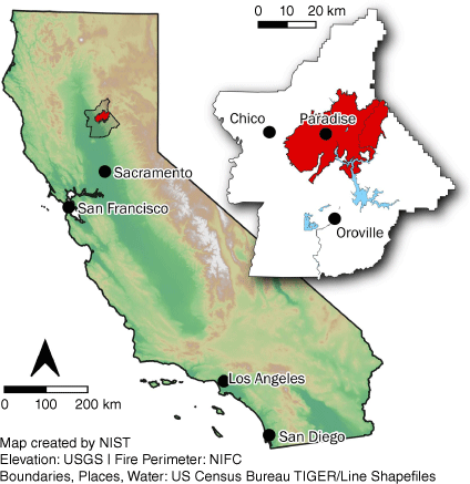
The Camp Fire, which occurred in Butte County in northern California in 2018, was the most destructive and deadly fire in California history (CAL FIRE 2022). The fire ignited at approximately 0615 hours on 8 November 2018 near Camp Creek Road (for which the fire is named) in the small community of Pulga, located in the Feather River Canyon (CAL FIRE 2019a; Butte County District Attorney 2020). The first report of the fire was made at 0625 hours and the initial response was dispatched at 0631 hours. Dry fuel conditions, a strong wind event and steep wind-aligned topography presented conditions conducive to rapid fire spread. By 0730 hours, just over 1 h after ignition, high winds up to 22 m/s (50 miles/h) had driven the fire from the origin, over a ridge and into the community of Concow 6.4 km (4 miles) to the southwest. The first evacuation orders for locations in Paradise (in accordance with the pre-existing evacuation plan) were requested by the incident commander at 0746 hours. By 0800 hours, numerous spot fires were igniting throughout the eastern portion of the town of Paradise an additional 6 km (3.75 miles) southwest of Concow. Structures in Paradise were burning by 0830 hours as thousands of civilians were evacuating. The rapid fire spread led to 85 fatalities (Butte County Sheriff 2019; CAL FIRE 2019b; Butte County District Attorney 2020), and within 12 h, a majority of the structures in Paradise had burned. Ultimately, over 18 000 structures were destroyed and over 700 structures were damaged by the fire (Wallingford 2018; CAL FIRE 2022). Fig. 1 depicts the location of Butte County within the state of California with the final fire perimeter shown in red.
|
After a preliminary reconnaissance (Maranghides et al. 2020a, 2020b), it was determined that an in-depth case study of the incident was feasible owing to the data available and would have scientific merit. The objective of the overall case study was to characterise fire progression, life safety and first responder actions for the first 24 h of the incident. Subsequent data collection and data integration were conducted to reconstruct a detailed timeline of the fire to provide a foundation for additional data analysis (Maranghides et al. 2021). The results presented here constitute a subset of the findings specifically related to the numerous life-threatening burnover events, collectively involving hundreds of civilians and dozens of first responders, that were identified during the case study (Maranghides et al. 2021). The interested reader is encouraged to study Maranghides et al. (2021) for the most detailed fire progression data available. An animation of the analysed fire observation data showing a non-interpolated view of fire progression is provided in the Supplementary Material S1. Although over 2200 data points were included, the spatial resolution and detail required to provide accurate temporal contours is not possible at this scale without consistent widespread aerial measurement.
Entrapments and burnovers
Entrapments in wildland fires are defined by the National Wildfire Coordinating Group (NWCG) as ‘a situation where personnel are unexpectedly caught in a fire behaviour-related, life-threatening position where planned escape routes or safety zones are absent, inadequate, or compromised. An entrapment may or may not include deployment of a fire shelter for its intended purpose. These situations may or may not result in injury. They include ‘near misses.’’ (National Wildfire Coordinating Group 2022a; Page and Freeborn 2019). A burnover is further defined as an entrapment in which ‘fire moves through a location or overtakes personnel or equipment […] often resulting in personal injury or equipment damage’ (National Wildfire Coordinating Group 2022b; Page and Freeborn 2019) and may even result in loss of life. A recent report by Page et al. (2019), considering a comprehensive database of firefighter entrapments in the US indicates entrapment rates have been steady at approximately nine incidents per year.
In the US, most entrapment documentation is related to firefighters during operations, rather than civilians. Internationally, there are few studies about burnover events involving civilians unless they are focused on fatalities (Blanchi et al. 2014; Diakakis et al. 2016; Haynes et al. 2019; Molina-Terrén et al. 2019). In general, the number of entrapments or burnover events involving civilians is likely undercounted because they are not widely publicised, reported, or studied. As more fires burn rapidly into wildland–urban interface (WUI) areas with little time to evacuate, the potential for burnovers is increasing. Recent events with civilian fatalities while attempting evacuation have been documented in Portugal (Viegas et al. 2017, 2019) and Greece (Horowitz 2018; Xanthopoulos and Athanasiou 2019).
During the Camp Fire, numerous events occurred where fire temporarily restricted through-access on a major traffic artery or a secondary road and trapped civilians or first responders amid dangerous fire conditions. The fire exposures of the events varied in intensity and duration. Some impacted civilian evacuation while others impacted first responders only. Some burnovers resulted in civilian fatalities, civilian and first responder injuries, and destruction and damage of civilian and first responder vehicles. In other cases, burnovers did not result in fatalities, injuries, or damage. These were instances in which fire blocked the road and civilians caught in traffic and/or first responders attempting to access the scene either waited for conditions to improve or opted to take another route, if available. These events could be interpreted as entrapments or ‘near misses’ with respect to the NWCG definitions but are included in this report as they have significant impact on civilian and first responder life safety. All identified events were grouped and labeled as burnovers in this report for simplicity, acknowledging the uncertainty in the data regarding exact extent, fire intensity and changing exposure conditions, and the number of people involved in each event.
Specifically understanding the fire development and progression associated with individual burnover events will require in-depth spatial and temporal (pre-, during and post-fire) data collection of local fuels, weather and topography. These detailed data were beyond the scope of the current work, which identified the prevalence of these types of events during the Camp Fire and the significant potential for hundreds of additional fatalities.
Methods
During the 9 months after the fire, researchers conducted technical discussions with 157 first responders directly involved in the first 24 h of the incident to document their first-hand observations related to fire behaviour, evacuations, traffic, defensive actions (i.e. suppression) and weather. Supporting data including photos, videos, radio logs and automatic vehicle locating (AVL) tracks from available fire service apparatus were also collected. Over 2200 fire observation data points were generated, each assigned a geographic location and timestamp. Through extensive cross-referencing and quality control to reconcile inconsistencies, the data points were integrated to compile a timeline of the fire spread. An animation of the fire progression using these data points is available in the Supplementary Material S1. Additional detail about the data collection and data integration processes can be found in Maranghides et al. (2021).
Further analysis of the observations data identified a number of entrapment and burnover events that occurred during the first 24 h of the Camp Fire incident, many involving large groups of evacuating civilians (20 to >100 people). Owing to the important life-safety implications of such events, further information was documented to interpret each event. Through an iterative approach, important characteristics were established to help define the particulars of these burnovers. An initial review of all potential burnover events within the fire observation dataset was followed by a detailed characterisation of the identified key parameters within the constraints of the available information. The location, spatial extent, start time and duration were identified. Specifics related to the location included the roadway width, vegetation setback and length of roadway affected. Additional characteristics were determined, including the relative severity of the burnover event and whether the event impacted evacuating civilians, resulted in the formation of a temporary refuge area (TRA), involved deployment of fire shelters, or resulted in fatalities. Fuel consumption data, heat release rate and quantitative radiative exposure data would be desired to better quantify these events; however, those types of data were unavailable. Similarly, there were no consistently available data regarding injuries, particularly to civilians.
The location and spatial extent of each event (approximated based on observational data points and mapped using GIS (Geographic Information System)), typically along roadways, were identified and characterised based on various first-hand observations along with photos and videos. The spatial extent includes areas where people were trapped or exposed to severe fire conditions along the roadway. Abandoned and burned vehicles left behind in the roadway also indicated the extent of several events. Location attributes of roadway width (measured from aerial imagery using GIS) and vegetation setback from the road (estimated from imagery and on-site observation) were quantified. These metrics provide a relative sense of available separation from fuels to pedestrians and vehicles, and any potential space available for sheltering.
The start time of each event was identified as the time at which fire impacted the people involved (civilians and/or first responders). The end time of each event was defined as the time when people were able to continue evacuating or move to a different location from where they were trapped or burned over. Owing to limitations in the available data resolution, the burnover event end time does not necessarily correspond to the end of hazardous fire conditions, which may have decreased in severity before or after the end of a particular event.
While all were life-threatening, not all identified burnover events were characterised by the same degree of life-safety threat. Events were divided into two categories with respect to the relative risk of injury or death based on a qualitative review of first-hand descriptions and any available videos and photographs of each burnover. The more hazardous ‘Category 1’ was reserved for events including intense flame exposures, damage to equipment, or known injuries or fatalities.
The impacts of fire exposure on life-safety were considered with respect to civilian evacuation, refuge and sheltering actions, and fatalities. It was noted specifically when civilians experienced severe fire exposure and became trapped during evacuation; in other cases, first responders were involved without civilians present. The status of traffic conditions prior to the start of high fire exposure was documented, i.e. when gridlocked traffic was impacted by fire versus when fire conditions stopped and entrapped otherwise flowing traffic. Subsequent actions of refuge, such as deployment of fire shelters or formation of TRAs (immediately available temporary zones leveraging localised areas of reduced fuels and/or fire exposures) were also noted. Known civilian fatalities (officially compiled by the Butte County District Attorney 2020) were referenced for any relationship to the identified burnover events.
Results
Twenty-three entrapment and burnover events where civilians and/or first responders were trapped or overcome by fire were identified in the analysis and compilation of data collected from 157 individual first responder accounts as well as numerous photos and videos. Many of the burnovers adversely affected pre-planned evacuation routes and led directly to the implementation of TRAs to increase life safety. The detailed narrative of each event is beyond the scope of this paper, but is documented in Maranghides et al. (2021), and conveys the range of different scenarios under which burnovers occurred.
The presented list of 23 burnover events does not include an analysis of the local conditions associated with most of the 85 documented fatalities. Therefore, additional burnovers may have occurred that were not captured during the data collection process; however, there is high confidence that nearly all of the large burnover events that occurred on egress arteries and/or involved multiple civilians are accounted for based on the total combined dataset of fire observations (Maranghides et al. 2021), traffic conditions, burned vehicles and TRAs.
The 23 documented burnover events occurred throughout the fire area during the first 26 h of the incident, beginning almost immediately as fire impacted the community of Concow. The location and spatial extent of each event is marked in Fig. 2 with the corresponding ID number, listed in chronological order, with additional details in Table 1.

|

|
The significant volume of civilian evacuation traffic played a major role in the population exposed to these burnover events. Seventeen entrapments and burnovers involved an estimated combined total of 300–500 evacuating civilians. Twelve events occurred on primary egress arteries (identified by bold type in Table 1). In five cases, evacuating traffic was stopped owing to gridlock or a non-fire obstruction before the arrival of the fire front. Civilians were then unable to escape as the fire burned through the area where they were trapped. These events are indicated in the ‘Traffic gridlock or obstruction’ column of Table 1. The other seven events impacting civilian evacuation involved fire impeding and trapping or exposing moving traffic to intense fire. The remaining six events that did not impact civilian evacuations involved first responders during operations; most of these incidents occurred after the majority of civilians had evacuated.
Nine events required the formation or utilisation of TRAs to maintain life safety for residents and firefighters. In many of these cases, the roadway or intersection was the only TRA available. Exceptions included the creek, which was used in event ID no. 1, and grassy areas, which were used in events no. 20 and no. 7. Only one event involved active fire suppression from a fire engine (ID no. 8). In at least two cases, fire shelters were deployed by firefighters to reduce radiative exposure to civilians and first responders (ID no. 1, no. 7). Several entrapments and burnovers resulted in first responder injuries and civilian fatalities. Although injuries were not systematically accounted for in the available data, especially regarding civilians, two events resulted in documented firefighter injuries (ID no. 15, no. 17). Three of the identified events (ID no. 5, no. 7, no. 21) were associated with civilian fatalities as victims were burned over while attempting to flee the fire in vehicles.
Fourteen burnovers were identified as Category 1, representing higher potential of death or injury, and nine as less-hazardous Category 2 events. Of the 11 burnovers that occurred before 1000 hours on 8 November, nine were listed as Category 1, and two as Category 2. All but one of the Category 1 burnovers on the morning of 8 November involved evacuating civilians. Seven of the 14 Category 1 burnovers resulted in the formation of TRAs.
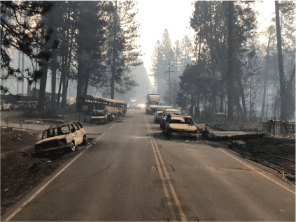
Local conditions dictated the temporal and spatial extent of each burnover. Burnover event durations averaged nearly 2 h and were influenced by the type and quantity of vegetative and WUI fuels (e.g. structures and vehicles), as well as the spatial extent of the event. The identified durations represent the total time the people involved in the event were trapped or stuck at the burnover location after arrival of fire. In some cases, the worst hazardous conditions did not extend for the full reported duration, while in others, first responders were able to move civilians out of the hazardous conditions before high exposures subsided. The longest-duration burnover was ID no. 4 on Skyway north of Wagstaff Road, which occurred over 6 h and impacted an extent of 2.6 km (1.6 miles). The duration and area of this event were influenced by the fuels, fire spread direction and intermittent use of this important egress artery for evacuation and first responder access, which resulted in the involvement of several groups of civilians and first responders. Fig. 3 shows a photograph of numerous abandoned and burned vehicles in the roadway within the burnover extent. A total of 85 vehicles were abandoned amid fire exposures within a 1.6 km (1.0 miles) segment of Skyway.
|
As shown in Fig. 2 and indicated by the length of roadway affected listed in Table 1, many of these burnover events affected a significant area along primary roadways. On average, over 800 m (0.5 miles) of roadway was impacted per burnover, and lengths ranged from 150 m up to 3 km (1.8 miles). A total of 19 km (12 miles) of roadway were involved in burnovers. The individual extents and cumulative 19 km of affected roadways highlight that these burnover events did not affect only ‘point’ locations, and that the spatial extent made them difficult to escape and encompassed many evacuees.
Although fire exposures were not quantifiable, vegetation setback distance and roadway width can provide context for the available separation between the burning vegetative fuels and the exposed civilians and vehicles. Overall, vegetation setbacks from the roadway (estimated using photos, video and imagery) ranged from 0 to 10 m (33 ft); however, in most instances the setbacks were 3 m (10 ft) or less. Setbacks were variable throughout each affected burnover area, indicated by the provided ranges in setback distance. Vegetation along roadways was generally heavier than grass and was often a mix of shrubs, trees and ornamental vegetation. In the cases where reported setbacks were greater than zero, there was little or no vegetation within that fuel setback area to generate hazardous fire exposure. Two events (ID no. 20, no. 15) occurred off-road in grass, and setback distances are reported as 0 m in Table 1. Larger setbacks were frequently related to the presence of green spaces (e.g. yards) or parking areas. The setback of structures was not explicitly assessed but was generally larger than the reported vegetation setback. Although located further away than vegetation, burning structures generated intense and long-duration fire exposures contributing to the burnover severity and impacting egress routes in many of the identified burnover events. Road widths ranged from 3 m (10 ft) on narrow tertiary local roads to 23 m (75 ft) wide multi-lane primary arteries.
Discussion and implications of findings
One may first notice the large number of identified events, particularly in comparison with the average of nine documented firefighter entrapments and burnovers each year in the US. The mission focus of the fire service, the specific definition of burnovers versus entrapments, as well as the potential negative stigma of burnovers (Strohmeyer et al. 2018), may all combine to a general under-reporting of such events (Jolly et al. 2019). Additionally, the majority of reported entrapments are likely reported in wildland fire settings as opposed to WUI fire settings in more developed infrastructure with additional urban fire service mutual aid. The fact that 23 individual instances were identified within one incident suggests that this may be a more frequent issue specifically in the context of WUI fires. Fourteen incidents were labelled Category 1, indicative of higher severity and significant threat to life.
It is important to note that these events also had a significant impact on civilians. Overall, these events have a different narrative compared with many firefighter-only burnovers experienced during suppression efforts. Of the 23 events, only 2 include officially documented firefighter injuries sustained during fire suppression efforts. Those events, ID no. 15 and no. 18, injured five firefighters and were reported in an after-action ‘Green Sheet’ report (CAL FIRE 2018). The rest of the identified events were dominated by civilian presence, often with the assistance or guidance of first responders to locate a safer TRA. In very few cases was active suppression used or available to protect civilians from fire exposure, often owing to the severity of fire exposures. Further, the finite emergency resources were primarily involved in spatially dispersed evacuation and search and rescue activities. In one case (ID no. 8), a fire engine was able to provide protection using an available hydrant. The scale of the Camp Fire resulted in exposures to hundreds of structures simultaneously, outpacing the capabilities of the resources. Mobility of first responders and access throughout the fire area were impeded by fire and traffic.
Half of the events (ID nos 4, 6, 7, 8, 21, 9, 10, 11, 12, 22, 23) occurred in Paradise during overlapping time windows early in the incident, stressing emergency resources. Simultaneous events, particularly across large spatial areas, significantly stretch the resources available to respond to each event to protect evacuating civilians. Early evacuation is key; however, this may not always be feasible. In rapidly developing events, a well-planned and efficient evacuation plan will need to be tailored to local conditions and potential wildfire behaviour. Improved wildland and WUI fire spread prediction modelling capabilities in the future could enhance the development of evacuation plans. During the first 24 h of the Camp Fire, every primary egress artery experienced at least one burnover event. The need to protect civilian evacuations may significantly change the operations of the fire service, resulting in additional fire spread and structure and infrastructure loss.
Whereas 14 of the 23 incidents occurred before 1100 hours on Day 1 (when more civilians were involved), several did occur the following day on 9 November, impacting first responder safety and operations. The potential for such events must be considered throughout the entire incident, not only for first responders but also in situations where fire continues to progress and impact additional populated areas. There are also significant long-lasting effects of burnovers, and fire passage in general, in WUI areas, particularly as abandoned and burned vehicles and burned and downed utility poles and lines can block passage for hours, impacting evacuation and first responder operations. Note that these effects can impact narrow local roadways as well as multi-lane primary egress arteries. The proximity of multiple concurrent burnover events on key roadways can cause ripple effects throughout the road network, restricting evacuation of civilians that are not directly within the burnover, potentially leading to subsequent burnover events.
Conclusions
This portion of a greater case study into the 2018 Camp Fire in Butte County, California, presents a unique dataset of burnover events, most of which impacted civilians during mass evacuation from three WUI communities. Twenty-three burnover events threatening the safety and trapping or restricting movement of first responders and hundreds of evacuating civilians were identified through in-depth analysis of data collected from technical discussions with first responders. Seventeen burnovers directly impacted evacuating civilians, 12 of which occurred on major evacuation roadways. Most burnover events lasted between 1 and 2 h and impacted an average roadway length of 800 m. Two events injured firefighters and were documented by CAL FIRE in an official ‘Green Sheet’ informational summary report.
This is an important area of study as the frequency of fast-moving fires requiring last-minute large-scale evacuations increases. In intermix communities, the presence of primarily wildland vegetation burning along evacuation routes and some secondary roadways, often amplified by effects of local topography and wind, can result in significant entrapments and burnovers. There is limited technical information to provide reliable guidance for the protection of egress arteries against these potential severe fire exposures; additional research is needed to characterise fire behaviour and conditions leading to burnovers and to quantify burnover severity. Quantitative information specifically with respect to (1) exposures generated in settings of interest, (2) acceptable thresholds of exposures on civilians and first responders, and the relationships between (1) and (2) will provide a baseline for the generation of guidance specifically including management of vegetative and other WUI fuel types, fuel densities and fuel setbacks from the roadway for specific topographical settings. Such a study would require localised reconstruction of fire behaviour (fuels, weather, topography) within the context of the entire incident and additional data collection to quantify the exposures generated from the burning wildland and WUI fuels. This work must be undertaken immediately following the event, as much of the data will originate from first-hand observations and perishable field data, such as post-fire fuel consumption measurements. This detailed information would support development and interpretation of fire models, inform fuel setback guidance for primary egress arteries and provide technical input to evacuation plans.
Supplementary material
Supplementary material is available online.
Data availability
Data are available from Appendix B (burnover data) and Appendix F (fire spread data) in NIST Technical Note 2135 (doi.org/10.6028/NIST.TN.2135).
Conflicts of interest
The authors declare no conflicts of interest.
Declaration of funding
This research was funded by the NIST, US Department of Commerce.
Acknowledgements
The authors would like to acknowledge Ruddy Mell, Steven Hawks, Mike Wilson, Will Brewer, Chris Brown, Bob Vihnaneck and Doug Walton for their contributions to the overall case study effort. The authors also acknowledge the many first responders and community officials who contributed their time and information to the case study, as well as the data collection teams who participated in the technical discussions to collect much of the data used to compile the information in this report.
References
Blanchi R, Leonard J, Haynes K, Opie K, James M, Dimer de Oliveira F (2014) Environmental circumstances surrounding bushfire fatalities in Australia 1901–2011. Environmental Science & Policy 37, 192–203.| Environmental circumstances surrounding bushfire fatalities in Australia 1901–2011.Crossref | GoogleScholarGoogle Scholar |
Butte County Sheriff's Office (2019) Camp Fire Update. Press Release, 25 September 2019, Oroville, CA.
Butte County District Attorney (2020) ‘The Camp Fire Public Report: A Summary of the Camp Fire Investigation.’ (Butte County District Attorney: Oroville, CA) Available at https://www.buttecounty.net/DocumentCenter/View/1881/Camp-Fire-Public-Report---Summary-of-the-Camp-Fire-Investigation-PDF?bidId= [verified April 2023]
CAL FIRE (2018) Informational Summary Report of Serious or Near Serious CAL FIRE Injuries, Illnesses and Accidents (Green Sheet). Available at https://www.firefighterclosecalls.com/wp-content/uploads/2018/12/18-CA-BTU-016737-Camp-Green-Sheet.pdf [verified June 2022]
CAL FIRE (2019a) CAL FIRE Investigators Determine Cause of the Camp Fire. Press Release, 15 May 2019, Sacramento, CA.
CAL FIRE (2019b) Top 20 Deadliest California Wildfires. Updated 8 August 2019.
CAL FIRE (2022) Top 20 Most Destructive California Wildfires. Updated 13 January 2022.
Diakakis M, Xanthopoulos G, Gregos L (2016) Analysis of forest fire fatalities in Greece: 1977–2013. International Journal of Wildland Fire 25, 797–809.
| Analysis of forest fire fatalities in Greece: 1977–2013.Crossref | GoogleScholarGoogle Scholar |
Haynes K, Short K, Xanthopoulos G, Viegas D, Ribeiro LM, Blanchi R (2019) Wildfires and WUI Fire Fatalities. In ‘Encyclopedia of Wildfires and Wildland–Urban Interface (WUI) Fires’. (Ed. S Manzello) pp. 1–16. (Springer: Cham)
| Crossref |
Horowitz J (2018) As Greek Wildfire Closed In, a Desperate Dash Ended in Death. The New York Times, 24 July 2018. Available at https://www.nytimes.com/2018/07/24/world/europe/greece-wildfire.html [verified June 2022]
Jolly M, Butler B, Page W, Freeborn P (2019) An Assessment of Research Needs Related to Wildland Firefighter Safety. Final Report JFSP Project ID: 18-S-01-1. (USDA Forest Service, Rocky Mountain Research Station: Missoula, MT). Available at https://www.firescience.gov/Publications/Final_Report_JFSP_18-S-01-1.pdf [verified June 2022]
Maranghides A, Mell W, Hawks S, Wilson M, Brewer W, Link E, Brown C, Murrill C, Ashley E (2020a) Preliminary Data Collected from the Camp Fire Reconnaissance. NIST Technical Note 2128. (National Institute of Standards and Technology: Gaithersburg, MD)
| Crossref |
Maranghides A, Mell W, Hawks S, Wilson M, Brewer W, Link E, Brown C, Murrill C, Ashley E (2020b) Camp Fire Preliminary Reconnaissance. NIST Technical Note 2105. (National Institute of Standards and Technology: Gaithersburg, MD).
| Crossref |
Maranghides A, Link E, Mell W, Hawks S, Wilson M, Brewer W, Brown C, Vihnaneck B, Walton WD (2021) A Case Study of the Camp Fire – Fire Progression Timeline. NIST Technical Note 2135. (National Institute of Standards and Technology: Gaithersburg, MD)
| Crossref |
Molina-Terrén DM, Xanthopoulos G, Diakakis M, Ribeiro L, Caballero D, Delogu GM, Viegas DX, Silva CA, Cardil A (2019) Analysis of forest fire fatalities in Southern Europe: Spain, Portugal, Greece and Sardinia (Italy). International Journal of Wildland Fire 28, 85–98.
| Analysis of forest fire fatalities in Southern Europe: Spain, Portugal, Greece and Sardinia (Italy).Crossref | GoogleScholarGoogle Scholar |
National Wildfire Coordinating Group (2022a) Entrapment. Available at https://www.nwcg.gov/term/glossary/entrapment [verified June 2022]
National Wildfire Coordinating Group (2022b) Burnover. Available at https://www.nwcg.gov/term/glossary/burnover [verified June 2022]
Page WG, Freeborn PH (2019) Entrapment. In ‘Encyclopedia of Wildfires and Wildland–Urban Interface (WUI) Fires’. (Ed. S Manzello) pp. 1–7. (Springer: Cham)
| Crossref |
Page WG, Freeborn PH, Butler BW, Jolly WM (2019) A review of US wildland firefighter entrapments: trends, important environmental factors and research needs. International Journal of Wildland Fire 28, 551–569.
| A review of US wildland firefighter entrapments: trends, important environmental factors and research needs.Crossref | GoogleScholarGoogle Scholar |
Strohmeyer J, Burbridge B, Carey S, Zimmerlee R, Weaver T, Apuzzo G, Dotson T (2018) Horse Park Fire Entrapment Facilitated Learning Analysis. (USDA Forest Service, Boise National Forest: Boise, ID). Available at https://wildfiretoday.com/documents/Horse_Park_Fire_FLA.pdf [verified June 2022]
Viegas DX, Almeida MF, Ribeiro LM, Raposo J, Viegas MT, Oliveira R, Alves D, Pinto C, Jorge H, Rodrigues A, Lucas D, Lopes S, Silva LF (2017) ‘O Complexo de Incêndios de Pedrógão Grande e concelhos limítrofes, iniciado a 17 de junho de 2017.’ (Centro de Estudos sobre Incêndios Florestais (CEIF/ADAI/LAETA): Coimbra, Portugal) [In Portuguese]
Viegas DX, Almeida MA, Ribeiro LM, Raposo J, Viegas MT, Oliveira R, Alves D, Pinto C, Rodrigues A, Ribeiro C, Lopes S, Jorge H, Viegas CX (2019) ‘Análise dos Incêndios Florestais Ocorridos a 15 de outubro de 2017.’ (Centro de Estudos sobre Incêndios Florestais (CEIF/ADAI/LAETA): Coimbra, Portugal)
Wallingford N (2018) Camp Incident Damage Inspection Report. (CAL FIRE: Sacramento, CA)
Xanthopoulos G, Athanasiou M (2019) The Fire Globe: Attica Region, Greece (July 2018). Wildfire 28, 18–21.