

Evaluation of new methods for drought estimation in the Canadian Forest Fire Danger Rating System
Chelene C. Hanes A B * , Mike Wotton A B , Laura Bourgeau-Chavez C , Douglas G. Woolford D , Stéphane Bélair E , David Martell A and Mike D. Flannigan FA Institute of Forestry and Conservation, John H. Daniels Faculty of Architecture, Landscape and Design, University of Toronto, 33 Willcocks Street, Toronto, ON M5S 3B3, Canada.
B Great Lakes Forestry Centre, Canadian Forest Service, Natural Resources Canada, 1219 Queen Street East, Sault Ste Marie, ON P6A 2E5, Canada.
C Michigan Tech Research Institute, 3600 Green Crescent Suite 100, Ann Arbor, MI 48105, USA.
D Statistical and Actuarial Sciences, University of Western Ontario, 1151 Richmond Street, London, ON N6A 3K7, Canada.
E Environment and Climate Change Canada, Meteorological Research Division, 2121 Route Transcanadienne, Dorval, QC H9P 1J3, Canada.
F Natural Resource Science, Thompson Rivers University, 805 TRU Way, Kamloops, BC V2C 0C8, Canada.
International Journal of Wildland Fire 32(6) 836-853 https://doi.org/10.1071/WF22112
Submitted: 1 July 2022 Accepted: 16 March 2023 Published: 6 April 2023
© 2023 The Author(s) (or their employer(s)). Published by CSIRO Publishing on behalf of IAWF. This is an open access article distributed under the Creative Commons Attribution-NonCommercial-NoDerivatives 4.0 International License (CC BY-NC-ND)
Abstract
Background: Canadian fire management agencies track drought conditions using the Drought Code (DC) in the Canadian Forest Fire Danger Rating System. The DC represents deep organic layer moisture.
Aims: To determine if electronic soil moisture probes and land surface model estimates of soil moisture content can be used to supplement and/or improve our understanding of drought in fire danger rating.
Methods: We carried out field studies in the provinces of Alberta and Ontario. We installed in situ soil moisture probes at two different depths in seven forest plots, from the surface through the organic layers, and in some cases into the mineral soil.
Results: Our results indicated that the simple DC model predicted the moisture content of the deeper organic layers (10–18 cm depths) well, even compared with the more sophisticated land surface model.
Conclusions: Electronic moisture probes can be used to supplement the DC. Land surface model estimates of moisture content consistently underpredicted organic layer moisture content.
Implications: Calibration and validation of the land surface model to organic soils in addition to mineral soils is necessary for future use in fire danger prediction.
Keywords: boreal forest, Drought Code, fuel moisture, in situ, modelling, remote sensing, soil moisture probe, wildfire.
Introduction
Throughout most typical fire seasons, the principal day-to-day short-term indicators of fire danger, ignition potential and rate of spread are of primary concern to fire managers. The moisture content of the litter layer and underlying fine to medium organic fuels heavily influence fire behaviour through their interaction with local weather and topography. Hot, dry and windy conditions can quickly dry out these layers, which can lead to more fire activity and more intense fires. Long-term drought and continuous drying in deeper, denser organic fuels can make a challenging fire season quickly turn into something much worse. With climate change, drought conditions are becoming more commonplace (Kitzberger et al. 2017; Pausas and Keeley 2021) and can lead to more problematic fire seasons (Elmes et al. 2018; Chavardès et al. 2019; Thompson et al. 2019; Whitman et al. 2019). Therefore, our ability to quantify drought in fire danger rating is becoming more important.
The Drought Code (DC), one of three moisture codes in the Fire Weather Index (FWI) System, measures drought in the Canadian Forest Fire Danger Rating System (CFFDRS). Similar drought indices used for fire danger rating exist in other jurisdictions, such as the Keetch–Byram Drought Index (Keetch and Byram 1968) and the Palmer Drought Index (Palmer 1965). One important, but subtle, difference is that the DC is designed to directly estimate the lack of moisture in denser organic layers rather than using hydrologic drought in the mineral soil as a proxy for fuel moisture deficiencies. The DC has been associated with moisture changes in deep, dense organic layers and large downed woody debris (Muraro and Lawson 1970; Van Wagner 1974b; Russell 1975; Lawson 1977). The layer of the forest floor nominally tracked by the DC has depth of 15–18 cm and nominal fuel load of 25 kg/m2, in keeping with the standard pine fuel on which the FWI System is based (Van Wagner 1987).
The DC was developed from the Soil Moisture Index (SMI) (Turner 1966) by transforming the SMI from a scale of available moisture to an index of cumulative drying for use within the FWI System (Turner 1972). For each rainless day, the DC increases by one-half the Potential Evapotranspiration (PET). Moisture is added to the DC as effective rainfall once a minimum rainfall amount of 2.8 mm is exceeded (Van Wagner 1987). The effective rainfall is assumed as the amount of moisture available for storage within the fuel after interception by the canopy (Turner 1972). The PET calculation in the DC is a simplification of the method proposed by Thornthwaite and Mather (1955); it has been adjusted to be consistent with the FWI System’s daily inputs and its output of moisture ‘codes’. It uses the daily temperature at noon local standard time, 24-h accumulated precipitation and a seasonal adjustment of day length. To be consistent with the format of the other moisture codes in the FWI System, the SMI was converted to a logarithmic scale that increases in value with increasing dryness. At their inception, neither the SMI nor the DC were intended to represent the moisture content of any specific class of fuels, but validation after the fact indicated moisture changes in dense organic layers fitted the simple exponential drying model of the DC (Van Wagner 1974a; Russell 1975; Lawson 1977).
The conversion from DC to Moisture Content (MC) takes the form

It is important to note that this equation as given in Wotton (2009) differs slightly from that given in Van Wagner (1987) in order to account for the fact that the moisture content is one-half the moisture equivalent at saturation. Van Wagner (1987) did not explicitly present the conversion between DC and gravimetric moisture itself, but noted that the maximum gravimetric moisture content of the DC is 400% at saturation (DC = 0), which corresponds to a soil moisture equivalent of 800 in the original DC model. This important difference in the interpretation of the conversion between measured actual moisture content and the code value has been a problem in more recent studies that have looked at further field validation of the DC (e.g. Lawson and Dalrymple 1996; Wilmore 2001). Those studies highlighted differences between ground-sampled data and the soil moisture equivalent value from the DC calculation and not the moisture content conversion.
Operationally, the DC has been used to assess potential lightning ignition holdover, persistent deep smouldering and mop-up problems (Muraro 1975; Hirsch and Martell 1996). It has also been associated with increased depth of burn (de Groot et al. 2009), the occurrence of long-term drought conditions (Girardin et al. 2004) and the control time for human-caused fires in Ontario (Morin et al. 2015). Lastly, the season-ending values of the DC are often considered at the start of the new fire season. The DC is often used as a method to account for the accumulated effect of year-to-year drought in Canada because it integrates a deeper, heavier and consequently more slowly changing layer of the forest floor, making it well suited to accumulate the effect of longer-term weather (Van Wagner 1985). The DC has a timelag of approximately 53 days (Lawson and Armitage 2008), although this value varies with temperature. Because of this long timelag and the large water-holding capacity of the layer modelled by the DC, it was hypothesised that the DC could carry over drought effects from one season into the next using an overwintering procedure (Turner and Lawson 1978). This procedure adjusts the spring starting value of the DC based on the DC value prior to freeze-up, or snow accumulation the previous fall (autumn), and the estimated amount of moisture available for recharge from overwinter precipitation.
Since the development of the DC, most research has focused on how to establish the starting spring values and field validation of the DC using destructive sampling methods (Stocks 1979; Alexander 1982; Lawson and Dalrymple 1996; Otway et al. 2007). More recent studies have developed correlations with organic soil moisture using electronic moisture probes (Keith et al. 2010; Terrier et al. 2014; Elmes et al. 2018). Such methods are less time consuming and allow greater temporal and spatial variability in measurements. Those instruments rely on soil dielectric properties, which can vary with soil composition, and clay and organic content (Kellner and Lundin 2001; Bourgeau-Chavez et al. 2010). Despite good correlations with the measurements produced using these probes, questions remain operationally around probe installation and use and what soil layers best correlate with the DC.
The DC has also been shown to have strong correlation to C-band (~6 cm wavelength) Synthetic Aperture Radar (SAR) backscatter in low-biomass areas (Bourgeau-Chavez et al. 1999, 2007). An algorithm developed by Bourgeau-Chavez et al. (2007) was shown to be useful to initialise DC start-up values in Alaska. Further work by Bourgeau-Chavez et al. (2013) using polarimetric C-band SAR (Radarsat2) was successful at improving the soil moisture estimation in higher-biomass areas. Although such research demonstrates the potential use of earth observation to map organic soil moisture, there remain limitations to remote sensing of soil moisture in forested regions due to high biomass and waterbodies (Magagi et al. 2013; Pan et al. 2016; Jin et al. 2017).
More sophisticated land surface models may alleviate some of the remote sensing issues; studies in other regions have shown improved drought estimation by incorporating land surface modelling outputs (Cooke et al. 2012; Yang et al. 2015; Vinodkumar and Dharssi 2019) into fire danger methods to represent soil moisture changes. This approach has not been explored for the dense boreal forests in Canada. Inclusion of earth observations from an existing product, like Environment and Climate Change Canada’s (ECCC) Canadian Land Data Assimilation System (CaLDAS) (Carrera et al. 2015, 2019), is an emerging area for fire science in Canada. CaLDAS integrates information from L-band satellites SMAP (Soil Moisture Active Passive) and SMOS (Soil Moisture Ocean Salinity) as well as the geostationary satellite GOES (Geostationary Operational Environmental Satellite) with high-resolution land surface modelling and ground-level observations to produce estimates of soil moisture and surface temperature across Canada every 3 h.
To further explore what organic soil depths the DC is tracking, and determine the potential added intelligence electronic soil moisture content probes and land surface modelling data could provide, a field-based study was conducted in the provinces of Alberta and Ontario, Canada. This study had the following three objectives: (1) determine how well the DC correlates to organic soil moisture and at which depths, using WCR (water content reflectometry) probes; (2) explore the use of land surface models (CaLDAS) to represent moisture changes in these deep organic layers; (3) determine if CaLDAS estimates of soil moisture can be used to estimate or correct the DC.
Methods
Field data
Four field sites were included in the study; two in Alberta near Edson and Red Earth Creek (REC), and two in Ontario near Dryden and Chapleau (Fig. 1). At each study site, except Chapleau, one 200 × 200-m plot was installed in a specific forest type (Table 1). There were four 200 × 200-m plots at the Chapleau site, each in a different forest type. Each of the four study sites is located within 40 km of a fire weather station. Each plot was instrumented with eight to twelve 30-cm Campbell Scientific (CS) CS616 WCR probes (Supplementary Table S1). Electronics embedded in the probe head send a signal down the probe; the probe then acts as a wave guide. The return time of the signal is measured as the period. The period of the electromagnetic wave is a function of the wave guide length, the speed of light and the electrical permittivity of the surrounding medium (Overduin et al. 2005). Calibration equations convert the probe period to Volumetric Moisture Content (VMC) based on the probe sensitivity to the dielectric constant of the medium surrounding the probe rods (Campbell Scientific 2020). Probes were installed from the surface at an angle so that the length of the probe integrated its measurement over a prescribed depth (10 and 18 cm) within the litter, fermentation and humus layers (also known as duff layers). Depending on the depth of installation and organic layer depth at the plot, some of the probes were in contact with the mineral horizon. The WCR probes were randomly fanned out from the data loggers to cover as much area as possible. Soil temperature probes (CS-109L) were installed horizontally at specific depths (Supplementary Table S1); temperature probes at Edson were not installed owing to field access issues related to COVID-19 travel restrictions. A default CS temperature correction, using the in situ temperature probes, was applied to the period output of the CS616 probes (Campbell Scientific 2020). Calibration of the temperature-corrected period to VMC was conducted using the calibration equations developed by Bourgeau-Chavez et al. (2010) for different organic soil layers.

|

|
VMC was recorded hourly at all sites. For the purposes of analysis and the comparison with daily DC values, the daily VMC for each plot was the average of all sensors at a specific depth that were reporting at 16:00 LST (Local Standard Time). The data from REC was an exception owing to the lack of consistent hourly data; at this site, the daily average was used.
Fire weather data
DC values were calculated using temperature and 24-h accumulated precipitation from fire weather stations near each field site. Operationally, FWI System values, including the DC, are assumed to be highly reliable within a 40-km radius of weather stations. This is the standard laid out in the Weather Station Guides for the FWI System (Turner and Lawson 1978; Lawson and Armitage 2008). Where we had a second weather station nearby, we were able to test this assumption, as we know it is not always applicable. In keeping with the FWI System standard, weather observations, taken at local noon, were used to calculate the conditions at the period of peak burning, approximately 16:00 LST. DC values were converted to gravimetric moisture content using Eqn 1, then multiplied by the standard DC bulk density (139 kg/m3) to convert to VMC (Supplementary Fig. S1). In order to convert to gravimetric moisture content, the bulk density is needed surrounding each of the probes. Accurate bulk densities for each probe location are not known at this time; therefore, it was more precise to convert the DC to VMC. For comparison of DC with field observations, the DC values were taken as is from the fire management agencies (i.e. if DC spring start values were overwintered these were used as is); they were also calculated without overwintering. For comparison of DC with CaLDAS, DC values were not overwintered and the default value 15 was used to start the spring season calculations for all plots.
CaLDAS data
In the CaLDAS version used for this study, short-range (6-h) forecasts from ECCC’s High Resolution Deterministic Prediction System (HRDPS) are provided as atmospheric forcing to the SVS (Soil, Vegetation and Snow) land surface scheme (Alavi et al. 2016; Husain et al. 2016). Precipitation forcing was provided to SVS by the Canadian Precipitation Analysis (CaPA) (Fortin et al. 2018). The model first guess from SVS is combined with L-band brightness temperature from SMOS and with surface temperature retrievals from GOES, which are assimilated in CaLDAS using an Ensemble Kalman Filter methodology to generate analyses of soil moisture and surface temperature every 3 h. Final moisture values at 21:00 UTC (Coordinated Universal Time)(17:00 LST) were compared for each 2.5-km grid cell that encompassed the field plots based on geographic coordinates. CaLDAS VMC values at three depths – 0–5, 5–10 and 10–20 cm – were obtained for each plot.
Analysis
Comparisons were made between observed field measurements of moisture content at depths, 10 and 18 cm and: (1) daily DC values converted to VMC, and (2) CaLDAS VMC estimates at all three depths. A third comparison was made between daily DC values (expressed as VMC) and CaLDAS VMC at three depths. All analyses were first conducted on daily time series of VMC during the fire season from late spring (May) until early fall (September) for 2019–2021 where available. The hydroGOF R package (Zambrano-Bigiarini 2020) was used to calculate goodness-of-fit statistics for these time series comparisons in R (R Core Team 2020) including: R2 (coefficient of determination), RMSE (root mean square error), NSE (Nash Sutcliffe efficiency), and Pbias (percentage bias). Nash Sutcliffe efficiency is commonly used to assess the predictive skill of hydrologic models and ranges from negative infinity to one, where one represents a perfect match and values of zero indicate model predictions are as accurate as the mean of the observed, and less than zero, the mean is a better predictor than the model (Nash and Sutcliffe 1970). Goodness-of-fit statistics were first calculated for the entire 2019–2021 time series (May through September), then again for each individual year separately to show annual variations.
To further examine the bias between CaLDAS modelled and observed moisture, time series data were first checked for normality. Linear regression analysis was then conducted in R using the lm function, to determine the intercept. The degree of autocorrelation within the time series was then identified using the acf function in R. The maximum lag, where there was evidence of correlation in the time series, was taken from the autocorrelation plots.
Results
Overall, the DC showed good correspondence with duff moisture between 10 and 18 cm, with minimum R2 values of 0.46 for the majority of plots, RMSE between 6 and 16% VMC (Table 2). The differences in goodness-of-fit statistics were generally smaller between different observation depths within a plot compared with differences between plots. The DC to observed moisture relationship had a positive bias for all plots and observation depths in Ontario, implying the DC indicated moister conditions than were observed at the sites, with the exception of the Dryden mixedwood plot at 18 cm VMC, although the Pbias at that site was minimal at 1.8%. The DC to observed moisture relationship had a larger, negative bias for both plots in Alberta at all depths; that is, the DC indicated drier conditions overall than were observed at these locations. The carry-over drought included in the calculation of the DC through overwintering may be the reason for the negative bias in Alberta, especially at REC. For Alberta, the starting DC values in the spring were overwintered each year, therefore starting the seasons’ ‘bookkeeping’ of drying and wetting in the deep organic layers in a much drier state than one would assume had saturation occurred at the time of snowmelt. When these original DC time series are compared with non-overwintered DC estimates of VMC (i.e. spring default value = 15) at Edson (Fig. 2), it is apparent that overwintering the DC had significant impacts on moisture estimation beyond the spring period; the use of the non-overwintered DC resulted in quite different goodness-of-fit statistics (i.e. for 2020 and 2021). For 2019, observations at Edson did not start until July 2019 and for that year, overwintering effects were gone by July. Overall, the non-overwintered DC for all years combined did not improve the goodness-of-fit statistics (Tables 2, 3) again indicating overwintering may be necessary but not accurate at the Edson plot in 2021.

|

|

|
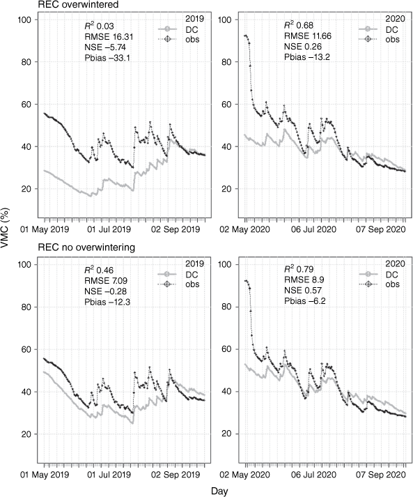
The results at the REC plot differed from those observed at the Edson plot. Overwintering of the DC at the REC plot appears to be the reason for the poor predictive skill of the DC there (Table 2), resulting in much lower spring moisture values that were not representative of much wetter observed VMC in the duff layers (Fig. 3). Goodness-of-fit statistics for REC for all years compared with those in Table 2 for 18 cm were R2 0.58, RMSE 8.02, NSE 0.43, Pbias −9.1 when the DC was not overwintered (Table 3). Therefore, REC is not the outlier it appears to be in Table 2. The poor fit is due to the application of the DC overwintering adjustment, not a lower predictive skill of the DC model.
|
In addition to impacts of overwintering, differences in precipitation can also significantly influence the DC model skill in tracking observed moisture content. Although fire weather data up to 40 km is assumed representative of local conditions, this range does not always capture all convective precipitation events, as shown by the differences in model fit for the Dryden mixedwood plot (Fig. 4). At this site, the fire weather station is 39 km from the plot. As a comparison, the DC was also calculated using a closer ECCC weather station (7 km away). This recalculation resulted in better predictive skill in all years (18 cm R2 0.76, RMSE 6.89, NSE 0.64, Pbias −8.3, Table 3).

|
In comparison, plots within an equal distance (<15 km) of the same fire weather station illustrate that the local plot conditions can also significantly affect the DC model skill (Fig. 5) depending on stand type. The DC estimated VMC at the Chapleau mixedwood plot, which is typically a wet plot with duff 8–12 cm deep (Table 1), had the best overall skill at predicting observed moisture content (Tables 2, 3, Fig. 5). In contrast, the nearby aspen plot, which had comparably drier and thinner duff (~5 cm), had relatively poor skill at estimating 18-cm moisture content (Table 2). Again, predictive skill varied somewhat between years (Fig. 5) for both plots.

|
Overall, once input issues including local precipitation discrepancies and overwintering were eliminated, the DC model had good skill in predicting observed VMC throughout the season. The DC generally captured the timing of precipitation events (Figs 2–5), although the magnitude of response was not always accurate. The mid-summer VMC had reasonable agreement at most plots following drying trends that typically occur. When deviations between the DC and observed moisture were observed, they tended to occur most in the beginning or end of the seasons (Figs 2–5).
In contrast, the more complex CaLDAS model estimates of VMC had poorer skill overall (Table 4) compared with the simpler DC model (Table 2), based on all goodness-of-fit statistics. CaLDAS VMC had a consistent, relatively large negative Pbias, for all modelled depths, compared with all observed VMCs (Table 4). All NSE values indicate the mean observed VMC was a better predictor than the CaLDAS modelled VMC. R2 values >0.4 indicate some higher skill for the Chapleau aspen and Edson mixedwood plots, keeping in mind the Edson 10-cm depths were only for 2020–2021. Although the relationship to the deeper 30-cm observed VMC and shallower 6-cm VMC (not shown) at Edson had better skill than the other plots as well, the improved model skill may be due to something other than a shorter period of record. Despite relatively higher R2 values for Edson, RMSE were quite high (19–28%) and the Pbias was similar to other plots.

|
Similarly to the DC model results, differences in goodness-of-fit statistics were greater between plots than between different depths of observed VMC and CaLDAS model output depths (Table 4). R2 values were consistently highest for the 10–20-cm CaLDAS VMC at all field depths, but RMSE and Pbias were lower for 5–10-cm VMC, although differences between depths were typically small. Therefore, it is not consistently clear what CaLDAS modelled depth had the better skill as it varied between plots.
There was also high variability in fit within a plot between years as shown in the examples from the Chapleau aspen and mixedwood plots (Fig. 6). Overall, the aspen plot had a better fit compared with the mixedwood plot (Table 4) but in 2021, this was reversed (Fig. 6). The CaLDAS VMC seemed to capture the timing of most events, but overall the moisture range was consistently lower and the magnitude of change in moisture was not well represented. Linear regression analysis gave better indication of the magnitude of the bias in the CaLDAS VMC (Fig. 7). The intercept for most regression models was ~10% VMC.

|

|
Regression plots also illustrate the limited range of moisture for CaLDAS between ~10 and <40% VMC for all plots. The observed range in VMC is generally much larger, especially for mixedwood plots in Chapleau and Dryden as well as the lowland REC aspen site, which was sometimes inundated. Autocorrelation analysis indicated that all time series were highly autocorrelated, up to 26 days; therefore, further analysis would require more sophisticated methods to account for this if a more robust estimate of the true correlation between CaLDAS output and observed VMC was desired. Overall, the timing of changes in moisture seem similar in the two methods, but the magnitude of the response does not match.
The last comparison of both models with each other indicated that overall, the current version of CaLDAS could not be used to correct the DC during the fire season. The goodness-of-fit statistics were poor, with very low R2 values, and high RMSE and percentage bias. All NSEs were well below zero, indicating the CaLDAS VMC had little to no skill predicting DC VMC.
An example of this lack of skill was evident at the Chapleau aspen plot (Fig. 8) but again, the skill varied year to year. The Edson mixedwood was an exception, where CaLDAS VMC had R2 values above 0.4 for all CaLDAS modelled depths; RMSE and percentage bias were still high (Table 5). This may be due to the tendency of the CaLDAS model to predict much drier conditions overall (Fig. 8). Also, for the Edson mixedwood plot, there appeared to be better agreement between the timing of precipitation events, which was likely the reason for the higher R2 values.

|

|
Discussion
Overall, our results indicate that the simple DC model had good skill predicting moisture of the deeper organic layer depths (i.e. 10–18 cm), even compared with the more complex CaLDAS land surface model and data assimilation system. The WCR probes installed through the litter, fermentation and humus layers, and in some cases into the mineral soil, had good agreement with the DC model estimated VMC. Therefore, the DC may be representative of moisture changes in a wider range of depths and soil horizons than just its standard description (i.e. dense organic layer of nominal depth 15–18 cm). There was greater variability between different forest plots than between years and probe depths. Model inputs, particularly precipitation and DC starting values, had a large influence on DC model fit.
Differences in statistics and time series plots showed a clear trend that the DC had the best fit to the observed VMC in the wetter and deeper mixedwood Chapleau plot. At the lower end of the goodness-of-fit statistics was the shallower and drier aspen plot, also at the Chapleau site. Beyond those bookends, there was no obvious signal that indicates what is influencing overall organic moisture changes and the ability of the DC to represent them (i.e. duff depth, moisture regime, forest type); further analysis and more sampling are necessary to definitively tease that out. It may be that in some shallow, well-drained sites, the DC is likely to saturate at low values, as fuel moisture may not increase beyond a given value. Otway et al. (2007) found a poor relationship between the DC and observed moisture at 2–4 cm (using destructive sampling) in an upland aspen site with shallow organic layer depths, whereas Terrier et al. (2014) found a good correlation to DC in relatively wet lowland black spruce stands with organic layers depths up to 25 cm. They also used WCR probes, but installed horizontally at specific depths (5, 15 and 25 cm). Other studies pointed to differences in DC fit, depending on organic layer thickness and forest type. Johnson et al. (2013) found the humus layers (~150 kg/m3 bulk density and 10-cm depth) in alpine spruce and pine forests underestimated DC in both wet and dry years in the spruce forest, and underestimated moisture content in the dry year and overestimated in the wet year in the spruce forest. Lawson and Dalrymple (1996) developed separate DC calibration curves for coastal cedar–hemlock forests with organic layers 6–10-cm deep, white spruce forests for 6–10 cm, and another curve for a mix of forest types in the interior of British Columbia with organic layer depths less than 10 cm. To further complicate things, D’Orangeville et al. (2016) showed a good relationship between DC and hydrologic drought in mineral soils up to depths of 34 cm. Therefore, further analysis is needed to determine what is driving the differences in DC model fit between plots.
Clearly better representation of precipitation is a simple way to improve DC tracking of forest floor moisture. This is not surprising as other studies have shown that FWI System codes and indices overall were improved compared with basic interpolation of stations with better precipitation inputs (i.e. gridded precipitation, especially using radar; Hanes et al. 2017; Cai et al. 2019). Although the CaLDAS model includes high-resolution gridded precipitation products (Carrera et al. 2015), its outputs still consistently underestimated observed moisture contents. This strong bias is most likely due to the validation and calibration of CaLDAS (Carrera et al. 2019) to focus primarily on agricultural areas and mineral soil moisture. This is similar to other remote sensing soil moisture calibrations/validations (Magagi et al. 2013; Pan et al. 2016). Although land surface models have been proposed as an alternative to drought modelling for fire danger in some areas (Cooke et al. 2012; Vinodkumar et al. 2017; Vinodkumar and Dharssi 2019), the majority of such studies assume mineral soil moisture as proxy for fuel moisture content. Clearly, overall drier conditions are more conducive to fire, but it is the day-to-day changes in fine fuel moisture that are of primary importance in influencing the daily variability in fire behaviour from the fire management perspective, especially in forests (Van Wagner 1985). Many remote sensing and fire danger studies to date largely ignore the organic layer and focus only on ‘surface soils’, which can include litter but are essentially mineral soil. Organic material contains more pore space and is therefore generally wetter than mineral soils (Otway et al. 2007). Therefore, to better model organic moisture directly, remote sensing retrieval algorithms and land surface models need to refine the soil dielectric models based on soil organic carbon properties (e.g. higher porosity and typically lower bulk density) (Jin et al. 2017). Organic soils typically have a lower dielectric content than mineral soil with the same VMC (Bourgeau-Chavez et al. 2010; Jin et al. 2017). Integration of national maps of organic layer thickness (e.g. Mansuy et al. 2014; Beguin et al. 2017; Hanes et al. 2022) into land surface models, like the SVS scheme used in CaLDAS, in combination with organic layer-specific algorithms are then needed to improve model skill for estimating drought indices for fire within the CFFDRS. Doing so would allow greater use of land surface models directly as additional sources of fire intelligence, especially for regions without good weather station coverage; this would also allow fire managers to take advantage of the forecast capabilities of these sophisticated models.
Inclusion of land surface model data could also provide an alternative way to correct the DC in the spring, when the overwintering adjustment is not representative of the observed moisture. In situ soil moisture probes are also a potential to supplement the DC model (Elmes et al. 2018), especially during the spring and fall, but like weather stations themselves, such instrumentation cannot be located everywhere. In addition, the soil moisture probes need to be installed in forested stands, not in the open where the weather stations are located. In the short term, hand held moisture probes may be a good option. In the medium term, it makes more sense to improve the DC overwinter adjustment model itself using available field data. Lastly, in the long term, once confidence in remote sensing of organic layer moisture is established, especially in forested regions, land surface models and remote sensing of the organic soil moisture directly may provide additional intelligence to fire danger rating systems that rely on it.
Limitations
Like most field studies, this work has its limitations. Not all of the soil moisture probes were temperature-corrected, which can introduce an error of ~3% depending on the soil temperature and moisture (Campbell Scientific 2020). In addition, the depth of installation was not consistent at all sites, but results showed differences in the depth of probe installation had less influence. Furthermore, the calibrations of the probe output to VMC were assumed to be accurate but are still associated with some error (standard error ranged from 0.92 to 7.33% VMC from Bourgeau-Chavez et al. (2010) depending on soil horizon type). We did some laboratory calibrations of the probes with large destructively sampled forest floor blocks from the sites to attempt to refine these calibrations and reduce the sensor error, but owing to COVID-19 travel restrictions, we could not get destructive samples from all plots. This probe calibration noise may not have a large influence overall, as the DC is not expected to predict the absolute VMC at any exact location, but rather indicate relative changes in moisture day to day and between regions. Missing precipitation events within the 40-km radius contributed greater uncertainty in the DC moisture content estimates.
Future studies with long-term in situ installations could attempt to minimise calibration issues by normalising the soil moisture through the use of minimum and maximum soil wetness observations from their own long time series (similar to methods used by Vinodkumar et al. 2017 and Vinodkumar and Dharssi 2019). Additionally, with datasets collected using identical methods in a range of forest floor types, mixed effects models could be used to look at the influence of other plot-specific variables on the VMC to DC relationship. Such an analysis could be used to determine the variability between individual probes within a plot and contrast these values with variability observed from plot to plot. For a more accurate assessment of the correlation between observed VMC and the DC estimates of moisture content, the high autocorrelation (up to 26 days) of the daily time series data would also need to be taken into account.
Conclusions
The results presented here reiterate that the fairly simple DC model does a reasonable job of representing observed moisture changes in the deeper organic layers over a wide range of forest types for depths 10–18 cm. Electronic probes that use the dielectric content of soil moisture installed at these depths can be used to supplement or correct DC estimates. More sophisticated physically based hydrologic models have been proposed because we have the capacity to use them (i.e. Keith et al. 2010; Johnson et al. 2013). Yet the simplicity of the DC model and ease of application without the necessity to parameterise to a specific region still outweigh any validation improvements in moving to a more complex model. Although land surface models like CaLDAS hold much promise to integrate earth observation and high-resolution numerical weather prediction outputs into wildfire danger prediction, their bias to mineral soils limits their use at this time. We anticipate better performance in the future once organic soils are integrated into CaLDAS and the SVS land surface scheme. This is not to say the DC model is perfect. Much clarity could come from expanding the definition of what the DC model represents (i.e. beyond the elusive standard 15–18-cm depth). This may require a shift in the definition from an exact moisture value for a specific soil horizon towards a definition that includes a wider range of slower-drying organic layers and fuels as data permit. The bigger source of error is with the DC overwintering adjustment, as shown here and in Hanes et al. (2020). Quantification of these errors and potential solutions are needed.
Supplementary material
Supplementary material is available online.
Data availability
Please contact the corresponding author for access to the datasets.
Conflicts of interest
Mike Flannigan and David Martell are Associate Editors of International Journal of Wildland Fire. Mike Wotton is a Guest Editor of this Special Issue. To mitigate this potential conflict, all three were blinded from the review process and were not involved in any stage in the review of this manuscript.
Declaration of funding
This work was supported by the Canadian Space Agency, Climate Change Impacts and Ecosystem Resilience program, NASA SUSMAP grant no. NNX16AN09G, Forests Aviation and Forest Fire Emergency Services Ontario, and Agriculture, Forestry and Rural Economic Development Alberta. We acknowledge the support of the Natural Sciences and Engineering Research Council of Canada (NSERC) through Discovery Grants awarded to D. Woolford (RGPIN-2015-04221, RGPIN-2021-03920).
Acknowledgements
We thank Gord Brandt, John Studens, Ginny Marshall and Rebecca Ramos (CFS/NRCAN), Kelsy Gibos (Alberta Wildfire), Colin McFayden (Aviation Forest Fire and Emergency Services Ontario) for assisting in the maintenance and field instillation of the in situ moisture probes. We also thank Matthew Ansell and Jordan Evens (CFS/NRCAN), and Marco Carerra and Kristjan Onu (ECCC) for assistance transferring the CaLDAS data between government departments within the High Performance Computing environment.
References
Alavi N, Bélair S, Fortin V, Zhang S, Husain SZ, Carrera ML, Abrahamowicz M (2016) Warm Season Evaluation of Soil Moisture Prediction in the Soil, Vegetation, and Snow (SVS) Scheme. Journal of Hydrometeorology 17, 2315–2332.| Warm Season Evaluation of Soil Moisture Prediction in the Soil, Vegetation, and Snow (SVS) Scheme.Crossref | GoogleScholarGoogle Scholar |
Alexander ME (1982) ‘Calculating spring Drought Code starting values in the Prairie provinces and Northwest Territories.’ (Northern Forestry Centre, Canadian Forestry Service: Edmonton, AB)
Beguin J, Fuglstad GA, Mansuy N, Paré D (2017) Predicting soil properties in the Canadian boreal forest with limited data: Comparison of spatial and non-spatial statistical approaches. Geoderma 306, 195–205.
| Predicting soil properties in the Canadian boreal forest with limited data: Comparison of spatial and non-spatial statistical approaches.Crossref | GoogleScholarGoogle Scholar |
Bourgeau-Chavez LL, Kasischke ES, Rutherford MD (1999) Evaluation of ERS SAR Data for Prediction of Fire Danger in a Boreal Region. International Journal of Wildland Fire 9, 183–194.
| Evaluation of ERS SAR Data for Prediction of Fire Danger in a Boreal Region.Crossref | GoogleScholarGoogle Scholar |
Bourgeau-Chavez LL, Garwood G, Riordan K, Cella B, Alden S, Kwart M, Murphy K (2007) Improving the prediction of wildfire potential in boreal Alaska with satellite imaging radar. Polar Record 43, 321–330.
| Improving the prediction of wildfire potential in boreal Alaska with satellite imaging radar.Crossref | GoogleScholarGoogle Scholar |
Bourgeau-Chavez LL, Garwood GC, Riordan K, Koziol BW, Slawski J (2010) Development of calibration algorithms for selected water content reflectometry probes for burned and non-burned organic soils of Alaska. International Journal of Wildland Fire 19, 961–975.
| Development of calibration algorithms for selected water content reflectometry probes for burned and non-burned organic soils of Alaska.Crossref | GoogleScholarGoogle Scholar |
Bourgeau-Chavez LL, Leblon B, Charbonneau F, Buckley JR (2013) Evaluation of polarimetric Radarsat-2 SAR data for development of soil moisture retrieval algorithms over a chronosequence of black spruce boreal forests. Remote Sensing of Environment 132, 71–85.
| Evaluation of polarimetric Radarsat-2 SAR data for development of soil moisture retrieval algorithms over a chronosequence of black spruce boreal forests.Crossref | GoogleScholarGoogle Scholar |
Cai XL, Wang XL, Jain P, Flannigan MD (2019) Evaluation of Gridded Precipitation Data and Interpolation Methods for Forest Fire Danger Rating in Alberta, Canada. Journal of Geophysical Research: Atmospheres 124, 3–17.
| Evaluation of Gridded Precipitation Data and Interpolation Methods for Forest Fire Danger Rating in Alberta, Canada.Crossref | GoogleScholarGoogle Scholar |
Campbell Scientific (2020) Product manual, CS616 and CS625 Water Content Reflectometers. Revisions: May 2020. 41 pp. (Campbell Scientific, Inc.) Available at https://www.campbellsci.ca/cs616-reflectometer
Carrera ML, Bélair S, Bilodeau B (2015) The Canadian Land Data Assimilation System (CaLDAS): Description and Synthetic Evaluation Study. Journal of Hydrometeorology 16, 1293–1314.
| The Canadian Land Data Assimilation System (CaLDAS): Description and Synthetic Evaluation Study.Crossref | GoogleScholarGoogle Scholar |
Carrera ML, Bilodeau B, Bélair S, Abrahamowicz M, Russell A, Wang XH (2019) Assimilation of Passive L-band Microwave Brightness Temperatures in the Canadian Land Data Assimilation System: Impacts on Short-Range Warm Season Numerical Weather Prediction. Journal of Hydrometeorology 20, 1053–1079.
| Assimilation of Passive L-band Microwave Brightness Temperatures in the Canadian Land Data Assimilation System: Impacts on Short-Range Warm Season Numerical Weather Prediction.Crossref | GoogleScholarGoogle Scholar |
Chavardès RD, Daniels LD, Eskelson BNI, Pickell PD (2019) Monthly adaptations of the Drought Code reveal nuanced fire–drought associations in montane forests with a mixed-severity fire regime. International Journal of Wildland Fire 28, 445–455.
| Monthly adaptations of the Drought Code reveal nuanced fire–drought associations in montane forests with a mixed-severity fire regime.Crossref | GoogleScholarGoogle Scholar |
Cooke WH, Mostovoy GV, Anantharaj VG, Jolly WM (2012) Wildfire Potential Mapping over the State of Mississippi: A Land Surface Modeling Approach. Giscience & Remote Sensing 49, 492–509.
| Wildfire Potential Mapping over the State of Mississippi: A Land Surface Modeling Approach.Crossref | GoogleScholarGoogle Scholar |
de Groot WJ, Pritchard JM, Lynham TJ (2009) Forest floor fuel consumption and carbon emissions in Canadian boreal forest fires. Canadian Journal of Forest Research 39, 367–382.
| Forest floor fuel consumption and carbon emissions in Canadian boreal forest fires.Crossref | GoogleScholarGoogle Scholar |
D’Orangeville L, Houle D, Duchesne L, Côté B (2016) Can the Canadian Drought Code predict low soil moisture anomalies in the mineral soil? An analysis of 15 years of soil moisture data from three forest ecosystems in Eastern Canada. Ecohydrology 9, 238–247.
| Can the Canadian Drought Code predict low soil moisture anomalies in the mineral soil? An analysis of 15 years of soil moisture data from three forest ecosystems in Eastern Canada.Crossref | GoogleScholarGoogle Scholar |
Elmes MC, Thompson DK, Sherwood JH, Price JS (2018) Hydrometeorological conditions preceding wildfire, and the subsequent burning of a fen watershed in Fort McMurray, Alberta, Canada. Natural Hazards and Earth System Sciences 18, 157–170.
| Hydrometeorological conditions preceding wildfire, and the subsequent burning of a fen watershed in Fort McMurray, Alberta, Canada.Crossref | GoogleScholarGoogle Scholar |
Fortin V, Roy G, Stadnyk T, Koenig K, Gasset N, Mahidjiba A (2018) Ten Years of Science Based on the Canadian Precipitation Analysis: A CaPA System Overview and Literature Review. Atmosphere-Ocean 56, 178–196.
| Ten Years of Science Based on the Canadian Precipitation Analysis: A CaPA System Overview and Literature Review.Crossref | GoogleScholarGoogle Scholar |
Girardin M-P, Tardif J, Flannigan MD, Wotton BM, Bergeron Y (2004) Trends and periodicities in the Canadian Drought Code and their relationships with atmospheric circulation for the southern Canadian boreal forest. Canadian Journal of Forest Research 34, 103–119.
| Trends and periodicities in the Canadian Drought Code and their relationships with atmospheric circulation for the southern Canadian boreal forest.Crossref | GoogleScholarGoogle Scholar |
Hanes C, Wotton M, Woolford DG, Martell DL, Flannigan M (2020) Preceding Fall Drought Conditions and Overwinter Precipitation Effects on Spring Wildland Fire Activity in Canada. Fire 3, 24
| Preceding Fall Drought Conditions and Overwinter Precipitation Effects on Spring Wildland Fire Activity in Canada.Crossref | GoogleScholarGoogle Scholar |
Hanes CC, Jain P, Flannigan MD, Fortin V, Roy G (2017) Evaluation of the Canadian Precipitation Analysis (CaPA) to improve forest fire danger rating. International Journal of Wildland Fire 26, 509–522.
| Evaluation of the Canadian Precipitation Analysis (CaPA) to improve forest fire danger rating.Crossref | GoogleScholarGoogle Scholar |
Hanes CC, Wotton M, Woolford DG, Martell DL, Flannigan M (2022) Mapping organic layer thickness and fuel load of the boreal forest in Alberta, Canada. Geoderma 417, 115827
| Mapping organic layer thickness and fuel load of the boreal forest in Alberta, Canada.Crossref | GoogleScholarGoogle Scholar |
Hirsch KG, Martell DL (1996) A Review of Initial Attack Fire Crew Productivity and Effectiveness. International Journal of Wildland Fire 6, 199–215.
| A Review of Initial Attack Fire Crew Productivity and Effectiveness.Crossref | GoogleScholarGoogle Scholar |
Husain SZ, Alavi N, Bélair S, Carrera M, Zhang S, Fortin V, Abrahamowicz M, Gauthier N (2016) The Multibudget Soil, Vegetation, and Snow (SVS) Scheme for Land Surface Parameterization: Offline Warm Season Evaluation. Journal of Hydrometeorology 17, 2293–2313.
| The Multibudget Soil, Vegetation, and Snow (SVS) Scheme for Land Surface Parameterization: Offline Warm Season Evaluation.Crossref | GoogleScholarGoogle Scholar |
Jin M, Zheng X, Jiang T, Li X, Li X-J, Zhao K (2017) Evaluation and Improvement of SMOS and SMAP Soil Moisture Products for Soils with High Organic Matter over a Forested Area in Northeast China. Remote Sensing 9, 387
| Evaluation and Improvement of SMOS and SMAP Soil Moisture Products for Soils with High Organic Matter over a Forested Area in Northeast China.Crossref | GoogleScholarGoogle Scholar |
Johnson EA, Keith DM, Martin YE (2013) Comparing measured duff moisture with a water budget model and the duff and drought codes of the Canadian Fire Weather Index. Forest Science 59, 78–92.
| Comparing measured duff moisture with a water budget model and the duff and drought codes of the Canadian Fire Weather Index.Crossref | GoogleScholarGoogle Scholar |
Keetch JJ, Byram GM (1968) ‘A Drought Index for Forest Fire Control.’ (Southeastern Forest Experiment Station: Asheville, NC)
Keith DM, Johnson EA, Valeo C (2010) Moisture cycles of the forest floor organic layer (F and H layers) during drying. Water Resources Research 46, W07529
| Moisture cycles of the forest floor organic layer (F and H layers) during drying.Crossref | GoogleScholarGoogle Scholar |
Kellner E, Lundin L-C (2001) Calibration of Time Domain Reflectometry for Water Content in Peat Soil. Nordic Hydrology 32, 315–332.
| Calibration of Time Domain Reflectometry for Water Content in Peat Soil.Crossref | GoogleScholarGoogle Scholar |
Kitzberger T, Falk DA, Westerling AL, Swetnam TW (2017) Direct and indirect climate controls predict heterogeneous early-mid 21st century wildfire burned area across western and boreal North America. PLoS One 12, e0188486
| Direct and indirect climate controls predict heterogeneous early-mid 21st century wildfire burned area across western and boreal North America.Crossref | GoogleScholarGoogle Scholar |
Lawson BD (1977) Fire Weather Index. The basis for fire danger rating in British Columbia. No. BC-P-17. (Fisheries and Environment Canada: Victoria, BC)
Lawson BD, Armitage OB (2008) ‘Weather Guide for the Canadian Forest Fire Danger Rating System.’ (Northern Forestry Centre Guidebook: Edmonton, AB)
Lawson BD, Dalrymple GN (1996) Ground-truthing the Drought Code: Field Verification of Overwinter Recharge of Forest Floor Moisture. FRDA Report 268. (Canadian Forest Service and the British Columbia Ministry of Forests) https://cfs.nrcan.gc.ca/publications?id=4666
Magagi R, Berg AA, Goïta K, Belair S, Jackson TJ, Toth B, Walker A, McNairn H, O’Neill PE, Moghaddam M, Gherboudj I, Colliander A, Cosh MH, Burgin M, Fisher JB, Kim S-B, Mladenova I, Djamaï N, Rousseau L-PB, Belanger J, Shang J, Merzouki A (2013) Canadian Experiment for Soil Moisture in 2010 (CanEx-SM10): Overview and Preliminary Results. IEEE Transactions on Geoscience and Remote Sensing 51, 347–363.
| Canadian Experiment for Soil Moisture in 2010 (CanEx-SM10): Overview and Preliminary Results.Crossref | GoogleScholarGoogle Scholar |
Mansuy N, Thiffault E, Paré D, Bernier P, Guindon L, Villemaire P, Poirier V, Beaudoin A (2014) Digital mapping of soil properties in Canadian managed forests at 250 m of resolution using the k-nearest neighbor method. Geoderma 235–236, 59–73.
| Digital mapping of soil properties in Canadian managed forests at 250 m of resolution using the k-nearest neighbor method.Crossref | GoogleScholarGoogle Scholar |
Morin AA, Albert-Green A, Woolford DG, Martell DL (2015) The use of survival analysis methods to model the control time of forest fires in Ontario, Canada. International Journal of Wildland Fire 24, 964–973.
| The use of survival analysis methods to model the control time of forest fires in Ontario, Canada.Crossref | GoogleScholarGoogle Scholar |
Muraro SJ (1975) Prescribed Fire Predictor (slide-rule). (Environment Canada, Canadian Forestry Service, Pacific Forestry Research Centre: Victoria, BC)
Muraro SJ, Lawson BD (1970) Prediction of duff moisture distribution for prescribed burning. (Canadian Forestry Service, Pacific Forestry Centre: Victoria, BC)
Nash JE, Sutcliffe JV (1970) River flow forecasting through conceptual models part I – A discussion of principles. Journal of Hydrology 10, 282–290.
| River flow forecasting through conceptual models part I – A discussion of principles.Crossref | GoogleScholarGoogle Scholar |
Otway SG, Bork EW, Anderson KR, Alexander ME (2007) Relating changes in duff moisture to the Canadian Forest Fire Weather Index System in Populus tremuloides stands in Elk Island national park. Canadian Journal of Forest Research 37, 1987–1998.
| Relating changes in duff moisture to the Canadian Forest Fire Weather Index System in Populus tremuloides stands in Elk Island national park.Crossref | GoogleScholarGoogle Scholar |
Overduin PP, Yoshikawa K, Kane DL, Harden JW (2005) Comparing electronic probes for volumetric water content of low‐density feathermoss. Sensor Review 25, 215–221.
| Comparing electronic probes for volumetric water content of low‐density feathermoss.Crossref | GoogleScholarGoogle Scholar |
Palmer WC (1965) Meteorological Drought. Research Paper Number 45. (Office of Climatology, U.S. Weather Bureau, Washington, DC)
Pan M, Cai XT, Chaney NW, Entekhabi D, Wood EF (2016) An initial assessment of SMAP soil moisture retrievals using high-resolution model simulations and in situ observations. Geophysical Research Letters 43, 9662–9668.
| An initial assessment of SMAP soil moisture retrievals using high-resolution model simulations and in situ observations.Crossref | GoogleScholarGoogle Scholar |
Pausas JG, Keeley JE (2021) Wildfires and global change. Frontiers in Ecology and the Environment 19, 387–395.
| Wildfires and global change.Crossref | GoogleScholarGoogle Scholar |
R Core Team (2020) ‘R: A language and environment for statistical computing.’ (R Foundation for Statistical Computing: Vienna, Austria)
Russell R (1975) Organic layer moisture regimes in coastal forests. (Canadian Forestry Service, Pacific Forestry Centre: Victoria, BC)
Stocks BJ (1979) The 1976-1977 drought situation in Ontario. The Forestry Chronicle 55, 91–94.
| The 1976-1977 drought situation in Ontario.Crossref | GoogleScholarGoogle Scholar |
Terrier A, de Groot WJ, Girardin MP, Bergeron Y (2014) Dynamics of moisture content in spruce-feather moss and spruce-Sphagnum organic layers during an extreme fire season and implications for future depths of burn in Clay Belt black spruce forests. International Journal of Wildland Fire 23, 490–502.
| Dynamics of moisture content in spruce-feather moss and spruce-Sphagnum organic layers during an extreme fire season and implications for future depths of burn in Clay Belt black spruce forests.Crossref | GoogleScholarGoogle Scholar |
Thompson DK, Simpson BN, Whitman E, Barber QE, Parisien M-A (2019) Peatland Hydrological Dynamics as A Driver of Landscape Connectivity and Fire Activity in the Boreal Plain of Canada. Forests 10, 534
| Peatland Hydrological Dynamics as A Driver of Landscape Connectivity and Fire Activity in the Boreal Plain of Canada.Crossref | GoogleScholarGoogle Scholar |
Thornthwaite CW, Mather JR (1955) ‘The Water Balance.’ (Drexel Institute of Technology: Centerton, NJ)
Turner JA (1966) ‘The Stored Moisture Index/A guide to Slash Burning’, p. 4. (BC Forest Service, Protection Division: Victoria, BC)
Turner JA (1972) The Drought Code component of the Canadian Forest Fire Behaviour System. (Department of the Environment, Canadian Forestry Service: Ottawa, ON)
Turner J, Lawson BD (1978) Weather in the Canadian Forest Fire Danger Rating System. A user guide to national standards and practices. No. BC-X-177. (Pacific Forest Research Centre: Victoria, BC)
Van Wagner CE (1974a) Effect of duff weight on drying rate. Bi-Monthly Research Notes 30, 11–12.
Van Wagner CE (1974b) Structure of the Canadian Forest Fire Weather Index. Publication No. 1333. (Department of the Environment, Canadian Forestry Service: Ottawa, ON)
Van Wagner CE (1985) Drought, timelag, and fire danger rating. In ‘8th Conference on Fire and Forest Meteorology’. pp. 178–185. (Society of American Foresters: Detroit, Michigan) https://cfs.nrcan.gc.ca/publications?id=23550
Van Wagner CE (1987) Development and Structure of the Canadian Forest Fire Weather Index System. Forestry Technical Report 35. (Petawawa National Forestry Institute: Ottawa)
Vinodkumar , Dharssi I (2019) Evaluation and calibration of a high-resolution soil moisture product for wildfire prediction and management. Agricultural and Forest Meteorology 264, 27–39.
| Evaluation and calibration of a high-resolution soil moisture product for wildfire prediction and management.Crossref | GoogleScholarGoogle Scholar |
Vinodkumar , Dharssi I, Bally J, Steinle P, McJannet D, Walker J (2017) Comparison of soil wetness from multiple models over Australia with observations. Water Resources Research 53, 633–646.
| Comparison of soil wetness from multiple models over Australia with observations.Crossref | GoogleScholarGoogle Scholar |
Whitman E, Parisien M-A, Thompson DK, Flannigan MD (2019) Short-interval wildfire and drought overwhelm boreal forest resilience. Scientific Reports 9, 18796
| Short-interval wildfire and drought overwhelm boreal forest resilience.Crossref | GoogleScholarGoogle Scholar |
Wilmore B (2001) Duff moisture dynamics in black spruce–feather moss stands and their relation to the Canadian Forest Fire Danger Rating System. MSc. Thesis, University of Alaska Fairbanks, Fairbanks, AK.
Wotton BM (2009) Interpreting and using outputs from the Canadian Forest Fire Danger Rating System in research applications. Environmental and Ecological Statistics 16, 107–131.
| Interpreting and using outputs from the Canadian Forest Fire Danger Rating System in research applications.Crossref | GoogleScholarGoogle Scholar |
Yang Y, Uddstrom M, Pearce G, Revell M (2015) Reformulation of the Drought Code in the Canadian Fire Weather Index System Implemented in New Zealand. Journal of Applied Meteorology and Climatology 54, 1523–1537.
| Reformulation of the Drought Code in the Canadian Fire Weather Index System Implemented in New Zealand.Crossref | GoogleScholarGoogle Scholar |
Zambrano-Bigiarini M (2020) Goodness-of-fit functions for comparison of simulated and observed hydrological time series. Version 0.4-0. (CRAN) Available at https://github.com/hzambran/hydroGOF