

Autumn precipitation: the competition with Santa Ana winds in determining fire outcomes in southern California
Daniel R. Cayan A * , Laurel L. DeHaan A , Alexander Gershunov A , Janin Guzman-Morales B , Jon E. Keeley C D , Joshua Mumford A and Alexandra D. Syphard EA Climate, Atmospheric Science and Physical Oceanography Division, Scripps Institution of Oceanography, University of California, San Diego, San Diego, CA 92093, USA.
B Department of Geography, University of California Santa Barbara, Santa Barbara, CA 93106, USA.
C U.S. Geological Survey, Western Ecological Research Center, Sequoia-Kings Canyon Field Station, Three Rivers, CA 93271, USA.
D Department of Ecology and Evolutionary Biology, University of California, Los Angeles, Los Angeles, CA 90095, USA.
E Conservation Biology Institute, 136 SW Washington Ave., Suite 202, Corvallis, OR 97333, USA.
International Journal of Wildland Fire 31(11) 1056-1067 https://doi.org/10.1071/WF22065
Submitted: 4 May 2022 Accepted: 25 September 2022 Published: 25 October 2022
© 2022 The Author(s) (or their employer(s)). Published by CSIRO Publishing on behalf of IAWF. This is an open access article distributed under the Creative Commons Attribution-NonCommercial-NoDerivatives 4.0 International License (CC BY-NC-ND)
Abstract
Background: California’s South Coast has experienced peak burned area in autumn. Following typically dry, warm summers, precipitation events and Santa Ana winds (SAWs) each occur with increasing frequency from autumn to winter and may affect fire outcomes.
Aims: We investigate historical records to understand how these counteracting influences have affected fires.
Methods: We defined autumn precipitation onset as the first 3 days when precipitation ≥8.5 mm, and assessed how onset timing and SAWs were associated with frequency of ≥100 ha fires and area burned during 1948–2018.
Key results: Timing of autumn precipitation onset had negligible trend but varied considerably from year to year. A total of 90% of area burned in autumn through winter occurred from fires started before onset. Early onset autumns experienced considerably fewer fires and area burned than late onset autumns. SAWs were involved in many of the large fires before onset and nearly all of the lesser number after onset.
Conclusions: Risk of large fires is reduced after autumn precipitation onset, but may resurge during SAWs, which provide high risk weather required to generate a large fire.
Implications: During autumn before onset, and particularly during late onset autumns, high levels of preparation and vigilance are needed to avoid great fire impacts.
Keywords: autumn, climate, climate change, fire, precipitation, Santa Ana winds, Southern California, weather.
Introduction
California’s South Coast climate region (Fig. 1, see Supplementary Material, Part I) is one of the most fire-prone and heavily developed regions in the world, making it an area of great concern in terms of fire impacts on both ecological and human assets. Given its Mediterranean climate, with cool, wet winters and hot, dry summers, in autumn the shrublands and forests are invariably desiccated after the yearly summer drought. In autumn, several factors influencing fire risk and spread hover near high levels of risk, awaiting the seasonal decline that occurs from autumn to winter. The intensity of several factors, including low fuel moisture, high fuel temperature, high sun angle, high solar radiation, low soil moisture, and high evaporation rates, diminishes in autumn, albeit in some cases irregularly and varying from year to year. However, Santa Ana wind (SAW) events, which are not only windy but also dry (Raphael 2003; Abatzoglou et al. 2013; Guzman-Morales et al. 2016; Rolinski et al. 2019; Gershunov et al. 2021), increase in occurrence from autumn to early winter. In the face of the several mitigating seasonal factors to reduce their occurrence, the fact that the largest South Coast fires have occurred in fall underscores the significance of SAWs in creating fire risk.

|
Autumn fires have had high impacts on humans and ecological conditions (Syphard et al. 2019) in southern California and other Mediterranean ecoregions. Dry fuels and SAWs, combined with extensive human development, increases the likelihood that ignitions may spread (Syphard et al. 2008; Keeley et al. 2021), contributing to the autumn peak in area burned in southern California (Jin et al. 2014; Keeley and Syphard 2019; Williams et al. 2019; and see Supplementary Fig. SI.1).
Importantly, the increase in SAW events is opposed by a seasonal march toward wetter conditions (Fig. 2). Over seven decades of record from 1948 to 2018, substantial precipitation events (defined as 8.5 mm or more over a 3-day interval) occurred, on average, once every 5 years in September, but these events increased in frequency to more than one per year in November, in response to the activation of North Pacific storminess as autumn grades toward winter (Cayan and Peterson 1989). In contrast, days with SAWs occurred, on average, about once every 2 years in September, and increased to more than seven per year in November, reflecting the increase in weather patterns having high pressure air masses over the Great Basin (Gershunov et al. 2021; Guirguis et al. 2022). The very same windward slopes that accumulate moisture and support dense vegetation experience SAWs (Moritz et al. 2010), becoming leeward during these dry gusty north-easterly wind events. Meanwhile, the uneven occurrence of ignitions during high-risk weather conditions has been an important determinant of large fires in the densely populated South Coast region (Abatzoglou et al. 2018; Keeley et al. 2021), wherein most fires have been started by human-caused ignitions, whose occurrence have varied over this seven-decade time history (Syphard et al. 2017; Keeley et al. 2021).

|
Within its well-defined climatological patterns, weather events play an important role in determining fire occurrence and behaviour in the South Coast region. Although significant rainfall and SAWs are increasingly likely as autumn progresses (Fig. 2), they each happen irregularly and vary greatly from year to year. Thus, fire activity in autumn is driven by competition between the onset of meaningful precipitation, which reduces fire risk and SAW events and increases fire risk.
Most large autumn wildfires in California are wind-driven (Moritz et al. 2010; Jin et al. 2014; Keeley and Syphard 2019; Abatzoglou et al. 2020). However, as emphasised by autumn and early winter fires in 2017 (Nauslar et al. 2018; McEvoy et al. 2019; Brown et al. 2020), several factors are involved in affecting size and other properties of fires. These elements are complex and geographically variable (Parks et al. 2012; Jin et al. 2014), but tend to include a combination of fuel, topography, climate, weather, ignition and firefighting effectiveness (Bond and Van Wilgen 2012). Clearly though, during strong gusty SAWs in dry vegetation, firefighting activities are not very effective at limiting wildfire spread, particularly when fires start in steep backcountry terrain and are not immediately extinguished.
The present study focuses on two counteracting weather drivers, investigating how opposing effects of autumn precipitation and SAW have associated with the occurrence of fires in the South Coast California region over a seven-decade period between 1948 and 2018.
Data and analyses
A set of datasets are employed to investigate the effects of autumn precipitation and SAW upon the occurrence of fires in the South Coast California region.
Precipitation
Analyses use daily precipitation from an extended version of the Livneh et al. (2015) gridded 1/16° (~6 km) daily precipitation dataset from 1948 to 2018 (Su et al. 2021). The Livneh data have been used as training data for GCM downscaling, as validation for numerical weather prediction models, and as the driving datasets for land surface models to investigate historical hydroclimate variability and change. In the present study, to quantify autumn precipitation events, the gridded data was area averaged over the South Coast climate region (Region 6, shown in Fig. 1, Supplementary Material, Part I). The Livneh area average provides a measure of autumn precipitation onset that will likely differ from that of selected station aggregates, but was found to be well correlated in its temporal variation (Supplementary Material, Part II).
Fire data
A historical, geographical database was used to identify fires whose perimeters fell within the NOAA South Coast climate region (Fig. 1, Supplementary Material, Part I) for the years 1948–2018. This database is derived from the California Department of Forestry and Fire Protection’s Fire and Resource Assessment Program (FRAP) fire history database (https://frap.fire.ca.gov/frap-projects/fire-perimeters/), extended by adding missing data as described in Keeley et al. (2021). The FRAP database does not include all fires that occurred in California, especially those that burned less than 10 ha (Syphard and Keeley 2016). To avoid possible mistakes because of uneven sampling of the smaller fires, the fires considered in the present study are confined to those in the FRAP database whose area burned was 100 ha or larger. This cut off excludes the smaller fires that constitute 56% of the fires contained in the FRAP database during 1948–2018. However, area burned was disproportionately caused by the largest fires so the fires whose area burned was 100 ha and greater encompasses 94% of the area burned in the South Coast climate region over this period. In the present study, parameters accessed from the fire database included the start date of each fire, the fire size, and the NOAA climate division where the fire start was located.
Santa Ana wind
The Guzman-Morales et al. (2016) Santa Ana Wind Regional Index (SAWRI), covering most of the South Coast region, was employed to identify dry downslope wind occurrences. Other downslope wind types including Sundowner winds that affect the Santa Barbara region (Smith et al. 2018; Jones et al. 2021) are not explicitly considered, although they often co-occur with SAW events (Hatchett et al. 2018). Here, all SAW days are treated equally, without attempt to distinguish their varied strengths and patterns (Guzman-Morales et al. 2016; Gershunov et al. 2021). For 1948–2008, the SAWRI are computed from the California Regional Downscaling at 10 km (CaRD10, Kanamitsu and Kanamaru 2007), a dynamical downscaling of NCEP/NCAR Reanalysis one winds extended through 2008. For 2009–2018, SAWRI was downscaled from Reanalysis I by a statistical model trained on CaRD10 (Guzman-Morales and Gershunov 2019). A day was defined as a SAW day when that day registered SAWRI >0.5 m/s and the day before and the day after registered SAWRI >0. This previous and following day SAWRI >0 requirement was instituted to avoid days having short-lived and usually moderate strength SAW characteristics. The SAWRI is explicitly calculated over most, but not all, of the South Coast region. However, the atmospheric circulation patterns that comprise SAW days under the SAWRI definition have most often imposed a much larger regional footprint (Fig. 1), indicating that these days represent the entire South Coast region.
Autumn precipitation onset definition
Precipitation occurs unevenly over the South Coast climate division, but for simplicity, as explained above, precipitation amounts employed were the area average over the region.
The autumn precipitation onset date was defined as the first day, beginning 1 September, of a 3-day period in which precipitation was equal or greater than a specified threshold. ‘Before’ onset includes days beginning 1 September through the second day of the onset. ‘After’ onset is defined as the period from the third day of the 3-day onset event through the last day in February.
This 3-day onset definition is similar to the fall precipitation onset presented by Luković et al. (2021) in that it is defined as precipitation equalling or exceeding a threshold within a limited time window. Our definition differs from Luković et al. (2021) who used a 2-day time window and excluded cases whose precipitation was very low or absent during the 20 days following a possible onset event. Here, because many precipitation events that developed over or propagated through the South Coast region spanned 3 days (Supplementary Material, Part II), a 3-day time window is employed. Furthermore, in our case, any year’s onset is chosen so as not to depend on precipitation occurring in subsequent days; e.g. this onset definition does not exclude cases where precipitation is absent or low during a defined period following.
Co-occurrences
In determining relationships amongst autumn precipitation onset, SAW influence, and fire occurrences, we assigned a SAW day or a fire occurrence as happening before autumn precipitation onset if it occurred before the first day of the 3-day precipitation onset. A SAW day or a fire occurrence was categorised as happening after autumn precipitation onset if it occurred on or after the first day of the autumn precipitation onset in a given year. A SAW was counted as co-occurring with a fire if one or more fires started within 1 day before or after that SAW day; only one count for a given SAW day is permitted, even if a SAW coincides with multiple fires. A fire was counted as co-occurring with a SAW if there was a SAW day that occurred within 1 day before or after that fire start. Because sometimes there were multiple fires that started within 1 day of a SAW day, the number of fires that coincided with SAW days exceeded the number of SAW days that coincided with fires.
Statistical significance of associations of fire, precipitation onset, and Santa Ana
To test the association between wildfire occurrence, autumn precipitation onset, and SAW days, a random shuffling exercise was undertaken (Supplementary Material, Part III). In this exercise, the month and day of the autumn precipitation onset and SAW day occurrences were maintained; this preserves their seasonal makeup, climatologically. To randomise co-occurrences between each of the three variables, the years of the precipitation onset and those of SAW days were shuffled using a random number generator. Wildfire start dates, including month, day, and year, were retained as observed, since the autumn precipitation and SAW days are already randomised. Using sets of 1000 shuffled values, the resulting distribution of the number of fires and area burned that occurred before and after onset date was constructed, as well as their coincidence with SAW events. The statistical significance of the observed number of fires and area burned and the coincidence of fires with SAW wind events was evaluated, based upon the distribution of the shuffled data.
Results
Autumn precipitation onset occurrence and variation
The association between the magnitude of autumn precipitation onset and area burned was investigated by considering the fraction of September–February total area burned before and after successively higher thresholds of onset precipitation over the 71-year period between 1948 and 2018. Fig. 3 charts the fraction of total area burned after a range of autumn precipitation onset amounts from small (0.5 mm) to large (25 mm) amounts. The fraction of area burned that occurred after autumn precipitation onset diminished steadily as onset thresholds increased from the smallest threshold values. If autumn precipitation onset was defined as a low threshold amount, it occurred relatively early in the season, and the post-onset period constituted a relatively large proportion of September–February total area burned. For example, if onset is defined as the first 3-day precipitation event that equalled or exceeded 2 mm, then the median date of onsets was 7 October and only about 50% of total area burned were consumed before onset. If onset was defined at higher thresholds, then the onsets occurred successively later, and the area burned before onset period was successively more. For an onset threshold defined as 25 mm, the median date of onsets was 6 December and about 98% of total area burned was consumed before onset.

|
Notably, precipitation that fell during the autumn 3-day onset period was nearly always preceded by lesser non-zero precipitation events. Additionally, precipitation fell non-uniformly over the complex South Coast landscape. Spatially, the precipitation that fell across the South Coast region before and during onset events is mapped and plotted in Supplementary Material, Part II. Because smaller precipitation events usually occur before an onset event in autumn and because onset precipitation amounts generally exceeded threshold values, the precipitation that accumulated by the end day of onset almost always exceeded the onset threshold (Fig. 4). For onset thresholds less than about 18 mm, the median accumulated precipitation at the end of the 3-day onset was approximately 2.5–3 times the given onset threshold amount.

|
Considering the reduction in area burned after onset, 8.5 mm was selected as the primary threshold amount in our analyses. The 8.5 mm threshold was chosen because the area burned following that exhibits a marked decline from lesser onset thresholds, the largest drop along the onset threshold series, diminishing from more than 20% to less than 15% of the September–February area burned total. The precipitation that accumulated from 1 September to the end of 8.5 mm onset had a median value of 21.4 mm (see also Supplementary Material, Part II). Numbers of fires and area burned before and after the 8.5 mm onset dates during this record are described in more detail in subsequent analyses.
The number of fires and area burned declined markedly after autumn 8.5 mm precipitation onset events (Fig. 5). In total, 31 of the 71 years of record actually registered no ≥100 ha fires after autumn onset. However, the fraction of area burned after onset would be expected to decline with increasing onset threshold and its later date of occurrence due to seasonal factors such as declining temperatures and length of daylight. Thus, as explained earlier in the Data and analyses section, a random shuffling exercise was conducted to determine if the observed fires and area burned could simply be explained by seasonal factors and not affected by the particulars of autumn precipitation onset and SAW occurrences in any given autumn. The results, shown in Supplementary Material, Part III, demonstrate that the observed difference in numbers and fractions of fires and area burned before vs after onset are unusually strong, with a high degree of confidence, in comparison to the chance distribution. From the distribution obtained from the random shuffle trials, high statistical significance is evident in the difference, before vs after autumn precipitation onset, between fires and area burned over a range of onset thresholds, indicating that onset timing played a physically meaningful influence upon larger (≥100 ha) fires over the South Coast region.

|
Within the 1948–2018 record, the median occurrence of autumn 8.5 mm precipitation onset (Fig. 6) was 7 November. However, there was considerable variation, with onset dates ranging from early September (earliest onset was 5 September 1963) to early February (latest onset was 1 February 1962). The standard deviation of the 8.5 mm onset dates was 29 days.

|
Onset timing correlated, albeit modestly, with 1- and 2-month precipitation totals in September and October. Negative correlations reflect the tendency for earlier 8.5 mm autumn precipitation onset dates to associate with higher autumn amounts and vice versa. Onset date correlations with September, October and September–October were −0.49, −0.30 and −0.53, respectively. But precipitation amounts in November through January, the climatologically wetter months, were not significantly correlated with onset timing, demonstrating that precipitation variability in core winter months was not presaged by autumn precipitation timing.
Autumn precipitation onset and fires before and after
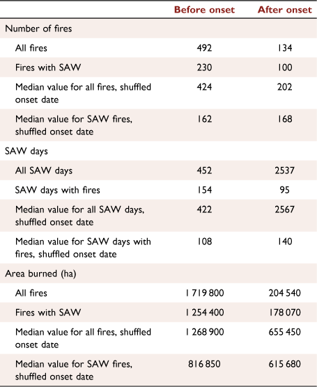
As indicated in the threshold analysis shown in Fig. 3 and detailed in Table 1, a large proportion of September–February fires across the South Coast region occurred before the 8.5 mm autumn precipitation onset. During 1948–2018, for fires that burned ≥100 ha, 492 started before onset and less than one-third as many (134) started after onset. The difference between numbers of before and after onset fire starts was particularly large for fires that burned more than 1000 ha, where more than 180 started before onset and less than 50 started after onset (Fig. 7). For fires that burned ≥10 000 ha, there were more than 7-times as many fires before than after onset.
|

|
Consistent with the contrasting numbers of fires, the total area burned from fires that started before autumn 8.5 mm precipitation onset was more than eight times greater than that from fires that started after onset (Table 1). The largest fires played a dominant role in this asymmetry – there were seven fires before precipitation onset that burned more than 40 000 ha, while there were none during the period after onset (Supplementary Material, Part IV). Area burned after onset was especially small during years whose onset date was later than median, as shown below.
These asymmetric proportions of autumn–early winter fires and area burned did not likely occur by chance, as demonstrated by the random shuffle results in Supplementary Material, Part III and their median values included in Table 1. From the random shuffle results, the median value of the ratio of area burned before vs after onset was considerably smaller than the 8.4 ratio (Table 1) that was observed, with only 1.9 times the area burned before vs after onset. The observed area burned during the period after onset was considerably lower than was obtained from the random shuffle trials. For example, 204 540 ha actually burned after autumn precipitation onset, while the random shuffle trials produced a median of 675 080 ha burned after onset, more than three times greater than observed.
Santa Ana wind associations
SAW events are a well-known driver of large autumn fires in the South Coast region (Jin et al. 2014; Keeley and Syphard 2019). The number of ≥100 ha fires that coincided with SAW days during 1948–2018, split into occurrences before and after 8.5 mm autumn precipitation onset, are shown in Table 1, Fig. 8. More than half, 330 of the 626 fires, started on or within 1 day of a SAW day. Of the 492 fires that occurred before onset, 47% started on or within 1 day of a SAW day. Of the 134 fires that occurred after onset, 75% started on or within 1 day of a SAW day.

|
The number of SAW days and the number that coincided with fires ≥100 ha provides an important perspective of the South Coast region’s exposure and vulnerability to fire weather risk. As indicated by climatological statistics (Fig. 2) and shown in Table 1, Fig. 9, the number of SAW days that occurred after 8.5 mm autumn precipitation onset greatly exceeded the number of SAW days that occurred before onset, reflecting the seasonal tendency of SAW activity through autumn toward a peak in December and January. During 1948–2018, there were 452 SAW days before and 2537 SAW days after the autumn 8.5 precipitation onset. However, despite having less than one-fifth as many SAW days before onset (Figs 8, 9, Table 1), there were 230 SAW-associated fires compared to after onset, which had only 100 such fires. 34% of the before-onset SAW days had ≥100 ha fires that started on or within 1 day of their occurrence, compared to only 4% of the after-onset SAW days. Notably, before onset, many SAW days had multiple fires while after onset only a few SAW days had multiple fires.

|
The random shuffle exercise (Supplementary Material, Part III) confirms that the number of fires and the area burned was strongly associated with SAW events, more so than expected by chance. From the 1000 random shuffle trials, high statistical significance was observed over a range of precipitation onset thresholds for fires that started before and fires that started after autumn precipitation onset.
As might be expected, fires that spread to large area burned had a strong SAW association. For all fires during 1948–2018 that burned ≥1000 ha (Table 2, Fig. 9), of those that occurred before onset, 59% started during or within 1 day of a SAW day, while 86% of those starting after onset started during or within 1 day of a SAW day. Of the 40 fires that burned 10 000 ha or more (Supplementary Material, Part IV), 37 occurred before autumn onset and 34 of them occurred during or within 1 day of SAW days. Of the largest fires, the 1970 Laguna Fire (70 482 ha), the 2003 Cedar Fire (109 545 ha), the 2007 Witch–Poomacha Fires (85 586 ha), and the 2017 Thomas Fire (114 039 ha, igniting in a particularly late-onset year), all occurred before autumn 8.5 mm precipitation onset and all occurred in association with SAW days. The latter three fires occurred in the second half of the record.

|
Discussion
Given the considerable variation in autumn precipitation onset across years and the pronounced differences in numbers of fires and area burned before and after onset, it is important to investigate fire outcomes during different types of years and across the several decades of observations.
Later vs earlier autumn precipitation onset years
When the onset of meaningful precipitation is delayed to the latter part of autumn, the higher pre-onset risk of fires that grow to larger burned area is extended, since there are more days in the year with extremely low fuel moisture after the summer drought. In contrast, when autumn precipitation onset is early, seasonal odds favour fewer SAW events early in the season so there are fewer opportunities for SAWs to coincide with an ignition and dry fuels. To quantify those tendencies, we explored the variation in fires and area burned in association with earlier and later autumn precipitation onset during 1948–2018 (Table 3).

|
There were more ≥100 ha fires (389 vs 237) and considerably more area burned (1.29 million ha vs 0.63 million ha) during later than median compared to earlier than median onset years. Onset timing did not correlate significantly (correlations having magnitudes less than 0.2) with the number of SAW days. However, as a whole (Table 3), later than median autumn 8.5 mm precipitation onset years had more SAW days than earlier than median onset years (1602 vs 1387 SAW days) within September–February.
Comparing earlier onset years and later onset years, there was an extraordinary contrast between SAW days and fires within the period from 1 September to the autumn 8.5 mm precipitation onset period (Table 3). Both earlier and later onset years had a relatively large fraction of ≥100 ha fires that coincided with SAW events within 1 day before and after, but more so in later onset years (239 of 389 fires) than earlier onset years (91 of 237 fires). Underpinning the larger numbers during the before onset period that occurred in years with later than median onset, there were more than 9 times as many SAW days (409 vs 43) and more than 5-times as many SAW days with one or more fires (130 vs 24) than occurred in the before onset period of years with earlier than median onset. As noted in Table 1, during the after-onset period, a large fraction of fires that started coincided with SAW days. Table 3 shows that this fraction was particularly high (41 of 44 fires) in the later onset years.
Recent vs earlier decades fires and related variables
Although other studies (Goss et al. 2020; Luković et al. 2021) have reported a decline in autumn precipitation in California over the last 4–6 decades, there was little change in South Coast autumn 8.5 mm precipitation onset date over the 7-decade record employed here (Fig. 4). Nonetheless, considering the unusual occurrence of large fires in California in recent decades (e.g. Goss et al. 2020), we investigate associations separately for the first (1948–1983) and second (1984–2018) halves of the record. SAW days, fires and area burned before and after 8.5 mm autumn precipitation onset for the first and second halves are compiled in Table 4.

|
Interestingly, the second half of the record showed a reduction of the total number of fires ≥100 ha, including the number of those fires that occurred before autumn 8.5 mm precipitation onset, (258 and 210, respectively, compared to those in the first half (363 and 279). However, the area burned in the second half (1.097 million ha) was considerably greater than that in the first half (0.785 million ha). The increase in area burned in the second half reflects the greater occurrence of a relatively few very large fires, as seen in Table 5 and listed in Supplementary Material, Part IV. Counting large fires shows that the second half of the record experienced 24 of 40 fires exceeding 10 000 ha, including five of seven fires exceeding 40 000 ha, and the largest fire (the 114 038 ha Thomas Fire of December 2017). Because there were more large, before-onset fires in the second half of the record, the proportion of total area burned that occurred after onset in this period was small (5.2%) compared to that (18.0%) in the first half of the record.

|
Despite greater area burned in the second half of the 71-year record, the dominance of before vs after autumn 8.5 mm precipitation onset was exhibited in both first and second halves; results were highly significant, as gaged by 1000 member random shuffle trials (Supplementary Material, Part II, Figs S.II.3, S.II.4). The difference and ratio of the number of fires before onset vs after onset that was observed was greater than or close to two standard deviations from the mean difference and ratio obtained in the random shuffle trials. In both 1948–1983 and 1984–2018 halves, the observed coincidence of fire starts and resulting area burned with SAW was highly significant, again gaged by the random shuffle trials.
Possibly contributing to the increase in area burned in the second half of the record was the afore-mentioned moderate increase in number of SAW days, amounting to about 7% greater than in the first half. Timing of precipitation onset did not change much – the mean and median autumn 8.5 mm precipitation onset dates of the first and second halves were very close, within 3 days. However, during the second half, the median before onset and during onset precipitation amounts were lower by 15–20% than those in the first half.
The increased number of SAW days and diminished precipitation in the second half of the 1948–2018 record are consistent with changes associated with increased fire activity discussed in previous studies. Williams et al. (2019), and McEvoy et al. (2020) showed that increased evaporative demand was probably involved in increasing California fire activity in recent decades. While the present study did not consider SAW intensity, Keeley et al. (2021) found a strong increase in SAW days in October and an increase in the average SAW strength in the second half of the record compared to the first. Additionally, Keeley et al. (2021) showed that the unfortunate coincidence of ignitions and strong SAW events played an important role in the second half.
Summary and conclusions
In autumn over the South Coast region of California, fire occurrence and spread is suppressed by wetting rains; however, fire risk is intensified in autumn by persistent dryness and the increasing likelihood of SAW events. Using a moderate threshold for autumn precipitation onset, defined as the first occurrence in autumn having area average precipitation ≥8.5 mm over a 3-day interval, we found that the onset timing was a strong determinant of fire activity, for fires ≥100 ha. During 1948–2018, three times more ≥100 ha fires and almost eight times more area burned before than after autumn precipitation onset. The reduction in fire activity after onset is likely due to increased fuel moisture, reinforced by other factors such as sun angle, solar radiation, fuel temperature and evaporation rates that decline in autumn. Of the largest fires that occurred in the South Coast region, nearly all occurred before 8.5 mm precipitation onset.
The autumn rainfall damping effect is underscored by the low amount of fire activity during earlier onset years compared to the high amount of fire activity during years when onset was delayed. This increase is likely because, when the onset of meaningful precipitation comes in later autumn, there are more days in the year with extremely low fuel moisture after the summer drought. In contrast, when autumn precipitation onset is early, seasonal odds favour fewer SAW events so there is a lower likelihood that a SAW event would occur together with an ignition and low fuel moisture.
There was a strong association of fire starts with SAW days, both before and after autumn precipitation onset. But large fires that started during a SAW day were much more frequent in the before precipitation onset period than after onset – more than 1 in 3 of SAW days that occurred before precipitation onset coincided with ≥100 ha fires, while less than 1 in 25 of the more numerous SAW days after onset coincided with fires. Of the 40 largest fires, 37 started before onset. And most large fires coincided with SAW days; two-thirds that started before onset and all that started after onset. Several SAW days during the before onset period experienced multiple fires. Even though the great majority of SAW days after onset did not have a fire start, most large fires that started then did so in the presence of SAW days. This indicates that in some cases, the dampening effects of prior precipitation can be overridden by the hot, dry winds to produce great flammability and fire spread.
The second half of the 71-year record suffered 1.5-times as much area burned than the first half, even though there were fewer fires that burned ≥100 ha. Although autumn precipitation onset timing did not change during 1948–2018, more autumn SAW days and the lesser amounts of precipitation before and during onset events in the second half of the record may have contributed to the increase in area burned. Also, a series of studies has emphasised the role of weather and climate patterns in causing increased wildfire risk in recent decades. McEvoy et al. (2020), Goss et al. (2020) and Zhuang et al. (2021) described an increase in summer and autumn short period extremes along with climate warming that potentially produces higher fire threat in California.
Additionally, Williams et al. (2019), Goss et al. (2020), Luković et al. (2021) and Swain (2021) described trends in observed California precipitation toward a more compressed wet season with diminished autumn precipitation since about 1960, a tendency that may be reinforced by present and future broadening of subtropical high pressure zones (Seidel et al. 2008; Johanson and Fu 2009) and by climate model projections of less frequent wet days and more dry months and years in California in response to global climate changes (Pierce et al. 2013; Polade et al. 2017; Swain 2021). A more prolonged autumn dry season bodes greater fire risk, since years with later than median precipitation onset in the historical record suffered two thirds of the total autumn–early winter area burned, with about 95% of that area burned occurring before precipitation onset.
This evidence reinforces perceptions of practitioners that certain stages of autumn, and some autumns in particular, require high levels of vigilance to help avoid fire impacts. Taking advantage of forecasts of autumn precipitation events and SAW events are crucially important in preventing large fires. Forecasts of the timing, amount and spatial extent of autumn precipitation events are vital since the degree of wetting helps to reduce risk of large fires in Southern California. Furthermore, skilful forecasts of dry conditions and how long they might persist are needed to alert fire-fighting resources and the public in avoiding and controlling ignitions. Along these lines, accurate forecasts of SAW occurrence, duration and intensity are especially needed since SAW events are so prevalent during fires that consume large areas, both before and after autumn precipitation onset. The uneven distribution of precipitation over the South Coast region, along with SAW intensity should be considered in any further analyses. Fire prone times included the very dry period before autumn precipitation onset, especially during years with delayed autumn precipitation onset. SAW events multiply fire risk, particularly before autumn precipitation onset because of very dry fuels that accumulate during this critical period, and sometimes even during the period after onset.
Supplementary material
Supplementary material is available online.
Data availability
Data on fires, weather and climate are available at the UC San Diego Library Digital Collections. https://doi.org/10.6075/J0CV4HX9.
Conflicts of interest
One author, Alexandra Syphard, is an Associate Editor of International Journal of Wildland Fire. To mitigate this potential conflict of interest she was blinded from the review process and was not involved at any stage in the editing of this manuscript. The authors declare no other conflicts of interest.
Declaration of funding
This study was supported by U.S. Geological Survey/Southwest Climate Adaptation and Science Center grants G0318P0295 to JEK and G10AP00040 to DRC; by Congressional Disaster Relief Supplemental Funding 20201120 to JEK, by the California Department of Water Resources, contract number 4600013538_ 183D5A to DRC, and by San Diego Gas and Electric support under Agreement number 5660055191 to DRC. None of these sources were involved in the preparation of the data or the manuscript.
Acknowledgements
We thank Steve Jackson for encouragement and support of this research, Richard Salmon, Michael Deflorio, David Pierce, Marty Ralph, Brian DAgostino and Ben Hatchett for helpful discussion. Two anonymous reviewers and the Editors provided useful suggestions. David Passovoy provided interpretation of FRAP fire data. Any use of trade, firm, or product names is for descriptive purposes only and does not imply endorsement by the U.S. Government.
References
Abatzoglou JT, Barbero R, Nauslar NJ (2013) Diagnosing Santa Ana winds in Southern California with synoptic-scale analysis. Weather and Forecasting 28, 704–710.| Diagnosing Santa Ana winds in Southern California with synoptic-scale analysis.Crossref | GoogleScholarGoogle Scholar |
Abatzoglou JT, Balch JK, Bradley BA, Kolden CA (2018) Human-related ignitions concurrent with high winds promote large wildfires across the USA. International Journal of Wildland Fire 27, 377–386.
| Human-related ignitions concurrent with high winds promote large wildfires across the USA.Crossref | GoogleScholarGoogle Scholar |
Abatzoglou JT, Hatchett BJ, Fox‐Hughes P, Gershunov A, Nauslar NJ (2020) Global climatology of synoptically-forced downslope winds. International Journal of Climatology 41, 31–50.
| Global climatology of synoptically-forced downslope winds.Crossref | GoogleScholarGoogle Scholar |
Bond WJ, Van Wilgen BW (2012) ‘Fire and plants. Vol. 14.’ (Springer Science & Business Media)
| Crossref |
Brown T, Leach S, Wachter B, Gardunio B (2020) The extreme 2018 northern California fire season. Bulletin of the American Meteorological Society 101, S1–S4.
| The extreme 2018 northern California fire season.Crossref | GoogleScholarGoogle Scholar |
Cayan DR, Peterson DH (1989) The influence of North Pacific atmospheric circulation on streamflow in the West. In ‘Geophysical Monograph 55: Aspects of Climate Variability in the Pacific and the Western Americas, December 1989’. (Ed. DH Peterson) pp. 375–397. (American Geophysical Union)
| Crossref |
Gershunov A, Guzman Morales J, Hatchett B, Guirguis K, Aguilera R, Shulgina T, Abatzoglou JT, Cayan D, Pierce D, Williams P, Small I, Clemesha R, Schwarz L, Benmarhnia T, Tardy A (2021) Hot and cold flavors of southern California’s Santa Ana winds: their causes, trends, and links with wildfire. Climate Dynamics 57, 2233–2248.
| Hot and cold flavors of southern California’s Santa Ana winds: their causes, trends, and links with wildfire.Crossref | GoogleScholarGoogle Scholar |
Goss M, Swain DL, Abatzoglou JT, Sarhadi A, Kolden CA, Williams AP, Diffenbaugh NS (2020) Climate change is increasing the likelihood of extreme autumn wildfire conditions across California. Environmental Research Letters 15, 094016
| Climate change is increasing the likelihood of extreme autumn wildfire conditions across California.Crossref | GoogleScholarGoogle Scholar |
Guirguis K, Gershunov A, Hatchett B, Shulgina T, DeFlorio MJ, Subramanian AC, Guzman Morales J, Aguilera R, Clemesha R, Corringham TW, Delle Monache L, Reynolds D, Tardy A, Small I, Ralph FM (2022) Winter wet–dry weather patterns driving atmospheric rivers and Santa Ana winds provide evidence for increasing wildfire hazard in California. Climate Dynamics
| Winter wet–dry weather patterns driving atmospheric rivers and Santa Ana winds provide evidence for increasing wildfire hazard in California.Crossref | GoogleScholarGoogle Scholar |
Guzman-Morales J, Gershunov A (2019) Climate change suppresses Santa Ana winds of Southern California and sharpens their seasonality. Geophysical Research Letters 46, 2772–2780.
| Climate change suppresses Santa Ana winds of Southern California and sharpens their seasonality.Crossref | GoogleScholarGoogle Scholar |
Guzman-Morales J, Gershunov A, Theiss J, Li H, Cayan D (2016) Santa Ana winds of southern California: Their climatology, extremes, and behavior spanning six and a half decades. Geophysical Research Letters 43, 2827–2834.
| Santa Ana winds of southern California: Their climatology, extremes, and behavior spanning six and a half decades.Crossref | GoogleScholarGoogle Scholar |
Hatchett BJ, Smith CM, Nauslar NJ, Kaplan ML (2018) Brief Communication: Synoptic-scale differences between Sundowner and Santa Ana wind regimes in the Santa Ynez Mountains, California. Natural Hazards and Earth System Sciences 18, 419–427.
| Brief Communication: Synoptic-scale differences between Sundowner and Santa Ana wind regimes in the Santa Ynez Mountains, California.Crossref | GoogleScholarGoogle Scholar |
Jin Y, Randerson JT, Faivre N, Capps S, Hall A, Goulden ML (2014) Contrasting controls on wildland fires in Southern California during periods with and without Santa Ana winds. Journal of Geophysical Research: Biogeosciences 119, 432–450.
| Contrasting controls on wildland fires in Southern California during periods with and without Santa Ana winds.Crossref | GoogleScholarGoogle Scholar |
Johanson CM, Fu Q (2009) Hadley cell widening: Model simulations versus observations. Journal of Climate 22, 2713–2725.
| Hadley cell widening: Model simulations versus observations.Crossref | GoogleScholarGoogle Scholar |
Jones C, Carvalho LMV, Duine G-J, Zigner K (2021) Climatology of Sundowner winds in coastal Santa Barbara, California, based on 30 yr high resolution WRF downscaling. Atmospheric Research 249, 105305
| Climatology of Sundowner winds in coastal Santa Barbara, California, based on 30 yr high resolution WRF downscaling.Crossref | GoogleScholarGoogle Scholar |
Kanamitsu M, Kanamaru H (2007) Fifty-seven-year California Reanalysis Downscaling at 10 km (CaRD10). Part I: System detail and validation with observations. Journal of Climate 20, 5553–5571.
| Fifty-seven-year California Reanalysis Downscaling at 10 km (CaRD10). Part I: System detail and validation with observations.Crossref | GoogleScholarGoogle Scholar |
Keeley JE, Syphard AD (2019) Twenty-first century California, USA, wildfires: fuel-dominated vs. wind-dominated fires. Fire Ecology 15, 24
| Twenty-first century California, USA, wildfires: fuel-dominated vs. wind-dominated fires.Crossref | GoogleScholarGoogle Scholar |
Keeley JE, Guzman-Morales J, Gershunov A, Syphard AD, Cayan D, Pierce DW, Flannigan M, Brown TJ (2021) Ignitions explain more than temperature or precipitation in driving Santa Ana wind fires. Science Advances 7, eabh2262
| Ignitions explain more than temperature or precipitation in driving Santa Ana wind fires.Crossref | GoogleScholarGoogle Scholar |
Livneh B, Bohn TJ, Pierce DW, Munoz-Arriola F, Nijssen B, Vose R, Cayan DR, Brekke L (2015) A spatially comprehensive, hydrometeorological data set for Mexico, the U.S., and Southern Canada 1950-2013. Scientific Data 2, 150042
| A spatially comprehensive, hydrometeorological data set for Mexico, the U.S., and Southern Canada 1950-2013.Crossref | GoogleScholarGoogle Scholar |
Luković J, Chiang JCH, Blagojević D, Sekulić A (2021) A later onset of the rainy season in California. Geophysical Research Letters 48, e2020GL090350
| A later onset of the rainy season in California.Crossref | GoogleScholarGoogle Scholar |
McEvoy DJ, Hobbins M, Brown TJ, VanderMolen K, Wall T, Huntington J, Svoboda M (2019) Establishing relationships between drought indices and wildfire danger outputs: A test case for the California-Nevada drought early warning system. Climate 7, 52
| Establishing relationships between drought indices and wildfire danger outputs: A test case for the California-Nevada drought early warning system.Crossref | GoogleScholarGoogle Scholar |
McEvoy DJ, Pierce DW, Kalansky JF, Cayan DR, Abatzoglou JT (2020) Projected Changes in Reference Evapotranspiration in California and Nevada: Implications for Drought and Wildland Fire Danger. Earth’s Future 8, e2020EF001736
| Projected Changes in Reference Evapotranspiration in California and Nevada: Implications for Drought and Wildland Fire Danger.Crossref | GoogleScholarGoogle Scholar |
Moritz MA, Moody TJ, Krawchuk MA, Hughes M, Hall A (2010) Spatial variation in extreme winds predicts large wildfire locations in chaparral ecosystems. Geophysical Research Letters 37, 1
| Spatial variation in extreme winds predicts large wildfire locations in chaparral ecosystems.Crossref | GoogleScholarGoogle Scholar |
Nauslar NJ, Abatzoglou JT, Marsh PT (2018) The 2017 North Bay and Southern California Fires: A case study. Fire 1, 18
| The 2017 North Bay and Southern California Fires: A case study.Crossref | GoogleScholarGoogle Scholar |
Parks SA, Parisien MA, Miller C (2012) Spatial bottom-up controls on fire likelihood vary across western North America. Ecosphere 3, 12
| Spatial bottom-up controls on fire likelihood vary across western North America.Crossref | GoogleScholarGoogle Scholar |
Pierce DW, Das T, Cayan DR, Maurer EP, Miller NL, Bao Y, Kanamitsu M, Yoshimura K, Snyder MA, Sloan LC, Franco G, Tyree M (2013) Probabilistic estimates of future changes in California temperature and precipitation using statistical and dynamical downscaling. Climate Dynamics 40, 839–856.
| Probabilistic estimates of future changes in California temperature and precipitation using statistical and dynamical downscaling.Crossref | GoogleScholarGoogle Scholar |
Polade SD, Gershunov A, Cayan DR, Dettinger MD, Pierce DW (2017) Precipitation in a warming world: Assessing projected hydro-climate changes in California and other Mediterranean climate regions. Scientific Reports 7, 10783
| Precipitation in a warming world: Assessing projected hydro-climate changes in California and other Mediterranean climate regions.Crossref | GoogleScholarGoogle Scholar |
Raphael MN (2003) The Santa Ana winds of California. Earth Interactions 7, 1–13.
| The Santa Ana winds of California.Crossref | GoogleScholarGoogle Scholar |
Rolinski T, Capps SB, Zhuang W (2019) Santa Ana winds: a descriptive climatology. Weather and Forecasting 34, 257–275.
| Santa Ana winds: a descriptive climatology.Crossref | GoogleScholarGoogle Scholar |
Seidel DJ, Fu Q, Randel WJ, Reichler TJ (2008) Widening of the tropical belt in a changing climate. Nature Geoscience 1, 21–24.
| Widening of the tropical belt in a changing climate.Crossref | GoogleScholarGoogle Scholar |
Smith CM, Hatchett BJ, Kaplan ML (2018) Characteristics of Sundowner winds near Santa Barbara, California, from a dynamically downscaled climatology: Environment and effects near the surface. Journal of Applied Meteorology and Climatology 57, 589–606.
| Characteristics of Sundowner winds near Santa Barbara, California, from a dynamically downscaled climatology: Environment and effects near the surface.Crossref | GoogleScholarGoogle Scholar |
Su L, Cao Q, Xiao M, Mocko DM, Barlage M, Li D, Peters-Lidard CD, Lettenmaier DP (2021) Drought variability over the conterminous United States for the past century. Journal of Hydrometeorology 22, 1153–1168.
| Drought variability over the conterminous United States for the past century.Crossref | GoogleScholarGoogle Scholar |
Swain DL (2021) A shorter, sharper rainy season amplifies California wildfire risk. Geophysical Research Letters 48, e2021GL092843
| A shorter, sharper rainy season amplifies California wildfire risk.Crossref | GoogleScholarGoogle Scholar |
Syphard AD, Keeley JE (2016) Historical reconstructions of California wildfires vary by data source. International Journal of Wildland Fire 25, 1221–1227.
| Historical reconstructions of California wildfires vary by data source.Crossref | GoogleScholarGoogle Scholar |
Syphard AD, Radeloff VC, Keuler NS, Taylor RS, Hawbaker TJ, Stewart SI, Clayton MK (2008) Predicting spatial patterns of fire on a southern California landscape. International Journal of Wildland Fire 17, 602–613.
| Predicting spatial patterns of fire on a southern California landscape.Crossref | GoogleScholarGoogle Scholar |
Syphard AD, Keeley JE, Pfaff AH, Ferschweiler K (2017) Human presence diminishes the importance of climate in driving fire activity across the United States. Proceedings of the National Academy of Sciences 114, 13750–13755.
| Human presence diminishes the importance of climate in driving fire activity across the United States.Crossref | GoogleScholarGoogle Scholar |
Syphard AD, Brennan TJ, Keeley JE (2019) Extent and drivers of vegetation type conversion in Southern California chaparral. Ecosphere 10, e02796
| Extent and drivers of vegetation type conversion in Southern California chaparral.Crossref | GoogleScholarGoogle Scholar |
Williams AP, Abatzoglou JT, Gershunov A, Guzman-Morales J, Bishop DA, Balch JK, Lettenmaier DP (2019) Observed impacts of anthropogenic climate change on wildfire in California. Earth’s Future 7, 892–910.
| Observed impacts of anthropogenic climate change on wildfire in California.Crossref | GoogleScholarGoogle Scholar |
Zhuang Y, Fu R, Santer BD, Dickinson RE, Hall A (2021) Quantifying contributions of natural variability and anthropogenic forcings on increased fire weather risk over the western United States. Proceedings of the National Academy of Sciences 118, e2111875118
| Quantifying contributions of natural variability and anthropogenic forcings on increased fire weather risk over the western United States.Crossref | GoogleScholarGoogle Scholar |