

Rate of spread and flaming zone velocities of surface fires from visible and thermal image processing
B. Schumacher A * , K. O. Melnik B , M. Katurji A , J. Zhang A D , V. Clifford D and H. G. Pearce C
A School of Earth and Environment, University of Canterbury, Christchurch, New Zealand.
B School of Engineering, University of Canterbury, Christchurch, New Zealand.
C Fire and Emergency New Zealand, Wellington, New Zealand.
D New Zealand Forest Research Institute (Scion), Christchurch, New Zealand.
International Journal of Wildland Fire 31(8) 759-773 https://doi.org/10.1071/WF21122
Submitted: 27 August 2021 Accepted: 8 June 2022 Published: 22 July 2022
© 2022 The Author(s) (or their employer(s)). Published by CSIRO Publishing on behalf of IAWF. This is an open access article distributed under the Creative Commons Attribution-NonCommercial-NoDerivatives 4.0 International License (CC BY-NC-ND)
Abstract
This study presents two new remote sensing approaches that can be used to derive rate of spread and flaming zone velocities of a wildfire at very high spatiotemporal resolution. Time sequential image tracking from thermal or visible video collected on uncrewed aerial vehicles is used to estimate instantaneous spatial rate of spread of a surface fire. The techniques were developed using experimental wheat‐stubble burns carried out near Darfield, New Zealand, in March 2019. The thermal tracking technique is based on Thermal Image Velocimetry, which tracks evolving temperature patterns within an infrared video. The visible tracking technique uses colour thresholding, and tracks fire perimeter progression through time at pixel resolution. Results show that the visible perimeter tracking creates a higher mean rate of spread compared to thermal image velocimetry. The visible perimeter tracking provides rate of spread measurements for fire front progression whereas the thermal tracking techniqueis computationally more expensive, but can resolve velocities of thermal structures within the flaming zone and provides spatiotemporal rate of spread measurements. Both techniques are available as open‐source code and providevital scientific data for new studies concerning e.g. fire–atmospheric interactions or model validation. They may be adapted for operational purposes providing rate of spread at high spatiotemporal resolution.
Keywords: Adaptive thermal image velocimetry, fire rate of spread, image velocimetry, perimeter tracking, ROS, thermal imagery, uncrewed aerial vehicles, wildfire.
Introduction
Wildfires have become an increasing global problem over the last two decades, causing severe damage to human infrastructure and the environment and resulting in rising numbers of evacuations (Beverly and Bothwell 2011; Zhuang et al. 2017; McCaffrey et al. 2018; McNamee et al. 2019; Wong et al. 2020). Shrub and grass surface fires are dangerous because they have the ability to spread extremely fast and respond to changing weather conditions (Clements et al. 2007; Cheney and Sullivan 2008). The risk of wildfires is increasing, especially in areas with large contiguous grasslands and during dry periods with recurring dry wind conditions (Littell et al. 2009). Therefore, more accurate aerial observations of spatial fire behaviour are becoming crucial to advise fire management agencies for operational purposes and to gain more detailed scientific knowledge about the drivers of wildland fires (Mell et al. 2009; Tymstra et al. 2010).
The rate of spread (ROS) of wildfires is an important parameter for firefighting operations that allows risk assessment, facilitates the development of appropriate strategies and tactics, and provides validation of fire-spread models and a diagnostic proxy for fire–atmosphere interactions (Plucinski et al. 2017; Stow et al. 2019). Many studies have attempted to quantify fire ROS using remote sensing data. Spatial ROS observations on a time scale of hours to days for large fires (>100 ha) are normally achieved using visible and Long-Wave thermal Infrared Radiation (LWIR) satellite imagery of wildfires (Liu et al. 2018). Studies employing hovering helicopters have used either multispectral or LWIR imagery to calculate ROS using image segmentation techniques to identify fire perimeters and their progression (Ononye et al. 2007; Paugam et al. 2013; Vivo et al. 2021).
In highly controlled environments like laboratories or during light fuel prescribed burns, ROS is commonly estimated using projected isochrones obtained from visible images or on the lag-correlation of temperature point measurements (Cheney and Gould 1995; Finney et al. 2010; Gould et al. 2017; Johnston et al. 2018). Abouali and Viegas (2019) presented a tool for ROS calculation in a laboratory setting; however, the user needs to specify the expected direction of fire spread and only one ROS value per image is calculated. Non-linear fire behaviour, resulting from atmospheric turbulence and fuel variability, requires spatially and temporally continuous measurement of ROS. This makes instantaneous spatial ROS essential for understanding rapid changes related to the three major drivers of the fire: fuel, topography and atmospheric forcings.
Past aerial imaging techniques for ROS retrieval lacked sufficient spatial or temporal resolution for scientific purposes such as the analysis of atmospheric forcings influencing the fire on a small temporal (sub-second) and spatial scale (<10 m) (Ononye et al. 2007; Stow et al. 2014). Additionally, the current available algorithms for ROS retrieval require either predefined ROS directions or extra parameters such as temperature thresholds to run (Paugam et al. 2013; Valero et al. 2018; Abouali and Viegas 2019; Moran et al. 2019). Uncrewed Aerial Vehicle (UAV) systems capable of acquiring near-target aerial video of fires have only become operational within the last few years. Johnston et al. (2018) give a detailed overview of the methods and data processing approaches available, as well as the influence on the results when applying the algorithms to thermal or visible imagery. The thermal technique from Paugam et al. (2013) is identified as most suitable by Johnston et al. (2018) for retrieving correct ROS estimations, but requires a temperature threshold for the calculation. This threshold needs to adapt for each acquisition separately, which provides extra uncertainties due to the interactions of the fire with its environment such as fuel or atmospheric conditions. Recent developments in the field point out that especially high-resolution UAV-based ROS is becoming a key input for better fire propagation predictions (Akhloufi et al. 2021).
Alongside the ROS parameter, the flaming zone dynamics are a substantial part of the fire spread, expressing the interactions of the atmosphere with the fire. Finney et al. (2013, 2015) reported that knowledge on the dynamics of the flaming zone is essential for the development of physical fire spread models. Additionally, the flaming zone dynamics and the resulting instantaneous ROS are strongly influenced by the atmospheric conditions (Sun et al. 2009).
The current research is a progression of the pilot study previously presented using the same algorithms and data (Schumacher et al. 2021). It introduces Thermal Image Velocimetry (TIV), an image tracking technique to measure spatial thermal pattern velocities, incorporating the dynamics and the atmospheric forcings of the fire's flaming zone. The TIV approach enables studying fire–fuel–atmosphere interactions in rapidly changing fire environments, specifically in the flaming zone based on thermal video. The spatial flaming zone velocities from TIV deliver multiple instantaneous fire velocities at any certain point over time. Hence, the measurement is not directly comparable with any available ROS measurement and an extraction of the fire front called Fire Front Line (FFL) is introduced alongside and compared with the ROS from the Visible Fire Perimeter Tracking (VFPT) algorithm. The VFPT ensures an instantaneous ROS measurement from visible-spectrum video. The algorithms are tested, verified and compared using footage acquired from experimental fires.
The research objectives were:
To build two open-source algorithms that calculate instantaneous ROS of fast-spreading wildfires at a high spatial resolution;
To demonstrate the relationship between flaming zone velocity and the calculated ROS;
To compare the results of the two algorithms and discuss how each contributes to various operational and scientific objectives.
Methodology
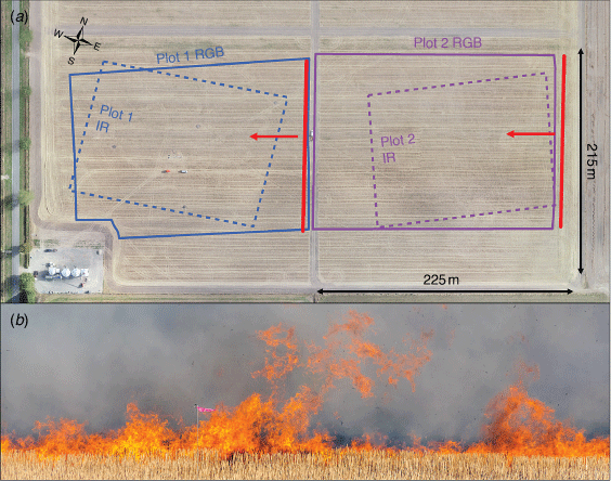
The thermal and visible video was collected from fires in two experimental burn plots during a field experiment near Darfield, New Zealand, in March 2019, with the location, fuel type and meteorological conditions similar to the 2018 field campaign described by Finney et al. (2018). Four 200 × 200 m plots were laid out in a harvested wheat field containing short stubble (20 cm height) as fuel, of which two were used in the research presented here (Fig. 1). The fires were ignited along a straight line at the north-eastern edge at 4:02 pm (Plot 1) and 5:46 pm New Zealand Daylight Time (NZDT) (Plot 2) and spread in a south-westerly direction. Active fire spread continued for 6:03 and 7:05 min respectively before the flames reached the edge of a fire break zone defined as the end of the burn plot.
|
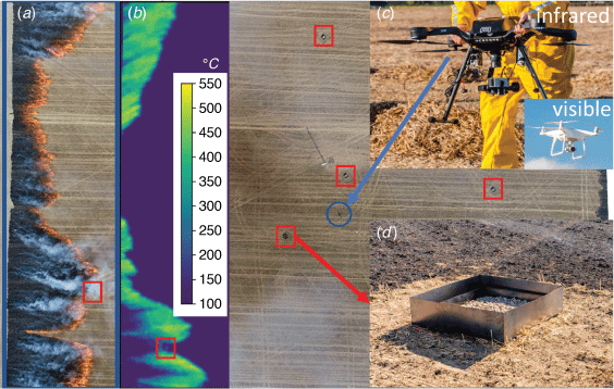
The visible and infrared cameras were mounted on two separate UAVs. The visible camera captured video from 200 m above ground level at 25 frames s–1 (fps) and the infrared camera was at 120 m above ground level operating at 27 fps. The spatial pixel resolution of the infrared video was 0.45 and 0.13 m of the visible video. Hot charcoal boxes were installed in the plots to enable image stabilisation using post-processing software for the infrared imagery (Fig. 2). The visible imagery was stabilised using visually distinctive features outside the plot such as structures, equipment and distinctive patches of vegetation. The software stabilisation was accomplished using Blender, an open-source software package widely used in research (Cardona and Hartenstein 2006; Ramos et al. 2011; Blender Online Community 2019). A detailed description of the stabilisation process is available in Schumacher et al. (2019). To avoid noise in the output datasets and to allow the fire to progress over at least one pixel, the thermal and the visible videos were averaged to 3 fps for the analysis.
|
The weather conditions on the day of the experiment were clear skies with a 10-min average air temperature of 18.2°C during the experiments. The 10-min average wind speed at 2 m height during the burns was 4.4 m s–1 for Plot 1 and 3.6 m s–1 for Plot 2 measured by a weather station located 70 m south of Plot 2. The wind direction during both experiments was steady and from the east–northeast sector.
Thermal Image Velocimetry
TIV is a method introduced by Inagaki et al. (2013) that retrieves the velocity of temperature patterns detected from spatiotemporal analysis of brightness temperature perturbations in the field of view of a thermal camera. The technique was originally developed to examine spatial atmosphere–surface interactions and visualisation of near-surface wind velocities (Inagaki et al. 2013; Schumacher et al. 2019). TIV is based on Particle Image Velocimetry (PIV) techniques and uses image correlation of two time-sequential images to estimate velocity vectors. The fundamental idea behind this approach is that certain patterns (in this study fire patterns) within the thermal video move as coherent structures and can therefore be tracked and the movement can be quantified with a window correlation approach. The process is visualised in Fig. 3 and can be explained as follows:
Two images are extracted from the stabilised brightness temperature video (in this study: Image T0 and Image T0 + 1 s).
An interrogation window of a predefined size is established in Image T0. A search area of a predefined size is set around the area of the interrogation window in image T0 + 1 s.
Moving windows of the same size as the interrogation window are extracted from the search area in Image T0 + 1 s.
Each moving window is correlated with the interrogation window and a correlation map is derived. The vector is estimated by analysing the correlation map and finding the subpixel peak position of the highest value.
Steps 2–4 are repeated for all pixels in the currently extracted images, then Steps 1–4 are repeated for the next image pair.

|
The interrogation window size of the TIV algorithm is a key input parameter to define shape and size of the tracked velocities. It was set to the size of 16 by 16 pixels, which was previously found to be most successful (Schumacher et al. 2019).
The fire TIV algorithm and calculation are based on a modified version of the A-TIV algorithm (Schumacher 2021). For the present study, the technique was adapted to work with the high fluctuations in the thermal imagery of the fire. This allowed the direct application of the TIV algorithm to the brightness temperature values from the stabilised thermal imagery (see Fig. 4), unlike the usual application to temperature perturbations. Some pre-processing and specific settings were required for a successful TIV calculation. Firstly, to avoid erroneous calculations behind the flaming zone in smouldering fuel, all sections with constant temperature within the interrogation windows were excluded from the calculation. Secondly, to avoid error vectors in the smouldering fuel behind the fire, all interrogation windows with a low standard deviation (<15°C) were excluded from the calculation. Thirdly, in the post-processing, the fire TIV involved an additional outlier removal process. Vectors larger or smaller than 2 s.d. of the mean in a proximity of eight pixels were considered as outliers and substituted with the mean vector of the proximity.

|
The fire TIV algorithm does not retrieve ROS directly, but rather provides a combined measurement of the fire front progression and the movements within the flaming zone directly adjacent to the fire front. In this study, we refer to this combined measurement as the flaming zone velocity. The flaming zone velocity was analysed using three basic statistical measures applied to the spatially measured velocities over the time dimension: standard deviation, mean and maximum. These metrics allow us to draw basic conclusions about the flaming zone characteristics.
Visible Fire Perimeter Tracking
The VFPT algorithm was inspired by a technique described by Moran et al. (2019) that derives ROS from a series of fire perimeters taken at different times that form a ‘progression raster’ (isochrone extractions) – an image containing incremental additions to the burnt area from each timestamp. This technique was modified to measure pixel-wise ROS directly from the progression raster, without converting it to polygons and smoothing the polygons or changing the output resolution, ensuring all spatial data are preserved as much as possible. Colour thresholds based on the hue, saturation and value (HSV) colour model were developed with specific attention to the ignition of the respective pixel and applied to the stabilised visible footage to separate burnt and flaming areas (collectively referred to as ‘fire-affected areas’) from unburnt fuel. Each plot had a custom, manually defined HSV threshold that allowed the optimal identification of fire-affected areas in each frame of the video. The fire-affected areas from consecutive images were subtracted to determine the new addition to the fire area during each given video frame. Additions from all frames were combined into one image to form a progression raster showing at which timestamp each pixel transitioned from unburnt to fire-affected. The rest of the analysis was performed on this single progression raster (top-right in Fig. 4).
The calculation of the VFPT is realised with the following procedure (bottom row in Fig. 4):
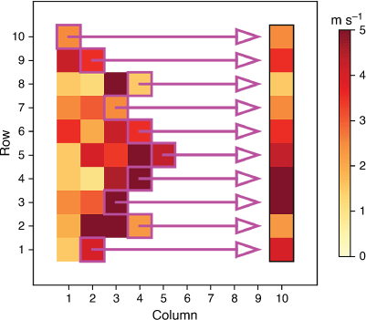
A 41 × 41 pixel moving window is established across the progression raster. As the window moves, each pixel of the progression raster takes turns serving as the pixel of interest, located in the centre of the moving window. If the pixel of interest is located close to the edge of the progression raster, the missing pixels in the moving window are filled with null values.
Within the examined window only, the timestamps directly before or directly after the centre pixel timestamp are retained. If no timestamp is immediately before or after the centre pixel's timestamp, the smallest absolute time difference between the centre timestamp and the surrounding timestamps is identified and only the pixels with timestamps within that time difference are retained.
The ROS vector for the pixel of interest is calculated by taking the average of all vectors leading from the pixels marked with the previous timestamp to the centre pixel, and proceeding from the centre pixel towards the pixels marked with the next timestamp.
The window moves over so that the next pixel of the progression raster is located in its centre, and Steps 2–3 are repeated until the rate and direction of fire spread are calculated for each pixel in the progression raster.
The fundamental idea behind this procedure is that any pixel of interest may be ignited by any surrounding pixel that burnt in the timestamp before. Additionally, the pixel of interest may also serve as the driver for the surrounding pixels that are burnt in the next timestamp. This idea was first introduced by Moran et al. (2019) and connected to an edge detection algorithm that was substituted for the presented VFPT technique by a colour tresholding technique.
Fire Front Line
Owing to the combined measurement of the flaming zone velocity images over time, an additional edge detection is needed to derive the fire front from the TIV output. In this study, the fire front extraction from TIV or from VFPT is called the FFL, a 2-dimensional (time–space) measurement enabling continuous underlying conditions of the fire front at a certain place or instantaneous forcings to the entire fire front at a certain time to be shown. This extraction is necessary for calculating instantaneous ROS from the TIV flaming zone velocity.
The fundamental idea of the FFL is to reduce dimensions specifically in the TIV output that provides continuous 2-dimensional flaming zone velocity over time (Table 1). To obtain ROS from this output, a dimension reduction is necessary. Therefore, the following approach is proposed: the fire front is the leading edge of the fire perimeter. The FFL derived from TIV means that the fire front is the momentary edge of the flaming zone in the direction of progression. The outer edge of the fire front was extracted from each flaming zone velocity image over time by searching in each row along the image-oriented y-axis, which is positioned along the ignition line, for the first value of the progressing fire. This value represents the front of the flaming zone in each row and at each timestamp and, when displayed as a line over time, enables visualising effects that happen at the same time to the whole fire front or continuously over time at a certain place (Fig. 5). This representation is particularly helpful for determining the temporal one-dimensional ROS of the entire fire front at any given time using the TIV flaming zone velocity. The extracted FFL is averaged over the remaining spatial dimension to derive instantaneous ROS over time.

|
|
The representation of ROS from the VFPT method is substantially different from the TIV flaming zone velocities. ROS is directly represented instead of velocities; however, by exchanging the time dimension with the space dimension (x-axis), a similar FFL extraction can be achieved. The rows of the ROS array remain whereas the timestamps are shifted to the x-axis (columns). The FFL constructed from the VFPT output occasionally results in null values, because the ROS is calculated for each pixel only once and therefore is only available when the fire progresses forward between two frames.
As the methodologies for TIV and VFPT differ substantially and the results display different information, the comparison was realised with the average of the FFL over time, representing each a 1-dimensional temporal ROS measurement for the entire fire front at any certain time. A comparison of all parameters derived from TIV and VFPT is available in Table 1. VFPT results were adjusted and downsampled to match the rotation, extent and resolution of TIV results with a nearest-neighbour interpolation. Both results were then transformed from image-based coordinates to geographic coordinates to ensure a correct ROS comparison. Finally, both temporal ROS values were compared using a histogram plot emphasising differences and similarities. Various features of the fire visible from both methods will be discussed to show the advantages and disadvantages of each method.
The FFL edge detection is comparable with previous studies that detect the edge of the flaming zone based on its brightness temperature (Paugam et al. 2013; Johnston et al. 2018). The FFL could be reproduced from the brightness temperature-based edge detection as well because the FFL in detail is a change of dimensions and therefore setting a different viewpoint on the ROS data. The advantage is that FFL can straighten the fire front and visualise fuel–fire and atmospheric–fire interactions.
Flaming depth and residence time
The flaming depth and the residence time of both fires were calculated using the thermal imagery. The residence time per pixel was defined according to previous studies as the time period when temperatures exceeded 300°C (Wotton et al. 2011). The flaming depth was measured as the depth of the flaming zone that exceeded 300°C parallel to the fire spread direction. Both measures were then averaged over 1-min intervals and created a good estimate of local spread rates (Johnston et al. 2017).
Results
Flaming zone velocity from Thermal Image Velocimetry
The flaming zone velocity calculated using TIV produces pixel-resolved velocity values for the flaming zone over time. This means that a pixel, unlike in the VFPT algorithm, can display multiple velocity values over time because the TIV actually tracks any movement within the thermal video. However, before the application of the algorithm, this was restricted to areas that effectively show temperature changes and are accordingly most likely to happen in the flaming zone (see Section Thermal Image Velocimetry). Therefore, the mean of the TIV output displays the average progression of the fire within the flaming zone for every particular location. The standard deviation calculated over time indicates the level of fluctuation associated with the flaming zone. The maximum flaming zone velocity represents the highest flaming zone velocity at a given pixel (Fig. 6).

|
Spatial rate of spread from Visible Fire Perimeter Tracking
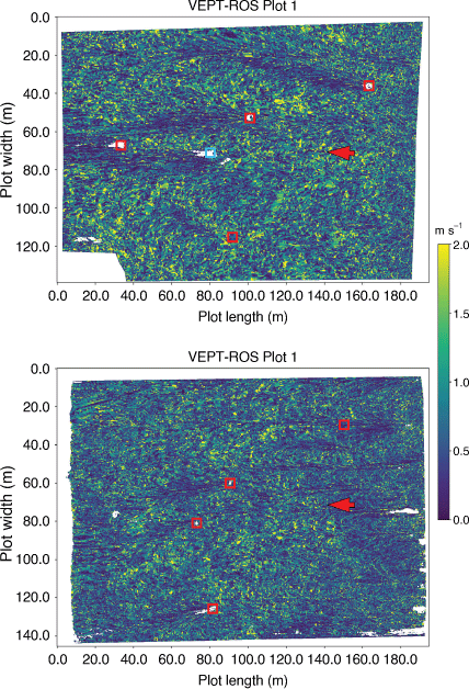
The VFPT technique produces a three-layer output array, with the first layer containing all spatial ROS values, the second layer containing the directions of fire spread, and the third the progression timestamps of when the pixels transitioned from unburnt to fire-affected. Visual examination of ROS produced by this method shows that the fire spread varied with the distance from the ignition line and the location in the plot (see Fig. 7). For both plots, ROS was slow near the ignition line (<0.5 m s–1) and increased for the first 30–50 m, after which it reached a constant rate (0.75–1.0 m s–1). A lot of variability is evident across the plots, with the ROS likely affected by the conditions at a given location in the plot. The ROS output shows wave-like patterns that are smaller in amplitude close to the ignition line and increase in size towards the end of the plot (see Fig. 7).
|
White areas in the ROS image indicate areas marked as not fire-affected by the algorithm. In most cases, the hot charcoal boxes were located in these areas, and caused areas of slower or no burning in the lee of these boxes. Occasionally, pixels that were burnt in reality were not marked as such by the colour thresholding algorithm used, e.g. small clusters of empty pixels throughout the image.
Fire Front Line
The FFL, which is a parameter derived for each of the TIV and VFPT methods, shows the fire front velocity along the plot width at a given time. Especially in the TIV extraction (TIV-FFL), for Plot 1 there is a clear increase by 0.2 m s–1 on average from the previous signal in the ROS of the whole fire front at 235 s (see red rectangle for Plot 1(a) in Fig. 8). Plot 2 shows the impact of fuel structure on the FFL parameter, especially in the beginning of the experiment, with a sustained progression over time in certain rows (see red rectangle for Plot 2(c) in Fig. 8). Based on the visible footage, this effect may be associated with poor fuel continuity, patches of green vegetation diverting the fire and patches of stubble catching fire more readily than others during ignition. However, an in-depth analysis is not available in this study owing to the lack of detailed fuel data. The TIV version of the FFL is limited to the field of view of the infrared camera showing a width of 125 m for Plot 1 and 100 m for Plot 2.

|
The TIV method produced an FFL without missing values, because the measurement of ROS for every frame of the video ensured that there is a value for each time–plot row combination. This created an FFL that is available over the entire time of the burn and represents the dynamic motion of the fire within its frontal flame zone. In contrast, the FFL velocity matrix extracted from the VFPT (VFPT-FFL) cannot resolve a ROS value for the entire width of the plots at every timestamp owing to the binary decision of a pixel being marked burnt or unburnt in the VFPT-FFL. Therefore, the calculation of the VFPT-FFL introduced null values (indicated by white space) where no fire progression at the front was determined by the VFPT method. This effect can be visually distracting, but the FFL obtained from the VFPT output can still serve as a tool for identifying patterns.
The FFL figures for both extraction methods show both streamwise and spanwise structures. The spanwise structures indicate that the fire has a constant ROS over the length of the fire front. This is especially highlighted in Plot 1 of the TIV-FFL (Fig. 8a). This certain event at 235 s is not shown by the VFPT-FFL method owing to the low density of velocity estimates. However, streamwise structures that can be seen in Plot 2 of the TIV-FFL (Fig. 8b) and indicate a certain similarity of the fire over time are also visible in the VFPT-FFL (Fig. 8d).
Comparison of temporal ROS and flaming depth and residence time
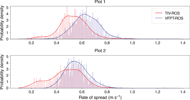
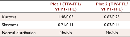
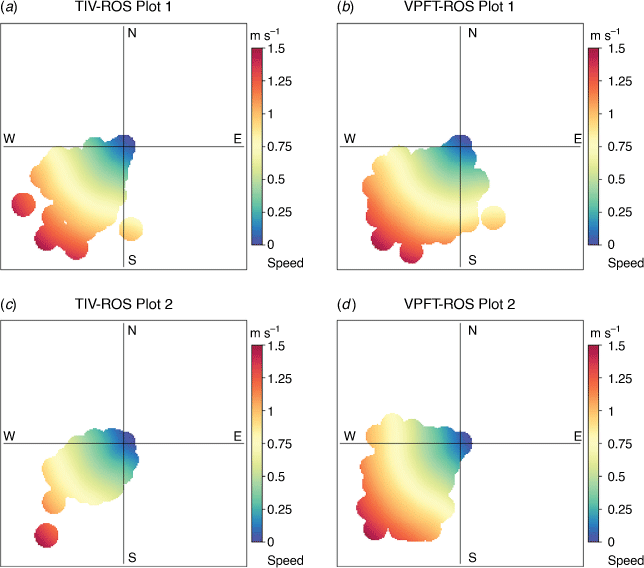
For comparison, the harmonic mean of the FFL velocities over time for both methods and for both burn plots was calculated based on the extent of the TIV-FFL (Fig. 8). Additionally, the comparison was shortened to 366 s for Plot 1 and 400 s for Plot 2 owing to the smaller field of view of the IR camera. The width of the FFL means was reduced by 5 m owing to corner effects and mismatching extents. Overall the VFPT-FFL shows a higher average ROS of 0.63 m s–1 for Plot 1 (0.56 m s–1 for Plot 2) compared with the TIV-FFL average of 0.50 m s–1 (0.43 m s–1 for Plot 2) (Fig. 9). The overall average ROS from manual records was 0.56 m s–1 (203 m in 6 min and 3 s) for Plot 1 and 0.49 m s–1 (208 m in 7 min and 5 s) for Plot 2. This is in line with the findings of Johnston et al. (2018) who showed via an extensive analysis of different ROS approaches from thermal and visible imagery that each technique will measure a slightly different ROS owing to the challenges associated with the determination of the position of the fire front. In their study, the visible approach from a side view measured a higher ROS and the thermal approach based on Paugam et al. (2013) produced a lower ROS compared with the overall mean of the eight approaches tested. Both of the ROS distributions obtained from Plot 1 are similarly positively skewed; however, the kurtosis of the TIV-FFL distribution is higher than the kurtosis of the VFPT-FFL. This can be attributed to the high decrease in probability density at ~0.4 m s–1 (Fig. 9). The skewness and kurtosis values of the temporal ROS distributions for Plot 2 show a similar result (Table 2). The direction and speed of the ROS are shown in Fig. 10. Especially in Plot 2, a higher westerly component of the VFPT is evident. The directions of higher velocities retrieved from both algorithms match better compared with a larger scattering of lower velocities.
|
|
|
Flaming depth and residence time were extracted from the thermal imagery with a threshold of 300°C (Section Flaming depth and residence time). Table 3 gives an overview of the flaming zone characteristics as well as the estimated ROS that results from these measures.

|
Discussion
Visible versus thermal imagery
The videos were collected during the experimental burns using two UAVs flying at heights of 200 m (visible) and 120 m (infrared). The advantage of using visible-spectrum footage is the higher available resolution of 0.13 m (versus 0.45 m for the IR camera), the lower cost, the wide availability of such camera equipment in the operational world, and its versatility and small size and weight (Akhloufi et al. 2021). The disadvantage of visible-spectrum footage is that no temperatures are associated with the imagery, which makes it very challenging to resolve flaming zone processes within the fire front revealed by infrared cameras. Differentiating fire-affected areas from unburnt fuel is also more difficult in visible-spectrum footage owing to the presence of smoke, and, therefore, the colour value threshold is not necessarily an optimal indicator of burning and burnt areas.
The inability of visible imagery to detect newly burnt areas owing to the presence of smoke can lead to underestimation of ROS while the newly burnt pixel is obscured, and overestimation of ROS when the pixel becomes visible again. Various possible image exposures, relative angles to the sun, fuel types and reflectance of the ground surface affect the colour of the image, meaning that colour thresholds have to be defined for each fire separately in order to produce reliable results. For instance, a particular shade of yellow stubble can be very similar to parts of the flaming front, and dark shadows in unburnt fuels can be similar to already burnt areas. Consequently, the user has to carefully select colour thresholds that will maximise the correct detection of fire-affected areas. This step increases the amount of manual pre-processing required from the user, and in the future, it would be beneficial to replace the semi-automatic thresholding approach with a robust machine learning algorithm for outlining the fire perimeter.
Thermal imagery has the advantage of associated brightness temperatures and less smoke interference at the fire front. However, the spatial resolution of thermal infrared imagery is low compared with existing visible-spectrum cameras. This is due to the physical property of infrared light carrying less energy than visible light. Therefore, infrared camera sensors will contain fewer pixels than a visible camera, resulting in lower-resolution images. This implies that the UAV flight height is limited to the range that allows thermal cameras to resolve temperatures within the fire while still attempting to maximise the field of view. Actively cooled cameras can partially solve this problem; however, they cannot be fitted onto UAVs owing to their large size and weight and would instead require a helicopter-based system.
The use of airborne thermal imagery for fire progression and the estimation of ROS is not new (Stow et al. 2019). Additionally, thermal imagery plays a major role in the operational detection of remaining fire hotspots (Wardihani et al. 2018; Akhloufi et al. 2021). This allows further use of thermal imagery in estimation of fire spread, possibly alongside TIV as tracking algorithm.
When using UAVs, footage stabilisation is essential but a non-trivial process. Image stabilisation was undertaken successfully in this study and removed any motion from the cameras, but it is recommended future algorithm users pay close attention to this step and carefully consider the type and location of the hot reference targets. An alternative technique to stabilise thermal imagery of wildfires is presented by Valero et al. (2021), which includes a feature detection algorithm; however, interference introduced by large camera movements or other moving objects can still have a negative impact on the image stabilisation and registration.
Flaming depth and residence time calculated from the thermal imagery estimate a local ROS value that is on average similar to the ROS means calculated from the TIV measurement. ROS calculated from flaming depth and residence time slowly increases until minute 4–5 in both plots and then decreases, which is matches the TIV-FFL calculation in Fig. 8.
Visible Fire Perimeter Tracking versus Thermal Image Velocimetry
In this study, the fire perimeter tracking method was used to analyse visible imagery only; however, the approach can also be easily applied to infrared footage, using temperature values instead of HSV colour values for extracting fire-affected areas to form the progression raster. Because visible-spectrum imagery does not have temperature values assigned to each pixel, extracting fire-affected areas from visible imagery had to be performed using HSV values instead. The VFPT approach classifies a pixel as fire-affected as soon as the HSV colour threshold is reached, even if in reality the flame only momentarily covered the area of interest and retreated leaving the fuel unburned. This problem is addressed by converting the original 25 fps footage to 3 fps to minimise the flame tilting effects. Additionally, the HSV thresholds were carefully chosen to minimise false-positive identifications of fire-affected areas. The idea was that if a fire-affected pixel did not get detected in the current frame, it would be identified in one of the subsequent frames, introducing only a small error to the timing of its ignition. However, if an unaffected pixel is falsely registered as fire-affected, it will introduce significant noise to the resulting fire-progression raster and can substantially increase error in the calculated ROS. On the edges of the plots, the VFPT algorithm on some occasions identified previously burnt fire breaks as fire-affected areas, which led to a higher number of error vectors in this area. In order to remove this noise, the VFPT spatial ROS was clipped to the extent of the experimental plot. The size of the VFPT moving window (41 × 41 pixels) was picked based on an estimate of the radiative pre-heating extent (~2 m), which directly affects the fire spread. Moreover, the maximum ROS should also be covered by the moving window.
The VFPT-FFL is not an optimal measure to extract space–time continuous flaming zone velocity owing to its binary decision of marking a pixel as burnt or unburnt whereas the TIV-FFL may be able to extract multiple ROS values for each pixel while the flaming zone progresses.
In contrast to the VFPT, the TIV is not a perimeter tracking technique in the first place and therefore mostly displays the momentary movements of the entire flaming zone including flames and hot air parcels. This makes the TIV flaming zone velocity ideal to analyse flaming zone dynamics occurring behind the fire front, especially in connection with the atmospheric forcings driving the fire. The information gained can further help to understand dynamics of fire–atmosphere interactions. A small example of this is the enhanced progression at 235 s in the TIV-FFL of Plot 1 (Fig. 8a). However, owing to a lack of high-frequency wind velocity measurements, a further assessment of this structure is not possible.
In a field campaign conducted in 2018 that was similar to the one presented in the current study, TIV proved to be a useful tool to derive turbulent fire advection velocities that matched well with wind velocity patterns. The narrow field of view of the camera with a higher resolution is also capable of resolving smaller structures within the flaming zone (Katurji et al. 2021). The statistical metrics (maximum, mean and standard deviation) of the TIV output display the progression of the flaming zone and potentially smouldering behind the fire front. This is especially dependent on the input parameters of the TIV algorithm defining the amount of filtering of the brightness temperatures from the thermal imagery behind the flaming zone. However, with adaptations in the post-processing of the flaming zone velocity, or with the VFPT method applied to the thermal video, perimeter tracking similar to the presented VFPT could be accomplished for the thermal imagery. Additionally, the threshold value of the VFPT also requires an informed user to adjust the parameters to obtain accurate results.
The comparison between TIV-FFL and the TIV flaming zone velocity also demonstrates the relationship between flaming zone velocities and the calculated ROS. Whereas the mean of the entire flaming zone progression is low (approximately 0.1 m s–1) owing to smouldering effects in the back of the flaming zone, the maximum can reach 2.2 m s–1. However, the TIV-FFL ranges below 1.8 m s–1, which means that the highest flaming zone velocities do not contribute to the fire front. This means that flaming zone coherent motions can reach higher velocities than the measured ROS at the fire front. This is specifically significant for studying fire–atmospheric interactions, which are related to other factors in addition to the fire front and its ROS.
TIV enables scientists to explore the spatial statistics of flaming zone velocities and the flaming zone kinematics, contributing to our understanding of fire spread dynamics. As shown in this study, the extraction of the fire front can lead to detailed insights connected to fuel characteristics and atmospheric forcings influencing wildfires. The TIV technique with additional FFL extraction is more accurate in deriving ROS compared with the VFPT method owing to the known differences in the estimation of the flaming front (Johnston et al. 2018).
Both methodologies imply certain limitations such as the relatively low resolution of the thermal imagery compared with the higher resolution of the visible imagery. This also has implications on the flight height of the drone. Also, the resolved temperature of the thermal imagery is impacted by the flight height and resolution of the thermal imager because of the indirect averaging effect of the pixel size. Specifically, TIV is dependent on coherent motions of the flaming zone and therefore involves higher spatial resolution than the VFPT technique.
The VFPT technique is limited when displaying the dynamics of the flaming zone and displays the overall motion of a certain predefined window. Therefore, it is not capable of displaying flaming zone dynamics. Furthermore, it currently requires predefined parameters such as a colour value threshold to run, which will need further investigation in the future to allow automated retrieval of ROS.
Applications
The possible applications of the two presented algorithms can extend from determining fire spread for operational firefighting purposes to fire behaviour analysis and modelling. The ROS output from the TIV and VFPT methods can potentially form validation datasets for predictive fire spread models e.g. Forestry Canada (1992), Rothermel (1972), which underpin fire growth prediction tools such as Farsite, Prometheus or the Wildland Urban Interface Fire Dynamics Simulator (Finney 1998; Mell et al. 2009; Tymstra et al. 2010). Additionally, instantaneous ROS in particular can be adopted into existing frameworks such as the Kalman filter-based methodology of Lin et al. (2019) and Rochoux et al. (2015) to improve the wildfire progression forecasts for firefighting. Akhloufi et al. (2021) describes more of these fire monitoring, detection and management strategies in which TIV and VFPT methods could be integrated, either as validation data or as operational tools. The challenges remain for large fires that exceed the field of view of the cameras. New approaches using multiple drones similarly to Viseras et al. (2021) or other airborne systems (e.g. helicopters) have to be tested before being implemented operationally.
Conclusion and outlook
In this study, we present two newly developed algorithms to retrieve and analyse the instantaneous spatial ROS of fast-spreading fires. The first algorithm uses visible spectrum video of the fire and a perimeter-tracking methodology to estimate the instantaneous ROS. The second uses infrared video and subsequent TIV technique to track the fire evolution. This can be used to estimate spatial ROS; however, the output of TIV is more focused on the dynamics of the flaming zone and therefore the interaction of the atmosphere with the fire. When compared, the TIV method produces on average 0.1 m s–1 slower spread rates compared with VFPT. In the future, imagery obtained from more experimental burns in wheat stubble and gorse scrub fires will be used to further verify and test both techniques; however, smoke interference may become a greater issue in other fuel types, which could mean a lower signal-to-noise ratio for both visible and thermal imagery. Overall, both algorithms provide new spatiotemporal estimates of ROS for fast-spreading fires that may be useful for firefighters, fire scientists and fire modellers. Both algorithms are open-source and available on github with brief examples from the presented data (Melnik 2021; Schumacher 2021). In particular, the VFPT, which uses visible video imagery, is a good measure for operational ROS quantification, as it provides information at the flaming front, indicating how fast the fire is expanding and in what direction. Utilising this information in a fire behaviour model can yield valuable insights into the most likely trajectory of the fire, and therefore appropriate firefighting techniques and assets most at risk. The TIV infrared imagery method can further help scientists to understand flaming zone dynamics specifically connected with atmospheric measurements to evaluate fire–atmospheric interactions.
Data availability
The data used in this manuscript are available for public within the open-source repositories provided with Schumacher (2021), Melnik (2021). Any additional data are also linked to the repositories and available for download.
Conflicts of interest
The authors declare no conflicts of interest.
Declaration of funding
This research was co-funded by the Ministry of Business, Innovation and Employment (MBIE), New Zealand, grant number C04X1603 entitled ‘Preparing New Zealand for Extreme Fire’ and by the Royal Society of New Zealand grant number RDF-UOC1701.
Acknowledgements
We would like to thank all field support teams including technical and general staff, the High Country Fire Team and the local landowner Andy Gillanders. In particular, we would like to acknowledge the very thoughtful, well-organised and proactive support we received from all the members of the volunteer fire crew. The success of our experiments and the safety of our science team can be attributed in part to our research design, but also significantly to the safe and well-executed operations that the fire crew conducted. A special thanks to the Scion and UC Geography field crew: David Glogoski, Max Novoselov, Richard Parker, Hugh Wallace, Robin Hartley, Peter Massam, Jess Kerr, Ben Cleary, Nick Key, Justin Harrison and Paul Bealing.
References
Abouali A, Viegas DX (2019) Fire ROS calculator: A tool to measure the rate of spread of a propagating wildfire in a laboratory setting. Journal of Open Research Software 7, 24–32.| Fire ROS calculator: A tool to measure the rate of spread of a propagating wildfire in a laboratory setting.Crossref | GoogleScholarGoogle Scholar |
Akhloufi MA, Couturier A, Castro NA (2021) Unmanned aerial vehicles for wildland fires: Sensing, perception, cooperation and assistance. Drones 5, 15–40.
| Unmanned aerial vehicles for wildland fires: Sensing, perception, cooperation and assistance.Crossref | GoogleScholarGoogle Scholar |
Beverly JL, Bothwell P Wildfire evacuations in Canada 1980–2007. Natural Hazards 59, 571–596.
| Wildfire evacuations in Canada 1980–2007.Crossref | GoogleScholarGoogle Scholar |
Blender Online Community (2019) ‘Blender - a 3D modelling and rendering package.’ (Blender Foundation, Blender Institute: Amsterdam) Available at http://www.blender.org
Cardona AM, Hartenstein V (2006) Three-dimensional skin reconstruction by vector sequence alignment and morphing. Blender Conference 2006. In ‘Blender Conference Proceedings’. pp. 1–3 (Waag, Amsterdam)
Cheney N, Gould J (1995) Fire growth in grassland fuels. International Journal of Wildland Fire 5, 237–247.
| Fire growth in grassland fuels.Crossref | GoogleScholarGoogle Scholar |
Cheney P, Sullivan A (2008) ‘Grassfires: fuel, weather and fire behaviour.’ (CSIRO Publishing)
Clements CB, Zhong S, Goodrick S, Li J, Potter BE, Bian X, Heilman WE, Charney JJ, Perna R, Jang M, Lee D, Patel M, Street S, Aumann G (2007) Observing the dynamics of wildland grass fires: FireFlux – a field validation experiment. Bulletin of the American Meteorological Society 88, 1369–1382.
| Observing the dynamics of wildland grass fires: FireFlux – a field validation experiment.Crossref | GoogleScholarGoogle Scholar |
Finney MA (1998) FARSITE, Fire Area Simulator-model development and evaluation. Number 4. Volume 59. No. 2(USDA, Forest Service, Rocky Mountain Research Station)
Finney MA, Cohen JD, Grenfell IC, Yedinak KM (2010) An examination of fire spread thresholds in discontinuous fuel beds. International Journal of Wildland Fire 19, 163–170.
| An examination of fire spread thresholds in discontinuous fuel beds.Crossref | GoogleScholarGoogle Scholar |
Finney MA, Cohen JD, McAllister SS, Jolly WM (2013) On the need for a theory of wildland fire spread. International Journal of Wildland Fire 22, 25–36.
| On the need for a theory of wildland fire spread.Crossref | GoogleScholarGoogle Scholar |
Finney MA, Cohen JD, Forthofer JM, McAllister SS, Gollner MJ, Gorham DJ, Saito K, Akafuah NK, Adam BA, English JD (2015) Role of buoyant flame dynamics in wildfire spread. Proceedings of the National Academy of Sciences 112, 9833–9838.
| Role of buoyant flame dynamics in wildfire spread.Crossref | GoogleScholarGoogle Scholar |
Finney M, Pearce G, Strand T, Katurji M, Clements C (2018) New Zealand prescribed fire experiments to test convective heat transfer in wildland fires. In ‘Advances in Forest Fire Research 2018. Proceedings of the VII International Conference on Forest Fire Research’. pp. 10–16. (Universidade de Coimbra: Portugal)
Forestry Canada (1992) Development and structure of the Canadian Forest Fire Behavior Prediction System. Information Report ST-X-3. (Forestry Canada, Ottawa) Available at https://cfs.nrcan.gc.ca/publications?id=10068
Gould JS, Sullivan AL, Hurley R, Koul V (2017) Comparison of three methods to quantify the fire spread rate in laboratory experiments. International Journal of Wildland Fire 26, 877–883.
| Comparison of three methods to quantify the fire spread rate in laboratory experiments.Crossref | GoogleScholarGoogle Scholar |
Inagaki A, Kanda M, Onomura S, Kumemura H (2013) Thermal image velocimetry. Boundary-Layer Meteorology 149, 1–18.
| Thermal image velocimetry.Crossref | GoogleScholarGoogle Scholar |
Johnston J, Wheatley M, Wooster M, Paugam R, Davies G, DeBoer K (2018) Flame-front rate of spread estimates for moderate-scale experimental fires are strongly influenced by measurement approach. Fire 10, 16–33.
| Flame-front rate of spread estimates for moderate-scale experimental fires are strongly influenced by measurement approach.Crossref | GoogleScholarGoogle Scholar |
Johnston JM, Wooster MJ, Paugam R, Wang X, Lynham TJ, Johnston LM (2017) Direct estimation of Byrams fire intensity from infrared remote sensing imagery. International Journal of Wildland Fire 26, 668–684.
| Direct estimation of Byrams fire intensity from infrared remote sensing imagery.Crossref | GoogleScholarGoogle Scholar |
Katurji M, Zhang J, Satinsky A, McNair H, Schumacher B, Strand T, Valencia A, Finney M, Pearce G, Kerr J, Seto D, Wallace H, Zawar-Reza P, Dunker C, Clifford V, Melnik K, Grumstrup T, Forthofer J, Clements C (2021) Turbulent thermal image velocimetry at the immediate fire and atmospheric interface. Earth and Space Science Open Archive
| Turbulent thermal image velocimetry at the immediate fire and atmospheric interface.Crossref | GoogleScholarGoogle Scholar |
Lin Z, Liu HHT, Wotton M (2019) Kalman filter-based large-scale wildfire monitoring with a system of UAVs. IEEE Transactions on Industrial Electronics 66, 606–615.
| Kalman filter-based large-scale wildfire monitoring with a system of UAVs.Crossref | GoogleScholarGoogle Scholar |
Littell JS, McKenzie D, Peterson DL, Westerling AL (2009) Climate and wildfire area burned in western U.S. ecoprovinces, 1916–2003. Ecological Applications 19, 1003–1021.
| Climate and wildfire area burned in western U.S. ecoprovinces, 1916–2003.Crossref | GoogleScholarGoogle Scholar |
Liu X, He B, Quan X, Yebra M, Qiu S, Yin C, Liao Z, Zhang H (2018) Near real-time extracting wildfire spread rate from Himawari-8 satellite data. Remote Sensing 10, 1654–1669.
| Near real-time extracting wildfire spread rate from Himawari-8 satellite data.Crossref | GoogleScholarGoogle Scholar |
McCaffrey S, Wilson R, Konar A (2018) Should I stay or should I go now? Or should I wait and see? Influences on wildfire evacuation decisions. Risk Analysis 38, 1390–1404.
| Should I stay or should I go now? Or should I wait and see? Influences on wildfire evacuation decisions.Crossref | GoogleScholarGoogle Scholar |
McNamee M, Meacham B, van Hees P, Bisby L, Chow W, Coppalle A, Dobashi R, Dlugogorski B, Fahy R, Fleischmann C, Floyd J, Galea ER, Gollner M, Hakkarainen T, Hamins A, Hu L, Johnson P, Karlsson B, Merci B, Ohmiya Y, Rein G, Trouvé A, Wang Y, Weckman B (2019) IAFSS agenda 2030 for a fire-safe world. Fire Safety Journal 110, 102889
| IAFSS agenda 2030 for a fire-safe world.Crossref | GoogleScholarGoogle Scholar |
Mell W, Maranghides A, McDermott R, Manzello SL (2009) Numerical simulation and experiments of burning douglas fir trees. Combustion and Flame 156, 2023–2041.
| Numerical simulation and experiments of burning douglas fir trees.Crossref | GoogleScholarGoogle Scholar |
Melnik K (2021) Visual fire perimeter tracking: First release. Available at https://zenodo.org/record/5138773
Moran CJ, Seielstad CA, Cunningham MR, Hoff V, Parsons RA, Queen L, Sauerbrey K, Wallace T (2019) Deriving fire behavior metrics from UAS imagery. Fire 2, 36–56.
| Deriving fire behavior metrics from UAS imagery.Crossref | GoogleScholarGoogle Scholar |
Ononye A, Vodacek A, Saber E (2007) Automated extraction of fire line parameters from multispectral infrared images. Remote Sensing of Environment 108, 179–188.
| Automated extraction of fire line parameters from multispectral infrared images.Crossref | GoogleScholarGoogle Scholar |
Paugam R, Wooster MJ, Roberts G (2013) Use of handheld thermal imager data for airborne mapping of fire radiative power and energy and flame front rate of spread. IEEE Transactions on Geoscience and Remote Sensing 51, 3385–3399.
| Use of handheld thermal imager data for airborne mapping of fire radiative power and energy and flame front rate of spread.Crossref | GoogleScholarGoogle Scholar |
Plucinski MP, Sullivan AL, Rucinski CJ, Prakash M (2017) Improving the reliability and utility of operational bushfire behaviour predictions in Australian vegetation. Environmental Modelling & Software 91, 1–12.
| Improving the reliability and utility of operational bushfire behaviour predictions in Australian vegetation.Crossref | GoogleScholarGoogle Scholar |
Ramos TCP, Freymüller-Haapalainen E, Schenkman S (2011) Three-dimensional reconstruction of Trypanosoma cruzi epimastigotes and organelle distribution along the cell division cycle: 3D Electron Microscopy of Trypanosoma cruzi. Cytometry Part A 79A, 538–544.
| Three-dimensional reconstruction of Trypanosoma cruzi epimastigotes and organelle distribution along the cell division cycle: 3D Electron Microscopy of Trypanosoma cruzi.Crossref | GoogleScholarGoogle Scholar |
Rochoux MC, Emery C, Ricci S, Cuenot B, Trouvé A (2015) Towards predictive data-driven simulations of wildfire spread – part II: Ensemble Kalman filter for the state estimation of a front-tracking simulator of wildfire spread. Natural Hazards and Earth System Sciences 15, 1721–1739.
| Towards predictive data-driven simulations of wildfire spread – part II: Ensemble Kalman filter for the state estimation of a front-tracking simulator of wildfire spread.Crossref | GoogleScholarGoogle Scholar |
Rothermel RC (1972) A mathematical model for predicting fire spread in wildland fuels. Research Paper INT-RP-115.(Intermountain Forest & Range Experiment Station, USDA forest Service)
Schumacher B (2021) bschumac/ativ: A-tiv starting release. Available at https://zenodo.org/record/4741550
Schumacher B, Katurji M, Zhang J, Stiperski I, Dunker C (2019) Evolution of micrometeorological observations instantaneous spatial and temporal surface wind velocity from thermal image processing. In ‘GeoComputation 2019 ’. (University of Auckland, NZ). Available at
| Crossref |
Schumacher B, Melnik K, Katurji M, Clifford V, Zhang J, Mcnair H, Pearce G (2021) Instantaneous spatio-temporal rate of spread of fast spreading wildfires - a new approach from visible and thermal image processing. EGU General Assembly 2021, online, 19–30 Apr 2021, EGU21-6502. Available at
| Crossref |
Stow D, Riggan P, Schag G, Brewer W, Tissell R, Coen J, Storey E (2019) Assessing uncertainty and demonstrating potential for estimating fire rate of spread at landscape scales based on time sequential airborne thermal infrared imaging. International Journal of Remote Sensing 40, 4876–4897.
| Assessing uncertainty and demonstrating potential for estimating fire rate of spread at landscape scales based on time sequential airborne thermal infrared imaging.Crossref | GoogleScholarGoogle Scholar |
Stow DA, Riggan PJ, Storey EJ, Coulter LL (2014) Measuring fire spread rates from repeat pass airborne thermal infrared imagery. Remote Sensing Letters 5, 803–812.
| Measuring fire spread rates from repeat pass airborne thermal infrared imagery.Crossref | GoogleScholarGoogle Scholar |
Sun R, Krueger SK, Jenkins MA, Zulauf MA, Charney JJ (2009) The importance of fire–atmosphere coupling and boundary-layer turbulence to wildfire spread. International Journal of Wildland Fire 18, 50–60.
| The importance of fire–atmosphere coupling and boundary-layer turbulence to wildfire spread.Crossref | GoogleScholarGoogle Scholar |
Tymstra C, Bryce R, Wotton B, Taylor S, Armitage O, et al. (2010) Development and structure of Prometheus: the Canadian wildland fire growth simulation model. Natural Resources Canada, Canadian Forest Service, Northern Forestry Centre, Information Report NOR-X-417. (Edmonton, AB)
Valero MM, Rios O, Pastor E, Planas E (2018) Automated location of active fire perimeters in aerial infrared imaging using unsupervised edge detectors. International Journal of Wildland Fire 27, 241–256.
| Automated location of active fire perimeters in aerial infrared imaging using unsupervised edge detectors.Crossref | GoogleScholarGoogle Scholar |
Valero MM, Verstockt S, Butler B, Jimenez D, Rios O, Mata C, Queen L, Pastor E, Planas E (2021) Thermal infrared video stabilization for aerial monitoring of active wildfires. IEEE Journal of Selected Topics in Applied Earth Observations and Remote Sensing 14, 2817–2832.
| Thermal infrared video stabilization for aerial monitoring of active wildfires.Crossref | GoogleScholarGoogle Scholar |
Viseras A, Meissner M, Marchal J (2021) Wildfire front monitoring with multiple UAVs using deep Q-learning. IEEE Access
| Wildfire front monitoring with multiple UAVs using deep Q-learning.Crossref | GoogleScholarGoogle Scholar |
Vivo FD, Battipede M, Johnson E (2021) Infra-red line camera data-driven edge detector in UAV forest fire monitoring. Aerospace Science and Technology 111, 106574
| Infra-red line camera data-driven edge detector in UAV forest fire monitoring.Crossref | GoogleScholarGoogle Scholar |
Wardihani E, Ramdhani M, Suharjono A, Setyawan TA, Hidayat SS, Helmy SW, Triyono E, Saifullah F (2018) Real-time forest fire monitoring system using unmanned aerial vehicle. Journal of Engineering Science and Technology 13, 1587–1594.
Wong SD, Broader JC, Shaheen SA (2020) Review of California wildfire evacuations from 2017 to 2019. UC Office of the President: University of California Institute of Transportation Studies. (Berkeley, CA) Available at https://escholarship.org/uc/item/5w85z07g.
Wotton BM, Gould JS, McCaw WL, Cheney NP, Taylor SW (2011) Flame temperature and residence time of fires in dry eucalypt forest. International Journal of Wildland Fire 21, 270–281.
| Flame temperature and residence time of fires in dry eucalypt forest.Crossref | GoogleScholarGoogle Scholar |
Zhuang J, Payyappalli VM, Behrendt A, Lukasiewicz K (2017) Total cost of fire in the United States. (Fire Protection Research Foundation Quincy: MA, USA)